
ABSTRACT
The global challenges of sustainability are encapsulated in the UN Sustainable Development Goals (SDGs), to which 193 member states are committed. However, a key challenge remains in identifying appropriate methods, indicators, and the ability to monitor progress towards these 2030 Agenda goals. Citizen Science (CS), as a scientific activity in which non-professionals voluntarily participate and cooperate with experts, has been used in Western countries to meet this challenge. Whether it also applies to achieving the SDGs of Asian countries like China is a question that needs to be answered with evidence. On this basis, the tasks of this study are twofold: first, through a literature review, we identify CS projects relevant to water that are happening in China; Second, we analyse the selected projects from three dimensions (scientific, participant, socio-ecological and economic) under an adjusted CS evaluation framework to determine their suitability in China. The results show that at least 19 water-related citizen science projects emerged in China since 2005, most of which are dedicated to improving water quality, with a few focusing on biodiversity monitoring. Multiple stakeholders, including non-governmental (NGO)/non-profit (NPO) organisations, academic institutions, governments and companies participate in these activities, with NGOs accounting for the most. CS has not expanded rapidly in the past 15 years, but most of the projects are still active, which shows the possibility of CS’s further development in China after a good strategic framework has been formulated.
1 Introduction
1.1 Sustainable development goals and citizen science
The UN’s 17 Sustainable Development Goals (SDGs, thereafter Goals) aim to achieve peace and prosperity for people and the planet, were adopted by all UN member states in 2015. All Goals and their 169 targets are expected to be achieved in 2030 (thereafter 2030 Agenda) (UNSD Citation2015). In order to monitor progress towards the goals, their respective targets are measured by using 231 indicators. The indicators are planned to be collected and shared annually, at global, regional and national levels. Those indicators are set by the Inter-agency and Expert Group on SDG indicators (IAEG-SDGs) to update each target’s implementation progress. There are three tiers (I, II, III) used with those indicators (IAEG-SDGs Citation2020). Tier I are indicators that over 50% of countries can provide an established methodology and adequate data resources; Tier II are indicators that have an established methodology but inadequate data resources; while Tier III indicates having neither methodology nor data (UNSD Citation2020).
Since the 2030 Agenda is in its last decade, the good news is that to date, there are no more Tier III indicators. However, almost 45% of the indicators (101) are still at Tier II, without adequate data resources (IAEG-SDGs Citation2020). One third of countries still do not have tracking available for all indicators (UNSD Citation2020). Moreover, the emergence and spread of COVID-19 has been a major setback in global ambitions to achieve the Goals, at both target (e.g. economic interruption) and indicator levels (e.g. slowing down of the temporal and spatial update of official statistics) (Sachs et al. Citation2020; UN Desa Citation2020). More efforts are required to focus on developing and leveraging the wealth of real-time data available from multiple data resources, including non-traditional sources, to fix this tracking problem.
As a non-traditional source, citizen science (CS) refers to the engagement of the general public in a range of scientific activities such as monitoring and reporting about the state of the environment. In these, experts and amateurs work collaboratively and potentially co-design research (Dickinson et al. Citation2010; GCSP Citation2017). In many cases CS allows for a wide geographical coverage and speed in updating of information, and therefore CS could narrow the data gap. Research at the Stockholm Environment Institute (SEI) in 2017, identified potential CS contributions to 9 SDGs (Goals 2, 3, 5, 6, 7, 11, 12, 13, 15). In 2018, the European component of the Global Earth Observation System of Systems (EuroGEOSS) identified 8 SDGs (Goals 3, 4, 5, 6, 11, 14, 15 and 17), where CS could contribute (5 October 2018 posting by Muki Haklay to his personal blog). In the same year, the Joint Research Centre (JRC) of the European Commission (EC) made a data inventory of environmental citizen science projects, confirming their relevance for a range of SDGs (Goals 2, 3, 6, 7, 11, 12, 13, 15 and 17).
Consequently, some work has begun to show that CS efforts could be increased, with this possibility being discussed at indicator levels. Fritz et al. (Citation2019) demonstrated that CS has made contributions on some Tier I and II indicators (e.g. indicators 6.3.2, 14.1.1). While such efforts have been discussed mainly based on concept overlapping without detailed analysis, Quinlivan et al. (Citation2020) filled this gap, to some extent, by analysing CS’s application into indicator 6.3.2 (water quality), particularly in the five core parameters’ monitoring (oxygen, salinity, nitrogen, phosphorus and acidification). However, this is insufficient for CS promotion across the whole 2030 Agenda, as it only referred to a single indicator. Fraisl et al. (Citation2020) undertook a systematic mapping of all indicators, characterising each one by whether CS is already contributing, could contribute, or has no alignment at present. Their results show that the greatest CS contributions are in the environmental domain, such as indicators found in Goal 6 (clean water and sanitation). However, this result was derived from the global situation, while indicator monitoring work is normally conducted at regional and national levels. Many national CS initiatives have currently not confirmed their value, nor have they been able to feed into this monitoring process.
In this regard, China is encountering challenges in the application of CS for the SDGs. In China, CS is a new field, which, at present, only a small number of people know about superficially (Li et al. Citation2013), in that they understand the concept but think it equates to volunteering or use the term without full comprehension of how CS may be utilised. Different from the earliest CS (e.g. in the UK and U.S.), which originated prior to the 20th century with gentleman scientists (e.g. Charles Darwin and Benjamin Franklin) who self-funded their research when they hadn’t held any position in academic institutions (20 December 2019 posting by YaqianWu to Extreme Citizen Science Blog). China had its first CS project far later, which was in Hong Kong, with a bird watching society in 1957 (Wang and Zhang Citation2019). Perhaps this time lag can be explained as CS emerged in democratic political systems, while China is regarded as having a centralised political system (Ci Citation2019). Whether CS can develop well in SDG monitoring of such a country needs more evidence, based on existing projects. Here, we study CS applications for SDG 6 (water and sanitation), one of five major earth challenges.
1.2 Water and citizen science
Water accounts for 71% of the earth’s area (USGS Citation2019a), and is one of humans’ most valued resources, being linked to healthy lives and well-being (UNEP Citation2019). Water appears and exchanges in three forms (ice, groundwater and surface water), helping integrate living environments (lands, oceans, and atmosphere) into a system, known as the global water cycle (NGS Citation2019). This cycle can start from the sublimation of ice, the evaporation of surface water (e.g. oceans, rivers) or the transpiration of plants (e.g. rainforests) (Schlesinger and Jasechko Citation2014). Then, it condenses in the air and drops with precipitation. Some are lost due to snowmelt, some flow through the surface into water bodies as surface flows, some are back onto rainforests and some even seeps into the ground for the next cycle (Maser Citation2015). The large temporal variability of the water cycle means hydrological data collection and analyses typically rely on repeated measurements, such as long time series of hydrological states.
These classic hydrometric practices are normally technologically complex and expensive in order to meet the specific needs of official monitoring networks (August 222,019 posting by Fox to UK Government Blog). Given this, there are two key opportunities presented by citizen science (CS), including greater frequency of data from dispersed sources and the ability to address substantial knowledge/funding deficits (Haklay Citation2015). Several CS water-related initiatives along with crowdsourcing (a way to gather a large pool of people for some inputs, like data monitoring) have emerged worldwide (e.g. France, Australia) in different stages of the water cycle discussed below – we will follow the sequence of evaporation, precipitation, water flow generation and movement.
Within the water cycle, evaporation is the first stage in which CS can take a part, specifically in vegetation dynamic monitoring. Vegetation dynamics have significant impacts on the distribution of hydrological fluxes and are usually observed through remote sensing technology along with field verification (e.g. vegetation types, vegetation spatiotemporal changes) (Gamon et al. Citation2019). The use of accessible technologies, such as geotagged photographs, can provide opportunities for non-experts’ involvement in local evaluation of remote sensing products (Schepaschenko et al. Citation2019). For example, the Catalan Data Cube is supplemented with a web map browser interface that supports the orientation and positioning of users (Domingo-Marimon et al. Citation2020). Users can see the coordinates and the species dominant in the spot.
Precipitation comes after evaporation. The traditional way of monitoring precipitation is rain gauge measurements (like disdrometers), which are very sensitive to local aerodynamic conditions and non-standard locations (e.g. undergrowth) (Buytaert and Clark Citation2014). Any small change could require endlessly repeated adjustment on the instruments. Although new sensor technologies (e.g. tipping bucket switches) could achieve automatisation to avoid errors, observational networks are limited in less populated regions (Bardaji et al. Citation2016). Hence, CS offers opportunities. For instance, NetAtmo personal weather stations are widely distributed around the world to monitor atmospheric conditions, including rainfall data. These smart devices are automatically linked with an online platform – Netatmo, allowing the public to collect and visualise data from all operational stations (Vos De Lotte et al. Citation2017).
As the third stage of CS participation, water flow generation usually refers to movement on surface water (e.g. rivers, streams) or groundwater. For surface water, generic methods for water flow estimation are complex, normally based on indirect measurements (e.g. flow velocity, water level), subsequently converted into volumetric flux (Muste and Lee Citation2013; Dobriyal et al. Citation2016). Additionally, monitoring those indicators of water flows require extensive maintenance, further complicated by legal issues (e.g. regulation, property). Crowdsourcing could be a practical way to simplify those procedures and target streamflows timely. For example, CrowdWater, a free-downloadable app, developed by Spotteron (a CS app development company on behalf of the University of Zurich), helps collect hydrological information (e.g. soil moisture) from the streams users encounter (Kampf et al. Citation2018). Users only need to take water-level pictures for uploading to the app. When that person, or another user, returns to the site at a different time, they can determine the new water level by comparing the previous one of the picture (Strobl et al. Citation2019). No physical installations are needed for the measurements.
For groundwater, soil moisture is an area that CS could contribute to. Soil is a reservoir of groundwater flow from the water cycle. In situ measurements have been historically used as the main resource of soil moisture conditions (USGS Citation2019b). Due to the high spatial variability of local moisture, a huge number of stations would be necessary. However, the high costs related to installation, operation and maintenance of the sensors, as well as the limited accessibility of certain regions, make the setup of such a network unfeasible (Gruber et al. Citation2020). Hence, to sustainably manage soils over a large geographic scale, sophisticated environmental monitoring infrastructure combined with regular involvement from individuals is required (Marco Citation2011). The GROW Observatory is an example of a top-down project that organises a soil moisture citizen-based monitoring network. It sets out an observatory system to allow users to contribute in-situ data and validate soil moisture data from satellite information (Kovács et al. Citation2019).
In the water flow movement stage, water quality monitoring is a key task. Conventional ways depended on biologists investigating are usually for large water bodies (e.g. rivers, streams) instead of small ones (e.g. ponds, lakes). Although a single, small freshwater site may not appear significant, if many of them continue to be neglected, larger problems will emerge. Some research evidence (Bisung et al. Citation2015; Rufino et al. Citation2018) states that even in degraded river catchments, small water bodies can still supply clean water refuges with small and isolated catchments that can stay relatively pollution free. Differing from conventional ways, CS plays an important role in monitoring small water bodies with non-experts’ participation. Most CS water quality programmes collect data in the form of water samples (Rotman et al. Citation2012; Lowry and Fienen Citation2013), but others also involve in situ monitoring of parameters, like turbidity and nutrient concentrations or ecosystem health indicators (Stevens et al. Citation2013). For example, in China, the Institute of Public and Environmental Affairs (IPE) has developed a mobile app that allows citizens to identify and upload river images to distinguish whether they are black or smelly (Tone Citation2018).
2 Materials and methods
2.1 Study area
Water is critical for human and non-human life and is a key component in our systems of consumption and production. China is currently facing alarming water-related issues associated with its fast economic development and climate change. Over 80% of rivers in China’s urban areas are severely polluted by municipal, industrial, household and even upstream agricultural sources (Lu et al. Citation2019; Zhang et al. Citation2020). Water pollution has become a particularly urgent environmental policy concern, which is increasing health risks, restricting the productive use of water, and further impairing nearby residents’ quality of life.
Recognising these problems, and the social and political unrest they can spark (Yang et al. Citation2018), the Chinese government has intensified recent policy efforts to remediate water pollution since 1979. More than 130 policies to address the deterioration of aquatic environments and surface water quality (Zhang et al. Citation2020) have been launched. In the 12th Five-Year Plan (2010–2015), the Chinese central government incorporated environmental targets, including water pollution reduction goals into government officials’ performance evaluations (Weng et al. Citation2015). The State Council (in 2015) began a campaign to address ‘foul and filthy’ water bodies under the Action Plan for Prevention and Control of Water Pollution (referred to as the ‘Water Ten Plan’), which aims to reduce ‘black and smelly’ waterways to less than 10% of all urban waters by 2020 and requires that any remaining impaired urban waters should be remediated by 2030 (China Water Risk Citation2018).
Monitoring water-related indicators has become an important aspect in helping China achieve the above goals (). However, China’s top-down governance system is characterised as authoritarian environmentalism (Khan and Chang Citation2018), meaning it predominantly uses command and control techniques to implement environmental policies. Such a system could lead to two gaps during goal achievement. One is implementation effect, which is reflected in official observations, remaining inconsistent and incomplete among cities (Howes et al. Citation2017). Due to competing incentives for economic growth and environmental goals, local jurisdictions face the failure possibilities when executing nationally-directed policies. Currently, data collection responsibilities are scattered across various departments and ministries, such as the Ministry of Ecology and Environment (MEE), the Ministry of Water Resources (MWR), which has increased the difficulty of regularly monitoring the entire water environment; The other gap is participation encouragement, where non-state actors and citizens fail to adequately join in environmental governance (Khan and Chang Citation2018; Ci Citation2019). As of October 2018, real-time data for only 145 of the 972 surface water monitoring stations, governed by the China Environmental Monitoring Centre Surface Water Quality monitoring system (the only national, comprehensive system for water pollution data) were available to the public (Briant Carant Citation2017; Liski et al. Citation2019). More power from citizens is highly required.
Table 1. The latest performance of China’s SDG 6 indicators
2.2 Data sources
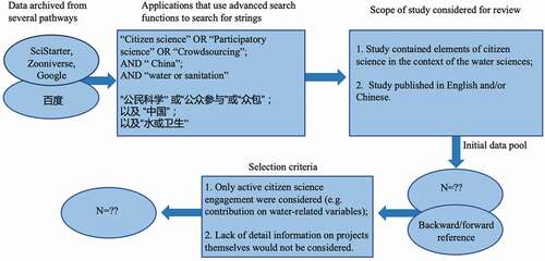
To identify as many CS projects as possible, particularly those projects from book chapters, programme websites, and technical reports, and described in Chinese language only at the present, here we utilised a semi-systematic review through searching directly not only on Google (the largest search engine in the world), but also on Baidu (the largest search engine in China). The geographical area we focused on here is ‘China’, under the scientific field ‘SDG 6’ (consisting of water and sanitation), searching for the keywords ‘citizen science’, along with its synonyms, including ‘participatory science’, ‘crowdsourcing’ in the English version via google and in the Chinese version (‘中国水或卫生相关的公民科学/公众参与/众包’) via Baidu. To eliminate irrelevant information as much as possible, both search engines were used with advanced search features.
To identify additional relevant projects, we also conducted a backward reference search, examining and reviewing papers cited in the literature selected. This was done as those materials could help expand our data pool once projects were identified with the scope of focusing on CS in a hydrological context and that actively engaged members of the public in the scientific research process. In this present work, the types of citizen involvement in which citizens contribute passively (e.g. participating in group discussions, completing questionnaires or local surveys) are beyond the CS boundary and were excluded. In total, 19 projects related to citizen science-based hydrological monitoring were identified ().
Figure 1. The flowchart of project review procedure.
2.3 Data analysis
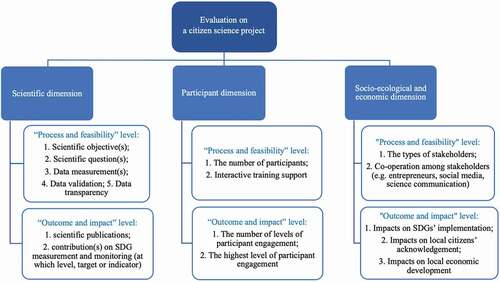
We used and adjusted an open evaluation framework to assess these citizen science (CS) projects as this can be applied to monitor progress during a project or when assessing impact at the end of a project (Kieslinger et al. Citation2018). Some of the projects we identified are still ongoing. Three core dimensions of evaluation emerged: (1) scientific dimension, (2) participant dimension and (3) socio-ecological and economic dimension. For each of these dimensions, evaluation indicators are proposed at the ‘process and feasibility’ level as well as at the ‘outcome and impact’ level.
2.3.1 Scientific dimension
In this dimension, a clearly defined research question is the scientific basis of all future activities. Therefore, indicators at the ‘process and feasibility’ level should help check the scientific grounding of CS projects, which are: scientific objective(s), scientific question(s), and data measurement(s). Since CS’s data is collected by non-experts, to keep data quality as good as data acquired from experts, two other indicators are also covered: data validation and data transparency. On the other hand, at the ‘outcome and impact’ level, projects should be evaluated based on traditional academic purposes, in which the most outstanding one is genuine scientific knowledge generation. Hence, indicators should focus on the types of output, that is, scientific publication(s), contribution(s) on SDG measurement and monitoring (at which level, target or indicator).
2.3.2 Participant dimension
Active engagement is the foundation of a project’s success. As such, in this dimension, at the process and feasibility level, engagement and communication strategies should be evaluated to see if participation and collaboration are facilitated, in which the indicators are the number of participants, and interactive training support. In terms of ‘outcomes and potential impact’ part, personal learning and gains are key, showing in the number of levels of participant engagement and the highest level of participant engagement.
2.3.3 Socio-ecological and economic dimension
Appropriate dissemination and outreach activities need to be considered at the ‘process and feasibility’ level to enhance the wider social, ecological and economic impacts of citizen science (CS) projects. Indicators are the types of stakeholders, and co-operation among stakeholders (e.g. entrepreneurs, social media, science communication). At the ‘outcome and impact’ level, the wider societal impacts usually show in the aspects of increasing civic resilience, social cohesion and innovation. Since this paper values CS projects’ influence on SDGs, three indicators are required, one is impacts on SDGs’ implementation, particularly on SDG 6, another is impacts on local citizens’ acknowledgement, the last one is impacts on local economic development ().
Figure 2. The adjusted citizen science (CS) project evaluation framework.
3 Results
3.1 Geography, chronology, and water science fields
The geographical scales of 19 citizen science (CS) projects identified in the semi-systematic review comprise four types: national (11), regional (3) and local (5). Although there are 11 projects aimed at conducting research at the national level, the data currently collected seems to come from specific areas. In China, four provinces/autonomous regions are the main active areas where more than one CS project has been conducted. In descending order of the number of water-related CS projects involved, these are Hong Kong, Beijing, Guangzhou and Shanghai. Water quality monitoring has become the most common type of CS project in China, covering a total of 11 projects. Furthermore, biodiversity-focused citizen science projects (including plant classification and bird monitoring) show direct contributions to water-related ecosystems in addition to indirectly contributing to water quality evaluation ().
Table 2. The basic information of each selected citizen science project
Aside from the Tsinghua Environment Monitoring Platform project, the remaining projects are ongoing and have been in progress for over 3 years. The earliest project (China Coastal Waterbird Census) started in 2005 and is an indirect-contribution project on water bodies. More than 150 volunteers have taken part in local bird watching surveys since its start. Two water quality monitoring projects began in 2006: the Finless Porpoise Survey in the Yangtze and the Blue Map App. The former is a five-year investigation along the river and Poyang and Dongting lakes, being undertaken by the Ministry of Agriculture. The second is an application developed by a non-profit organisation (Institute of Public and Environmental Affairs (IPE)) based in Beijing, to collect data about the quality of weather, air or water. It can be seen from that in the past 15 years, new CS projects have not appeared every year. And in the past two years (2019 and 2020), no new projects have been launched.
Figure 3. The emergence of new citizen science water-related projects (N = 19).
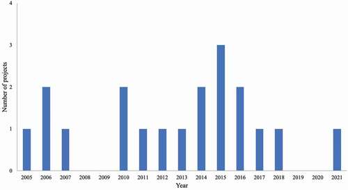
The largest number of CS projects was seen in 2015, comprising two water quality monitoring projects (MyH20 and Tsinghua Environment Monitoring Platform) and one water-related ecosystem monitoring project (Sanjiangyuan Ecosystem Monitoring). That was also the year when the UN SDGs were launched, including SDG 6 (water and sanitation). Although there is no direct evidence to show direct causality between the SDGs and the projects being launched, it could be one reason for the rise of CS in China. The years with the second largest number of CS projects were 2006, 2010 and 2016, in which two projects emerged per year. In 2006, two projects were the Finless porpoise survey in the Yangtze and the Blue Map App, which have been introduced above; In 2010, two projects were Computing for Clean Water (C4CW) and The Public Participation Network of the Environmental Impact Assessment (EIA). The former one is an international cooperation project between Tsinghua university and Cyberscience and the latter one is hosted by an NGO organisation, which is Chongqing Liangjiang Voluntary Service Center. And in 2016, one project was Black and Smelly Waters App, hosted by Chinese government agencies. The other project was Monitour, a platform to track the water contamination pollutant (E-waste) in Hong Kong. Wuhan Ecological Environment Public Welfare Observer became the newest CS project hosted by the local government after the outbreak of COVID-19 in China.
3.2 Scientific dimension evaluation
All the projects have at least one scientific objective, with two having more (MyH20 and the Finless Porpoise Survey in the Yangtze). MyH20, can be regarded as a combination type of water monitoring project being both a project and an organisation. The project aims to build the national water information network based on crowdsourcing and the participatory citizen science method. Four tasks have been carried out around water: water quality monitoring, local education, network community construction, and social practice (DIY services for college students around water). The programme undertaking the finless porpoise survey in the Yangtze comprises multiple tasks, counting the number of finless porpoises in addition to a water quality study exploring the reasons behind finless porpoises’ change in numbers. In water quality projects, most are conducted around investigating the basic parameters related to general water quality conditions through PackTest. Although two projects from Hong Kong are different, they share the same objective of monitoring a particular water-pollutant (e-waste) in Hong Kong. The biodiversity project here cannot directly use the data for one or more specific indicators of the surrounding water quality, the change of their distribution and number is able to reflect the bad or good conditions of the local water-related ecosystem, to some extent.
For scientific question(s), most CS projects at national or regional levels are trying to build an online platform to study the long-term water quality of biodiversity observation. A few local level projects focus only on the current status of a local community like the Inner Mongolia project (Solving Groundwater Contamination with Community Science), for which a local citizen scientist, Uchralt Otede, is responsible for testing the quality of water from a small well, because it was thought the well may have been polluted from nearby industrial wastewater. Reviewing the existing data distribution and targets from each selected project, western China has been paid more attention than other regions. The reasons behind this could be the unequal distribution of China’s water resources, with western China facing the most severe problems, including water shortages and water contamination.
In terms of data types, there are two main ones. Data from most of China’s CS water-quality projects are numerical values of indicators, while two App development projects (Black and Smelly Waters and The Blue Map) are different. Their data are collected as pictures, with the aim being to encourage users to report where they think water quality issues might exist, instead of testing water quality indicator data to prove which degree of quality of water bodies they are. Aside from local-level projects, the others are building data platforms to display what they have captured. Some have even built a global monitoring platform like Computing for Clean Water (C4CW), which is a scientific computation project launched by Chinese scientists in 2010, in collaboration with the Citizen Cyberscience Centre in Geneva. Another two projects are special as they focus on either public education (Chinese Water School) or awareness (China’s Water Safety Plan), rather than producing real-time testing water quality data. For those biodiversity observation projects, whether they are used for wildlife viewing or plant sampling, the instructions are very different, but they are usually recorded in the data inventory platform for long-term tracking.
In terms of data validation and transparency, the majority of projects, regardless of type, depend on repeated testing approaches to validate data. Computing for Clean Water (C4CW) has been the first project in China to achieve CS data validation through computing. Data transparency is relatively high for those projects carried out at the national/regional level with online platforms, where the data is easier for users to check because crowdsourcing is one of their most important methods for obtaining data. However, at local levels, especially those developed by local citizen scientists, it is difficult to access the data since they will not be published online unless direct contact is made with the project organisers. One project (China’s Water Safety Plan) uses social media ‘Weibo’ to monitor public data from various Chinese government departments, then reports the results online, which can be seen as a passive way for requiring data transparency.
In terms of data contribution to the SDGs, although the projects are contributing to SDG 6, only MyH20 is explicitly aware of the relevance, and has included the contents of SDG 6 (especially indicator 6.3) within its project’s principles. Two other projects (Sanjiangyuan Ecosystem Monitoring and China Water School) do have awareness of their contribution to sustainable development. The remaining projects only have stated awareness of water or biodiversity protection. Since the SDGs and the 2030 Agenda are the universal global framework for sustainable development, more efforts are needed here, to guide further monitoring work with clear goals and strategies. Without such monitoring and strategic work, the result might be double the effort for half the result such as undertaking repetitive tasks to enrich the data (required in SDG reporting). However, the fact is until now, there isn’t any evidence that the information was actually used in SDG reporting.
3.3 Participant dimension evaluation
In terms of participant training, a key finding is that only a few projects provide training materials to the public who are undertaking the checking (Freshwater Watch, China Nature Watch Biodiversity Information Platform (CNW programme), MyH20 and Wuhan Ecological Environment Public Welfare Observer); the other projects give little information in this aspect. For example, E-waste in Hong Kong and Sanjiangyuan eco-system monitoring, do not depend on participants simply uploading site photos to report, instead, they need participants to be able to use instruments to test indicators. It seems like that they rely on the people engaging already having relevant skills. Furthermore, ‘China’s Water Safety Plan’ aims to encourage citizens to report water issues to social media, in which participants do not need to have specific training. Additionally, the ‘Chinese Water School’ project focuses on water education, so courses may be regarded as training materials, not for individuals but more from the general scope.
In terms of participants’ scale, projects at national levels normally have over 100 participants joining, aside from ‘The Public Participation Network of the Environmental Impact Assessment (EIA)’ which lacks data in this aspect, so the accurate number of participants has not been obtained. At the regional level, the CNW programme has the largest number of participants, while for other projects, the number of participants is under 100. For Sanjiangyuan Eco-system Monitoring related participant number data could not be found from present materials but considering the project’s scale, it is expected to include around 50 participants. For projects at local levels, Xiangjiang Watcher has involved over 26,000 volunteers to participate in water quality monitoring and Monitour has shown that there are 200 trackers in its platform’s map. None of the remaining projects provide relevant information on participant numbers, and the relevant conveners needs to be contacted to obtain such details.
In most projects, according to the standard citizen science participation classification, participatory science becomes the highest level. MyH2O covers all levels of participant engagement (including crowdsourcing, distributed intelligence and participatory science), which could be a good model for other similar projects. Another project, China Water School, has potential to meet four levels of participant engagement, as it puts forward initiatives to educate students and carry out community activities throughout the Yangtze River basin, making them active participants in sustainable water management for further opportunities. For projects that need participants to report site geospatial or graphic information on water quality or biodiversity on water-related ecosystems, crowdsourcing is the most common type of participant engagement, as with Chinese Field Herbarium and Tsinghua’s experiment. However, with projects requiring real-time indicator data of water bodies, distributed intelligence is the most common form of participant engagement (e.g. Sanjiangyuan ecosystem monitoring).
3.4 Socio-ecological and economic dimension
Most of the projects have been launched by organisations including NGOs and academic institutions. The Chinese government is involved in a few projects: Sanjiangyuan Ecosystem Monitoring, Finless Porpoise Survey in the Yangtze, CNW programme, Black and Smelly Waters App, Wuhan Ecological Environment Public Welfare Observer and Xiangjiang Watcher. The first five projects are led by the government, but in the last the government only has a supporting role. Xiangjiang Watcher, launched by Green Hunan, aims to fill a critical gap in preserving the Xiang River through environmental education, advocacy, and an extensive riverkeeper network that monitors pollution levels. Multiple stakeholders join each project, which is very different from the ‘Solving Groundwater Contamination with Community Science’ project as the latter is a personally initiated project for which local people help by participating in a survey. Funding for these projects mainly comes from the sponsoring organisation itself or a foundation; a small amount comes from the government or enterprises. The Beijing local government and central government departments of environment/agriculture have become the major leaders in these projects. HSBC is the top company that supports the largest number of projects in the field of water science for citizens in China, covering the Finless Porpoise Survey in the Yangtze and Freshwater Watch. The latter has been launched by the EarthWatch Institute, which involves citizens in investigating the health of the world’s freshwater ecosystems.
The core impact of all the selected projects is to raise local people’s knowledge about water. However, projects differ in terms of their publicity because some have support from the government or institutions and can access official social media and new audiences, thereby making these projects more well-known and having a larger influence than projects hosted by local NGOs or NPOs. Thus, the most well-known projects are usually government-led ones, as mainstream official media will help in reporting and publicising. Furthermore, projects which require participants to contribute data through crowdsourcing can also increase awareness of the project while collecting data. The Black and Smelly Waters App is one such example, which was launched by China’s environment and housing ministries, reporting ‘black and smelly’ bodies of water and helping to bring awareness about overlooked sites of urban water pollution. Once water bodies are reported, government agencies will follow up on the issues within seven working days and users can track the progress of remediation efforts via the App.
Social platforms from other channels have also been used in different projects to increase awareness. Weibo and WeChat have become the most popular ones. For example, The Tsinghua Environment Monitoring Platform, developed a WeChat application named TEMP, enabling registered users to submit their descriptions and photos of rivers or lakes anonymously, or with their identity disclosed, with the automatically extracted GPS information of the sites from their mobile devices. Aside from those government-controlled projects, it is difficult for other projects to have a short-term impact from a policy perspective. However, one project, ‘China’s Water Safety Plan’ seems to have the potential to attract the attention of the relevant government agency quicker than others, as it uses Weibo for water issue reporting through publishing news using ‘@’ the corresponding government agency and waits for their response. The whole process is open and transparent, and anyone who uses Weibo can join the monitoring.
Similar results are seen in the impact of economic development, and all projects aim to carry out environmental governance. Projects are unlikely to bring direct economic benefits in the short term, aside from MyH2O, but measures have been taken to reduce the economic losses caused by water pollution. MyH2O, mainly focuses on drinking water and will help local communities to install water purifiers and build regular monitoring and maintenance systems. Clean drinking water may bring direct economic benefits, like increasing the income of the drinking fountain industry.
4 Discussion
A robust citizen science (CS) project must function well in at least two analysed dimensions simultaneously, as the results of this paper showed: scientific, participant, or socio-ecological and economic dimension. The major reason to mark this comment here is because for every CS monitoring research, the first principle is to be able to perform effectively for a long time. It is likely that the project will be interrupted due to manpower or other reasons (Robinson et al. Citation2018). The existence of CS in China is mainly dependent on non-governmental organisations and academic institutions. Only four projects were invested by national or local governments, most of which focused on biodiversity and supplemented by water quality surveys. Efforts to further apply CS, in a better way that fits with China’s political context, when seeking to address environmental data gaps, improve public awareness and even stimulate economic development will face three key questions, each corresponding to each dimension, as discussed in the following sections.
4.1 Scientific: acceptance of citizen science data
In the scientific dimension, data has been treated as a significant aspect to evaluate the output and impact of each citizen science (CS) project. Since the emergence of this field, the acceptance of citizen scientific data has been discussed at length. In China, according to the results in this paper, those projects’ data have not been reconciled and/or integrated into official data thoroughly. Instead, such data has normally been used as the data of NGOs that carry out public welfare investigation activities or the verification data of the scientific community. The role of CS used by the government is at its initial stage. The main function of such data used in the government supervision system, displayed via local government monitoring platforms, is to make them perceive that they may have a say in decision-making. However, the entire process from public reporting to government processing usually takes a substantial time. How CS data sources might be reconciled and/or integrated into real and in-time action faces two challenges: (1) government agencies with overlapping missions; (2) citizen science initiatives whose findings may challenge or diverge from official results.
4.2 Participant: expansion of citizen science projects
According to the project evaluation results on the participation dimension, except for the normal operation and steady growth of government-supported projects, the development speed of other projects is relatively slow. The two main reasons behind this are the lack of stable funds in addition to issues on management and resource integration among relevant organisations.
In respect of funding, many projects, especially those led by NGOs or non-profit (NPO) organisations, mostly rely on certain charitable foundations. However, foundations’ funds also depend on donations from various channels. In recent years, corporate social responsibility (CSR) has attracted the attention of the Chinese government and society, meaning obtaining funds from companies may be a promising option. Freshwater Watch and MyH2O provide good examples in terms of cooperation with companies. The former, for which the EarthWatch Institute is responsible, has been working with HSBC in water programmes for more than 5 years. As a local organisation in China, MyH2O cooperates to establish a sustainable water recycling plant for L’Oréal’s cosmetics production, thereby obtaining funds from L’Oréal. Generally, if citizen science organisations hope to obtain funding from companies, it is advantageous to understand their CSR and provide technical or strategic guidance to make them achievable.
For organisation management and resource integration, the ‘central-local divide’ between the Chinese central government and regional and provincial levels of government is one of the challenges facing environmental management and monitoring within the government. Although citizen science (CS) related organisations are registered and their data published at the national level, they and their data are monitored by local governments. As CS initiatives continue to grow, particularly for those projects set at national level aiming to build complete and comprehensive datasets, enabling local projects to tailor initiatives to their surroundings will be critical. Additionally, as the speed of economic and social development differs between places, local governments and related organisations have varying degrees of support and importance in this regard. For organisations that come from different regions but have the same purpose (e.g. water quality), when they collect data via citizen science, ensuring the same data quality and preventing the additional fragmentation of environmental monitoring also needs a solution, since real-time monitoring of data will have different standards depending on areas. Although groups from specific organizations shared some experiences, there is no conclusive evidence that they replicated CS activities in different locations. Given these, integrating existing organisational resources to form a robust science popularisation and management system may be able to solve the problem of rapid expansion of public participation in various projects.
Currently, in mainland China, there is no such system, no such leader association, but in Hong Kong, there is one, named CitizenScienceAsia. This is a new network, in the context of China, whereby people collect data to understand the environment, to collect evidence and protect rights, and for pure curiosity. However, considering the ‘one country, two systems’ policy system, the exchanges between mainland organizations and Hong Kong are not particularly frequent and close. In addition, the mainland adopts its own management method for NGOs, which will not be as open and free from government control as in Hong Kong, because in mainland China the number of civil organizations is strictly controlled. Therefore, starting from the Chinese mainland, the emergence of such a Chinese Citizen Science Alliance or management organization, preferably in the form of a university-led form, could make it easier to obtain support from the government and various industries to improve efficiency.
4.3 Socio-ecological and economic: establishment of citizen science credibility
The impact of citizen science may occur in policies, local communities, and economic development. Whether it can gain more recognition in a top-down policy system like China depends on the government. As a new data initiative and collection model, it requires a major change in China’s centralised authorization of ‘official’ data. For example, the ‘China Statistics Law’ stipulates that it is illegal for anyone to collect data except those who have been sanctioned by the government. Based on current observations on selected projects, half of these projects are contributed to by citizen scientists as crowdsourcing and/or distributed intelligence. The rest is contributed to by citizen scientists as participating sciences. Information and communication technology (ICT), as the main tool to empower citizens and enhance access to information, participation and empowerment, could reduce the accountability gap between government and citizens (Yakobi et al. Citation2020). Nevertheless, using such technology to collect relevant data in the name of the organisation without violating laws and regulations requires solutions.
The Black and Smelly Waters App is a fine example of ‘downwards accountability’ (Hsu et al. Citation2020). Citizens collectively hold service providers accountable using visible public concern or other communication tactics. Such ‘naming and shaming’ tactics raise the political cost of inaction, incentivizing managers to respond to avoid reputational costs. However, this is a government-controlled situation. For those projects hosted by NGOs, when generating and disseminating data, it remains to be seen whether the government will modify this regulation to decide to approve key citizen science(CS) programs, or choose a different response. From the perspective of CS, which work is most suitable to prompt the government to conduct further investigations or provide more data on environmental challenges, and which program(s) should be included in official channels requires consideration. Furthermore, how CS programs distinguish between real data gaps and political will not to monitor or share information is another issue to be further discussed and negotiated.
Conclusion
Within the framework of the UN sustainable development goals (SDGs), citizen science (CS), as an innovative field, is increasingly recognised by Western countries as a suitable approach to monitor the SDGs indicators. In this paper, we have shown that China, despite its different political system compared to those in the West, also has the potential of utilising CS within the context of the SDGs. Water resources have always played an important part in determining not only where people can live, but also their quality of life (Water Encyclopedia Citation2006). Five water-related aspects have now shown how CS could make contributions, in the terms of vegetation dynamics, precipitation, water flow, soil moisture and water quality. This study has examined 19 projects in China, 11 of which are about water quality, and the remainder could be seen to have indirect contributions to water science, albeit on water-related ecosystems.
The CS projects about water quality have various aims, including regular water quality monitoring, water pollution reporting, water education, and public supervision of government water treatment. Some projects, such as China’s water safety plan, are jointly initiated by media members, environmental protection, and legal circles. They operate as temporary, proof-of-concept projects aimed at sparking longer-term discussions around environmental data. Several projects focus primarily on establishing national databases, to improve water quality (Freshwater Watch, Black and Smelly Water App), or to inform biodiversity management and protection (Chinese Field Herbarium). Others, particularly the Xiangjiang Watcher, Sanjiangyuan Ecosystem Monitoring and China Nature Watch Biodiversity Information Platform are building frameworks for durable regional monitoring networks.
These phenomena and analysis results show that CS is suitable for use in China, especially when noticing that most of the current projects are well maintained. More importantly, the Chinese government has supported activities like Blue Map and allowed citizens to report water issues, in particular via online platforms. Nevertheless, the problem is that the understanding of the role of citizen science has not been fully developed in China. It is encouraging to see that academic institutions or universities have offered such courses/programs to systematically develop the capacity in this area. Present activities skip this step of generic education, instead tending to use the term citizen science without any explanation of its meaning, to encourage participant involvement. As a new discipline, CS has the potential application to promote SDGs in China, especially for Goal 6. Of all the projects examined, MyH2O may become a role model and a knowledge pioneer in the future as it operates quite well simultaneously among three dimensions. And the three most outstanding points from the MyH2O case are training materials (online workshop, local training), cooperation with multiple stakeholders (schools, companies and local communities) and explicit support for SDG 6.
The COVID-19 pandemic may inspire people to accelerate the implementation of green development models and SDGs in China. This can be seen in the commitment made by the Chinese government at the UN General Assembly in September 2020, that is, China will increase the speed of its nationally determined contributions, adopt stronger policies and measures, for peaking carbon dioxide emissions before 2030, and endeavouring by 2060, to achieve carbon neutrality. Therefore, how to use CS approaches to scientifically implement SDGs, especially when considering that private data collection is illegal without violating Chinese laws and regulations, and encourage more stakeholders, especially universities and enterprises to join, is worthy of attention and further discussion.
Acknowledgments
We thank the anonymous reviewers for helping improve the manuscript.
Disclosure statement
No potential conflict of interest was reported by the author(s).
References
- Bardaji R, Sanchez AM, Simon C, Wernand MR, Piera J. 2016. Estimating the under-water diffuse attenuation coefficient with a low-cost instrument: the KdUINO DIY Buoy. Sensors. 16(3):373. doi:https://doi.org/10.3390/s16030373.
- Bisung E, Elliott S, Abudho B, Karanja D, Schuster-Wallace C. 2015. Using photovoice as a community based participatory research tool for changing water, sanitation, and hygiene behaviours in Usoma, Kenya. Biomed Res Int. 2015:903025. doi:https://doi.org/10.1155/2015/903025.
- Briant Carant J. 2017. Unheard voices: a critical discourse analysis of the Millennium Development Goals’ evolution into the Sustainable Development Goals. Third World Q. 38(1):16–41.
- Buytaert W, Clark J. 2014. Citizen science in hydrology and water resources: opportunities for knowledge generation, ecosystem service management, and sustainable development. Front EarthSci. 2(26):1–21. doi:https://doi.org/10.3389/feart.2014.00026.
- China Water Risk. (2018). New ‘Water Ten Plan’ to Safeguard China’s Waters. CWR; [accessed 2021 Nov 23]. https://www.chinawaterrisk.org/notices/new-water-ten-plan-to-safeguard-chinas-waters/.
- Ci J. 2019. Democracy in China: the coming crisis. Cambridge (Massachusetts; London, England): Harvard University Press.
- De vos L, Leijnse H, Overeem A, Uijlenhoet R. 2017. The potential of urban rainfall monitoring with crowdsourced automatic weather stations in Amsterdam. Hydrol Earth Syst Sci. 21(2):765–777. doi:https://doi.org/10.5194/hess-21-765-2017.
- Desa UN. 2020. Recovering better: economic and social challenges and opportunities. New York: UN High-level Advisory Board.
- Dickinson JL, Zuckerberg B, Bonter DN. 2010. Citizen science as an ecological research tool: challenges and benefits. Annu Rev Ecol Evol Syst. 41(1):149–172. doi:https://doi.org/10.1146/annurev-ecolsys-102209-144636.
- Dobriyal P, Badola R, Tuboi C, Hussain S. 2016. A review of methods for monitoring streamflow for sustainable water resource management. Appl Water Sci. 7(6):2617–2628. doi:https://doi.org/10.1007/s13201-016-0488-y.
- Domingo-Marimon C, Masó J, Cristóbal J, Batalla M, Ninyerola M 2020. Remote sensing as a driving tool for Citizen Science phenology monitoring campaigns. Eighth International Conference on Remote Sensing and Geoinformation of the Environment (RSCy2020); March 16-18. Paphos, Cyprus; Wales: Proceedings of SPIE - The International Society for Optical Engineering. p.115241N–115241N-10.
- Fraisl D, Campbell J, See L, Wehn U, Wardlaw J, Gold M, Moorthy I, Arias R, Piera J, Oliver JL, et al. 2020. Mapping citizen science contributions to the UN sustainable development goals. Sustain Sci. 15(6):1735–1751. doi:https://doi.org/10.1007/s11625-020-00833-7
- Fritz S, See L, Carlson T, Haklay M, Oliver J, Fraisl D, Mondardini R, Brocklehurst M, Shanley LA, Schade S, et al. 2019. Citizen science and the United Nations Sustainable Development Goals. Nat Sustain. 2(10):922–930. doi:https://doi.org/10.1038/s41893-019-0390-3
- Gamon JA, Somers B, Malenovský Z, Middleton EM, Rascher U, Schaepman ME. 2019. Assessing vegetation function with imaging spectroscopy. Surv Geophys. 40(3):489–513. doi:https://doi.org/10.1007/s10712-019-09511-5.
- Global Citizen Science Partnership (GCSP). 2017. Citizen science for the SDGs; [accessed 2021 Nov 22]. http://citizenscienceglobal.org/projects.html.
- Gruber A, De Lannoy G, Albergel C, Al-Yaari A, Brocca L, Calvet J-C, Colliander A, Cosh M, Crow W, Dorigo W, et al. 2020. Validation practices for satellite soil moisture retrievals: what are (the) errors? Remote Sens Environ. 244:111806.
- Haklay M 2015. Citizen Science and Policy: a European Perspective. Wilson Center; accessed 2019 Aug 26]. https://www.wilsoncenter.org/publication/citizen-science-and-policy-european-perspective.
- Howes M, Wortley L, Potts R, Dedekorkut-Howes A, Serrao-Neumann S, Davidson J, Smith T, Nunn P . 2017. Environmental sustainability: a case of policy implementation failure? Sustainability (Basel, Switzerland). 9(2):165.
- Hsu A, Weinfurter A, Tong J, Xie Y. 2020. Black and Smelly Waters: how citizen-generated transparency is addressing gaps in China’s environmental management. J Environ Policy Plan. 22(1):138–153. doi:https://doi.org/10.1080/1523908X.2019.1654365.
- IAEG-SDGs. 2020. Tier Classification for Global SDG Indicators. New York: UN Statistical Commission.
- Kampf S, Strobl B, Hammond J, Anenberg A, Etter S, Martin C, Puntenney-Desmond K, Seibert J, Puntenney-Desmond K, Seibert J, et al. 2018. Testing the waters: mobile apps for crowdsourced streamflow data. Washington (D.C.): Eos; p. 99.
- Khan MI, Chang Y-C. 2018. Environmental challenges and current practices in China-A thorough analysis. Sustainability (Basel, Switzerland). 10(7):2547.
- Kieslinger B, Schäfer T, Heigl F, Dörler D, Richter A, Bonn A. 2018. Evaluating citizen science - Towards an open framework. In: Hecker S, Haklay M, Bowser A, Makuch Z, Vogel J, Bonn A, editors. Citizen Science: innovation in Open Science, Society and Policy. London: UCL Press; p. 81–95.
- Kovács K, Hemment D, Woods M, Van der Velden N, Xaver A, Gi Esen RH, Burton VJ, Garrett NL, Zappa L, Long D, et al. 2019. Citizen observatory based soil moisture monitoring – the GROW example. Hung Geogr Bull. 68(2):119–139. doi:https://doi.org/10.15201/hungeobull.68.2.2
- Li C, Wei D, Vause J, Liu J. 2013. Towards a societal scale environmental sensing network with public participation. Int J Sustain Dev World Ecol. 20(3):261–266. doi:https://doi.org/10.1080/13504509.2013.779326.
- Liski AH, Koetse MJ, Metzger MJ. 2019. Addressing awareness gaps in environmental valuation: choice experiments with citizens in the Inner Forth, Scotland. Reg Environ Change. 19(8):2217–2229. doi:https://doi.org/10.1007/s10113-018-01458-4.
- Lowry CS, Fienen MN. 2013. CrowdHydrology: crowdsourcing hydrologic data and engaging citizen scientists. Ground Water. 51(1):151–156. doi:https://doi.org/10.1111/j.1745-6584.2012.00956.x.
- Lu Y, Zhang Y, Cao X, Wang C, Wang Y, Zhang M, Ferrier RC, Jenkins A, Yuan J, Bailey MJ, et al. 2019. Forty years of reform and opening up: China’s progress toward a sustainable path. Sci Adv. 5(8):Eaau9413. doi:https://doi.org/10.1126/sciadv.aau9413
- Marco B. 2011. Measuring soil water content: a review. HortTechnology (Alexandria, Va). 21(3):293–300.
- Maser C. 2015. Oceans in Crisis—Human Garbage. JAMB. 2(3):3. doi:https://doi.org/10.15406/jamb.2015.02.00030.
- Muste M, Lee K. 2013. Quantification of hysteretic behavior in streamflow rating curves. In: Wang ZY, Lee JHW, Gao JZ, and Cao SY, editors. Proceedings of the 35th IAHR World Congress, September 8-13. Chengdu China, Beijing: Tsinghua University Press.
- NGS. 2019. Surface water; [accessed 2021 Nov 22]. https://www.nationalgeographic.org/encyclopedia/surface-water/.
- Quinlivan L, Chapman DV, Sullivan T. 2020. Applying citizen science to monitor for the Sustainable Development Goal Indicator 6.3.2: a review. Environ Monit Assess. 192(4):218. doi:https://doi.org/10.1007/s10661-020-8193-6.
- Robinson L, Cawthray JL, West SE, Bonn A, Ansine J. 2018. 10 principles of citizen science. In: Hecker S, Haklay M, Bowser A, Makuch Z, Vogel J, and Bonn A, editors. Citizen science: innovation in open science, society and policy. London: UCL Press; p. 27-40.
- Rotman D, Preece J, Hammock J, Procita K, Hansen D, Parr C, Lewis D, Jacobs D 2012. Dynamic changes in motivation in collaborative citizen-science projects. CSCW '12: Proceedings of the ACM 2012 conference on computer supported cooperative work, February 11-15. Seattle, New York: ACM; p. 217–226.
- Rufino MC, Weeser B, Stenfert Kroese J, Njue N, Gräf J, Jacobs S, Kemboi Z, Ran AM, Cerutti PO, Martius C, et al. 2018. Citizen scientists monitor water quantity and quality in Kenya. Center for International Forestry Research (CIFOR). 230.
- Sachs J, Schmidt-Traub G, Kroll C, Lafortune G, Fuller G, Woelm F 2020. The sustainable development goals and COVID-19. Sustainable Development Report 2020. Cambridge: Cambridge University Press.
- Schepaschenko D, See L, Lesiv M, Bastin J, Mollicone D, Tsendbazar N, Bastin L, McCallum I, Laso B, Juan C, et al. 2019. Recent advances in forest observation with visual interpretation of very high-resolution imagery. Surv Geophys. 40(4):839–862. doi:https://doi.org/10.1007/s10712-019-09533-z
- Schlesinger W, Jasechko S. 2014. Transpiration in the global water cycle. Agric For Meteorol. 189-190:115–117. doi:https://doi.org/10.1016/j.agrformet.2014.01.011.
- Stevens M, Vitos M, Lewis J, Haklay M 2013. Participatory monitoring of poaching in the Congo basin.
- Strobl B, Etter S, Van Meerveld I, Seibert J. 2019. The CrowdWater game: a playful way to improve the accuracy of crowdsourced water level class data. PloS One. 14(9):e0222579. doi:https://doi.org/10.1371/journal.pone.0222579.
- Tone S. 2018 Jul 21. Why ‘Citizen Science’ Faces an Uphill Climb in China. Sixth Tone. accessed 2021 Nov 23]; https://www.sixthtone.com/news/1002655/why-citizen-science-faces-an-uphill-climb-in-china.
- UNEP. 2019. Global environment outlook – GEO-6: healthy. Cambridge: Cambridge University Press.
- UNSD. 2015. The millennium development goals report. New York: UN Publication.
- UNSD. 2020. Home - E-Handbook on SDG Indicators - UN Statistics Wiki; [accessed 2021 Nov 22]. https://unstats.un.org/wiki/display/SDGeHandbook/Home.
- USGS. 2019a. How much water is there on earth?; [accessed 2021 Nov 22]. https://www.usgs.gov/special-topic/water-science-school/science/how-much-water-there-earth?qt-science_center_objects=0#qt-science_center_objects.
- USGS. 2019b. Where is earth’s water?; [accessed 2021 Nov 23]. https://www.usgs.gov/special-topic/water-science-school/science/where-earths-water?qt-science_center_objects=0#qt-science_center_objects.
- Wang X, Zhang Y. 2019. The rise of participatory governance in China: empirical models, theoretical framework, and institutional analysis. Legal Scholarship Repository. 13(1):24–71. Pennsylvania: University of Pennsylvania Carey Law School.
- Water Encyclopedia. 2006. Uses of water; [accessed 2021 Nov 23]. http://www.waterencyclopedia.com/Tw-Z/Uses-of-Water.html.
- Weng X, Dong Z, Wu Q, Qinv Y. 2015. China’s path to a green economy: decoding China’s green economy concepts and policies. London: IIED Country Report, IIED.
- Yakobi K, Scholtz B, Vom Berg B. 2020. A conceptual model of the challenges of social media big data for citizen e-participation: a systematic review. In: Hattingh, M, Matthee, M, Smuts, H, Pappas, I, Dwivedi, Y.K, and Mäntymäki, M Responsible design, implementation and use of information and communication technology, Lecture notes in Computer Science. Cham: Springer International Publishing; p. 247–259.
- Yang A, Zhang H, Stewart R, Nguyen K. 2018. Enhancing residential water end use pattern recognition accuracy using self-organizing maps and K-means clustering techniques: autoflow v3.1. Water. 10(9):1221. doi:https://doi.org/10.3390/w10091221.
- Zhang G, Luo S, Jing Z, Wei S, Ma Y. 2020. Evaluation and forewarning management of regional resources and environment carrying capacity: a case study of hefei city, Anhui province, China. Sustainability (Basel, Switzerland). 12(4):1637.