
 ?Mathematical formulae have been encoded as MathML and are displayed in this HTML version using MathJax in order to improve their display. Uncheck the box to turn MathJax off. This feature requires Javascript. Click on a formula to zoom.
ABSTRACT
Ecological protection and restoration helps reverse the ecological degradation caused by climate change and human activities. Accurately identifying the priority areas for ecological protection and restoration is key to achieving effective differentiated ecosystem management. Taking the Miyun Reservoir Basin as a case study, this study evaluated the spatial patterns of ecosystem service importance, ecosystem stability, and ecosystem quality degradation. Then, this study identified priority areas for ecological protection and restoration and proposed differentiated ecosystem management strategies for different restoration units. The results showed that: (1) the proportions of important and extremely important areas for water conservation, soil conservation, carbon sequestration, and biodiversity conservation increased by 7.55%, 2.51%, 19.54%, and 16.78%, respectively, from 2000–2015, but there were obvious spatial differences among different ecosystem services; (2) the proportion of areas with low ecosystem stability reached 9.06% in 2015, and these sites were concentrated in the northwester and eastern mountainous areas; (3) this study further identified priority areas of 1961.51 km2 for ecological conservation, and these areas was mainly concentrated in the western mountainous areas and the Miyun Reservoir and its periphery. Additionally, the identified key ecological restoration areas covered an area of 1138.27 km2. These regions were mainly concentrated in the northeastern mountains and southwestern plain of the study area. This study provides a new perspective for the systematic identification of the priority areas for ecological protection and restoration, and also offer important guidance for implementing differentiated ecosystem management strategies and effectively protecting water resources.
1. Introduction
Ecological issues have always been an important problem for human societies. With rapid socioeconomic development and continuous population growth, the pressure created by high-intensity human activities on the ecological environment has been increasing (Bonheur and Lane Citation2002; Haddad et al. Citation2015). Global ecological problems such as global warming, sea level rise, deterioration of the ozone layer, biological invasions and biodiversity decline are becoming increasingly prominent. In addition, rapid urbanization has resulted in an increase in artificial surface and a loss of natural habitat and has further led to the degradation of various ecosystem services (Chen et al. Citation2016, Citation2022; Dong et al. Citation2020; Ouyang et al. Citation2021). Therefore, it is necessary to implement ecological protection and restoration.
Ecological protection and restoration is the process of restoring or generally restoring the original structure and function of degraded, damaged or destroyed ecosystems (Jørgensen Citation2013; Fang et al. Citation2020). In the face of complex and high-intensity ecological environmental problems and threats to human existence, theories and technologies related to ecological protection and restoration have become the focus of research in related disciplines (Fu et al. Citation2019). Earlier related studies were based on qualitative spatial planning (MacMillan et al. Citation2007) and quantitative pattern analysis (Huck et al. Citation2011). However, these earlier ecological protection and restoration studies focused more on single factors and small-scale levels, such as polluted sites, rivers, wetlands and mines, and failed to reflect the systematization and integrity of mountains, water, forests, farmland, lakes, grasslands and sand (Yi et al. Citation2020; Wang et al. Citation2022). Therefore, in view of the transformation of ecological protection and restoration in the new era from autonomous regional governance to whole-domain spatial design, there is an urgent need to systematically understand the necessity of ecological protection and restoration of different spatial units and the feasibility of goals to realize the overall protection, systematic restoration and comprehensive management of mountain, water, forest, farmland, lake, grassland and sand landscapes (Fu et al. Citation2019; Wang et al. Citation2021).
In China, ecological protection and restoration has become a national strategic project, and vigorous implementation of major projects to protect and restore important ecosystems has become an important goal to achieve sustainable development (Guan et al. Citation2021). In recent years, the Chinese government has launched a series of pilot projects to protect and restore the ecology of mountains, rivers, forests, lakes, lakes and grasses, and scholars have extensively explored the theory and technology of ecological conservation and restoration as well as regional practices. For example, ecological protection and restoration zoning identification is usually considered in terms of habitat quality (Li et al. Citation2021; Rao et al. Citation2021), and morphological spatial pattern analysis (Chen et al. Citation2021), state trend analysis (Kang et al. Citation2021), and ecosystem service value assessment (Wang et al. Citation2022; Wu and Meng Citation2022; Zhang et al. Citation2022). However, how to accurately identify the key areas for regional ecological conservation and restoration and how to coordinate the systematic management of mountains, rivers, forests, fields, lakes and grasslands are still challenges for the restoration of territorial and spatial ecology.
As an important surface drinking water source and an important ecological functional area in Beijing, Miyun District occupies a very important ecological and strategic position. However, high-intensity human disturbance and climate change have induced multiple ecological problems, such as ecological function degradation, agricultural nonpoint source pollution, mine geological disasters and water environmental quality degradation, which threaten regional ecological security and sustainable development. Therefore, taking Miyun District as a study area, this study evaluated the spatial patterns of ecosystem service importance, ecosystem stability, and ecosystem quality degradation. Then, this study identified priority areas for ecological conservation and restoration and proposed differentiated ecosystem management strategies for different restoration units. Our study aimed to provide an important decision-making reference for sustainable and safe water resource utilization and effective ecological conservation and restoration in Miyun District and Northeast Beijing.
2. Materials and methods
2.1. Study area
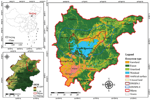
Miyun District is in northeastern Beijing, China, with longitudes of 116°39′33“~117°30′25‘E and latitudes of 40°13′7’~40°47′57“N (). It is the largest district among the 16 districts in Beijing and has a land area of 2,229.45 km2, which accounts for 13.26% of the total area of Beijing. Miyun District is surrounded by mountains to the east, north and west, and the Miyun Reservoir, as an important source of potable water and a strategic reserve of water resources in Beijing, lies in the middle of the study area. The Miyun Reservoir is also a key node of the Chaobai River Basin system and plays an important and central role in regulating the water resources of the whole area. It has four major functions: flood prevention and mitigation, provision of urban water supply, ecological conservation, and south-to-north water transfer and storage. The maximum water surface area of the Miyun Reservoir is 188 km2, and the maximum reservoir capacity is 43.75 × 10⁸ m3. Miyun District belongs to the temperate subhumid continental monsoon climate. There are many rivers in Miyun District, and the total length of rivers is 841.7 km.
Figure 1. The location of study area.
2.2. Data sources
There were four types of data sources in this study. The administrative boundary and digital elevation model (DEM) (30 m × 30 m) were downloaded from the Aerospace Information Research Institute, Chinese Academy of Sciences (http://www.aircas.cas.cn). The land use and land cover (LULC) (30 m × 30 m), normalized difference vegetation index (NDVI), net primary productivity (NPP), GDP, and nature reserve data were downloaded from the Resource and Environment Science and Data Centre (http://www.resdc.cn). Meteorological data were downloaded from the China Meteorological Data Service Centre (http://data.cma.cn). The raster data had a unified spatial resolution of 30 × 30 m. Our main research data covered two different periods, 2000 and 2015.
2.3. Methods
2.3.1. Assessment of ecosystem service importance
Ecosystem services refer to the environmental conditions and benefits offered by ecosystems that sustain and encourage the survival of humans and other species, including provisioning services, regulating services, supporting services, and cultural services (Zhao et al. Citation2020; Fan et al. Citation2022). The assessment of ecosystem services can identify areas with important ecological functions and provide a scientific and effective basis for ecosystem restoration and the zonation of ecological functions. In this study, five categories of ecosystem services, including water conservation, soil conservation, carbon fixation, biodiversity conservation, and windbreak and sand fixation, were selected for assessing ecological conservation importance. Referring to the relevant literature (Jin et al. Citation2021), this study first assessed different ecosystem services and then classified the study area into four classes based on rated importance: extremely important (0–50%), highly important (50–75%), moderately important (75–90%), and generally important (90–100%). Considering the irreplaceability of different ecosystem service functions, the comprehensive ecosystem service importance in Miyun District was assessed by assuming the maximum values of different ecosystem services. The equations for calculating different ecosystem services are shown below.
2.3.1.1. Water conservation
Water conservation refers to an ecosystem interacting with water through its unique structure to intercept, permeate and accumulate precipitation and realize the regulation of water flow and water circulation through evaporation. Water conservation can be calculated as follows (Gong et al. Citation2017):
where WC represents water conservation (m3); Pi represents precipitation (mm); ETi is evapotranspiration (mm); Rfi is rainstorm runoff (mm); Ai represents area of the ith ecosystem (m2); and j represents the total number of ecosystem types in the study area.
2.3.1.2. Soil conservation
Soil conservation occurs that ecosystem (such as forests, grasslands, etc.) intercept or reduce water-driven soil erosion through their structures and processes. Soil conservation can be calculated as follows (Pan et al. Citation2020):
where SC represents the soil conservation (t·hm−2·a−1); SEp is the potential soil erosion (t· hm−2·a−1); SEa is the actual soil erosion (t·hm−2·a−1); R is the rainfall erosion force factor (MJ·mm·hm−2·h−1·a−1); K is the soil erodibility factor (t·hm2·h·hm−2·MJ−1·mm−1); LS is the topography factor; C is the vegetation cover factor; and P is the soil conservation measure factor.
2.3.1.3. Carbon fixation
Carbon fixation refers that plants in the ecosystem convert atmospheric carbon dioxide into carbohydrates through photosynthesis, which are then fixed in the plant body or soil in the form of organic carbon. Carbon fixation can be expressed as follows (Chang et al. Citation2021):
where CS is the carbon sequestration (g·C·m−2·a−1); B is the ecosystem biomass (g·C·m−2·a−1); and C is the conversion coefficient. The conversion coefficients of forest, scrub and grassland are 0.5, 0.5 and 0.45, respectively.
2.3.1.4. Biodiversity conservation
Biodiversity refers to the ecosystem, genetic diversity and species diversity of all organisms on Earth and the genes and habitats in which they live, and it can be expressed as follows (Xu et al. Citation2017):
where C denotes the total cost of the conservation system; B denotes the boundary correction of the conservation system; S denotes the compensation value for not meeting the conservation target; and CostThershold(t) is the compensation value for exceeding the cost threshold. The conservation targets in this study were set at 50%, 20% and 10% of the total area of the respective habitats of the I, II and III protected species.
2.3.1.5. Windbreak and sand fixation
Windbreak and sand fixation refer that ecosystem (such as forests, grasslands, etc.) intercepts or reduces wind-driven soil erosion through their structures and processes. And is closely related to factors such as precipitation, wind speed, soil physical and chemical properties, and vegetation cover. Windbreak and sand fixation can be expressed as follows (Kong et al. Citation2019):
where G is the unit area of windbreak and sand fixation (kg∙m−2); SLQ is the potential soil erosion (kg∙m−2); SL is the actual soil erosion under vegetation cover (kg∙m−2); Qmax is the maximum wind operation (kg∙m−1); Qmax-Q is the potential wind operation (kg∙m−1); S is the critical plot length (m); SQ is the potential critical plot length (m); Z is the maximum downwind wind erosion in m; Z is the maximum downwind wind erosion distance (m); WF is the climatic factor (kg∙m−1); K’ is the soil crust factor (dimensionless); EF is the soil erodibility factor (dimensionless); SCF is the surface roughness factor (dimensionless); and C is the vegetation factor (dimensionless).
2.3.1.6. Integrated ecosystem services importance
where ESI is the ecosystem service importance, and Si represents the importance of different ecosystem services.
2.3.2. Ecosystem stability assessment
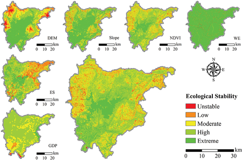
This study selected five factors, including elevation, slope, human activities (GDP per capita), water erosion intensity, NDVI and ecosystem services, to assess ecosystem stability in Miyun District. The different indicators were normalized and overlaid with equal weights. Ecosystem stability was divided into five levels based on the natural breakpoint method: very stable, highly stable, moderately stable, low stability and unstable. Ecosystem stability can be expressed as follows:
where ES denotes the ecosystem stability; Mi denotes the ith ecosystem stability evaluation factor; and n denotes the number of ecosystem stability evaluation factors.
2.3.3. Ecological protection and restoration area identification method
The ecological protection and restoration space contains two central considerations. One pertains to protecting key areas for the country to address food security, ecological safety, biodiversity, and climate change. The other pertains to restoring areas that are currently highly vulnerable and sensitive to declining ecological space and quality. Therefore, this study was conducted to create an integrated, comprehensive and systematic spatial identification index system for ecological protection and restoration (). Ecologically important areas were identified for ecological protection by accounting for several key factors, such as drinking water source protection zones, ecological red lines, nature reserves, permanent basic agricultural land, and the importance of ecosystem service functions. Several key factors, such as ecosystem stability, ecologically damaged spaces, and changes in ecological quality (vegetation index, net primary productivity, and ecosystem services), were considered to identify key areas for ecological restoration ():
Figure 2. Ecological protection and restoration area identification method (WSP-Water Source Protection Zone; RED-Ecological Red Line; NR-Nature Reserves; PDF-Permanent Basic Farmland; WC-Water Conservation; SC-Soil Conservation; CF-Carbon Fixation; BC-Biodiversity Conservation; WS-Windbreak and Sand Fixation; ESI-Ecological Service Importance; EPA-Ecological Protection Area; ES-Ecosystem Stability; EDS-Ecologically Damaged Space; EQD-Ecological Quality degradation; ERA-Ecological Restoration Area; EPRA-Ecological Protection and Restoration Area.).
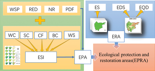
Table 1. Spatial identification index system for ecological protection and restoration.
where is the ecological protection area,
is the drinking water source protection zone,
is the ecological protection red line value,
is the nature reserve,
is the permanent basic farmland, and
is the extremely important area of ecosystem service function.
where is the ecological restoration area,
is the area with very low ecosystem stability,
is the ecologically damaged space, and
is the area with reduced ecological quality.
3. Results
3.1. Spatial pattern of ecosystem service importance
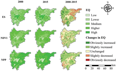
The distribution pattern of different ecosystem services in Miyun District had obvious spatial and temporal differences (). The extremely important areas for water conservation were concentrated mainly in Miyun Reservoir and the surrounding areas. The extremely important areas for soil conservation and carbon fixation were concentrated mainly in the north-western and eastern mountainous areas. The extremely important areas for biodiversity conservation and windbreak and sand fixation were concentrated mainly in the southern plains and the northern low mountainous hilly areas. According to the statistical results (), the percentages of areas above the important level of water conservation, soil conservation, carbon fixation, biodiversity conservation, and integrated ecosystem services in Miyun District in 2015 were 40.68%, 22.94%, 42.77%, 51.28%, and 51.39%, respectively, with increases of 7.55%, 2.51%, 19.54%, 16.78%, and 6.51% compared with 2000. The importance of ecosystem services showed a significant increasing trend.
Figure 3. Spatial and temporal variation in the importance of ecosystem services in Miyun District (WC- Water Conservation; SC- Soil Conservation; CF- Carbon Fixation; BC-Biodiversity conversation; WS-Windbreak and Sand Fixation; ES- Ecosystem Services. The same below.).
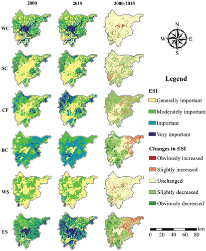
Table 2. Percentage of area of importance of different classes of ecosystem services in 2000–2015 (Unit: %).
As shown in , water conservation and windbreak and sand fixation did not change significantly from 2000 to 2015, and only 5.79% and 9.28% of the area showed an increasing trend (), respectively, and these areas were mainly localized in the southwestern plains. The soil conservation slightly decreased, remained unchanged, or slightly increased in 7.06%, 56.94%, and 35.99% of areas, respectively. The areas with decreases were mainly concentrated in the southern plains, and the areas with increases were mainly distributed in the southeast. Carbon fixation increased slightly, accounting for 57.71%, mainly in the north-western and eastern mountains, while the areas where carbon fixation decreased were mainly distributed in the north-eastern low mountains, accounting for 3.29%. The areas where biodiversity conservation obviously decreased, slightly decreased, remained unchanged, slightly increased, or obviously increased accounted for 3.14%, 15.95%, 30.96%, 39.63%, and 10.32%, respectively. The areas with increases were mainly distributed in the north-western mountains and south-eastern plains, and the areas with decreases were mainly concentrated in the north-eastern mountains. There was clear spatial heterogeneity among the evolutionary characteristics of the different ecosystem services.
Table 3. Percentage of area changed by different classes of ecosystem services, 2000–2015 (Unit: %).
3.2. Spatial pattern of ecosystem stability
The northwest and northeast of the study area had high elevations and large slopes, and the valley rivers were densely distributed (). The areas southwest and northeast of the Miyun Reservoir had intense human activities, low vegetation cover, and relatively low ecosystem services, which had obvious regional differences in their impacts on ecosystem stability. The results showed that the proportions of unstable, low stability, moderately stable, highly stable and very stable areas of the ecosystem in Miyun District accounted for 1.20%, 7.86%, 21.61%, 47.57% and 16.23%, respectively. The highly stable and very stable areas were mainly located around the Miyun Reservoir and in the southwestern plains. These areas with unstable or low ecosystem stability were concentrated in the north-western and eastern mountains, and the ecosystem stability along the banks of river systems was also relatively low.
Figure 4. Spatial distribution of ecological stability in Miyun District.
3.3. Spatial pattern of ecosystem quality degradation
As shown in , the areas with degraded ecosystem services in Miyun District from 2000 to 2015 were concentrated mainly in the north-eastern mountains and low hill areas, accounting for 21.64% of the total area, and the areas with obviously degraded and slightly degraded ecosystem services accounted for 2.53% and 19.11%, respectively. The areas with a high NDVI were mainly concentrated in the north-western and eastern mountains. The area with degraded NDVI accounted for 8.86%, the spatial distribution was relatively dispersed, and areas with obviously degraded and slightly degraded NDVI accounted for 0.30% and 8.56%, respectively. The areas with high NPP values were mainly concentrated in the eastern mountains and the southwestern plains. The areas with degraded NPP were concentrated in the southwestern plains, accounting for 6.90% of the total area, and the areas with obviously degraded and slightly degraded NPP accounted for 0.50% and 6.40%, respectively.
Figure 5. System quality degradation evaluation in Miyun District.
3.4. Identification of priority areas for ecological protection and restoration
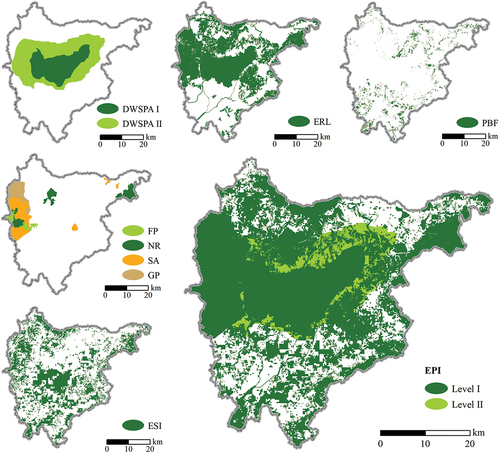
As shown in , the areas of Miyun Reservoir drinking water source Level I and II protected areas were 281.22 km2 and 494.41 km2, respectively, accounting for 12.61% and 22.18% of the total area. The area of the ecological red line was 1106.77 km2, accounting for 49.64%, and was mainly concentrated in the north-western and eastern mountains and the Miyun Reservoir. Nature reserves covered 321.27 km2 and accounted for 14.41% of the total area, mainly concentrated in Yunmeng Mountain, Wuling Mountain, and Yunfeng Mountain. Permanent basic farmland covered 112.15 km2 and accounted for 5.03% of the total area, mainly distributed in the southern plains and the low hilly areas north of the Miyun Reservoir. The extremely important areas of ecosystem services covered 832.56 km2 and accounted for 37.34%, and they were mainly in the north-western and south-eastern mountains and the Miyun Reservoir and surrounding areas. In total, the important ecological protection areas encompassed 1641.72 km2 and accounted for 73.64% of the total area.
Figure 6. Identification of important ecological protection areas in Miyun District (DWSPA- Drinking Water Source Protection Area; ERL-Ecological Red Line; PBF-Permanent Basic Farmland; FP-Forest Park; NR-Nature Reserve; SA-Scenic Area; GP-Geological Park; ESI-Ecosystem Service Importance).
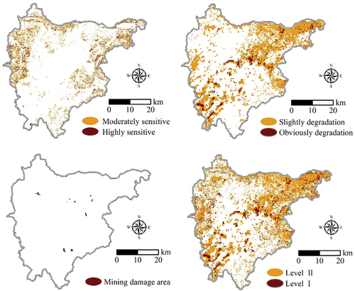
In this study, these areas with unstable or low ecosystem stability were selected as moderately and highly sensitive areas, respectively. As shown in , the ecologically sensitive areas were concentrated mainly in the steep slopes of the western and eastern mountains as well as in areas with low vegetation cover, covering 201.99 km2 and accounting for 9.06% of the total area. The moderately sensitive and highly sensitive areas accounted for 7.86% and 1.20%, respectively. The results of the ecosystem quality assessment showed that the areas of ecological degradation in Miyun District covered 827.91 km2 and accounted for 37.22% of the total area, and the areas with obvious and slight ecological degradation accounted for 3.03% and 34.19%, respectively, which were mainly concentrated in the north-eastern mountains and southwestern plains. Five mining areas were selected as the main ecological damage areas, and they covered 5.25 km2 and accounted for 0.24% of the regional area. The results of the spatial overlay showed that key ecological restoration areas covered 1138.27 km2 and accounted for 51.06% of the total area, which were mainly concentrated in the northeast and southwest of the study area.
Figure 7. Identification of key areas for ecological restoration in Miyun District.
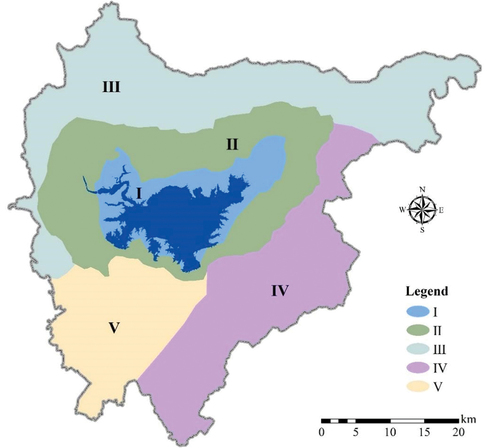
Based on the above research results, this study identified and determined six major ecological protection and restoration areas: (1) the drinking water source protection area of Miyun Reservoir; (2) the northeast hilly area of Miyun Reservoir; (3) the north-western mountains key protection area; (4) the north-eastern mountains key protection area; (5) the eastern mountains protection and restoration areas; and (6) the southwestern plains critical restoration area (). Then, we further divided the research area into five ecological protection and restoration units to better realize the zoning and precise implementation of ecological protection and restoration policies (). The ecological protection and restoration units included (I) the core area of strategic water source protection; (II) the comprehensive improvement area of the small watershed around the reservoir; (III) the northern forest-nurturing and ecological security barrier belt; (IV) the eastern soil and water conservation and ecological collaboration management area; and (V) the southern farmland quality improvement and village environmental management area. The five different ecological protection and restoration units accounted for 12.61%, 22.18%, 29.02%, 21.91%, and 14.28% of the total area, respectively.
Figure 8. Key areas of ecological protection and restoration in Miyun District.
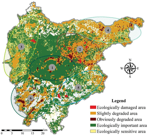
Figure 9. Ecological Protection and Restoration Unit in Miyun District ((I) the core area of strategic water source protection; (II) the comprehensive improvement area of the small watershed around the reservoir; (III) the northern forest-nurturing and ecological security barrier belt; (IV) the eastern soil and water conservation and ecological collaboration management area; and (V) the southern farmland quality improvement and village environmental management area.).
4. Discussion
4.1. Spatial identification method for landscape ecological protection and restoration in Miyun District
This study identified key areas for ecological protection and restoration by comprehensively considering several key factors, such as protected zones around drinking water sources, ecological red lines, nature reserves, permanent basic agricultural land, ecosystem service importance, ecological sensitivity, ecologically damaged spaces, and changes in ecological quality. Compared with previous studies (Wang et al. Citation2021; Wu and Meng Citation2022) that considered only ecosystem service importance or relied on other ecological evaluation methods, our study index system was more comprehensive. Our methods considered factors such as the stability index evaluation of the ecosystem and permanent basic farmland, while the evaluation results can also clarify the mechanisms needed for ecological protection and restoration, whether due to the importance of ecosystem services, basic farmland protection or ecosystem stability. The results will effectively correct the direction of ecological protection and restoration strategies utilized for current spatial planning at the regional scale. This includes optimal assessment of the three priorities of production, agriculture and ecology. Additionally, this work can provide effective support for future spatial optimization and improve ecological agriculture and industrial development.
This study integrates the theories of landscape ecology, ecosystem ecology and sustainable development to link ecological conservation and restoration practices with theories of ecosystem quality, ecosystem stability and ecosystem services, and promotes the change of management philosophy from single ecosystem quality management to integrated management of ecosystem quality, services and stability, thus making ecological restoration work more systematic and integrity. However, there are still some limitations in the research methods due to the lack of characteristic survey data. For example, the indicators for location-specific problems are still unclear. The next step in the evaluation process is to add indicators for these characteristic problems, meaning that future analyses will be able to more accurately and effectively supplement the scope of ecological protection and better identify areas where restoration is needed.
4.2. Key countermeasure guidelines for different ecological protection and restoration zones
Different ecological protection and restoration units have their own characteristics, functions and ecological problems. Therefore, this study proposes differentiated ecological protection and restoration countermeasures:
The core area of strategic water source protection includes the towns of Bulaotun, Gaoling, Taishitun, Mujiayu and Xiwengzhuang. In these areas, it is necessary to fully restore wetland ecosystems by demarcating new vegetation filtration zones (1,331,500 m2), establishing small and microscale-wetland remediation zones (44,000 m2), reshaping damaged waterfront zones, implementing near-natural restoration of artificial waterfront zones, and increasing riverbed wetland areas (5,230,600 m2) and biodiversity. In addition, we recommend repairing the damaged river channel of the drinking water source and preventing and controlling flood disasters and agricultural nonpoint source pollution to ensure regional water safety.
The comprehensive improvement area of the small watershed around the Miyun Reservoir includes the towns of Shicheng, Fengjiayu, Bulaotun, Gaoling, and Taishitun. Future conservation efforts should focus on projects such as the ecological restoration of closed mines, which includes the ecological restoration and treatment of open pit mines and tailing ponds. This can be accomplished through various recovery management measures, including slope cutting and backfilling, vegetation cover, and setting up security fencing. In particular, conditionally reclaimed land should be prioritized for forestry, orchards and other purposes to eliminate regional safety hazards.
The northern forest-nurturing and ecological security barrier belt includes the towns of Fengjiayu, Bulaotun, Gaoling, Gubeikou and Xinchengzi. The overall forest quality in these areas is not high. In particular, the cultivated land on steep slopes and abandoned farmland should be reasonably converted to forest to further increase vegetation cover. Therefore, efforts should focus on strengthening forest conservation and reforestation projects on barren hills. Low-quality and inefficient forests should be upgraded, and regional vegetation should be increased to further enhance the service capacity of forest ecosystems and biodiversity.
The eastern soil and water conservation and ecological collaboration management area includes the towns of Beizhuang, Dachengzi, Jugezhuang, and Dongshao Drainage. There is serious soil erosion around the farmland, villages and roads in this region, and it is recommended that conservation efforts adopt ecologically clean small watershed comprehensive management projects such as riverbank protection reinforcement and vegetation restoration, farmland slope modification and land levelling, and monitoring and control of soil erosion risk points to comprehensively reduce regional soil erosion and water loss.
The southern farmland quality improvement and village environmental management area includes the towns of Miyun, Jugezhuang, Xitiangezhuang, Henanzhai, and Shilibao. These areas should focus on improving land quality and reducing agricultural surface source pollution by building high-standard farmland, replacing chemical fertilizers with organic fertilizers on farmland, and reducing the use of pesticides and chemical fertilizers. Additionally, comprehensive water environment treatment projects such as water pollution source prevention and control and village sewage treatment facility construction should be implemented to improve the water quality of rivers in the region and ensure the safety of the regional water supply.
4.3. Analysis of the expected comprehensive benefits of ecological protection and restoration
The major components of protecting and restoring the mountain, water, forest, field, lake, grass and sand resources in Miyun District include forest nurturing, afforestation of barren mountains, comprehensive improvement of river channels, managing the geological environment of mines, and engaging in the environmental protection and management of local watersheds. Protection and restoration projects can effectively enhance the water conservation function of mountain forests and improve the water ecological environment of the riparian zone to comprehensively guarantee the water quality and quantity of water sources entering the reservoir. Ecological management and vegetation restoration of the Miyun Reservoir and the surrounding environment can effectively enhance the ecological environment quality around the Miyun Reservoir and improve the ecological service function of the water source protection zone. Through the ecological restoration of closed mines, the vegetation cover of mining areas was improved, the stability of mine slopes was enhanced, and the frequency of secondary geological hazards such as landslides and collapses was reduced. Comprehensive management of the water environment in small watersheds upstream of reservoirs, river management, and waterfront green corridor construction can effectively enhance the water conservation and water purification function of the Chaohe and Baihe watersheds to ensure the safety of river water quality, flood safety and ecological security.
The protection and conservation of forest resources, the construction of waterfront ecological corridors, and the restoration of important wetland patches can guarantee the connectivity and integrity of ecological corridors while providing high-quality and diversified living spaces for wildlife habitat and reproduction. Ultimately, these efforts play an important role in protecting rare and endangered species and maintaining regional biodiversity. Through fertilizer and firm control measures and the promotion of green production methods, a long-term and sustainable agricultural management mechanism was developed. Through the comprehensive management of watersheds, the construction of river waterfront corridors, the construction of ecological wetland parks and other projects, the ecological environment of the watershed can be improved, which will ultimately provide people with high-quality leisure spaces and increase their ability to access these environments.
The overall protection, systematic restoration and comprehensive management of the capital’s strategic water sources, mountains, forests, fields, lakes and grasses provide a strong guarantee for building a solid ecological security barrier in the area northeast of the capital. In addition, Miyun District is expected to implement comprehensive village and town water management policies, which can effectively enhance the collection and treatment capacity of village and town domestic sewage and domestic garbage, improve the quality of the human living environment and increase people’s sense of well-being.
5. Conclusions
The integrated protection, systematic restoration and comprehensive management of mountains, rivers, forests, fields, lakes, grasses and sands are crucial to maintaining regional ecological security and sustainable development. As an important strategic water source and a key ecological node, the Miyun Reservoir Basin should be highly valued regarding how to effectively implement ecological protection and restoration. Our results showed that the ecosystem services in Miyun District improved during 2000–2015, but there were obvious regional differences, especially in the northeast mountainous area and the southwest plain, and the ecological quality and function degradation results were obvious. We identified six key ecological protection and restoration areas based on ecosystem services, ecological red lines, ecological functional areas, ecological sensitivity, degraded ecological space and other factors and further proposed differentiated ecological protection and restoration countermeasures for the different ecological protection and restoration units. In particular, the study area should comprehensively advocate near-nature restoration in key priority areas in the future and carry out appropriate artificial intervention measures conducive to the restoration of degraded ecosystems. Our research superimposed ecosystem functional importance, ecosystem stability, and ecosystem quality degradation space, thus distinguishing ecological protection space and restoration space, the precision and heterogeneity of ecosystem management and regulation strategies are enhanced, which provides an important decision-making reference for regionally differentiated ecosystem management and sustainable development.
Author contributions
Conceptualization, Z. Zhang. and M. Tang; methodology, T. Li. and Y. Rong; software, Z. Zhang and T.L.; validation, L. Li., S. Li., and Y. Rong.; formal analysis, Z. Zhang.; investigation, R. Bao and Xiao Fu.; data curation, L. Li.; writing – original draft preparation, Z. Zhang. and T. Li.; writing – review and editing, Z. Zhang. and M. Tang; visualization, L. Li.; supervision, G. Wu.; All authors have read and agreed to the published version of the manuscript.
Disclosure statement
No potential conflict of interest was reported by the authors.
Data availability statement
The data supporting the results presented in this study can be obtained from the corresponding author on request.
Additional information
Funding
References
- Bonheur N, Lane BD. 2002. Natural resources management for human security in Cambodia’s tonle sap biosphere reserve. Environ Science & Policy. 5(1):33–41. doi: 10.1016/S1462-9011(02)00024-2.
- Chang H, Yang W, Shi L, Liu Y, Qiu X, Yin F, Sun H. 2021. Spatial and temporal changes of carbon sequestration and soil conservation based on land-use in the farming pastoral ecotone of north China. J Agr Resour Environ. 38:484–493.
- Chen N, Kang S, Zhao Y, Zhou Y, Yan J, Lu Y. 2021. Construction of ecological network in Qinling mountains of Shaanxi, China based on MSPA and MCR model. Chin J Appl Ecol. 32:1545–1553.
- Chen M, Liu W, Lu D. 2016. Challenges and the way forward in China’s new-type urbanization. Land Use Policy. 55:334–339. doi: 10.1016/j.landusepol.2015.07.025.
- Chen J, Wang S, Zou Y. 2022. Construction of an ecological security pattern based on ecosystem sensitivity and the importance of ecological services: a case study of the Guanzhong Plain urban agglomeration. China Ecol Indic. 136:108688. doi: 10.1016/j.ecolind.2022.108688.
- Dong J, Jian P, Yanxu L, Sijing Q, Yinan H. 2020. Integrating spatial continuous wavelet transform and kernel density estimation to identify ecological corridors in megacities. Landscape Urban Plan. 199:103815. doi: 10.1016/j.landurbplan.2020.103815.
- Fang Y, Wang J, Huang L, Zhai T. 2020. Determining and identifying key areas of ecosystem preservation and restoration for territorial spatial planning based on ecological security patterns: a case study of Yantai city. Int J Sust Dev World. 35:190–203. doi:10.31497/zrzyxb.20200116.
- Fan Q, Yang X, Zhang C. 2022. A review of ecosystem services research focusing on china against the background of urbanization. Int J Env Res Pub He. 19(14):8271. doi: 10.3390/ijerph19148271.
- Fu Z, Ma Y, Luo M, Lu Z. 2019. Research progress on the theory and technology of ecological protection and restoration abroad. Acta Ecol Sin. 39:9008–9021..
- Gong S, Xiao Y, Zheng H, Xiao X, Ouyang Z. 2017. Spatial patterns of ecosystem water conservation in China and its impact factors analysis. Acta Ecol Sin. 37:2455–2462.
- Guan FJ, Liu LH, Liu JW, Fu Y, Wang LY, Wang F, Li YF, Yu XD, Che N, Xiao Y. 2021. Systematically promoting the construction of natural ecological protection and governance capacity: experts comments on master plan for major projects of National Important Ecosystem Protection and Restoration (2021-2035). J Nat Resour. 36:290–299. doi: 10.31497/zrzyxb.20210202.
- Haddad NM, Brudvig LA, Clobert J, Davies KF, Gonzalez A, Holt RD, Lovejoy TE, Sexton JO, Austin MP, Collins CD, et al. 2015. Habitat fragmentation and its lasting impact on Earth’s ecosystems. Sci Adv. 1(2):1–9. doi: 10.1126/sciadv.1500052.
- Huck M, Jędrzejewski W, Borowik T, Jędrzejewska B, Nowak S, Mysłajek RW. 2011. Analyses of least cost paths for determining effects of habitat types on landscape permeability: wolves in Poland. Acta Theriol (Warsz). 56(1):91–101. doi: 10.1007/s13364-010-0006-9.
- Jin X, Wei L, Wang Y, Lu Y. 2021. Construction of ecological security pattern based on the importance of ecosystem service functions and ecological sensitivity assessment: a case study in Fengxian County of Jiangsu Province, China. Environ Dev Sustain. 23(1):563–590. doi: 10.1007/s10668-020-00596-2.
- Jørgensen D. 2013. Ecological restoration in the convention on biological diversity targets. Biodivers Conserv. 22(12):2977–2982. doi: 10.1007/s10531-013-0550-0.
- Kang J, Zhang X, Zhu X, Zhang B. 2021. Ecological security pattern: a new idea for balancing regional development and ecological protection. A case study of the Jiaodong Peninsula, China. Glob Ecol Conserv. 26:e01472. doi: 10.1016/j.gecco.2021.e01472.
- Kong L, Zheng H, Ouyang Z. 2019. Ecological protection and restoration of forest, wetland, grassland and cropland based on the perspective of ecosystem services: a case study in Dongting Lake Watershed. Acta Ecol Sin. 39:8903–8910.
- Li Y, Zhao X, Guo X, Zhou B, Huang X, Yi D, Ding H. 2021. Optimization of ecological red line in the hilly region of Southern China based on InVEST and MCR model. J Nat Resour. 36(11):2980–2994. doi: 10.31497/zrzyxb.20211119.
- MacMillan RA, Moon DE, Coupé RA. 2007. Automated predictive ecological mapping in a Forest Region of B.C., Canada, 2001-2005. Geoderma. 140:353–373. doi: 10.1016/j.geoderma.2007.04.027.
- Ouyang X, Tang L, Wei X, Li Y. 2021. Spatial interaction between urbanization and ecosystem services in Chinese urban agglomerations. Land Use Policy. 109:105587. doi: 10.1016/j.landusepol.2021.105587.
- Pan M, Chen T, Huang L, Cao W. 2020. Spatial and temporal variations in ecosystem services and its driving factors analysis in Jing-Jin-Ji region. Acta Ecol Sin. 40:5151–5167.
- Rao Y, Dai J, Dai D, He Q, Wang H. 2021. Effect of compactness of urban growth on regional landscape ecological security. Land. 10(8):848. doi: 10.3390/land10080848.
- Wang C, Liu Y, Yu C, Liu X. 2021. Research progress on the arrangement of territorial ecological restoration. prog Phys Geogr. 40(11):1925–1941. doi: 10.18306/dlkxjz.2021.11.011.
- Wang X, Zhao P, Long Y, Song W, Liu X. 2022. Identification of key areas of land space ecological protection and restoration based on the pattern of ecological security in Guangdong, Hong Kong and Maca. Acta Ecol Sin. 42:450–461. doi: 10.5846/stxb202011072848.
- Wu Y, Meng J. 2022. Quantifying the spatial pattern for the importance of natural resource ecosystem services in China. J Nat Resour. 37(1):17–33. doi: 10.31497/zrzyxb.20220102.
- Xu W, Xiao Y, Zhang J, Yang W, Zhang L, Hull V, Wang Z, Zheng H, Liu J, Polasky S. 2017. Strengthening protected areas for biodiversity and ecosystem services in China. Proc Natl Acad Sci. 114:1601–1606. doi: 10.1073/pnas.1620503114.
- Yi X, Bai CQ, Liang LW, Zhao ZC, Song WX, Zhang Y. 2020. The evolution and frontier development of land ecological restoration research. J Nat Resour. 35:37–52. doi: 10.31497/zrzyxb.20200105.
- Zhang C, Wang Z, Zhang F, Liu L, Feng L. 2022. Zoning of ecological protection and restoration for territorial space based on importance-vulnerability analysis framework. Geogr Geo-Inf Sci. 38:84–94.
- Zhao J, Yan Y, Deng H, Liu G, Dai L, Tang L, Shi L, Shao G. 2020. Remarks about landsenses ecology and ecosystem services. Int J Sust Dev World. 27(3):196–201. doi: 10.1080/13504509.2020.1718795.