
ABSTRACT
This paper investigates the design dimension of China's legal planning framework. It aims to identify the design principles which have been followed in practice, those design elements which have been considered by designers and planners as part of development control, and the extent to which urban design outcomes have been adopted in specific legal plans. It examines 14 urban design cases from Nanjing which were produced in conjunction with the relevant legal plans between 2009 and 2013. The study suggests that in China, urban design has been facing a number of challenges, including limited coverage of design elements, inconsistencies in the design principles followed, an incompatibility between design outcomes and legal plans, and an underestimation of the role of urban design in the delivery process of development control. Nevertheless, recent years have seen a rise in the standard of urban design practice in the country, and an emerging recognition of the role of urban design in local planning policies.
Introduction
Urban design has long been associated with enhanced value in urban development. Good design adds economic value for investors, and social and environmental value for regulators and everyday users (Carmona et al. Citation2013). Good urban design contributes to good governance and management of change (Madanipour Citation2006) due to its capacity to inform planning policy and promote spatial quality and development control. An increasing amount of literature has reported the positive role of urban design in urban development or regeneration in a western context (Hubbard Citation1995; Punter Citation2007, Citation2010; Littlefield Citation2009; Biddulph Citation2011). However, very little has discussed the issues relevant to the context of China (Fang and Xie Citation2008; Deng Citation2009).
A comprehensive planning system was not established in China until 1989; the following two decades saw the urbanization of cities progress at an unprecedented scale and speed. The challenges confronting the young planning system during the urbanization process are undoubtedly immense. This paper aims to provide an overview of the design dimension of China's planning system, paying particular attention to the urban design matters dealt with in China's plans and planning policies. An examination of the latest planning framework and urban design practice in Nanjing provides empirical evidence for the topic. The paper asks how design has been delivered and controlled through the institutional structure throughout the development of China's urban planning system, what design principles this system has followed, and what design elements have been covered by it.
The paper begins with a brief review of the development trajectory of China's modern planning system. It then discusses the important concept of urban design as public policy which has been advocated in many developed countries since the 1980s. This is followed by a general examination of China's current planning system, including plan-making and the administrative procedures of development control; this is based on an extensive literature review and content analysis of various policy documents. Finally, the paper presents an investigation of Nanjing's current planning framework and 14 urban design cases conducted in the city between 2009 and 2013.
Historical background
The history of modern city planning and related professional activities in China can perhaps be traced back to 1853 when a government department dealing with building control, infrastructure provision and maintenance was established in Shanghai (Wang Citation2003). Decision-making at the time was advised by one of the earliest professional bodies, namely the Shanghai Society of Engineers and Architects, founded in 1901 by non-Chinese nationals. From 1911 onwards, the nationalist government began its attempt to carry out large-scale city planning and renewal, with the vision of modernizing cities in a way designed to reflect the new political regime of the Republic of China (Cody Citation1989). Some of the early attempts, for instance in Guangzhou (Tsin Citation1999) and Nanjing (Musgrove Citation1999), were aided by American consultants and the first generation of Chinese architects to be educated outside the country. In 1939, the government enacted a City Planning Act, which specified the role of local governments in the plan-making of their cities. Its general objectives covered the development of public spaces and public hygiene. A limited number of plans were subsequently made for some coastal cities; however, a significant majority of these were not implemented, due to the political instability of the time.
Socialist planning after 1949 in China was heavily influenced by political ideologies through a two-tier planning system established in the 1950s, which included master plans and detailed layout plans (Xie and Costa Citation1991, Citation1993). At first, the Soviet model was adopted with the aim of turning cities from consumption centres to production centres through rapid industrialization. Urban construction was subservient to industrial development and a planned economy, and planning and design activities thus concentrated on the selection of appropriate sites for key industrial projects (Xie and Costa Citation1991, Citation1993; Yeh and Wu Citation1999). The master plan for many cities was rarely applied due to the authority of centralized decision-making mechanism (Yeh and Wu Citation1999), while the detailed layout plans were implemented only at the discretion of numerous state-owned work units. The idea of development or design control was completely absent during this period.
In the 1960s, planning was blamed for the country's economic failure and abandoned, and received no attention at all during the Cultural Revolution (1966–1976). Not until after the economic reforms which began in 1978 was a series of regulations related to urban planning announced by the State Council to meet the country's foreseeable economic development needs. According to Yeh and Wu (Citation1999), the 1989 City Planning Act set up a comprehensive urban planning system in law for the first time in China. This comprised city system plans, master plans, district plans (for big cities only), detailed plans (detailed development control plans, or DDCPs), and detailed construction plans (DCPs). Although this planning system has been widely criticized for its blueprint style, insufficient control power and for providing a hotbed of corruption (Ng and Wu Citation1995; Leaf and Hou Citation2006), and although urban design was still not mentioned, nevertheless, the Act empowered local authorities in their planning decision-making and emphasized the need for development control in the context of the rapid urbanization of Chinese cities.
Since the 1980s, design control has begun to feature in conservation legislation. Awareness of the value of cultural heritage increased following its devastating destruction during the Cultural Revolution. The enactment of the law, Protection of Cultural Relics in 1982, and the publication of a list of historic and cultural cities across the country in the same year, triggered conservation and regeneration practice in the cities listed. Conservation plans were prepared at the local government level for these cities, specifying areas and sites for protection. Boundaries of conservation areas were identified around a preserved building. Most often, design control outlined in conservation plans focused on elements such as the maintenance of traditional scale and street networks, building height, massing, façade materials, and colour. At the same time, some research has accused these plans of having either a lack of a scientific foundation to its delimitation of boundaries (Whitehand et al. Citation2011) or too heavy an aesthetic focus (Abramson Citation2007).
The current planning system was legalized in the City and Rural Planning Act 2008. As a developed version of the 1989 Act, this new system contains the aforementioned plans, with the addition of a new feature, namely the introduction of master plans and detailed plans for towns and villages. Moreover, the 2008 Act proposed strategic development plans or outline strategies (concept plans) to bridge the gap between system plans and specific master plans, along with a range of topic-related plans (Wu Citation2007) (). Again, however, the 2008 Act did not legalize urban design as part of the planning system. Alongside the updated system of plans, planning policies were also developed into a complex structure, regulating not only plan-making but also the administrative responsibilities of the parties involved in urban development, plan implementation and monitoring. Broadly speaking, urban policies, led by the 2008 Act, now include ordinances (tiaoli) published by the state council, local by-laws (also known as tiaoli) published by provincial and municipal governments, administrative regulations (guanli banfa) published by the ministries or local authorities, ministerial, and local advices or notices (tongzhi), as well as professional technical standards (). Local policies intend to respond to specific local conditions and to enforce the decentralized decision-making mechanism. The case studies in this paper look at the design principles and elements covered in the operation of the system.
Figure 1. Legal plans in the planning system and possible contributions of urban design at each level.
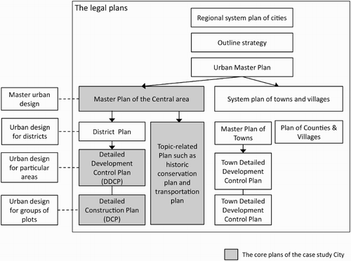
Table 1. Types of urban policies in China.
Urban design as public policy
From the perspective of political social economy, urban design in general deals with urban form with the aim of articulating various functions of a city in order to achieve its goals. It aims to ensure that the urban form represents the social meaning provided by a society's various actors in a changing process over time (Castells Citation1983). Urban design concerns a wide range of issues, summarized by Carmona et al. (Citation2003) into six dimensions — visual, morphological, functional, perceptual, social, and temporal dimensions — each of which is covered abundantly in literature. According to Madanipour (Citation2006), the significance of urban design also lies in its capability to address any new division of labour, shaping spaces, enhancing the competitiveness of cities, and managing change. To enhance its role in urban development, Barnett (Citation1974) advocated that urban design should be adopted as public policy to control urban development and to promote good building design as well as public space design. Since then, rich studies have explored the impact of design guidelines, and asked questions about the extent to which policies and practice cover sufficient design issues and meet intended design objectives (Hutchings Citation1989; Punter Citation2002; Carmona, Marshall, and Stevens Citation2006; Paterson Citation2012). This paper contributes to the literature by presenting an investigation of the Chinese experience of the design dimension of a comparatively young planning system.
Since the 1960s, urban researchers have proposed a range of design principles to achieve the general goals of sustainability and a sense of place. The earliest and most influential include Jacobs’ (Citation1961) promotion of mixed use and urban diversity, and Lynch's (Citation1981) principles of good urban form including vitality, sense, fit, access, and efficiency. Principles such as permeability, variety, legibility, robustness, visual appropriateness, richness, and personalization have been well illustrated in the popular book Responsive Environment (Bentley et al. Citation1985) and highlighted in Jacobs and Appleyard's (Citation1987) urban design manifesto. While empirical evidence is needed to prove whether these principles are applicable universally, specific strategies and means of delivering them within design policy can be demonstrated as being dramatically different in specific contexts.
Punter and Carmona (Citation1997) identified the key components of design policy, stating that these normally include objectives (i.e. statements of what a design should achieve to fulfil the general goals of a city or specific areas), design principles (which link these objectives with urban forms), and guidelines (which specify the methods needed to meet the objectives). Guidelines can be provided in one of the two formats: prescriptive guidelines (which outline specific layouts and dimensions of the end products of design), and performance guidelines (which stress the performance of design products rather than any particularities). These two guideline formats, respectively, refer to design codes and (diagrammatic and textual) design guides. Further advice, procedures, and implementation devices are often supplements of these key components (Punter and Carmona Citation1997).
In the British context, since the Urban Task Force (Citation1999) report, principles including character, continuity of enclosure, quality of public realm, ease of movement, legibility, adaptability, and diversity have been widely promoted and interpreted in various national design guides such as By Design (DETR Citation2000), Building for Life (Birkbeck and Kruczkowski Citation2012), Manual for Streets (Queen's Printer and Controller of HMSO Citation2007) and Urban Design Compendium (Llewelyn-Davies Citation2000). These have subsequently been interpreted in different types of local planning documentation, which is often performance-oriented and adopted in the form of supplementary planning documents focusing on either a particular area or a particular topic. In Europe, many states have adopted prescriptive design guidelines to exercise design control. For instance, in France a system of zoning has been established at the local level, and development is administrated by individual communes through the Plan d'Occupation des Sols (Kropf Citation1996). Here, land is divided into categories of zones, ranging from built or urban to unbuilt or natural, for which design codes are prepared accordingly. In the North American planning system, zoning and the associated design codes along with the statutory power are also a popular control mechanism for the delivery of design principles. The most well-known set of codes is the New Urbanists’ SmartCode (DPZ & Co Citation2007), which has been praised for its precision in control but criticized for its rigidness and failure to recognize localities. Design codes have also been tested in some pilot projects in the UK (Carmona, Marshall, and Stevens Citation2006).
Rather than performance-oriented design guides, prescriptive design codes may be more relevant for the Chinese context, given that the current Chinese planning framework has already emphasized in its plans the importance of controlled boundaries and development indices. This is explained in detail below.
Design principles and design elements of China's development control
Generally speaking, urban design deals with perceptual elements (townscapes, important views, and skylines), urban forms (density, building height, massing, scale, building type, urban grain, and sunlight), public spaces in relation to mixed use, crime and safety, accessibility, and public art (Punter and Carmona Citation1997). To understand the ways in which China's planning framework deals with design issues, it is important to examine the development objectives and principles adopted by planners and designers, and the design elements covered in the system. It is also essential to investigate the delivery mechanism of development control specified in the planning system.
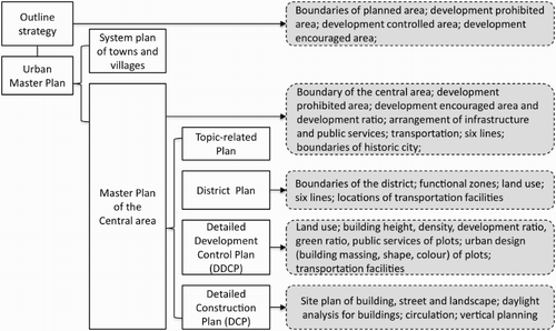
The 2008 Act states that the overriding goals of Chinese urban development are to coordinate urban and rural development, to facilitate sustainability through the compact arrangement of land, to preserve natural resources and heritage, to maintain local characteristics, and to balance population growth, public health and security (including readiness for disaster relief). Added to this, the Preservation Ordinance of Historic and Cultural Cities 2008 stresses the maintenance of traditional patterns, images, and scales. The intention of the Act is that these overriding objectives are followed in the formation of lower-level policies and plans which focus on specific design elements. The legal documents, namely the Urban Planning Formulation Method 2006 and the Implementation Details of the Formulation Method 2011 (the two will be referred to as the Method in the following text) specify certain compulsory design elements to be controlled at all levels of legal planning (see ). It is evident that at the large scale, the plans pay great attention to the delimitation of boundaries and land use, of which the former are highlighted by the so-called six lines (the red line represents the street line or site boundaries; the green line delineates the green system; the blue line, boundaries of water bodies; the purple line, boundaries of historic conservation areas; the yellow line, boundaries of public services; the black line indicating high voltage cables and radiation). These six lines ensure that the graphic representation of all legal plans is consistent and that the respective compulsory elements are considered. It may be fair to say that in China's planning framework, these six lines have effectively established a zoning system of development control, within which land use is allocated and sets of development conditions (or indices) are attached.
Figure 2. Elements for development control specified in the hierarchical plans.
In terms of the Chinese administrative procedures of development control, the core is the ‘one note and two permits’ system (i.e. the Permission Note for Location, the Land Use Planning Permit and the Building Permit). This was introduced by the 1989 Act and improved upon by the 2008 Act, with the local planning bureau playing a central role (). The 2008 Act extended the system to ‘one note and three permits’ by introducing the Village Land Use Planning Permit to control village development; this is currently at the core of the national ‘New Urbanisation’ policy (xinxing chengzhen hua), proposed by the State Council in late 2012.
Figure 3. Administrative procedure of development control.
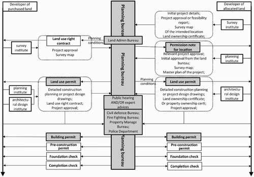
This core procedure reflects China's dual systems of land acquisition which were established through a series of land reforms in the 1980s, along with the marketization of previously state-owned or collective-owned land from the socialist era. Under the socialist planned economy, land was directly allocated for industrial development to state-owned work units which had full control over construction on the land. After land reform, in order to decentralize fiscal and planning power to local government while maintaining state ownership of urban land, the right to land use was separated from its ownership to be leased to developers through auction (Yeh Citation2005), with work units being gradually privatized from the 1980s onwards. However, marketization and privatization were not carried out consistently and as a result a dual system of land acquisition emerged: allocated lands controlled by work units co-existed with purchased lands. The administrative procedures of development control as regulated in the 2008 Act thus are different for the two types of land (see ). The 2008 Act stresses that proposals should be publicized to the public for at least a month and expert consultation enabled. This is an important step for the Chinese planning system towards developing an open approach (although current practice suggests that public opinion has little real impact on the implementation of proposals). Construction can begin if the Building Permit is granted. The planning bureau at this stage is still able to excise control through the Pre-construction Permit (optional), foundation check, and completion check, the details of which may vary in different cities.
The procedures explained above constitute an ideal situation, where the local planning bureau is in a relatively strong position in regards to decision-making. In reality, the power of planners is often compromised, if, for example, the demand of a particular area for development is high or the opinion of the city leader is strong. For instance, due to limited financial capacity, local governments have sometimes asked property developers for help with the provision of public infrastructure, and in return allocated urban land for the developers’ exclusive use (Po Citation2001). In such cases, developers have dominative power over the development. This has also happened in areas needing urgent regeneration, as evidenced in the redevelopment of the Taipingqiao area in Shanghai (Chen Citation2011). Furthermore, certain important decision-making is often dominated by political will (Leaf and Hou Citation2006; Chen and Thwaites Citation2013).
In recent years, control over important or large-scale development has become increasingly delivered through public–private partnerships. These enable local governments to retain some degree of power over the selection of appropriate developers and types of end users. They are also able to limit the profit made by developers on the construction and sale of public facilities. It means that a certain percentage of ownership of the development can be retained by government for public use. Exemplars include the Shenzhen Liuxian Dong area development and Shenzhen Sport Centre.
Case study: Nanjing's policies and plans
Nanjing is the capital city of Jiangsu Province. It enjoys more than 2,500 years of urban history and a strategic location within the Yangtze River delta, China's most developed east coast area, close to the megacity of Shanghai. In the last three decades, Nanjing has experienced rapid urbanization. In 1982, it was one of the primary listed historic and cultural cities in China, a title thus obtained because of its rich historic remains, mostly dating from the nineteenth and early twentieth centuries. Nanjing's recent strategy includes the aspiration of becoming an international city and competing regionally to attract both international and domestic investment. In particular, it aims to become a regional high-tech incubation hub and to develop a service-based economy. As the selected single case in this paper, Nanjing is not unique in its promotion of urban design. Rather, it is like other important regional capitals or centres in China (such as Shanghai, Suzhou, Beijing, Tianjin, Shenzhen) which have seen a dramatic increase of urban design practice in their development during the last decade. All design practice in China's cities is regulated by national policies and influenced by regional or local legislations.
Nanjing's planning system comprises local legislation, regulations, guidance, and technical standards, which have been established based on national regulations and the local context. The most important legislation is the Nanjing Urban and Rural Planning Ordinance (December 2012), accompanied by the Implementation Details of the Nanjing Urban Planning Ordinance. Other significant regulations are the Nanjing Historic and Cultural City Preservation Regulation (published December 2012) and the Formulation Method of Detailed Development Control Plans of Nanjing 2005, as well as various advices and notices announced by the municipal government and the planning bureau to facilitate specific planning aspects. Both Ordinances contain sections dedicated to the legal procedure of plan-making and modification, development control, monitoring and inspection, as well as the legal responsibilities of the parties involved. The general objectives of Nanjing's development as specified in the Ordinances are similar to those mentioned in the 2008 Act. In relation to design issues, the Preservation Regulation specifies height controls for the old city, the historic districts, axes, historic relics, visual corridors, mountains, and water in Nanjing. The Ordinances and the Preservation Regulation establish a five-tier local planning system for Nanjing.
Local legislation for urban design was not in place until 2013 when the municipal government published the Nanjing Urban Design Guide, or NUDG (draft version) along with the Nanjing Urban Public Space Design Guide. These two documents are complemented by the Nanjing Urban Design Representation Technical Standard (NUDRTS). Similar urban design policies have been produced recently governing cities such as Shenzhen, Tianjin, Fujian, Guiyang, or are being written (e.g. in Wuhan, Yangzhou, and Xi'an). Beijing, Ningbo, and Xiamen have published an urban design guide for specific city districts and urban elements. Nanjing as the case study city is thus not entirely unique among Chinese cities. In the NUDG, urban design is defined as the spatial arrangement and optimization of urban spaces based on the study of people, the environment, and the socio-economic conditions of the city. The policy states that design should be a comprehensive strategy for urban space, focusing on land use, morphology, transportation, and landscape in order to improve the city's efficiency and vitality. It also emphasizes that in Nanjing, urban central areas, waterfronts, mountain surroundings, transport hubs, and historic districts are important areas for urban design. The Notice on Strengthening Urban Design in Nanjing (2013) states that urban design needs to be conducted and attached as a development condition to all land auctioned. The effect of the policies on practice is, however, yet to be revealed.
The 14 urban design cases examined in this paper have all been released in digital format or as part of an exhibition for the purpose of public consultation (required by law before approval). Among about 100 design cases produced between 2009 and early 2013, these selected cases were considered significant enough by the planning bureau to be exhibited to the public. The aim was to inform the relevant legal plans (in particular the DDCPs and DCPs), enabling the latter to exercise development control. Their investigation would thus be likely to reveal the current status of urban design practice in the city, and the changing trend over recent years. The 14 cases, covering practice at the city level, district level and site level, respectively, include the master urban design of Nanjing which has been adopted in the master plan for Nanjing, the old southern city urban design for the preservation plan of the area, and 12 urban design projects for the high-tech incubation areas. Research data including plans, texts, and reports were collected from the local planning bureau. These data were originally used as part of a public consultation, and as a result not all was available. Furthermore, planning information related to underground infrastructure, and any elements relating to public security or the military had been removed. Despite the constraints this presents, the data formed an adequate basis for this research. It is not the intention here to investigate the implementation of these design cases in their construction, but to examine the extent to which urban design outcomes were adopted in legal plans, design principles followed, and design elements addressed for the purpose of development control.
The urban design section contained in the most recent Master Plan of Nanjing 2007–2030 (drawn up in 2009) shows the boundaries of height-controlled areas and the city's visual characteristics, including 18 visual corridors and 5 skylines as perceived from five specific locations on the periphery of the city. The plan also highlights historic nodes and urban gateways, three historic axes, ring roads, and expressways, all of which are considered by Lynch (Citation1960) to be perceptional urban elements and related to a city's visual identity. The master urban design aims to guide lower-tier plans.
The old southern city urban design and its preservation plan were devised by a Beijing-based design institute in November 2011 and approved by the local planning bureau in January 2012. Covering 5.56 sq km of land, the plan classified existing buildings in the area into four categories of preservation, repair, restoration, and adaptive reuse. In terms of design elements, the plan classified street facades into three categories, each with a different control strategy. A site plan was included to show the cultural tourism routes, nodes, land use, height control of buildings, and general street networks. This preservation plan and its urban design document aimed to inform the relevant DCPs of the area, of which Cangxiang-Anpin Neighborhood Detailed Construction Plan (2012) was one. Produced by a different design institute, this particular DCP inherited the building classifications of the southern city urban design document, but was more specific in terms of street width, building height, function, and roof styles of the neighbourhood development.
The additional 12 cases (the earliest case from 2009 and the most recent from April 2013) are listed in a chronological order in , which summarizes the design principles followed in each as well as the elements controlled in the relevant DDCPs. The last column shows the mismatch between urban design documents and the DDCPs. Among the cases, Zijin (Fangshan) () prepared by the Nanjing Jointhorp Architectural Office in April 2012 appears to be the first case which presents advancements in design where comparatively broad design elements were covered. The 1.82 sq km site is adjacent to the new campuses of several universities and colleges in the Jiangning District of Nanjing where intensive urbanization had been going on for the previous two decades. Agricultural land and villages had been rapidly built up with or replaced by real estate development and the campuses. The objectives of the project were to develop incubation centres for research into life science, medical instruments, and finance based on the surrounding educational facilities, and to accommodate new residents. Design principles (namely diversity, compact development, environmental sustainability, and encouraging public transport) were hinted at in the design statements on developmental structure (), functional zones, transportation, open spaces, city interfaces, and building height control. The site was divided into six management units for which specific urban design guides were assigned. These guides covered issues of height control, landscape, pedestrian and cycling systems, open spaces, interfaces, underground space, and plantations (). Building blocks and their possible arrangement for each unit were also illustrated, although the rationale for such suggestions was not explained (). The rendered images of the area ( and ) show buildings of an essentially international style with no emphasis on local identity, unlike in the master urban design of Nanjing. Compared to other, earlier selected cases, the design guide of this case is presented in a standard format. However, its design elements differed from those suggested in NUDRTS, which apparently was published a year later. Lacking in the design outcome was a context analysis of the site, meaning that the suggested forms were not justified, and that other than inclusion of the Fangshan mountain (a natural feature of the site) as a reference point for height control and development intensity (), the plan failed to reflect the characteristics of the surroundings. This was also a common problem found in the other cases. The site's DDCP approximately followed the developmental structure and functional zones of the land use map. The six lines reflected the height control and street system suggested in the urban design document. However, because of the rigid format of the legal plan, other elements were not transferred to the DDCP.
Figure 4. Master plan of the Zijin (Fangshan) urban design project.
Source: Nanjing Urban Planning Bureau, 2012.
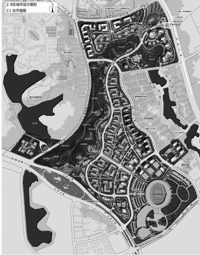
Figure 5. Developmental structure of the Zijin (Fangshan) urban design project serving as the concept that generates spatial arrangement.
Source: Nanjing Urban Planning Bureau, 2012.
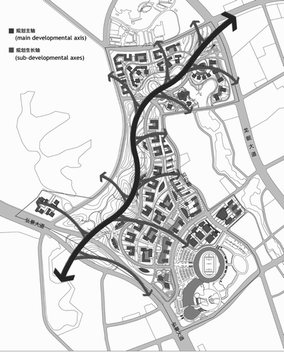
Figure 6. Design guide for one of the management units of the Zijin (Fangshan) urban design project showing design elements and content. The design elements (from left to right at the bottom of the figure) are height control, landscape, pedestrian and cycling system, open spaces, city interfaces, underground spaces, and plantation.
Source: Nanjing Urban Planning Bureau, 2012. Texts in the figure are translated by the author; details of design guide for each element are not translated.
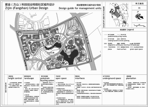
Figure 7. Design guide on spatial forms for the same management units as in in the Zijin (Fangshan) urban design project showing suggested and compulsory elements.
Source: Nanjing Urban Planning Bureau, 2012. Texts in the figure are translated by the author; details of design guide for each element are not translated.
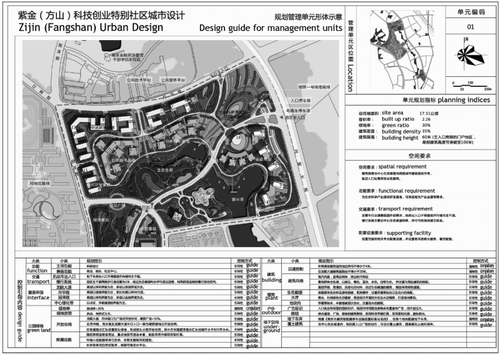
Figure 8. Bird's eye view of the Zijin (Fangshan) urban design project.
Source: Nanjing Urban Planning Bureau, 2012.
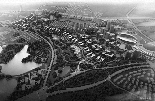
Figure 9. Street view of the Zijin (Fangshan) urban design project showing suggested buildings and landscape design.
Source: Nanjing Urban Planning Bureau, 2012.
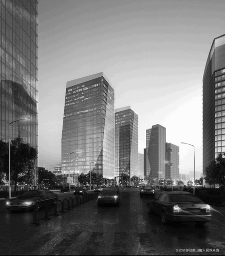
Figure 10. Concept diagram of the Zijin (Fangshan) urban design project showing height controls and development intensity in response to Fangshan Mountain.
Source: Nanjing Urban Planning Bureau, 2012.
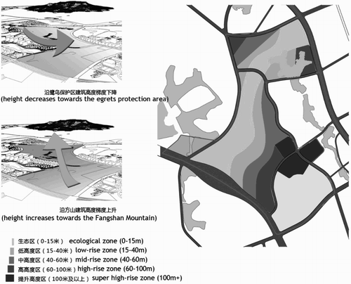
Table 2. Twelve case studies from Nanjing showing design principles and elements for development control in respective legal plans.
It is worth noting that for each case, the urban design and its DDCP were commissioned from the same design institute, which was not necessarily local. This study has identified a mismatch between the two in 10 of the 12 cases studied. Nevertheless, the local authorities’ determination to adopt urban design outcomes to the legal plans is evident. At the same time, design institutes from different parts of the country have varying capacities to deal with local contexts. Most of the cases cover four to six sq km of land; some, areas of two to eight sq km. These figures show the massive scale of plan-making and development in China, a factor which may have influenced the degree of detail in which urban design is able to engage. Furthermore, urban design principles specified by designers tend to be somewhat fluid; since 2011, principles such as mixed use, compact infrastructure/transportation networks and ecological conservation have been mentioned in the urban design outcomes. Cases conducted later in 2012 referred to the concept of transit-oriented development (TOD) (Dunphy Citation1995), encouragement of cycling and pedestrians, height control, qualities of the landscape and open spaces, robustness, and diversity. In terms of design content, the site plans of the earliest four cases only showed land use, while later cases included the street system and nodes. The most recent six cases included much broader coverage of design elements, specifically, skylines, building arrangements, landscape features, and streetscape; one case mentioned development phases. Three cases (Zijin (Fangshan) and two sites of the Jiangsu Software Development Park specified an urban design guide covering the building details of subdivided management units.
In terms of their respective DDCPs, all 14 cases followed the standard format as regulated in the Formulation Method 2005. Most included plot-specific indices in the standard table for land management which controls land use, area, built-up ratio, density, heights, green ratio, and vehicular entrances and exits. The indices were complemented by a plan indicating the six lines. There was no urban design guide in the first seven cases, either in textural format or as a graphic representation, although the Formulation Method claimed the inclusion of an urban design guide as early as 2005. Such a guide only appeared in the DDCPs of Zijin (Fangshan) and the latest three cases; all of these four guides were very brief. In most cases therefore, the implementation of urban design could hardly be said to have been ensured in the legal plans.
The majority of the 14 cases identify the mismatch between the notion of urban design and the relevant DDCPs. For instance, in the Xiaguan waterfront case, the division of plots in the urban design document differed from that in the DDCP, and the waterbody in the urban design document was not followed. In the Zijin (Jishan), Zijin (Jiangning), and Zijin (Lishui) cases, the transportation systems contained in the DDCPs were different from that shown in their respective urban design documents. In the Dongshan case, although the concept of TOD was adopted in the urban design document, it was not incorporated in the DDCP. In the Gaochun case, building heights were much higher in DDCP than those suggested in the urban design document.
Discussion
Since 2009, urban design has been increasingly conducted in Nanjing. Although urban design guides were not available here until late 2013, the local authority has been determined to promote urban design to help with the formation of legal plans. A master urban design was incorporated in the Master Plan of Nanjing, while urban design projects for the 12 sites were commissioned from the design institutes which also produced the relevant DDCPs. At the master plan level, reinforcing the city's identity was the priority; this was based essentially on the visual art tradition which dealt with viewing corridors, nodes, landmarks, urban fringes, and entrances. This concurs with Wu, Xu, and Yeh (Citation2007)’s argument that in China, urban design has been adopted by local governments and developers as place promotion or an image-building tool. In a neo-liberal context, this serves the purpose of enhancing a city's regional and international competitiveness. The aesthetic emphasis of urban design can also be seen from Nanjing's preservation plan and its relevant DCPs in the case study where building details were controlled in order to ensure consistency with historic images. Although aesthetic considerations were emphasized at the site level in all 12 cases, local identity in terms of context was not addressed. Furthermore, the quality of public spaces and coordinated development processes were almost neglected. The indication is that utilization of urban design as a tool for development control was limited.
The 12 cases demonstrate that urban design at the site level has been progressive, from a site plan design with a blueprint style in 2009 to one with a broadened coverage of design elements. However, in the absence of higher-level design goals or objectives for Nanjing, the design principles followed in all 12 cases varied greatly, and largely depended on the particular skills and experiences of specific designers. The urban design of the earlier cases specified no or very few principles, while later cases began to adopt principles supporting sustainability. Nevertheless, in none of the cases were the principles sufficiently justified in respect to the local context, nor sufficiently addressed as design outcomes.
The design content of each case varied and was mostly presented in graphic format with limited textural explanations. The outcomes were significantly inconsistent in terms of the level of detail; a factor likely to present difficulties in future implementation. However, it is interesting to note that in the Zijin (Fangshan) case and the two cases of the Jiangsu Software Development Park (which were prepared by different design institutes and comparatively the most recent), urban design outcomes in relation to management units were innovatively presented, using a standard format similar to that of the DDCPs (this was later promoted in the NUDRTS). Presumably the perceived advantages here were firstly to maintain consistency in design outcomes, and secondly to make it possible to attach the design outcomes as development conditions to each plot. However, it is not known whether the latter will be implemented, as development had not started on the 12 sites at the time of writing. Furthermore, the attempt to standardize urban design outcomes in the relevant design policy demonstrates an intention on the part of the policy-makers to make them prescriptive (like indices in DDCPs), and most likely for the purpose of easy management. Further empirical study is needed to monitor the effectiveness of this attempt in construction.
Clearly, DDCPs have been the main tool of development control. The standard elements which they cover — land use, the six lines and indices, as written in the national regulations — make the legal plans insufficiently flexible to incorporate urban design outcomes. Indeed, it is evident that in the 12 cases that the DDCPs and relevant urban design documents were mostly mismatched, despite having been produced by the same design institute. In each, the neglected quality of public spaces and coordinated development phases might also be attributed to the inflexibility of the DDCPs, which resulted in a regulated format unsuited to the delivery of detailed guides to elements such as plazas, parks, and playgrounds. In addition, the indices-oriented nature of the DDCPs has been criticized by many scholars as being insufficient to control actual development outcomes (Ng and Wu Citation1995; Yeh and Wu Citation1999; Huo Citation2002). Nevertheless, they continue to play an important role in the planning system because the indices can be easily followed and monitored by inexperienced Chinese planners unable to keep up with the rapid pace of urban development. The incompatibility of urban design and the DDCPs is perhaps one of the biggest challenges Chinese planning system currently faces.
Conclusion
To return to the research question, how then is urban design delivered through the institutional structure in China? The five-tier planning system has gradually incorporated urban design at each level. This has been legally enshrined in local regulations, but not in the relevant national law. The case studies show urban design to be particularly useful in specifying the characteristics of a city in its master plan in order to promote place identity, to control images in historic preservation areas, and to inform site-specific DDCPs. Ideally, once adopted in the legal plans, the controlled elements would become development conditions of land transaction and be monitored throughout the development process through the one note and three permits system. Current practice, however, suggests that urban design outcomes have only been partially achieved, due to the inconsistency of design principles and elements concerned in individual cases, and the heavily regulated DDCPs which cover only limited design elements. There may be other factors which have influenced the delivery of urban design (including leadership, and the relative positions of the regulator and developer involved in a particular development project) which have not been sufficiently discussed in this paper. There has moreover been a conflict in the delivery formats of urban design outcomes, in terms of whether they should be prescriptive or performance in nature; accommodating the latter type is a challenge for China's inherently prescriptive legal system. For a performance guide to function would need, for example, support from appropriately educated and experienced planners able to make cogent decisions about the granting of permits.
In relation to design elements and principles, national law and high-level local regulations have set general goals and objectives. However, the reflection of these in lower-level plans is limited. At the site level, for example, design elements and principles are inconsistent and depend on the skills and experience of designers. Sustainability-related principles (such as compact development, mixed use, diversity, and ecological conservation) are mentioned in the more recent of the selected cases; however, these tend not to be sufficiently justified and interpreted at the site level, where guidelines at city or regional level would be useful for providing an overall vision for development. The newly published NUDG and the Public Space Design Guide may fill this gap, and their effectiveness should be investigated in future research. Furthermore, it is necessary to call for an appropriate educational system in China. The current urban design programme is often offered in architectural schools, which means that a form- or aesthetic-oriented approach is favoured (Chen and Thwaites Citation2013). The general lack of input from disciplines such as sociology, geography, and economics limits the skills of planners and the vision needed to set up planning goals (Chen and Thwaites Citation2013). Furthermore, to maximize the employability of graduates in the hectic development market, China's current education programme often pays greatest attention to the technical skills of plan-making with respect to the operation of the current planning system, rather than ensuring critical engagement in the local context.
Limitations may exist in the case studies due to the partial availability of research data and the single policy context of Nanjing. Firstly, it is possible that some of the problems revealed in Nanjing have been tackled in the policies of other cities in China at the discretion of individual local authorities. However, the overall context of national policies and their prospective planning framework makes the single case study valid as a window on to the rapid progress of urban design practice. Secondly, the content analysis-based methodology used in this paper could be enriched by direct consultation with planners and urban designers to discuss individual cases. Nevertheless, from the evidence presented the author argues that to extend the arena of urban design in the context of China's urban development, not only does the link between urban design and legal plans need to be strengthened, but also the legal status of urban design in the planning system needs to be ensured. Moreover, urban design needs to be coordinated on a hierarchical scale for specific areas and topics. Design principles should be locally generated or justified and interpreted in relation to site conditions. Broad design elements need to be considered in development control. Further research should look at design practice in other Chinese cities where local legal environments may vary, in order to get the full picture of the current status of urban design in China. Finally, to extend the scope of this study (which focuses on the content of urban design and the transfer of design outcomes to legal plans), it would be useful to observe the development process of a particular site to understand the implementation of urban design documents and legal plans in construction.
Acknowledgements
The author thanks Nanjing Urban Planning Bureau for its assistance in data collection and kind permission to use figures taken from the Zijin (Fangshan) urban design project. Special thanks also go to the two anonymous reviewers for their constructive comments on the revision of this paper. The author appreciates Frances Hunt's suggestions on improving readability of this paper.
Disclosure statement
No potential conflict of interest was reported by the author.
References
- Abramson, D. B. 2007. “The Aesthetics of City-Scale Preservation Policy in Beijing.” Planning Perspectives 22 (2): 129–166. doi: 10.1080/02665430701213531
- Barnett, J. 1974. Urban Design as Public Policy: Practical Methods for Improving Cities. New York: McGraw-Hill.
- Bentley, I., A. Alcock, P. Murrain, S. McGlynn, and S. Smith. 1985. Responsive Environments: A Manual for Designers. London: The Architectural Press.
- Biddulph, M. 2011. “Urban Design, Regeneration and the Entrepreneurial City.” Progress in Planning 76 (2): 63–103. doi: 10.1016/j.progress.2011.08.001
- Birkbeck, D., and S. Kruczkowski. 2012. Building for Life: The Sign of a Good Place to Live. London: Building for Life Partnership.
- Carmona, M., T. Heath, T. Oc, and S. Tiesdell. 2003. Public Places, Urban Spaces: The Dimensions of Urban Design. Oxford: Architectural Press.
- Carmona, M., C. D. Magalhaes, M. Edwards, B. Awuor, and S. Aminossehe. 2013. The Value of Urban Design. Commission for Architecture and the Built Environment, Department of the Environment, Transport and the Regions, Kent.
- Carmona, M., S. Marshall, and Q. Stevens. 2006. “Design Codes: Their Use and Potential.” Progress In Planning 65 (4): 209–289. doi: 10.1016/j.progress.2006.03.008
- Castells, M. 1983. The City and the Grassroots: A Cross-cultural Theory of Urban Social Movements. Berkeley: University of California Press.
- Chen, F. 2011. “Traditional Architectural Forms in Market Oriented Chinese Cities: Place for Localities or Symbol of Culture?” Habitat International 35 (2): 410–418. doi: 10.1016/j.habitatint.2010.11.012
- Chen, F., and K. Thwaites. 2013. Chinese Urban Design: The Typomorphological Approach. Farnham: Ashgate.
- Cody, J. 1989. “ Henry K. Murphy: An American Architect in China, 1914-1935.” PhD thesis, Department of Architecture, Cornell University.
- Deng, Z. 2009. “Design Control in Post-reform China: A Case Study of Shenzhen's Commercial Office Development.” Urban Design International 14 (2): 118–136. doi: 10.1057/udi.2009.13
- DETR. 2000. By Design: Urban Design in the Planning System: Towards Better Practice, Commission for Architecture and the Built Environment. London: Thomas Telford.
- DPZ & Co. 2007. “SmartCode V9.0.” DPZ & Co. http://www.smartcodecentral.com/index.html.
- Dunphy, R. 1995. “ Transit-Oriented Development: Making a Difference?” Urban Land 54 (7): 32–48.
- Fang, C., and Y. Xie. 2008. “Site Planning and Guiding Principles of Hi-tech Parks in China: Shenzhen as a Case Study.” Environment and Planning B: Planning and Design 35 (1): 100–121. doi: 10.1068/b32064
- Hubbard, P. 1995. “Urban Design and Local Economic Development: A Case-Study in Birmingham.” Cities 12 (4): 243–251. doi: 10.1016/0264-2751(95)00041-J
- Huo, N. 2002. “ The Changing Role of Urban Design in China's Urban Development.” PhD thesis, Department of Environmental Planning, University of Strathclyde.
- Hutchings, A. 1989. “The Evolution of Urban Design as Planning Policy: The South Australian Experience.” Planning Perspectives 4 (2): 167–186. doi: 10.1080/02665438908725678
- Jacobs, J. 1961. The Death and Life of Great American Cities. New York: Vintage Books.
- Jacobs, A., and D. Appleyard. 1987. “Towards an Urban Design Manifesto.” Journal of American Planning Association 53 (1): 112–120. doi: 10.1080/01944368708976642
- Kropf, K. 1996. “An Alternative Approach to Zoning in France: Typology, Historical Character and Development Control.” European Planning Studies 4 (6): 717–737. doi: 10.1080/09654319608720376
- Leaf, M., and L. Hou. 2006. “The ‘Third Spring’ of Urban Planning in China: The Resurrection of Professional Planning in the Post-Mao Era.” China Information 20 (3): 553–585. doi: 10.1177/0920203X06070043
- Littlefield, D. 2009. Liverpool One: Remaking a City Centre. Chicester: Wiley.
- Llewelyn-Davies. 2000. Urban Design Compendium. London: English Partnerships and The Housing Corporation.
- Lynch, K. 1960. The Image of the City. Cambridge: The MIT Press.
- Lynch, K. 1981. Good City Form. Cambridge: MIT Press.
- Madanipour, A. 2006. “Roles and Challenges of Urban Design.” Journal of Urban Design 11 (2): 173–193. doi: 10.1080/13574800600644035
- Musgrove, C. D. 1999. “Building a Dream: Constructing a National Capital in Nanjing, 1927-1937.” In Remaking the Chinese City: Modernity and National Identity, 1900-1950, edited by J. W. Esherick, 139–160. Honolulu: University of Hawai'i Press.
- Ng, M. K., and F. Wu. 1995. “A Critique of the 1989 City Planning Act of the People's Republic of China.” Third World Planning Review 17 (3): 279–294. doi: 10.3828/twpr.17.3.rk1n81300k6t0g03
- Paterson, E. 2012. “Urban Design and the National Planning Policy Framework for England.” Urban Design International 17 (2): 144–155. doi: 10.1057/udi.2012.3
- Po, L.-C. 2001. “ Strategies of Urban Development in China's Reforms: Nanjing, 1984-2000.” PhD thesis, Department of City and Regional Planning, University of California.
- Punter, J. 2002. “Urban Design as Public Policy: Evaluating the Design Dimension of Vancouver's Planning System.” International Planning Studies 7 (4): 265–282. doi: 10.1080/1356347022000027710
- Punter, J. 2007. “Design-Led Regeneration? Evaluating the Design Outcomes of Cardiff Bay and Their Implications for Future Regeneration and Design.” Journal of Urban Design 12 (3): 375–405. doi: 10.1080/13574800701602510
- Punter, J. 2010. “Urban Design and the English Urban Renaissance 1999-2009: A Review and Preliminary Evaluation.” Journal of Urban Design 16 (1): 1–41. doi: 10.1080/13574809.2011.521007
- Punter, J., and M. Carmona. 1997. The Design Dimension of Planning: Theory, Content and Best Practice for Design Policies. London: E&FN Spon.
- Queen's Printer and Controller of HMSO. 2007. Manual for Streets. London: Thomas Telford.
- Tsin, M. 1999. “Canton Remapped.” In Remaking the Chinese City: Modernity and National Identity, 1900-1950, edited by J. W. Esherick, 19–29. Honolulu: University of Hawai'i Press.
- Urban Task Force. 1999. Towards a Strong Urban Renaissance. Urban Task Force.
- Wang, J. 2003. “ Guomin Zhengfu Shiqi Nanjing Shoudu Jihua Zhi Yanjiu [On the Capital Plan of Nanking in the Nationalist Era of China, 1928-1937].” PhD thesis, Department of Architecture, Guoli Chenggong University.
- Whitehand, J. W. R., K. Gu, S. M. Whitehand, and J. A. Zhang. 2011. “Urban Morphology and Conservation in China.” Cities 28 (2): 171–185. doi: 10.1016/j.cities.2010.12.001
- Wu, F. L. 2007. “Re-orientation of the City Plan: Strategic Planning and Design Competition in China.” Geoforum 38 (2): 379–392. doi: 10.1016/j.geoforum.2006.05.011
- Wu, F. L., J. Xu, and A. G.-O. Yeh. 2007. Urban Development in Post-reform China: State, Market and Space. London: Routledge.
- Xie, Y., and F. J. Costa. 1991. “Urban Design Practice in Socialist China.” Town Planning Review 13 (3): 277–296.
- Xie, Y., and F. J. Costa. 1993. “Urban Planning in Socialist China.” Cities 10 (2): 103–114. doi: 10.1016/0264-2751(93)90042-H
- Yeh, A. G.-O. 2005. “Dual Land Market and Internal Spatial Structure of Chinese Cities.” In Restructuring the Chinese City: Changing Society, Economy and Space, edited by L. J. C. Ma and F. L. Wu, 59–79. London: Routledge.
- Yeh, A. G.-O., and F. L. Wu. 1999. “The Transformation of the Urban Planning System in China from a Centrally-Planned to Transitional Economy.” Progress In Planning 51 (3): 167–252. doi: 10.1016/S0305-9006(98)00029-4