Abstract
The integration of GIS and multicriteria decision analysis has attracted significant interest over the last 15 years or so. This paper surveys the GIS‐based multicriteria decision analysis (GIS‐MCDA) approaches using a literature review and classification of articles from 1990 to 2004. An electronic search indicated that over 300 articles appeared in refereed journals. The paper provides taxonomy of those articles and identifies trends and developments in GIS‐MCDA.
Keywords:
1. Introduction
Spatial decision problems typically involve a large set of feasible alternatives and multiple, conflicting and incommensurate evaluation criteria. The alternatives are often evaluated by a number of individuals (decision‐makers, managers, stakeholders, interest groups). The individuals are typically characterized by unique preferences with respect to the relative importance of criteria on the basis of which the alternatives are evaluated. Accordingly, many spatial decision problems give rise to the GIS‐based multicriteria decision analysis (GIS‐MCDA). These two distinctive areas of research, GIS and MCDA, can benefit from each other (Laaribi et al. Citation1996, Malczewski Citation1999, Thill Citation1999, Chakhar and Martel Citation2003). On the one hand, GIS techniques and procedures have an important role to play in analyzing decision problems. Indeed, GIS is often recognized ‘as a decision support system involving the integration of spatially referenced data in a problem solving environment’ (Cowen Citation1988). On the other hand, MCDA provides a rich collection of techniques and procedures for structuring decision problems, and designing, evaluating and prioritizing alternative decisions. At the most rudimentary level, GIS‐MCDA can be thought of as a process that transforms and combines geographical data and value judgments (the decision‐maker's preferences) to obtain information for decision making. It is in the context of the synergetic capabilities of GIS and MCDA that one can see the benefit for advancing theoretical and applied research on GIS‐MCDA.
There is now a well‐established body of literature on GIS‐MCDA (e.g. Diamond and Wright Citation1988, Janssen and Rietveld Citation1990, Carver Citation1991, Church et al. Citation1992, Banai Citation1993, Pereira and Duckstein Citation1993, Eastman et al. Citation1995, Heywood et al. Citation1995, Jankowski Citation1995, Laaribi et al. Citation1996, Malczewski Citation1999, Thill Citation1999, Laaribi Citation2000, Chakhar and Martel Citation2003, Feick and Hall Citation2004). The main aim of the paper is to survey and classify the GIS‐MCDA articles published between 1990 and 2004. The remainder of this paper is organized into four sections. The methods used for surveying the GIS‐MCDA literature are discussed in the next section. Section 3 provides a general description of the GIS‐MCDA database. The articles are classified according to the various perspectives on GIS‐MCDA in section 4. Finally, section 5 presents concluding remarks.
2. Literature survey methods
The search for relevant publications was performed using several Web‐based scientific search engines, electronic libraries, and databases (see Appendix 1). The search was limited to articles published in refereed journals in the period between 1 January 1990 and 31 December 2004. It was done using a Boolean search containing the following terms: GIS and multicriteria (or multiobjective or multiattribute). Initially, any article containing the search terms was considered as a potential candidate for including into the database of the GIS‐MCDA publications.
To supplement the automated search, a manual search was also done. The manual procedure involved searching the reference sections of the papers identified by the automated search. Any relevant references within those papers were followed up on. Each article was reviewed by the author. Inclusion criteria for the review were any theoretical or applied work concerning an integration of the two methodologies or any presentation of a computer‐based system integrating the GIS and MCDA methods. Papers identified in the search, but that were clearly irrelevant, were omitted from further consideration, leaving 319 items that were reviewed thoroughly. A complete list of the papers is available at http://publish.uwo.ca/˜jmalczew/gis‐mcda.htm.
3. The GIS‐MCDM literature in 1990–2004
Figure shows the development of GIS‐MCDA in terms of the number of refereed articles published in 1990–2004 and the accumulation of those articles. The development of GIS‐MCDA has been modest in the first half of the 1990s. Of the 319 articles, there were only 26 papers (or 8.2% of the total) published between 1990 and 1995. While Carver (Citation1991) and Langevin et al. (Citation1991) are the earliest papers included in this survey, one should acknowledge that there had been GIS‐MCDA studies reported prior to 1991 in referred journals (e.g. Diamond and Wright Citation1988), book chapters (e.g. Janssen and Rietveld Citation1990), and conference proceedings (e.g. Moreno and Seigel Citation1988). It is interesting to note that while Carver (Citation1991) is one of the most widely cited GIS papers (see Fisher Citation2001), the work by Langevin et al. (Citation1991) remains largely unknown to the GIS community. The efforts to integrate GIS and MCDA in the late 1980s and early 1990s can be associated with the proliferation stage of the GIS development (see Waters Citation1998, Malczewski Citation2004). The proliferation phase was characterized by the development of the user‐oriented GIS technology, which has stimulated a wide range of GIS applications including the GIS‐based approaches for tackling spatial decision problems.
Figure 1. Total number of GIS‐MCDM articles per year for the period 1990–2004.
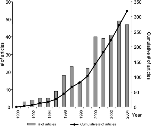
From 1995 to 2000 there has been a substantial acceleration in the number of the GIS‐MCDA articles published in refereed journals with the total number rising from 9 in 1995 to 40 in 2000. Over the last five years the volume of refereed publications on GIS‐MCDA has continued to grow very rapidly. Of the 319 articles, almost 70% were published in the last five years. The rapid increase of the volume of the GIS‐MCDA research can be attributed to a number of factors. First, a wider recognition of decision analysis and support as an essential element of GIScience (see the National Center for Geographic Information and Analysis (NCGIA) initiatives on ‘Spatial Decision Support Systems (SDSS)’, ‘Collaborative Spatial Decision Making’, ‘GIS and Society’, and the Varenius project on ‘Empowerment, Marginalisation and Public Participation GIS’ at http://www.ncgia.ucsb.edu/ncgia.html). Second, the availability of low‐cost and easy‐to‐use MCDA software such as Expert Choice (Expert Choice Inc.Citation1993) and mathematical programming solvers (e.g. LINDO Systems Inc. Citation1994). Third, the availability of MCDA modules in such systems as IDRISI (Eastman et al. Citation1993) and SPANS (TYDAC Research Inc. Citation1996), and TNT‐GIS (MicroImages Inc. Citation2001). In particular, the availability of a fully fledged decision support module in IDRISI has been instrumental for stimulating applied research in GIS‐MCDA (e.g. Pereira and Duckstein Citation1993, Aguilar‐Manjarrez and Ross Citation1995, Malczewski Citation1996, Brookes Citation1997, Tkach and Simonovic Citation1997, Giupponi et al. Citation1999, Jiang and Eastman Citation2000, Kyem Citation2001, Citation2004).
The diffusion of the GIS‐MCDA research is indicated by the large number and diversity of refereed journals serving as outlets for the GIS‐MCDM articles. Over the years, the articles have appeared in 135 different journals. The list of refereed journals known to have published GIS‐MCDA articles gives credence to GIS‐MCDA's vitality and acceptance (see table ). It also shows that GIS‐MCDA is a significant and relevant approach for a wide variety of fields (see section 4.4). The International Journal of Geographic Information Systems/Science leads with 21 publications (6.6%), followed by Landscape and Urban Planning with 14 publications (4.4%). Environment and Planning A/B comes up third with 12 (3.8%). Thus, the top three among 135 journals have published almost 15% of the GIS‐MCDA articles. The top six journals account for approximately 25% of all papers published, while the top 20 account for almost 50%. Alternately stated, approximately 5% of the journals have published more than a quarter of the papers, while about 15% of the journals account for almost half of all the GIS‐MCDA articles.
Table 1. The list of refereed journals that have published four or more articles on GIS‐MCDA in 1990–2004.
4. Classifications of the GIS‐MCDA articles
A number of approaches to structuring GIS‐MCDA have been suggested in the literature (Jankowski Citation1995, Malczewski Citation1999, Herwijnen and Rietveld Citation1999, Laaribi Citation2000, Chakhar and Martel Citation2003). Despite differences between the GIS‐MCDA frameworks, one can identify five generic components of the GIS‐based MCDA procedures: (i) a goal or a set of goals an individual (or a group of individuals) attempts to achieve along with associated evaluation criteria (objectives and/or attributes) on the basis of which the decision‐maker evaluates alternative courses of action; (ii) the decision‐maker or a group of decision‐makers involved in the decision‐making process along with their preferences; (iii) the set of decision alternatives (or the decision variables); (iv) the set of uncontrollable variables or states of nature (decision environment); and (v) the set of outcomes or consequences associated with each alternative‐criterion pair.
Given the generic components of GIS‐MCDA, two classification schemes for the GIS‐MCDA literature were developed. First, all articles were classified based on the geo‐information (GIS) components of the GIS‐MCDA methods. This classification involved the following considerations: (i) the geographical data models, (ii) the spatial dimension of the evaluation criteria, and (iii) the spatial definition of decision alternatives. Second, the articles were classified according to the generic elements of the MCDA methods. This taxonomy was based on (i) the nature of evaluation criteria, (ii) the number of individuals involved in the decision‐making process, and (iii) the nature of uncertainties. In addition, the articles were classified according to the extent and direction of the GIS and MCDA integration, and the type of application domain and decision problem.
4.1 The GIS components
The taxonomy of the geo‐information components of the GIS‐MCDA approaches is based on the following dichotomies: (i) the raster versus vector data models, (ii) explicitly spatial criteria versus implicitly spatial criteria, and (iii) explicitly spatial alternatives versus implicitly spatial alternatives.
4.1.1 The raster‐ and vector‐based GIS‐MCDA
Of the 319 papers, 152 (47.6%) articles reported the raster‐data‐based research (e.g. Pereira and Duckstein Citation1993, Eastman et al. Citation1995, Malczewski Citation1996, Cromley and Hanink Citation1999, Aerts et al. Citation2003, Church et al. Citation2003) and 150 (47.0%) articles discussed research involving the vector‐based GIS‐MCDA (e.g. Can Citation1992, Jankowski Citation1995, Laaribi et al. Citation1996, Rinner and Malczewski Citation2002, Feick and Hall Citation2004). There were 17 articles which did not provide any information on the geographical data model. It is important to note that some of the works reported in the GIS‐MCDA articles have been based on a combination of the raster and vector data models. It was, however, the geographical data structure used in the multicriteria combination rules (see section 4.2.1) that provided the bases for classifying the articles according to the geographical data model. Thus, if the combination rules were performed using the raster data, then the study was categorized as the raster‐based MCDA. Similarly, all papers reporting on the vector‐based multicriteria combination rules were categorized as the vector‐based multicriteria studies, irrespective of the format of the input data. Although the majority of the GIS‐MCDA research has been based on the layer view of the real‐world represented by the raster or vector data models, an effort has also been made to use the object‐oriented paradigm for integrating GIS and MCDA (e.g. Reitsma and Carron Citation1997, Matthews et al. Citation1999).
4.1.2 Explicitly and implicitly spatial criteria
The raster‐ and vector‐based GIS‐MCDA approaches are further subdivided into two categories depending on the nature of criteria. Criterion is a standard of judgment or rule on the basis of which alternative decisions can be evaluated and ordered according to their desirability (see section 4.2.1). Explicitly spatial criteria are present in the decision problems that involve spatial characteristics as criteria. For example, in the context of a site search problem such site characteristics as size, shape, contiguity, and compactness are explicitly spatial criteria (Brookes Citation1997, Church et al. Citation2003). Many decision problems involve criteria (objectives) which are implicitly spatial (Herwijnen and Rietveld Citation1999). A criterion is said to be implicitly spatial if spatial data are needed to compute the level of achievement of the criterion. Such criteria (objectives) as the gross marginal return of agricultural production, equity of income distribution, the public investment in the conservation reserve program, the costs of solid waste disposing, etc., can involve spatial attributes such as distance, proximity, accessibility, elevation, slope, etc. (e.g. MacDonald Citation1996, Antoine et al. Citation1997).
It should be noted that these two categories are not mutually exclusive (see table ). Indeed, the majority of the studies (almost 70%) involved both explicitly and implicitly spatial criteria (e.g. Kao and Lin Citation1996, Antoine et al. Citation1997, Lin et al. Citation1997, Seppelt and Voinov Citation2002, Martin et al. Citation2003, Wu et al. Citation2004). Of the 152 raster‐based GIS‐MCDA articles, 12 (7.9%) and 45 (29.6%) articles have reported research that involved explicitly and implicitly spatial criteria, respectively. Examples of the former category include: Eastman et al. (Citation1995), Brookes (Citation1997), Cromley and Hanink (Citation1999, Citation2003), Seppelt and Voinov (Citation2002), and Church et al. (Citation2003). The articles by Nevo and Garcia (Citation1996), Brakewood and Grasso (Citation2000), Fuller et al. (Citation2003), Perez et al. (Citation2003) and Store and Jokimäki (Citation2003) provide examples of the raster‐based implicitly spatial criteria. Similar classification for the vector‐based GIS‐MCDA showed that there were 20 (13.3%) articles reporting the use of explicitly spatial criteria (e.g. MacDonald Citation1996, Weigel and Cao Citation1999) and 12 (8.0%) studies involved implicitly spatial criteria (e.g. Vertinsky et al. Citation1994, Kächele and Dabbert Citation2002).
Table 2. Classification of the GIS‐MCDA articles according to the GIS data model and evaluation criterion.
4.1.3 Explicitly and implicitly spatial alternatives
Decision alternatives can be defined as alternative courses of action among which the decision‐maker must choose. A spatial decision alternative consists of at least two elements: action (what to do?) and location (where to do it?). The spatial component of a decision alternative can be specified explicitly or implicitly. Examples of explicitly spatial alternatives include: alternative sites for locating facilities (e.g. Aguilar‐Manjarrez and Ross Citation1995, Kao Citation1996, Basnet et al. Citation2001), alternative location‐allocation patterns (e.g. Armstrong et al. Citation1992, Cova and Church Citation2000, Malczewski et al. Citation1997), alternative patterns of land use‐suitability (e.g. Eastman et al. Citation1995, Antoine et al. Citation1997, Brookes Citation1997, Bennett et al. Citation1999). In many decision situations the spatial component of an alternative decision is not present explicitly. However, there may be a spatial implication associated with implementing an alternative decision. In such a case, the alternative is referred to as an implicitly spatial alternative (Herwijnen and Rietveld Citation1999). Spatially distributed impacts can emerge, for example, through the implementation of a particular solution to minimize flood risks in which favorable impacts are produced at one location while negative consequences result at another (Vertinsky et al. Citation1994, Tkach and Simonovic Citation1997, Jumppanen et al. Citation2003).
Table shows that the articles reporting on the use of explicitly spatial alternatives accounted for 57 or 37.5 % of all the raster‐based GIS‐MCDA papers (e.g. Ross et al. Citation1993, Kao Citation1996, Church et al. Citation2003). The implicitly spatial alternatives were used in 41 (or 27.0 %) articles on the raster‐based GIS‐MCDA (e.g. Jumppanen et al. Citation2003, Burton and Rosenbaum Citation2003, Wu et al. Citation2004). The GIS‐MCDA database contained 58 articles (38.7%) which have been categorized as the vector‐based GIS‐MCDA and explicitly spatial‐alternative category (e.g. MacDonald Citation1996, Weigel and Cao Citation1999, Armstrong et al. Citation2003). There were 49 (32.7%) articles in the vector‐based‐implicitly spatial‐alternative category (e.g. Vertinsky et al. Citation1994, Kächele and Dabbert Citation2002, Morari et al. Citation2004).
Table 3. Classification of the GIS‐MCDA articles according to the GIS data model and decision alternative.
4.2 The multicriteria decision analysis components
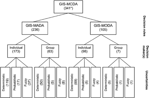
Given the generic elements of GIS‐MCDA, one can distinguish three dichotomies: (i) multiobjective decision analysis (MODA) versus multiattribute decision analysis (MADA), (ii) individual versus group decision‐making, and (iii) decisions under certainty versus decision under uncertainty (that is, the probabilistic and fuzzy decision‐making). This classification schema is shown in figure .
Figure 2. Classification scheme for the GIS‐MCDA articles (Note: the number of articles is given in brackets; *22 articles presented both GIS‐MADA and GIS‐MODA; these articles were included into the two categories).
4.2.1 Multiattribute and multiobjective decision analysis (MADA and MODA)
Criterion is a generic term including both the concept of attribute and objective. Thus, MCDA is used as the blanket term which includes both multiobjective and multiattribute decision‐making. The multiattribute decision problems are assumed to have a predetermined, limited number of alternatives. Solving this type of problem is a selection process as opposed to a design process. The multiobjective problem is continuous in the sense that the best solution may be found anywhere within the region of feasible solutions. Therefore, multiattribute and multiobjective problems are sometimes referred to as discrete and continuous decision problems, respectively (Hwang and Yoon Citation1981, Goicoechea et al. Citation1982).
Figure shows 341 GIS‐MCDA articles (approaches) at the top of the hierarchical classification. This number is greater then the number of surveyed articles, because there were 22 studies which combined the GIS‐MADA and GIS‐MODA methods (e.g. Guimarães Pereira et al. Citation1994, Vertinsky et al. Citation1994, Kao and Lin Citation1996, Bojórquez‐Tapia et al. Citation2001, Makropoulos et al. Citation2003). These articles were included in both the GIS‐MADA and GIS‐MODA categories. The results of the survey indicate that a majority of the articles fall into the GIS‐MADA category (figure ). The GIS‐MADA approaches account for almost 70% of the total (e.g. Banai Citation1993, Pereira and Duckstein Citation1993, Jankowski Citation1995, Eastman et al. Citation1995, Malczewski Citation1996, Feick and Hall Citation1999, Jun Citation2000, Kyem Citation2004). More than 30% of the approaches fall into the GIS‐MODA category (e.g. Xiang Citation1993, Antoine et al. Citation1997, Gomes and Lins Citation2002, Seppelt and Voinov Citation2002, Aerts and Heuvelink Citation2002, Aerts et al. Citation2003, Xiao et al. Citation2002, Armstrong et al. Citation2003, Kächele and Dabbert Citation2002, Stewart et al. Citation2004).
In addition to the classification of the articles into the GIS‐MADA and GIS‐MODA categories, it is useful to identify the algorithms or combination (decision) rules within each of the two groups. A decision rule is a procedure that allows for selecting one or more alternatives from a set of alternatives available to the decision‐maker (see Malczewski Citation1999). Although a considerable number of decision rules have been proposed in the MCDA literature (e.g. Cohon Citation1978, Hwang and Yoon Citation1981, Goicoechea et al. Citation1982), the use of the combination rules in the GIS‐MCDA studies has been limited to a few well‐known approaches such as the weighted summation, ideal/reference point, and outranking methods (see table ). The weighted summation and related procedures have been by far the most popular GIS‐MCDA approaches. These methods were present in 143 articles or 39.3% of the total (e.g. Eastman et al. Citation1995, Gumbricht et al. Citation1996, Pettit and Pullar Citation1999, Robinson et al. Citation2002, Ceballos‐Silva and López‐Blanco Citation2003, Perez et al. Citation2003, Ayalew et al. Citation2004, Marinoni Citation2004). The weighted summation has typically been used in conjunction with the Boolean operations (e.g. Eastman et al. Citation1995, Pettit and Pullar Citation1999, Perez et al. Citation2003). Many studies have used the weighted summation approach along with the linear transformation method for normalizing criteria and the pairwise comparison method for deriving the criterion weights (e.g. Eastman et al. Citation1995, Gumbricht Citation1996, Tseng et al. Citation2001, Basnet et al. Citation2001, Vlachopoulou et al. Citation2001, Wu et al. Citation2004, Marinoni Citation2004). The ordered weighted averaging (OWA) provides an extension and generalization of the Boolean operations and the weighted summation procedures. The OWA approach has been presented in Jiang and Eastman (Citation2000), Rinner and Malczewski (Citation2002), Makropoulos et al. (Citation2003), Malczewski et al. (Citation2003), and Rashed and Weeks (Citation2003).
Table 4. Classification of the GIS‐MCDA articles according to the combination rule.
The Analytical Hierarchy Process (AHP) is another popular method which is based on the additive weighting model (e.g. Banai Citation1993, Wu Citation1998, Basnet et al. Citation2001, Zhu and Dale Citation2001). The AHP method has been used in two distinctive ways within the GIS environment. First, it can be employed to derive the weights associated with attribute map layers. Then, the weights can be combined with the attribute map layers in a way similar to the weighted additive combination methods. This approach is of particular importance for problems involving a large number of alternatives, when it is impossible to perform a pairwise comparison of the alternatives (Eastman et al. Citation1993). Second, the AHP principle can be used to aggregate the priority for all level of the hierarchy structure including the level representing alternatives. In this case, a relatively small number of alternatives can be evaluated (Jankowski and Richard Citation1994).
The primary reason for the popularity of the weighted summation and related methods is that the approaches are very easy to implement within the GIS environment using map algebra operations and cartographic modeling. The methods are also easy‐to‐understand and intuitively appealing to decision‐makers. However, GIS implementations of the weighted summation procedures are often used without full understanding of the assumptions underlying this approach. In addition, the method is often applied without full insight into the meanings of two critical elements of the weighted summation model: the weights assigned to attribute maps and the procedures for deriving commensurate attribute maps. Hobbs (Citation1980), Lai and Hopkins (Citation1989), Heywood et al. (Citation1995) and Malczewski (Citation2000) provide discussions on some aspects of the incorrect use of the method.
Some of the difficulties associated with the weighted summation and AHP models can be avoided by using such MADA procedures as the ideal/reference point methods (Pereira and Duckstein Citation1993) and the outranking methods (Joerin et al. Citation2001). According to the survey (see table ), the ideal/reference point method is the second most often‐used GIS‐MADA combination rule (e.g. Carver Citation1991, Pereira and Duckstein Citation1993, Malczewski et al. Citation1997, Tkach and Simonovic Citation1997, Lee et al. Citation2000, Jankowski et al. Citation2001). Over the years a considerable number of articles have presented the use of the outranking methods such as ELECTRE and related procedures (e.g. Carver Citation1991, Can Citation1992, Joerin Citation1995, Villa et al. Citation1996, Joerin and Musy Citation2000, Joerin et al. Citation2001, Schlaepfer et al. Citation2002, Morari et al. Citation2004) and PROMETHEE (e.g. Laaribi et al. Citation1996, Martin et al. Citation2003).
The GIS‐MODA articles can be grouped into three main categories depending on the multiobjective algorithms: (i) multiobjective linear‐integer programming, (ii) goal programming/reference point algorithms, and (iii) heuristic search/evolutionary/genetic algorithms (table ). In general, the multiobjective models are often tackled by converting them to single objective problems and then by solving the problem using the standard linear‐integer programming methods (e.g. Cohon Citation1978, Goicoechea et al. Citation1982). This approach is the most often used in the GIS‐MODA research (e.g. Bowerman et al. Citation1995, Kao Citation1996, Cromley and Hanink Citation1999, Kächele and Dabbert Citation2002, Church et al. Citation2003). It accounts for 15.7% of all methods reported in the GIS‐MCDA articles (table ). Another group of GIS‐MODA includes articles in which the goal programming/reference point algorithms are used (e.g. Antoine et al. Citation1997, Chang et al. Citation1997, Grabaum and Meyer Citation1998, Agrell et al. Citation2004, Stewart et al. Citation2004). These traditional approaches to MODA have some limitations (Malczewski and Ogryczak Citation1996, Zhou and Civco Citation1996, Xiao et al. Citation2002, Aerts et al. Citation2003). First, they can be applied in situations when it is possible to formulate decision problems in terms of mathematical programming models. Second, the methods are of limited applicability for very large and complex problems. Third, the methods may fail to find important solutions. Given these limitations, a number of heuristics approaches have been proposed. Notably, the evolutionary/genetic algorithms have recently been applied for solving complex spatial problems (e.g. Guimarães Pereira et al. Citation1994; Zhou and Civco Citation1996, Balling et al. Citation1999, Bennett et al. Citation1999, Feng and Lin Citation1999, Matthews et al. Citation1999, Seppelt and Voinov Citation2002, Xiao et al. Citation2002, Armstrong et al. Citation2003).
4.2.2 Individual and group decision‐making
The GIS‐MADA and GIS‐MODA approaches can be further subdivided into two categories depending on the goal‐preference structure of the decision‐maker (see figure ). If there is a single goal‐preference structure, then the problem is referred to as a single decision‐maker's problem, regardless of the number of individuals actually involved. On the other hand, if individuals (interest groups) are characterized by different goal‐preference structures, then the problem becomes that of group decision‐making. The group decision‐making category includes the participatory decision making approaches (e.g. Jankowski and Nyerges Citation2001).
A majority of the GIS‐MCDA articles represented the individual decision‐maker's approaches (see figure and table ). These approaches were found in 63.8% of the GIS‐MADA articles (e.g. Carver Citation1991, Banai Citation1993, Pereira and Duckstein Citation1993, Eastman et al. Citation1995, Jun Citation2000) and 36.2% of the GIS‐MODA papers (e.g. Church et al. Citation1992, Xiang Citation1993, Kao Citation1996, Antoine et al. Citation1997, Kächele and Dabbert Citation2002, Aerts et al. Citation2003). The group/participatory approaches were presented in 70 articles (see figure and table ). They were found in 63 (90%) articles on GIS‐MADA (e.g. Malczewski Citation1996, Feick and Hall Citation1999, Citation2002, Jankowski et al. Citation1997, Citation2001, Qureshi and Harrison Citation2001, Kyem Citation2004). There were only seven papers in the GIS‐MODA‐group decision‐making category (e.g. Bennett et al. Citation1999, Seppelt and Voinov Citation2002, Bayliss et al. Citation2003).
Table 5. Classification of GIS‐MCDA papers according to the type of multicriteria decision method for individual decision maker.
Table 6. Classification of GIS‐MCDA papers according to the types of multicriteria decision methods for group decision‐making.
4.2.3 Decisions under condition of certainty and uncertainty
Broadly speaking, decision problems can be categorized into decisions under certainty and decisions under uncertainty depending on the amount of information (knowledge) about the decision situation that is available to the decision‐maker/analyst. If the decision‐maker has perfect knowledge of the decision environment, then the decision is made under conditions of certainty (deterministic decision‐making). Many real‐world decisions involve some aspects that are unknowable or very difficult to predict. This type of decision‐making is referred to as decisions under conditions of uncertainty. It should be recognized, however, that uncertainty may come from various sources. To this end, there are two basic types of uncertainty that may be present in a decision situation: (i) uncertainty associated with limited information about the decision situation, and (ii) uncertainty associated with fuzziness (imprecision) concerning the description of the semantic meaning of the events, phenomena or statements themselves. Consequently both multiattribute and multiobjective problems under uncertainty can be further subdivided into: probabilistic (stochastic) and fuzzy decision‐making problems depending on the type of uncertainty involved (see figure ).
Many analysts deliberately choose to model spatial decisions as occurring under a condition of certainty because of insufficient data or because the uncertainty is so remote that it can be disregarded as a factor (see Hwang and Yoon Citation1981, Malczewski Citation1999). Consequently, the majority of the GIS‐MCDA articles fall into the deterministic category. The deterministic approaches were presented in 263 papers or approximately 77% of the total (e.g. Carver Citation1991, Church et al. Citation1992, Jankowski and Richard Citation1994, Malczewski Citation1996, Brookes Citation1997, Aerts et al. Citation2003, Marinoni Citation2004). A vast majority of these articles belonged to the individual decision‐making category (see figure and tables and ). The articles presenting the research on the GIS‐MCDA under condition of uncertainty accounted for almost 23% of the total (e.g. Banai Citation1993, Klungboonkrong and Taylor Citation1998, Jiang and Eastman Citation2000, Noss et al. Citation2002, Seppelt and Voinov Citation2002, Rashed and Weeks Citation2003, Wang et al. Citation2004). Of the 78 articles on decision problems under condition of uncertainty, 35.9% fall into the probabilistic decision analysis category (e.g. Klungboonkrong and Taylor Citation1998, Noss et al. Citation2002, Seppelt and Voinov Citation2002, Wang et al. Citation2004) and 64.1% of the articles were found to represent the fuzzy decision‐making (e.g. Banai Citation1993, Martin et al. Citation2003, Jiang and Eastman Citation2000, Joerin et al. Citation2001, Makropoulos et al. Citation2003, Rashed and Weeks Citation2003).
4.3 Spatial Decision Support Systems (SDSS): integrating GIS and MCDA
The surveyed articles have been classified according to (i) the extent of integration, and (ii) the direction of integration of GIS and MCDA. Four categories have been identified based on the extent of integration: (i) no integration, (ii) loose coupling, (iii) tight coupling, and (iv) full integration (Goodchild et al. Citation1992, Nyerges Citation1992, Jankowski Citation1995, Malczewski Citation1999, Jun Citation2000). In the loose‐coupling approach, two systems (GIS and multicriteria modeling system) exchange files such that a system uses data from the other system as the input data. A tight‐coupling strategy is based on a single data or model manager and a common user interface. Thus, the two systems share not only the communication files but also a common user interface. A more complete integration can be achieved by creating user‐specified routines using generic programming languages. The routines can then be added to the existing set of commands or routines of the GIS package. This coupling strategy is referred to as a full integration approach.
The articles have also been classified in terms of the direction of integration. Five categories of articles have been identified: (i) no integration, (ii) one‐direction integration with GIS as principle software, (iii) one‐direction integration with MCDA system as principle software, (iv) bi‐directional integration, and (v) dynamic integration (see (Nyerges Citation1992, Jun Citation2000). One‐direction integration provides a mechanism for importing/exporting information via a single flow that originates either in the GIS or MCDA software. This type of integration can be based on GIS or MCDA as the principle software. In the bi‐directional integration approach the flow of data/information can originate and end in the GIS and MCDA modules. While bi‐directional integration involves one‐time flow of information, dynamic integration allows for a flexible moving of information back and forth between the GIS and MCDA modules according to the user's needs (Jun Citation2000).
Table shows a cross‐classification of the articles according to the extent and direction of GIS‐MCDA integration. It indicates that a considerable number of articles (26.0% of the total) do not provide any discussion on the integration of the two technologies (e.g. Balling et al. Citation1999, Noss et al. Citation2002). Of the 319 articles, 106 (33.2%) papers report the loose‐coupling approach (e.g. Guimarães Pereira et al. Citation1994, Jankowski Citation1995), and 95 (29.8%) articles discuss research involving the tight‐coupling approach (e.g. Bennett et al. Citation1999, Riedl et al. Citation2000). There are 35 (11.0%) articles presenting full integrated decision support systems (e.g. Eastman et al. Citation1995, Matthews et al. Citation1999). At the same time, almost half of the research has used GIS as the principle software for integrating MCDA and GIS (e.g. Jun Citation2000, Malczewski et al. Citation2003). The MCDA as the principle software strategy for integrating MCDA and GIS was used in 12.5% of the research (e.g. Antoine et al. Citation1997, Kächele and Dabbert Citation2002).
Table 7. Classification of the GIS‐MCDA articles according to the extent of integration and the direction of integration of GIS and MCDA.
4.4 Application domains and decision problems
One of the most remarkable features of the GIS‐MCDA approaches is the wide range of decision and management situations in which they have been applied over the last 15 years or so. Table shows a cross‐classification of the GIS‐MCDA articles according to the type of decision (and management) problems and application domain. Major application areas were found to be in environmental planning/ecology and management (e.g. Pereira and Duckstein Citation1993, Villa et al. Citation1996, Bojórquez‐Tapia et al. Citation2001, Qureshi and Harrison Citation2001, Noss et al. Citation2002, Seppelt and Voinov Citation2002, and Church et al. Citation2003), transportation (e.g. Church et al. Citation1992, Jankowski and Richard Citation1994, Bowerman et al. Citation1995, Weigel and Cao Citation1999, and Jha et al. Citation2001), urban and regional planning (e.g. Wu Citation1998, Feng and Lin Citation1999, Gomes and Lins Citation2002, and Ward et al. Citation2003), waste management (Carver Citation1991, Kao Citation1996, Kao and Lin Citation1996, MacDonald Citation1996, Charnpratheep et al. Citation1997, and Leão et al. Citation2004), hydrology and water resource (Langevin et al. Citation1991, Reitsma and Carron Citation1997, Tkach and Simonovic Citation1997, Giupponi et al. Citation1999, Lee et al. Citation2000, Makropoulos et al. Citation2003, Martin et al. Citation2003), agriculture (e.g. Matthews et al. Citation1999, Kächele and Dabbert Citation2002, Ceballos‐Silva and Lopez‐Blanco Citation2003, and Morari et al. Citation2004), and forestry (Vertinsky et al. Citation1994, Kangas et al. Citation2000, Riedl et al. Citation2000, Schlaepfer et al. Citation2002, Kyem Citation2004). These applications accounted for 72.4% of the total. The rest of the GIS‐MCDA applications were found in areas such as natural hazard management (e.g. Rashed and Weeks Citation2003, Ayalew et al. Citation2004), recreation and tourism management (e.g. Feick and Hall Citation1999, Citation2004), housing and real estate (e.g. Can Citation1992, Johnson Citation2001), geology and geomorphology (e.g. de Araújo and Macedo Citation2002, Burton and Rosenbaum (Citation2003), industrial facility management (e.g. Jun Citation2000, Vlachopoulou et al. Citation2001), and cartography (e.g. Huffman and Cromley Citation2002, Armstrong et al. Citation2003).
Table 8. Classification of the GIS‐MCDA articles according to the extent of integration and the application domain and decision problem.
The survey showed that the GIS‐MCDA approaches were most often used for tackling land suitability problems (table ). Almost 30% of the articles were concerned with land suitability analysis. This type of analysis was most frequently used in such application domains as: ecology and environment (e.g. Pereira and Duckstein Citation1993, Bojórquez‐Tapia et al. Citation2001), forestry (e.g. Riedl et al. Citation2000, Kyem Citation2004), agriculture (e.g. Ceballos‐Silva and Lopez‐Blanco Citation2003), waste management (e.g. Carver Citation1991, Charnpratheep et al. Citation1997), and natural hazard management (e.g. Rashed and Weeks Citation2003, Ayalew et al. Citation2004). Plan/scenario evaluation problems accounted for 15.4% of the total (e.g. Kangas et al. Citation2000, Martin et al. Citation2003). The types of problems were especially often tackled in the water resource application domain (e.g. Kächele and Dabbert Citation2002, Morari et al. Citation2004). In addition, the site search/selection problems (e.g. Aguilar‐Manjarrez and Ross Citation1995, Cova and Church Citation2000, Rinner and Malczewski Citation2002) and the resource allocation problems (e.g. Aerts and Heuvelink 2002, Aerts et al. Citation2003, Stewart et al. Citation2004) were found in a substantial portion of the GIS‐MCDA articles (approximately 14.5% and 11.0% of the total, respectively).
5. Conclusions
The last 15 years have evidenced remarkable progress in the quantity and quality of research in integrating GIS and MCDA. The multidisciplinary field of GIS‐MCDA has been widely and strongly adopted within the GIS community. Quite correctly, the GIS community recognizes the great benefits to be gained by incorporating MCDA into a suite of GIS capabilities. This survey suggests that GIS‐MCDA has generated a large enough literature allowing it to be considered as an essential subfield of research in GIScience. GIS‐MCDA has been vital in advancing GIScience in two major areas: spatial decision support and participatory GIS.
The efforts to integrate MCDA into GIS has been instrumental for developing the paradigm of spatial decision support (Goodchild Citation1993), in which the geographic information technology is made available directly to decision‐makers for policy or scenario development (Eastman et al. Citation1993, Malczewski Citation1999, Jankowski and Nyerges Citation2001, Ascough et al. Citation2002). The major advantage of incorporating MCDA techniques into GIS‐based procedures is that the decision‐makers can insert value judgments (their preferences with respect to evaluation criteria and/or alternatives) into GIS‐based decision‐making procedures, and receive feedback on their implications for policy evaluation. Such feedback can enhance the decision‐maker's confidence in the results, consistent with general findings in the decision support system literature on the importance of feedback (e.g. Limayem and DeSanctis Citation2000). MCDA provides mechanisms for revealing decision‐makers' preferences, and for identifying and exploring compromise alternatives. It can help users understand the results of GIS‐based decision‐making procedures, including tradeoffs among policy objectives, and use those results in a systematic, defensible way to develop policy recommendations.
The GIS‐MCDA research has made considerable contribution to the participatory GIScience (Jankowski and Nyerges Citation2001). By their nature, the MCDA approaches integrate multiple views of decision problems. They may improve communication and understanding among multiple decision‐makers and facilitate ways of building consensus and reaching policy compromises. Consequently, the GIS‐MCDA support systems have the potential to improve collaborative decision making process by providing a flexible problem‐solving environment where those involved in collaborative tasks can explore, understand, and redefine a decision problem (Feick and Hall Citation1999, Jankowski and Nyerges Citation2001, Kyem Citation2004). An integration of MCDA into GIS can support collaborative work by providing a tool for structuring group decision‐making problems and organizing communication in a group setting. MCDA provides a framework for handling the debate on the identification of components of a decision problem, organizing the elements into a hierarchical structure, understanding the relationships between components of the problem, and stimulating communication among participants.
The survey has revealed several problems, challenges and trends in the GIS‐MCDA research. They are related to the developments in geographic information technology and spatial analysis, as well as the developments in the area of conceptual and operational validation of the use of MCDA in real‐world spatial problems. The development of GIS‐MCDA has been paralleled by the evolution of geographic information technology. GIS systems have evolved from a ‘close’ expert‐oriented to an ‘open’ user‐oriented technology. This trend has stimulated a movement in the GIS community towards using the technology to increase the democratization of the decision‐making process via public participation. Malczewski (Citation2004) suggests that it is in the context of the debate on the interrelationship between GIS and society (Pickles Citation1995) that one can see the potential for advancing the role of GIS‐MCDA in the participatory GIScience. Specifically, GIS‐MCDA should be constructed with two perspectives in mind: the techno‐positivist perspective on GIS, and the socio‐political, participatory GIS perspective. It is expected that the trend towards advancing public participatory approach to GIS‐MCDA system design and application development will be of critical importance for a successful use of the GIS‐MCDA approaches in the real‐world decision situations (Jankowski and Nyerges Citation2001). Ascough et al. (Citation2002) suggest that the development of GIS‐MCDA must absorb new trends in geographical information technology including the Web‐based applications (e.g. Zhu and Dale Citation2001, Rinner and Malczewski Citation2002, Hossack et al. Citation2004, Sakamoto and Fukui Citation2004) and location‐based services. In the context of OpenGIS, the GIS‐MCDA approaches could be made available as services rather than systems (Rinner Citation2003). Preliminary efforts to integrate MCDA into the location‐based services have also been undertaken (e.g. Rinner and Raubal Citation2004).
Recent developments in spatial analysis show that geo‐computation (computational intelligence) offers new opportunities for GIS‐MCDA (Wu Citation1998, Zhou and Civco Citation1996, Bennett et al. Citation1999, Xiao et al. Citation2002). Geo‐computational tools can potentially help in modeling and describing complex systems for inference and decision‐making. An integration of MCDA and geo‐computation can enhance the GIS‐MCDA capabilities of handling larger and more diverse spatial data sets. Another significant trend has been associated with developing map‐centered‐exploratory approaches to GIS‐MCDA (Armstrong et al. Citation1992, Jankowski et al. Citation2001, Andrienko and Andrienko Citation2003). The main purpose of these approaches is to provide the decision‐maker with insights into the nature of spatial decision problems not readily obtained by conventional methods (such as tabular displays). The power of map‐centered‐exploratory analysis comes from the confidence in the GIS‐based MCDA procedures that grows as decision‐makers see the procedures confirm their understanding of the decision problem at hand.
The GIS‐MCDA research has tended to concentrate on the technical questions of integrating MCDA into GIS. As a consequence, our understanding of the benefits of such integration is limited by the lack of research on conceptual and operational validation of the use of MCDA in solving real‐world spatial problems. Very little empirical research has been undertaken to appreciate the dynamics of spatial decision making (Jankowski and Nyerges Citation2001). There are also other, more general, concerns surrounding the use of multicriteria decision methods in GIS that require careful consideration. In the MCDA community there has been much discussion focused on the theoretical foundations and operational validation of the MCDA methods (Bana e Costa et al. Citation1997). It is argued that some MCDA procedures are lacking a proper scientific foundation and some methods involve a set of stringent assumptions, which are difficult to substantiate in real‐world situations (e.g. Hobbs Citation1980, Hwang and Yoon Citation1981, Bana e Costa et al. Citation1997). To a large extent, these problems have been ignored by the GIS‐MCDA community. If a primary purpose of GIS‐MCDA is to process and synthesize a large number of value judgments and spatial data sets, and to examine the implications of those value judgments for planning and policy‐making, then more careful attention must be paid to the assumptions underlying the multicriteria procedures.
Acknowledgments
This research was supported by the GEOIDE Network (Project: HSS‐DSS‐17) of the Canadian Network of Centres of Excellence (Natural Science and Engineering Research Council of Canada, Social Science and Humanities Research Council of Canada, and Medical Research Council). The author would like to thank anonymous reviewers for their constructive comments on an earlier version of this paper.
Related Research Data
References
- Aerts , J. C. J. H. , Eisinger , E. , Heuvelink , G. B. M. and Stewart , T. J. 2003 . Using linear integer programming for multi‐site land‐use allocation. . Geographical Analysis , 35 : pp. 148 – 169 .
- Aerts , J. C. J. H. and Heuvelink , G. B. M. 2002 . Using simulated annealing for resource allocation. . International Journal of Geographical Information Science , 16 : pp. 571 – 587 .
- Agrell , P. J. , Stam , A. and Fischer , G. W. 2004 . Interactive multiobjective agro‐ecological land use planning: the Bungoma region in Kenya. . European Journal of Operational Research , 158 : pp. 194 – 217 .
- Aguilar‐Manjarrez , J. and Ross , L. G. 1995 . Geographical information system (GIS) environmental models for aquaculture development in Sinaloa State, Mexico. . Aquaculture International , 3 : pp. 103 – 115 .
- Andrienko , N. and Andrienko , G. 2003 . Informed spatial decisions through coordinated views. . Information Visualization , 2 : pp. 270 – 285 .
- Antoine , J. , Fischer , G. and Makowski , M. 1997 . Multiple criteria land use analysis. . Applied Mathematics and Computation , 83 : pp. 195 – 215 .
- Armstrong , M. P. , Densham , P. J. , Lolonis , P. and Rushton , G. 1992 . Cartographic displays to support locational decision‐making. . Cartography and Geographic Information Systems , 19 : pp. 154 – 164 .
- Armstrong , M. P. , Xiao , N. and Bennett , D. A. 2003 . Using genetic algorithms to create multicriteria class intervals for choropleth maps. . Annals of the Association of American Geographers , 93 : pp. 595 – 623 .
- Ascough II , J. C. , Rector , H. D. , Hoag , D. L. , McMaster , G. S. , Vandenberg , B. C. , Shaffer , M. J. , Weltz , M. A. and Ahjua , L. R. Multicriteria Spatial Decision Support Systems: overview, applications, and future research directions. In Proceedings of the International Environmental Modelling and Software Society, . 24–27 June 2002 , Lugano , Switzerland. pp. pp. 175 – 180 . Manno , , Switzerland : The International Environmental Modelling and Software Society .
- Ayalew , L. , Yamagishi , H. and Ugawa , N. 2004 . Landslide susceptibility mapping using GIS‐based weighted linear combination, the case in Tsugawa area of Agano River, Niigata Prefecture, Japan. . Landslides , 1 : pp. 73 – 81 .
- Balling , R. J. , Taber , J. T. , Brown , M. R. and Day , K. 1999 . Multiobjective urban planning using a genetic algorithm. . Journal of Urban Planning and Development , 125 : pp. 86 – 99 .
- Banai , R. 1993 . Fuzziness in geographical information systems: contribution from the analytic hierarchy process. . International Journal of Geographical Information Science , 7 : pp. 315 – 329 .
- Basnet , B. B. , Apan , A. A. and Raine , S. R. 2001 . Selecting suitable sites for animal waste application using a raster GIS. . Environmental Management , 28 : pp. 519 – 531 .
- Bana E Costa , C. A. , Stewart , T. J. and Vansnick , J. C. 1997 . Multicriteria decision analysis: some thoughts based on the tutorial and discussion sessions of the ESIGMA meetings. . European Journal of Operational Research , 99 : pp. 28 – 37 .
- Bayliss , J. , Helyar , A. , Lee , J. T. and S. Thompson , S. 2003 . A multi‐criteria targeting approach to neutral grassland conservation. . Journal of Environmental Management , 67 : pp. 145 – 160 .
- Bennett , D. A. , Wade , G. A. and Armstrong , M. P. 1999 . Exploring the solution space of semi‐structured geographical problems using genetic algorithms. . Transactions in GIS , 3 : pp. 51 – 71 .
- Bojórquez‐Tapia , L. A. , Diaz‐Mondragon , S. and Ezcurra , E. 2001 . GIS‐based approach for participatory decision making and land suitability assessment. . International Journal of Geographical Information Science , 15 : pp. 129 – 151 .
- Bowerman , R. , Hall , B. and Calamai , P. 1995 . A multi‐objective optimization approach to urban school bus routing: formulation and solution method. . Transportation Research Part A: Policy and Practice , 29 : pp. 107 – 123 .
- Brakewood , L. H. and Grasso , D. 2000 . Floating spatial domain averaging in surface soil remediation. . Environmental Science and Technology , 34 : pp. 3837 – 3842 .
- Brookes , C. J. 1997 . A parameterized region‐growing programme for site allocation on raster suitability maps. . International Journal of Geographical Information Systems , 11 : pp. 375 – 396 .
- Burton , C. L. and Rosenbaum , M. S. 2003 . Decision support to assist environmental sedimentology modelling. . Environmental Geology , 43 : pp. 457 – 465 .
- Can , A. 1992 . Residential quality assessment: alternative approaches using GIS. . The Annals of Regional Science , 23 : pp. 97 – 110 .
- Carver , S. J. 1991 . Integrating multi‐criteria evaluation with geographical information systems. . International Journal of Geographical Information Systems , 5 : pp. 321 – 339 .
- Ceballos‐Silva , A. and Lopez‐Blanco , J. 2003 . Delineation of suitable areas for crops using a multi‐criteria evaluation approach and land use/cover mapping: a case study in Central Mexico. . Agricultural Systems , 77 : pp. 117 – 136 .
- Chakhar , S. and Martel , J‐M. 2003 . Enhancing geographical information systems capabilities with multi‐criteria evaluation functions. . Journal of Geographic Information and Decision Analysis , 7 : pp. 47 – 71 .
- Chang , N‐B. , Lu , H. Y. and Wei , Y. L. 1997 . GIS technology for vehicle routing and scheduling in solid waste collection systems. . Journal of Environmental Engineering , 123 : pp. 901 – 910 .
- Charnpratheep , K. , Zhou , Q. and Garner , B. 1997 . Preliminary landfill site screening using fuzzy geographical information systems. . Waste Management and Research , 15 : pp. 197 – 215 .
- Church , R. L. , Loban , S. R. and Lombard , K. 1992 . An interface for exploring spatial alternatives for a corridor location problem. . Computers and Geosciences , 8 : pp. 1095 – 1105 .
- Church , R. L. , Gerrard , R. A. , Gilpin , M. and Stine , P. 2003 . Constructing cell‐based habitat patches useful in conservation planning. . Annals of the Association of American Geographers , 93 : pp. 814 – 827 .
- Cohon , J. L. 1978 . Multiobjective Programming and Planning. , London : Academic Press .
- Cova , T. J. and Church , R. L. 2000 . Contiguity constraints for single‐region site search problems. . Geographical Analysis , 32 : pp. 306 – 329 .
- Cowen , D. 1988 . GIS versus CAD versus DBMS: what are the differences. . Photogrammetric Engineering and Remote Sensing , 54 : pp. 1551 – 1555 .
- Cromley , R. G. and Hanink , D. M. 1999 . Coupling land use allocation models with raster GIS. . Journal of Geographical Systems , 1 : pp. 137 – 153 .
- Cromley , R. G. and Hanink , D. M. 2003 . Scale‐independent land‐use allocation modeling in raster GIS. . Cartography and Geographic Information Science , 30 : pp. 343 – 350 .
- de Araújo , C. C. and Macedo , A. B. 2002 . Multicriteria geologic data analysis for mineral favorability mapping: application to a metal sulphide mineralized area, Ribeira Valley Metallogenic Province, Brazil. . Natural Resources Research , 11 : pp. 29 – 43 .
- Diamond , J. T. and Wright , J. R. 1988 . Design of an integrated spatial information system for multiobjective land‐use planning. . Environment and Planning B , 15 : pp. 205 – 214 .
- Eastman , J. R. , Jin , W. , Kyem , P. A. K. and Toledano , J. 1995 . Raster procedures for multi‐criteria/multi‐objective decisions. . Photogrammetric Engineering and Remote Sensing , 61 : pp. 539 – 547 .
- Eastman , J. R. , Kyem , P. A. K. , Toledano , J. and Jin , W. 1993 . GIS and Decision Making. , Geneva : UNITAR .
- Expert Choice, Inc . 1993 . Expert Choice Version 8: User Manual. , McLean , VA : Decision Support Software, Inc. .
- Feick , R. D. and Hall , B. G. 1999 . Consensus‐building in a multi‐participant Spatial Decision Support System. . URISA Journal , 11 : pp. 17 – 23 .
- Feick , R. D. and Hall , B. G. 2002 . Balancing consensus and conflict with a GIS‐based multi‐participant, multi‐criteria decision support tool. . GeoJournal , 53 : pp. 391 – 406 .
- Feick , R. D. and Hall , B. G. 2004 . A method for examining the spatial dimension of multi‐criteria weight sensitivity. . International Journal of Geographical Information Science , 18 : pp. 815 – 840 .
- Feng , C‐M. and Lin , J‐J. 1999 . Using a genetic algorithm to generate alternative sketch maps for urban planning. . Computers, Environment and Urban Systems , 23 : pp. 91 – 108 .
- Fisher , P. 2001 . Citations to the International Journal of Geographical Information Systems and Science: the first 10 years. . International Journal of Geographical Information Science , 15 : pp. 1 – 6 .
- Fuller , D. O. , Williamson , R. , Jeffe , M. and James , D. 2003 . Multi‐criteria evaluation of safety and risks along transportation corridors on the Hopi Reservation. . Applied Geography , 23 : pp. 177 – 188 .
- Giupponi , C. , Eiselt , B. and Ghetti , P. F. 1999 . A multicriteria approach for mapping risks of agricultural pollution for water resources: the Venice Lagoon watershed case study. . Journal of Environmental Management , 56 : pp. 259 – 269 .
- Goicoechea , A. , Hansen , D. R. and Duckstein , L. 1982 . Multiobjective Decision Analysis with Engineering and Business Applications. , New York : John Wiley & Sons .
- Gomes , E. G. and Lins , M. P. E. 2002 . Integrating geographical information systems and multi‐criteria methods: a case study. . Annals of Operations Research , 116 : pp. 243 – 269 .
- Goodchild , M. 1993 . “ The state of GIS for environmental problem‐solving. ” . In Environmental modeling with GIS, , Edited by: Goodchild , M , Parks , B and Steyaert , L (Eds) . pp. 8 – 15 . Oxford : Oxford University Press . edited by
- Goodchild , M. F. , Haining , R. and Wise , S. 1992 . Integrating GIS and spatial data analysis: problems and possibilities. . International Journal of Geographical Information Systems , 6 : pp. 407 – 423 .
- Grabaum , R. and Meyer , B. C. 1998 . Multicriteria optimization of landscapes using GIS‐based functional assessments. . Landscape and Urban Planning , 43 : pp. 21 – 34 .
- Guimarães Pereira , A. , Munda , G. and Paruccini , M. 1994 . Generating alternatives for siting retail and service facilities using genetic algorithms and multiple criteria decision techniques. . Journal of Retailing and Consumer Services , 1 : pp. 40 – 47 .
- Gumbricht , T. , McCarthy , J. and Mahlander , C. 1996 . Digital interpretation and management of land cover—a case study of Cyprus. . Ecological Engineering , 6 : pp. 273 – 279 .
- Herwijnen , M. and van Rietveld , P. 1999 . “ Spatial dimensions in multicriteria analysis. ” . In Multicriteria Decision‐making and Analysis: A Geographic Information Sciences Approach, , Edited by: Thill , J‐C (Eds) . pp. 77 – 99 . New York : Ashgate . edited by
- Heywood , I. , Oliver , J. and Tomlinson , S. 1995 . “ Building an exploratory multi‐criteria modeling environment for spatial decision support. ” . In Innovations in GIS , Edited by: Fisher , P (Eds) . pp. 127 – 136 . Bristol : Taylor & Francis . 2, edited by
- Hobbs , B. F. 1980 . A comparison of weighting methods in power plant siting. . Decision Sciences , 11 : pp. 725 – 737 .
- Hossack , I. , Robertson , D. , Tucker , P. , Hursthouse , A. and Fyfe , C. 2004 . A GIS and Web‐based decision support tool for the management of urban soils. . Cybernetics and Systems , 35 : pp. 499 – 509 .
- Huffman , F. T. and Cromley , R. G. 2002 . An automated multi‐criteria cartographic aid for point annotation. . The Cartographic Journal , 39 : pp. 51 – 64 .
- Hwang , C‐L. and Yoon , K. 1981 . Multiple Attribute Decision Making: Methods and Applications. , Berlin : Springer‐Verlag .
- Jankowski , P. 1995 . Integrating geographical information systems and multiple criteria decision making methods. . International Journal of Geographical Information Systems , 9 : pp. 251 – 273 .
- Jankowski , P. , Andrienko , N. and Andrienko , G. 2001 . Map‐centred exploratory approach to multiple criteria spatial decision making. . International Journal of Geographical Information Science , 15 : pp. 101 – 127 .
- Jankowski , P. and Nyerges , T. 2001 . Geographic Information Systems for Group Decision Making: Towards a Participatory, Geographic Information Science. , New York : Taylor & Francis .
- Jankowski , P. , Nyerges , T. L. , Smith , A. , Moore , T. J. and Horvath , E. 1997 . Spatial group choice: a SDSS tool for collaborative spatial decision‐making. . International Journal of Geographical Information Systems , 11 : pp. 566 – 602 .
- Jankowski , P. and Richard , L. 1994 . Integration of GIS‐based suitability analysis and multicriteria evaluation in a spatial decision support system for route selection. . Environment and Planning B , 21 : pp. 326 – 339 .
- Janssen , R. and Rietveld , P. 1990 . “ Multicriteria analysis and geographical information systems: an application to agricultural land use in the Netherlands. ” . In Geographical Information Systems for Urban and Regional Planning, , Edited by: Scholten , H. J and Stillwell , J. C. H (Eds) . pp. 129 – 139 . Dordrecht : Kluwer Academic Publishers . edited by
- Jha , M. K. , McCall , C. and Schonfeld , P. 2001 . Using GIS, genetic algorithms, and visualization in highway development. . Computer‐Aided Civil and Infrastructure Engineering , 16 : pp. 399 – 414 .
- Jiang , H. and Eastman , J. R. 2000 . Application of fuzzy measures in multi‐criteria evaluation in GIS. . International Journal of Geographical Information Systems , 14 : pp. 173 – 184 .
- Joerin , F. 1995 . Méthode multicritère d'aide à la décision et SIG pour la recherche d'un site. . Revue Internationale de Géomatique , 5 : pp. 37 – 51 .
- Joerin , F. and Musy , A. 2000 . Land management with GIS and multicriteria analysis. . International Transactions in Operational Research , 7 : pp. 67 – 78 .
- Joerin , F. , Theriault , M. and Musy , A. 2001 . Using GIS and outranking multicriteria analysis for land‐use suitability assessment. . International Journal of Geographical Information Science , 15 : pp. 153 – 174 .
- Johnson , M. P. 2001 . Decision support for family relocation decisions under the Section 8 Housing Assistance Program using GIS and the Analytic Hierarchy Process. . Journal of Housing Research , 12 : pp. 277 – 306 .
- Jumppanen , J. , Kurttila , M. , Pukkala , T. and Uuttera , J. 2003 . Spatial harvest scheduling approach for areas involving multiple ownership. . Forest Policy and Economics , 5 : pp. 27 – 38 .
- Jun , C. 2000 . Design of an intelligent geographic information system for multi‐criteria site analysis. . URISA Journal , 12 : pp. 5 – 17 .
- Kächele , H. and Dabbert , S. 2002 . An economic approach for a better understanding of conflicts between farmers and nature conservationists—an application of the decision support system MODAM to the Lower Odra Valley National Park. . Agricultural Systems , 74 : pp. 241 – 255 .
- Kangas , J. , Store , R. , Leskinen , P. and Mehtätalo , L. 2000 . Improving the quality of landscape ecological forest planning by utilising advanced decision‐support tools. . Forest Ecology and Management , 132 : pp. 157 – 171 .
- Kao , J‐J. 1996 . A raster‐based C program for siting a landfill with optimal compactness. . Computers & Geosciences , 22 : pp. 837 – 847 .
- Kao , J. J. and Lin , H‐Y. 1996 . Multifactor spatial analysis for land siting. . Journal of Environmental Engineering , 122 : pp. 902 – 910 .
- Klungboonkrong , P. and Taylor , M. A. P. 1998 . A microcomputer‐based‐ system for multicriteria environmental impacts evaluation of urban road networks. . Computers, Environment and Urban Systems , 22 : pp. 425 – 446 .
- Kyem , P. A. K. 2001 . An application of a choice heuristic algorithm for managing land resource allocation problems involving multiple parties and conflicting interests. . Transactions in GIS , 5 : pp. 111 – 129 .
- Kyem , P. A. K. 2004 . On intractable conflicts and participatory GIS applications: the search for consensus amidst competing claims and institutional demands. . Annals of the Association of American Geographers , 94 : pp. 37 – 57 .
- Laaribi , A. 2000 . SIG et Analyse Multicitère. , Paris : Hermès Sciences Publications .
- Laaribi , A. , Chevallier , J. J. and Martel , J. M. 1996 . A spatial decision aid: a multicriterion evaluation approach. . Computers, Environment and Urban Systems , 20 : pp. 351 – 366 .
- Lai , S‐K. and Hopkins , L. D. 1989 . The meanings of trade‐offs in multiattribute evaluation methods: a comparison. . Environment and Planning B , 16 : pp. 155 – 170 .
- Langevin , C. , Pernel , F. and Pointet , T. 1991 . An aid to decision‐making in hydrogeological exploration: multicriterion analysts in the evaluation of aquifer potential in a fractured medium. . Hydrogeologie , 1 : pp. 51 – 64 . (in French)
- Leão , S. , Bishop , I. and Evans , D. 2004 . Spatial–temporal model for demand and allocation of waste landfills in growing urban regions. . Computers, Environment and Urban Systems , 28 : pp. 353 – 385 .
- Lee , Y. W. , Bogardi , I. and Kim , J. H. 2000 . Decision of water supply line under uncertainty. . Water Research , 34 : pp. 3371 – 3379 .
- Limayem , M. and DeSanctis , G. 2000 . Providing decisional guidance for multicriteria decision making in groups. . INFORMS , 11 : pp. 386 – 401 .
- Lin , H. , Wan , Q. , Li , X. , Chen , J. and Kong , Y. 1997 . GIS‐based multicriteria evaluation for investment environment. . Environment and Planning B , 24 : pp. 403 – 414 .
- LINDO Systems Inc. 1994 . What'sBest: User's Guide. , Chicago : LINDO Systems Inc. .
- MacDonald , M. L. 1996 . A multi‐attribute spatial decision support system for solid waste planning. . Computers, Environment and Urban Systems , 20 : pp. 1 – 17 .
- Makropoulos , C. K. , Butler , D. and Maksimovic , C. 2003 . Fuzzy logic spatial decision support system for urban water management. . Journal of Water Resources Planning and Management , 129 : pp. 69 – 77 .
- Malczewski , J. 1996 . A GIS‐based approach to multiple criteria group decision‐making. . International Journal of Geographical Information Systems , 10 : pp. 955 – 971 .
- Malczewski , J. 1999 . GIS and Multicriteria Decision Analysis. , New York : Wiley .
- Malczewski , J. 2000 . On the use of weighted linear combination method in GIS: common and best practice approaches. . Transactions in GIS , 4 : pp. 5 – 22 .
- Malczewski , J. 2004 . GIS‐based land‐use suitability analysis: a critical overview. . Progress in Planning , 62 : pp. 3 – 65 .
- Malczewski , J. and Ogryczak , W. 1996 . The multiple criteria location problem—Part 2: preference‐based methods and interactive decision support. . Environment and Planning A , 28 : pp. 69 – 98 .
- Malczewski , J. , Pazner , M. and Zaliwska , M. 1997 . GIS‐based techniques for visualizing multicriteria location analysis: a case study. . Cartography and Geographic Information Systems , 24 : pp. 80 – 90 .
- Malczewski , J. , Chapman , T. , Flegel , C. , Walters , D. , Shrubsole , D. and Healy , M. A. 2003 . GIS multicriteria evaluation with ordered weighted averaging (OWA): case study of developing watershed management strategies. . Environment and Planning A , 35 : pp. 1769 – 1784 .
- Marinoni , O. 2004 . Implementation of the analytical hierarchy process with VBA in ArcGIS. . Computers & Geosciences , 30 : pp. 637 – 646 .
- Martin , N. J. , St Onge , B. and Waaub , J. P. 2003 . An integrated decision aid system for the development of Saint Charles River alluvial plain, Quebec, Canada. . International Journal of Environment and Pollution , 12 : pp. 264 – 279 .
- Matthews , K. B. , Sibbald , A. R. and Craw , S. 1999 . Implementation of a spatial decision support system for rural land use planning: integrating geographic information system and environmental models with search and optimisation algorithms. . Computers and Electronics in Agriculture , 23 : pp. 9 – 26 .
- MicroImages Inc. 2001 . TNT‐GIS v. 6.50 Manual. , Lincoln , Nebraska : MicroImage, Inc. .
- Morari , F. , Lugato , E. and Borin , M. 2004 . An integrated non‐point source model‐GIS system for selecting criteria of best management practices in the Po Valley, North Italy. . Agriculture, Ecosystems and Environment , 102 : pp. 247 – 262 .
- Moreno , D. and Seigel , M. A GIS approach for corridor siting and environmental impact analysis. In GIS/LIS'88, Proceedings of the Third Annual International Conference, Exhibitions and Workshops, . November 30 – December 2 1998 , San Antonio , Texas. pp. pp. 507 – 514 . Falls Church , VA : American Congress on Surveying and Mapping .
- Nyerges , T. L. 1992 . “ Coupling GIS and Spatial Analytical Models. ” . In Proceedings of 5th International Symposium on Spatial Data Handling, , Edited by: Breshanan , P , Corwin , E and Cowen , D (Eds) . pp. 534 – 543 . Charleston , SC : Humanities and Social Sciences Computing Laboratory, University of South Carolina . edited by
- Nevo , A. and Garcia , L. 1996 . Spatial optimization of wildlife habitat. . Ecological Modelling , 91 : pp. 271 – 281 .
- Noss , R. F. , Carroll , C. , Vance‐Borland , K. and Wuerthner , G. 2002 . Multicriteria assessment of the irreplaceability and vulnerability of sites in the Greater Yellowstone ecosystem. . Conservation Biology , 16 : pp. 895 – 908 .
- Pereira , J. M. C. and Duckstein , L. 1993 . A multiple criteria decision‐making approach to GIS‐based land suitability evaluation. . International Journal of Geographical Information Systems , 7 : pp. 407 – 424 .
- Perez , O. M. , Telfer , T. C. and Ross , L. G. 2003 . Use of GIS‐based models for integrating and developing marine fish cages within the tourism industry in Tenerife (Canary Islands). . Coastal Management , 31 : pp. 355 – 366 .
- Pettit , C. and Pullar , D. 1999 . An integrated planning tool based upon multiple criteria evaluation of spatial information. . Computers, Environment and Urban Systems , 23 : pp. 339 – 357 .
- Pickles , J. 1995 . Ground Truth: The Social Implications of Geographic Information Systems, , New York : Guilford Press .
- Qureshi , M. E. and Harrison , S. R. 2001 . A decision support process to compare Riparian revegetation options in Scheu Creek catchment in North Queensland. . Journal of Environmental Management , 62 : pp. 101 – 112 .
- Rashed , T. and Weeks , J. 2003 . Assessing vulnerability to earthquake hazards through spatial multicriteria analysis of urban areas. . International Journal of Geographical Information Science , 17 : pp. 547 – 576 .
- Reitsma , R. F. and Carron , J. C. 1997 . Object‐oriented simulation and evaluation of river basin operations. . Journal of Geographic Information and Decision Analysis , 1 : pp. 10 – 24 .
- Riedl , L. , Vacik , H. and Kalasek , R. 2000 . MapModels: a new approach for spatial decision support in silvicultural decision making. . Computers and Electronics in Agriculture , 27 : pp. 407 – 412 .
- Rinner , C. 2003 . Web‐based spatial decision support: status and research directions. . Journal of Geographic Information and Decision Analysis , 7 : pp. 14 – 31 .
- Rinner , C. and Malczewski , J. 2002 . Web‐enabled spatial decision analysis using ordered weighted averaging. . Journal of Geographical Systems , 4 : pp. 385 – 403 .
- Rinner , C. and Raubal , M. 2004 . Personalized multi‐criteria decision strategies in location‐based decision support. . Journal of Geographic Information Science , 10 : pp. 149 – 156 .
- Robinson , T. P. , Harris , R. S. , Hopkins , J. S. and Williams , B. G. 2002 . An example of decision support for trypanosomiasis control using a geographical information system in eastern Zambia. . International Journal of Geographical Information Science , 16 : pp. 345 – 360 .
- Ross , L. G. , Mendoza , Q. M. E. A. and Beveridge , M. C. M. 1993 . The application of geographical information systems to site selection for coastal aquaculture: an example based on salmonid cage culture. . Aquaculture , 112 : pp. 165 – 178 .
- Sakamoto , A. and Fukui , H. 2004 . Development and application of a livable environment evaluation support system using Web GIS. . Journal of Geographical Systems , 6 : pp. 175 – 195 .
- Schlaepfer , R. , Iorgulescu , I. and Glenz , C. 2002 . Management of forested landscapes in mountain areas: an ecosystem‐based approach. . Forest Policy and Economics , 4 : pp. 89 – 99 .
- Seppelt , R. and Voinov , A. 2002 . Optimization methodology for land use patterns using spatially explicit landscape models. . Ecological Modelling , 151 : pp. 125 – 142 .
- Stewart , T. J. , Janssen , R. and van Herwijnen , M. 2004 . A genetic algorithm approach to multiobjective land use planning. . Computers & Operations Research , 31 : pp. 2293 – 2313 .
- Store , R. and Jokimäki , J. 2003 . A GIS‐based multi‐scale approach to habitat suitability modeling. . Ecological Modelling , 169 : pp. 1 – 15 .
- TYDAC Research Inc. 1996 . SPatial ANalysis Systeme, Version 6.0: User's Manual. , Nepean , Ontario : TYDAC Research Inc. .
- Thill , J‐C. 1999 . Multicriteria Decision‐making and Analysis: A Geographic Information Sciences Approach. , New York : Ashgate .
- Tkach , R. J. and Simonovic , S. P. 1997 . A new approach to multi‐criteria decision making in water resources. . Journal of Geographic Information and Decision Analysis , 1 : pp. 25 – 44 .
- Tseng , C. T. , Chen , S‐C. , Huang , C‐S. and Liu , C‐C. 2001 . GIS‐assisted site selection for artificial reefs. . Fisheries Science , 67 : pp. 1015 – 1022 .
- Vertinsky , I. , Brown , S. , Schreier , H. , Thompson , W. A. and van Kooten , G. C. 1994 . A hierarchical‐GIS‐based decision model for forest management: the systems approach. . INTERFACES , 24 : pp. 38 – 53 .
- Villa , F. , Ceroni , M. and Mazza , A. 1996 . A GIS‐based method for multi‐objective evaluation of park vegetation. . Landscape and Urban Planning , 35 : pp. 203 – 212 .
- Vlachopoulou , M. , Silleos , G. and Manthou , V. 2001 . Geographic information systems in warehouse site selection decisions. . International Journal of Production Economics , 71 : pp. 205 – 212 .
- Wang , X. , Yu , S. and Huang , G. H. 2004 . Land allocation based on integrated GIS‐optimization modeling at a watershed level. . Landscape and Urban Planning , 66 : pp. 61 – 74 .
- Waters , N. M. 1998 . “ Geographic information systems. ” . In Encyclopedia of Library and Information Science, , Edited by: Kent , A and Hall , C. M (Eds) . New York : Marcel Dekker . edited by
- Ward , D. P. , Murray , A. T. and Phinn , S. R. 2003 . Integrating spatial optimization and cellular automata for evaluating urban change. . The Annals of Regional Science , 37 : pp. 131 – 148 .
- Weigel , D. and Cao , B. 1999 . Applying GIS and OR techniques to solve Sears technician‐dispatching and home‐delivery problems. . INTERFACES , 29 : pp. 112 – 130 .
- Wu , F. 1998 . SimLand: a prototype to simulate land conversion through the integrated GIS and CA with AHP‐derived transition rules. . International Journal of Geographical Information Science , 12 : pp. 63 – 82 .
- Wu , Q. , Ye , S. , Wu , X. and Chen , P. 2004 . Risk assessment of earth fractures by constructing an intrinsic vulnerability map, a specific vulnerability map, and a hazard map, using Yuci City, Shanxi, China as an example. . Environmental Geology , 46 : pp. 104 – 112 .
- Xiang , W. 1993 . A GIS/MMP‐based coordination model and its application to distributed environmental planning. . Environment and Planning B , 20 : pp. 195 – 220 .
- Xiao , N. , Bennett , D. A. and Armstrong , M. P. 2002 . Using evolutionary algorithms to generate alternatives for multiobjective site‐search problems. . Environment and Planning A , 34 : pp. 639 – 656 .
- Zhou , J. and Civco , D. L. 1996 . Using genetic learning neural networks for spatial decision making in GIS. . Photogrammetric Engineering and Remote Sensing , 62 : pp. 1287 – 1295 .
- Zhu , X. and Dale , A. P. 2001 . JavaAHP: a Web‐based decision analysis tool for natural resource and environmental management. . EnvironmentalModelling and Software , 16 : pp. 251 – 262 .
Appendix 1
The following Web‐based electronic libraries and databases were searched for relevant articles:
IEEE Xplore® (http://ieeexplore.ieee.org/Xplore),
Ingenta (http://www.ingentaconnect.com),
Inspec® (http://www.engineeringvillage2.org),
ISI Web of Knowledge™ (http://isi10.isiknowledge.com),
Pion Publications Ltd. (http://www.pion.co.uk),
Project MUSE® (http://muse.jhu.edu),
ProQuest® (http://proquest.umi.com),
ResearchIndex (http://www.researchindex.com),
ScienceDirect® (http://www.sciencedirect.com),
Scirus (http://www.scirus.com),
Scopus™ (http://www.scopus.com/scopus/home.url),
SpringerLink (http://www.springerlink.com),
WorldCat® (http://firstsearch.oclc.org).