Abstract
Although being increasingly powerful in handling spatial data, geographical information systems (GIS) still lack the powerful functionality for process modeling in terms of simulation and optimization. This article discusses the concepts and methodologies of a geographical simulation and optimization system (GeoSOS). GeoSOS integrates cellular automata (CA), agent-based models (ABMs), and swarm intelligence models (SIMs) for solving process simulation and optimization problems. A general form of the so-called interaction rules is proposed for implementing this integrated system. The GeoSOS software is developed to provide these complementary functions that are unavailable in the current GIS. Experiments have demonstrated that GeoSOS is able to model the reciprocal relationships between urban simulation and spatial optimization (e.g., facility sitting, transport development, and natural protection) in fast-growing regions. Better modeling performances have been achieved using the coupling strategies of GeoSOS.
1. Introduction
Geographical information systems (GIS) provide the basic functions of capturing, storing, retrieving, manipulating, analyzing, displaying, and mapping of spatial data (Star and Estes Citation1990, Lo and Yeung Citation2002). Although these functions are important for solving a wide range of practical spatial analysis and decision-making problems, the data models and analysis methods of GIS provided are not rich enough in geographical concepts and understanding (Gahegan Citation1999). More importantly, the data models do not handle time well, nor do they capture functions or dynamic processes effectively (An et al. Citation2005). They have difficulties in simulating and analyzing the common geographical phenomena of self-organization, phase transition, and bifurcations (Batty and Xie Citation1994). Geographical processes, such as diffusion of disease, wildfire spread, ecological evolution, transport and residential development, urban dynamics, and land use changes, are usually very complex and often include nonlinear and emergence behaviors, stochastic components, and feedback loops over spatial and temporal scales.
There is a growing demand for building a toolbox of methods that can model and analyze a range of highly complex and often nondeterministic problems. An attempt to solve the existing modeling problems of GIS is to develop some bottom-up models. In the last three decades, a kind of urban cellular automata (CA) has been developed for simulating urban growth and land use dynamics (Batty and Xie Citation1994, Clarke et al. Citation1997, Li and Yeh Citation2000, Chen et al. Citation2002). Some of these CA models may include SLEUTH-CA (Clarke et al. Citation1997), multicriteria evaluation CA (MCE-CA) (Wu and Webster Citation1998), logistic-CA (Wu Citation2002), artificial neural network CA (ANN-CA) (Li and Yeh Citation2002b), and decision-tree CA (Li and Yeh Citation2004).
Another type of bottom-up approaches, agent-based models (ABMs), have attracted growing attention because they can well simulate complex natural systems that are influenced by both human and social factors (Torrens and Benenson Citation2005, Xie et al. Citation2007, Liu et al. Citation2010). ABMs provide a useful model framework to represent multistakeholders and catch the interactions among them. For example, Benenson (Citation1998) used a multiagent simulation model to simulate the population dynamics in a city, in which inhabitants can change their residential behavior depending on the properties of their neighbors and other global factors. This model is applied to the simulation of the ethnic residential distribution in the Yaffo area of Tel Aviv (Benenson et al. Citation2002). ABMs are also widely used within the field of resource management, such as fisheries management (Bousquet et al. Citation1993), agricultural land management (Dean et al. Citation2000), and forest management (Purnomo et al. Citation2005).
In ABMs, agents are usually modeled as social (real) spatial entities, such as residents, developers, and farmers. Recently, a group of swarm intelligence models (SIMs) has been developed in computer sciences. Swarm can be regarded as a special group of agents which only represents artificial animals (e.g., birds, fish, and ants) with simple intelligence. This type of agents is just used to solve a specific optimization problem through collective actions. One typical example is the use of artificial ants for solving optimization problems (Dorigo et al. Citation1996). Despite the simplicity of ant individuals, ant colonies present a highly structured social organization for completing complex tasks. Ant colony optimization (ACO) has been used to solve a variety of spatial optimization problems, such as traveling salesman problems (TSPs) (Dorigo and Gambardella Citation1997a, 1997b), data mining (Parpinelli et al. Citation2002), location and allocation (Sharma et al. Citation2006), sitting of service facilities (Liu et al. Citation2005, Li et al. Citation2009a), and capturing line features (Huang et al. Citation2006).
Bottom-up approaches have the advantages of analyzing and understanding many complex geographical phenomena (Batty and Xie Citation1994). However, these dynamic models, CA, ABMs, and SIMs, are basically isolated in the development and applications so far. It is desirable to establish a geographical simulation and optimization system (GeoSOS) which integrates these models within a unified framework. The challenge is a technical and implementational one. Some initial work has been done by considering collections of interacting geographic objects as geographic automata systems (GAS) (Torrens and Benenson Citation2005).
This article will continue such synthesis by discussing the concepts and methodologies for implementing a GeoSOS. GeoSOS will be developed based on the integration of various dynamic process models, such as CA, ABMs, and SIMs. Spatial microentities serve as the binding force for fusing these dynamic models into an integrated system. The development of these bottom-up toolboxes is to facilitate the modeling of land use dynamics and its reciprocal relationships with facility (point) siting, transport development, and natural protection. This type of integrated models should be useful for many planning applications in fast-growing regions. It is expected that the simulation models and optimization models can be mutually benefited from each other if they are built within a single platform.
2. GeoSOS
2.1. The concepts of GeoSOS
A GeoSOS is a computer-based system capable of simulating, predicting, optimizing, and displaying geographical patterns and processes. In this proposed system, the components of CA, ABMs, and SIMs are integrated under the interaction mechanisms of using spatial microentities. Spatial microentities, which are the basic elements of GeoSOS, include immovable cells of CA, social agents of ABMs, and animallike agents (e.g., insects or birds) of SIMs. Social agents are used to represent people or various organizations during urban and land use simulation. Animallike agents are used to represent artificial ants, fish, birds, and bees for completing spatial optimization tasks.
As the core of GeoSOS, a general form of the so-called interaction rules for representing this integrated GeoSOS is given as follows:
This set of interaction rules, which is used to reflect relationships between entities and their environment, determines the changes of the states, locations, and environment of GeoSOS. There are three subtypes of interaction rules of GeoSOS for these three components:
Explicitly focusing on physical factors, F CA represents the interaction rules (transition rules) of CA. Actually, the state conversion of CA is governed by a combined effect of various physical factors (e.g., neighboring land use types and proximities to various attraction centers). F ABMs reflects the interactions between social agents (people or various organizations) and their environment. Usually, urban and economic theories are used to define the behaviors of such agents (Li and Liu Citation2007). F SIMs addresses the interactions between animallike agents (ants, fishes, birds, bees, etc.) and their environment for formulating optimal solutions. Simple swarm intelligence can be used to guide the movement of such agents for solving various spatial optimization problems (Li et al. Citation2009a, Citation2009b).
CA and ABMs can be combined together to deal with both physical and human factors for modeling complex geographical processes more effectively. The reason is that neither CA nor ABMs are efficient for modeling complex natural systems when they are used in isolation (Torrens and Benenson Citation2005). Recently, ABMs have attracted more attention than CA because the former have the flexibility of representing various players in shaping geographical phenomena. However, CA are still an important tool for geographical simulation because of their unique features. First, the implementation of CA is easier because of using much simpler model structures. Second, CA are less data demanding and have the ability to provide predictive results with less data. It is easy to define, calculate, and update the physical factors that govern the state conversion of CA using GIS functions. CA could be the only choice when the region to be simulated is very large, or social and economic data are missing. CA can implicitly represent the interactions between social actors and their environments in shaping natural systems just through the proxies of physical variables. Third, CA can be well calibrated by a number of techniques, such as logistic regression (Wu Citation2002), ANN (Li and Yeh Citation2002b), and machine learning (Li and Yeh Citation2004).
The strict distinction may be debatable between CA, ABMs, and SIMs. One may argue that a special case of ABMs equal to a CA can be created by fixing the agents in ABMs. Under such situation, the fixed agents can represent immovable cells of CA. Moreover, ABMs and SIMs are also similar because they are all agent based. In this study, however, these three types of dynamic models are distinguished because they adopt quite different sets of interaction rules and have different characteristics as described in Section 2.2.
GeoSOS may be implemented according to the following five steps of operations: (1) mining and defining the interaction rules according to domain knowledge or local experiences; (2) obtaining the initial conditions, such as the states and the environment; (3) running the simulation and optimization by applying these interaction rules; (4) updating the states, locations, and environment by iterations; and (5) coupling the simulation with the optimization.
These operations can be conceptualized using the following equations:
The novelty of this integrated system is that the optimization results can be used as the inputs to the simulation models and vice versa. This can be done by replacing the simulated pattern with the optimized one or the optimized pattern with the simulated one at time T on the right-hand side of EquationEquations (6)(6) and (7), respectively:
Defining the interaction rules is the core of implementing GeoSOS. Some knowledge discovery tools (M) can help obtain these rules (F CA, F ABMs, F SIMs) using training data (D). These training data are usually retrieved from remote sensing and GIS datasets. The objective is to minimize the difference between the simulated patterns and the actual ones. This can be based on the so-called trial-and-error approach (Clarke et al. Citation1997, Ward et al. Citation2000). The validation of simulated patterns is usually through a map comparison process. One simple map comparison method is to overlap a simulated pattern with the actual one (actual land use map or classified remote sensing image) cell-by-cell, and a consequent contingency table will provide the information about the fitness of these two patterns. Pontius and Schneider (Citation2001) suggested the use of the relative operating characteristic (ROC), which is derived from this contingency table, to validate simulation models.
The cell-by-cell overlay is popular but the major weakness is that it ignores the spatial structures (Sui and Zeng Citation2001, Hagen-Zanker Citation2006). However, this approach can allow CA to be automatically calibrated by some data mining tools, such as computer search (Clarke and Gaydos Citation1998), logistic regression (Wu Citation2002), neural networks (Li and Yeh Citation2002b), and decision trees (Li and Yeh Citation2004).
2.2. Mining and defining interaction rules for GeoSOS
2.2.1. The interaction rules of CA
The process for acquiring transition rules (parameters) of CA is usually very tedious and time-consuming. GeoSOS addresses this problem by providing some useful tools to determine the parameters of CA. At this stage, GeoSOS can define the interaction rules of CA in a number of ways, such as MCE (Wu and Webster Citation1998), logistic regression (Wu Citation2002), principal components analysis (PCA) (Li and Yeh Citation2002a), ANN (Li and Yeh Citation2002b), and decision trees (Li and Yeh Citation2004).
MCE is a straightforward method for defining the transition rules of CA using a series of physical factors (e.g., various distances to attraction centers). This method can be implemented by a nonlinear transformation of a composite evaluation score (Wu and Webster Citation1998):
The composite evaluation score (z i ) is calculated based on a linear combination (Wu and Webster Citation1998):
This MCE method cannot be calibrated because land development is a binary (developed or not) variable. A modification to this MCE method is to use a logistic form to represent the probability so that the calibration is possible (Wu Citation2002, Li et al. Citation2008). The final development probability is estimated as follows:
The ANN-CA method also provides a convenient calibration procedure (Li and Yeh Citation2002b). ANN-CA has the inherent black-box feature because the effects of each spatial variable are not transparent to the users. However, this model is quite convenient for calibration and implementation. Another advantage is that this model is straightforward for simulating multiple land use dynamics (Li and Yeh Citation2002b).
2.2.2. The interaction rules of ABMs
ABMs explain emergent higher level phenomena by tracking the actions of multiple low-level agents (Janssen and Ostrom Citation2006, Robinson et al. Citation2007). A major problem is how to calibrate ABMs because there are no general model structures for representing agents' behaviors. It is difficult to examine the complex manner in which the accumulation of individual decisions, as affected by social/political factors and economic conditions, may affect the biophysical environment across a range of spatial and temporal scales (An et al. Citation2005).
Therefore, ABMs have much more diversified forms of interaction rules than CA. Agents' behaviors cannot be easily captured because they are affected by various social and economic factors, which are associated with a lot of uncertainties. In most situations, economic and urban theories provide the guide for defining their behaviors heuristically. For example, urban dynamics may be simulated according to the interactions between several types of agents, such as urban residents, governments, and developers based on urban theories (Benenson et al. Citation2002, Li and Liu Citation2007, Xie et al. Citation2007).
Some initial work has been carried out on defining the interaction rules of ABMs more effectively. An operational procedure is proposed to determine some of the parameters for ABMs using MCE techniques (Li and Liu Citation2007). An agent will select a site by maximizing the utility function as much as possible. The utility function consists of two parts, site attributes and agents' status. This function is a linear-weighted combination of various spatial factors (site attributes). The weight associated with a spatial factor is determined by the social and economic status of agents. This framework provides a convenient way to deal with physical, social, and economic factors for implementing ABMs. The utility function for selecting cell i can be defined as follows:
2.2.3. The interaction rules of SIMs
An important feature of GeoSOS is its capability of solving spatial optimization problems according to ACO techniques. Traditionally, ACO has been used to solve the TSP (Dorigo et al. Citation1996). By modifying traditional ACO, GeoSOS provides three types of ACO modules: (1) facility siting (Li et al. Citation2009a), (2) path finding (Li et al. Citation2009b), and (3) area optimization.
First, the facility siting ACO algorithm is developed to identify the optimal locations for siting N point facilities according to the pheromone updating of artificial ants. The spatial search is based on the selection (visit) probability related to the trail density and the visibility (distance). According to traditional ACO, the probability that a cell i is selected for sitting a facility by the kth ant at time t is modified as follows (Li et al. Citation2009a):
The optimal spatial search is implemented by a feedback mechanism. A heuristic function is defined to obtain better convergence rates during the iterations of spatial search. It is assumed that a selected site should cover the population in the neighborhood as large as possible. This can minimize the total transportation cost. Therefore, the heuristic function is defined as follows:
At each iteration t, the trail density is updated according to the following feedback mechanism (Dorigo et al. Citation1996):
A crucial step is to incorporate a utility function within the standard ACO for estimating :
The utility function is application dependent. In many situations, the objective is to minimize the total transport cost for optimal facility siting. This utility is then represented by the inverse of the total transport cost of N facilities:
Second, artificial ants with simple swarm intelligence can also be used to determine the best paths for constructing subways, highways, and pipelines. The optimization is often implemented on raster surfaces for solving practical problems. A number of objectives, such as the minimum total travel distance and maximum service coverage, could be incorporated into the optimization model. The formation of an optimal path under such situations is a hard combinatorial optimization problem.
The standard ACO can also be modified to solve such optimal path-finding problems. During ants' walking, there are eight direct neighboring cells (ν
i
) for a central cell (c) on a raster surface. These eight neighbors are represented by ν1, ν2, ν3, ν4, ν5, ν6, ν7, and ν8 for eight possible moving directions. There are infinite combinations of the walking schemes by forming a path between an origin and a destination. An ant could move randomly without finding optimal paths based on conventional ant algorithms. For better convergence, the traditional heuristic function for visibility is replaced by a more sophisticated direction function []. The transition probability from a central cell to a neighboring cell is given as follows (Li et al. Citation2009b):
The same feedback mechanism as described in Equation16–18) is used to complete the path formation. However, the utility in EquationEquation (18)
(18) should be modified to address these two conflicting objectives, the maximum service (population) coverage and the minimum travel distance, during path finding. The utility function is given as follows:
Third, ACO is further modified for solving area optimization problems, such as the formation of natural protected areas. This type of optimization problems usually involves two major components: (1) suitability and (2) contiguity constraints. The same EquationEquation (14)(14) can be used to calculate the probability of selecting cell i for forming the natural protected areas. However, the utility
in EquationEquation (18)
(18) should be modified to address the factors of suitability and contiguity constraints. This function is given according to a linear combination of these two objectives:
2.3. Integration of CA, ABMs, and SIMs
2.3.1. Integration of CA and ABMs
In this study, the integration of CA and ABMs is based on the strategy of joint probability. It is implemented using two procedures: (1) estimating the separate probability of state conversion using CA and ABMs, respectively; and (2) calculating the joint probability according to these two probabilities. These procedures are illustrated using the example of simulating residential development.
First, the development probability of CA, , is estimated according to EquationEquation (12)
(12). The development probability related to ABMs can be based on the utility function of EquationEquation (13)
(13). For resident k, the probability of cell i to be selected is equal to the utility probability that the utility value at that location is greater than or equal to those at other locations (McFadden Citation1978):
The final decision is made according to the interactions between government agents, resident agents, developer agents, and the environment. Thus, a final joint probability for residential development at a cell is obtained by combining various probabilities from the CA component and the ABMs component (Li and Liu Citation2007):
2.3.2. Coupling CA with SIMs
GeoSOS provides a platform that the simulation module can be dependent on the optimization module and vice versa. More effective simulation and optimization tasks may be accomplished under this coupling framework. There are two types of coupling methods – loose coupling and tight coupling. Loose coupling means that one module interacts with another module through a stable interface and does not need to be concerned with the other module's internal implementation. This coupling is convenient because a change in one module will not require a change in the implementation of another module. With tight coupling, however, change in one module forces a ripple of changes in the other module. Modules are difficult to reuse or test because dependent modules must be included. It is also not easy to understand these modules in isolation.
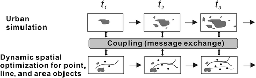
This proposed system adopts a loose coupling strategy that is based on message exchange. This coupling is implemented in three ways: (1) run the simulation module first, and then run the optimization module using the simulation outcomes as the inputs; (2) run the optimization module first, and then run the simulation module using the optimization outcomes as the inputs; and (3) reciprocally run the simulation and the optimization ().
Figure 1. A loose coupling strategy between simulation and optimization.
The coupling is expected to produce better performances on completing simulation and optimization tasks. For example, an optimal pattern (e.g., facility sitting) can be created using the ACO model according to the inputs of urban simulation. Various optimal patterns can be generated based on either exiting (static) land use patterns or predicted (dynamic) land use patterns. A way to identify the best optimal pattern among them is based on the accumulative utility. If an optimal pattern (e.g., the optimal facility sitting based on the simulated land use in 2015) is implemented now, its effects should not be just evaluated by the current land use patterns. The benefits of an optimal pattern should be calculated under a dynamic environment within a planning period. The accumulative utility value () is thus defined to address these accumulative effects using the following equation:
It is possible to generate various optimal patterns according to the inputs of different simulated land use patterns. However, the best optimal pattern can be identified according to the maximum accumulative utility value as described in EquationEquation (25)(25). Traditionally, an optimal pattern is generated based on existing land use patterns, assuming that the land use patterns are static. Actually, a dynamic optimization based on this coupling mechanism should be more plausible for finding the best optimal pattern under a changing landscape.
3. Implementation of GeoSOS
3.1. The interface of GeoSOS and its components
GeoSOS was designed in an object-oriented programming (OOP) paradigm. This proposed system was developed using the Microsoft .NET Framework version 2.0 and C# (GeoSOS is available at http://www.geosimulation.cn/). is the logic structure of GeoSOS and is the UML class diagram of its components library. This system provides the functionality for implementing CA, ABMs, and SIMs (). GeoSOS can read and output the files in the ASCII Grid format which can be accepted by some common GIS packages, such as ArcGIS.
Figure 2. Logic structure of a GeoSOS.
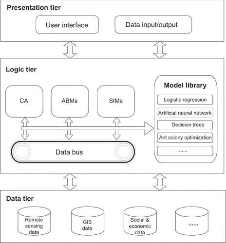
Figure 3. UML class diagram of the GeoSOS components library.
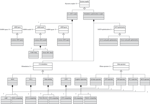
Figure 4. GeoSOS with its three components, CA, ABMs, and SIMs for simulation and optimization.
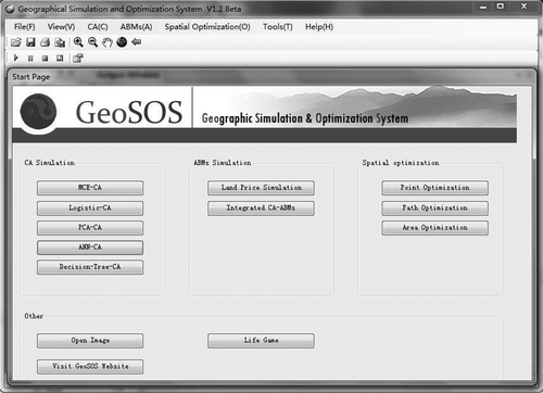
The first component of GeoSOS consists of a number of common CA models, such as MCE-CA (Wu and Webster Citation1998), logistic-CA (Wu Citation2002), PCA-CA (Li and Yeh Citation2002a), ANN-CA (Li and Yeh Citation2002b), and decision-tree CA (Li and Yeh Citation2004). The second component is related to ABMs (some functions of this component are still under construction). The third component includes three optimization modules that are developed by modifying conventional ant algorithms as described in Section 2.2.3. These three components should be able to solve a variety of facility (point) siting, path finding, and area optimization problems. The following sections will introduce four experiments which examine the effects of integrating various dynamic process models under GeoSOS.
3.2. Integration of CA and ABMs for simulating residential development
The first experiment was carried out to examine whether the integration of CA and ABMs could produce more plausible simulation results. This integrated model was used to simulate the residential development in Haizhu district of Guangzhou City in 1995–2004. The land use types in this study area include greenbelt, farmland, water, road, old-developed residential land, and newly developed residential land. The simulation was based on the joint probability of CA and ABMs. lists the weights for different groups of residents, which were used for EquationEquation (13)(13) (Saaty Citation1990). The number of agents for each group is proportional to the percentages of its population. This integrated model yields the simulated patterns for the residential development in the study area in 2004 (). The simulated residential development () can be compared with the actual residential development () to reveal the agreement and disagreement visually. Very plausible results have been confirmed by comparing these two patterns.
Table 1. Weights for different groups of resident agents obtained using Saaty's AHP method
Figure 5. Integration of CA and ABMs for simulating residential development in Guangzhou. (a) Simulated residential development and (b) actual residential development.
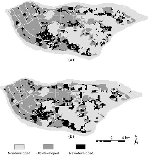
The performances of this integrated model were compared with those of pure CA models, such as logistic-CA (Wu Citation2002). The validation shows that the integrated model has the overall accuracy of 0.79, whereas the logistic-CA has the overall accuracy of 0.51. The logistic-CA model has a low accuracy because this model has not explicitly incorporated the influences of human and social factors in simulating residential development. The integrated CA-ABMs approach can produce better outcomes for modeling residential development in this study area. This approach could be useful when human-based interactions play an important role in shaping urban processes. However, such an approach is quite data-demanding because detailed social and economic data should be available.
3.4. Coupling urban simulation with spatial optimization
In the past, urban simulation and spatial optimization models were isolated in applications. GeoSOS provides an opportunity of combining these two kinds of models within an integrated architecture. It is expected that spatial optimization, such as optimal point siting, path finding, and formation of protected areas, should be related to land use dynamics for producing better modeling effects. The objective is to formulate the optimal patterns which can yield the maximum accumulative utility values under a changing landscape.
3.4.1. Coupling land use dynamics with facility sitting
The second experiment was carried out to couple facility (point) optimization with urban simulation for solving dynamic optimization problems. Point optimization for siting major facilities is a common task required in planning practice. An example is to find the optimal location for siting solid waste transfer stations in large cities. Citizens have increasingly voiced concerns about the locations of solid waste transfer stations. One major concern is that the stations are disproportionately concentrated in or near their communities. Site selection models could be used to provide an acceptable (fair) solution to this problem. The objective is to identify the best N locations (targets) that can produce the largest value of a utility function in terms of maximum population coverage and minimum transport cost. The exhaustive blind (brute-force) method for solving point optimization problems with high-dimensional spatial data is infeasible because of a huge combinatorial solution space.
The study area was situated in Shenzhen, a fastest growing city in China. According to the government data, the daily production of solid waste was 8890 kg3 in 2003, which is 222 times more than that in 1979. The rapid increase of solid waste needs to build many new waste transfer stations in the city. In this study, the facility sitting ACO module of GeoSOS was used to identify the sites for siting 100 new waste transfer stations which will serve the growing population of Shenzhen. The optimal facility siting problem can be solved based on existing distribution of population. However, such optimization is static because it does not consider possible land use/population dynamics. Actually, the urban area of this city is growing rapidly recently because of fast economic development. Facility planning should include the factor of urban expansion by generating the maximum accumulated utility in a planning period. It is apparent that the built facilities will be outdated very soon without considering urban dynamics. Therefore, the solution to such problem requires the coupling of facility optimization models with urban simulation models.
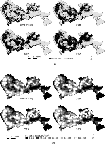
The annual growth rate of population was 1.1% according to the historical trend. Urban growth in the planning period of 2002–2030 was simulated using the logistic-CA of GeoSOS (a). The total population in this period was forecasted according to the annual growth. Then the population distribution in 2002–2030 was obtained by proportionally disaggregating the total population into each cell of the simulated built-up areas. is the predicted distribution of population densities in this planning period.
Figure 6. (a) Simulated built-up areas and (b) simulated population densities for spatial optimization in the planning period.
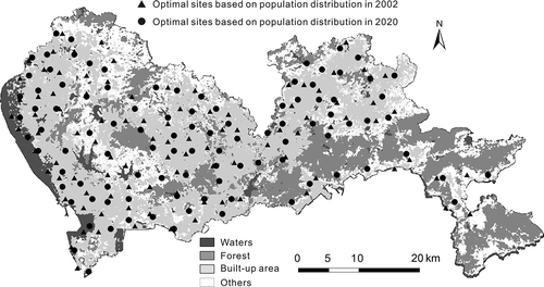
The optimal siting of 100 new waste transfer stations under a changing landscape was explored using the facility siting ACO of GeoSOS. The optimal patterns will vary by inputting different predictions of land use/population distributions in different years. However, the best optimal pattern can be identified based on the utility assessment as described in EquationEquation (25)(25). The comparison indicates that the dynamic optimization can produce better performances than the static optimization. The optimal siting based on existing land use/population in 2002 has the lowest accumulative utility, whereas the optimal siting based on the simulated land use/population in 2020 has the maximum accumulative utility (). shows the difference between the static optimization and dynamic optimization for siting 100 waste transfer stations in Shenzhen. Compared with the noncoupling model, the coupling model can have the improvement of the accumulative utility value by 2.6% for this region.
Figure 7. Accumulative utility of different optimal facility sitting schemes based on various predictions of population distribution.
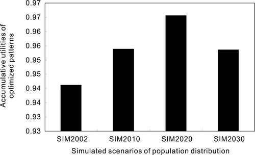
Figure 8. Difference between the static optimization and dynamic optimization for sitting 100 waste transfer stations in Shenzhen using facility sitting ACO.
3.4.2. Coupling land use dynamics with transport development
There exists a reciprocal relationship between land use dynamics and transport development (Oduwaye Citation2007). Urban development is significantly affected by the road-driven mechanism, especially in fast-growing regions (Clarke et al. Citation1997, White et al. Citation1997). Land use patterns also have a potentially large impact on transport development (van Wee Citation2002). This relationship is sometimes referred to as the transportation–land use ‘link’ or ‘cycle,’ emphasizing a feedback mechanism (Kelly Citation1994). Modeling this relationship is usually carried out using the top-down approaches. These approaches specify the interaction between transport networks and location as a set of aggregate relationships. Instead, microsimulation models have the advantages for modeling the interrelated choices individuals made in terms of location and travel behavior.
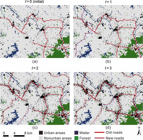
The third experiment was an attempt of exploring such reciprocal relationship. Urban development was simulated using the logistic-CA, and the related road networks were generated using the path optimization ACO. CA models alone have limitations in simulating the interrelated transport–land use system. The coupling between urban simulation and spatial optimization provides a convenient way to analyze such feedback relationship. During the integrated modeling, urban growth is dependent on road development because of the road-driven mechanism. New urban areas will create the transport demands that need to build more roads. These new roads are expected to provide the service to the uncovered areas as much as possible. The optimization model can thus be used to generate these new roads based on the simulated urban dynamics.
a shows the initial land uses and road networks in a part of Dongguan. In the second stage (t = 1), new urban areas were created according to the CA model. The path optimization model was then used to simulate the new roads that can optimally provide the service to the new uncovered urban areas (). In the third stage (t = 2), new urban areas continue to grow based on the development trends. The path optimization model was used again to create new roads for satisfying the new demands from the urban growth (). This process continues so that the transportation–land use feedback can be reciprocally modeled according to this coupling mechanism (). The comparison indicates that this coupling model can have the improvement of simulation accuracy by 12.9%, compared with the noncoupling model. Therefore, coupling these two bottom-up models will provide a more powerful tool for analyzing and understanding the mutual influences between land use dynamics and transport development.
Figure 9. Simulating the reciprocal relationship between land use dynamics and transport development by coupling CA and path optimization ACO.
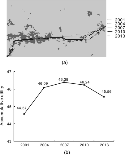
The experiment will also test whether the better path optimization results can be created based on the predicted land use patterns. It is expected that facility planning should not be just based on existing (static) land use patterns. The simulation of land use dynamics can provide more reasonable inputs to the optimization models for transport planning. For example, a shows the optimal paths identified using ACO for providing the maximum population coverage and minimum travel costs under various scenarios of land use patterns. The predicted land use patterns in 2001, 2004, 2007, 2010, and 2013 are used as the inputs to the optimization model, respectively. is the total accumulative utility value of each optimal path. It is found that the path based on existing land use in 2001 cannot produce the maximum accumulative utility for the whole period. Actually, the optimal path based on the predicted land use in 2007 can produce the best accumulative utility value for this whole planning period. The total utility will be improved by 4.1% using this coupling approach. Therefore, optimal facility planning should be coupled with land use dynamics for producing the best utility. This is especially important for fast-growing regions where there are a lot of land use changes. This proposed system can provide some vision capability for solving the simulation and optimization problems.
Figure 10. Identification of the optimal path according to accumulative utility of predicted land use changes. (a) Optimal paths based on predicted land use and (b) accumulative utility values of these optimal paths.
3.4.3. Coupling land use dynamics with the formation of natural protected areas
The fourth experiment is related to the area optimization that is required for a variety of applications, such as selecting biological reserves, hazardous waste sites, and landfill. The protection of important natural areas is crucial for reducing the loss of biodiversity associated with land conversion and development (Snyder et al. Citation2004). The area optimization ACO of GeoSOS can be used to generate such protected areas.
The study area is situated in Panyu in the Pearl River Delta, China. It has an area of 786.2 km2. According to the classified satellite TM images, Panyu has an urban area of 173.3 km2 in 2003 and 243.6 km2 in 2008. The annual rate of urban expansion is as high as 7%. Empirical studies have shown that urban land expands by 3% when the economy, measured by gross domestic product, grows by 10% in China (Deng et al. Citation2008). In terms of its economical growth, the rate of land consumption in Panyu is unusually higher than the average rate in China. This could cause severe land use conflicts in this fast-growing region because its land resources become very scarce.
The logistic-CA of GeoSOS was applied to the prediction of future urban development in the study area. This CA model was calibrated according to classified 2000 and 2003 TM images. The classified 2008 image was used to assess the simulation accuracy. The overall accuracy is 82.2% based on the cell-by-cell comparison (Li and Yeh Citation2004). Then this CA model was used to predict the urban growth of the study area in 2008–2030 (a).
Figure 11. Coupling land use dynamics with the formation of natural protected areas.
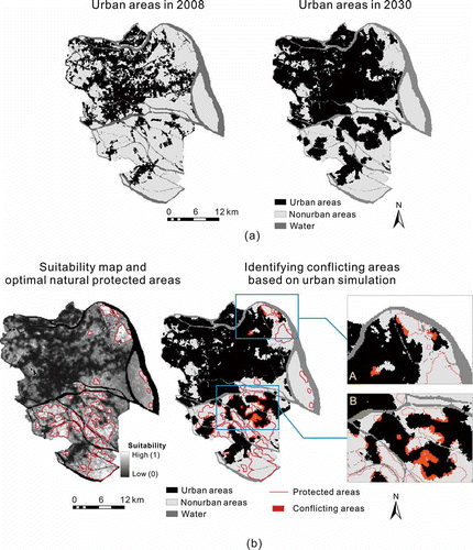
It is assumed that this region requires at least 100 km2, which is 12.7% of its total area, for protecting its vital ecological system. The optimization for natural protection was based on the suitability and contiguity constraints. Each site was evaluated according to its significance for nature conservation. The suitability layer for natural protection was prepared according to the common procedures of suitability analysis (Eastman et al. Citation1995). The factors for estimating the suitability include vegetation index, proximity variables (distance to towns, distance to highways, and distance to roads), slope, and density of urbanized areas. The slope was derived from 30 m DEM, and the density of urbanized cells was calculated using a moving window of 7 × 7. Finally the resolution of all these data was downgraded to 100 m (76,516 cells in total). The value ranges of these spatial variables were normalized into 0–1 for calculating the land use suitability map.
The area optimization ACO of GeoSOS was then used to formulate the natural protected areas, which were delineated by the red lines in . However, the optimization was based on existing (static) land use patterns. Such optimization could produce severe land use conflicts because it ignores land use dynamics. It is expected that the city will continue to grow based on the existing development trend. There were 416.9 km2 of urban areas in 2030 according to the CA forecasting. The conflicting areas were identified by overlaying the protected areas with the predicted urban areas in 2030. There was a conflicting area of 10.1 km2 shown as the red areas in . This integrated approach can thus help to assist in the prevention of such land use conflicts by adopting specific land use policy.
4. Conclusions
This article discusses the concepts and methodologies of a GeoSOS. GeoSOS is developed to provide the functions of CA, ABMs, and SIMs in a user-friendly way. This system consists of powerful toolboxes for simulating and optimizing complex natural systems.
Simulation and optimization are treated as independent processes in many spatial models. This approach has apparent limitations when the study area is experiencing fast changes of its environments. This study has demonstrated that coupling the simulation with the optimization can produce much better modeling effects. For example, the coupling model can have the improvement of the accumulative utility value by 2.6% for the optimal siting of waste transfer stations in Shenzhen compared with the noncoupling model.
It is well accepted that transport and land-use are strongly interrelated (Wegener Citation2004). The experiment has shown that the interrelated transport–land use system can be well simulated by coupling CA with the ACO path optimization model. More realistic urban growth patterns are generated by this integrated approach. The comparison indicates that the simulation accuracy can be improved by 12.9%. It is also found that conventional path optimization cannot produce the best results under a changing landscape. However, the scenario with the highest accumulative utility value can be identified by coupling the path optimization model with urban CA. The experiment indicates that this coupling approach has an improvement of the total utility by 4.1% by using the dynamic optimization approach.
The experiment also confirms that the coupling of area optimization model with urban CA can help identify conflicting areas when preparing natural protected areas. In many fast-growing regions, optimal zoning of protected areas based on static land use has severe limitations because of ignoring potential land use changes. This integrated approach may yield useful information for preparing specific land use policy that can prevent or alleviate potential land use conflicts in fast-growing regions.
Acknowledgment
This study was supported by the Key National Natural Science Foundation of China (Grant No. 40830532), the National Outstanding Youth Foundation of China (Grant No. 40525002), and the National Natural Science Foundation of China (Grant No. 40901187).
Related Research Data
References
- An , L. 2005 . Exploring complexity in a human-environment system: An agent-based spatial model for multidisciplinary and multiscale integration . Annals of the Association of American Geographers , 95 : 54 – 79 .
- Batty , M. and Xie , Y. 1994 . From cells to cities . Environment and Planning B: Planning and Design , 21 : 531 – 548 .
- Benenson , I. 1998 . Multi-agent simulations of residential dynamics in the city . Computers, Environment and Urban Systems , 22 : 25 – 42 .
- Benenson , I. , Omer , I. and Hatna , E. 2002 . Entity-based modeling of urban residential dynamics: the case of Yaffo, Tel Aviv . Environment and Planning B , 29 : 491 – 512 .
- Bousquet , F. 1993 . Simulating the interaction between a society and a renewable resource . Journal of Biological Systems , 1 : 199 – 214 .
- Chen , J. 2002 . Assessment of urban development plan of Beijing by using CA-based urban growth model . Photogrammetric Engineering & Remote Sensing , 68 ( 10 ) : 1063 – 1071 .
- Clarke , K.C. and Gaydos , L.J. 1998 . Loose-coupling a cellular automaton model and GIS: long-term urban growth prediction for San Francisco and Washington/Baltimore . International Journal of Geographical Information Science , 12 : 699 – 714 .
- Clarke , K.C. , Hoppen , S. and Gaydos , L. 1997 . A self-modifying cellular automaton model of historical urbanization in the San Francisco Bay area . Environment and Planning B: Planning and Design , 24 : 247 – 261 .
- Dean , J. 2000 . “ Understanding anasazi culture change through agent-based modeling ” . In Dynamics in human and primate societies , Edited by: Kohler , T. and Gumerman , G. 179 – 206 . Oxford, UK : Oxford University Press .
- Deng , X.Z. 2008 . Growth, population and industrialization, and urban land expansion of China . Journal of Urban Economics , 63 : 96 – 115 .
- Dorigo , M. and Gambardella , L.M. 1997 . Ant colony system: a cooperative learning approach to the traveling salesman problem . IEEE Transaction on Evolutionary Computation , 1 : 53 – 56 .
- Dorigo , M. , Maniezzo , V. and Colorni , A. 1991 . Positive feedback as a search strategy. Technical Report , 91 – 106 . Milan : Politecnico di Milano .
- Dorigo , M. , Maniezzo , V. and Colorni , A. 1996 . Ant system: Optimization by a colony of cooperating agents . IEEE Transactions on Systems, Man, and Cybernetics – Part B , 26 : 1 – 13 .
- Eastman , J.R. 1995 . Raster procedures for multi-criteria/multi-objective decisions . Photogrammetric Engineering and Remote Sensing , 61 : 539 – 547 .
- Gahegan , M. 1999 . Guest editorial: what is geocomputation? . Transactions in GIS , 3 : 203 – 206 .
- Hagen-Zanker , A. 2006 . Map comparison methods that simultaneously address overlap and structure . Journal of Geographical Systems , 8 : 165 – 185 .
- Huang , B. , Liu , N. and Chandramouli , M. 2006 . A GIS supported Ant algorithm for the linear feature covering problem with distance constraints . Decision Support Systems , 42 : 1063 – 1075 .
- Janssen , M.A. and Ostrom , E. 2006 . Empirically based, agent-based models . Ecology and Society , 11 : 37
- Kelly , E.D. 1994 . The transportation land-use link . Journal of Planning Literature , 9 ( 2 ) : 128 – 145 .
- Li , X. and Yeh , A.G.O. 2000 . Modelling sustainable urban development by the integration of constrained cellular automata and GIS . International Journal of Geographical Information Science , 14 : 131 – 152 .
- Li , X. , He , J.Q. and Liu , X.P. 2009a . Intelligent GIS for solving high-dimensional site selection problems using ant colony optimization techniques . International Journal of Geographical Information Science , 23 : 399 – 416 .
- Li , X. , He , J.Q. and Liu , X.P. 2009b . Ant intelligence for solving optimal path-covering problems with multi-objectives . International Journal of Geographical Information Science , 23 : 839 – 857 .
- Li , X. and Liu , X.P. 2007 . Defining agents' behaviors to simulate complex residential development using multicriteria evaluation . Journal of Environmental Management , 85 : 1063 – 1075 .
- Li , X. , Yang , Q. S. and Liu , X. P. 2008 . Discovering and evaluating urban signatures for simulating compact development using cellular automata . Landscape and Urban Planning , 86 ( 2 ) : 177 – 186 .
- Li , X. and Yeh , A.G.O. 2002a . Urban simulation using principal components analysis and cellular automata for land-use planning . Photogrammetric Engineering & Remote Sensing , 68 ( 4 ) : 341 – 351 .
- Li , X. and Yeh , A.G.O. 2002b . Neural-network-based cellular automata for simulating multiple land use changes using GIS . International Journal of Geographical Information Science , 16 : 323 – 343 .
- Li , X. and Yeh , A.G.O. 2004 . Data mining of cellular automata's transition rules . International Journal of Geographical Information Science , 18 : 723 – 744 .
- Liu , N. , Huang , B. and Pan , X. 2005 . Using the Ant Algorithm to derive Pareto Fronts for multi objective siting of emergency service facilities . Transportation Research Record: Journal of the Transportation Research Board, 1935 , : 120 – 129 .
- Liu , T. , Li , X. and Liu , X. P. 2010 . Integration of small world networks with multi-agent systems for simulating epidemic spatiotemporal transmission . Chinese Science Bulletin , 55 ( 13 ) : 1285 – 1293 .
- Lo , C.P. and Yeung , A.K.W. 2002 . Concepts and techniques of geographic information systems , Upper Saddle River, NJ : Prentice Hall .
- McFadden , D. 1978 . “ Modeling the Choice of Residential Location ” . In Spatial interaction theory and planning models , Edited by: Karlqvist , A. L. 75 – 96 . Amsterdam : North Holland Publishing Co .
- Oduwaye , L. 2007 . Effects of institutional land uses on road traffic in metropolitan Lagos . The Social Sciences , 2 ( 3 ) : 255 – 263 .
- Parpinelli , R.S. , Lopes , H.S. and Freitas , A.A. 2002 . Data mining with an ant colony optimization algorithm . IEEE Transaction on Evolutionary Computation , 6 ( 4 ) : 321 – 332 .
- Pontius , R.G. and Schneider , L.C. 2001 . Land-cover change model validation by an ROC method for the Ipswich watershed, Massachusetts, USA . Agriculture, Ecosystems and Environment , 85 : 239 – 248 .
- Purnomo , H. 2005 . Developing multi-stakeholder forest management scenarios: a multi-agent system simulation approach applied in Indonesia . Forest Policy and Economics , 7 : 475 – 491 .
- Robinson , D.T. 2007 . Comparison of empirical methods for building agent-based models in land use science . Journal of Land Use Science , 2 ( 1 ) : 31 – 55 .
- Saaty , T.L. 1990 . The analytic hierarchy process: planning, priority setting, resource allocation , Pittsburgh, PA : University of Pittsburgh .
- Sharma , A. , Vyas , V. and Deodhare , D. 2006 . “ An Algorithm for Site Selection in GIS based on Swarm Intelligence ” . In 2006 IEEE Congress on Evolutionary Computation Sheraton Vancouver Wall Centre Hotel , 1020 – 1027 . Vancouver, BC : IEEE .
- Snyder , S.A. , Haight , R.G. and ReVelle , C.S. 2004 . Scenario optimization model for dynamic reserve site selection . Environmental Modeling & Assessment , 9 : 179 – 187 .
- Star , J. and Estes , J. 1990 . Geographical information systems: An Introduction , Englewoods Cliffs, NJ : Prentice Hall .
- Sui , D.Z. and Zeng , H. 2001 . Modeling the dynamics of landscape structure in Asia's emerging desakota regions: a case study in Shenzhen . Landscape and Urban Planning , 53 : 37 – 52 .
- Torrens , P.M. and Benenson , I. 2005 . Geographic automata systems . International Journal of Geographical Information Science , 19 : 385 – 412 .
- van Wee , B. 2002 . Land use and transport: research and policy challenges . Journal of Transport Geography , 10 : 259 – 271 .
- Ward , D.P. , Murray , A.T. and Phinn , S.R. 2000 . A stochastically constrained cellular model of urban growth . Computers, Environment and Urban Systems , 24 : 539 – 558 .
- Wegener , M. 2004 . “ Overview of land use transport models ” . In Handbook of transport geography and spatial systems , Edited by: Hensher , D.A. Amsterdam : Oxford, Elsevier .
- White , R. , Engelen , G. and Uljee , I. 1997 . The use of constrained cellular automata for high-resolution modeling of urban-land dynamics . Environment and Planning B: Planning and Design , 24 : 323 – 343 .
- Wie , B.C. and Chai , W.Y. 2004 . An intelligent GIS-based spatial zoning system with multiobjective hybrid metaheuristic method , 769 – 778 . Ottawa, ON : Springer Verlag .
- Wu , F. and Webster , C.J. 1998 . Simulation of land development through the integration of cellular automata and multicriteria evaluation . Environment and Planning B , 25 : 103 – 126 .
- Wu , F.L. 2002 . Calibration of stochastic cellular automata: the application to rural–urban land conversions . International Journal of Geographical Information Science , 16 : 795 – 818 .
- Xie , Y.C. , Batty , M. and Zhao , K. 2007 . Simulating emergent urban form using agent-based modeling: Desakota in the Suzhou-Wuxian region in china . Annals of the Association of American Geographers , 97 : 477 – 495 .