
Abstract
A critical need exists to broaden and deepen sustainability information foundations that can foster growth of actionable knowledge about human–environment relations to address grand challenges in sustainable system domains such as sustainable development, social–ecological systems, and hazards influencing global environmental change. Broad-based information is needed to integrate across domains to address sustainability problems cast as complex systems problems that vary widely across space and time. Deep-based information is needed to address nuanced and contextual relationships that exist within and across domains. Both broad and deep information together are needed to better address spatial–temporal dynamics in complex sustainable systems. According to many publications, the concept of sustainable systems is considered to be at the core of self-organizing systems; and in turn, the concept of self-organizing systems is at the core of social–ecological systems, coupled natural–human systems, and human–environment systems. The sustainable systems concept is elucidated in terms of ontological and epistemological foundations from geographic information representation theory. A framework for Measurement-informed Ontology and Epistemology for Sustainability Information Representation, drawing from research about ontology and epistemology in geographic information science, provides the foundation for elucidating concepts and relations about sustainability information representation in general and sustainable systems in particular. The framework is developed to form a core of sustainability information representation theory, and consequently provides a basis for articulating first principles about the character of space–time data models that can be used to create computational models within geographic information systems (GIS). An example applies the framework to common pool resources as sustainable systems. Developing the framework and exploring an example fosters intellectual bridge building between sustainability science and sustainability management in the form of a sustainability information science. That intellectual bridge building of sustainability information science supports societal progress moving knowledge into decision action toward sustainable development, encouraging new insight for designs of space–time data models, and extending GIS as an information technology foundation for sustainability management. Conclusions and directions for next steps in research about sustainability information representation theory in general and sustainable systems in particular are offered.
1. Introduction
Research about ways of framing human–environment relations in geography has a long and rich history and such frames often focus on particular kinds of interaction. Sustainability as a fifth-generation frame for human–environment interaction in geographic research is attracting considerable attention (Harden Citation2012); but the sustainability topic expands well beyond the discipline of geography. In a commentary about the character of sustainability science that draws upon multiple literatures, Kates (Citation2011a) defines the concept of sustainability, following the Proceedings of the National Academy of Sciences (PNAS Citation2010, p. 19449), as ‘… an emerging field of research dealing with the interactions between natural and social systems, and with how those interactions affect the challenge of sustainability: meeting the needs of present and future generations while substantially reducing poverty and conserving the planet’s life-support systems.’ The definition is clearly broad-based, presenting a spatial–temporal information representation challenge and opportunity for members in the geographic information science (GIScience) community whose interest is in connecting sustainability science (Kates Citation2010, Bettencourt and Kaur Citation2011, Kates Citation2011a) and sustainability management (Campagna Citation2005, Jankowski et al. Citation2006, Nyerges and Jankowski Citation2010, Hansen and Brown Citation2011) and, thus, moving knowledge into decision action (Davis et al. Citation2011, Kates Citation2011b), e.g., collective decision action about common pool resources within a sustainable social–ecological systems context (Ostrom Citation2005, Citation2007, Citation2009, Citation2010).
This paper articulates fundamental concepts as a foundation for a sustainability information representation theory. The research reported in this paper is in part a synthesis of conceptualizations about sustainability drawn from multiple fields of literature, including sustainable development (WECD Citation1987, Mebratu Citation1998, Kates et al. Citation2001, Turner and Robbins Citation2008), social–ecological systems (Norberg and Cumming Citation2008, Ostrom Citation2009, Cumming Citation2011), and hazards within environmental change (Wilson Citation1981, Citation2000, Cutter et al. Citation2008, Lam et al. Citation2012, Reams et al. Citation2012). From the synthesis, we contend that a spatial–temporal dynamic of sustainable systems is a fundamental concept that can be grounded in geographic information representation. The grounding is so important that the character of space–time sustainable systems is unifying and central to all other sustainability constructs. We use the phrase ‘sustainable systems’ as a synthesizing phrase among four systems perspectives, i.e., social–ecological systems, coupled natural-human-systems, human–environment systems, and hazards-receptor systems. Consequently, a sustainable system is a core concept to be treated within sustainability information representation theory and is defined as a collection of elements interacting through human–environment relations that together foster self-organization (Walker and Salt Citation2006, Cumming Citation2011). Understanding and reasoning about sustainable systems within space and time involves understanding how to measure the elements, the relationships, and the way in which those elements and relationships meet the needs of present and future generations to substantially reduce conditions such as poverty, while conserving the planet’s life-support systems which is the intended goal of all sustainability research (Walker and Salt Citation2006, Citation2012, Cumming Citation2011, Kates Citation2011b). Simultaneously, we need a framework to understand the dynamics of these relationships across space and through time and when, given local spatial or temporal context, the set of elements and relationships are inadequate to foster resilience (Walker and Salt Citation2006, Citation2012, Cumming Citation2011, Goulden et al. Citation2013). The foundation for sustainability information representation theory developed in this paper uses an intellectual core emerging out of geographic information representation theory (Schuurman Citation2006, Goodchild et al. Citation2007, Couclelis Citation2010) for bridging between theory in sustainability science (Kates Citation2010, Citation2011a, b, Bettencourt and Kaur Citation2011) and practice in sustainability management (Nyerges and Jankowski Citation2010, Hansen and Brown Citation2011). The bridge building, with a foundation in GIScience and extended into what might be called ‘sustainability information science’, is needed to better elucidate what we know about sustainability and transform this knowledge into (decision support) action (Kates Citation2011b). Whether GIScience or sustainability information science is the broader or deeper realm is of little importance at this time, as the answer is likely dependent on context. The important issue is that we need a better understanding of information representational approaches for characterizing spatial–temporal dynamics that improve our understanding and the computability of sustainable systems as a core contribution to bridge building between sustainability science and sustainability management. The contribution in this paper emerges through a GIScience perspective about information representation that deepens into a sustainability information representation perspective. Systematic articulation of a sustainability information representation in a stepwise manner as presented below results in a formalism that enables broader and deeper design and/or evaluation of spatial–temporal data models as a foundational step toward computability of complex sustainable systems.
An interest in a formal approach to sustainability information representation motivates a search for an intellectual foundation for transforming conceptual models into measurement-focused operational models of complex sustainable systems. Such a foundation will provide the intellectual infrastructure needed to develop software architectures that flexibly support the kinds of complex systems design needed to better understand and improve (redesigning) sustainable systems (Wilson Citation1981, Citation2000). Drawing on foundational concepts from geographic information representation theory in the form of information representation ontology (Schuurman Citation2006, Goodchild et al. Citation2007, Couclelis Citation2010), we characterize the dynamic behavior of biophysical and human components interacting as systems as a way of contributing to knowledge about geographic dynamics (Yuan and Stewart Citation2008), particularly human–environment interactions as the focus of sustainable systems (Harden Citation2012).
This paper is the first to link geographic information systems and sustainability science using information representation theory through ontology (Couclelis Citation2010). By linking those topics through ontology, we obtain several benefits. A well-defined ontological framework for sustainability information within a complex sustainable systems context will enable faster and clearer articulation of elements and relationships in models. The stepwise manner of relationship articulation within the framework will enable a clearer understanding of information gain about relationships in complex sustainable systems. Such understanding can enhance computational representation while increasing efficiency. By building upon existing space–time dynamic representation frameworks and casting relationships through a sustainable systems perspective, we seek to determine if existing ontological frameworks are sufficient to capture sustainable systems complexity and identify what if anything is missing. By identifying gaps in relationship representation, and filling these gaps, we demonstrate a contribution to both geographic representation and sustainability representation.
The remainder of the paper proceeds as follows. Section 2 presents the foundations for sustainability information representation drawn from literature about sustainability, GIS data models, and ontology to articulate the concept of sustainable systems, while focusing on issues of spatial–temporal dynamics. In Section 3, we develop an ontological–epistemological framework as the core of sustainability information representation theory. We use that framework in Section 4 to articulate expressions of space–time element-relationship-element (ERE) about common pool resources that focus on sustainable fisheries reported by Scholz et al. (Citation2005) and synthesized by Ostrom (Citation2009). We conclude in Section 5 drawing insights about the framework and offer directions for research to broaden and deepen concepts about understanding of and computing with sustainable systems.
2. Framing spatial-temporal dynamics of sustainability
Sustainability is a broad-based and deep concept as evidenced by the thousands of researchers and practitioners engaged with the topic (see Bettencourt and Kaur Citation2011 for a broad survey of research). We characterize the breadth of spatial–temporal dynamics needed for sustainability information through an overview of several conceptual frameworks posed in the scientific literature. We characterize the depth of spatial–temporal dynamics needed for sustainability information through an overview of geographic (information) representation theory.
2.1. Sustainability conceptual frameworks
The definition mentioned above from the PNAS website clearly not only embraces the definition published in Our Common Future by World Commission on Economic Development (WECD Citation1987) and the National Research Council report, Our Common Journey (NRC Citation1999), but also resonates with the latest ideas in a sustainability science workshop report (Levin and Clark Citation2010) that outlines several research questions for a sustainability science research agenda and mentions alternative frameworks that can be used to study sustainable systems. An important concern, then, is which of the frameworks is most useful for guiding research about sustainability and why? Threaded through the PNAS definition cited above, and embracing a dynamic human–environment interaction perspective by Harden (Citation2012), are multiple relationships among a variety of concepts, each collection of linked concepts forming a conceptual framework. For example, from the European Environment Agency (Citation1997) has come a conceptual framework containing links among Driving Forces, Pressures, State, Impact, and Response (DPSIR). Major trends (in driving forces) influence activities (that create pressures) that change the state of human and environmental systems and for which a societal response might or might not be needed to address any or all of the precursor concepts. Then there is the US National Research Council’s (Citation1999) sustainable development framework, posing important questions about ‘what is to be sustained?’ and ‘what is to be developed?’ Many (meta) variables are identified in the framework, each one being linked to/by another concept. Ostrom (Citation2009) explicates a sustainability analysis framework, which contains 8 components, identifies 53 variables, and assembles evidence about human–environment relationships within self-organizing social–ecological systems (Walters Citation1971, Prigogine and Nicolis Citation1977), as the focus of theory building for sustainability science through empirical testing of models. From an examination of those frameworks, we conclude that a qualitative character of system relationships is mathematically rigorous (Prager and Reiners Citation2009) and can be used as the core of the ontological framework developed below to focus on the spatial–temporal dynamics of sustainable (social–ecological) systems.
Embracing the existence of multiple conceptual frameworks about sustainability, and given that many frameworks are likely to be productive for research and/or practice, we are encouraged to dive deeper into the sustainability topic to focus on the nature of information from an information science perspective (Borko Citation1968). Ostrom (Citation2010) motivates such work by arranging sustainability conceptual frameworks, theories, and models in an ordered manner, starting from general scoping frameworks, through more nuanced specification within theories, to testable detail in models. Such an ordering encourages us to develop a sustainability information representation theory that draws upon ontological and epistemological perspectives to underpin all three. Guiding this investigation is a particular interest in diving deeper into the Ostrom (Citation2009) sustainability analysis framework, unpacking the relationship threads within that framework to explicate the breadth and depth of sustainable systems relations, and moving Ostrom’s sustainability (knowledge) framework into the realm of decision support action. However, much of Ostrom’s (Citation2009, Citation2010) work was aspatial in its development, although she recognized the importance of spatial and temporal relations and, thus, that spatial and temporal dimensions must be integrated into sustainability science research. At the same time, systematically treating the nuances of spatial–temporal relations within sustainability research can move geographic information representation theory forward, whether the theory is used to improve representations within GIS technology or spatial–temporal modeling technology more generally, as considerable work on spatial–temporal modeling of landscapes, population, climate change, and ecosystems is not GIS-based, but is spatially and temporally enabled (e.g., for a review, see Cumming Citation2011).
2.2. Geographic information foundations for sustainability information representation
Moving toward a robust foundation for sustainability information representation theory in general, and computing with data models that can represent sustainable systems in particular, we draw concepts from geographic information representation theory as the underpinning of spatial–temporal data models particularly in relation to the ontology of geographic information. Although few GIS developments have treated geographic dynamics of sustainability, there have been significant efforts at articulating needs and approaches for the underpinnings of geographic dynamics for spatial–temporal data model development on a variety of topics (Peuquet Citation2002, Worboys and Hornsby-Stewart Citation2004, Goodchild et al. Citation2007, Yuan and Stewart Citation2008). In early work, a major challenge with using GIS technology for sustainability problems involves the implementation of spatial–temporal process models to characterize interactions within complex systems (Kemp Citation1997a, b). In moving toward a general theory of geographic information representation, Goodchild et al. (Citation2007) recognize four constructs for representing phenomena (geo-atom, geo-fields, geo-objects, and field-objects). A geo-atom is the primitive construct among them for characterizing geographic dynamics, also called spatial–temporal dynamics. ‘A geo-atom is defined as an association between a point location in space–time [dimensions] and a property [dimension]. We write a geo-atom as a tuple <x, Z, z(x)> where x defines a point in space–time, Z identifies a property, and z(x) defines the particular value of the property at that point’ (Goodchild et al. Citation2007, p. 243). In regard to dynamics, they cross-referenced three dimensions (geometry, internal structure, and movement) and two conditions (cond1, cond2) unspecified to compose a spatial–temporal dynamics framework for eight geo-object cases. The dynamics described by Goodchild et al. (Citation2007) are important for many domains that can be characterized by geo-objects. Our purpose is not to recount those dynamics, as the exposition in their manuscript is excellent. Moving those ideas to implementation, software based on the geo-atom primitive was developed as a proof of concept to evaluate some of those dynamics (Pultar et al. Citation2010).
To nuance a geographic information representation into a sustainability information representation, it is necessary (but maybe not sufficient for some problems) that the Z (attribute in general not just elevation) realm should be considered in terms of a triple bottom line, i.e., as economic, social, and biophysical characteristics embedded in the definition of sustainability (Kates Citation2011a, b). Consequently, a sustainability element is considered a quintuple <spatial, temporal, economic, social, biophysical>. Although the <attribute> meta-dimension spans three necessary and sufficient meta-dimensions <economic, social, biophysical>, we are not limiting the specification to those three. Distinguishing the spatial–temporal perspective a bit further, Goodchild et al. (Citation2007) describe a fifth construct called a geo-dipole that represents interaction relations between two geo-atom constructs. They ‘… define a geo-dipole as a tuple connecting a property and value not to one location in space–time as in the case of the geo-atom but to two: <x1, x2, Z, z(x1, x2)>. Geo-dipoles capture the properties of pairs of points, or properties that are associated with two points rather than one’ (Goodchild et al. Citation2007, p. 251). They identified three examples (object-fields, metamaps, and association classes) that characterize the usefulness of a geo-dipole. Interestingly, their spatial–temporal dynamics framework was developed for geo-objects. However, it is clear from their paper that geo-dipoles are (at least) pairs of geo-atoms or geo-objects, not singular geo-objects. This leaves scholars unclear whether the framework called ‘Three dimensions of temporal variability in geo-objects’ is sufficient for characterizing the dynamics of sustainable systems if it does not apply to geo-dipoles. We presume it does NOT apply to geo-dipoles given the caption labeling of the framework. However, even if we assumed the framework did address geo-dipoles, none of the eight combinations of conditions, together with the examples provided, suggest application to geo-dipoles, that is, element-to-element interactions. As such, we take up the challenge here to add to their exposition for the geo-dipole concept through levels of information gain (Brinberg and McGrath Citation1985) for relationships as the basis of human–environment interactions within sustainable systems. We thus contribute to geographic (information) representation theory by focusing on geo-dipoles within a sustainable systems domain.
Herein, we recognize that a sustainability dipole (sus-dipole) (which both inherits and refines a geo-dipole) is a relationship between two (or more) sustainability element quintuples. For example in a fisheries situation, an element category i (fishers), described in terms of <sp(i), ti(i), ec(i), so(i), and bi(i)>, and another element category j (such as fish stocks), described in terms of <sp(j), ti(j), ec(j), so(j), and bi(j)> (where sp = spatial, ti = temporal, ec = economic, so = social, and bi = biophysical), form the construct of sus-dipole, ij, called a catch. This spatial–temporal element-relation-element (STERE) is fundamental to a sustainability information representation framework clarified below.
Over the past decade, many GIScience researchers conducted ontology-focused studies to formalize the information associated with geographic phenomena (e.g., Grenon and Smith Citation2004, Smith and Mark Citation2006). However, characterizing ontology of geographic phenomena has always been a challenge, since so many scholars, organizations, and public groups view the world in different ways. Other researchers (Schuurman Citation2006, Couclelis Citation2010), seeing a distinction between developing ontologies of phenomena as they exist in the world and those of information representations as they might exist in databases or software, recognized that an ontology and epistemology for geographic information representation might be a more productive way to proceed with articulating primitives of information, rather than focusing on the phenomena themselves. Some of the advantages of an ontology of information include: (1) focusing on purpose of application, rather than purpose of the world; (2) faster and clearer articulation of relationships and the definitions of relationships and elements; (3) identification of gaps in the sustainable systems being modelled; (4) information gain to scaffold understanding; and (5) computational efficiency. This ontological approach to information is in line with much of the research in information science that involved database systems (Gruber Citation2009); and even though Goodchild et al. (Citation2007) did not mention the distinction directly, the approach they took was motivated by ontology of representations as much as by ontology of phenomena.
Guarino (Citation1997, p. 298) argues that emphasis on ontology development should focus on agreement about specifications, and synthesized several definitions about ontology into: ‘An ontology is an explicit, partial account of the intended models of a logical language’, wherein information is at the core of language use. Guarino (Citation1997) goes on to say that models can develop best from shared conceptual frameworks, whereas the explicit ordering of conceptual framework, theory, and model offered by Ostrom (Citation2010) provides an additional insight about conceptualizing details. Within the context of computer and information sciences (and by reasonable extension GIScience), and particularly in relation to database systems, Gruber (Citation2009) describes ontology as a set of representational primitives with which to model a domain of knowledge or discourse, and Guarino (Citation1997) would add ‘shared primitives’ within a computer-based language to that perspective. The representational primitives are typically classes (or sets), attributes (or properties), and relationships (or relations among class members). The definitions of the representational primitives include information about their meanings and constraints on their logically consistent application to a problem. Continuing in the context of database systems, ontology can be viewed as a level of abstraction similar to conceptual data models, intended for modeling knowledge about entities, their attributes, and their relationships (Gruber Citation2009). Since ontologies are systemic and shared agreements, they form the basis of representation theory about spatial–temporal dynamics of sustainable systems as treated in the next section and can form the foundation for evaluating sustainability data models.
3. A framework for sustainability information representation theory
Several researchers mention information abstraction as important to ontology development, but none have discussed this issue in the context of spatial–temporal dynamics. Our main contribution to knowledge in this paper integrates four ontological frameworks into a single framework that forms a foundation for sustainability information representation theory. The four frameworks are: (1) ontology tiering (Guarino Citation1997); (2) geographic information representation ontology (Couclelis Citation2010) within the foundational level; (3) geographic (spatial–temporal) information representation theory constructs (Goodchild et al. Citation2007) across the levels; and (4) social–behavioral systems information gain (Brinberg and McGrath Citation1985) for expanding the depth of the concepts. The integrated outcome is called a Measurement-informed Ontology and Epistemology for Sustainability Information Representation (MOESIR) framework.
3.1. Ontologies of information representation
Exploring the foundations about how humans relate to information in computing, Guarino (Citation1997) recognizes multiple realms for ontology, for which we explicitly organize into four levels herein to synthesize and bring further significance to his ontological contribution (see ) as the core of our MOESIR framework contribution. Concepts at a foundation-level (also called upper- or top-level) ontology constitute a realm that is relevant to all domains, regardless of topic. Couclelis (Citation2010) used the foundational realm to focus her research on the foundations of geographic information representation that we will extend below. Stock et al. (Citation2012) develop a roughly ordered set of 10 ontologies, using an upper-level ontology as the foundation of the nine others that span all the way to application ontology of coastal science data. Although their contribution does not elucidate the ontologies in light of an abstraction framework, a reader can easily see a parallel and useful abstraction framework such as that in . The domain realm of ontologies builds on top of the foundation to include specific concepts to a topical situation; e.g., Stock et al. (Citation2012) describe a coastal science domain. Domain ontologies seek to further contextualize foundation ontologies by adding nuanced relationships specific to elements within topical domains, and by extension relationships across super-order domains. In another example, for a jurisdiction domain ontology, Lopez-Pellicer et al. (Citation2012) suggest that jurisdictional boundaries can be better understood over time if we make them specific to the place of development, given the place-based nature of laws and statutes that govern boundary development. Level 3 moves into the method realm and situates a topic in the context of a workflow activity. Work with topical domains establishes a problem context, and thus provides further insight into the character of information, e.g., workflow standards within an organization often sequence the way knowledge is created, and thus underpin organizational ways of knowing. Workflow method is akin to epistemology, that is, a process of articulating information for constructing shared knowledge, a way of coming to know (Sebastian et al. Citation2008).
Table 1. Four realms of ontology for situating information science (after Guarino Citation1997).
In refining the method realm, the application realm adds specific concepts for a work realm that further situates the use of information. In a geospatial context, constructs in this realm would situate information to a specific space and time. An application realm can add purpose or insights about what motivates the examination of a particular problem context (Jung and Sun Citation2010, Li et al. Citation2012, Stock et al. Citation2012). Each level thus adds refinement to the previous, offering both conceptual and contextual refinement and progressively making meaning more specific. At the same time, nuanced knowledge sometimes makes other knowledge less transferable because the qualities of situations are different (Nyerges Citation1991). The focus in this research is on level-1 foundational space–time and level-2 sustainability domain ontologies. Levels 3 and 4 are beyond the scope of the paper due to paper length constraints, but will be the topic of future research.
3.2. Extending ontological foundations of geographic information
Couclelis (Citation2010) articulates seven levels of an abstraction hierarchy that form the foundation of geospatial information representation (see ). We extend and refine the Couclelis (Citation2010) framework in terms of a logical division of four meta-levels of abstraction – content, structure, process, and context – originally composed for complex sustainable systems decision problems (Nyerges and Jankowski Citation2010), and integrated here to further clarify the seven levels 1.1–1.7 in MOESIR. Ontologically, content is the core of any system, whether the components are human, natural, or technological. Categorical content is the fundamental building block of databases. Structure is the association between and among those components (data categories), whether they are basic or new relationships. Thus, structure organizes content into meaningful associations. For sustainable systems, for example, we might consider structure to be connections among biophysical, social, and economic information categories as key structural elements. System process refers to dynamics in and across system structures, e.g., as in the five types of dynamics, labeled as activity, process, event, change, and movement, which are enumerated by Yuan and Stewart (Citation2008). Finally, context represents the ‘circumstances’, i.e., the situation for process that motivates and grounds meaning for structure and content. The context of a system can be interpreted as internal (endogenous) context or external (exogenous) context (Nyerges Citation1991). Components external to a system are what characterize ‘open systems’. Most (if not all) social–ecological systems are open systems. In other words, context matters, and thus we suggest, like Tang and Bennett (Citation2010), that context should be part of any model of a sustainable system, and therefore computable; and as Kwan (Citation2012) suggests context should be part of spatial–temporal problem characterization to foster nuanced understanding.
Table 2. Seven levels of a hierarchy for data/information constructs for object-fields (adapted from Couclelis Citation201Citation0) with expansion of the foundation level (level 1 of Guarino Citation1997) as a contribution to Measurement-informed Ontology and Epistemology for Sustainability Information Representation.
All seven levels (herein labeled 1.1–1.7) expand on the foundational realm offered by Guarino (Citation1997) and are developed within the domain context of sustainability, i.e., level 2 in . The most fundamental of the foundational levels is level 1.1, the existence of dimension. Level 1.1 is a recognition that properties exist for something in the world. At level 1.2, units of measurement are assigned to dimensionality (in ) in order to understand each dimension, even if the unit of measurement is a nominal quality. Bundling the dimensionality forms a geo-atom (Goodchild et al. Citation2007) at level 1.3. Extending the geo-atom to a sustainability (sus) element, the Z property is extended to, minimally, three meta-dimensional properties, social, economic, and biophysical taken as a bound set, meaning that trade-offs are likely to occur. Some might think this extension is trivial, but it is the underlying perspective for a sustainable world (that is, the triple bottom line of sustainability). Geo-atoms (and hence sus-elements) can be combined to create higher-order constructs, yet singular in their existence, e.g., geo-field (sus-field), geo-object (sus-object), object-field, and field-object to establish data at level 1.4. In regard to spatial–temporal dynamics, we offer further synthesis of the five dynamics identified by Yuan and Stewart (Citation2008) by expanding on the Couclelis (Citation2010) framework in a building block manner of abstraction whereby change, movement, and event appear to be operable at levels 1.3 (geo-atoms or sus-elements) and 1.4 (geo-fields and geo-objects or sus-fields and sus-objects). Change characterizes an element that retains a fixed location, which is observed at a before and after time, and for which the attribute data value, that is, z(x), is observed as different. An element moves when the element retains its identity attribute data value, which is observed at multiple times, and for which the location data value is different. An event is dynamic when an element(s) either change(s) and/or move(s), and thus an event can be considered a generalization over change and/or movement, the former two being the primitives of event. Consequently, at level 1.3, an object class is a bundle of dimensions for which three treatment modes (fixed, controlled, and measured) provide the character of the bundle (Sinton Citation1978). A geo-atom (or other higher construct) changes when location is fixed, time is controlled as before and after, and attribute is measured. A geo-atom (or other higher construct) moves when attribute is fixed, time is controlled in terms of before and after, and location is observed (moved to where). This primitive dynamic is inherited to higher order, but yet still singular instantiation, and forms a construct at level 1.4, as a bounded object class (class with dimensional constraints). The same dynamics would apply, but now as a collective as a class.
One of the biggest challenges for understanding social–ecological systems is how to characterize systems in terms of sus-elements and relations that form identity (Cumming Citation2011), and in turn how that identity influences a self-organizing, spatial–temporal dynamic (Ostrom Citation2009). Just how broad and deep does one go with granularity of phenomena for this conceptualization? Only the context of analysis, or what Couclelis (Citation2010) calls purpose, can provide an answer at level 1.7. Interestingly, when Couclelis (Citation2010) developed the ontology, the sequence of information abstraction to understand primitives starts at level 7 (herein 1.7), as it is the context of purpose that provides considerable meaning for interpretation of an abstraction. We recommend the same epistemological approach for MOESIR.
3.3. Measurement-informed Ontology and Epistemology for Sustainability Information Representation
Two or more sus-elements and the relation(s) among them form the fundamental basis for information structure at level 1.5. As mentioned earlier, these relationships are analogous to sus-dipoles, and thus can be used to represent human–environment interaction. Brinberg and McGrath (Citation1985) position relationships within social–behavioral systems in terms of … ‘this element is related to (has a relationship with) that element.’ Moving forward, we refer to this as an element-relationship-element (ERE) triple, wherein sus-element is a singular construct at levels 1.3 and 1.4 in . When considering pairs of sus-elements, more ontological–epistemological depth is needed at levels 1.5–1.7 to elucidate the spatial–temporal dynamic of a system relationship.
Since we are focusing on sustainability information representation theory to act as the bridge between sustainability science and sustainability management, it is important for us to enrich the above ontological–epistemological framework at level 1.5 (composites as relationships) to better characterize the spatial–temporal structure of a system relationship. It is at this level where additional formalized insight is important for gaining an understanding of relationships (i.e., the ERE triple) to improve measurement as a basis for computational activity and to further contribute to the management of sustainable systems. To better resolve the concept of relationships, we borrow from a framework published by Brinberg and McGrath (Citation1985) that specifies 10 levels of information gain about relationships associated with social–behavioral systems. Since social–behavioral systems can be equally complex to natural systems, but perhaps in different ways, it seems appropriate to apply their framework to analyze social–ecological systems, particularly to nuance the investigation of relationships between and among system elements. As such, a relationship between two elements is considered a basic system. An ERE representation of a basic system (relationship) is equivalent to a level 1.5 composite object (in ), but it is reinterpreted to focus on ‘relations’ between elements (geo-objects). Integrating the 10 levels of information gain from (i.e., 1.5.1–1.7.3) into deepens the ontology about spatial–temporal dynamics, resulting in the full exposition of MOESIR. depicts an outline sketch of the MOESIR framework.
Figure 1. Overview sketch of the MOESIR framework.
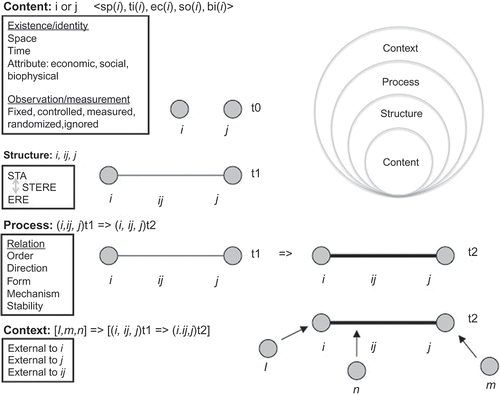
Table 3. Ten levels of information gain for a spatial–temporal element-relation-element (STERE) sustainability relationship at foundation levels 1.5–1.7 within .
Continuing to deepen the meaning and context of MOESIR, we articulate the importance of relations in systems as sus-dipoles via the multi-level information gain framework (Brinberg and McGrath Citation1985) using ‘elements and relations’ starting with level 1.5. Level 1.5.1 introduces the concept of relation existence (e.g., interaction existence as sus-dipole) as two elements that change and/or move in relation to one another based on an ‘identity’ of a sus-dipole through a primary characteristic (participating sus-elements). Nyerges (Citation1991) introduced the idea of primary and secondary characteristics that underlay the meaning of information classes. A primary characteristic provides identity to the information class, and in parallel by similar logic, a primary relation provides identity for a system (Cumming Citation2011). At level 1.5.2, once a relationship is conceptualized (or empirically identified), secondary characteristics can be loaded onto that relationship to provide further detail about the character as needed.
Although higher-order constructs that exist as multiples of geo-dipoles (object-fields, meta-maps, and association pairs) have been identified (Goodchild et al. Citation2007), elucidating MOESIR in light of a sus-dipole provides the foundational character of relations of interest, and thus we continue with the pairwise articulation of information gain at levels 1.6 (i.e., 1.6.1–1.6.5). A relation function (e.g., interaction dynamic of a sus-dipole) goes beyond the idea that a relationship simply ‘exists’ and has several properties, each of which is listed in a building block manner to add successively greater information to the relation. At level 1.6.1 is precedence order, for which one identifies which sus-element might be influencing another sus-element, i.e., is the relation a one-way or two-way influence? Next is level 1.6.2, directionality (in terms of flow of influence, not cardinal direction), wherein we establish whether the relation is positively or negatively or neither or both influencing the other, e.g., as in feedback directions. At level 1.6.3 is gradient form, asking whether the negative or positive influence is of a linear, nonlinear, monotonic, or non-monotonic nature, e.g., as in the magnitude of the direction established at level 1.6.2. At level 1.6.4 is an operational (mechanism) dynamic; is the relation made operational through a deterministic, probabilistic, or logic-based mechanism? Finally, at level 1.6.5 is spatial and temporal stability, asking whether stability of the dynamic is random, systematic, and/or periodic? Levels 1.6.1–1.6.5 can be considered properties of relations between pairs of sus-elements. As such, interaction, normally thought of as a primitive, is actually a meta-relation for which the levels 1.6.1–1.6.5 are the detailed properties of relations between any pair of elements within a sustainable system (e.g., fishers and fish stocks as a common pool resource). The property ordering (levels 1.6.1–1.6.5) adds information through successive levels, wherein higher levels of information (should) embed the lower levels of information. Successive levels of properties foster information gain, i.e., call it robustness, depth, and/or strength depending on perspective. If the information at the lower level is not contained within the higher level, then the higher-level property will be less certain, i.e., weakening the strength of a relationship.
Lastly in MOESIR, level 1.7 is for characterizing external relations (interactions) to a sus-dipole. External relations encourage conceptualization of exogenous influences on behavior of elements i, j, and relation ij. At level 1.7.1 is the external influence of l on i. At level 1.7.2 is the external influence of m on j. Finally, at level 1.7.3 is the external influence of n on ij. These external relations all come about by a third, fourth, and fifth sus-elements that impinge on the sus-dipole of interest. It is not too difficult to understand that we could get a computer to iterate on such relations to higher-level constructs. At this level of abstraction, we can consider other relations at multiple spatial–temporal scales as well (Holling Citation1973, Cumming Citation2011, Walker and Salt Citation2012), enabling conceptualization of external influences from l, m, and n. Elements (processes) at a more macro scale than the focal scale tend to guide and constrain elements at the focal scale, whereas elements (processes) at a more micro scale tend to influence the internal structure of elements and relations at the focal scale (Cumming Citation2011).
In the last consideration of dynamics, we treat activity and process (Yuan and Stewart Citation2008). These terms are so heavily laden with various contexts that single definitions are inadequate for investigating the underlying detail. Nonetheless, in the spirit of working through a synthesis, we define activity as one or more events (possibly in ordered or partially ordered sets) and/or interactions. Thus, an activity is an aggregation of lower-level dynamics and would require both construct and relation primitives to develop an understanding that is of any use. Finally, a process is considered to be a repetition of activity, implying a possible repetition of events and/or interactions. As such, it is also a higher-order relation that would rely on other primitives for elucidation. These latter two dynamics would more than likely get worked out with higher-order ontology as in level-3 methods and level-4 application ontologies appearing in ontology-tiering. As such, they are beyond the scope of this paper and to be explored in the details of future research.
The MOESIR refinement using the 10 levels of information gain from Brinberg and McGrath (Citation1985) serves to position relationships between observed objects ‘as measureable entities themselves’. In treating relationships in this manner, measurement (and measurability) becomes the defining criterion for representing the complexities of information associated with social–ecological systems character. For example, computing the resilience of a natural system following a critical transition (Holling Citation1973, Scheffer and Carpenter Citation2003, Cumming Citation2011, Walker and Salt Citation2012) will require a combination of direction of relationship (level 1.6.2), gradient for the relationship (level 1.6.3), mechanism as either a deterministic equation or stochastic probability (level 1.6.4), and stability of that relationship over time (level 1.6.5) in order to provide a basis for representation. The MOESIR framework speaks of the underlying character of Walker and Salt’s (Citation2012) focus on self-organizing sustainable systems (Prigogine and Nicolas Citation1977). Consequently, MOESIR constitutes a core framework for building a sustainability information representation theory, where computability of resilience will become a key property in the success of computability. Space does not permit full explication of several topics important to sustainability, including resilience, vulnerability, risk, and adaptive capacity that derive from the character of individual and collective relationships within complex sustainable systems. All these topics qualify as important directions for next steps of research that can extend the foundation of sustainable systems research.
Although other types of models exist that could be used to make sustainability relationships operational, this research focuses on data models describing the spatial–temporal dynamics of sustainable systems. In this context, a data model is defined as a combination of data structures, operations, and constraints (Codd Citation1981). Although the three components were first articulated in light of data management, those components apply to any software model (e.g., analysis and visualization as well) regardless of the computing language used for implementation. Conceptual (ontological) connections among models, theories, and conceptual frameworks in the context of sustainable systems have a rich literature involving more than 100 case studies (Poteete et al. Citation2010). That ontological perspective and collection of materials enables us to argue that a sustainability information representation theory could improve insight about the possibilities of assembling findings about sustainable systems, the need having been articulated about such computing support (Ostrom Citation2007, Citation2009). Computationally oriented sustainability information representation models of sustainable systems can be used to test hypotheses about relationships (in terms of information gain) within those systems. Consequently, our particular focus is on articulating the foundations of information representation theory-based data models for characterizing spatial–temporal dynamics of sustainable systems. Unfortunately, space available does not permit explication of the details of data models. Nonetheless, a substantive example presented below elucidates information gain about relationships.
4. Elucidating MOESIR using an example of a social–ecological system
The Ostrom (Citation2009) sustainability analysis framework mentioned in Section 1 presents a sustainable systems domain relevant to common pool resources (, level 2), remembering that the MOESIR framework is more generic (hence broader) than a single domain, but takes on additional meaning when developed in light of a sustainability domain. Detailing the 53 variables spread across the 8 components of the Ostrom (Citation2009) sustainability analysis framework using the MOESIR would take an enormous effort without a software tool. We offer here a brief examination of component-to-component linkages from Ostrom’s (Citation2009) framework that articulates three levels of granularity (systems, subsystem components (8 of them), and variables (53 of them)). In line with Cumming (Citation2011), recognizing the existence of a relationship at level 1.5.1 () which is a prerequisite for computability of a relationship, we look at human–environment interactions between resource users (fishers) and resource system units (fish species) balanced and regulated by governance systems in the context of common pool resources (Ostrom Citation2009). Consequently, at level 1.5 (), we recognize that resource harvesting (catch ij) as a relationship between resource users (i) and resource stocks (j) is an important concern in the world of fishers and fish stocks for many species that are in delicate balance, e.g., off the Oregon Coast (Scholz et al. Citation2005). The ERE (i, ij, and j) triple is the basic construct as given in level 1.5.1 in . Given the context of the self-organizing sustainable systems as characterized by Ostrom (Citation2009), a co-relation in space–time of an element is necessary when addressing influences on systems, e.g., the fish tickets as evidence of fish catch are generalized across a fishing ground to mask the actual takings in space, regardless of the granularity of the time (Scholz et al. Citation2005). As such, at level 1.5.1, the relationship (over/under resource use) is recognized as important, and at level 1.5.2, we want to know where and at what time the ij relationship is important, as mentioned earlier, off the Oregon Coast in a geo-field, and more specifically in a given fishing season for specific species. At this level, we establish an association between two sus-elements, or in a statistical sense the potential for correlation between an observed measurement associated with fishers (element i) and an observed measurement associated with fish stock resources (element j). The ij relation presented by Scholz et al. (Citation2005) was examined in terms of three relations, economic, social, and biophysical, thereby exploring the fundamental sustainability relationships, showing that biophysical limitations place economic constraints on the social well-being of the community. But just how to examine these inter-conditional relationships in detail remains to be accomplished.
At level 1.6, we further explore information gain about the fisher and fish stock relationship by characterizing detail as we move from level 1.6.1 through to level 1.6.5. At level 1.6.1 we establish a logical ordering of the functional relationship for resource (fish stick) use, i.e., the relationship between fishers and fishing stock adds information about logical order dependence using space, time, and/or attribute to characterize a functional measurement in the relationship. That is, the relationship is a specified collection of fishers working off the Oregon Coast. At this level of information we could begin to establish the character of the relationship between element i (fishers) and element j (fish stock), i.e., are fishers depleting fish stocks or not, due to increase in fishers and/or change in technology? At level 1.6.2, directionality introduces the idea of cardinality and magnitude associated with the relationship, i.e., the more fishers involved the more fish stocks are depleted, or might it be the inverse given regulations for time on the water? At level 1.6.3, we gain insight about an increasing or decreasing rate of influence, the more fishers the faster the increase in rate of depletion; however, this could be masked if fishers are also changing their technology to be more effective, i.e., dragging versus long-lines. Thus, at level 1.6.3, the functional form adds information about linear, nonlinear, or monotonic interaction to what we know at level 1.6.2, increasing at an increasing rate or decreasing rate of depletion. From a measurement perspective, we can ask if the increase and/or decrease strengthen across space and over time. Level 1.6.4 provides insight about the character (mechanism) of the form of increase and/or decrease. Is the influence one of a deterministic character (as in systems dynamics implemented as partial differential equations), of a probabilistic character (as in stochastic models given a type of population distribution), or is it a logic character (such as in an agent-based model with some kind of threshold or ‘trigger’ rule). For example, is the function one of a continuous resource use or is it a step function given the number of fishers having permission to fish, i.e., fishers come in clusters of a fleet. Resource users influencing resource stocks could be modeled with any one or all three of those types of processes. Level 1.6.4 influence mechanism provides the operating character of the space–time process; e.g., as associated with software genres introduced across the last four decades (Aguirre and Nyerges Citation2014). Level 1.6.5 introduces the stability of that process mechanism, that is, the frequency of the fishing activity (process mechanism) at work could be lumped by days representing an entire fishing season or spread across a year on a week-to-week basis. Is fishing an acute or chronic activity? Fishers might be on the water at different frequencies for exploring different species in different places, that is, spatial–temporal stability of use is a function of the (perceived) health of fish resources.
A variety of testable hypotheses regarding the observed and measured relationships thus emerges. If, for example, an understanding of the relationships between fishers and fish stocks was identified, but the stock appears to change in a manner inconsistent with the known relationships, then existence of potentially unidentified relationships could be unmasked. The information gain framework thus completes the foundational characterization of a STERE triple by recognizing that other elements and relationships could exist and influence the foundational elements and relationships of the focal i-fisher, j-stock, and/or ij-catch. At levels 1.7.1 and 1.7.2, an external influence might exist for either the fishers and/or the fish stocks. For example, as climate change is not the same everywhere, differing by region, it is possible that related events could increase or decrease within any given region, and thereby foster growth/decline in fish catch in different fishing grounds (m → j). The temperature of the oceans is rising in various currents around the world, and these currents are influencing weather patterns. Climate temperature influences (extreme) evaporation and winds, and the weather patterns influence the safety of fishing fleet (l → i). Finally, at level 1.7.3, an external influence n might exist for the relationship between the two elements such as regulators engaging to increase or suppress catch ij.
All 53 variables in the Ostrom (Citation2009) framework could be treated in this way by simply identifying two (i and j) element classes in the MOESIR framework at a time that could be related to one another. Ostrom (Citation2009) identified the self-organizing system variables, which are perhaps the most important variables as these represent the leverage points in sustainable systems, and these would be the first to be addressed. However, the main purpose of her article was to call for a systemic way to treat all of this information within an information (knowledge) management system. It is that call by Ostrom (Citation2007, Citation2009) and others more recently (Levin and Clark Citation2010) that further motivates the ontological approach herein, forming the basis of a systems coding scheme, as we move toward a sustainability information representation theory, and this example overviews the need for formalizing such a framework to further improve evidence-based research about complex relationships in sustainable systems.
In light of this example, we would remiss if we did not recognize that every framework, theory and model is value-laden to some extent by definition. Using the MOESIR framework, exploration of a relationship can proceed from different value-laden perspectives, and move forward in systematic and empirical ways. As many of the conceptual elements in Ostrom’s framework are organizational and people-centered, we hypothesize a human–environment interaction (as a relationship) exists and undertake empirical investigation and/or meta-analysis to discover the specific character of the relationship. The findings accumulated across case studies about fisheries as common pool resources viewed as sustainable systems is an excellent example (Ostrom Citation2007, Citation2009), but the spatial–temporal nuances have yet to be explicated.
5. Conclusions
Broadly speaking, the MOESIR framework contributed herein seeks to act as the foundation for an intellectual bridge between sustainability science and sustainability management; it is used in turn for elucidating a foundation for sustainability information representation theory as the core of a sustainability information science. The foundation developed in this paper provides the ontological–epistemological infrastructure of the bridge. Whereas tier 1 (foundational) and tier 2 (domain) ontologies contribute to ‘what is known’ about sustainability, the epistemological contribution to come in ontology tiers 3 (method) and 4 (application) will contribute to a ‘way of knowing’. Our contribution will hopefully provide others in the geographic (geospatial and sustainability) information science community and beyond in related scholarly communities with new insights about what is possible as we move to bridge, couple, and otherwise enable sustainability science and sustainability management, fostering progress with moving knowledge about sustainable complex systems into decision action.
The MOESIR framework fosters bridge building as it moves us closer to a formal understanding of the computability potential of relationships within sustainable systems and in particular those involving spatial–temporal dynamics. Systematic articulation of an information gain about relationships between two elements within a complex sustainable system results in a formalism that more easily enables the possibility of broad and deep design and/or evaluation of designs of spatial–temporal data models applicable to complex systems. At this time we call MOESIR a conceptual reference framework. Presenting MOESIR as four tiers (Guarino Citation1997), with in-depth articulation of tier 1, enables others to more easily unpack complex systems, no matter the domain of application. As such, the MOESIR framework with four tiers of ontology forms a practical guide for ontology engineering; but here we use it for complex sustainable systems in recognition of the tie to tier 2. We recognize the work is far from complete; this articulation clearly leads to further research questions about spatial–temporal data modeling, a topic gaining momentum through research about CyberGIS (Wang Citation2010, Wang et al. Citation2013). Tier 1 foundational ideas elucidated by Couclelis (Citation2010) are a major step forward. However, the level 5 composite object (levels being sub categories of tiers) ‘begged’ for a further formal investigation of information gain; such a nuanced exploration is performed in the ten levels of information gain provided in Brinberg and McGrath (Citation1985). A conceptual reference framework for spatial–temporal data models that incorporates content, structure, process, and context of problems is needed for broad and deep exploration of sustainable systems problems. Context computability (as shown by Tang and Bennett Citation2010 and Kwan Citation2012) is extremely important in complex problems. Articulating and elucidating context to frame computable constructs, processes, and constraints is one of the fundamental challenges for leading to a better understanding of complex problems.
Unpacking levels of information gain for relationships are not always straight forward, and can be significantly challenging at times, particularly for complex systems relationships. The large number of levels in MOESIR makes distinguishing between levels rather challenging due to the fine grain resolution of information, but at the same time rather informative because of the distinctions being identified. Nonetheless, awareness of stepwise information gain is a step forward in potentially improving understanding about information representation, noting that this paper integrates frameworks and levels from previously published (i.e., vetted) research. No doubt some relationships are more challenging to understand than others, and more or less levels could be useful in any particular problem; it will be up to a researcher to choose. Our domain of application being complex sustainable systems provides an excellent topic to help us sort this out. Nonetheless, there is no substitute for a good dose of critical thinking on any complex scholarly topic, and future research about tiers 3 and 4 will further clarify what is needed or not for designing and implementing computational (data) models of sustainable systems.
The MOESIR framework was developed with six dynamics (change, movement, process, activity, event, and interaction) in mind (Goodchild et al. Citation2007, Yuan and Stewart Citation2008), because a diversity of spatial–temporal dynamics are likely to be found in sustainable systems. A synthesis of the six types was performed, and integrated into MOESIR, but like other frameworks for spatial–temporal information, additional synthesis is needed. Even in its present state, however, MOESIR offers a means to evaluate the parsimony of different representations of complex sustainable systems. Even within the sustainability domain there is a need to deepen with applications to verify if this is a productive direction. Part of the verification can come from articulation of ontology at tiers 3 (method) and 4 (application) to further design requirements of space–time data models. Though this paper does not facilitate reporting on tiers 3 and 4, tier 3 methods are being explored through research about the geodesign framework involving six-phases of modelling (Steinitz Citation2012). Space–time systems modeling serves as the intersection between MOESIR and the second phase of the geodesign framework. Tier 4 application research focuses on integrated water management and resilience thinking in various locales around the United States. In addition to new data model designs, further evaluation of MOESIR can be performed using existing literature, e.g., the data models documented in Yuan and Stewart (Citation2008), and the one proposed by Pultar et al. (Citation2010) using a geo-atom primitive. Comprehensive elucidation of spatial–temporal sustainability constructs within a space–time data model context has yet to be performed. The material in this paper is a contribution in that direction.
Acknowledgments
We acknowledge the motivating concepts from Helen Couclelis without whose paper in this journal years of thinking on this topic might not have crystallized when they did. We acknowledge the encouragement of Shaowen Wang and the CyberGIS Project that enabled the co-authors to convene on the topic of sustainability information science. We also express our gratitude for the helpful comments on earlier drafts of the manuscript provided by three anonymous referees. Last but not least, we acknowledge our colleagues in sustainability research whose passion we share about using GIS to improve well-being.
Funding
This research was partially supported by the National Science Foundation Information Technology Research Program [grant number EIA 0325916], National Science Foundation Geography and Spatial Sciences Program [grant number BCS-0921688], the National Science Foundation, Office of Cyberinfrastructure, Software Institutes, Cross-Directorate Active Programs, Geography and Spatial Sciences, and Method, Measure & Statistics Programs [grant number OCI-1047916], and the National Oceanic and Atmospheric Administration, Climate Program Office, Sectoral Applications and Research Program [grant number NA07OAR4310410]. Funding support from the National Science Foundation and the National Oceanic and Atmospheric Administration is gratefully acknowledged.
References
- Aguirre, R. and Nyerges, T., In press. An agent-based model of participatory decision making for sustainability management. Journal of Artificial Societies and Social Simulation.
- Bettencourt, L. and Kaur, J., 2011. The evolution and structure of sustainability science. Proceedings of the National Academy of Sciences, USA 108:19540–19545 [online]. Available from: http://www.pnas.org/content/108/49/19540.full.pdf + html?sid=37cc009f-60e4-43ac-90d0-583290d551c8 [Accessed 15 September 2012].
- Borko, H., 1968. Information science: What is it? American Documentation, 19 (1), 3–5.
- Brinberg, D. and McGrath, J.E., 1985. Validity and the research process. Thousand Oaks, CA: Sage.
- Campagna, M., ed., 2005. GIS for sustainable development. Boca Raton, FL: CRC Press.
- Codd, E. F. 1981. Data models in database management, ACM SIGMOD Record - Proceedings of the workshop on Data abstraction, databases and conceptual modelling, 11 (2), 112–114.
- Couclelis, H., 2010. Ontologies of geographic information. International Journal of Geographical Information Science, 24 (12), 1785–1809.
- Cumming, G., 2011. Spatial resilience in social-ecological systems. New York, NY: Springer.
- Cutter, S., et al., 2008. A place-based model for understanding community resilience to natural disasters. Global Environmental Change, 18, 598–606.
- Davis, C.A., Jr, Fonseca, F.T., and Camara, G., 2011. Environmental sustainability: the role of geographic information science and SDI in the integration of people and nature. In: T. Nyerges, H. Couclelis, R. McMaster, eds. Handbook of GIS and society. London: Sage, 123–137.
- European Environment Agency, 1997. Air pollution in Europe 1997. Figure 1. DPSIR framework for linking phenomena [online]. Available from: http://www.eea.europa.eu/publications/92-9167-059-6-sum/page002.html [Accessed 10 November 2012].
- Goodchild, M.F., Yuan, M., and Cova, T.J., 2007. Towards a general theory of geographic representation in GIS. International Journal of Geographical Information Science, 21 (3), 239–260.
- Goulden, M.C., et al., 2013. Limits to resilience from livelihood diversification and social capital in lake social–ecological systems. Annals of the Association of American Geographers, 103 (4), 906–924.
- Grenon, P. and Smith, B., 2004. SNAP and SPAN: towards dynamic spatial ontology. Spatial Cognition and Computation, 4, 69–103.
- Gruber, T., 2009. Ontology. In: L. Liu and M. Tamer Özsu, eds. Encyclopedia of database systems, Springer-Verlag [online]. Available from: http://www-ksl.stanford.edu/kst/what-is-an-ontology.html and http://tomgruber.org/writing/ontology-definition-2007.htm [Accessed 10 February 2013].
- Guarino, N., 1997. Understanding, building, and using ontologies. International Journal of Human-Computer Studies, 46, 293–310.
- Hansen, S. and Brown, P., 2011. Sustainability management handbook. Lilburn Georgia: Fairmont Press.
- Harden, C.P., 2012. Framing and reframing questions of human-environment interaction. Annals of the Association of American Geographers, 102 (4), 737–747.
- Holling, C.S., 1973. Resilience and stability of ecological systems. Annual Review of Ecology and Systematics, 4, 1–24.
- Jankowski, P., et al., 2006. Design considerations for collaborative, spatio-temporal decision support systems. Transactions in GIS, 10 (3), 335–354.
- Jung, C.T. and Sun, C.H., 2010. Ontology-driven problem solving framework for spatial decision support systems. In: Proceedings, global spatial data handling 12, 19–22 September 2010 [online]. Available from: http://www.gsdi.org/gsdiconf/gsdi12/papers/26.pdf [Accessed 9 October 2012].
- Kates, R.W., et al., 2001. Sustainability science. Science, 292, 641–642 [online]. Available from: http://www.hks.harvard.edu/var/ezp_site/storage/fckeditor/file/pdfs/centers-programs/centers/mrcbg/programs/ssp/docs/documents/2001/Kates_Science_2001.pdf [Accessed 8 September 2012].
- Kates, R.W., ed., 2010. Readings in sustainability science and technology. CID Working Paper 213. Cambridge, MA: Center for International Development, Harvard University [online]. Available from: http://www.hks.harvard.edu/var/ezp_site/storage/fckeditor/file/pdfs/centers-programs/centers/cid/publications/faculty/wp/213.pdf [Accessed 8 September 2012].
- Kates, R.W., 2011a. What kind of a science is sustainability science? Proceedings of the National Academy of Sciences, 108 (49), 19449–19450 [online]. Available from: http://www.pnas.org/cgi/doi/10.1073/pnas.1116097108 [Accessed 8 September 2012].
- Kates, R.W., 2011b. From the unity of nature to sustainability science: ideas and practice. CID Working Paper 218. Cambridge, MA: Center for International Development, Harvard University [online]. Available from: http://rwkates.org/pdfs/a2011.02.pdf [Accessed 8 September 2012].
- Kemp, K.K., 1997a. Fields as a framework for integrating GIS and environmental process models. Part one: representing spatial continuity. Transactions in GIS, 1 (3), 219–234.
- Kemp, K.K., 1997b. Fields as a framework for integrating GIS and environmental process models. Part two: specifying field variables. Transactions in GIS, 1 (3), 235–246.
- Kwan, M.P., 2012. The Uncertain geographic context problem. Annals of the Association of American Geographers, 102 (5), 958–968.
- Lam, N.S.N., et al., 2012. Predictors of business return in New Orleans after Hurricane Katrina. PLoS One, 7 (10), e47935, 1–8.
- Levin, S., and Clark, W., eds., 2010. Report from toward a science of sustainability conference. Cambridge, MA: Center for Biocomplexity, Princeton University & Sustainability Science Program, Harvard University [online]. Available from: http://www.nsf.gov/mps/dms/documents/SustainabilityWorkshopReport.pdf [Accessed 10 January 2013].
- Li, N., et al., 2012. An ontology-driven framework and web portal for spatial decision support. Transactions on GIS, 16 (3), 313–329.
- Lopez-Pellicer, F.J., et al., 2012. An ontology for the representation of spatiotemporal jurisdictional domains in information retrieval systems. International Journal of Geographical Information Science, 26 (4), 579–597.
- Mebratu, D., 1998. Sustainability and sustainable development: historical and conceptual review. Environmental IMPACT Assessment Review, 18, 493–520.
- National Research Council, Board on Sustainable Development, 1999. Our common journey: a transition toward sustainability. Washington, DC: National Academy Press [online]. Available from: http://www.nap.edu/openbook.php?isbn=0309067839 [Accessed 9 November 2012].
- Norberg, J. and Cumming, G., 2008. Complexity theory for a sustainable future. New York, Ny: Columbia University Press.
- Nyerges, T., 1991. Geographic information abstractions: conceptual clarity for geographic modeling. Environment and Planning A, 23, 1483–1499.
- Nyerges, T. and Jankowski, P., 2010. Regional and urban GIS: a decision support approach. New York, NY: Guilford Press.
- Ostrom, E., 2005. Understanding institutional diversity. Princeton, NJ: Princeton University Press.
- Ostrom, E., 2007. A diagnostic approach for going beyond panaceas. Proceedings of the National Academy of Sciences 104, 15181–15187 [online]. Available from: http://www.pnas.org/content/104/39/15181.full?sid=adaf0bcf-f148-4790-9cf4-326cdd2b381b [Accessed August 15 2013].
- Ostrom, E., 2009. A general framework for analyzing sustainability of social–ecological systems. Science, 325, 419–422.
- Ostrom, E., 2010. Beyond markets and states: polycentric governance of complex economic systems. American Economic Review, 100, 1–33. Available from: http://www.aeaweb.org/articles.php?doi=10.1257/aer.100.3.1 [Accessed 15 August 2013].
- PNAS - Proceedings of the National Academy of Science, 2010. Sustainability science section of website [online]. Available from: http://www.pnas.org/site/misc/sustainability.shtml [Accessed 10 September 2012].
- Peuquet, D., 2002. Representations of space and time. New York, NY: Guilford Press.
- Poteete, A., Janssen, M., and Ostrom, E., 2010. Working together: collective action, the commons, and multiple methods in practice. Princeton, NJ: Princeton University Press.
- Prager, S.D. and Reiners, W., 2009. Historical and emerging practices in ecological topology. Ecological Complexity, 6, 160–171.
- Prigogine, I. and Nicolis, G., 1977. Self-organization in non-equilibrium systems. New York, NY: Wiley.
- Pultar, E., et al., 2010. EDGIS: a dynamic GIS based on space time points. International Journal of Geographical Information Science, 24 (3), 329–346.
- Reams, M.A., Lam, N.S.N., and Baker, A., 2012. Measuring capacity for resilience among coastal counties of the US Northern Gulf of Mexico Region. American Journal of Climate Change, 1, 194–204.
- Scheffer, M. and Carpenter, S., 2003. Catastrophic regime shifts in ecosystems: linking theory to observation. Trends in Ecology and Evolution, 18 (12), 648–656.
- Scholz, A., Mertens, M., and Steinback, C., 2005. The OCEAN framework – modeling the linkages between marine ecology, fishing economy, and coastal communities. In: D. Wright and A. Scholz, eds. Place matters: geospatial tools for marine science. Redlands: Esri Press, 70–90.
- Schuurman, N., 2006. Formalization matters: critical GIS and ontology research. Annals of the Association of American Geographers, 96 (4), 726–739.
- Sebastian, A., Fridman Noy, N., Tudorache, T., Musen, M.A., 2008. A generic ontology for collaborative ontology-development workflows. 16th international conference on knowledge engineering and knowledge management (EKAW 2008), Lecture Notes in Computer Science vol. 5268, pp. 318–328, September 29 - October 3, 2008, Catania, Italy. New York: Springer.
- Sinton, D., 1978. The inherent structure of information as a constraint to analysis: Mapped thematic data as a case study. In: G. Dutton, ed. Harvard papers on GIS, vol. 7. Reading, MA: Addison-Wesley.
- Smith, B. and Mark, D., 2006. Geographical categories: an ontological retrospective. In: P. Fisher, ed. Classics from the international journal of geographical information science. London: Taylor and Francis, 507–512.
- Steinitz, C. 2012. A framework for geodesign: changing geography by design. Redlands: Esri Press.
- Stock, K., et al., 2012. To ontologise or not to ontologise: an information model for a geospatial knowledge infrastructure. Computers and Geosciences, 45, 98–108.
- Tang, W. and Bennett, D., 2010. The explicit representation of context in agent-based models of complex adaptive spatial systems. Annals of the Association of American Geographers, 100 (5), 1128–1155.
- Turner, B.L. II and Robbins, P., 2008. Land-change science and political ecology: similarities, differences and implications for sustainability science. Annual Review of Environmental Resources, 33, 295–316.
- Walker, B.H. and Salt, D., 2006. Resilience thinking: sustaining ecosystems and people in a changing world. Washington, DC: Island Press.
- Walker, B.H. and Salt, D., 2012. Resilience practice: building capacity to absorb disturbance and maintain. Washington, DC: Island Press.
- Walters, C.J., 1971. Systems ecology: the systems approach and mathematical models in ecology. In: E.P. Odum, ed. Fundamentals of ecology, 3rd ed. Philadelphia, PA: Saunders.
- Wang, S., 2010. A CyberGIS framework for the synthesis of cyberinfrastructure, GIS, and spatial analysis. Annals of the Association of American Geographers, 100 (3), 1–23.
- Wang, S., et al., 2013. CyberGIS Software: a synthetic review and integration roadmap. International Journal of Geographic Information Sciences, in press [online]. Available from: http://www.tandfonline.com/doi/abs/10.1080/13658816.2013.776049 [Accessed 1 May 2013].
- Wilson, A.G., 1981. Geography and the environment: systems analytical methods. Chichester: John Wiley.
- Wilson, A.G., 2000. Complex spatial systems: the modelling foundations of urban and regional analysis. Harlow: Prentice Hall.
- Worboys, M. and Hornsby-Stewart, K., 2004. From objects to events: GEM, the geospatial event model. In: M. Egenhofer, C. Freksa and H. Miller, eds. Proceedings of GIScience 2004, Aldephia, MD, October 20–23, 2004, lecture notes in computer science, vol 3234. Berlin: Springer, 327–343.
- World Commission on Environment and Development (WECD), 1987. Our common future: from one earth to one world. UN [online]. Available from: http://www.un-documents.net/our-common-future.pdf [Accessed 19 October 2012].
- Yuan, M. and Stewart, K., 2008. Computation and visualization for the understanding of dynamics in geographic domains: a research agenda. Boca Raton, FL: CRC Press.