
ABSTRACT
Navigation systems have become increasingly available and more complex over the past few decades as maps have changed from largely static visual and paper-based representations to interactive and multimodal computerized systems. In this introductory article to the Special Issue on Human-computer Interaction, Geographic Information, and Navigation, we review literature across a variety of fields to generate nine design principles to guide future research and development of navigation systems. Specifically, we suggest making mobile navigation systems more accessible and multimodal, which will make the systems more inclusive and usable for all types of users. We also introduce the research articles contributed to the present special issue and suggest future research directions to empirically evaluate emerging and untested features of user-adapted and context-aware mobile navigation systems.
1. Introduction
Most people travel outside of their homes every day, whether for work, play, or to fulfil basic needs. Beyond its personal value, efficient and effective navigation can ensure that cities operate smoothly or that search and rescue missions are successful. Often during travel, people utilize navigation systems to support wayfinding through the environment. The availability and complexity of navigation systems have increased over the past two decades now that smartphones and small assistive computers are widely available. For example, 81% of adults aged 18 and older in the United States own GPS-enabled smartphones as of 2019, which has increased dramatically since 2011, when only 35% of U.S. adults possessed smartphones (Pew Research, Citation2019).
Scientists across many disciplines have claimed that navigation systems may degrade the user’s spatial learning and spatial problem solving abilities but generalizations are difficult to make because not all navigation systems provide equivalent information and individuals utilize navigation systems in different ways (Dahmani & Bohbot, Citation2020; Hejtmánek, Oravcová, Motýl, Horáček & Fajnerová, Citation2018; Ishikawa, Fujiwara, Imai & Okabe, Citation2008; Ruginski, Creem-Regehr, Stefanucci & Cashdan, Citation2019; Willis, Hölscher, Wilbertz & Li, Citation2009) . For example, people can use navigation systems as a visual map, as a provider of auditory route directions, or to check traffic patterns to choose an uncongested travel path. As such, it is critical to synthesize findings across the fields of geography (cartography in particular), cognitive psychology, and human-computer interaction on the design, implementation, use, and impacts of navigation systems (Coughlan, Laczó, Hort, Minihane & Hornberger, Citation2018). Recently, there have been several calls for usability research on mobile geographic information aids, with many challenges and opportunities outlined for future work (Delikostidis, van Elzakker & Kraak, Citation2016; Roth, Citation2018).
To this end, in this introductory article to the Special Issue on “Geographic Information, Human-computer Interaction, and Navigation,” we aim to provide a review of recent literature to identify gaps in understanding across disciplines and suggest future research directions and challenges based on the consideration of these gaps. We start by defining navigation-relevant geospatial information and describing the implementation of this information on navigation systems. We then offer some key design recommendations and future research opportunities based on these systems.
2. Geospatial information and navigation
Navigation systems have been shown to affect the user’s spatial learning (e.g., landmark location and configural knowledge) and navigational efficiency (e.g., travel time and navigation accuracy). Often, while the user may reach their goal successfully, their spatial learning is negatively affected (Dahmani & Bohbot, Citation2020; Gardony, Brunyé, Mahoney & Taylor, Citation2013; Hejtmánek et al., Citation2018; Ishikawa, Citation2019; Ishikawa & Takahashi, Citation2014; Ruginski et al., Citation2019). Although some navigation systems can have short-term negative effects on wayfinding and spatial learning (e.g., poor immediate recall of the traversed environment; Gardony et al., Citation2013; Hejtmánek et al., Citation2018; Ishikawa et al., Citation2008) and others lead to long-term deficits (e.g., degradation of spatial cognitive skills and awareness; Dahmani & Bohbot, Citation2020; Ishikawa, Citation2019; Ruginski et al., Citation2019), the problem of when and how to best use these systems remains multi-faceted. We do not argue that we should dispense with navigation systems; they are definitely convenient and support self-navigation, for example, for people with various disabilities, and the fact that the tools are popular and help simplify navigation tasks suggests that people will continue using them. What, then, do we still need to do, and how can we specifically improve these systems? What aspects of device design elements are associated with degraded spatial learning and navigational efficiency, in terms of cartographic visualizations or the method of providing directions? We posit that, to be truly effective, design elements should match how individuals categorize and process spatial information, especially in reference to the difficulty that they have with accurate spatial orientation and the existence of large individual differences in this ability. This line of reasoning – that design should be based on cognitive abilities and constraints – reflects a philosophy that has been referred to as “cognitive engineering” (Montello, Citation2002; Montello, Fabrikant & Davies, Citation2018; Raubal, Citation2009; Richter, Tomko & Coltekin, Citation2015) and can be discussed in relation to the idea of universal design (often also called inclusive design). Universal design is the idea that making systems accessible to specific users, such as people with disabilities, makes the systems more accessible and inclusive for all users and more usable in a wider range of use cases (Iwarsson & Ståhl, Citation2003; Story, Citation1998). Throughout this paper, we leverage empirical research and cognitive theories to argue for design principles that support universal design of mobile navigation systems.
2.1. Navigation-relevant environmental information and processes
Navigation-relevant geospatial information can be broadly categorized into two types of knowledge: route knowledge and survey knowledge. Both route and survey knowledge include landmarks that people use to navigate the environment and locate themselves within it; route knowledge typically relies on proximal (close in space) landmarks and local cues, and these landmarks are not spatially integrated in the learner’s mind (Siegel & White, 1975; see Taylor, Gardony, & Brunye, Citation2018, for a recent review). On the other hand, survey knowledge includes information about global features, such as cardinal directions and distal (far in space) landmarks, and they are represented in the learner’s mind in a spatially integrated manner in a common frame of reference. These two types of knowledge are also related to navigational preferences and strategies, mapping onto, respectively, route-based and orientation strategies. There are well-studied individual differences in preference for each of these navigational strategies (Lawton, Citation1994; Pazzaglia & De Beni, Citation2001). Route-based strategies tend towards navigation decisions that can be considered “response-like” based on the sequences of locally encountered cues, whereas orientation (or survey) strategies are associated with the ability to take novel shortcuts based on a “cognitive map” closely resembling the environment in an approximately metric and configurational sense (Furman, Clements-Stephens, Marchette & Shelton, Citation2014; Marchette, Bakker & Shelton, Citation2011; Wiener, Tenbrink, Henschel & H ̈olscher, Citation2008).
Although the major source of information about these landmark cues is in many cases visual, other sense modalities are also important for our spatial learning and orientation. For example, non-visual cues such as local topography are also used in local navigation (Nardi, Newcombe & Shipley, Citation2013). Kinesthetic (sense of limb velocity and movement) and vestibular (sense of balance, translational and rotational movement through space) senses in particular are especially important for spatial updating of one’s position and orientation (heading direction – the direction that one is facing) in the environment (Chrastil, Nicora & Huang, Citation2019; Chrastil & Warren, Citation2013; Klatzky et al., Citation1990). Audition, smell, and haptics can also serve as cues for spatial location and orientation, either directly through the environment or via an assistive device (Hamburger & Knauff, Citation2019; Jacobs, Arter, Cook & Sulloway, Citation2015; Loomis, Klatzky & Giudice, Citation2013; Nardi, Twyman, Holden & Clark, Citation2020; Weisberg, Badgio & Chatterjee, Citation2018). Environmental information is thus multimodal and effectively redundant.
The issues of individual differences, navigational strategies, and the associated environmental cues used to navigate offer possible guidance for the information that navigation systems should provide to effectively aid navigators. This suggests a first design principle, that navigation systems should provide the option to deliver information about both local and global cues in the environment using multiple sensory channels in their user interface, since this matches how individuals reason about and categorize space (Arleo & Rondi-Reig, Citation2007; see the section on “Usability and accessibility” for more research on how multimodal cueing aids navigation). While self-selection of sensory feedback is critical to the avoidance of information overload, multisensory feedback in HCI systems reduces cognitive workload and increases usability (Freeman et al., Citation2017; Prewett, Elliott, Walvoord & Coovert, Citation2011; Prewett et al., Citation2006; Vitense, Jacko & Emery, Citation2003).
Note that there are many other navigation-relevant processes beyond the scope of the present article, such as dead reckoning (see Montello, Citation2005, for a review) and cognitive maps (see Golledge, Citation1978; Warren, Rothman, Schnapp & Ericson, Citation2017). Importantly, studies from the individual differences perspective emphasize that it is more informative to assess how and why people differ in the accuracy and developmental pattern of spatial knowledge, rather than discussing whether spatial knowledge is maplike – an approach that also applies to designing individually-adapted navigation systems (Ishikawa & Montello, Citation2006; Weisberg & Newcombe, Citation2018).
2.2. Presenting information using navigation systems
In this review, we discuss two essential methods of communicating navigation information through navigation systems: visually-represented maps and verbal navigational directions. We then review evidence for the effectiveness of multimodality in navigation systems, which makes systems more accessible to people with disabilities and a broader range of users more generally.
2.2.1. Visual information: Lessons from cartography, visualization, and the human visual system
Geographers have conducted years of research about how to best present map-based information to users to support navigation (see Montello, Citation2002, for a review). Creating maps involves a cognitive design process of cartographers abstracting from and modelling the complex world, and then communicating this information to end-users using visual conventions (Montello et al., Citation2018). This review will focus on cognitive and design issues related to the necessity of rapid understanding of environment-orientation information by users of mobile navigation systems with low information density. Low density displays are often envisaged as limited physical space on a visual display, but this idea also relates to other types of user interfaces and displays. For instance, downsampling of information and selection of its conveyance is important to consider to ensure usability of speech-based information displays and haptic displays, both of which can convey similar spatial cues as visual interfaces do but via a much lower information bandwidth channel.
First, a navigation system should facilitate matching of the user’s location in the real world to their location on a map quickly and accurately, avoiding what has been called the “alignment problem.” (Montello, Citation2010; Presson, Citation1980). A map’s topmost orientation should align with the viewer’s facing direction to best facilitate map-environment matching and reduce the need for mental spatial rotation or perspective taking (Klippel et al., Citation2010; Montello, Citation2010; Richardson, Montello & Hegarty, Citation1999).
How can system design address the alignment problem? People typically travel more efficiently when using “track-up” maps, which rotate automatically on a digital device to match the user’s heading direction (Taylor, Brunyé & Taylor, Citation2008). These map displays are contrasted with “fixed alignment” displays, which are consistently oriented with a cardinal direction (such as north) as the upwards direction regardless of the user’s orientation and heading in the environment. Researchers have shown that determining a heading direction is easy with a track-up map, whereas fixed alignment maps facilitate relational (memory for position of landmarks relative to one another, which facilitates route following) and metric (memory for position of landmarks relative to a fixed metric grid or map, which facilitates taking shortcuts) spatial learning (Harwood & Wickens, Citation1991; Montello, Citation2010). This can result in fewer wayfinding errors with a track-up map, even though spatial learning is equivalent to, or worse than, that with a fixed alignment map (Münzer, Lörch & Frankenstein, Citation2019). This brings us to a second design principle: modern navigation systems should allow the user to choose between north-up and track-up maps, as the user’s spatial abilities and usage context determine whether a track-up or north-up map is most supportive of wayfinding or spatial learning (Meneghetti, Muffato, Varotto & De Beni, Citation2017; Münzer et al., Citation2019).
Even if the alignment problem is solved, navigators should also be able to easily and quickly extract relevant information from a mobile map. Yet this is easier said than done – research has shown conflicting results regarding the benefits and pitfalls of the level of visual detail on maps. For example, people tend to prefer 3D information on maps, but preferences do not necessarily align with better performance (Hegarty, Citation2013). A detailed satellite imagery map can result in less efficient navigation, less attentional scanning of global landmarks, and more interactions with the map compared with a map containing only building and road footprints, but navigational errors do not differ depending on the level of detail (Dillemuth, Citation2005; Keil, Edler, Kuchinke & Dickmann, Citation2020). Other evidence suggests that landmark visualization in 3D increases navigational efficiency by reducing turning errors (Delikostidis et al., Citation2013; Li, Corey, Giudice & Giudice, Citation2016) and enhances spatial learning (Liao, Dong, Peng & Liu, Citation2017). More recent work shows that increased detail (satellite imagery) increases spatial memory for landmarks compared with a map depicting only building footprints and roads (Stevens & Carlson, Citation2019). Furthermore, individuals with a poor sense of direction perform navigation tasks more quickly using mobile maps that provide additional visual detail from a 2D perspective (Bienk, Kattenbeck, Ludwig, Müller & Ohm, Citation2013; Ohm, Bienk, Kattenbeck, Ludwig & Müller, Citation2016). Overall, the effects of visual detail on maps seem to depend on users’ tasks, goals, and abilities – making this area ripe for future research from an individual differences perspective.
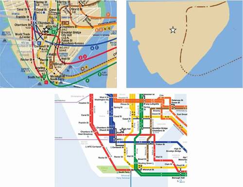
Regardless of visual detail, it is generally agreed that displays should avoid visual clutter. Visual clutter can be defined as task-irrelevant visual information that distracts the user’s attention from task-relevant features, resulting in less accurate inferences or longer reaction times (Fabrikant, Hespanha & Hegarty, Citation2010; Hegarty, Canham & Fabrikant, Citation2010; Rosenholtz, Li & Nakano, Citation2007; Wilkening & Fabrikant, Citation2011). It includes multiple defining components, such as (1) feature congestion – the ability of a newly added item to draw attention; (2) subband entropy – the efficiency at which an image can be processed while maintaining quality, where higher entropy means that lesser prediction of the features of an item from the features of items close by in the display; and (3) edge density – the percentage of pixels in the display that are edge pixels (Rosenholtz et al., Citation2007). Visual clutter becomes an even greater problem when the user needs to gather information quickly by glancing, since peripheral vision is especially vulnerable to visual clutter (see ). Given this problem, the texture tiling model – a computational vision model that generates images with a simulated peripheral vision loss during eye fixations – is a powerful tool for assessing when displays may fail, particularly if the displays need to be used during multitasking or time-sensitive scenarios (Rosenholtz, Citation2016, Citation2020). Put simply, a third design principle suggests that navigation systems should avoid presenting non-essential information and should minimize visual clutter.
Figure 1. The phenomena of visual crowding in peripheral vision. Peripheral vision is extremely vulnerable to nearby clutter. Fixating on the white star in the top panel, it is very hard to see the path of the brown subway line. The task becomes trivially easy when other visual elements are removed, as in the rightmost panel. The task simplifies when the map is more abstract and less cluttered, even though the map is less geographically accurate (Berman, Citation2018). Top left and right figures reprinted with permission from Rosenholtz and Yu (Citation2019). Bottom panel, Marco Vignelli inspired design, Wikipedia.org.
2.2.2. Providing directions and spatial language
Even if the visual display of a navigation system is well-designed, there remains the issue of verbally communicating directions and additional orientation information to the user to supplement the screen-based information. Many digital navigation assistants, such as Google Maps, provide turn-by-turn directions containing metric information, such as, “in 100 feet, turn left.” However, these turn-by-turn directions typically contain little or no information about local or global landmarks in the environment, and assume that the user makes correct judgments about when and where to turn based on metric estimation (such as distance to a nearby intersection). In reality, when people provide directions to others in navigation, they often refer to landmarks and crucial decision points using gesture-based and natural language descriptions (Schroder, Mackaness & Gittings, Citation2011; Tenbrink & Winter, Citation2009; Weissensteiner & Winter, Citation2004). These types of directions could be either chunking-based, which combine different route elements to inform the navigator about the next decision point (e.g., “turn right at the church after passing two streets”), or orientation-based, which provide local (near space) and global (far space) landmark information (Anacta, Schwering, Li & Muenzer, Citation2017; Klippel, Citation2003; Klippel, Hansen, Richter & Winter, Citation2009; Krukar, Anacta & Schwering, Citation2020; Schwering, Li & Anacta, Citation2013).
How should navigation systems provide directions? Klippel (Citation2003) found that both Germans and Americans employ various directional chunking strategies to generate route directions, such as landmark chunking (“turn right at the main building, go straight after the church”), numerical chunking (“turn right at the second intersection, it’s the third street to the right”), or structure chunking (“turn right at the roundabout”). Even though there is evidence that these types of descriptions are routinely used in natural language directions across cultures, there has been relatively little empirical work assessing their effectiveness in supporting spatial learning and wayfinding. Recently, Krukar et al. (Citation2020) compared the effects of turn-by-turn directions (“turn right onto Clark St. in 500 meters”), chunking-based directions (“turn right at the church after passing the school”), and orientation-based directions (referring to global landmarks such as the city center; “go around the city center towards the church, then go through the park”) on the recipient’s spatial learning. They found that chunking-based and orientation-based directions improved spatial learning compared with turn-by-turn directions. Furthermore, orientation-based directions resulted in better survey knowledge than chunking-based directions without compromising route knowledge. In tandem, this research suggests a fourth design principle: that navigation systems should implement chunking or orientation information in their directions, or, at least, allow users to choose task-appropriate directions depending on the relevance of global information.
Other researchers have focused on the general role of landmarks in verbal navigational directions (see Richter & Winter, Citation2014, for a review). People typically express a desire for landmark inclusion in directions, particularly when encountering critical decision and re-orientation points in the environment, such as intersections or globally visible landmarks (Denis, Michon & Tom, Citation2007; Michon & Denis, Citation2001; Snowdon & Kray, Citation2009). Directions that cue navigators to landmarks help to increase navigational efficiency and spatial learning, particularly when salient landmarks are emphasized (Klippel & Winter, Citation2005; Nothegger, Winter & Raubal, Citation2004; Richter, Citation2007; Schwering et al., Citation2013). Including landmark information in directions improves both pedestrians’ and drivers’ procedural and configural spatial learning, particularly at navigation decision points (Gramann, Hoepner & Karrer-Gauss, Citation2017; Wunderlich & Gramann, Citation2019).
At the same time, landmark cueing can also lead to difficulties or disorientation. For example, when there are multiple turns available at critical decision points, navigators become confused about the correct turning point (Hirtle, Richter, Srinivas & Firth, Citation2010; Tomko & Richter, Citation2015). However, these errors can be minimized by focusing directional cueing on landmarks that are salient (such as a major city hall) or provided by the user explicitly (Krieger, Kattenbeck, Ludwig, Helmbrecht & Giannopoulos, Citation2020; Tenbrink, Citation2018). Further, urban planners have recommended tailoring urban design so that it supports mobile map users, by building simple junctions with landmarks that are easily recognizable at intersection corners (Ahmadpoor & Smith, Citation2020; Ahmadpoor, Smith & Heath, Citation2021). Based on this research, we suggest a fifth design principle: that navigation systems explicitly cue users to decision-relevant and salient landmarks in the environment. A challenge for future research includes providing landmark information for global, off-route, off-screen, and non-visible landmarks (Dillemuth, Citation2009; Krukar, Mavros & Hoelscher, Citation2020; see the section on “Providing accessible global and orientation information” for further discussion).
2.2.3. Usability and accessibility
Making navigation systems more accessible and multimodal for people with sensory impairments will facilitate navigation for many users and in various navigation contexts. Although the major source of information for spatial cognition and navigation is often visual, environmental information is intrinsically multimodal and the human brain encodes spatial layout in a modality independent manner (Huffman & Ekstrom, Citation2019; Wolbers, Klatzky, Loomis, Wutte & Giudice, Citation2011). A large body of evidence suggests a functional equivalence between vision and other senses due to common perception, processing, and representation of spatial information between the senses; for example, highly similar navigation performance can be attained when learning is based on visual cues and haptic or auditory cues (see Giudice, Citation2018, for a review). This suggests that navigation devices should provide redundant spatial information to most effectively support the user’s navigation, and that visual information is not necessarily better for supporting navigation than information from other sensory modalities.
Much of the navigation system literature has focused on making this technology accessible to blind and visually impaired (BVI) people. Navigation by BVI travellers poses several practical problems, such as obstacle avoidance and spatial updating using varying levels of residual vision and non-visual cues (Barhorst-Cates, Rand & Creem-Regehr, Citation2017; Giudice, 2018; Rand, Creem-Regehr & Thompson, Citation2015; Schinazi, Thrash & Chebat, Citation2016). Although canes and guide dogs are efficient for solving the problems of mobility and obstacle avoidance, obtaining relevant information about global landmarks and environmental configurations and updating or maintaining one’s orientation in the environment remain difficult and cognitively effortful tasks for BVI travellers, something that can be greatly assisted through the use of navigation systems to aid in providing updated orientation information (Giudice & Legge, Citation2008). BVI navigators often only have access to route information since (1) non-visual sensing (and degraded visual access) is limited to the immediate environment, meaning access to off-route information is generally limited and error prone (Giudice & Long, Citationin press) and (2) most navigation systems only provide route instructions, rather than global environmental information. However, the most accurate navigation and orientation behavior requires knowledge of both route information and off-route environmental configuration, as this allows for an understanding of spatial relations and global layout, which is important for supporting spatial inference, route detours, cognitive mapping, and other complex spatial behaviors (Ahmadpoor & Shahab, Citation2019; Shelton, Marchette & Furman, Citation2013). For this reason, navigation systems that provide access to off-route information or that include the use of complementary accessible maps are particularly important for this community. Knowledge about global orientation cues and physical mobility information are rarely available to blind users from an integrative navigation system and it is important to determine how that information should be presented. Three options that have been extensively tested are spatial language, touch, and spatialized acoustics (see Gallay, Denis & Auvray, Citation2013, for a review).
Learning via spatial language can support exploration and goal-directed wayfinding, not just route following. For instance, describing local landmarks and layout configuration in an updated manner (e.g., with respect to the navigator’s changing heading and position in the environment as they move) facilitates learning of off-route knowledge such as self-to-object relations and global structure (Giudice, Bakdash & Legge, Citation2007). More recently, Giudice, Whalen, Riehle, Anderson and Doore (Citation2019) found that a navigation device providing spatial descriptions assisted a group of blind individuals in navigating complex, multifloor indoor environments, similarly to a sighted group who had visual access to the same information (Giudice et al., Citation2020, Citation2019). Importantly, blind individuals performed much better when this information was accessible during wayfinding compared with when the same information was only accessible during route planning.
Touch-based feedback has been implemented successfully in navigation systems for people with visual impairments, and has historically taken the form of raised-line paper maps, force feedback, or cutaneous feedback via joysticks, mice, buttons, and pins (Ducasse, Brock & Jouffrais, Citation2018). Yet touch feedback presents unique challenges on mobile touchscreen devices, which have a smooth, 2D surface. Klatzsky, Giudice, Bennett, & Loomis (Citation2014) recommended combining touch-based and auditory information, given that sound spectrum information contains and can convey spatial location information (Auvray, Hanneton & O’Regan, Citation2007; Klatzky et al., Citation2014). Another option involves combining touch-based vibration information with descriptions in spatial language. Recent evidence using such a system suggests that a vibro-audio map, rendered on the touchscreen of a smartphone, results in better wayfinding efficiency and route knowledge development than a traditional raised-line tactile map of the same area, even when the auditory information is equivalent between the two interfaces (Giudice, Guenther, Jensen & Haase, Citation2020; see also Brock, Truillet, Oriola & Jouffrais, Citation2010; Brock, Truillet, Oriola, Picard & Jouffrais, Citation2015).
There are instances where a specific modality provides advantages for BVI navigators. For instance, spatial sound (sonification) results in better navigation performance than spatial language for BVI people when navigation is conducted under cognitive load (Klatzky, Marston, Giudice, Golledge & Loomis, Citation2006). More generally, sonification results in shorter wayfinding times, more accurate spatial memory, and more favorable subjective experience ratings than spatial language instructions (Clemenson, Maselli, Fiannaca, Miller & Gonzalez-Franco, Citation2021; Loomis, Golledge & Klatzky, Citation2001; Marston, Loomis, Klatzky, Golledge & Smith, Citation2006). This line of research suggests that multisensory user interfaces are important for the design of navigation systems, as they (1) support a bio-inspired design philosophy built on how the brain actually performs spatial information processing and representation, and (2) allow for maximum potential user benefit, for example, universal design, essentially designing with the idea that supporting disability is simply the outcome of supporting diversity of users in the design process. Thus, this research suggests a sixth design principle: to adopt design conventions that provide redundant, accessible information using multiple sensory modalities (e.g., visualization, text, and auditory information).
While we highlighted a rich history of research on building more accessible navigation systems for BVI users, there remains a vast array of challenges given common map applications’ overreliance on visual information and gesture-based feedback. Froehlich and colleagues recently began a special interest group“Making Maps Accessible and Putting Accessibility in Maps” which hopes to tackle the challenge of providing more pedestrian, accessibility-focused information in map applications (Brock et al., Citation2018; Froehlich et al., Citation2019).
Froehlich et al. (Citation2019) segment user abilities into three categories: sensory, cognitive, and physical. Each set of ability should be considered separately during design in order to ensure that the navigation system can be used by the widest array of users, that is, support the core tenet of universal design. In particular, the group notes that while strides in accessibility for low vision individuals have been made, much less research has been done around physical accessibility (e.g., Tannert & Schöning, Citation2018) and cognitive accessibility (e.g., language comprehension, attentional, or memory degradation issues). Age is a great example, as people over 65 are the fastest growing demographic (at least in the United States), and experience many (often co-existing) changes in sensory, memory, attentional, and other cognitive factors, but are little studied in the domain of navigation. A few applications, such as Opensidewalks.com and Wheelmap are in early development, but have sparse data and are in need of further research (see Froehlich et al., Citation2019, for more). This leads us to form a seventh principle of navigation system design, that systems should provide physical accessibility information, such as availability of wheelchair-friendly routes.
Deaf individuals also require different design principles in order to facilitate effective navigation. While deaf individuals can utilize visual map applications and read directions, this becomes difficult when environmental monitoring or a secondary task (e.g. driving) is co-occurring with navigation. To reduce cognitive load due to risk monitoring and facilitate effective navigation, wearable devices are being developed that classify environmental sounds and describe their content and location using textual descriptions and vibrational feedback (Findlater et al., Citation2019; Jain et al., Citation2020). Research is in the early stages of development for navigation systems in this area and presents a major opportunity for future investigation. This brings us to an eighth design principle: navigation systems should strive to provide information about non-visual orientation cues, such as auditory, tangible, and olfactory/smell properties of the environment.
Differences in cognitive abilities and other factors, such as dementia due to aging, also require specific design constraints to fit user needs. For older individuals, general declines in cognitive and sensory functioning (e.g., visual acuity, working memory, and linguistic comprehension) have to be considered when designing navigation systems (see Wiener & Pazzaglia, Citation2021, for a comprehensive review of aging-friendly navigation design). Users’ varying cognitive abilities and constraints suggest a ninth and final design principle: that navigation systems should strive to minimize users’ cognitive load when possible, and at the least avoid cognitive overload. Recent work has developed simulation models for non-digital navigation systems, such as signage and architectural design, in order to create easy to navigate environments with accessible signage (Dubey, Thrash, Kapadia, Hoelscher & Schinazi, Citation2019; Gath-Morad, Aguilar, Dalton & Holscher, Citation2020). For individuals with intellectual and cognitive disabilities, augmented reality has shown better spatial learning and wayfinding outcomes compared to Google Maps and paper maps, but there is a dearth of research in this domain and future work and application development is needed (Gomez et al., 2015; McMahon et al., 2015; Smith et al., 2017). Simulation, virtual reality, and augmented reality offer promising mediums for assessing low-cost navigation system prototypes prior to implementation in real-world systems.
Importantly, there is not necessarily a “one size fits all” solution for making devices more accessible, nor is there a best implementation strategy or user interface modality (Loomis, Klatzky, Giudice, Manduchi & Kurniawan, Citation2012). Rather, navigation systems should be tested extensively with respect to user abilities and task-based needs, and provide empirically validated options that suit the user and situation. Making systems more accessible will contribute to making them easier and more enjoyable to use for all types of users, and following the recommendations in the above principles will go a long way towards supporting more inclusive design.
3. Lessons learned, open questions, and opportunities for future research
3.1. Mobile navigation system design principles
Our review helped to generate design principles for mobile navigation systems based on past empirical work that will ensure that future systems are more accessible and usable for all navigators. In summary, mobile navigation systems should strive to:
Provide the option to present both route (e.g., information about local turns) and global orientation information (e.g., information about global landmarks and cardinal directions).
Allow users to easily choose a preferred map alignment, such as track-up or north-up.
Avoid presentation of non-essential information and visual clutter.
Implement chunking and orientation information in verbal directions, or, at least, allow users to choose directions based on the importance of global spatial information to the user’s goals. Chunking can be landmark-based (“turn left at the church after passing the school”), numeric (“turn left after passing the second intersection”), or a combination of the two.
Cue users to decision-relevant, perceptually-salient landmarks in the environment. Decision-relevant landmarks include those at intersections and other junctions, while perceptually-salient landmarks could include structurally prominent landmarks such as a city hall, or landmarks specified by the user that are memorable or salient to them.
Adopt design conventions that provide redundant, accessible information using multiple sensory modalities (e.g., visualization, text, and auditory). Sonification and use of vibrotactile information on commercially available smart devices (phones or tablets) is especially promising for facilitating spatial learning for low-vision and blind individuals.
Provide physical accessibility information, such as wheelchair-friendly routes.
Provide information about non-visual orientation cues (e.g., sound, tactile, and smell properties of the environment).
Minimize users’ cognitive load when possible, and at the least avoid cognitive overload (e.g., providing too much information in concurrence such that it is not useful, able to be efficiently filtered, or able to be remembered by the user).
What challenges remain, and where is mobile navigation systems research headed? We briefly discuss three major challenges and potential approaches: adjusting for context, providing accessible global orientation information, and providing insights into navigation processes and development over time.
3.2. Adjusting for context
Years of spatial cognition and navigation research point to vast individual differences in navigational abilities (Ishikawa & Montello, Citation2006; Montello, Citation1998; Weisberg & Newcombe, Citation2018) and situational strategies (e.g., navigating under stress; Credé, Thrash, Hölscher & Fabrikant, Citation2019; Frei, Richter & Fabrikant, Citation2016; Gagnon et al., Citation2018; Ruginski, Stefanucci & Creem-Regehr, Citation2018). Designing navigation systems that take into account and adapt to these individual abilities, preferences, and contexts remains a challenge. Several contextual design recommendations have been recently proposed (Thrash et al., Citation2019), outlined in . For example, landmarks could be emotionally relevant due to the observer’s emotional state or to the emotional valence of the landmark itself (Balaban, Roser & Hamburger, Citation2014) and may change performance. Measures of individual differences in preference and performance rely on self-report or behavioral responses and can inform the route elements presented.
Table 1. Design recommendations for geographic information display (GID) elements based on context. originally appearing in (Thrash et al., Citation2019)
Many researchers have demonstrated that mobile navigation systems result in poorer spatial learning as the result of reducing cognitive workload and diverting attention from the environment (Brugger et al., 2019, Parush, Ahuvia & Erev, Citation2007). But often, navigation systems are designed with the purpose of making wayfinding as easy and efficient as possible, often during a concurrent task, such as driving. At the same time, navigation systems can be used by pedestrians similarly to a map, where spatial learning is the primary goal, and not necessarily arriving at a wayfinding goal as quickly as possible. The negative effects of navigation systems on spatial learning are likely only problematic if they (1) contribute to a cognitive decline more generally and causally over a long time period, or (2) affect the user’s wayfinding goals and user experience negatively. Because of this, it is important to further study the interaction between navigation systems and wayfinders’ goals in real-world contexts. Designing navigation systems to serve various navigation contexts and understanding how navigation systems affect users’ differing wayfinding goals is an important area for future research.
3.3. Providing accessible global and orientation information
3.3.1. Restricted displays and global information
Limited screen space is a major challenge when displaying maps on mobile navigation systems. Many modern map applications such as Google Maps and OpenStreetMap allow users to dynamically change map scale by panning and zooming. Still, global landmarks may be difficult to find efficiently using map panning and zooming operations. Some methods have sought to solve this issue by portraying landmark information on the borders of device screens, which provides additional information about landmarks that are not in view (Baudisch & Rosenholtz, Citation2003; Li, Citation2019; Schwering, Krukar, Li, Anacta & Fuest, Citation2017).
Even if an optimal visualization is chosen, selecting which specific landmarks to display has important implications for spatial learning and wayfinding. Löwen, Krukar and Schwering (Citation2019) found that highlighting local landmarks on a mobile map supported route knowledge acquisition, whereas highlighting global landmarks supported survey knowledge acquisition. Systems have also been developed that change the level of detail of navigational directions depending on the stage of the navigator’s route (Klippel et al., Citation2009; Tenbrink & Winter, Citation2009). One recent solution implements guiding arrows that point to off-screen goal landmarks on navigation systems, and has promise as a solution to achieve both efficient navigation and effective spatial learning (Maidenbaum, Patel, Gedankien & Jacobs, Citation2020). Implementing off-screen, global landmark visualization in real time will be a challenge for future work, considering the problems of contextual landmark selection, varying landmark granularity, and non-visual navigation system design (Palani, Giudice & Giudice, Citation2016; Rastogi, Pawluk & Ketchum, Citation2013; Schwering et al., Citation2017).
3.3.2. When GPS is challenging, noisy, or unavailable
Many challenges with retrieving global positioning information have been largely solved by the increasing availability of location-based services to support navigation (Hirtle & Raubal, Citation2013). GPS devices often possess fairly accurate knowledge of the world assuming the signal arrives to the device, and can provide this information via mobile map applications, such as Google Maps. When there is uncertainty in GPS signalling, research suggests the viability of visualizing position using blurry visual boundaries and providing users with additional information about local environmental cues to aid self-localization (McKenzie, Hegarty, Barrett & Goodchild, Citation2016; Ranasinghe, Heitmann, Hamzin, Pfeiffer & Kray, Citation2018; Ranasinghe et al., Citation2018; Ranasinghe & Kray, Citation2018).
Location information remains especially challenging to provide for indoor environments due to technological limitations (no consistent GPS signals or inconsistent building maps) and perceptual limitations (limited sight lines or multiple floors) (Basiri et al., Citation2017; Giudice et al., Citation2019; Riehle, Anderson, Lichter, Whalen & Giudice, Citation2013). A recently developed solution, NavCog, utilizes Bluetooth beacons to provide turn-by-turn, point of interest, and accessibility information for effective indoor navigation using auditory cues (Ahmetovic et al., Citation2016). To our knowledge, there are no standards or broadly accepted conventions for indoor GIS and digital building maps, leaving this an open research area ripe for future work.
3.4. Providing insights into navigation processes
Beyond determining whether navigation systems affect wayfinding efficiency and spatial knowledge positively or negatively, future research should systematically examine how navigation systems affect navigation processes and different levels of spatial knowledge. This will help clarify system effectiveness within specific contexts. For example, a navigation system used in a car might be “good enough” and facilitate efficient navigation even if the driver only gains sequential knowledge of turns. We present a summary of previously validated measures of spatial learning and navigation efficiency in , and hope that it is helpful to researchers who aim to empirically evaluate navigation systems.
Table 2. Behavioral measures of spatial learning and navigation efficiency
Future work should also incorporate more ecologically valid, real-world usage contexts to increase generalization of results. In these cases, wayfinding trajectories, specifics of application use, familiar environment knowledge, and learning of new environments could all be measured or manipulated to increase insights into behavior–system–environment interactions. For example, mobile eye tracking has been proposed as a rich tool to measure individuals’ dynamic wayfinding behaviors using navigation systems (Kiefer, Giannopoulos, Raubal & Duchowski, Citation2017; Kiefer, Straub & Raubal, Citation2012) and to model gaze-based landmark salience (Krukar et al., Citation2020; Wang, Chen, Zheng, Yuan & Wang, Citation2020). In addition, MapRecorder is a recently developed tool that provides insights into interaction with common navigation systems such as Google Maps (Savino et al., 2020)
The effects of navigation systems on navigational processes throughout the lifespan also need to be further investigated (Unrau & Kray, Citation2019). To our knowledge, there is still no causal evidence of long-term detriments to spatial cognitive abilities from navigation system use, and thus a need for longitudinal studies to assess open questions of causality based on within-person, repeated-measures experimental designs (Newsom, Citation2015). In this line of work, device use can be monitored over periods of weeks, months, or years to better understand how devices affect spatial cognition over time, as well as how users adapt to device interfaces over time. This research will also help expand an understanding of navigation in familiar environments, even though most studies cited in this review assess navigation in unfamiliar environments.
4. Introduction to the special issue
The current special issue features six articles, in addition to the present introductory review article, that contribute to open questions regarding the study of mobile navigation systems. These articles take on important questions in the areas of navigation systems regarding navigation behavior in an emergency context (Snopkova et al.), provision of navigational directions on navigation systems (DeCock et al.; Kattenbeck et al.), and visual design of navigation system maps (Gardony et al.; Smith et al.; Sugimoto et al.).
Research included in the issue broadly shows that context plays an important role in wayfinding with navigation systems. Snopkova et al examined people’s route choice in emergency evacuation using virtual-reality simulation. They found that the tendency to apply a route-retracing strategy was lower when a designated evacuation path was wide and straight. Also, availability of a floor plan during evacuation facilitated the choice of a designated evacuation path. These results provide implications for the design of a building and the provision of evacuation information with an understanding of people’s spatial behavior in emergency situations. De Cock et al. found that navigation instructions reduce wayfinding errors to a greater degree when wayfinding instructions are adapted to the type of decision point in the environment, compared to when the same type of instructions is used across all decision points – suggesting that systems should provide different types of instructions based on environmental context. Kattenbeck et al. examined when and where to provide landmark-based navigational instructions to the traveller along a route, with a view to developing automated navigation tools. They found that preferred timing of route instructions was related to personality traits, orientation abilities, route length, land cover types, and familiarity. The results shed light on the discussion of user-adapted and context-aware navigation assistance.
The next series of papers examined the effects of visual map design on wayfinding with navigation systems. Smith et al. developed two different types of mobile maps that depicted off-screen landmarks as symbols and varied whether the maps had game-like dynamic updating of symbols versus fixed locations of symbols. Using a route-following task in a real-world city and a task of pointing to previously visited landmarks, their findings suggest that dynamically updating landmark locations on a map can facilitate abilities to update one’s spatial location and orientation along a novel route. They also discuss the benefits and challenges of interdisciplinary and mixed-methods approaches across geospatial science and experimental psychology. Further, Gardony et al. assessed the impact of graphical detail of 3D terrain models on spatial localization and orientation in large-scale environments. Their surprising results, based on an interactive geo-visualization paradigm, showed that rendering a moderate (rather than maximum) level of detail was sufficient for supporting these behaviours. Findings were used to motivate new perceptually-driven guidelines for collecting and communicating 3D terrain models for accurate end-user visualization of spatial data.
Lastly, Sugimoto et al. compared people’s spatial memory and navigation performance when they learned route using a smartphone map and a paper map. Their results demonstrated that route learning was reliably less accurate when using the smartphone map. Of interest however, this performance deficit was not perceptually obvious to the participants, as their self-evaluation data revealed no significant differences between the two map conditions on ratings of state anxiety and confidence. These findings suggest that users are not only worse when using smartphone-based maps but that they are unaware of the learning and memory impairments caused by the use of this technology.
The study of navigation systems is a wide-ranging, interdisciplinary effort that has only just begun given the increasing complexity of digital navigation systems. While some may argue that overreliance on GPS devices is problematic for navigational skills, our review finds a more nuanced story – that navigation systems can aid wayfinding and spatial learning when designed based on theories of human behaviour, perception, and cognition; which in turn makes the devices more accessible. For instance, they should provide access to landmarks and be inclusively designed to support users of varying abilities in their desired navigation goals. To further research in this area, we provide design principles and tangible goals for future work considering remaining research challenges. Our special issue is a first step in this direction, containing multiple studies across disciplines addressing open questions in the study of navigation systems.
Acknowledgments
We thank the expert reviewers and the authors who contributed to the present special issue, as well as the handling editor in chief Dan Montello, who supported our publishing and editing of the special issue.
Disclosure statement
No potential conflict of interest was reported by the author(s).
Additional information
Funding
References
- Ahmadpoor, N., & Shahab, S. (2019). Spatial knowledge acquisition in the process of navigation: A review. Current Urban Studies, 7(1), 1–19. doi:10.4236/cus.2019.71001
- Ahmadpoor, N., & Smith, A. D. (2020). Spatial knowledge acquisition and mobile maps: The role of environmental legibility. Cities, 101, 102700. doi:10.1016/j.cities.2020.102700
- Ahmadpoor, N., Smith, A. D., & Heath, T. (2021). Rethinking legibility in the era of digital mobile maps: an empirical study. Journal of Urban Design, 26(3), 296–318. doi:10.1080/13574809.2020.1777847
- Ahmetovic, D., Gleason, C., Ruan, C., Kitani, K., Takagi, H., & Asakawa, C. (2016). NavCog: A navigational cognitive assistant for the blind. In Proceedings of the 18th International Conference on Human-Computer Interaction with Mobile Devices and Services, pp. 90–99. 10.1145/2935334.2935361
- Anacta, V. J. A., Schwering, A., Li, R., & Muenzer, S. (2017). Orientation information in wayfinding instructions: evidences from human verbal and visual instructions. GeoJournal, 82(3), 567–583. doi:10.1007/s10708-016-9703-5
- Arleo, A., & Rondi-Reig, L. (2007). Multimodal sensory integration and concurrent navigation strategies for spatial cognition in real and artificial organisms. Journal of Integrative Neuroscience, 6(3), 327–366. doi:10.1142/S0219635207001593
- Auvray, M., Hanneton, S., & O’Regan, J. K. (2007). Learning to perceive with a visuo-auditory substitution system: localisation and object recognition with ‘The Voice. Perception, 36(3), 416–430. doi:10.1068/p5631
- Balaban, C. Z., Roser, F., & Hamburger, K. (2014). The effect of emotions and emotionally laden landmarks on wayfinding. In Proceedings of the Annual Meeting of the Cognitive Science Society July 23-26 Quebec City, Canada, 36 2 September 2021. Retrieved from https://escholarship.org/uc/item/4p60r568
- Barhorst-Cates, E. M., Rand, K. M., & Creem-Regehr, S. H. (2017). Let me be your guide: physical guidance improves spatial learning for older adults with simulated low vision. Experimental Brain Research, 235(11), 3307–3317. doi:10.1007/s00221-017-5063-8
- Basiri, A., Lohan, E. S., Moore, T., Winstanley, A., Peltola, P., Hill, C., … Silva, P. (2017). Indoor location based services challenges, requirements and usability of current solutions. Computer Science Review, 24, 1–12. doi:10.1016/j.cosrev.2017.03.002
- Baudisch, P., & Rosenholtz, R. (2003). Halo: A technique for visualizing off-screen locations. New Horizons, 5, 8.
- Berman, J. (2018). Marco Vignelli–inspired New York subway map [svg image 5 May 2020]. https://commons.wikimedia.org/wiki/File:NYC_subway-4D.svg
- Bienk, S., Kattenbeck, M., Ludwig, B., Müller, M., & Ohm, C. (2013). I want to view it my way: Interfaces to mobile maps should adapt to the user’s orientation skills. In Proceedings of the 12th International Conference on Mobile and Ubiquitous Multimedia, 34, pp. 1–9. 10.1145/2541831.2541841
- Brock, A. M., Froehlich, J. E., Guerreiro, J., Tannert, B., Caspi, A., Schöning, J., & Landau, S. (2018). SIG: Making maps accessible and putting accessibility in maps. In Extended Abstracts of the 2018 CHI Conference on Human Factors in Computing Systems, 1–4. 10.1145/3170427.3185373
- Brock, A., Truillet, P., Oriola, B., & Jouffrais, C. (2010). Usage of multimodal maps for blind people: Why and how. In ACM International Conference on Interactive Tabletops and Surfaces, pp. 247–248. 10.1145/1936652.1936699.
- Brock, A. M., Truillet, P., Oriola, B., Picard, D., & Jouffrais, C. (2015). Interactivity improves usability of geographic maps for visually impaired people. Human–Computer Interaction, 30(2), 156–194. doi:10.1080/07370024.2014.924412
- Brügger, A., Richter, K.-F., & Fabrikant, S. I. (2019). How does navigation system behavior influence human behavior? Cognitive Research: Principles and Implications, 4(1), 5. doi:10.1186/s41235-019-0156-5
- Chrastil, E. R., Nicora, G. L., & Huang, A. (2019). Vision and proprioception make equal contributions to path integration in a novel homing task. Cognition, 192, 103998. doi:10.1016/j.cognition.2019.06.010
- Chrastil, E. R., & Warren, W. H. (2013). Active and passive spatial learning in human navigation: Acquisition of survey knowledge. Journal of Experimental Psychology. Learning, Memory, and Cognition, 39(5), 1520–1537. doi:10.1037/a0032382
- Clemenson, G. D., Maselli, A., Fiannaca, A., Miller, A., & Gonzalez-Franco, M. (2021). Rethinking GPS navigation: Creating cognitive maps through auditory clues. Scientific Reports, 11(1), 7764. doi:10.1038/s41598-021-87148-4
- Coughlan, G., Laczó, J., Hort, J., Minihane, A.-M., & Hornberger, M. (2018). Spatial navigation deficits: Overlooked cognitive marker for preclinical Alzheimer disease? Nature Reviews. Neurology, 14(8), 496–506. doi:10.1038/s41582-018-0031-x
- Credé, S., Thrash, T., Hölscher, C., & Fabrikant, S. I. (2019). The acquisition of survey knowledge for local and global landmark configurations under time pressure. Spatial Cognition and Computation, 19(3), 190–219. doi:10.1080/13875868.2019.1569016
- Dahmani, L., & Bohbot, V. D. (2020). Habitual use of GPS negatively impacts spatial memory during self-guided navigation. Scientific Reports, 10(1), 6310. doi:10.1038/s41598-020-62877-0
- Delikostidis, I., Engel, J., Retsios, B., Van Elzakker, C. P., Kraak, M. J., & Döllner, J. (2013). Increasing the usability of pedestrian navigation interfaces by means of landmark visibility analysis. The Journal of Navigation, 66(4), 523–537. doi:10.1017/S0373463313000209
- Delikostidis, I., van Elzakker, C. P. J. M., & Kraak, M.-J. (2016). Overcoming challenges in developing more usable pedestrian navigation systems. Cartography and Geographic Information Science, 43(3), 189–207. doi:10.1080/15230406.2015.1031180
- Denis, M., Michon, P. E., & Tom, A. (2007). Assisting pedestrian wayfinding in urban settings: why references to landmarks are crucial in direction-giving. In G. L. Allen (Ed.), Applied spatial cognition: From research to cognitive technology (pp. 25–51). Hove, East Sussex, United Kingdom: Psychology Press.
- Dillemuth, J. (2005). Map design evaluation for mobile display. Cartography and Geographic Information Science, 32(4), 285–301.
- Dillemuth, J. A. (2009). Navigation tasks with small-display maps: the sum of the parts does not equal the whole. Cartographica: The International Journal for Geographic Information and Geovisualization, 44(3), 187–200. doi:10.3138/carto.44.3.187
- Dubey, R. K., Thrash, T., Kapadia, M., Hoelscher, C., & Schinazi, V. R. (2019). Information theoretic model to simulate agent-signage interaction for wayfinding. Cognitive Computation, 13(1), 189–206. doi:10.1007/s12559-019-09689-1
- Ducasse, J., Brock, A. M., & Jouffrais, C. (2018). Accessible interactive maps for visually impaired users. In E. Pissaloux & R. Velazquez (Eds.), Mobility of visually impaired people (pp. 537–584). Springer International. doi:10.1007/978-3-319-54446-5_17
- Fabrikant, S. I., Hespanha, S. R., & Hegarty, M. (2010). Cognitively inspired and perceptually salient graphic displays for efficient spatial inference making. Annals of the Association of American Geographers, 100(1), 13–29. doi:10.1080/00045600903362378
- Findlater, L., Chinh, B., Jain, D., Froehlich, J., Kushalnagar, R., & Lin, A. C. (2019 Deaf and hard-of-hearing individuals' preferences for wearable and mobile sound awareness technologies 2019 CHI Conference on Human Factors in Computing Systems May 5-9, 2019 Glasgow, Scotland). 22 May 2020.
- Freeman, E., Wilson, G., Vo, D. B., Ng, A., Politis, I., & Brewster, S. (2017). Multimodal feedback in HCI: Haptics, non-speech audio, and their applications. The Handbook of Multimodal-multisensor Interfaces: Foundations, User Modeling, and Common Modality Combinations, 1, 277–317. ACM Books #14.
- Frei, P., Richter, K. F., & Fabrikant, S. I. (2016 Stress supports spatial knowledge acquisition during wayfinding with mobile maps. International conference on GiScience September 2016 Montreal, Canada). . In (Vol. , pp.). 4.
- Friedman, A., & Kohler, B. (2003). Bidimensional regression: Assessing the configural similarity and accuracy of cognitive maps and other two-dimensional data sets. Psychological Methods, 8(4), 68–91. doi:10.1037/1082-989X.8.4.468
- Froehlich, J. E., Brock, A. M., Caspi, A., Guerreiro, J., Hara, K., Kirkham, R., … Tannert, B. (2019). Grand challenges in accessible maps. Interactions, 26(2), 78–81. doi:10.1145/3301657
- Furman, A. J., Clements-Stephens, A. M., Marchette, S. A., & Shelton, A. L. (2014). Persistent and stable biases in spatial learning mechanisms predict navigational style. Cognitive, Affective & Behavioral Neuroscience, 14(4), 1375–1391. doi:10.3758/s13415-014-0279-6
- Gagnon, K. T., Thomas, B. J., Munion, A., Creem-Regehr, S. H., Cashdan, E. A., & Stefanucci, J. K. (2018). Not all those who wander are lost: Spatial exploration patterns and their relationship to gender and spatial memory. Cognition, 180, 108–117. doi:10.1016/j.cognition.2018.06.020
- Gallay, M., Denis, M., & Auvray, M. (2013). Navigation assistance for blind pedestrians: guidelines for the design of devices and implications for spatial cognition. In T. Tenbrink, J. M. Wiener, & C. Claramunt (Eds.), Representing space in cognition (pp. 244–267). Oxford University Press. doi:10.1093/acprof:oso/9780199679911.003.0011
- Gardony, A. L., Brunyé, T. T., Mahoney, C. R., & Taylor, H. A. (2013). How navigational aids impair spatial memory: Evidence for divided attention. Spatial Cognition and Computation, 13(4), 319–350. doi:10.1080/13875868.2013.792821
- Gath-Morad, M., Aguilar, L., Dalton, R. C., & Holscher, C. (2020). cogARCH: Simulating wayfinding by architecture in multilevel buildings. In SimAUD 2020 Symposium on Simulation for Architecture and Urban Design Online, 8, 1–8.
- Giudice, N. A., Bakdash, J. Z., & Legge, G. E. (2007). Wayfinding with words: Spatial learning and navigation using dynamically updated verbal descriptions. Psychological Research, 71(3), 347–358. doi:10.1007/s00426-006-0089-8
- Giudice, N. A., Betty, M. R., & Loomis, J. M. (2011). Functional equivalence of spatial images from touch and vision: Evidence from spatial updating in blind and sighted individuals. Journal of Experimental Psychology. Learning, Memory, and Cognition, 37(3), 621–634. doi:10.1037/a0022331
- Giudice, N. A., Guenther, B. A., Jensen, N. A., & Haase, K. N. (2020). Cognitive mapping without vision: Comparing wayfinding performance after learning from digital touchscreen-based multimodal maps vs. embossed tactile overlays. Frontiers in Human Neuroscience, 14, 87. doi:10.3389/fnhum.2020.00087
- Giudice, N. A., Guenther, B. A., Kaplan, T. M., Anderson, S. M., Knuesel, R. J., & Cioffi, J. F. (2020). Use of an indoor navigation system by sighted and blind travelers: Performance similarities across visual status and age. ACM Transactions on Accessible Computing, 13(3), 1–27. doi:10.1145/3407191
- Giudice, N. A., & Legge, G. E. (2008). Blind navigation and the role of technology. In A. S. Helal, M. Mokhtari, & B. Abdulrazak (Eds.), The engineering handbook of smart technology for aging, disability, and Independence (pp. 479–500). Wiley. doi:10.1002/9780470379424.ch25
- Giudice, N. A., & Long, R. G. (in press). Establishing and maintaining orientation: tools, techniques, and technologies. In Foundations of orientation and mobility (4th ed., Vol. 1, chap. 2). New York, NY: AFB Press.
- Giudice, N. A., Whalen, W. E., Riehle, T. H., Anderson, S. M., & Doore, S. A. (2019). Evaluation of an accessible, real-time, and infrastructure-freeindoor navigation system by users who are blind in the Mall of America. Journal of Visual Impairment & Blindness, 113(2), 140–155. doi:10.1177/0145482X19840918
- Golledge, R. G. (1978, December). Representing, interpreting, and using cognized environments. In Papers of the regional science association (Vol. 41(1), pp. 168–204). New York, NY: Springer
- Gramann, K., Hoepner, P., & Karrer-Gauss, K. (2017). Modified navigation instructions for spatial navigation assistance systems lead to incidental spatial learning. Frontiers in Psychology, 8, 8. doi:10.3389/fpsyg.2017.00193
- Hamburger, K., & Knauff, M. (2019). Odors can serve as landmarks in human wayfinding. Cognitive Science, 43(11), e12798. doi:10.1111/cogs.12798
- hard-of-hearing individuals’ preferences for wearable and mobile sound awareness technologies. In Proceedings of the 2019 CHI Conference on Human Factors in Computing Systems, pp. 1–13. 10.1145/3290605.3300276.
- Harwood, K., & Wickens, C. D. (1991). Frames of reference for helicopter electronic maps: the relevance of spatial cognition and componential analysis. The International Journal of Aviation Psychology, 1(1), 5–23. doi:10.1207/s15327108ijap0101_2
- Hegarty, M. (2013). Cognition, metacognition, and the design of maps. Current Directions in Psychological Science, 22(1), 3–9. doi:10.1177/0963721412469395
- Hegarty, M., Canham, M. S., & Fabrikant, S. I. (2010). Thinking about the weather: how display salience and knowledge affect performance in a graphic inference task. Journal of Experimental Psychology. Learning, Memory, and Cognition, 36(1), 37–53. doi:10.1037/a0017683
- Hegarty, M., Montello, D. R., Richardson, A. E., Ishikawa, T., & Lovelace, K. (2006). Spatial abilities at different scales: Individual differences in aptitude-test performance and spatial-layout learning. Intelligence, 34(2), 151–176. doi:10.1016/j.intell.2005.09.005
- Hejtmánek, L., Oravcová, I., Motýl, J., Horáček, J., & Fajnerová, I. (2018). Spatial knowledge impairment after GPS guided navigation: Eye-tracking study in a virtual town. International Journal of Human-Computer Studies, 116, 15–24. doi:10.1016/j.ijhcs.2018.04.006
- Hirtle, S. C., & Raubal, M. (2013). Many to many mobile maps. In M. Raubal, D. M. Mark, & A. U. Frank (Eds.), Cognitive and linguistic aspects of geographic space (pp. 141–157). Springer. doi:10.1007/978-3-642-34359-9_8
- Hirtle, S., Richter, K.-F., Srinivas, S., & Firth, R. (2010). This is the tricky part: when directions become difficult. Journal of Spatial Information Science, 1, 53–73. doi:10.5311/JOSIS.2010.1.5
- Huffman, D. J., & Ekstrom, A. D. (2019). A modality-independent network underlies the retrieval of large-scale spatial environments in the human brain. Neuron, 104(3), 611–622. doi:10.1016/j.neuron.2019.08.012
- Ishikawa, T. (2019). Satellite navigation and geospatial awareness: long-term effects of using navigation tools on wayfinding and spatial orientation. The Professional Geographer, 71(2), 197–209. doi:10.1080/00330124.2018.1479970
- Ishikawa, T., Fujiwara, H., Imai, O., & Okabe, A. (2008). Wayfinding with a GPS-based mobile navigation system: A comparison with maps and direct experience. Journal of Environmental Psychology, 28(1), 74–82. doi:10.1016/j.jenvp.2007.09.002
- Ishikawa, T., & Montello, D. (2006). Spatial knowledge acquisition from direct experience in the environment: individual differences in the development of metric knowledge and the integration of separately learned places. Cognitive Psychology, 52(2), 93–129. doi:10.1016/j.cogpsych.2005.08.003
- Ishikawa, T., & Takahashi, K. (2014). Relationships between methods for presenting information on navigation tools and users’ wayfinding behavior. Cartographic Perspectives, 75(75), 17–28. doi:10.14714/CP75.82
- Iwarsson, S., & Ståhl, A. (2003). Accessibility, usability and universal design: Positioning and definition of concepts describing person-environment relationships. Disability and Rehabilitation, 25(2), 57–66. doi:10.1080/dre.25.2.57.66
- Jacobs, L. F., Arter, J., Cook, A., & Sulloway, F. J. (2015). Olfactory orientation and navigation in humans. PLOS ONE, 10(6), e0129387. doi:10.1371/journal.pone.0129387
- Jain, D., Ngo, H., Patel, P., Goodman, S., Findlater, L., & Froehlich, J. (2020), October. SoundWatch: exploring smartwatch-based deep learning approaches to support sound wwareness for deaf and hard of hearing users. In The 22nd International ACM SIGACCESS Conference on Computers and Accessibility October 2020 Virtual Event Greece (pp. 1–13).
- Keil, J., Edler, D., Kuchinke, L., & Dickmann, F. (2020). Effects of visual map complexity on the attentional processing of landmarks. PLOS ONE, 15(3), e0229575. doi:10.1371/journal.pone.0229575
- Kiefer, P., Giannopoulos, I., Raubal, M., & Duchowski, A. (2017). Eye tracking for spatial research: Cognition, computation, challenges. Spatial Cognition and Computation, 17(1–2), 1–19. doi:10.1080/13875868.2016.1254634
- Kiefer, P., Straub, F., & Raubal, M. (2012). Location-aware mobile eye-tracking for the explanation of wayfinding behavior. In Proceedings of the AGILE’2012 International Conference on Geographic Information Science Lisbon, Portugal, 6.
- Klatzky, R. L., Giudice, N. A., Bennett, C. R., & Loomis, J. M. (2014). Touch-screen technology for the dynamic display of 2D spatial information without vision: Promise and progress. Multisensory Research, 27(5–6), 359–378. doi:10.1163/22134808-00002447
- Klatzky, R. L., Loomis, J. M., Golledge, R. G., Cicinelli, J. G., Doherty, S., & Pellegrino, J. W. (1990). Acquisition of route and survey knowledge in the absence of vision. Journal of Motor Behavior, 22(1), 19–43. doi:10.1080/00222895.1990.10735500
- Klatzky, R. L., Marston, J. R., Giudice, N. A., Golledge, R. G., & Loomis, J. M. (2006). Cognitive load of navigating without vision when guided by virtual sound versus spatial language. Journal of Experimental Psychology. Applied, 12(4), 223–232. doi:10.1037/1076-898X.12.4.223
- Klippel, A. (2003). Wayfinding choremes: Conceptualizing wayfinding and route direction elements. Bremen, Germany: University of Bremen Dissertations.
- Klippel, A., Hansen, S., Richter, K.-F., & Winter, S. (2009). Urban granularities: A data structure for cognitively ergonomic route directions. GeoInformatica, 13(2), 223–247. doi:10.1007/s10707-008-0051-6
- Klippel, A., Hirtle, S., & Davies, C. (2010). You-are-here maps: Creating spatial awareness through map-like representations. Spatial Cognition and Computation, 10(2–3), 83–93. doi:10.1080/13875861003770625
- Klippel, A., Tenbrink, T., & Montello, D. R. (2010). The role of structure and function in the conceptualization of directions. In E. van der Zee & M. Vulchanova (Eds.), Motion encoding in language and space. Oxford University Press. doi:10.1093/acprof:oso/9780199661213.003.0006
- Klippel, A., & Winter, S. (2005). Structural salience of landmarks for route directions. In A. G. Cohn & D. M. Mark(Eds., Spatial information theory (Vol. 3693, pp. 347–362). Springer doi:10.1007/11556114_22
- Krieger, P., Kattenbeck, M., Ludwig, B., Helmbrecht, J., & Giannopoulos, I. (2020). Hey you! Let’s talk. Dialogue-initiatives revisited for wayfinding instructions. AGILE: GIScience Series, 1, 1–19. doi:10.5194/agile-giss-1-11-2020
- Krukar, J., Anacta, V. J., & Schwering, A. (2020). The effect of orientation instructions on the recall and reuse of route and survey elements in wayfinding descriptions. Journal of Environmental Psychology, 68, 101407. doi:10.1016/j.jenvp.2020.101407
- Krukar, J., Mavros, P., & Hoelscher, C. (2020). Towards capturing focal/ambient attention during dynamic wayfinding. In ACM Symposium on Eye Tracking Research and Applications, 22, 1–5. 10.1145/3379157.3391417
- Lawton, C. A. (1994). Gender differences in way-finding strategies: Relationship to spatial ability and spatial anxiety. Sex Roles, 30(11–12), 765–779. doi:10.1007/BF01544230
- Li, R. (2019). Spatial learning in smart applications: Enhancing spatial awareness through visualized off-screen landmarks on mobile devices. Annals of the American Association of Geographers, 110(2), 421–433. doi:10.1080/24694452.2019.1670611
- Li, H., Corey, R. R., Giudice, U., & Giudice, N. A. (2016). Assessment of visualization interfaces for assisting the development of multi-level cognitive maps. In D. D. Schmorrow & M. C. Fidopiastis (Eds.), Proceedings of the 10th International Conference of Foundations of Augmented Cognition July 2016 Toronto, Canada (pp. 308–321). Springer International.
- Liao, H., Dong, W., Peng, C., & Liu, H. (2017). Exploring differences of visual attention in pedestrian navigation when using 2D maps and 3D geo-browsers. Cartography and Geographic Information Science, 44(6), 474–490. doi:10.1080/15230406.2016.1174886
- Loomis, J. M., Golledge, R. D., & Klatzky, R. L. (2001). GPS-based navigation systems for the visually impaired. In W. Barfield & T. Caudell (Eds.), Fundamentals of wearable computers and augmented reality (pp. 429–446). Mahwah, NJ: Erlbaum.
- Loomis, J. M., Klatzky, R. L., & Giudice, N. A. (2013). Representing 3D space in working memory: Spatial images from vision, hearing, touch, and language. In S. Lacey & R. Lawson (Eds.), Multisensory imagery (pp. 131–155). Springer. doi:10.1007/978-1-4614-5879-1_8
- Loomis, J. M., Klatzky, R. L., Giudice, N. A., Manduchi, R., & Kurniawan, S. (2012). Sensory substitution of vision: Importance of perceptual and cognitive processing. In R. Manduchi & S. Kurniawan (Eds.), Assistive technology for blindness and low vision (pp. 162–191). Boca Raton, FL: CRC Press.
- Loomis, J. M., Klatzky, R. L., Golledge, R. G., Pellegrino, J. W., Fry, P. A., & Fry, P. A. (1993). Nonvisual navigation by blind and sighted: Assessment of path integration ability. Journal of Experimental Psychology. General, 122(1), 73–91. doi:10.1037/0096-3445.122.1.73
- Löwen, H., Krukar, J., & Schwering, A. (2019). Spatial learning with orientation maps: The influence of different environmental features on spatial knowledge acquisition. ISPRS International Journal of Geo-Information, 8(3), 149. doi:10.3390/ijgi8030149
- Maidenbaum, S., Patel, A., Gedankien, T., & Jacobs, J. (2020). The effect of navigational aids on spatial memory in virtual reality. In 2020 IEEE Conference on Virtual Reality and 3D User Interfaces Abstracts and Workshops, pp. 645–646. 10.1109/VRW50115.2020.00173
- Marchette, S. A., Bakker, A., & Shelton, A. L. (2011). Cognitive mappers to creatures of habit: Differential engagement of place and response learning mechanisms predict human navigational behavior. Journal of Neuroscience, 31(43), 15264–15268. doi:10.1523/JNEUROSCI.3634-11.2011
- Marston, J. R., Loomis, J. M., Klatzky, R. L., Golledge, R. G., & Smith, E. L. (2006). Evaluation of spatial displays for navigation without sight. ACM Transactions on Applied Perception, 3(2), 110–124. doi:10.1145/1141897.1141900
- McKenzie, G., Hegarty, M., Barrett, T., & Goodchild, M. (2016). Assessing the effectiveness of different visualizations for judgments of positional uncertainty. International Journal of Geographical Information Science, 30(2), 221–239. doi:10.1080/13658816.2015.1082566
- Meneghetti, C., Muffato, V., Varotto, D., & De Beni, R. (2017). How directions of route descriptions influence orientation specificity: The contribution of spatial abilities. Psychological Research, 81(2), 445–461. doi:10.1007/s00426-016-0754-5
- Michon, P.-E., & Denis, M. (2001). When and why are visual landmarks used in giving directions? In D. R. Montello(Ed., Spatial information theory (Vol. 2205, pp. 292–305). Springer doi:10.1007/3-540-45424-1_20
- Montello, D. R. (1998). A New Framework for Understanding the Acquisition. Spatial and temporal reasoning in geographic information systems, 143.
- Montello, D. R. (2002). Cognitive map-design research in the twentieth century: Theoretical and empirical approaches. Cartography and Geographic Information Science, 29(3), 283–304. doi:10.1559/152304002782008503
- Montello, D. R. (2005). Navigation. In P. Shah & A. Miyake (Eds.), The cambridge handbook of visuospatial thinking (pp. 257–294). Cambridge University Press. doi:10.1017/CBO9780511610448.008
- Montello, D. R. (2010). You are where? The function and frustration of you-are-here (YAH) maps. Spatial Cognition and Computation, 10(2–3), 94–104. doi:10.1080/13875860903585323
- Montello, D. R., Fabrikant, S. I., & Davies, C. (2018). Cognitive perspectives on cartography and other geographic information visualizations. In D. R. Montello (Ed.), Handbook of behavioral and cognitive geography (pp. 177–196). Northampton, MA: Elgar.
- Mou, W., McNamara, T. P., Valiquette, C. M., & Rump, B. (2004). Allocentric and egocentric updating of spatial memories. Journal of Experimental Psychology. Learning, Memory, and Cognition, 30(1), 142–157. doi:10.1037/0278-7393.30.1.142
- Munion, A. K., Stefanucci, J. K., Rovira, E., Squire, P., & Hendricks, M. (2019). Gender differences in spatial navigation: Characterizing wayfinding behaviors. Psychonomic Bulletin & Review, 26(6), 1933–1940. doi:10.3758/s13423-019-01659-w
- Münzer, S., Lörch, L., & Frankenstein, J. (2019). Wayfinding and acquisition of spatial knowledge with navigation assistance. Journal of Experimental Psychology. Applied, 26(1), 73–88. doi:10.1037/xap0000237
- Nardi, D., Newcombe, N. S., & Shipley, T. F. (2013). Reorienting with terrain slope and landmarks. Memory & Cognition, 41(2), 214–228. doi:10.3758/s13421-012-0254-9
- Nardi, D., Twyman, A. D., Holden, M. P., & Clark, J. M. (2020). Tuning in: Can humans use auditory cues for spatial reorientation? Spatial Cognition and Computation, 20(2), 83–103. doi:10.1080/13875868.2019.1702665
- Newsom, J. T. (2015). Longitudinal structural equation modeling: A comprehensive introduction. New York, NY: Routledge.
- Nothegger, C., Winter, S., & Raubal, M. (2004). Selection of salient features for route directions. Spatial Cognition and Computation, 4(2), 113–136. doi:10.1207/s15427633scc0402_1
- Ohm, C., Bienk, S., Kattenbeck, M., Ludwig, B., & Müller, M. (2016). Towards interfaces of mobile pedestrian navigation systems adapted to the user’s orientation skills. Pervasive and Mobile Computing, 26, 121–134. doi:10.1016/j.pmcj.2015.10.006
- Palani, H. P., Giudice, U., & Giudice, N. A. (2016). Evaluation of non-visual zooming operations on touchscreen devices. In M. Antona & C. Stephanidis (Eds.), Proceedings of the 10th International Conference of Universal Access in Human-Computer Interaction July 2016 Toronto, Canada (pp. 162–174): Springer International.
- Parush, A., Ahuvia, S., & Erev, I. (2007). Degradation in spatial knowledge acquisition when using automatic navigation systems. In International Conference on Spatial Information Theory Melbourne, Australia (pp. 238–254). Springer.
- Pazzaglia, F., & De Beni, R. (2001). Strategies of processing spatial information in survey and landmark-centred individuals. European Journal of Cognitive Psychology, 13(4), 493–508. doi:10.1080/09541440125778
- Presson, C. C. (1980). Spatial egocentrism and the effect of an alternate frame of reference. Journal of Experimental Child Psychology, 29(3), 391–402. doi:10.1016/0022-0965(80)90102-2
- Prewett, M. S., Elliott, L. R., Walvoord, A. G., & Coovert, M. D. (2011). A meta-analysis of vibrotactile and visual information displays for improving task performance. IEEE Transactions on Systems, Man, and Cybernetics, Part C (Applications and Reviews), 42(1), 123–132. doi:10.1109/TSMCC.2010.2103057
- Prewett, M. S., Yang, L., Stilson, F. R., Gray, A. A., Coovert, M. D., Burke, J., & Elliot, L. R. (2006). The benefits of multimodal information: A meta-analysis comparing visual and visual-tactile feedback. In Proceedings of the 8th International Conference on Multimodal interfaces November 2006 Banff Alberta, Canada (pp. 333–338).
- Ranasinghe, C., Heitmann, S., Hamzin, A., Pfeiffer, M., & Kray, C. (2018). Pedestrian navigation and GPS deteriorations: User behavior and adaptation strategies. In Proceedings of the 30th Australian Conference on Computer-Human Interaction, pp. 266–277. 10.1145/3292147.3292154
- Ranasinghe, C., & Kray, C. (2018). Location information quality: A review. Sensors, 18(11), 3999. doi:10.3390/s18113999
- Ranasinghe, C., Krukar, J., & Kray, C. (2018). Visualizing location uncertainty on mobile devices: Cross-cultural differences in perceptions and preferences. Proceedings of the ACM on Interactive, Mobile, Wearable and Ubiquitous Technologies, 2(1), 1–22. doi:10.1145/3191762
- Rand, K. M., Barhorst-Cates, E. M., Kiris, E., Thompson, W. B., & Creem-Regehr, S. H. (2019). Going the distance and beyond: Simulated low vision increases perception of distance traveled during locomotion. Psychological Research, 83(7), 1349–1362. doi:10.1007/s00426-018-1019-2
- Rand, K. M., Creem-Regehr, S. H., & Thompson, W. B. (2015). Spatial learning while navigating with severely degraded viewing: The role of attention and mobility monitoring. Journal of Experimental Psychology. Human Perception and Performance, 41(3), 649–664. doi:10.1037/xhp0000040
- Rastogi, R., Pawluk, D. T. V., & Ketchum, J. (2013). Intuitive tactile zooming for graphics accessed by individuals who are blind and visually impaired. IEEE Transactions on Neural Systems and Rehabilitation Engineering, 101(9), 2081–2092.
- Raubal, M. (2009). Cognitive engineering for Geographic Information Science. Geography Compass, 3(3), 1087–1104. doi:10.1111/j.1749-8198.2009.00224.x
- Research Center, P. (2019). Mobile fact sheet [Data file and code book 15 January 2020]. Retrieved from https://www.pewresearch.org/internet/fact-sheet/mobile/
- Richardson, A. E., Montello, D. R., & Hegarty, M. (1999). Spatial knowledge acquisition from maps and from navigation in real and virtual environments. Memory & Cognition, 27(4), 741–750. doi:10.3758/BF03211566
- Richter, K.-F. (2007). A uniform handling of different landmark types in route directions. In S. Winter, M. Duckham, L. Kulik, & B. Kuipers(Eds., Spatial information theory (Vol. 4736, pp. 373–389). Springer doi:10.1007/978-3-540-74788-8_23
- Richter, K.-F., Tomko, M., & Coltekin, A. (2015). Are we there yet? Spatial cognitive engineering for situated human-computer interaction (pp. 8). Zurich, Switzerland: ZORA, University of Zurich Open Access Repository.
- Richter, K. F., & Winter, S. (2014). Landmarks. New York, NY: Springer.
- Riehle, T. H., Anderson, S. M., Lichter, P. A., Whalen, W. E., & Giudice, N. A. (2013). Indoor inertial waypoint navigation for the blind. In 2013 35th Annual International Conference of the IEEE Engineering in Medicine and Biology Society, pp. 5187–5190. 10.1109/EMBC.2013.6610717
- Rosenholtz, R. (2016). Capabilities and limitations of peripheral vision. Annual Review of Vision Science, 2(1), 437–457. doi:10.1146/annurev-vision-082114-035733
- Rosenholtz, R. (2020). Demystifying visual awareness: Peripheral encoding plus limited decision complexity resolve the paradox of rich visual experience and curious perceptual failures. Attention, Perception & Psychophysics, 82(3), 901–925. doi:10.3758/s13414-019-01968-1
- Rosenholtz, R., Li, Y., & Nakano, L. (2007). Measuring visual clutter. Journal of Vision, 7(2), 17. doi:10.1167/7.2.17
- Rosenholtz, R., & Yu, D. (2019). Modern vision science for designers: Making designs clear at a glance. In Extended Abstracts of the 2019 CHI Conference on Human Factors in Computing Systems. 10.1145/3290607.3298815
- Roth, R. E. (2018). What is mobile first cartographic design? In Proceedings of The International Cartographic Association Workshop on Mobile Map User Experience Design. Tokyo, Japan
- Ruginski, I. T., Creem-Regehr, S. H., Stefanucci, J. K., & Cashdan, E. (2019). GPS use negatively affects environmental learning through spatial transformation abilities. Journal of Environmental Psychology, 64, 12–20. doi:10.1016/j.jenvp.2019.05.001
- Ruginski, I. T., Stefanucci, J. K., & Creem-Regehr, S. H. (2018). State anxiety influences sex differences in spatial learning. In S. Creem-Regehr, J. Schöning, & A. Klippel(Eds., Spatial cognition XI (Vol. 11034, pp. 244–257). Springer International doi:10.1007/978-3-319-96385-3_17
- Schinazi, V. R., Thrash, T., & Chebat, D.-R. (2016). Spatial navigation by congenitally blind individuals: Spatial navigation by congenitally blind individuals. Wiley Interdisciplinary Reviews. Cognitive Science, 7(1), 37–58. doi:10.1002/wcs.1375
- Schroder, C. J., Mackaness, W. A., & Gittings, B. M. (2011). Giving the ‘right’ route directions: The requirements for pedestrian navigation systems. Transactions in GIS, 15(3), 419–438. doi:10.1111/j.1467-9671.2011.01266.x
- Schwering, A., Krukar, J., Li, R., Anacta, V. J., & Fuest, S. (2017). Wayfinding through orientation. Spatial Cognition and Computation, 17(4), 273–303. doi:10.1080/13875868.2017.1322597
- Schwering, A., Li, R., & Anacta, V. J. A. (2013). Orientation information in different forms of route instructions. In AGILE 2013 Proceedings Leuven, Belgium.
- Schwering, A., Wang, J., Chipofya, M., Jan, S., Li, R., & Broelemann, K. (2014). SketchMapia: Qualitative representations for the alignment of sketch and metric maps. Spatial Cognition and Computation, 14(3), 220–254. doi:10.1080/13875868.2014.917378
- Shelton, A. L., Marchette, S. A., & Furman, A. J. (2013). A mechanistic approach to individual differences in spatial learning, memory, and navigation. Psychology of Learning and Motivation, 59, 223–259.
- Shelton, A. L., & McNamara, T. P. (1997). Multiple views of spatial memory. Psychonomic Bulletin & Review, 4(1), 102–106. doi:10.3758/BF03210780
- Snowdon, C., & Kray, C. (2009). Exploring the use of landmarks for mobile navigation support in natural environments. In Proceedings of the 11th International Conference on Human-Computer Interaction with Mobile Devices and Services Bonn, Germany, pp. 1–10.
- Stevens, C. A., & Carlson, R. A. (2019). Is simpler always better? Effects of perceptual detail and viewpoint on spatial cognition and metacognition. The American Journal of Psychology, 132(3), 293–302. doi:10.5406/amerjpsyc.132.3.0293
- Story, M. F. (1998). Maximizing usability: The principles of universal design. Assistive Technology, 10(1), 4–12. doi:10.1080/10400435.1998.10131955
- Tannert, B., & Schöning, J. (2018). Disabled, but at what cost? An examination of wheelchair routing algorithms. In Proceedings of the 20th International Conference on Human-Computer Interaction with Mobile Devices and Services, pp. 1–7. 10.1145/3229434.3229458
- Taylor, H. A., Brunyé, T. T., & Taylor, S. T. (2008). Spatial mental representation: Implications for navigation system design. Reviews of Human Factors and Ergonomics, 4(1), 1–40. doi:10.1518/155723408X342835
- Tenbrink, T. (2018). Natural language and geography: the meaning and use of spatial concepts in geographical contexts. In Handbook of Behavioral and Cognitive Geography. Edward Elgar Publishing.
- Tenbrink, T., & Winter, S. (2009). Variable granularity in route directions. Spatial Cognition and Computation, 9(1), 64–93. doi:10.1080/13875860902718172
- Thrash, T., Lanini-Maggi, S., Fabrikant, S. I., Bertel, S., Brügger, A., Credé, S., … Richter, K.-F. (2019). The future of geographic information displays from GIScience, cartographic, and cognitive science perspectives. LIPIcs, 142, COSIT’19. doi:10.4230/lipics.cosit.2019.19
- Tomko, M., & Richter, K.-F. (2015). Defensive wayfinding: Incongruent information in route following. In S. I. Fabrikant, M. Raubal, M. Bertolotto, C. Davies, S. Freundschuh, & S. Bell(Eds., Spatial information theory (Vol. 9368, pp. 426–446). Springer International doi:10.1007/978-3-319-23374-1_20
- Unrau, R., & Kray, C. (2019). Usability evaluation for geographic information systems: A systematic literature review. International Journal of Geographical Information Science, 33(4), 645–665. doi:10.1080/13658816.2018.1554813
- Vitense, H. S., Jacko, J. A., & Emery, V. K. (2003). Multimodal feedback: An assessment of performance and mental workload. Ergonomics, 46(1–3), 68–87. doi:10.1080/00140130303534
- Wang, C., Chen, Y., Zheng, S., Yuan, Y., & Wang, S. (2020). Research on generating an indoor landmark salience model for self-location and spatial orientation from eye-tracking data. ISPRS International Journal of Geo-Information, 9(2), 97. doi:10.3390/ijgi9020097
- Warren, W. H., Rothman, D. B., Schnapp, B. H., & Ericson, J. D. (2017). Wormholes in virtual space: From cognitive maps to cognitive graphs. Cognition, 166, 152–163. doi:10.1016/j.cognition.2017.05.020
- Weisberg, S. M., Badgio, D., & Chatterjee, A. (2018). Feel the way with a vibrotactile compass: Does a navigational aid aid navigation? Journal of Experimental Psychology. Learning, Memory, and Cognition, 44(5), 667–679. doi:10.1037/xlm0000472
- Weisberg, S. M., & Newcombe, N. S. (2018). Cognitive maps: Some people make them, some people struggle. Current Directions in Psychological Science, 27(4), 220–226. doi:10.1177/0963721417744521
- Weisberg, S. M., Schinazi, V. R., Newcombe, N. S., Shipley, T. F., & Epstein, R. A. (2014). Variations in cognitive maps: Understanding individual differences in navigation. Journal of Experimental Psychology. Learning, Memory, and Cognition, 40(3), 669–682. doi:10.1037/a0035261
- Weissensteiner, E., & Winter, S. (2004). Landmarks in the communication of route directions. In M. J. Egenhofer, C. Freksa, & H. J. Miller(Eds., Geographic information science (Vol. 3234, pp. 313–326). Springer doi:10.1007/978-3-540-30231-5_21
- Wiener, J. M., & Pazzaglia, F. (2021). Ageing-and dementia-friendly design: theory and evidence from cognitive psychology, neuropsychology and environmental psychology can contribute to design guidelines that minimise spatial disorientation. Cognitive processing, 22(4), 715–730.
- Wiener, J. M., Tenbrink, T., Henschel, J., & H ̈olscher, C. (2008). Situated and prospective path planning: Route choice in an urban environment. In CogSci 2008: 30th Annual Conference of the Cognitive Science Society Washington, D.C.
- Wilkening, J., & Fabrikant, S. I. (2011). How do decision time and realism affect map-based decision making? In M. Egenhofer, N. Giudice, R. Moratz, & M. Worboys(Eds., Spatial information theory (Vol. 6899, pp. 1–19). Springer doi:10.1007/978-3-642-23196-4_1
- Willis, K. S., Hölscher, C., Wilbertz, G., & Li, C. (2009). A comparison of spatial knowledge acquisition with maps and mobile maps. Computers, Environment and Urban Systems, 33(2), 100–110. doi:10.1016/j.compenvurbsys.2009.01.004
- Wolbers, T., Klatzky, R. L., Loomis, J. M., Wutte, M. G., & Giudice, N. A. (2011). Modality-independent coding of spatial layout in the human brain. Current Biology, 21(11), 984–989. doi:10.1016/j.cub.2011.04.038
- Wunderlich, A., & Gramann, K. (2019). Overcoming spatial deskilling using landmark-based navigation assistance systems. Preprint. doi:10.1101/789529