Abstract
In lowland areas of New Zealand, there are thousands of ‘gravel pits’ located on public and private land. These are the result of gravel (aggregate) extraction, largely for constructing roads during the 19th century. However, many of these gravel pits have since been used as rubbish dumps. This research concerns a gravel pit on public land adjacent to the small township of Prebbleton on the Canterbury Plains. A proposal was presented to the formally recognised community group and the District Council to convert the gravel pit into a nature reserve and amenity area. The completion of the project depended on several key factors, including the vision of one person, the early preparation and project planning, the locality of the gravel pit, support from local government, management of the project, support from the local community, and the legal status of the site. These key factors, together with the sequence of steps described here, could provide helpful background and guidance for restoration and management of other gravel pits and environmentally degraded areas.
Disused quarries and other land-based sites previously used for extraction of aggregates are found in many countries. Their subsequent conversion into amenity areas or restoration for conservation purposes presents a public space opportunity, as has been documented in the research literature (e.g. Santoul et al. Citation2004; Collier et al. Citation2008; Milgrom Citation2008). Because transformation of gravel pits into restoration projects is an unusual example of community-based environmental management, we present the procedure used in our case study as a source of advice to others.
Old sites, such as gravel pits, may escape the substantial legal requirements for restoration of recently degraded areas, and hence remain neglected. Although earlier legislation existed, such as New Zealand's Water and Soil Conservation Act 1967 and Town and Country Planning Act 1977, these laws lacked the power of New Zealand's Resource Management Act 1991, which now exists to promote the sustainable management of natural and physical resources, and captures recent surface mining projects. New Zealand's central government is responsible for national policy while regional (i.e. matters with region-wide effects, such as air and water) and district matters (i.e. local matters such as land development, including council reserves and gravel extraction sites) are delegated either to regional authorities or territorial authorities. Selwyn District Council, the authority most relevant in this case study, is a territorial authority.
In the lowland areas of New Zealand, gravel pits are found in many shapes and forms. Typically, they are the result of extraction of aggregate for roads in the immediate area. Most gravel pits are Crown reserves, with control and management vested in the local Council for the purposes of gravel extraction. The method of extraction generally consisted of layer mining to a point above or, in some past cases, to the level of the ground water, depending on the physical and planning constraints at the time that the quarry was established.
In the Selwyn District of Canterbury, the excavations tended to be shallow, due in most part to the often relatively high water table on the Canterbury Plains (Selwyn District Council Citation2008). However, within the district, the geographical extent of the land-based aggregate resource is such that suitable material for aggregate production may be quarried almost anywhere. This widespread availability of aggregates has resulted in a large number of small quarries across the district.
According to Selwyn District Council records, the Council administers approximately 200 parcels of land designated as gravel reserves, varying in size from 0.5 to 14 ha. The majority of these were established in the late 19th century to supply aggregate to build and maintain the district's vast road network, and some continue to be used for that purpose. There are 28 gravel pits in the Selwyn District that are currently operational for aggregate extraction, with the remainder used for grazing, forestry or recreation purposes. Minimal provision has, to date, been made (nationally) for ecological restoration in these somewhat barren gravel pit landscapes, even though restoration projects in other sites (such as gullies, hill slopes, sea-sides, wetlands and stream-sides) are gaining momentum.
The large number of shallow gravel extraction sites around the Canterbury Plains that are near to their extraction capacity (i.e. many pits in the Selwyn District are worked out or are close to the end of their extraction capacity), combined with an increasing desire, obligation and need of New Zealanders to preserve and enhance the natural habitat, has created an ideal scenario for ecological restoration. This article describes one case study in the Selwyn District, that of the Prebbleton Gravel Pit (referred to as the ‘Pit’), in which a disused gravel pit was converted into a combined amenity and nature conservation area. The restoration followed a sequence of steps (), closely associated with a set of key factors important to achieving the desired outcome. The specific steps that were undertaken were:
| 1. | development of a vision | ||||
| 2. | engaging the local community | ||||
| 3. | engaging the local authority in discussions about options for the Pit | ||||
| 4. | preparation of a concept development plan | ||||
| 5. | design of the amenity and nature conservation area | ||||
| 6. | implementation of the plan | ||||
| 7. | review of the current arrangements. | ||||
Table 1. The steps
The case study
The case study site comprised a gravel pit of about 2.6 hectares in area, located one kilometre from the centre of the small township of Prebbleton (3024 residents), which is 18 km south-west of the centre of Christchurch City by road. Prebbleton was one of the earliest settlements on the Canterbury Plains, being over 140 years old. The fertile lowland surrounding the township has long been used for grazing and cropping.
For several decades, the Pit had been an area of poorly utilised Crown grazing land that was leased to a local resident (Frey Citation2002; Citation2003). During the summer months and because of the free-draining eyre stony sandy loam and shallow sandy loam soils, the Pit typically became very dry. In contrast, during the winter, there was periodic flooding at the base of the Pit.
The Pit had long been used as a site for dumping rubbish, such as car bodies, cement blocks and wire mesh. In addition, there was evidence of infill at various locations around the site. The numerous macrocarpa trees (Cupressus macrocarpa) and willow trees (Salix sp.) around the site were located alongside an abundance of weedy plant species, including gorse (Ulex sp.) and broom (Cytisus scoparius). Several attempts had been made to remove the rubbish, but it was evident to many that the future of the site was yet to be determined.
1. The vision
At the time of this research, the first author lived next to the Pit and was prompted to prepare a ‘vision’ for the Pit because of a personal desire to transform the area into a community asset. That vision was prepared over a period of several weeks and considerable thought was given to the many options for the site. The vision was:
to see the Prebbleton Gravel Pit utilised as a community resource where people can come and relax in an environment that exhibits a home away from home [in] nature for both the community, its visitors and the surrounding wildlife. The concept of returning much of the site to its former Canterbury Plain's ‘native’ appearance whilst incorporating traditional cultural values adds to the overall vision perceived for the reserve (Frey Citation2002, p. 9).
2. Engaging the local community
The vision was shared in both written and visual form at a meeting of the local Community Board (i.e. a group in the community formed to carry out duties delegated by the council and to act as an advocate for the interests of the community). The proximity of the Pit to the township meant that the board was very familiar with the gravel pit and readily shared the same enthusiasm and vision. The board encouraged the vision to be taken further, and it was circulated to interested parties, including restoration groups and other members of the general community. Contact was made with many local residents who knew the history of the site. The residents’ knowledge included the types of fill sent to the site previously, the care of the site in previous years, as well as miscellaneous activities that had occurred at the Pit over the years. The gathering of information created enthusiasm for the project and, subsequently, there was community pressure on the Council to take the next step. Good communication proved an important part of the process.
A range of materials (e.g. concrete, old road material and farming equipment) was deposited at the site over the years following its closure for gravel extraction. This is not surprising given the proximity of the gravel pit to the local township. The deposited materials did not ultimately affect implementation of the restoration project, but could have been a significant impediment to the site's development if early investigations of site contamination had been unfavourable and raised potential areas of concern. Early site and record investigations included an inspection by qualified specialists and a thorough review of records of material deposition to identify any areas of potential contamination.
As the Concept Development Plan was developed, a further phase of consultation was undertaken. One party raised concerns about the proposal. This was from a neighbouring property, concerned that the addition of structures, such as toilet facilities, for enhancement of the site might attract vandalism. Detailed discussions were held and a conclusion reached whereby these concerns could be adequately addressed through appropriate positioning and design of the facilities.
3. Engaging with the local authority
Once the vision was developed and then adopted by the local community, extensive investigations were undertaken into the development potential of the area in the context of local government and legal constraints. This was necessary because the land was owned by the Crown and administered by the Selwyn District Council. The project started with no budget or resources; however, over time, momentum gained and the Council soon realised the commitment the community was willing to contribute, and the potential worth of this community contribution.
Once the Prebbleton Community Board had become involved and had informally adopted the concept, the Selwyn District Council was approached with an offer to prepare a Concept Development Plan for the Pit. This offer was approved, and ten weeks were taken to transform the vision into a Concept Development Plan.
4. The Concept Development Plan
In preparing the Concept Development Plan, it was considered necessary to undertake background research into aspects of planning and the likely costs associated with developing the reserve. This research included identification of the physical attributes of the site, including the ecology of the area, water-table tabulations, any prior contamination risks, and the soil stability of the site. It also included researching the social history of the site: culture, heritage, community desires for the site, the benefits of future development, neighbours’ issues, and vandalism potential. In addition, some other ecological restoration sites in New Zealand were visited and the factors contributing to their success (or failure) were recorded.
A database was developed to record the consultations undertaken. For example, one of the residents of the house next to the Pit had numerous recollections of the state of the Pit in the 1960s. Additionally, the staff of the former Paparua County Council (since merged with others under a New Zealand-wide restructuring of local government) told of the various methods of gravel extraction, the estimated dates of extraction, and the end-use of the extracted gravel. Considerable time was also spent at the offices of the Selwyn District Council and the Canterbury Regional Council researching the heritage of the site. Historical notes, contour plans, water-table data and soil maps were available on request.
5. The design of ‘Prebbleton Nature Park’
Following the completion of the consultation and research phase, a landscape architect was commissioned to prepare preliminary landscape conceptual designs. This commission was funded by the Council. The design required the consideration of many factors including:
| i. | Crime Prevention through Environmental Design (CPTED) principles (Cozens et al. Citation2005) were considered to ensure a safe design of the public space. Key considerations were retention of key sight lines through native vegetation plantings, slight modifications to the topography, and strategic location of pathways. | ||||
| ii. | Other safety factors were also considered such as the need to plant or fence around steep and relatively unstable cliff edges, and the need for removal of any potentially harmful substances or materials previously deposited on site. This was important to ensure that future park users were not subject to unnecessary risk. | ||||
| iii. | Careful consideration of design elements was necessary to ensure that the Pit would be developed as an attractive area that the community would value. These design elements included shade effects, provision of a balance of open space and secluded space, and provision of furniture and information displays. | ||||
| iv. | Whereas in some localities, spontaneous vegetation succession is desirable (e.g. Rehounkova & Prach Citation2007), this was unlikely to occur in the Pit because of the minimal amount (i.e. less than 0.5%) of remnant native vegetation in parts of Canterbury (Williams Citation2005). Therefore, native plants were obtained from local plant nurseries that had sourced material from the few, isolated remaining locations. | ||||
| v. | There was a need to demonstrate the benefits of native plant restoration. From individual private property owners to public councils, the benefits of native plant restoration have begun to be recognised. Across the region, community groups and individuals are replanting bare land and restoring bush blocks, wetlands, dunes and stream side areas with native plants. Replanting or restoring native plants helps us reclaim some of what we've lost – the plants, the animals and the wider ecosystem benefits – making our region a more attractive and healthy place to be (Greater Wellington Regional Council Citation2004, p. 4). | ||||
They provide us with opportunities to protect and manage examples of our unique natural heritage. While they are valuable as ‘museum pieces’, showing us a glimpse of what pre-human New Zealand was like, they are also vitally important for the future of our biodiversity (Greater Wellington Regional Council Citation2004, p. 4).
6. Putting the plan into action
When the Concept Development Plan was completed, it was presented in person and in writing to the Selwyn District Council. The information was received favourably by the Council and implementation of the restoration commenced within a few months. Consequently, a Project coordinator and a Landscape architect were contracted, and a planning group was established within the community. Dialogue was established between the Project coordinator, the Landscape architect, representatives from the community, and the Council, and an action plan confirmed. As the action plan progressed, it was evident that many of the processes posed an element of fluidity whereby the Council and community learned how to deal with the tasks at hand in a collaborative manner as they emerged. Having the foundation planning in place, through the prior Concept Development Plan work, meant that key decisions were made in a methodical manner.
7. The current arrangements
Although still administered and primarily funded by the Selwyn District Council, the project is currently run by a Project coordinator (also a qualified Landscape architect). The Project coordinator is employed by the Selwyn District Council and is, in most part, answerable to the Council. This role does nevertheless require effective liaison with the community. The Project coordinator's role is multi-faceted, enabling this key person to prepare the design of the reserve area as well as manage the overall project in close liaison with the local community and the Selwyn District Council. Volunteers are still called upon frequently by the community's Volunteer coordinator (with whom the Project coordinator liaises closely), with regular updates on progress being presented in the monthly community newsletter.
Selwyn District Council, although the primary funder, has essentially empowered the community to run the project. To date, this system has been working well, particularly because of the location of the site next to the township. Volunteers are consistently welcomed onto the project by the Volunteer coordinator. Initial discussions were raised around the need to formalise a subcommittee to the Prebbleton Community Board to oversee the project. However, because the current arrangements appear to be running well, this subcommittee has not yet been established.
In both name and outcome, the Prebbleton Gravel Pit has been replaced by the Prebbleton Nature Park. The community now enjoys this site as an amenity area and as a place where ecological restoration is taking place.
Discussion
Utilisation of space for community values
The literature suggests that gravel pits left untreated after closure cause extensive land disturbances and have negative safety and environmental impacts (Milgrom Citation2008, pp. 172–179). According to Milgrom (Citation2008, p. 172), at these sites,
the original ecosystems have been removed, the original topography has been significantly changed, the fundamental ecological relations are irreversibly disrupted and the biodiversity is greatly reduced.
In the New Zealand context, gravel pits have often been regarded as ‘wasteland’. Although many gravel pits around the country are still not well utilised, there is a growing number that are being recognised for their ecological as well as amenity value. The Prebbleton Gravel Pit is an example of a site – formerly considered by the surrounding community to be ‘unsightly wasteland’ - having been transformed into a popular location for passive recreation activities and nature conservation. Now the ‘Prebbleton Nature Park’, as it is called formally, is a resource that has much to offer to the community of Prebbleton as an urban amenity and to help conserve indigenous plants. This is a good example of combining both urban amenity and nature conservation; two notions which may, at times, collide. This disparity was well described by Kelly (Citation2006) through examples of clear disjunctions between amenity and nature conservation.
Prior to the Pit being developed, the extent of amenity space in Prebbleton was limited to a local domain with some sports and playground facilities. Not surprisingly and about this time, concern had also been expressed within the community about the lack of amenity and recreational areas. Also about this time, property prices in the area had been increasing. The utilisation of the Council-administered Pit for a community reserve therefore became a viable option for meeting the desired reserve provision requirements without requiring the purchase of additional land.
Ecological restoration and community values
Ecological restoration - particularly through examples such as the Prebbleton Nature Park - demonstrates how a local community can be strengthened and empowered to achieve a vision. The Selwyn District Council, the key sponsor of the Pit, played an important role in empowering the Prebbleton Community which, in turn, promoted volunteers to contribute time and effort to the project. Overall, it is considered that the community of Prebbleton responded favourably to the project. The Project coordinator/ Landscape architect role was critical in ensuring that the volunteers understood the vision and that they worked effectively on the ecological restoration project, and therefore towards achieving the vision. The Council also delivered on the community outcomes stated in its Long Term Council Community Plan by working with the Prebbleton community on such a project. The project promotes ‘a clean environment’, ‘a healthy community’, and ‘a community which values its culture and heritage’ (Selwyn District Council Citation2009, p. 6).
Not only has the restoration of Prebbleton Gravel Pit provided an example of ecological restoration, it also demonstrates how community projects can serve as a recreation pastime for many people. The incentive for becoming a part of ecological restoration projects varies from person to person. This may range from wanting to contribute something back into the community that is tangible, wanting to spend more time in the outdoors, wanting to meet new people and make friends, and wanting to enhance the environment of the community. Measham and Barnett (Citation2007), p. 16) described the range of social outcomes evidenced in their studies (interviews with volunteers and their coordinators) from environmental groups in Sydney and the Bass Coast. The social outcomes most important to volunteers in their studies were ‘meeting people and a sense of engaging with urban environmental challenges in a meaningful way’ (Measham & Barnett Citation2007, p. 16).
The following excerpt from Hart (Citation2002) further describes how ecological restoration projects bring pleasure into the lives of people and provide positive spin-offs over and above the ecological enhancement value:
Perhaps the best reason for participating in a local restoration project is the personal satisfaction it can offer. Community-based restoration is an inherently optimistic and constructive endeavour, in which citizens are working in their own backyards to help sustain the planets life support systems. What could be more satisfying than the knowledge that you are adding value to such efforts? (Hart Citation2002, p. 643).
Analysis of interviews revealed that some catchment volunteers became personally empowered, and developed skills that they would not otherwise have had. Other volunteers saw catchment volunteering as a vehicle for empowerment that allowed individuals to have a say in decision making and governance of local resources.
respondents who expressed deep satisfaction with volunteering spoke of the friendships they made through the group, feeling valued by others in the group, and believed that what they are doing is important (Gooch Citation2005, p. 18).
Achieving the vision
On reflection, we can identify seven ‘key’ factors that were instrumental in achieving the desired outcomes. The first factor contributing to the successful outcome was that there was a vision; that is, an individual with a vision emerged from within the community. That person was a strong advocate for the project and was also involved for several years as the project developed. The person with the vision was a key factor that ensured project continuity and also made sure that incremental steps continued to be taken towards achieving the ultimate vision (even when morale appeared to be low within the community).
The second factor was the extensive planning and research that was undertaken. A considerable amount of planning and preparation was undertaken before physical works commenced on site. Pivotal to the success of the Park were the assessment of historical information, financial planning, and vegetation succession planning. Parties were aware of their roles and responsibilities at the outset of the implementation phase. Learning from other previously implemented projects informed the Concept Development Plan for the Park, with time taken at the initial stages of the Concept Development Plan phase to visit similar restoration projects around the country. This meant that lessons learned by others could be absorbed and action or no action taken where appropriate.
The third key factor was the location of the gravel pit. We believe that its proximity to the township allowed easy access by local volunteers and, from the beginning, facilitated a sense of ownership of the Pit by the local community. The greater the distance between a gravel pit (or restoration site) and a local community, the less likely the site could justifiably serve as an amenity area. Isolated gravel pits and other environmentally degraded sites may be restored for nature conservation values only, but where the aim is for a combined amenity and nature conservation area, then we suggest that sites adjacent to or known well to local communities are more desirable. Measham and Barnett (Citation2007), p. 18) recognised through their work on the motivations for environmental volunteering that, ‘a general attachment to environment was by far the most powerful motivator for environmental volunteering in this study’. Similarly, Gooch (Citation2003, p. 23) identified that,
One of the major themes that emerged from this study was that developing and maintaining an ecological identity is important in sustaining catchment volunteer commitment. Results suggest that many respondents strongly identified with the physical location where catchment volunteering took place, and that this ‘sense of place’ can be cultivated to foster active volunteer groups.
The fifth factor was the overall management and funding of the project. The key contributors to the management of this project were the Selwyn District Council, the Project coordinator/ Landscape architect (the key driver of the project) and the Prebbleton Community Volunteer coordinator specifically appointed to the project. The Selwyn District Council played an important role as the administrator of the Pit (on behalf of the Crown) and also as the primary funder of the development of the Park. Gooch (Citation2004, p. 204) also found through her research that resourcing is critical, given that,
even though volunteers can help each other, and as a group achieve positive results, many respondents felt that the groups needed ongoing funding and access to adequate resources to remain viable. Without these, enthusiasm is difficult to maintain, and active participation in decision making can become almost impossible.
An interview based case study of a Brisbane stewardship group indicated that group effectiveness was limited by difficulties in accessing specialised information, information overload, comprehension of information and a reliance on the group Co-ordinator to disseminate information (Warburton et al. Citation2005, p. 24).
Figure 1. Management structure for the gravel pit restoration process.
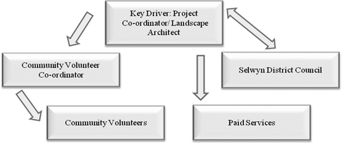
The main contributors to the project changed as the project moved into implementation phases. This was a deliberate move that was considered to be important for the management of the project. The initial key driver (with the vision) was a community member with a local understanding of the site. Once the project moved into implementation, this key driver was replaced by a paid, qualified and experienced Project coordinator/ Landscape architect. This move ensured that the key driver role would be retained on a professional basis to ensure the ongoing success of the project.
The sixth factor leading to the success of this project was the persistent support by the local community for the project's vision. This support was demonstrated from the initial presentation of the vision through to the present-day, whereby community members remain active supporters of the Park. This ‘hands on’ approach has been critical to the overall success of the Park. The Park's success by way of strong community involvement adds weight to the statement by Gooch (Citation2004, p. 195) that,
volunteer groups are potentially very influential. They can provide mediation between the government and individuals; opportunities for the integration of subgroups into the national society; and have the capacity to distribute power and initiate social change.
We also believe that projects such as this must have the support of ‘influential’ community members in order to sustain the process through to ultimate development. This was the case for the Prebbleton Nature Park. Several Prebbleton Community Board members, as well as local Lincoln University Staff, contributed to the ongoing development of the project and helped to maintain its momentum and direction.
Since implementation phases commenced, several community members have retained a strong interest in the Park, regularly undertaking the maintenance tasks required. This has enabled the native plants to establish and grow more rapidly than if this regular maintenance was not undertaken.
Finally, it is also vital to ensure that projects such as this are safeguarded in perpetuity. There is a very real threat to the park if its status is not secured through legal processes. Currently, the Park retains classification as a Gravel Reserve (Gravel Reserve 202), allowing for associated extraction and development as part of its defined purpose. Because of the restoration work and because the Pit has reached its extraction capacity according to the Council's records, the status of the site would be more appropriately assigned Reserve status under New Zealand legislation: the Local Government Act 2003 through the District Plan Zoning process and the Reserves Act 1977 through the Gazetting process.
Conclusion and recommendations
The overall aim of this research was to develop a process for converting a dis-used gravel pit into a public amenity. The success of the Prebbleton Nature Park and subsequent documentation of its successes and failures provided an ideal case study from which to develop the methodology.
In summary, we recommend that the key steps for restoring a dis-used gravel pit or other environmentally degraded site into a combined amenity and conservation area are as follows.
| 1. | develop a vision | ||||
| 2. | engage the local community | ||||
| 3. | engage the local authority | ||||
| 4. | prepare a concept plan | ||||
| 5. | design the amenity and conservation area | ||||
| 6. | implement the plan | ||||
Acknowledgements
Particular thanks go to Selwyn District Council and the Prebbleton community for their support of the project and provision of information, and to Lincoln University for assistance as the project developed. Thanks also for the tireless efforts of the Selwyn District Council, the Project coordinators and the volunteers of the community, who have given much of their time freely to the project and brought the Park through to the asset that it is today.
References
- Collier , KJ , Clarkson , BD , Aldridge , BMTA & Hicks , BJ 2008 , ‘ Can urban streams be restored? Linking vegetation restoration with urban storm water mitigation ’, in Proceedings of the New Zealand Waters & Wastes Association Stormwater 2008 Conference , Rotorua, 15-16 May 2008, CD-Rom, Water New Zealand, Wellington .
- Cozens , PM , Saville , G and Hillier , D . 2005 . Crime prevention through environmental design (CPTED): a review and modern bibliography . Property Management , 23 : 328 – 356 .
- Frey , M 2002 , ‘ Prebbleton Gravel Pit – concept development plan for the future of the pit ’, report produced for Selwyn District Council , Christchurch , New Zealand .
- Frey , M 2003 , ‘ Feasibility study of a template model for assessing gravel pits as passive ecological reserves ’, Masters thesis, Environment , Society and Design Division, Lincoln University , Canterbury, , New Zealand .
- Gooch , M . 2003 . A sense of place: ecological identity as a driver for catchment volunteering . Australian Journal on Volunteering , 8 ( 2 ) : 23 – 32 .
- Gooch , M . 2004 . Volunteering in catchment management groups: empowering the volunteer . Australian Geographer , 35 ( 2 ) : 193 – 208 .
- Gooch , M . 2005 . Voices of the volunteers: an exploration of the experiences of catchment volunteers in coastal Queensland, Australia . Local Environment , 10 ( 1 ) : 5 – 20 .
- Greater Wellington Regional Council (GWRC) , 2004 , Restoration planting: a guide to planning restoration planting projects in the Wellington region , GWRC , Wellington .
- Greater Wellington Regional Council (GWRC) , 2004 , Managing your bush block, a guide to looking after your indigenous forest remnants in the Wellington region , GWRC , Wellington .
- Hart , DD . 2002 . Roles for scientists in community-based ecological restoration . BioScience , 52 : 643
- Kelly , AH . 2006 . Securing urban amenity: does it coincide with biodiversity conservation at the local government level? . Australasian Journal of Environmental Management , 13 : 243 – 253 .
- Measham , TG & Barnett , GB , 2007 , Environmental volunteering: motivations, modes and outcomes , Socio-Economics and the Environment in Discussion (SEED), CSIRO Working Paper Series 2007–03 , CSIRO Sustainable Ecosystems , Canberra .
- Measham TG , Barnett GB. 2007 . Environmental volunteering: motivations, modes and outcomes . CSIRO Working Paper Series Number 2007–03.
- Milgrom , T . 2008 . Environmental aspects of rehabilitating abandoned quarries: Israel as a case study . Landscape and Urban Planning , 87 : 172 – 179 .
- Pearce , JL 1993 , Volunteers: the organisational behaviour of unpaid workers , Routledge , London .
- Rehounkova , K and Prach , K . 2007 . Spontaneous vegetation succession in gravel-sand pits: a potential for restoration . Restoration Ecology , 16 : 305 – 312 .
- Santoul , F , Figuerola , J and Green , AJ . 2004 . Importance of gravel pits for the conservation of waterbirds in the Garonne River floodplain (southwest France) . Biodiversity and Conservation , 13 : 1231 – 1243 .
- Selwyn District Council , 2008 , Community Services Activity Management Plan , Rolleston, Christchurch , New Zealand .
- Selwyn District Council 2009 , Selwyn Community Plan (LTCCP) 2009-2019 , Rolleston, Christchurch , New Zealand .
- Warburton , J , Marshall , S , Warburton , K and Gooch , M . 2005 . Information-related constraints on the effectiveness of environmental volunteers: a case study . Australian Journal on Volunteering , 10 ( 1 ) : 24 – 31 .
- Williams , K 2005 , Native plant communities of the Canterbury Plains , Department of Conservation, Christchurch , New Zealand .