
ABSTRACT
The coasts, islands and waters of the Great Barrier Reef have been home for First Nations peoples for thousands of years. Most of the islands and coral cays of the Great Barrier Reef World Heritage Area (GBRWHA) formed in the Holocene (last 11,700 years) following postglacial sea level rise. Continuous First Nations coastal occupation occurred in the GBRWHA from at least c.9000 years ago to the present with increasingly intensive coast and island use evident by the Mid-Holocene (c.4000–6000 years ago), with specialised maritime economies known historically and ethnographically emerging throughout the Late Holocene (past 4000 years). Archaeological research in the GBRWHA has focused on when islands were first used and/or seasonally or permanently occupied; how people travelled to islands; Melanesian and Asian connections; cultural responses to insularity and isolation; and the effects of sea-level and climate change. GBRWHA archaeological sites are unique archives of information on long-term inter-relationships between environment and culture that can inform current climate and sea level debates. Coastal and island sites are impacted by many processes that differentially alter or remove them from the archaeological record, necessitating complex approaches to understanding their formation, preservation, functions and management in partnership with contemporary First Nations communities.
Introduction
It is widely accepted that the Great Barrier Reef is the world’s biggest single structure made by living organisms (). Fewer people might be aware that First Nations people were present in Australia before, during, and after the modern Reef formed, arriving prior to 65 ka (Clarkson et al. Citation2017). First Nations people were present 30,000 years ago when reef growth first initiated on the shelf edge (; see Webster et al. Citation2018 for a discussion of the evolution of the Great Barrier Reef). Moreover, First Nations peoples actively engaged with the Great Barrier Reef across the subsequent millennia through to the modern evolution of the system, from 10,000 years ago (known as Reef 5 or the modern Holocene reef), and these cultural connections have continued through to the present day. Over millennia, First Nations peoples along the Queensland coast visited the Reef and created and interacted with culturally meaningful seascapes, including the 600 or so islands and 300 coral cays in the Great Barrier Reef World Heritage Area (GBRWHA), in diverse ways (). First Nations people lived through times when lands that were hills on what was part of the mainland became offshore islands through the process of postglacial sea-level rise. Indigenous histories document when people were able to walk to several groups of, what are now, islands. These include islands off Cairns, as well as Hinchinbrook and Palm, Albany and Jiigurru (Lizard) Islands (see Nunn et al. Citation2022; Nunn and Reid Citation2016 for details) ().
Figure 1. Australia, showing the location of Queensland and key places on the Great Barrier Reef mentioned in text. The dotted line shows the boundary of the Great Barrier Reef World Heritage Area.
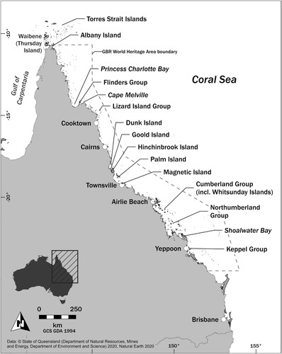
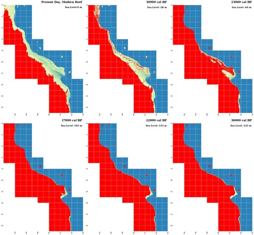
Figure 2. Queensland coastline shown at key time-slices associated with the evolution of the Great Barrier Reef over the past 30,000 years (after Webster et al. Citation2018, ). Red indicates extent of terrestrial coasts and islands during each of the key reef turn-off/death events, which includes Reef 1 (∼30 ka), Reef 2 (22 ka), Reef 3a (17 ka), Reef 3b (13 ka), and Reef 4 (10 ka). The modern, present day, Reef 5 is also shown. See Williams et al. (Citation2018, Table S1) where the chronology of sea-level rise is tabulated.
Saltwater People – people whose identity is intimately tied to the sea and whose Sea Countries include contemporary offshore islands – continue to see these places as retaining intimate
aspects of their traditional obligations and custodial identity: the sacred; the spiritual; the creation; the linguistic; the named; the inherited; the known; the past and lived present; the sustenance for all life and human livelihoods; the future of current and unborn generations to come. (Bock et al. Citation2022, 316; see also McNiven Citation2004; Sharp Citation2002)
Over some 50 years, archaeological scholarship has revealed the considerable antiquity of island and coastal use and marine subsistence specialisation and intimate ecological knowledge, providing complementary lines of evidence alongside First Nations histories and perspectives (e.g. Hale et al. Citation2022; Rowland, Wright, and Baker Citation2015; Van Issum Citation2016). The GBRWHA is currently home to 70 First Nations Traditional Owner groups who maintain strong cultural connections to the Reef and exploring options for co-management is essential to ongoing management. It is critical to be aware that the Western nature/culture dichotomy is a problematic in drawing links between First Nations knowledge and culture and biodiversity conservation. First Nations peoples regard this as a false dichotomy that fails to recognise the holistic nature of First Nations natural and cultural values encapsulated by the concept of Country as a sentient realm (Havemann et al. Citation2005; Kearney, Bradley, and Brady Citation2019; McNiven 2023a; Rose Citation1996).
Arriving
Coastlines, islands, and marine resources played a key role in the peopling of all continents, providing a wide range of opportunities for human adaptations and success in their long-term biological and cultural development (e.g. Will, Kandel, and Conrad Citation2019). While some groups resided inland and fished lakes and rivers, others on coasts and islands spent much of their time at sea living off marine resources (Bailey et al. Citation2015). Fishing in open seas was a major landmark in human history, requiring skills in watercraft construction and navigation technologies that ultimately opened up opportunities for connectivity and trade between some of the world’s most isolated islands (Will, Kandel, and Conrad Citation2019). Watercraft capable of open-ocean voyaging greater than 100 km offshore were required to get to Sahul (the combined continental landmass of Australia and New Guinea at times of lower sea level) and it is likely that people arrived by island hopping through Wallacea (Indonesia) and were therefore coastally adapted. Multiple colonisations from various entry points have been proposed (Bird et al. Citation2018; Kealy, Louys, and O’Connor Citation2018; Norman et al. Citation2018), along with purposeful and coordinated rather than random voyaging (Bird et al. Citation2019; Bradshaw et al. Citation2019) and even return voyaging (Norman et al. Citation2018, 238). When people arrived on the northwest shores of Sahul, they continued to use the ocean and its resources, while also moving further inland to other environments (Balme et al. Citation2019; Crabtree et al. Citation2021; Marsh et al. Citation2018; Veth et al. Citation2017; Citation2020).
Unfortunately, most of the material evidence for early coastal arrival is absent due to progressive submergence from Pleistocene and Holocene sea level change. Coastal erosion, cyclones, storm surges, and coastal progradation have also resulted in differential destruction and burial of coastal archaeological records (e.g. Rowland and Ulm Citation2012). In a substantive review of the Pleistocene and Holocene archaeological evidence, Ditchfield et al. (Citation2022) found no reason to assume that coastal landscapes were ever unproductive or unoccupied. New techniques for targeting submerged archaeological sites are now available and the potential for finding underwater sites has never been higher (Bailey et al. Citation2015; Benjamin et al. Citation2020; Citation2023; Veth et al. Citation2020). Evidence of coastal resource use is usually found in shell-matrix sites (usually referred to as middens; see Rick Citation2023 for a recent and comprehensive review of midden research world-wide) on mainland and island coastlines providing data for reconstructing peoples’ subsistence practices, their adaptations to coastal and island landscapes, and to changing environmental conditions over thousands of years. Islands are also of ceremonial importance (David et al. Citation2009; Fitzpatrick et al. Citation2018; Lambrides et al. Citation2020; McNiven et al. Citation2009).
Global warming after the Last Glacial Maximum (LGM) at ∼20 ka, saw sea level rise by some 130 m that flooded the continental shelf (Ishiwa et al. Citation2016). Australia and New Guinea were truncated by a shallow sea in the Early Holocene, and one-third of the continental landmass of Australia, or 2.12 million square km, was drowned (Williams et al. Citation2018). Holocene sea level peaked +1.0 to +1.5 m above current sea level between c.7500 and c.2000 cal BP, before dropping to approximately modern level (Dougherty et al. Citation2019; Lewis et al. Citation2013; Sloss et al. Citation2018). Further oscillations occurred around 4800 and 3000 cal BP associated with sea-level falls, which impacted the growth of coral reefs, reef islands, and intertidal (e.g. fish, molluscs) communities (Lewis et al. Citation2008). Fluctuating sea levels also influenced the extent of coral reefs and their use by First Nations groups across Australia. The earliest known, coastally oriented occupation in Sahul comes from the northwest of Australia, preserved in limestone caves on the Montebello and Barrow Islands at around 50,000 years ago (Manne and Veth Citation2015; Veth et al. Citation2017). Evidence for advanced maritime skills and for offshore fishing becomes more common following the Terminal Pleistocene/Early Holocene. Koolan Shelter 2 on Koolan Island on the west Kimberley coast, for example, has evidence for the use of coastal resources beginning at 10,500 BP (O’Connor Citation1999). There is a high potential for further early coastal sites to be found around the extensive Australian coastline.
Archaeology of the GBRWHA
The use of offshore islands in the GBRWHA and across Australia has been a significant focus of archaeological research (e.g. Barker Citation2004; Beaton Citation1985; Bowdler Citation1995; Jones Citation1976; Lambrides et al. Citation2020; McNiven et al. Citation2014; O’Connor Citation1992; Rowland Citation2008; Rowland, Wright, and Baker Citation2015; Ulm et al. Citation2019). Studies have focused on when islands were first visited and/or permanently occupied; the reasons people commenced using the islands; how people travelled to the islands; cultural responses to insularity, isolation, circumscription; and a range of other issues. Explanations have differed regionally depending on the distribution and type of islands, as well as distance from the continental coast and other factors. In general the study of island archaeological sites within the context of sea-level and climate change has provided considerable insights into the inter-relationship between environment and culture (Rowland, Wright, and Baker Citation2015, 154; Sim and Wallis Citation2008). While there are many island groups that have received no or limited archaeological research, there are a number of key island groups distributed across the length of the GBRWHA that have been the focus of dedicated research efforts for decades, including: Keppel Group, Northumberland Group, Cumberland Group, Jiigurru (Lizard Island Group), and Flinders Group (see ; e.g. Barker Citation2004; Border Citation1999; Lambrides et al. Citation2020; Lentfer et al. Citation2013; McNiven et al. Citation2014; Rowland Citation1999a; Wright, Faulkner, and Westaway Citation2023). In this paper we focus on the coast, islands and waters of the GBRWHA. First Nations groups along the Queensland coast were not restricted by such boundaries and movement occurred throughout the area and beyond.
Most existing islands of the GBRWHA were previously hilltops on the glacially exposed continental shelf, only becoming islands when the continental shelf was flooded during the marine transgression at the end of the Pleistocene and beginning of the Early Holocene (see ). It is likely that these elevated areas were visited or occupied prior to inundation. Other islands which formed more recently are associated with emerging coral reefs, riverine deltas, and changing sedimentation budgets (McNiven and Ulm Citation2015, 1).
Most islands in the GBRWHA and throughout Australia were not occupied until after 7000 cal BP and coastal and island archaeological sites older than 3000 cal BP are not common (Ulm Citation2011, 448). Sim and Wallis (Citation2008) propose that the majority of Australia’s offshore islands show a lacuna of human habitation for several thousand years after the marine transgression and before consequent insulation c.6700 years ago. With the imminent threat of inundation, they suggest people appear to have retreated to higher land, abandoning the peripheral exposed shelf areas; subsequent (re)colonisation of these relict shelf areas in their form as islands took place steadily from c.4200 BP, with increased intensity of occupation after 1300 BP. Archaeological investigations on the coast and islands of the GBRWHA generally indicate ephemeral use of coastal resources before the Mid-Holocene and significant changes in the Late Holocene towards increased rates of occupation. Explanations for this patterning however are diverse. Some have suggested this may be at least partly due to preservational bias, with the record skewed towards recent sites (e.g. Rowland and Ulm Citation2011). Others have focused on the importance of other environmental factors such as resource productivity and availability (e.g. Beaton Citation1985; Rowland Citation1999a) or the interplay of environmental and cultural factors (Haberle and David Citation2004; Rowland Citation1999b; Sim and Wallis Citation2008). Changes have also been linked to shifts in social structure, especially trends towards socioeconomic intensification, perhaps including population growth (e.g. Barker Citation2004; Lourandos Citation1997), and group fissioning (e.g. McNiven Citation1999; Memmott, Rosendahl, and Ulm Citation2016), or cultural responses to external contacts (McNiven Citation2017; Rowland Citation2018).
At Nara Inlet 1 on Hook Island, in the Whitsunday Islands (Cumberland Island Group), there is evidence of continuous coastal occupation from c.9000 cal BP to the present (Barker Citation2004). Barker (Citation2004) proposed that there was ephemeral use of coastal resources in the earliest levels at Nara Inlet 1, followed by more specialised marine economies focussing on turtle and dugong hunting associated with later more intensive occupation. Moving north, the South Island Headland Midden on South Island at Jiigurru (Lizard Island Group) was first occupied by 6500 cal BP, with periods of intense discard of reef resources (including shellfish and fish) interspersed with period of minimal occupation or abandonment (Ulm et al. Citationin press; Ulm and McNiven Citation2021). The location of Jiigurru more than 30 km off the mainland coast demonstrates people had the watercraft, navigation technology, and seafaring skills to access offshore areas by this time. Locally provenanced pottery was recovered from the South Island Headland Midden dating to around c.2500 years ago, indicating people were enmeshed in broader networks of trade and exchange with pottery-making communities across the Coral Sea. Nearby Yindayin Rockshelter on Stanley Island in the Flinders Group was occupied prior to 6000 cal BP and is said to indicate complex subsistence and occupation patterns, with periods of increased habitation intensity at the site interspersed with periods of stability and abandonment. Environmental and climate change are proposed to have the most significant effects on subsistence practices at Yindayin Rockshelter, while the potential for population-induced economic intensification was only identified within the last 200 years of occupation (Wright, Faulkner, and Westaway Citation2023). In central Queensland, Otterbourne Island in Shoalwater Bay was in use from 5200 cal BP (see ; McNiven et al. Citation2014). Evidence for the use of marine resources from the Early to Mid-Holocene on Whitsunday Island, Jiigurru, Stanley Island, and Otterbourne Island, as well as sites elsewhere located near palaeoshorelines (e.g. Torres Strait Islands – David et al. Citation2004; Wright Citation2011), provide support for the view of continuous use of coastal resources throughout the marine transgression, with people adapting to and following transgressive coastlines inland (see Rowland and Ulm Citation2012; Ulm Citation2011).
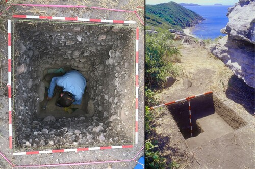
Figure 3. Examples of Great Barrier Reef archaeological sites: (L) South Island Headland Midden, Jiigurru, north Queensland, showing excavations in progress (Photograph: Ian J. McNiven). (R) Completed excavation at Otterbourne Island 4, Shoalwater Bay, central Queensland (Photograph: Ian J. McNiven).
Rowland (Citation1996; Citation1999a; Citation2008) identified a significant change in coastal and island use at c.3500 BP following excavations at Mazie Bay on North Keppel Island where a distinct change occurred in the stratigraphic and archaeological sequence. Discrete differences in fishing, molluscan foraging, and stone artefacts also occurred at this time. Subsequent palaeoenvironmental research in the Keppel Island Group, on relic barnacle species, supports the view of environmental change between 4200 and 3200 cal BP (Rowland, Wright, and Baker Citation2015). David et al. (Citation2004) and McNiven et al. (Citation2006) have also recognised a significant increase in activity on the Torres Strait Islands at c.3500 BP. Extensive coral/stone-walled tidal fishtraps (Kreij et al. Citation2018; McNiven and Lambrides 2023; Rowland and Ulm Citation2011), some of the largest engineered structures created by Aboriginal and Torres Strait Islander people, also appeared on the coast and islands of the GBRMPA, and more broadly along the Queensland coastline over the past 3000 years. These changes may result from a number of causes including environmental and socio-cultural factors which are discussed further below.
Nevertheless, the majority of known coastal and island archaeological sites date to the past millennium (Ulm Citation2011, 454) and are associated with structural changes in the archaeological record along with associated cultural change. After 1500 BP, changes in coastal settlement involve a localisation of resource use and a trend towards broad-based economies focused on resources clustered around the shoreline (Ulm Citation2006; Citation2011, 454). Recent analyses of molluscan and fish assemblages from excavations on Jiigurru (Lizard Island Group) showed an increased focus on these marine resources through time, but no discernible indication that anthropogenic and/or environmental factors altered the availability or population structure of these key preferred or targeted taxa (i.e. molluscs and fish) ( and ; Lambrides et al. Citation2020; Ulm et al. Citation2019). While the intensity of harvesting these marine resources increases throughout the Late Holocene, their availability appears to have remained constant, which is broadly in keeping with previous findings at other locales on the Great Barrier Reef. A recent synthesis of archaeological fish bone assemblages on the Queensland coast indicated geographic variability in the fish species captured and a broad increase in the range of species targeted through time (Lambrides, McNiven, and Ulm Citation2019). There was still local-level or site-specific variability in the species of fish targeted and this was likely underpinned by local ecological knowledge and differences in cultural preference for certain species across the region. Available archaeological evidence from the GBRWHA broadly indicates the long-term sustainable use (or continued availability) of marine resources, likely supported by flexible foraging strategies and engagement with diverse habitats and taxa. It has been hypothesised that these foraging approaches would have supported marine ecosystem resilience over thousands of years given these strategies were responsive to ecosystem dynamism and changes in resource availability (Lambrides et al. Citation2020).
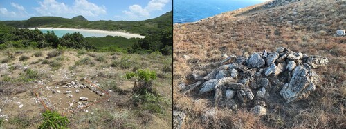
Figure 4. Examples of Great Barrier Reef archaeological sites: (L) Mangrove Beach Headland Midden, Jiigurru, north Queensland, showing excavations in progress (Photograph: Ian J. McNiven). (R) Constructed stone arrangement, Jiigurru, north Queensland (Photograph: Sean Ulm).
Some recent changes in the archaeological record have been linked to climatic changes. For example, a period of high-frequency El Niño Southern Oscillation (ENSO) events between c.2500 and 1000 BP, peaking at 1300 BP, is associated with more variable climate, including periods of aridity (Rowland Citation1999b; Shulmeister Citation1999) and coincides with widespread reductions in occupation across central and southeast Queensland (McNiven et al. Citation2014; Ulm Citation2006). Alterations in occupation patterns and broadened coastal resource use in the past 1500 years throughout Australia may have been, in part, a response to more variable climatic conditions, much like the reorganisation of settlement–subsistence systems thought to have taken place during the LGM (Williams et al. Citation2013). But as Rosendahl et al. (Citation2014) found when tested at the local level, more nuanced patterns of people–environment interaction emerge. While broad-scale narratives disclose significant patterns in the archaeological record, regional or local level patterns, as one might expect, are more complex.
The importance of islands
In a review of the archaeology of Australian islands, Bowdler (Citation1995, 956; Morrison, O’Leary, and McDonald Citation2023) concluded there was a ‘lack of obvious patterning’ in Indigenous island use apart from increased use by c.3000 years and more intensified use in the past 1000 years. Sim and Wallis (Citation2008) found little evidence for the use of small offshore islands during the ‘initial post-insulation (island) phase’ between approximately 6500 and 4500 BP. But these views are challenged by evidence of 9000 years of continuous occupation of the Whitsunday Islands (Barker Citation2004), dates of over 6000 BP from South Island Headland Midden at Jiigurru (Ulm et al. Citationin press), and Yindayin Rock Shelter on Stanley Island (Flinders Group; Wright, Faulkner, and Westaway Citation2023), and evidence of Mid-Holocene occupation at Badu 15 (Badu) and Dabangay (Mabuyag) in Torres Strait (David et al. Citation2004; Wright Citation2011). Sim and Wallis (Citation2008, 104) suggested that increased island use across northern Australia during the Late Holocene was ‘a direct human response to weather regimes becoming more conducive to coastal habitation and watercraft travel’. The presence of a midden on Otterbourne Island (Northumberland Group), dated at 5200 cal BP (McNiven et al. Citation2014), is in opposition to this view, and the issue of the development and types of watercraft available is likely more complex than Sim and Wallis allow (Rowland Citation1995).
Bowdler (Citation2010, 181) proposed that, rather than the present gentle tropical shore protected by the Great Barrier Reef, the Queensland Pleistocene coastline consisted of cliffed limestone ridges, rising 100 m or more above sea level, and that the coastal strip may therefore have been ‘cold, dry, sparsely vegetated and subject to widespread dust storms’. This important observation has yet to be investigated fully (but see Ditchfield et al. Citation2022). But it would seem that people were using coastal resources during the Late Pleistocene and Early Holocene and followed the coastline inland as sea level rose from the end of the LGM and some islands were formed at this time. For example, McNiven et al. (Citation2014) note that, among the Shoalwater Bay Islands, High Peak Island at 40 km from the mainland formed at around 11,500 years ago and its modern configuration was reached at 10,000 to 9000 years ago. Otterbourne Island, which is closer to the mainland, probably reached its modern configuration 8000 years ago. Other islands would not have formed until c.7000 years ago. The recording and excavation of sites on those islands have demonstrated that marine resources were being used prior to 5000 years ago.
Beaton’s (Citation1985) suggestion of a significant ‘time lag’ in the development of coastal economies following the end of sea-level rise is also no longer supported. It is unlikely that coastal resources would have taken long to establish following sea-level stabilisation, and it is unlikely, too, that these resources would have been overlooked, although resource abundance and availability may have been different than they are today (Rowland, Shaw, and Ulm Citation2023). Following sea-level stabilisation, cyclones, storm surges, and other erosive processes have destroyed many sites (Rowland and Ulm Citation2012; Williams et al. Citation2018). McNiven et al. (Citation2014) have proposed that for the Shoalwater Bay Islands the development of coral reefs and mangrove systems at c.3500 cal BP supported green turtle populations providing an incentive for the increased use of those islands. But regional patterns of marine biodiversity and food availability would have varied. For instance, the first occupation of Otterbourne Island occurred at 5200 cal BP and High Peak Island at 3250 cal BP (Northumberland Group). Also, coastal resources were being exploited at Mazie Bay prior to 4500 cal BP (Keppel Group; Rowland Citation1999a) and on Jiigurru before 6000 cal BP (Lizard Island Group; Lambrides et al. Citation2020; Ulm et al. Citationin press). Nevertheless, an increasing number of coastal island and mainland coastal sites do appear after c.3500 cal BP (Barker Citation2004; Beaton Citation1985; Border Citation1999; McNiven et al. Citation2014; Ulm Citation2000; Ulm and Reid Citation2000). Islands may also have been visited for other reasons that are not directly related to the abundance of food resources, such as for ceremonies, as could be implied, for example, by the large number of stone arrangements recorded on Jiigurru (Lizard Island) (Fitzpatrick et al. Citation2018) and the timing of these visits would be variable ().
Barker (Citation2004) noted the emergence of specialised marine economies at around 600 BP in the Whitsunday Islands. Rowland (Citation1996) thought it likely that the Keppel Islands were permanently occupied only from about c.700 BP. McNiven (Citation2006) argued that a significant increase in midden sites 600–800 years ago across Torres Strait signalled the emergence of ethnographically known social arrangements across the region. Research across Torres Strait has also revealed a distinctive series of cultural changes around 3500 BP (David et al. Citation2004; Linnenlucke et al. Citation2023; McNiven et al. Citation2006), but it was not until after 2500 BP that widespread occupation occurred in the form of numerous coastal middens (Barham Citation2000; Brady and Ash Citation2018; McNiven et al. Citation2006). Barham (Citation2000; see also Barham, Rowland, and Hitchcock Citation2004) associates changes around 2500 BP with the origins of the distinctive marine-oriented societies observed among contemporary Torres Strait Islander communities, while McNiven et al. (Citation2006) associate these changes with the influx of Papuan peoples and the introduction of pottery. Population dispersal in response to fluctuating environmental conditions has also been proposed to account in part for some increase in site numbers after 3500 BP (Rowland Citation1996, 195), with population increase also possible. Population increases and decreases are likely to have occurred throughout the Holocene, though fluctuations are difficult to demonstrate and changes are likely to have been variable through time and space.
Aspects of island biogeographical theory (MacArthur and Wilson Citation1967) have been used to understand the pattern of island use in the GBRWHA. For example, island size and distance from the mainland have been seen as critical factors in identifying which islands were visited seasonally or permanently, but it can be noted that none would have been permanently isolated due to offshore distance (Rowland Citation1996). To get to islands and maintain viable populations and economies requires watercraft, but direct archaeological evidence of watercraft is absent. Inferences must therefore be drawn from indirect evidence. Bowdler (Citation1995) suggested that watercraft were not made and used anywhere in Australia before the last 3000–2500 years. The presence of midden and other habitation sites on islands around Australia following their formation means that watercraft must have been used at least throughout the Holocene. Watercraft use along the GBRWHA coast of Queensland was complex. Single-piece bark canoes occurred along most of the Queensland coastline; three-piece sewn bark canoes were known around the Whitsunday Islands; double outriggers extended as far south as Cape Melville; and single outriggers were in use as far south as the Whitsunday Islands and possibly beyond (Rowland Citation1995; Citation2018). South Molle Island quarry was visited from 9000 cal BP and Border Island by 7000 cal BP (Whitsunday Islands; Barker Citation2004); Jiigurru at 33 km from the mainland by 6500 cal BP (Lizard Island Group; Ulm et al. Citationin press; Ulm and McNiven Citation2021); Stanley Island by 6000 cal BP (Flinders Group; Wright, Faulkner, and Westaway Citation2023); Otterbourne Island by 5200 cal BP (Northumberland Group; McNiven et al. Citation2014); and North Keppel Island by at least 4200 cal BP (Keppel Group; Rowland, Wright, and Baker Citation2015). Sites on the Percy Isles (Northumberland Group) demonstrate that 50 km trips from the mainland, or at least a 27 km island-hopping journey to the islands, were possible by at least 3000 cal BP (Border Citation1999; Rowland Citation1984).
No limiting distance for the extent of watercraft use can be identified in the GBRWHA and islands as small as 3 ha and 13 km from the mainland were visited, as were continental islands 50 km from the mainland (McNiven et al. Citation2014, 202; Rowland Citation1996; Rowland, Wright, and Baker Citation2015). On the Queensland coast, a few islands supported resident populations (Rowland Citation1996) but many may instead have been incorporated into broader coastal economies incorporating both mainland and island Sea Country. However, within the past 2000 years or less, it appears that some of the larger island groups, like Magnetic, Hinchinbrook, Goold, the Keppel, and the Whitsunday Islands, were permanently occupied (Rowland Citation1996; Rowland, Wright, and Baker Citation2015). Numerous islands across the Torres Strait were permanently occupied with resident communities within the past 1000 years (e.g. Barham Citation2000; Linnenlucke et al. Citation2023; McNiven Citation2015; Wright Citation2015).
It has been proposed (Jones Citation1976) that isolated populations whose numbers exceeded 500 could survive indefinitely, while those with fewer than 300 would become extinct. But many factors must be considered (Rowland Citation2008). The range and capabilities of watercraft available on the Queensland coast suggest that distance was not a factor that would have led to permanent isolation of any island population. Nevertheless, linguistic, biological, material cultural, and archaeological evidence from the Keppel Islands, in combination suggests a degree of isolation in a relatively small population over a period of at least 700 years (Rowland Citation2008). Population densities on GBRWHA offshore islands have been estimated to be up to 1 person per 25–125 ha (Rowland Citation1996, Table 11.4, 201). These densities are high in comparison with mainland Australia but can be explained in terms of the relationship between length of coastline and island area, not island area per se, where coasts and islands offer a coastal territorial advantage of three or four times compared with mainland areas.
European explorers on the Queensland coast noted that offshore islands were often more densely populated than many mainland areas and a degree of permanent or semi-permanent occupation is suggested by the number of huts observed on Dunk, Palm, Goold, Middle Percy Island, Jiigurru and the Keppel Islands (Rowland Citation2008), as well as massive fishtraps on Torres Strait Islands and Hinchinbrook Island (Rowland and Ulm Citation2011). Not all islands on the Queensland coast, however, supported permanent populations. Seasonal visits were made to some islands (Border Citation1999; Lambrides et al. Citation2020; McNiven et al. Citation2014; Rowland, Wright, and Baker Citation2015). The occupation of small islands presents particular challenges largely related to limited freshwater, terrestrial resources and susceptibility to natural disasters, but the challenges and risks can be offset or overcome through the use of maritime technologies, environmental knowledge, and exchange networks (McNiven Citation2015; Citation2016). A number of the islands off the Queensland coast have been viewed as seasonal resource bases for fishing, birding, or turtling, and as social retreats, although resource availability was central to the nature of their use (McNiven Citation2000). Island diversity was also significant in determining permanent or semi-permanent settlement. In some cases, there is evidence of more frequent movement within island groups than between the islands and adjacent mainlands (Border Citation1999; Lamb Citation2011; McNiven et al. Citation2014; Rowland Citation1996; Citation2008). Across Torres Strait, residential island populations and island diversity were enhanced by the introduction of plant domesticates, animal transfers and horticulture (e.g. Barham Citation2000; Harris Citation1977; McNiven Citation2008; McNiven and Hitchcock Citation2004).
Great Barrier Reef island archaeology: past, present, and future
Ongoing archaeological research and key knowledge gaps
There is a critical need to further define the nature of the Pleistocene coastlines and climate regimes of Australia in the context of potential use by people. As noted above, Bowdler (Citation2010, 181) suggested that the Pleistocene coastline of Queensland was ‘cold, dry, sparsely vegetated and subject to widespread dust storms’ making it unattractive for the development of coastal economies. The targeting of relict continental islands and underwater archaeological techniques are now available that would enable these issues to be investigated (Benjamin et al. Citation2020; Veth et al. Citation2019). Yet the coast of Queensland and some offshore islands provide compelling evidence for continuous, or near-continuous, occupation of island archipelagos over the past 7000 years. Elsewhere the potential of direct human proxies from palaeoecological archives to detect initial human impacts on islands is well known (e.g. Argiriadis et al. Citation2018; Burney, Burney, and MacPhee Citation1994; Prebble and Wilmshurst Citation2008) and need to be pursued in the GBRWHA.
There remains a need to identify when coastal resources were first widely used and to determine if there was a time lag in the development of coastal economies as initially proposed by Beaton (Citation1985). Further research on the timing of sea-level stabilisation and the formation of islands is critical. Determining how and when islands were used (i.e. seasonally or permanently) is central to assessing long-term modifications of landscapes and seascapes. Techniques such as sclerochronology (Twaddle et al. Citation2016) have yet to be employed to these questions in the GBRWHA. How well numbers of sites correlate with population also requires ongoing research, as does the nature and development of the Late Holocene specialised marine-based economies. Numerous mainland and island studies in northeast Australia have demonstrated a significant increase in numbers of coastal sites from the Mid-Holocene. As noted, explaining this increase is complex. Some studies have emphasised the primary role of social complexity, but population changes, internal social changes, changes in technology, external cultural contact, and the influences of insularity all need to be considered. Site preservation and sampling are also significant in explaining the spatial and temporal distribution of archaeological sites; sea level, climate change, and other environmental variables are also important. Significant cultural changes did centre around 3500 BP, along with changes in climate and sea levels. This apparent association can be better understood by developing multidisciplinary studies between archaeologists, environmental scientists, and Traditional Owner and custodian groups. Deterministic models, which focus on simplistic cause-and-effect arguments, whether they have an environmental or social focus, must be avoided (McNiven et al. Citation2014; Rowland, Wright, and Baker Citation2015; Ulm Citation2013).
Archaeologists have been comfortable in accepting the dramatic scale of climate and sea-level change and effects on people during the Pleistocene occupation of Sahul, but they have been less inclined to consider the extent and significance of less dramatic Holocene environmental changes. People in the past, as they do today, responded directly to environmental changes but also indirectly to changes in landscape and resource distribution that were initiated by the changes (Rowland Citation1999b, 11–12). People–environment interactions need to be investigated at the local level where more nuanced patterns emerge (see Rosendahl et al. Citation2014; Ulm Citation2013). Changes in northern Australia must also take account of external cultural contacts with New Guinea, and Macassan seafarers and others from island Southeast Asia (McNiven Citation2017; Oertle et al. Citation2014; Rowland Citation2018). The presence of Asian ceramics in Torres Strait dating to the sixteenth century and earthenware pottery of Melanesian form in Torres Strait and Jiigurru dating to 2000–3000 years ago indicates the international interaction of Queensland coastal communities prior to European invasion and a key ongoing research priority moving forwards (Grave and McNiven Citation2013; McNiven Citation2017; Citation2023b; McNiven et al. Citation2006; Rowland and Kerkhove Citation2022; Ulm et al. Citationin press; Ulm and McNiven Citation2021).
Ethnohistoric, ethnographic, and archaeological records provide evidence of movement and encounters of Aboriginal people and Torres Strait Islanders along the northeast coast of Queensland as far south as Lizard Island. These encounters are thought to be part of an expansive seascape that linked communities from the Gulf of Papua and northern Queensland, termed by McNiven et al. (Citation2004, 284; Citation2023b) the Coral Sea Cultural Interaction Sphere. There are reports of Torres Strait Islanders from Warraber and Poruma Islands (Central Islands) sailing some 600 km southeast to Lizard Island to source ‘clubstone’ for trade with Mer (Eastern Islands). The recovery of pottery sherds on Lizard Island provides supporting evidence for these broadscale interactions (McNiven Citation2022; Ulm et al. Citationin press) which may have extended further down the coast (Rowland Citation2018).
Focusing on a shell middens or campsites has proved useful in understanding contemporary issues in biological conservation and human–environment interactions. Archaeological data from middens are particularly useful for establishing the historical ecology of fisheries and ecological baselines for modern restoration. This is an important area of ongoing research world-wide (Rick Citation2023).
Ongoing threats and management implications
There are many factors affecting cultural and natural heritage values on the islands and waterways of the GBRWHA. Topping the list is global warming and rapidly heating waters. Rowland (Citation1996; Citation2010) has proposed that much Indigenous cultural heritage, especially that on the coast, continues to be under threat from climate change and sea-level rise, and has noted that a priority would be to ‘discuss with Aboriginal owners the potential impact of greenhouse changes on coastal sites’ (Rowland Citation1992, 31). This issue has been addressed by others (e.g. Carmichael et al. Citation2017; McIntyre-Tamwoy, Fuary, and Buhrich Citation2013; Rowland and Ulm Citation2012; Rowland, Ulm, and Roe Citation2014), but to date the research has been limited in scope. As Nursey-Bray et al. (Citation2019) argue, responding to climate change has been an ongoing activity for Indigenous groups for millennia. They suggest that support for Indigenous adaptation programs, and acknowledgement of old ways of seeing and doing, build agency and partnerships and collectively address current climate impacts on both Country and people. The continued establishment of First Nations-led programs across the GBRWHA will be fundamental to the ongoing health and resilience of the region into the future.
Other interests which have an impact on island archaeological sites are mining, commercial fishing, and particularly tourism and other recreational activities. Coastal zones are drawn as precise lines on maps but coastal sands and even cliffs, rocks and other features are not static in nature (Rowland and Ulm Citation2012). Tides, storms, wind, and erosion shape and transform coastlines. Transformation of coastlines is a natural process, whether dramatic or gradual. It can occur over minutes, hours, days or over thousands of years and longer. These otherwise natural processes are being triggered, exacerbated and accelerated by climate change (Ford and Kench Citation2015). Rowland (Citation1992, 31) for example suggests that an increase in sea level generated by climate change will erase significant parts of the archaeological record. A first step in assessing the effects of sea level rise and other impacts on archaeological sites involves desk-based modelling and vulnerability studies, modelling sea level rise through time and forecasting future threats to sites followed by GIS mapping, traditional archaeological survey, LiDAR, and other approaches (Rowland and Connolly Citation2002; Rowland, Ulm, and Roe Citation2014). While taphonomic and sampling factors are important, so too are social factors. Also, the antecedents of the complex systems recorded ethnohistorically and documented historically for the recent past remain poorly understood. Interpretations of marine resource use across Australia must be tempered by the large gaps in archaeological knowledge, reflecting the vast length of the coastline and the small number of archaeologists. Few coastal regions have been extensively surveyed, and basic site inventories and chronologies have not been established. Ongoing collaborative research projects must address some of these spatial data gaps and establish comprehensive records of these invaluable cultural places, as only then can monitoring, preservation, and mitigation against threats be properly undertaken.
We note there are numerous legislative requirements and guidelines available for managers in making decisions about the management of cultural and natural heritage on islands (e.g. provisions of the Aboriginal Heritage Act 2003Footnote1; and Commonwealth legislationFootnote2). Useful guidelines include Ask First produced by the Australian Heritage Commission,Footnote3 ICOMOS guidelinesFootnote4 and in particular specific guidelines relating to Indigenous use of the Great Barrier Reef.Footnote5 Intangible cultural heritage consists of traditional skills, beliefs, oral traditions, and stories. Intangible cultural heritage can be managed by developing collaborative partnerships with local First Nations communities throughout the GBRWHA. We do not have the space here to go into detail on the potential impacts on cultural heritage and management processes but argue strongly that all parties – First Nations groups, archaeologists, protected area agencies and managers, tourist operators, environmental scientists among others – must work together to protect and manage the complex cultural and natural heritage of the Great Barrier Reef, its waters, islands and mainland coast. First Nations knowledge and aspirations must be central to management of the Reef, waterways and islands. A most important development of modern archaeological practice is a growing emphasis on First Nations archaeology, community collaboration, and the coproduction of knowledge. This includes community co-designed research, active collaboration, engagement and outreach, breaking down barriers and silos, and expanding frameworks and understanding (Rick Citation2023).
Cultural heritage values were not included in the listing of the Great Barrier Reef World Heritage Area in 1981 but there is a general obligation under the World Heritage Convention to protect, conserve, present and transmit the cultural heritage of the Area. However, as the cultural heritage values of the Area are becoming increasingly known it might be appropriate to renominate the GBRWHA for its cultural heritage values. This would require an extensive period of consultation with the First Nations groups with interests and responsibilities in the Area. Islands and coastlines will continue to provide a rich source of research on climatic and ecological variability, isolation through distance, navigational skills, and population and social structure in small populations. Islands are also important models for future sustainability and as corollaries for the survival of humans generally (Fitzpatrick and Erlandson Citation2018). Yet, the deep First Nations history of the Great Barrier Reef, such as the use of its islands by Aboriginal people and Torres Strait Islanders across millennia are frequently not stressed in Reef management discussions. For example, Hutchings, Kingsford, and Hoegh-Guldberg (Citation2019) recently published the second edition of their volume The Great Barrier Reef, in which there are limited mentions of islands generally and ‘no significant assessment of Indigenous use of the reef and islands over at least the last 7000 years’ (Rowland Citation2020, 204). The capacity of people to alter marine and terrestrial environments through resource use, management, and enhancement (e.g. building infrastructure such as fishtraps and burning of vegetation) needs far greater attention in understanding the long-term history of use of the GBRWHA (e.g. McNiven, Manne, and Ross Citation2023; Proske and Haberle Citation2012; Rowe Citation2007). Fire has proven to be a particularly sensitive indicator of initial human activity in island ecosystems. Sedimentary charcoal accumulation rates have been found to increase by orders of magnitude immediately following human arrival (Burney, Burney, and MacPhee Citation1994; Hamley et al. Citation2022) and further research of this nature is critical to understanding first human use of the GBRWHA. Indeed, understanding long-term human alterations of lands and seas is fundamental to developing dynamic baselines for current and future management of the GBRWHA. Managing Australian environments as pristine wilderness is a ‘colonialist fantasy’ (Fletcher et al. Citation2021), which fails to recognise First Nations agency in the modification and engineering of these landscapes and seascapes over generations. Tropical coral reefs and associated islands, such as those within the GBRWHA, have been social-ecological systems for millennia, and ongoing management efforts must acknowledge the role of Aboriginal and Torres Strait Islander people in shaping these ecosystems to ensure effective management into the future. In referring to marine areas in general, an Aboriginal senior academic C.A. Marshall notes ‘the strongest and most basic desire is recognition of the Indigenous view of holistic land and sea management that includes people and culture’ (Marshall Citation2023, 127). We support and encourage this view in respect to management of islands within the GBRWHA.
Acknowledgements
We acknowledge the Aboriginal and Torres Strait Islander Traditional Owners and custodians of the coasts, islands, seas and skies of the Great Barrier Reef. Some of the research presented here was informed by decades of partnership research between the authors and First Nations communities across Queensland. We thank these communities for their pivotal role in the production of this archaeological scholarship. Many thanks to Matthew Harris for preparing the figures and to Damien O’Grady for generating the time-slices that are presented in . The Walmbaar Aboriginal Corporation gave permission to reproduce the photographs from Jiigurru (Lizard Island).
Disclosure statement
No potential conflict of interest was reported by the author(s).
Correction Statement
This article has been republished with minor changes. These changes do not impact the academic content of the article.
Additional information
Funding
Notes
2 https://www.dcceew.gov.au/parks-heritage/heritage/publications/atsihp-act-guide-and-application-form.
5 Traditional use of the Marine Park | gbrmpa (https://www2.gbrmpa.gov.au/learn/traditional-owners/traditional-use-marine-park).
References
- Argiriadis, E., D. Battistel, D. B. McWethy, M. Vecchiato, T. Kirchgeorg, N. M. Kehrwald, C. Whitlock, J. M. Wilmshurst, and C. Barbante. 2018. “Lake Sediment Fecal and Biomass Burning Biomarkers Provide Direct Evidence for Prehistoric Human-Lit Fires in New Zealand.” Scientific Reports 8 (1): 12113. https://doi.org/10.1038/s41598-018-30606-3.
- Bailey, G. N., M. H. Devès, R. H. Inglis, M. G. Meredith-Williams, G. Momber, D. Sakwllariou, and A. M. Alsharekh. 2015. “Blue Arabia: Palaeolithic and Underwater Survey in SW Saudi Arabia and the Role of Coasts in Pleistocene Dispersals.” Quaternary International 38:42–57. https://doi.org/10.1016/j.quaint.2015.01.002.
- Balme, J., S. O’Connor, T. Maloney, D. Vannieuwenhuyse, K. Aplin, and I. E. Dilkes-Hall. 2019. “Long-Term Occupation on the Edge of the Desert: Riwi Cave in the Southern Kimberley, Western Australia.” Archaeology in Oceania 54 (1): 35–52. https://doi.org/10.1002/arco.5166.
- Barham, A. J. 2000. “Late Holocene Maritime Societies in the Torres Strait Islands, Northern Australia: Cultural Arrival or Cultural Emergence?” In East of Wallace’s Line: Studies of Past and Present Maritime Cultures of the Indo–Pacific Region. Modern Quaternary Research in South–East Asia Series No. 16, edited by S. O’Connor and P. Veth, 223–314. Rotterdam: AA Balkema Press. http://hdl.handle.net/1885/91320.
- Barham, A. J., M. J. Rowland, and G. Hitchcock. 2004. “Torres Strait Bepotaim: An Overview of Archaeological and Ethnoarchaeological Investigations and Research.” Memoirs of the Queensland Museum, Cultural Heritage Series 3 (1): 1–72.
- Barker, B. 2004. The Sea People: Late Holocene Maritime Specialisation in the Whitsunday Islands, Central Queensland. Canberra: Pandanus Books.
- Beaton, J. M. 1985. “Evidence for a Coastal Occupation Time-lag at Princess Charlotte Bay (North Queensland) and Implications for Coastal Colonisation and Population Growth Theories for Aboriginal Australia.” Archaeology in Oceania 20 (1): 1–20. https://doi.org/10.1002/j.1834-4453.1985.tb00096.x.
- Benjamin, J., M. O’Leary, J. McCarthy, W. Reynen, C. Wiseman, J. Leach, S. Bobeldyk, et al. 2023. “Stone Artefacts on the Seabed at a Submerged Freshwater Spring Confirm a Drowned Cultural Landscape in Murujuga, Western Australia.” Quaternary Science Reviews 313:108190. https://doi.org/10.1016/j.quascirev.2023.108190.
- Benjamin, J., M. O’Leary, J. McDonald, C. Wiseman, J. McCarthy, E. Beckett, P. Morrison, et al. 2020. “Aboriginal Artefacts on the Continental Shelf Reveal Ancient Drowned Cultural Landscapes in Northwest Australia.” PLoS One 15 (7): e0233912. https://doi.org/10.1371/journal.pone.0233912.
- Bird, M. I., R. J. Beaman, S. A. Condie, A. Cooper, S. Ulm, and P. Veth. 2018. “Palaeogeography and Voyage modelling Indicates Early Human Colonization of Australia was Likely from Timor-Roti.” Quaternary Science Reviews 191:431–439. https://doi.org/10.1016/j.quascirev.2018.04.027.
- Bird, M. I., S. A. Condie, S. O’Connor, D. O’Grady, C. Reepmeyer, S. Ulm, and C. J. A. Bradshaw. 2019. “Early Human Settlement of Sahul was not an Accident.” Scientific Reports 9:8220. https://doi.org/10.1038/s41598-019-42946-9.
- Bock, E., L. Hudson, J. Isaac, T. Vernes, B. Muir, T. Whap, M. Dulfer-Hyams, M. Mclean, and D. Fell. 2022. “Safeguarding Our Sacred Islands: Traditional Owner-Led Sea Country Governance, Planning and Management in Australia.” Pacific Conservation Biology 28 (4): 315–329. https://doi.org/10.1071/PC21013.
- Border, A. 1999. “Aboriginal Settlement of Offshore Islands in the Southern Great Barrier Reef Province, Central Queensland.” In Australian Coastal Archaeology, edited by J. Hall and I. J. McNiven, 129–139. Canberra: ANH Publication, Department of Archaeology and Natural History, Research School of Pacific and Asian Studies, The Australian National University.
- Bowdler, S. 1995. “Offshore Islands and Maritime Explorations in Australian Prehistory.” Antiquity 69 (266): 945–958. https://doi.org/10.1017/S0003598X0008248X.
- Bowdler, S. 2010. “The Empty Coast: Conditions for Human Occupation in Southeast Australia During the Late Pleistocene.” In Altered Ecologies: Fire, Climate and Human Influence on Terrestrial Landscapes, edited by S. G. Harbele, J. Stevenson, and M. Prebble, 177–185. Canberra: ANU E Press.
- Bradshaw, C. J. A., S. Ulm, A. N. Williams, M. I. Bird, R. G. Roberts, Z. Jacobs, and F. Saltré. 2019. “Minimum Founding Populations for the First Peopling of Sahul." Nature Ecology and Evolution 3:1057–1063. https://doi.org/10.1038/s41559-019-0902-6.
- Brady, L. M., and J. Ash. 2018. “New Radiocarbon Dates from Kirriri 4: Extending the 2,500 BP Signature for the Onset of the Torres Strait Cultural Complex to South Western Torres Strait, Northeast Queensland.” Australian Archaeology 84 (1): 1–7. https://doi.org/10.1080/03122417.2018.1458271.
- Burney, D. A., L. P. Burney, and R. D. E. MacPhee. 1994. “Holocene Charcoal Stratigraphy from Laguna Tortuguero, Puerto Rico, and the Timing of Human Arrival on the Island.” Journal of Archaeological Science 21 (2): 273–228. https://doi.org/10.1006/jasc.1994.1027.
- Carmichael, B., G. Wilson, I. Namarnyilk, S. Nadji, J. Cahill, S. Brockwell, and D. Bird. 2017. “Australian Indigenous Rangers Managing the Impacts of Climate Change on Cultural Heritage Sites.” In Public Archaeology and Climate Change, edited by T. Dawson, C. Nimura, E. López-Romero, and M.-Y. Daire, 162–174. Oxford: Oxbow Books.
- Clarkson, C., Z. Jacobs, B. Marwick, R. Fullagar, L. Wallis, M. Smith, C. Pardoe, et al. 2017. “Human Occupation of Northern Australia by 65,000 Years ago.” Nature 547 (7663): 306–310. https://doi.org/10.1038/nature22968.
- Commonwealth of Australia. 2019. Aboriginal and Torres Strait Islander Heritage Strategy for the Great Barrier Reef Marine Park. Published by the Great Barrier Reef Marine Park Authority.
- Crabtree, S. A., D. A. White, C. J. A. Bradshaw, F. Saltré, A. N. Williams, R. J. Beaman, M. I. Bird, and S. Ulm. 2021. “Landscape Rules Predict Optimal Superhighways for the First Peopling of Sahul.” Nature Human Behaviour 5:1303–1313. https://doi.org/10.1038/s41562-021-01106-8.
- David, B., I. J. McNiven, J. Crouch, Mura Badulgal, R. Skelly, B. Barker, K. Courtney, and G. Hewitt. 2009. “Koey Ngurtai: The Emergence of a Ritual Domain in Western Torres Strait.” Archaeology in Oceania 44 (1): 1–17. https://doi.org/10.1002/j.1834-4453.2009.tb00040.x.
- David, B., I. J. McNiven, R. Mitchell, M. Orr, S. Haberle, L. Brady, and J. Crouch. 2004. “Badu 15 and the Papuan-Austronesian Settlement of Torres Strait.” Archaeology in Oceania 39 (2): 65–78. https://doi.org/10.1002/j.1834-4453.2004.tb00564.x.
- Ditchfield, K., S. Ulm, T. Manne, H. Farr, D. O’Grady, and P. Veth. 2022. “Framing Australian Pleistocene Coastal Occupation and Archaeology.” Quaternary Science Reviews 293:107706. https://doi.org/10.1016/j.quascirev.2022.107706.
- Dougherty, A. J., Z. A. Thomas, C. Fogwill, A. Hogg, J. Palmer, E. Rainsley, and C. Turney. 2019. “Redating the Earliest Evidence of the Mid-Holocene Relative Sea-Level Highstand in Australia and Implications for Global Sea-Level Rise.” PLoS One 14 (7): e0218430. https://doi.org/10.1371/journal.pone.0218430.
- Fitzpatrick, S. M., and J. M. Erlandson. 2018. “Island Archaeology, Model Systems, the Anthropocene, and How the Past Informs the Future.” Journal of Island and Coastal Archaeology 13 (2): 283–299. https://doi.org/10.1080/15564894.2018.1447051.
- Fitzpatrick, A., I. J. McNiven, J. Specht, and S. Ulm. 2018. “Stylistic Analysis of Stone Arrangements Supports Regional Cultural Interactions Along the Northern Great Barrier Reef, Queensland.” Australian Archaeology 84 (2): 129–144. https://doi.org/10.1080/03122417.2018.1507807.
- Fletcher, M.-S., R. Hamilton, W. Dressler, and L. Palmer. 2021. “Indigenous Knowledge and the Shackles of Wilderness.” Proceedings of the National Academy of Sciences 118 (40): e2022218118. https://doi.org/10.1073/pnas.2022218118.
- Ford, M. R., and P. S. Kench. 2015. “Multi-Decadal Shoreline Changes in Response to Sea Level Rise in the Marshall Islands.” Anthropocene 11: 14–24. https://doi.org/10.1016/j.ancene.2015.11.002
- Grave, P., and I. J. McNiven. 2013. “Geochemical Identification of Asian Stoneware Jars from Torres Strait, Northeast Australia.” Journal of Archaeological Science 40 (12): 4538–4551. https://doi.org/10.1016/j.jas.2013.06.021.
- Haberle, S. G., and B. David. 2004. “Climates of Change: Human Dimensions of Holocene Environmental Change in Low Latitudes of the PEPII Transect.” Quaternary International 118–119:165–179. https://doi.org/10.1016/S1040-6182(03)00136-8.
- Hale, L., K. Gerhardt, J. C. Day, and S. F. Heron. 2022. “A First Nations Approach to Addressing Climate Change—Assessing Interrelated Key Values to Identify and Address Adaptive Management for Country.” https://doi.org/10.5070/P538257518.
- Hamley, K. M., J. L. Gill, K. E. Krasinski, D. V. Groff, B. L. Hall, D. H. Sandweiss, J. R. Southon, P. Brickle, and T. V. Lowell. 2022. “Evidence of Prehistoric Human Activity in the Falkland Islands.” Science Advances 8 (17): eabo6765. https://doi.org/10.1126/sciadv.abo6765.
- Harris, D. R. 1977. “Subsistence Strategies Across Torres Strait.” In Sunda and Sahul: Prehistoric Studies in Southeast Asia, Melanesia and Australia, edited by J. Allen, J. Golson, and R. Jones, 421–463. London: Academic Press.
- Havemann, P., D. Thiriet, H. Marsh, and C. Jones. 2005. “Traditional Use of Marine Resources Agreements and Dugong Hunting in the Great Barrier Reef World Heritage Area.” Environmental and Planning Law Journal 22:258-280.
- Hutchings, P., M. Kingsford, and O. Hoegh-Guldberg, eds. 2019. The Great Barrier Reef: Biology, Environment and Management. 2nd ed. Melbourne: CSIRO Publishing. 465 pp., ISBN 978-0-367-17428, (also available as e-book).
- Ishiwa, T., Y. Yokoyama, Y. Miyairi, S. Obrochta, T. Sasaki, A. Kitamura, and H. Matsuzaki. 2016. “Reappraisal of Sea-Level Lowstand During the Last Glacial Maximum Observed in the Bonaparte Gulf Sediments Northwestern Australia.” Quaternary International 397:373–379. https://doi.org/10.1016/j.quaint.2015.03.032.
- Jarvis, D., R. Hill, R. Buissereth, C. Moran, L. D. Talbot, R. Bullio, C. Grant, et al. 2019. Monitoring the Indigenous Heritage Within the Reef 2050 Integrated Monitoring and Reporting Program: Final Report of the Indigenous Heritage Expert Group. Townsville: Great Barrier Reef Marine Park Authority.
- Jones, R. 1976. “Tasmanian Aquatic Machines and Off-Shore Islands.” In Problems in Economic and Social Archaeology, edited by G. G. de Sieveking, I. H. Longworth, and K. E. Wilson, 235–263. London: Duckworth.
- Kealy, S., J. Louys, and S. O’Connor. 2018. “Least-Cost Pathway Models Indicate Northern Human Dispersal from Sunda to Sahul.” Journal of Human Evolution 125:59–70. https://doi.org/10.1016/j.jhevol.2018.10.003.
- Kearney, A., J. Bradley, and L. M. Brady. 2019. “Kincentric Ecology, Species Maintenance and the Relational Power of Place in Northern Australia.” Oceania 89 (3): 316–335. https://doi.org/10.1002/ocea.5232.
- Kreij, A., J. Scriffignano, D. Rosendahl, T. Nagel, and S. Ulm. 2018. “Aboriginal Stonewalled Intertidal Fishtrap Morphology, Function and Chronology Investigated with High-Resolution Close-Range Unmanned Aerial Vehicle Photogrammetry.” Journal of Archaeological Science 96:148–161. https://doi.org/10.1016/j.jas.2018.05.012.
- Lamb, L. 2011. Rock of Ages: South Molle Island Quarry, Whitsunday Islands: Use and Distribution of Stone Through Space and Time. Oxford: Archaeopress.
- Lambrides, A. B. J., I. J. McNiven, S. J. Aird, K. A. Lowe, P. Moss, C. Rowe, C. Harris, et al. 2020. “Changing Use of Lizard Island Over the Past 4000 Years and Implications for Understanding Indigenous Offshore Island Use on the Great Barrier Reef.” Queensland Archaeological Research 23:43–109. https://doi.org/10.25120/qar.23.2020.3778.
- Lambrides, A. B., I. J. McNiven, and S. Ulm. 2019. “Meta-Analysis of Queensland’s Coastal Indigenous Fisheries: Examining the Archaeological Evidence for Geographic and Temporal Patterning.” Journal of Archaeological Science: Reports 28:102057. https://doi.org/10.1016/j.jasrep.2019.102057.
- Lentfer, C. J., M. W. Felgate, R. A. Mills, and J. Specht. 2013. “Human History and Palaeoenvironmental Change at Site 17, Freshwater Beach, Lizard Island, Northeast Queensland, Australia.” Queensland Archaeological Research 16:141–164. https://doi.org/10.25120/qar.16.2013.227.
- Lewis, S. E., C. R. Sloss, C. V. Murray-Wallace, C. D. Woodroffe, and S. G. Smithers. 2013. “Post-Glacial Sea-Level Changes Around the Australian Margin: A Review.” Quaternary Science Reviews 74:115–138. https://doi.org/10.1016/j.quascirev.2012.09.006.
- Lewis, S. E., R. A. J. Wüst, J. M. Webster, and G. A. Shields. 2008. “Mid-Late Holocene Sealevel Variability in Eastern Australia.” Terra Nova 20 (1): 74–81. https://doi.org/10.1111/j.1365-3121.2007.00789.x.
- Linnenlucke, L., M. Bird, F. Petchey, G. Alliston, I. McNiven, B. David, and S. Ulm. 2023. “Assessing the Reliability of a Small-Scale Legacy Radiocarbon Dataset Using Chronometric Transparency Approaches: Torres Strait Radiocarbon Database.” Journal of Open Archaeology Data 11 (2): 1–9. https://doi.org/10.5334/joad.95.
- Lourandos, H. 1997. Continent of Hunter-Gatherers: New Perspectives in Australian Prehistory. Cambridge: Cambridge University Press.
- MacArthur, R. H., and E. O. Wilson. 1967. The Theory of Island Biogeography. Princeton: Princeton University Press.
- Manne, T., and P. M. Veth. 2015. “Late Pleistocene and Early Holocene Exploitation of Estuarine Communities in Northwestern Australia.” Quaternary International 385:112–123. https://doi.org/10.1016/j.quaint.2014.12.049.
- Marsh, M., P. Hiscock, D. Williams, P. Hughes, and M. Sullivan. 2018. “Watura Jurnti: A 42000–45000-Year-Long Occupation Sequence from the North-Eastern Pilbara.” Archaeology in Oceania 53 (3): 137–149. https://doi.org/10.1002/arco.5152.
- Marshall, C. A. 2023. “The Importance of Aboriginal Marine Park Management Concepts for Australia.” In Islands of Hope. Indigenous Resource Management in a Changing Pacific, edited by P. D’Arcy and D. D. Da-Wei Kuan, 123–142. Canberra: Australian National University Press.
- McIntyre-Tamwoy, S., M. Fuary, and A. Buhrich. 2013. “Understanding Climate, Adapting to Change: Indigenous Cultural Values and Climate Change Impacts in North Queensland.” Local Environment 18 (1): 91–109. https://doi.org/10.1080/13549839.2012.716415.
- McNiven, I. J. 1999. “Fissioning and Regionalisation: The Social Dimensions of Changes in Aboriginal Use of the Great Sandy Region, Southeast Queensland.” In Australian Coastal Archaeology, edited by J. Hall and I. J. McNiven, 157–168. Canberra: Australian National University.
- McNiven, I. J. 2000. “Treats or Retreats: Aboriginal Island Use Along the Gippsland Coast, Southeastern Australia.” The Artefact 23:22–34.
- McNiven, I. J. 2004. “Saltwater People: Spiritscapes, Maritime Rituals and the Archaeology of Australian Indigenous Seascapes.” World Archaeology 35 (3): 329–349. https://doi.org/10.1080/0043824042000185757.
- McNiven, I. J. 2006. “Dauan 4 and the Emergence of Ethnographically-Known Social Arrangements Across Torres Strait 600–800 Years Ago.” Australian Archaeology 62 (1): 1–12. https://doi.org/10.1080/03122417.2006.11681825.
- McNiven, I. J. 2008. “Inclusions, Exclusions, Transitions: Torres Strait Islander Constructed Landscapes Over the Past 4000 Years.” The Holocene 18 (3): 449–462. https://doi.org/10.1177/0959683607087934.
- McNiven, I. J. 2015. “Precarious Islands: Kulkalgal Reef Island Settlement and High Mobility Across 700 km of Seascape, Central Torres Strait and Northern Great Barrier Reef.” Quaternary International 385:39–55. https://doi.org/10.1016/j.quaint.2014.09.015.
- McNiven, I. J. 2016. “Increase Rituals and Environmental Variability on Small Residential Islands of Torres Strait.” Journal of Island and Coastal Archaeology 11 (2): 195–210. https://doi.org/10.1080/15564894.2015.1115789.
- McNiven, I. J. 2017. “Edges of Worlds. Torres Strait Islander Peripheral Participation in Ancient Globalizations.” In The Routledge Handbook of Globalization and Archaeology, edited by T. Hodos, 319–334. New York: Routledge.
- McNiven, I. J. 2022. “Beyond Bridge and Barrier: Reconceptualising Torres Strait as a Co-Constructed Border Zone in Ethnographic Object Distributions Between Queensland and New Guinea.” Queensland Archaeological Research 25:25–46. https://doi.org/10.25120/qar.25.2022.3885.
- McNiven, I. J. 2023a. “Dugong and Turtle as Kin: Relational Ontologies and Archaeological Perspectives on Ritualised Hunting by Coastal Indigenous Australians.” In The Oxford Handbook of the Archaeology of Indigenous Australia and New Guinea, edited by I. J. McNiven and B. David. 993-1020 Oxford: Oxford University Press. https://doi.org/10.1093/oxfordhb/9780190095611.013.36.
- McNiven, I. J. 2023b. “Coral Sea Cultural Interaction Sphere.” In The Oxford Handbook of the Archaeology of Indigenous Australia and New Guinea, edited by I. J. McNiven and B. David, 591–616. Oxford: Oxford University Press. https://doi.org/10.1093/oxfordhb/9780190095611.013.28.
- McNiven, I. J., B. David, G. Kod, and J. Fitzpatrick. 2009. “The Great Kod of Pulu: Mutual Historical Emergence of Ceremonial Sites and Social Groups in Torres Strait, NE Australia.” Cambridge Archaeological Journal 19 (3): 291–317. https://doi.org/10.1017/S095977430900050X.
- McNiven, I. J., N. de Maria, M. Weisler, and T. Lewis. 2014. “Darumbal Voyaging: Intensifying Use of Central Queensland’s Shoalwater Bay Islands Over the Past 5000 Years.” Archaeology in Oceania 49 (1): 2–42. https://doi.org/10.1002/arco.5016.
- McNiven, I. J., W. R. Dickinson, B. David, M. Weisler, F. von Gnielinski, M. Carter, and U. Zoppi. 2006. “Mask Cave: Red–Slipped Pottery and the Australian–Papuan Settlement of Zenadh Kes (Torres Strait).” Archaeology in Oceania 41 (2): 49–81. https://doi.org/10.1002/j.1834-4453.2006.tb00610.x.
- Mcniven, I. J., F. Gnielinski, and M. C. Quinnell. 2004. “Torres Strait and the Origin of Large Stone Axes from Kiwai Island, Fly River Estuary (Papua New Guinea).” Memoirs of the Queensland Museum 3 (1): 271–289.
- McNiven, I. J., and G. Hitchcock. 2004. “Torres Strait Marine Subsistence Specialisation and Terrestrial Animal Translocation.” Memoirs of the Queensland Museum, Cultural Heritage Series 3 (1): 105–162.
- McNiven, I. J., and A. B. J. Lambrides. 2023. “Stone-walled Fish Traps of Australia and New Guinea as Expressions of Enhanced Sociality.” In The Oxford Handbook of the Archaeology of Indigenous Australia and New Guinea, edited by I. J. McNiven and B. David. 413-448 Oxford: Oxford University Press. https://doi.org/10.1093/oxfordhb/9780190095611.013.49.
- McNiven, I. J., T. Manne, and A. Ross. 2023. “Enhanced Ecologies and Ecosystem Engineering: Strategies Developed by Aboriginal Australians to Increase the Abundance of Animal Resources.” In The Oxford Handbook of the Archaeology of Indigenous Australia and New Guinea, edited by I. J. McNiven and B. David. 329-360 Oxford: Oxford University Press. https://doi.org/10.1093/oxfordhb/9780190095611.013.14.
- McNiven, I. J., and S. Ulm. 2015. “Multidisciplinary Approaches to Australian Island Pasts: Late Pleistocene to Historical Perspectives on Australian Island Use.” Quaternary International 385:1–6. https://doi.org/10.1016/j.quaint.2015.06.032.
- Memmott, P., E. D. Rosendahl, and S. Ulm. 2016. “Fission, Fusion and Syncretism: Linguistic and Environmental Changes Amongst the Tangkic People of the Southern Gulf of Carpentaria, Northern Australia.” In Land and Language in Cape York Peninsula and the Gulf Country, edited by J.-C. Verstraete and D. Hafner, 105–136. Philadelphia: John Benjamins. https://doi.org/10.1075/clu.18.06mem.
- Morrison, P., M. O’Leary, and J. McDonald. 2023. “The Evolution of Australian Island Geographies and the Emergence and Persistence of Indigenous Maritime Cultures.” Quaternary Science Reviews 308:108071. https://doi.org/10.1016/j.quascirev.2023.108071.
- Norman, K., J. Inglis, C. Clarkson, J. T. Faith, J. Shulmeister, and D. Harris. 2018. “An Early Colonisation Pathway into Northwest Australia 70–60,000 Years Ago.” Quaternary Science Reviews 180:229–239. https://doi.org/10.1016/j.quascirev.2017.11.023.
- Nunn, P. D., and N. J. Reid. 2016. “Aboriginal Memories of Inundation of the Australian Coast Dating from More Than 7000 Years Ago.” Australian Geographer 47 (1): 11–47. https://doi.org/10.1080/00049182.2015.1077539.
- Nunn, P. D., I. Ward, P. Stephan, A. McCallum, W. R. Gehrels, G. Carey, A. Clarke, et al. 2022. “Human Observations of Late Quaternary Coastal Change: Examples from Australia, Europe and the Pacific Islands.” Quaternary International 638–639:212–224. https://doi.org/10.1016/j.quaint.2022.06.016.
- Nursey-Bray, M., R. Palmer, T. F. Smith, and P. Rist. 2019. “Old Ways for New Days: Australian Indigenous Peoples and Climate Change.” Local Environment 24 (5): 473–486. https://doi.org/10.1080/13549839.2019.1590325.
- O’Connor, S. 1992. “The Timing and Nature of Prehistoric Island Use in Northern Australia.” Archaeology in Oceania 27 (2): 49–60. https://doi.org/10.1002/j.1834-4453.1992.tb00284.x.
- O’Connor, S. 1999. 30,000 Years of Aboriginal Occupation: Kimberley, North West Australia. Canberra: Department of Archaeology and Natural History and Centre for Archaeological Research, The Australian National University.
- Oertle, A., M. Leavesley, S. Ulm, G. Mate, and D. Rosendahl. 2014. “At the Margins: Archaeological Evidence for Macassan Activities in the South Wellesley Islands, Gulf of Carpentaria.” Australasian Historical Archaeology 32: 64–71.
- Prebble, M., and J. M. Wilmshurst. 2008. “Detecting the Initial Impact of Humans and Introduced Species on Island Environments in Remote Oceania Using Palaeoecology.” Biol Invasions 11:1529–1556. https://doi.org/10.1007/s10530-008-9405-0.
- Proske, U., and S. G. Haberle. 2012. “Island Ecosystem and Biodiversity Dynamics in Northeastern Australia During the Holocene: Unravelling Short-Term Impacts and Long-Term Drivers.” The Holocene 22 (10): 1097–1111. https://doi.org/10.1177/0959683612441840.
- Rick, T. C. 2023. “Shell Midden Archaeology: Current Trends and Future Directions.” Journal of Archaeological Research. https://doi.org/10.1007/s10814-023-09189-9.
- Rose, D. B. 1996. Nourishing Terrains: Australian Aboriginal Views of Landscape and Wilderness. Canberra: Australian Heritage Commission.
- Rosendahl, D., S. Ulm, H. Tomkins, L. Wallis, and P. Memmott. 2014. “Late Holocene Changes in Shellfishing Behaviours from the Gulf of Carpentaria, Northern Australia.” The Journal of Island and Coastal Archaeology 9 (2): 253–267. https://doi.org/10.1080/15564894.2014.880757.
- Rowe, C. 2007. “A Palynological Investigation of Holocene Vegetation Change in Torres Strait, Seasonal Tropics of Northern Australia.” Palaeogeography, Palaeoclimatology, Palaeoecology 251 (1): 83–103. https://doi.org/10.1016/j.palaeo.2007.02.019.
- Rowland, M. J. 1984. “A Long Way in a Bark Canoe: Aboriginal Occupation of the Percy Isles.” Australian Archaeology 18 (1): 17–31. https://doi.org/10.1080/03122417.1984.12092928.
- Rowland, M. J. 1992. “Climate Change, Sea-Level Rise and the Archaeological Record.” Australian Archaeology 34 (1): 29–33. https://doi.org/10.1080/03122417.1992.11681449.
- Rowland, M. J. 1995. “Indigenous Water-Craft Use in Australia. The ‘Big Picture’ and Small Experiments on the Queensland Coast.” Bulletin of the Australian Institute for Maritime Archaeology 19 (1): 5–18.
- Rowland, M. J. 1996. “Prehistoric Archaeology of the Great Barrier Reef Province: Retrospect and Prospect.” In Archaeology of Northern Australia: Regional Perspectives, edited by P. Veth and P. Hiscock, 191–211. St. Lucia: Anthropology Museum, University of Queensland.
- Rowland, M. J. 1999a. “The Keppel Islands – ‘a 3000 Year’ Event Revisited.” In Australian Coastal Archaeology, edited by J. Hall and I. J. McNiven, 141–155. Canberra: ANH Publications, Australian National University.
- Rowland, M. J. 1999b. “Holocene Environmental Variability: Have Its Impacts Been Underestimated in Australian Pre-History?” The Artefact 22:11–40.
- Rowland, M. J. 2008. “Colonization, Environment and Insularity: Prehistoric Island Use in the Great Barrier Reef Province, Queensland, Australia.” In Comparative Island Archaeologies, edited by J. Connolly and M. Campbell, 85–104. Oxford: British Archaeological Reports.
- Rowland, M. J. 2010. “Will the Sky Fall In? Global Warming – An Alternative View.” Antiquity 84 (326): 1163–1171. https://doi.org/10.1017/S0003598X00067156.
- Rowland, M. J. 2018. “65,000 Years of Isolation in Aboriginal Australia or Continuity and External Contacts? An Assessment of the Evidence with an Emphasis on the Queensland Coast.” Journal of the Anthropological Society of South Australia 42:211–240.
- Rowland, M. J. 2020. Book Review. Hutchings, P., M. Kingsford, and O. Hoegh-Guldberg, eds. The Great Barrier Reef: Biology, Environment and Management. 2nd ed. Melbourne: CSIRO Publishing, 2019, 465 pp., ISBN 978-0-367-17428, (also Available as E-Book). Queensland Review, 202–204. https://doi.org/10.1017/qre.2020.17.
- Rowland, M. J., and M. Connolly. 2002. “Towards GIS Mapping and Spatial Modelling of Archaeological Sites in the Southeast Queensland Bioregion.” Queensland Archaeological Research 13:39–62. https://doi.org/10.25120/qar.13.2002.67.
- Rowland, M. J., and R. C. Kerkhove. 2022. “Evidence of External Contact Between the Pacific Basin and the East Coast of Australia During the Holocene: A Review.” Queensland Archaeological Research 25:47–66. https://doi.org/10.25120/qar.25.2022.3889.
- Rowland, M. J., B. Shaw, and S. Ulm. 2023. “Maritime Coastal and Island Societies of Australia and New Guinea.” In The Oxford Handbook of the Archaeology of Indigenous Australia and New Guinea. I. J. McNiven and B. David. 773–802 Oxford: Oxford University Press https://doi.org/10.1093/oxfordhb/9780190095611.013.29.
- Rowland, M. J., and S. Ulm. 2011. “Indigenous Fishtraps and Weirs of Queensland.” Queensland Archaeological Research 14:1–58. https://doi.org/10.25120/qar.14.2011.219.
- Rowland, M. J., and S. Ulm. 2012. “Key Issues in the Conservation of the Australian Coastal Archaeological Record: Natural and Human Impacts.” Journal of Coastal Conservation 16 (2): 159–171. https://doi.org/10.1007/s11852-010-0112-5.
- Rowland, M. J., S. Ulm, and M. Roe. 2014. “Approaches to Monitoring and Managing Indigenous Australian Coastal Cultural Heritage Places.” Queensland Archaeological Research 17:37–48. https://doi.org/10.25120/qar.17.2014.231.
- Rowland, M. J., S. Wright, and R. Baker. 2015. “The Timing and Use of Offshore Islands in the Great Barrier Reef Marine Province, Queensland.” Quaternary International 385:154–165. https://doi.org/10.1016/j.quaint.2015.01.025.
- Sharp, N. 2002. Saltwater People. Crows Nest: Allen & Unwin.
- Shulmeister, J. 1999. “Australasian Evidence for Mid-Holocene Climatic Change Implies Precessional Control of Walker Circulation in the Pacific.” Quaternary International 57/58:81–91. https://doi.org/10.1016/S1040-6182(98)00052-4.
- Sim, R., and L. A. Wallis. 2008. “Northern Australian Offshore Island Use During the Holocene: The Archaeology of Vanderlin Island, Sir Edward Pellew Group, Gulf of Carpentaria.” Australian Archaeology 67 (1): 95–106. https://doi.org/10.1080/03122417.2008.11681882.
- Sloss, C. R., L. Nothdurft, Q. Hua, S. G. O’Connor, P. T. Moss, D. Rosendahl, and S. Ulm. 2018. “Holocene Sea-Level Change and Coastal Landscape Evolution in the Southern Gulf of Carpentaria, Australia.” The Holocene 28 (9): 1411–1430. https://doi.org/10.1177/0959683618777070.
- Twaddle, R. W., S. Ulm, J. Hinton, C. M. Wurster, and M. I. Bird. 2016. “Sclerochronological Analysis of Archaeological Mollusc Assemblages: Methods, Applications and Future Prospects.” Archaeological and Anthropological Sciences 8 (2): 359–379. https://doi.org/10.1007/s12520-015-0228-5.
- Ulm, S. 2000. “Evidence for Early Focussed Marine Resource Exploitation from an Open Coastal Site in Central Queensland.” Australian Archaeology 51 (1): 66–67. https://doi.org/10.1080/03122417.2000.11681684.
- Ulm, S. 2006. Coastal Themes: An Archaeology of the Southern Curtis Coast, Queensland. Canberra: ANU E Press.
- Ulm, S. 2011. “Coastal Foragers on Southern Shores: Marine Resource Use in Northeast Australia Since the Late Pleistocene.” In Trekking the Shore: Changing Coastlines and the Antiquity of Coastal Settlement, edited by N. F. Bicho, J. A. Haws, and L. G. Davis, 441–461. New York: Springer. https://doi.org/10.1007/978-1-4419-8219-3.
- Ulm, S. 2013. “‘Complexity’ and the Australian Continental Narrative: Themes in the Archaeology of Holocene Australia.” Quaternary International 285:182–192. https://doi.org/10.1016/j.quaint.2012.03.046.
- Ulm, S., and I. J. McNiven. 2021. “Excavating Jiigurru.” In Connections Across the Coral Sea: A Story of Movement, edited by B. Mitchell and R. Ridgway, 30–33. South Brisbane: Queensland Museum.
- Ulm, S., I. J. McNiven, S. J. Aird, and A. J. Lambrides. 2019. “Sustainable Harvesting of Conomurex luhuanus and Rochia nilotica by Indigenous Australians on the Great Barrier Reef Over the Past 2000 Years.” Journal of Archaeological Science: Reports 28:102017. https://doi.org/10.1016/j.jasrep.2019.102017.
- Ulm, S., I. J. McNiven, G. R. Summerhayes, P.-H. Wu, M. M. E. Bunbury, F. Petchey, Q. Hua, et al. in press. “Early Aboriginal Pottery Production and Offshore Island Occupation on Jiigurru (Lizard Island Group), Great Barrier Reef, Australia.” Quaternary Science Reviews. https://doi.org/10.1016/j.quascirev.2024.108624.
- Ulm, S., and J. Reid. 2000. “Index of Dates from Archaeological Sites in Queensland.” Queensland Archaeological Research 12:1–129. https://doi.org/10.25120/qar.12.2000.78.
- Van Issum, H. J. 2016. “Woppaburra: Past and Present.” Unpublished PhD thesis, Faculty of Education and Arts, Australian Catholic University, Brisbane.
- Veth, P., K. Ditchfield, M. Bateman, S. Ouzman, M. Benoit, A. P. Motta, and Balanggarra Aboriginal Corporation. 2019. “Minjiwarra: Archaeological Evidence of Human Occupation of Australia’s Northern Kimberley by 50,000 BP.” Australian Archaeology 85 (2): 115–125. https://doi.org/10.1080/03122417.2019.1650479.
- Veth, P., J. McDonald, I. Ward, M. O’Leary, E. Beckett, J. Benjamin, and G. Bailey. 2020. “A Strategy for Assessing Continuity in Terrestrial and Maritime Landscapes from Murujuga (Dampier Archipelago), North West Shelf, Australia.” The Journal of Island and Coastal Archaeology 15 (4): 477–503. https://doi.org/10.1080/15564894.2019.1572677.
- Veth, P., I. Ward, T. Manne, S. Ulm, K. Ditchfield, J. Dortch, and P. Kendrick. 2017. “Early Human Occupation of a Maritime Desert, Barrow Island, North-West Australia.” Quaternary Science Reviews 168:19–29. https://doi.org/10.1016/j.quascirev.2017.05.002.
- Walpole, L. C., and W. L. Hadwen. 2022. “Extreme Events, Loss, and Grief – an Evaluation of the Evolving Management of Climate Change Threats on the Great Barrier Reef.” Ecology and Society 27 (1): 37. https://doi.org/10.5751/ES-12964-270137.
- Webster, J. M., J. C. Braga, M. Humblet, D. C. Potts, Y. Iryu, Y. Yokoyama, K. Fujita, et al. 2018. “Response of the Great Barrier Reef to Sea-Level and Environmental Changes Over the Past 30,000 Years.” Nature Geoscience 11 (6): 426–432. https://doi.org/10.1038/s41561-018-0127-3.
- Will, M., A. W. Kandel, and N. J. Conrad. 2019. “Midden or Molehill: The Role of Coastal Adaptations in Human Evolution and Dispersal.” Journal of World Prehistory 32 (1): 33–72. https://doi.org/10.1007/s10963-018-09127-4.
- Williams, A. N., S. Ulm, A. R. Cook, M. C. Langley, and M. Collard. 2013. “Human Refugia in Australia During the Last Glacial Maximum and Terminal Pleistocene: A Geospatial Analysis of the 25-12ka Australian Archaeological Record.” Journal of Archaeological Science 40 (12): 4612–4625. https://doi.org/10.1016/j.jas.2013.06.015.
- Williams, A. N., S. Ulm, T. Sapienza, S. Lewis, and C. S. M. Turney. 2018. “Sea-Level Change and Demography During the Last Glacial Termination and Early Holocene Across the Australian Continent.” Quaternary Science Reviews 182:144–154. https://doi.org/10.1016/j.quascirev.2017.11.030.
- Wright, D. 2011. “Mid Holocene Maritime Economy in the Western Torres Strait.” Archaeology in Oceania 46 (1): 23–27. https://doi.org/10.1002/j.1834-4453.2011.tb00096.x.
- Wright, D. 2015. Community Emergence and Development on Mabuyag, Western Torres Strait. British Archaeological Reports International Series S2754. Oxford: Archaeopress.
- Wright, M., P. Faulkner, and M. Westaway. 2023. “Evaluating Mid- to Late Holocene Economic Intensification Through Analysis of a Mollusk Assemblage on the Tropical North Australian Coast.” In Human Behavioral Ecology and Coastal Environments, edited by H. B. Thakar and C. F. Fernandez, 199–228. Gainesville, FL: University Press of Florida.