
 ?Mathematical formulae have been encoded as MathML and are displayed in this HTML version using MathJax in order to improve their display. Uncheck the box to turn MathJax off. This feature requires Javascript. Click on a formula to zoom.
ABSTRACT
We present the Geocentric Datum of Australia 2020, the latest update to the Australian national datum. This update results in a more accurate and precise datum that is better suited to modern positioning needs. Improvements include the removal of the distortions present in the previous national datum, a reduction in the offset to the current International Terrestrial Reference Frame, and the provision of rigorous uncertainties. We also describe the input data and the methods used to perform a rigorous, all-station, continental-scale least-squares adjustment of the national geodetic network, consisting of more than 2.4 million measurements to more than 330,000 survey control marks.
Introduction
To measure position accurately, the Earth’s surface cannot be assumed to be static. The Australian continent is constantly moving and deforming due to geophysical processes such as plate tectonic motion (Dawson and Woods Citation2010, Altamimi et al. Citation2016), hydrological cycles (Brown and Tregoning Citation2010), earthquakes (Tregoning et al. Citation2013, Riddell et al. Citation2020b), ocean loading (Riddell et al. Citation2020a), and post glacial rebound (Mitrovica et al. Citation2001, Thomas et al. Citation2011). A highly accurate datum is therefore required to measure these geophysical processes and their effects on coordinate estimates. It is also required for the societal applications of positioning, to better support the improved accuracy and precision of positioning technology and the applications that enables.
To address these requirements, the Australian Geospatial Reference System (AGRS) provides a collection of datums, infrastructure, models, and standards to enable accurate four-dimensional positioning and the alignment of spatial data (ICSM Citation2022). It was recently upgraded to support the Australian Government’s investment in the Positioning Australia program – a national system for open, reliable, and high-accuracy positioning across Australia’s land and maritime jurisdiction. The AGRS upgrade included the adoption of a new static datum – the Geocentric Datum of Australia 2020 (GDA2020) and a time-dependent reference frame – the Australian Terrestrial Reference Frame 2014 (ATRF2014).
The improved static datum, GDA2020, is a plate-fixed datum whose coordinates are constant with time. Therefore, GDA2020, fixed to an epoch of 1 January 2020, continues to grow out of alignment with the International Terrestrial Reference Frame 2014 (ITRF2014; Altamimi et al. Citation2016), with the offset increasing at ~7 cm/yr due to horizontal tectonic plate motion. This offset provides the rationale for the establishment of a second frame, ATRF2014. This time-dependent reference frame remains aligned with ITRF2014, the international standard for positioning and the system in which Global Navigation Satellite Systems (GNSS) are referenced.
Since the development of GDA94 (ICSM Citation2014), there have been numerous advances that have increased the accuracy of positioning, including: the addition of more GNSS constellations (e.g., Galileo and BeiDou), corrections streams provided through internet or satellite communications, significant investment in positioning infrastructure such as the AuScope Continuously Operating Reference Station (CORS) network, and improvements in GNSS hardware and analysis including absolute antenna modelling (Riddell et al. Citation2015). Furthermore, there have been improvements to ITRF, which have resulted in better alignment of the terrestrial reference frame to the present-day shape and orientation of the Earth. For example, between ITRF92 (the basis for GDA94) (Boucher et al. Citation1993) and ITRF2014 (the basis for GDA2020) (Altamimi et al. Citation2016), the scale factor had been refined, which resulted in a consistent reduction in ellipsoidal heights across Australia, with GDA2020 heights being ~9 cm less than GDA94 heights.
A crucial difference between GDA2020 and GDA94 is that GDA2020 was implemented via a single rigorous continental-scale adjustment – a first for an Australian datum. This allows the rigorous realisation of the frame down to the state and territory networks. When GDA94 was developed computing power was not sufficient to adjust the entire national geodetic network simultaneously. To overcome this, the hierarchical structure shown in was adopted with sub-networks being assigned to levels in the hierarchy based on their quality.
Figure 1. GDA94 was adjusted in an hierarchical fashion, with lower-level networks being adjusted while holding the higher-level networks fixed. This led to distortions in parts of the network. GDA2020, however, was implemented via a single rigorous continental-scale adjustment – a first for an Australian datum. This allows the rigorous realisation of the frame down to the state and territory networks.
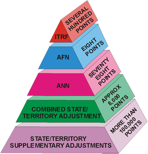
These sub-networks were adjusted sequentially from the top down, with coordinates produced from higher-level sub-network adjustments being held fixed in lower adjustments and their uncertainties ignored (Fraser et al. Citation2023). For example, to compute the coordinates of the Australian National Network (ANN), the Australian Fiducial Network (AFN) sites were held fixed by assigning them zero positional uncertainty.
This resulted in two issues that make GDA94 less suitable for high-accuracy positioning (Donnelly et al. Citation2014, Haasdyk et al. Citation2014). The first was the lack of rigour in propagating uncertainties between levels, which caused these uncertainties to be underestimated. The second issue was, by assuming the coordinates of higher levels were exact, distortions were introduced into the network (Haasdyk et al. Citation2014). For GDA2020, the entire national geodetic network is adjusted in a single least-squares adjustment, which permits the rigorous propagation of uncertainties and thereby eliminates any distortion in the station coordinates.
The ability to perform a single, rigorous national adjustment is provided by DynAdjust, a least-squares adjustment application (Fraser et al. Citation2022). DynAdjust achieves this by automatically segmenting the national geodetic network and adjusting each segment sequentially using a rigorous, yet highly efficient technique.
Section 2 gives an overview of the national adjustment process. Section 3 describes the data sets used in the adjustment, including the Asia-Pacific Reference Frame (APREF) network, and details of the processing required by the National GNSS Campaign Archive (NGCA). Section 4 introduces DynAdjust and discusses how data from state and territories are included in the national adjustment. Finally, we describe how all the data are brought together in the national adjustment to estimate the station coordinates and uncertainties.
All uncertainties are given at the 95% confidence level, unless otherwise stated.
The GDA2020 update process
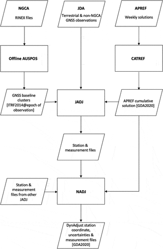
The GDA2020 coordinate set is produced by a single, rigorous least-squares adjustment of the entire Australian geodetic network, which eliminates any distortion in the network and provides rigorous uncertainties. The GDA2020 update process is run monthly to update this coordinate set. The process consists of three steps: 1) processing the NGCA; 2) performing the jurisdictional adjustments (JADJ); and 3) performing the national adjustment (NADJ) as shown in . The benefits of updating monthly include, using the latest version of the APREF cumulative solution to better constrain the NADJ, allowing new stations to be introduced into the network and poor measurements to removed. The number of CORS in the APREF network increases continually, as those that would like their positions legally determined, via the Regulation 13 process, are required to submit their data for inclusion in APREF. This allows their stability to be monitored.
Figure 2. The GDA2020 update process. Each jurisdiction performs a jurisdictional adjustment that uses the latest APREF solution to constrain their combined NGCA and JDA networks. These jurisdictional adjustments are then combined into a single national adjustment to produce the GDA2020 coordinate set.
Data
The national geodetic network consists of three data sets: the APREF cumulative solution; the NGCA, a national archive of high-quality GNSS measurements; and the Jurisdictional Data Archive (JDA), consisting of any other data that a jurisdiction wants included in the NADJ.
Asia-Pacific reference frame
The Asia-Pacific Reference Frame network (APREF; Hu et al. Citation2019) is a densification of ITRF realisations in the Asia-Pacific region. It is used to constrain the NADJ. In GPS week 2156 (week ending 8 May 2021), there were 674 CORS in the APREF cumulative solution and a discontinuity was detected in the time series of 104 of these CORS. These discontinuities are detected during routine analysis performed by GA and are added to the list of those detected by the International GNSS Service (IGS).
GA computes weekly solutions for all APREF stations, which are combined into a cumulative solution using the Combination and Analysis of Terrestrial REference Frames (CATREF) software (Altamimi et al. Citation2006) as a minimally constrained solution aligned to IGb14. The cumulative solution provides positions and velocities for all stations in the APREF network, in [email protected], and is the solution used in the NADJ. For stations with discontinuities, a position and velocity are calculated for each segment of its time series.
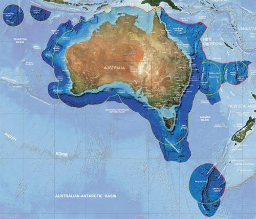
Stations outside the extent of GDA2020 (see ) are removed from the APREF solution, reducing the number of stations to 500. Not all these stations are operational.
Figure 3. The area shown in dark blue is the extent of GDA2020 (ICSM Citation2021). The colours of the lines represent different types of jurisdictional boundaries. For more information, please refer to http://www.ga.gov.au/metadata- gateway/metadata/record/gcat_70362 today. The solution is transformed to [email protected] using the Australian Plate-Motion Model (ICSM Citation2021).
To ensure the computed uncertainties reflect a more realistic indicator of station coordinate quality, additional Type B measurement uncertainties are added (ICSM Citation2020a). These uncertainties cater for known variations such as building movement, ground instability and seasonal variations. For the 109 Recognized-Value Standard (RVS) stations, the Type B uncertainties are 3 mm, 3 mm, and 6 mm (east, north, and up). For all other stations, the Type B measurement uncertainties are 6 mm, 6 mm, and 12 mm (east, north, and up). It is difficult to accurately determine the velocities of stations with short time series and their propagated positions can be unstable. Therefore, unstable stations and stations with less than 2 years of data are removed from the APREF solution that constrains the NADJ and are included as a GNSS baselines.
Australian plate-motion model
The Australia continent is relatively free from deformation with the cumulative horizontal deformation from great earthquakes found to be <0.2 mm/yr (Tregoning et al. Citation2013). The motion of the continent can be modelled by a clockwise rotation about a Euler pole. The instantaneous velocity of this rotation results in, what appears to be, a linear motion of ~7 cm/yr in a north-northeast direction, with locations further from the pole moving faster than those closer.
The Australian Plate-Motion Model (PMM) was created through analysis of the APREF solution, which showed that the horizontal stability of APREF stations is 1 mm/yr or less. However, to achieve a more statistically reliable PMM, a subset of 109 APREF stations that were stable at the <0.3 mm/yr level were used. These stations formed the Recognized-Value Standard Determination that was used to define GDA2020.
To calculate the PMM, the cumulative solution positions of the 109 RVS station were fit to a 14-parameter similarity transformation in which all parameters except the three rotation rates of change were set to zero. These rotation rates of change in arcseconds/yr are shown in .
Table 1. The Australian PMM rotation rates and their 1σ uncertainties (in arcseconds/yr).
The Australian PMM can be used to transform coordinates between ITRF2014 at any epoch and GDA2020, to transform coordinates between GDA2020 and ATRF2014 at any epoch, and to propagate ATRF2104 coordinates to different epochs.
Recognized-value standard determination
The coordinates of the 109 RVS stations are used to define GDA2020 via the National Measurement (Recognized-Value Standard of Measurement of Position) Determination of 2017 (the RVS Determination; https://www.legislation.gov.au/Details/F2017L01352).
Unlike previous determinations, this new RVS Determination also contains velocities, the uncertainties of both quantities, and a formula to linearly propagate coordinates to different epochs using the velocities provided. This enables the GDA2020 coordinates in the Determination to be propagated to ATRF2014 and expressed at any epoch within 15 years of the epoch of GDA2020 (01.01.2020) in a legally traceable manner.
National GNSS campaign archive
The NGCA is a national archive of high-quality GNSS observations supplied by each of the Australian jurisdictions. Incorporation of these observations allows GDA2020 coordinates and uncertainties to be accurately propagated throughout the national geodetic network and ensures a high level of consistency with GNSS positioning.
To be included in the NGCA, the observations must be made after 1 June 1994, and they must contain between 6 and 48 hours of observations sampled at 30 second epochs. Data from before 1 June 1994 cannot be processed because there are no International GNSS Service (IGS) products available before that date. GNSS observations that do not satisfy the above criteria are included in the NADJ via a JDA.
The processing of the NGCA RINEX files is carried out using the AUSPOS GNSS Processing Service (version 2.4) hosted by GA, which uses Bernese GNSS Software v5.2 (Dach et al. Citation2015). This service uses products from the IGS (Johnston et al. Citation2017) to compute precise coordinates in ITRF2014. It requires dual frequency GPS phase data collected with a known antenna type. More details are given in Appendix A.
For the APREF solution to correctly constrain the NADJ, all other measurements should be relative. Therefore, the SINEX files produced during the NGCA processing are converted to GNSS baselines retaining all the covariance information (GNSS baseline clusters).
Type B uncertainties are determined as per the Guideline for the Adjustment and Evaluation of Survey Control – Special Publication 1 (ICSM Citation2020a). For each GNSS baseline cluster, a minimally-constrained adjustment is performed and the resulting variance factor () is used to scale the estimated measurement uncertainties. Only stations in the APREF solution SINEX file are used for scaling the NGCA, that is, stations with time series longer than two years. The net result from the processing of the NGCA is a collection of high-fidelity GNSS baseline clusters with rigorous uncertainties traceable to GDA2020.
Jurisdictional data archives
All other data for the NADJ are contained in the Jurisdictional Data Archives (JDA). Mostly these contain terrestrial measurements, but they may also contain GNSS measurements that are not suitable for inclusion in the NGCA. All GNSS observations are included as baselines rather than point clusters. Type B measurement uncertainties for JDA measurements are applied by the jurisdictions.
Methods
The GDA2020 coordinate set is computed from a contiguous, three-dimensional network adjustment of all available GNSS and terrestrial data from Commonwealth, state, and territory jurisdictional archives. The national GDA2020 network adjustment is undertaken monthly by GA with input from geodetic specialists from the State and Territory jurisdictions. The overall adjustment method involves undertaking several individual JADJ (primarily for the purpose of data validation) and a single NADJ of all data. In both cases, no coordinates are held fixed. This approach enables the rigorous determination of GDA2020 coordinates and uncertainties for all stations in the network and supports the computation of relative uncertainty between any two or more stations, as described in the Standard for the Australian Survey Control Network – Special Publication 1 (ICSM Citation2020b).
DynAdjust: least-squares adjustment application
To generate rigorous coordinates and uncertainties each month from a continental-sized geodetic network subject to continual updates in the APREF, NGCA and JADJ datasets, a high-performance least-squares adjustment application known as DynAdjust is used. Without the highly efficient, automated, and flexible approach that DynAdjust provides for the national adjustment process, the NADJ would not be feasible.
DynAdjust was developed by Fraser et al. (Citation2022) and draws upon over 30 years of research and development in least-squares adjustment at the former Department of Geomatics, University of Melbourne. DynAdjust uses Tienstra’s (Citation1956) phased least-squares adjustment technique, which permits a network to be divided into smaller sub-networks (or blocks) that can be adjusted either sequentially or in parallel in a completely rigorous way (Fraser et al. Citation2023). Dividing a network into blocks affords significant performance gains and minimises the computational limits that usually restrict the size of a network that can feasibly be adjusted.
DynAdjust also provides a capability to automatically segment the entire network into blocks using a highly efficient and flexible algorithm. This capability permits the automatic re-segmentation of the JADJ and NADJ networks upon the introduction of new GNSS or terrestrial measurements. The advantages of this capability are that the adjustment of the NADJ (1) is not restricted by a fixed block hierarchy or state-based structure; (2) is able to adapt to continual station and measurement changes across the continent; and (3) produces rigorous coordinates and positional uncertainty for all stations across the network, as well as the computation of relative uncertainty between any nominated stations.
The Australian geodetic network consists of roughly 2.4 million measurements and 330,000 stations. Given its size, the NADJ is run on a compute-optimised Amazon Web Service (AWS) instance having 96 virtual cores, and 196 GiB of RAM. DynAdjust can operate in multi-threaded (or fully parallelised) mode, but to do so requires almost 3 TiB of RAM. Therefore, the NADJ is run in a staged, sequential phased adjustment mode, which makes use of hard drive space to minimise the amount of RAM needed. In this mode, a single iteration of the national adjustment takes 3 hours and 20 minutes, and the adjustment requires 3 iterations to converge.
Jurisdictional adjustments
Prior to submitting their data for inclusion in the NADJ, each jurisdiction undertakes a JADJ. The purpose of this step is to ensure that the latest version of their NGCA, when combined with their JDA, aligns with the APREF solution being used for the NADJ. This step is also permits the (ongoing) analysis and verification of measurements and uncertainties as part of routine survey control network maintenance in each jurisdiction.
Both the APREF SINEX file and the APREF GNSS baseline cluster are used in the JADJ. Checks are also undertaken to apply APREF discontinuities, and to ensure station name uniqueness and network contiguity. A geoid correction (Fraser et al. Citation2022) is made to all relevant measurements in the JDA to convert orthometric heights to ellipsoidal heights and to correct for deflections from the vertical. The measurements are all transformed to GDA2020, and the network is then segmented and adjusted. The output from this adjustment is a station file of GDA2020 a priori coordinates and a measurement file with all the measurements at the epoch of observation. These two files are submitted for inclusion in the NADJ.
If there are problems with the adjustment, e.g., large station shifts or failing the statistical tests carried out by DynAdjust, these are addressed before the JADJ is included in the NADJ. As the APREF solution and NGCA are already scaled, only measurements in the JDA can be rescaled to address issues.
National adjustment
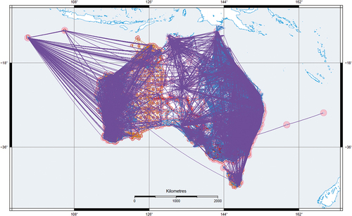
The data input into the NADJ includes the latest APREF solution, both the SINEX file and the GNSS baseline cluster, and the latest JADJ from each jurisdiction. The adjustment is run using DynAdjust on a compute-optimised AWS instance. Similar to the JADJ, the geoid correction is applied, the measurements are transformed to GDA2020, the network segmented, and the adjustment run. The national geodetic network is illustrated in .
Figure 4. The National geodetic network used to establish and maintain GDA2020. See Fraser et al. (Citation2022) for details on the symbology used in this diagram.
Results
The fundamental products from the NADJ are the station coordinates and their uncertainties. For each station, the Cartesian variance-covariance matrix (VCV) is provided along with the semi-major axis, the semi-minor axis, and the orientation of the error ellipse defined by the VCV. This error ellipse is converted into a circularised horizontal positional uncertainty and vertical positional uncertainty (ICSM Citation2020a). To account for possible monument movement, Type B positional uncertainties are added to the VCV post-adjustment.
Using the results of the November 2021 NADJ, the average horizontal positional uncertainty and the standard error for the RVS stations is 15.4 mm ± 1.6 mm and the average vertical positional uncertainty and the standard error is 25.0 mm ± 2.8 mm. For the full set of APREF stations (including the RVS stations) these numbers are only slightly larger. The average horizontal positional uncertainty and the standard error is 16.5 mm ± 2.8 mm, and the average vertical positional uncertainty and the standard error is 26.9 mm ± 4.2 mm.
For the full national geodetic network, the median is a more appropriate statistic to use, since the distribution of uncertainties is not Gaussian and has a long tail of large uncertainties. This is especially true for the vertical uncertainties since some stations have estimated heights, which require larger uncertainties. The median horizontal positional uncertainty of the full national geodetic network is 20.2 mm, and the median vertical positional uncertainty is 100.8 mm.
To transformation between GDA94 and GDA2020, the ICSM has created three different transformation products: a three-dimensional 7-parameter similarity transformation; a two-dimensional conformal grid; and a two-dimensional conformal + distortion grid.
The seven-parameter similarity transformation is a three-dimensional transformation used to transform three-dimensional data. It accounts for tectonic plate motion and is recommended for transforming GNSS data. The conformal-only grid replicates the behaviour of the seven-parameter similarity transformation and is designed to transform two-dimensional geographic data derived from GNSS observations. If the data was obtained through a connection to the survey control mark network, then the conformal + distortion grid is recommended.
Which transformation method to use will depend on where and how the data were collected and the size of the uncertainties (see Table 3.4 in ICSM Citation2021). Data with an uncertainty of less than 0.5 m should follow the recommendations in the table mentioned. For data with an uncertainty in the range of 0.5 m – 3.0 m, the conformal only grid is recommended. If the uncertainty of the data is greater than 3 m, then it is considered GDA2020 compatible and there is no need to transform.
Due to the change in the scale factor between ITRF92 and ITRF2014, ellipsoidal heights are ~9 cm less in GDA2020 than in GDA94. Therefore, an update to the AUSGeoid model was required to maintain compatibility with the Australian Height Datum (AHD). For more details on AUSGeoid2020 and its development, see Brown et al. (Citation2018).
To overcome the biases and distortions in AHD, Geoscience Australia has developed a new reference surface for heights called the Australian Vertical Working Surface (AVWS; ICSM Citation2020c). The AVWS is a gravity model that provides the offset between the ellipsoid and quasigeoid, and heights can be computed with uncertainties of 4–8 cm, compared with 6–13 cm for AHD heights.
Discussion
We have presented Geocentric Datum of Australia 2020, the latest update to the Australian national datum. Major improvements include the removal of the distortion in the network, a reduction in the coordinate offset to ITRF, and the provision of rigorous uncertainties.
The national geodetic network consists of more than 330,000 stations and their coordinates are estimated via a rigorous least-squares adjustment of more than 2.4 million measurements. This continental-scale adjustment, a first for an Australian datum, was made possible by the phased adjustment capabilities of DynAdjust.
For the full national geodetic network, the median horizontal positional uncertainty is 20.2 mm, and the median vertical positional uncertainty is 100.8 mm. The vertical positional uncertainty is higher than expected (given the horizontal positional uncertainty) because GDA94 was realised using only terrestrial measurements and so is only 2D. Therefore, many stations lacked height information and required approximate heights with appropriately large uncertainties to be included in the adjustment. The APREF network and the RVS sub-network offer increased accuracy with the latter having an average horizontal positional uncertainty of 15.4 mm an average vertical positional uncertainty of 25.0 mm.
The GDA2020 coordinate set and uncertainties are not the only product of the GDA2020 update process. Using the PMM, GDA2020 coordinates can be propagated to a different epoch. This enables ATRF2014, a time dependent terrestrial reference frame that will remain aligned with ITRF, which allows for the conduct of high-accuracy science and interoperability with systems that work in the international reference frame rather than GDA2020.
Altogether, GDA2020, ATRF2014, the PMM, the transformation grids, AUSGeoid2020, AHD, and AVWS comprise the AGRS. This modernised reference system is well-suited to high accuracy positioning that is often required, while at the same time it retains the capabilities of the previous version for those that do not require such accuracy. It has been designed to be easily updated and/or improved as needed, and it is hoped that it will remain suitable to Australia’s positioning needs for many decades.
Acknowledgments
The authors would like to acknowledge the contributions of the many people that were involved in the production of GDA2020 over the last decade. The cooperation required to complete this project was provided by the ICSM Geodesy Working Group and its Adjustment Working Group. The former was responsible for the overall guidance of the project while the latter worked to troubleshoot problems and to ensure that the NADJ was suitable for the needs of all jurisdictions. Both these working groups contained geodetic experts from all jurisdictions in Australia and their advice and work were invaluable. The authors would also like to acknowledge the work that goes into developing the products that feed into the GDA2020 update process and would like to thank the GNSS Analysis and GNSS Operations teams at GA. The quality of the results of this work are directly related to the quality of their work. Finally, we would like to thank Anna Riddell for her many close readings of the manuscript. Your comments and suggestions have improved it greatly.
Disclosure statement
No potential conflict of interest was reported by the author(s).
References
- Altamimi, Z., et al., 2016. ITRF2014: a new release of the International Terrestrial Reference Frame modeling nonlinear station motions. Journal of Geophysical Research: Solid Earth, 121. doi:10.1002/2016JB013098
- Altamimi, Z., Sillard, P., and Boucher, C., eds., 2006. CATREF software combination and analysis of terrestrial reference frames. https://www5.obs-mip.fr/wp-content-omp/uploads/sites/28/2017/11/CATREF-1.pdf
- Boucher, C., Altamimi, Z., and Duhem, L., 1993. ITRF92 and its associated velocity field. IERS Technical Note, 15, 164. Observatoire de Paris.
- Brown, N.J., et al., 2018. AUSGeoid2020 combined gravimetric–geometric model: location-specific uncertainties and baseline-length-dependent error decorrelation. Journal of Geodesy, 92 (12), 1457–1465. doi:10.1007/s00190-018-1202-7
- Brown, N.J. and Tregoning, P., 2010. Quantifying GRACE data contamination effects on hydrological analysis in the Murray–Darling Basin, southeast Australia. Australian Journal of Earth Sciences, 57 (3), 329–335. doi:10.1080/08120091003619241
- Dach, R., et al., eds., 2015. Bernese GNSS software version 5.2. Astronomical Institute, University of Bern, Bern Open Publishing. doi:10.7892/boris.72297.
- Dawson, J. and Woods, A., 2010. ITRF to GDA94 coordinate transformations. Journal of Applied Geodesy, 4 (4), 189–199. doi:10.1515/jag.2010.019
- Donnelly, N., et al., 2014. Progress towards a new geodetic datum for Australia. In: FIG congress, 16-21 June 2014, Kuala Lumpur, Malaysia.
- Fraser, R., Leahy, F., and Collier, P., eds., 2022. DynAdjust user’s guide version 1.2. Geoscience Australia. Available from: https://github.com/icsm-au/DynAdjust.
- Fraser, R.W., Leahy, F.J., and Collier, P.A., 2023. Automatic segmentation and parallel phased least squares for highly efficient geodetic network parameter estimation. Survey Review, 1–19. doi:10.1080/00396265.2022.2163138
- Haasdyk, J., Davies, L., and Watson, T., 2014. Progress towards a new geodetic datum for Australia. In: Proceedings of the 19th association of public authority surveyors conference, 31 March – 2 April 2014, New South Wales, Australia.
- Hu, G., Jia, M., and Dawson, J., 2019. Report on the Asia Pacific Reference Frame (APREF) project. Geoscience Australia, record 2019/17. doi:10.11636/Record.2019.017
- Intergovernmental Committee on Surveying and Mapping (ICSM), 2014. Geocentric Datum of Australia technical manual, version 2.4.
- Intergovernmental Committee on Surveying and Mapping (ICSM), 2020a. Guideline for the adjustment and evaluation of survey control - special publication 1, version 2.2.
- Intergovernmental Committee on Surveying and Mapping (ICSM), 2020b. Standard for the Australian Survey Control Network Special Publication 1, version 2.2.
- Intergovernmental Committee on Surveying and Mapping (ICSM), 2020c. Australian Vertical Working Surface (AVWS): technical implementation plan, version 1.1.
- Intergovernmental Committee on Surveying and Mapping (ICSM), 2021. Geocentric Datum of Australia 2020 technical manual, version 1.7.
- Intergovernmental Committee on Surveying and Mapping (ICSM), 2022. Australian Geospatial Reference System compendium, version 1.0.
- Johnston, G., Riddell, A., and Hausler, G., 2017. The International GNSS Service. In: P.J. Teunissen and O. Montenbruck, eds. Springer handbook of global navigation satellite systems. Cham: Springer Handbooks. Springer, 967. doi:10.1007/978-3-319-42928-1_33
- Mitrovica, J.X., Milne, G.A., and Davis, J.L., 2001. Glacial isostatic adjustment on a rotating earth. Geophysical Journal International, 147 (3), 562–578. doi:10.1046/j.1365-246x.2001.01550.x
- Riddell, A.R., King, M.A., and Watson, C.S., 2020a. Present‐day vertical land motion of Australia from GPS observations and geophysical models. Journal of Geophysical Research: Solid Earth, 125, e2019JB018034. doi:10.1029/2019JB018034
- Riddell, A.R., King, M.A., and Watson, C.S., 2020b. Ongoing postseismic vertical deformation of the Australian continent from far-field earthquakes. Earth and Space Science Open Archive. doi:10.1002/essoar.10504158.1
- Riddell, A., Moore, M., and Hu, G., 2015. Geoscience Australia’s GNSS antenna calibration facility: initial results. In: IGNSS symposium, Gold Coast, Queensland, Australia.
- Thomas, I.D., et al., 2011. Widespread low rates of Antarctic glacial isostatic adjustment revealed by GPS observations. Geophysical Research Letters, 38 (22). doi:10.1029/2011GL049277
- Tienstra, J.M., 1956. Theory of adjustment of normally distributed observations. Amsterdam: Argus.
- Tregoning, P., et al., 2013. A decade of horizontal deformation from great earthquakes. Journal of Geophysical Research: Solid Earth, 118 (5), 2371–2381. doi:10.1002/jgrb.5015
Appendix A
This appendix provides more details on the NGCA processing.
The IGS products used for processing include the GPS satellite ephemerides, satellite and station clocks, Earth rotation parameters, and troposphere delay estimates. The best available IGS products are used, with the type depending on the amount of time that has passed since the observations were collected. If it is less than two days then the Ultra-Rapid products are used, if it is less than two weeks then the Rapid products are used, and if it is greater than two weeks then the Final products are used. Provided all solutions are ambiguity fixed, the differences in the coordinates produced by each of these products are small, amounting to 1–2 mm horizontally and 3–5 mm vertically between a solution using the Rapid products compared with one using the Final products. With the Ultra-Rapid products, which are rarely ever used, the differences compared with the Final products solutions increases to 5 mm horizontally and 10 mm vertically.
As Bernese estimates a network solution, the NGCA RINEX files are organised into clusters and processed together, thereby obtaining the covariance information between the stations. Clusters are created by grouping RINEX files that overlap temporally, with every file in the cluster having at least 2 hours of overlap with every other file in the cluster. To obtain the best solution possible, 15 APREF CORS are used as reference stations – the nearest 7 IGS CORS and the nearest 8 non-IGS CORS. The former provides a good connection to ITRF, and the latter improves the fit locally. A SINEX file is produced for each cluster with the station coordinates given in ITRF2014 at the epoch of observation and with stations outside the extent of GDA2020 removed (see ).