
ABSTRACT
The focus of this paper is on regionality, the use of main territories and how they are interlinked in the Mesolithic in south Norway during the culmination of the settlement of the mountain area, 8500–7600 cal BP. The main territories and their boundaries are identified by the distribution of specific lithic raw materials and one artefact type, distribution of ungulates and drainage systems. In the Mesolithic, south Norway corresponds to a language family with four dialectic tribes, each one corresponding to a main territory. Based on ethnographic analogies, the inegalitarian higher latitude boreal hunter-gatherer societies had delayed return. The subsistence strategy may have included the defence of resources which were plentiful, concentrated and predictable, with ownership of resource-rich locations such as salmon runs and quarries, while unreliable resources such as unpredictable ungulates may not have been defended. Storing may have resulted in a sedentary period during the yearly round close to resource-rich areas along rivers and coasts. The presence of a cemetery by the seashore at Hummervikholmen, indicates lineal descent groups, linking territories to funerary behaviour. Territorial lineages may have existed, with formal areas for disposal of the dead at least along resource-rich riversides and seashores. However, these may have been destroyed by erosion and other destruction processes. Lithic markers indicate that foragers from the four main territories maintained a network of links following the drainage systems and crossing the mountain area in the Central Main Territory, which was temporarily settled by people from the other main territories. Here, people from different directions could meet during the warm season hunting reindeer. In the river sources around the water divide areas, people may have had meeting places, exchanging information over large areas of south Norway. The activities at the meeting places were connected to a reindeer culture with long diasporic traditions reaching back to their origin at the lateglacial Continent. Reindeer are proposed to have had a central role in the grouping of the main territories.
Introduction
Nature and climate influence the cultural characteristics of hunter-gatherers, their movements in the landscape and the size of their land-use area. Hunter-gatherers have a detailed knowledge of the use of resources in their territory, including large areas far outside their seasonal activity rounds (Lee Citation1979; Brody [Citation1981] Citation2002a, [Citation2000] Citation2002b; Kelly Citation1995; Grøn Citation2012). Foraging is a way of life, not just a method of subsistence, and peoples’ visions of society are in essence economic (Barnard Citation2002, Citation2017). The landscape is the fundament in which individual consciousness and social identities are anchored (Tilley Citation1994). When determining the environmental, economic and social factors for a region, the networks in space, their extent, structure and limits could vary considerably (Madden Citation1983).
The focus of the paper is on regionality, the use of main territories and how they are interlinked in the Mesolithic in south Norway during the culmination of the settlement of the mountain area, 8500–7600 cal BP and based on radiocarbon dates as a record of the Mesolithic settlement in the mountain area. The proposed concept of main territories is built on lithic material used in the material culture, environmental (economic and topographical) elements, social networks, mobility and organisation of space.
The Geographical Setting
The Weichselian ice cap melted in the mountain area around 10,000 cal BP (Vorren and Mangerud Citation2007). South Norway has a diverse natural environment, with many islands along the coast. The drainage systems are short in the west and north compared to the east and south, which drain very large areas. The interior is mountainous, with peaks below 2500 metres above sea level and environmental zonation. Vegetation ripens sequentially from the lowland to the mountain area with the seasons and with changes in the fauna. South Norway is located in the boreal vegetation zone, dominated by coniferous forest. Four altitudinal zones characterise the vegetation: the coastal forest, the boreal forest, the subalpine forest and the alpine area above the forest limit (Selsing Citation2016; see also Moen Citation1998). From the rivers and coastal zone there was access to both terrestrial and marine resources in the Mesolithic. The climate is maritime in the west and more continental in the east. According to thermal vegetation indicators, the climate was stable during the Holocene Thermal Maximum around10,000–7500 cal BP (Paus Citation2013; Hanssen-Bauer et al. Citation2015). Less precipitation and a temperature during the warm season about 1–2°C higher than today (1971–2000) characterised the climate and restricted the treeless mountain area above the forest limit. Later the climate was more unstable, cooler and humid.
The radiocarbon dates were converted to calibrated ages (cal BP) using OxCal programme (v. 4.2) based on the IntCal13 calibration curve (Bronk Ramsey Citation2009; Reimer et al. Citation2013). The archaeological chronology used is Early Mesolithic 11,500–10,200 cal BP, Middle Mesolithic 10,200–8400 cal BP and Late Mesolithic 8400–6000 cal BP.
Using Ethnographic Analogies
Ethnographic analogy was used to interpret the archaeological and natural history records and hunter-gatherers’ relationship to nature. I have elaborated the statements and generalisations to make them probable and meaningful to support my arguments about south Norway.
The concept of territoriality has been discussed for a long time and several details are important and useful as a background to understanding Mesolithic higher latitude boreal hunter-gatherer societies in south Norway.
Territories
Peterson (Citation1975) discussed a definition and function of territorial behaviour in Australian Aborigines and stated that people are territorial and evolved in societies. As stated by Brody ([Citation1981] Citation2002a, [Citation2000] Citation2002b) based on studies of boreal Canadian hunter-gatherers, foragers’ attachment to a place does not derive from a formal process.
The discontinuities in the physical environment regulate the distribution of populations and therefore people usually are clustered (Peterson Citation1975). Dyson-Hudson and Smith (Citation1978) pointed to clustering of individuals because of a sufficient degree of resource unpredictability. Hunter-gatherers form discontinuous, local population aggregates of social groups, which may give rise to communication networks (Newell et al. Citation1990). People are attached to areas where their requirements are met, and these areas may contain the germ of territorial rights (Peterson Citation1975). The advantages of adjusting group size to resources is the regulation of population dispersal over an area through the territoriality (Peterson Citation1975).
A precise anthropological definition of territoriality proposed by Dyson-Hudson and Smith (Citation1978) is that of a local group occupying and defending a particular area, as tested on two cases of North American indigenous people and Karimojong in Uganda.
Layton (Citation1986) emphasised hunter-gatherers’ adaptive response to ecological variables as a major factor determining territoriality, even if social mechanisms control and level out the distribution and access to productive resources. The proposed model of spatial organisation focused on resource distribution and economic defendability in case studies on Australian Aboriginal hunter-gatherers. Benefits of territoriality result from exclusive access to critical resources and the cost–benefit ratio of a territorial strategy is dependent on the pattern of resource distribution, predictability and abundance (Layton Citation1986).
Inegalitarian hunter-gatherer social systems have delayed return, usually in fixed dwellings and with rights over valued assets, among others processed and stored food and improved wild products, but with some restricted immediate-return activity (Woodburn Citation1982). The record of hunter-gatherers in south Norway has characteristics of Woodburn’s (Citation1982) inegalitarian political society and Layton’s (Citation2005) delayed return higher latitude groups with predictable and high seasonal variation in resource productivity. These societies are technologically complex and use storage of food to procure temporarily available resources in bulk and preserve them. Layton (Citation1986) stressed the control over land, and its unharvested resources, and especially storage, and sharing. Storage becomes more feasible in higher latitudes because it is both possible in cold climates and desirable, and it occurs in bursts with seasonal availability of food (Binford Citation1980; Layton Citation2005).
Simple storage such as drying and smoking requires no resources except for what is already at a settlement site in the Mesolithic of south Scandinavia (Schaller Åhrberg Citation2007). Other simple types of storage possible in south Norway were depositing in water and freezing in snow and ice, recorded for Canadian and proposed for Late Paleolithic hunter-gatherers (see, e.g. Brody [Citation1981] Citation2002a; Grønnow [Citation1985] Citation1987).
Storing was probably widespread in south Norway during the Mesolithic, as in inegalitarian hunter-gatherer social systems with delayed return today. It is, however, difficult to reveal in the archaeological record, with little organic material left. Storing of food has been recorded from the Norwegian Mesolithic; remnants of reindeer in the lowlands transported away from the mountain area (H. Olsen Citation1976; Bjørgo Citation1981; Randers Citation1986; Gustafson Citation1987, Citation1988; Hufthammer Citation1988; Lie Citation1988) and marine fish in the mountain area interpreted as travelling provisions (Randers Citation1986).
Natural features, e.g. prominent landforms, often mark territorial boundaries (Tilley Citation1994). Unlike resource-poor areas, in resource-rich areas the environment can support a significantly larger population density with smaller and more clearly defined territories and a greater degree of boundary maintenance is practised (Pardoe Citation1988). This finding was based on studies of prehistoric Aboriginals in south-eastern Australia.
Territorial Ownership by Lineages
Some hunter-gatherers use the presence of ancestors in a cemetery to justify their occupation of a particular area (Goldstein Citation1981). The Saxe-Goldstein hypothesis is that the presence of a cemetery indicates the presence of a unilineal descent group linking territorial ownership to funerary behaviour of delayed return groups (Saxe Citation1970; Goldstein Citation1981; see Rowley-Conwy and Piper Citation2016). Layton’s (Citation2005) higher latitude groups with high seasonal variation in resource productivity included territorial and property ownership by lineal descent as a factor of major importance.
Transposed to the south Norwegian Mesolithic, hunter-gatherers with delayed return they may have had disposal areas of their dead. The bone fragments of five different skeletal (9400–8500 cal BP) at Hummervikholmen on the south coast located in a protected seabed inlet at one metre’s depth confirm the existence of a burial tradition (Sellevold and Skar Citation1999; Skar et al. Citation2016). The skeletal remains found in refuse heaps in Vistehulen in the coastal south-west and Grønehelleren in the coastal west probably do not represent funerary activities (Lund Citation1951; Jansen Citation1972; Lillehammer, Lundström, and Thomsen Citation1995; Sellevold and Skar Citation1999).
That a reliable account of a burial is recorded may indicate that lineal claims existed. Perhaps it was a weak and not particularly widespread tradition with low dependence on the ancestors and few group rights to use and legitimise resources. It is likely that the foragers practised another form of handling the dead than what is documented in south Scandinavia (e.g. Albrethsen and Brinch Petersen Citation1976; Larsson Citation1989). People may have legitimised territoriality by means other than a cemetery. Non-formal methods of disposal of the dead could have been casual disposal practices leaving no evidence in the archaeological record, for example, places where the dead were left without traces on the surface (e.g. Rasmussen [Citation1932] Citation1955; Pardoe Citation1988; Knutsson Citation1995; Andersen Citation2016). Material traces, such as axes and ochre, have been used in relation to and as possible markers of the dead, giving the material culture in south Scandinavia and south Norway a communicative role (e.g. Albrethsen and Brinch Petersen Citation1976; Larsson Citation1982; Bergsvik Citation1988; Kannegaard Citation2016).
The sparseness of recorded burials does not necessarily mean that lineal Mesolithic descent groups did not exist in south Norway. The sea level regression minimum of about minus two metres (Midtbø, Prøsch-Danielsen, and Helle Citation2000) at the time of the Hummervikholmen people may indicate that there could have been a preference for depositing the dead close to the seashore. Here, the likelihood of finding the sites is low because of sea level changes around the south Norwegian coasts (e.g. Hafsten Citation1983; Midtbø, Prøsch-Danielsen, and Helle Citation2000) which may have caused erosion that destroyed the burial sites.
Pardoe (Citation1988) recorded prehistoric cemeteries only along the rivers in south-eastern Australia and argued that they indicated the presence of territorial lineages. Resident groups with control of the river could claim ownership indicated by cemeteries as handed down from ancestral groups maintained over long periods. Transposed to the Mesolithic in south Norway, it is possible that there may have been a preference for depositing the dead, may-be in cemeteries, at riversides in areas with stable and predictable resources useful for territorial lineage groups. However, possible burials along riversides may have been exposed to erosion and destruction many times through the ages as south Norwegian rivers flood at least once a year (Roald Citation2013).
It could be that the hunter-gatherers in south Norway, according to the Saxe-Goldstein hypothesis, used the presence of the ancestors to justify their occupation of the landscape to indicate territorial lineages linking territorial ownership to funerary behaviour of delayed return groups at least in resource rich areas. Such an interpretation would be in agreement with Layton (Citation2005): higher latitude groups in areas with high seasonal variation in resource productivity had territorial and property ownership by lineal descent.
This argumentation may be reliable for resource-rich areas in south Norway, both along the coast and along riversides. Disposal of the dead may originally have occurred because of lineal descent groups, which linked territorial ownership to funerary behaviour of delayed return groups.
What is a Main Territory?
Social units express the relationship between land, people and language. Hunter-gatherers group together in a regional community of several tribes, such as the Kulin Group and Kurnai Group of south-east Australia (McBryde Citation1984). Related intelligible languages and distinct social organisation unite them (McBryde Citation1984).
Based on this a main territory is defined by linguistic boundaries and is of a higher level than territories. A main territory corresponds to a dialectical tribe overlapping and occupying several territories. People in a dialectical tribe speak the same dialect (see Birdsell Citation1968; McBryde Citation1984; Newell et al. Citation1990).
Main territories comprise several territories in a region occupied by a dialectal tribe. Proposals to delimit Mesolithic hunter-gatherers’ organisation of space, territories or smaller groups of territories in south Norway have been presented earlier (Olsen and Alsaker Citation1984; Mikkelsen Citation1989; Fuglestvedt Citation1998; Falkenström Citation2003; Skjelstad Citation2003; Gundersen Citation2004; Ballin Citation2007). Lithic raw material distributed across several territories was important to establish territories.
I have chosen three subjects to identify main territories and their boundaries: (1) the distribution of three selected characteristic lithic raw materials and one artefact type, (2) distribution of ungulates and (3) river systems. They are discussed in separate sections below.
I propose that the boundaries of the distribution of these lithic raw materials and the chosen artefact type were a result of people’s choices as an important part of the material culture. The lithic raw materials were important to establish the Western and Eastern Main Territories, while the Nøstvet axes established the Southern Main Territory in a later phase.
Ungulates were important regionalised prey. They contribute to the definition of main territories to differentiate the Western Main Territory, with predominantly red deer, and the Central Main Territory, with reindeer.
Communication within the main territories and between lowlands and the mountain area happened primarily along the river systems. The boundaries between the main territories corresponded to water divides. The main water divide in the mountain area includes the sources between large river systems draining in different directions and establish the Central Main Territory.
Based on the distribution of the chosen three subjects, five main territories are identified in south Norway, described in separate sections below. Present-day south Norway may have corresponded to a language family (Newell et al. Citation1990). The competence in speech, dialectal homogeneity, is a consequence of spatial proximity and density of communication involving frequency, intensity and duration of interaction (Birdsell Citation1968). The identification and definition of the dialectic tribe includes that they share a common culture and each band forms a part of a larger social universe (Newell et al. Citation1990).
Language area networks are of structural significance in the organisation of human populations going beyond the local group and they reflect patterns of language similarity and provide for easier shifts across linguistic boundaries (Hill Citation1978). In this way, dialectic groups will have access to long-distance communication systems for the purpose of, for example, trade and visiting.
The main territorial structures in south Norway are adapted to ecological terms. For the Paiute tribe of the southern Sierra Nevada in the USA, the steep topography with environmental zonation resulted in a diversity of resources. Thus, necessary food could be obtained within relative short distances (Dyson-Hudson and Smith Citation1978). This situation corresponds to the south Norwegian zones of alternating resource types. People relied on a food supply, concentrated in the environment and changing with the seasons.
Some resources may have been defended and others not according to the variety of utilisation of different resources with respect to predictability, abundance and mobility (Dyson-Hudson and Smith Citation1978). As indicated by Layton (Citation1986, Citation2005; see also Rowley-Conwy and Piper Citation2016 with reference to Richardson Citation1982), groups of people may physically defend territories only when the resources they contain are considerable, concentrated and predictable. This means that salmon runs at specific places at the south Norwegian west coast, and quarries (see below), may have been defended and other people may have been denied access to these resources. For the south Norwegian Mesolithic hunter-gatherers this could mean more emphasis on ownership of resource-rich sites and no or little defence of moderate and not easily accessible resources.
Lithic Raw Materials
Aside from charcoal, few organic materials are left in the Mesolithic Norwegian archaeological record. However, lithic raw materials are abundant and probably culturally preferred. Disparate groups of cultures prefer certain general similarities in lithics. Like Sulgostowska (Citation2006b) who suggested for final Palaeolithic Magdalenian hunter-gatherers in Poland that use and distribution of local and exotic flint were important and considered as markers of group mobility and inter-group contacts, I have favoured lithics which are easy to recognise macroscopically with known source area which indicates origin, distribution and connections. Schaller (Citation1984) proposed that for Mesolithic hunter-gatherers in south Norway the choice of lithic was probably both conscious and intentional.
Lithic raw materials and special artefacts are commonly employed as proxies of movement for the south Norwegian Mesolithic hunter-gatherers material culture’s communication system and identity, and may have had a central role in separating territories (Sjurseike Citation1994). Falkenström (Citation2003) maintained that social boundaries reflected through the choice of lithic raw materials in central Scandinavia during the Mesolithic could be attributed to identity and territorial behaviour. The purpose of lithic procurement practices could have been to maintain social networks and define regional differentiation between groups (Falkenström Citation2003; Nyland Citation2017).
Because of superior social networks, where individuals move between social units, the material culture used to define the boundaries of a territory is also often found outside this territory (Newell et al. Citation1990). Material for high-performance tools may have been utilised over great distances, linked to social status, a statement based on studies of hunter-gatherers in the north Norwegian Mesolithic and the Labrador maritime Archaic (Hood Citation1995) and in high altitudes in the French Alps (Walsh Citation2005). By understanding the signs at sites visited by the ancestors, hunter-gatherers could recognise, read and understand previous visits, activities and events.
Opportunistically procured rock types with the hardness of siliceous rocks, often of local and unidentified origin such as quartz, quartzites and rock crystal, are available in many places in south Norway and dominate in the material culture of Mesolithic lithic tools (e.g. Sjurseike Citation1994; Nyland Citation2016; Ballin Citation2018). The considerable typological similarity between tools of quartzite and flint (Indrelid [Citation1986] Citation1994) shows that the two raw materials were interchangeable.
Flint was a commonly used lithic raw material in south Norway and may have had a special role in Mesolithic societies. There is no autochthonous flint in the Norwegian bedrock. It was collected from unconsolidated deposits along the coast up to more than 200 metres above the present sea level (Sejrup et al. Citation1998; Berg-Hansen Citation1999). With this origin, flint artefacts in the mountain area indicate an identity marker of contact between hunter-gatherers who used the coast and the mountain, respectively (e.g. Mikkelsen and Nybruget Citation1975; Hood Citation1991; Fuglestvedt Citation1998). Erratic flint may have symbolised the coastal landscapes and portable flint may have mediated coast-inland relations (Hood Citation1988; Selsing Citation2012; see also Conkey Citation1984). This may explain why small amounts of flint are found at nearly all sites in the interior.
Continued use of some quarries signals an important place apparently assigned significance beyond being a source of high-quality rock suited for tool production. Therefore, the distance may have been inconsequential compared to lithic quality, as proposed for central and south-eastern Australian Aborigines and south Norwegian hunter-gatherers in the Mesolithic (e.g. McBryde Citation1984; Olsen and Alsaker Citation1984; Gould and Saggers Citation1985; Nyland Citation2006). Mechanisms must have existed for the transfer of goods to external territories, as recorded for south-eastern Australian Aborigines (McBryde Citation1984).
McBryde (Citation1984) pointed to distinct and positive spatial correlations between the artefact distribution in the archaeological record and other aspects of culture documented in the anthropological record. The south-eastern Australian greenstone quarry at Mt. William is important, valued and controlled, with the lithic used as a prestige good in intergroup exchanges and ceremonial gatherings to strengthen social and political bonds and contracts (McBryde Citation1984). People outside the land-owning group also seem to have had rights to this place and access to its resources because of different types of relationship that link members of different clans (McBryde Citation1984). Ethnographically a control of rights, ownership and management of this resource-rich site may indicate control and probably also defence and ownership by lineal descent of the Norwegian quarries during the Mesolithic. They may have been defended, given the concentration and predictability of a valuable resource (see Layton Citation1986, Citation2005). Knowledge of the availability and quality of the raw material can yield control, giving the raw material a conservative and preservative role in the society (Sjurseike Citation1994).
A quarry with specific lithic materials can function as an arena for the transfer of knowledge, social reproduction and identity, integrating the sacred and the profane in the same procurement processes suggested by Sjurseike (Citation1994) for the south Norwegian Mesolithic hunter-gatherers. This may be confirmed by repeated visits and an insistence on using rock from specific places, despite other rock types of equal quality being accessible elsewhere, or traditions of collecting poor quality lithic material from a special source far away (Sjurseike Citation1994; Nyland Citation2017). However, in my opinion as regards better or worse quality, it is likely that a good enough quality of silicic rocks was adequate regardless of the distance, but the importance lay in it’s value as a social marker.
The communicative strength of material culture has an active role in defining group relations (Barth Citation1969). The Mesolithic areas might have been defended by using rare and exotic materials as social symbol markers to indicate people with contacts in a network (Sjurseike Citation1994; Falkenström Citation2003).
The selected lithic materials in this study were procured in specific quarries. They are the Hespriholmen greenstone, the Stakanes diabase and the Skardlia jasper, and one characteristic artefact, the Nøstvet axe (drawing of a Nøstvet axe, see Østmo and Hedeager Citation2005). Olsen and Alsaker (Citation1984) and Sjurseike (Citation1994) presented distribution maps of the three chosen lithic raw materials. Other lithic raw materials in south Norway that are easy to identify macroscopically are not distributed as widely as the selected ones.
Greenstone from the Hespriholmen quarry is recorded at archaeological sites in the southern part of west Norway, sporadically further south-east and in the mountain area at Hardangervidda (Alsaker [Citation1982], Citation1987; Olsen and Alsaker Citation1984; Indrelid [Citation1986] Citation1994). Further north on west Norwegian coastal sites, Stakanes diabase artefacts are procured in a quarry east of Florø, and occur quite commonly as far north as Trondheimsfjorden and then sporadically even further north (Olsen Citation1981; Bergsvik Citation2002b; Bergsvik and Olsen Citation2003). The quarries were easily accessible from many areas by boat.
In the east, hunter-gatherers had a lithic tradition of procuring a characteristic jasper based on the quarry north of Trysil, 850 metres above sea level (Sjurseike Citation1994). The jasper artefacts occur at many Mesolithic sites over a large area.
It has not been possible to identify a specific lithic north and south of the distribution of these three characteristic lithics. Thus, the northern and southern part of south Norway is characterised by the lack of special lithic markers. In the south, the Nøstvet tradition was established before 7900 cal BP with the characteristic Nøstvet axes.
The Drainage System
The drainage systems were chosen to define the main territories because the rivers were important for transportation and as a communication system as well as a water supply, and for fishing and the collection of other resources in the river and at the margins. Canadian hunter-gatherers considered the river systems as the heart of their traditional land use (Brody [Citation1981] Citation2002a). Hunter-gathers may have seen the total area drained by rivers from the open sea via fjord and river to the watershed as eternal. The drainage systems meet at the watershed with little or no distance between adjacent springs draining in different directions.
Based on studies of Mesolithic people in northern England, Spikins (Citation1996) proposed that watercourses make communication continuous and flexible, and facilitate orientation in the landscape. Rivers acted as a structuring element, concentrated migrations and connected societies, as proposed for the Mesolithic in south-east Norway (Melvold Citation2006). Drainage systems were probably important migration routes for animals and people and the core area for foragers’ use of the landscape, which may define a territory proposed by ethnologists and archaeologists (e.g. Pardoe Citation1988; Spikins Citation1996; Siemaszko Citation1999; Howard et al. Citation2015).
Hunter-gatherers may have organised their territories around drainage systems, with the boundaries between the drainage systems as proposed for Mesolithic hunter-gatherers in England and Scandinavia (e.g. Falkenström Citation2003; Lødøen and Mandt [Citation2005] Citation2010; Evans et al. Citation2010). An objective reason for this may be that people used the rivers as their main transportation routes. Evenk hunters in Siberia used markers around central sites of the main traffic rivers (Grøn Citation2005).
The rivers offer a good view. Conversely, dense forests make trips slow and laborious. People may have chosen to follow the river where it was necessary to maintain communication systems, as stated by Rasmussen ([Citation1932] Citation1955) about northern Canada. Seasonal frozen watercourses make transport on the ice easy. Chains of valleys with river and lake systems in south Norway may have been important communication routes, as confirmed by many recorded Mesolithic sites.
For the final Palaeolithic in Poland, Sulgostowska (Citation2006b) recorded expeditions using such natural routes as river valleys, but also crossing mountains. The motives for these seasonal events with distances of more than thousand kilometres may have been connected with economic necessity and subsistence strategy.
The banks of rivers in south-east Australia were described by Pardoe (Citation1988) as some of the few places with extreme variations in resources over a small area and thus a reliable lifeline for food and water. An alternative to increased work effort in hunting ungulates in south Norway may have been to live more permanently in areas close to rich and predictable year-round resources along rivers that may have stabilised territorial lineages, as also proposed by Peterson (Citation1975) for groups in arid areas of Australia.
The Main Ungulate Prey
The reason for choosing the main ungulate prey for defining the main territories is their regional distribution, with mainly red deer (Cervus elaphus) in the west and elk (Alces alces) in the south, east and north. This differentiation also existed in the Mesolithic but was probably not as pronounced as today (Langvatn Citation1980; Olstad and Krafft Citation1980; Reimers Citation1980; Lie Citation1988, Citation1989). Reindeer (Rangifer tarandus) dominated in the mountain area then as today, with elk, and red deer in the forest. Reindeer are easy to exploit because they are gregarious compared to the solitary animals, dispersed throughout the environment (Kelly Citation1983). The three ungulates meet in the upper valleys, as indicated by archaeological sites (Mikkelsen Citation1989). It is likely that all three big fleshy ungulates competed for the pastures in this zone where hunter-gatherers had access to them. They required different hunting techniques because of different behaviour (Indrelid Citation1978; Gustafson Citation1988; Mikkelsen Citation1989). Like today, the hunters probably took advantage of the seasonal optimal conditions of meat, hide and fat.
In general, the fauna in the boreal forest is not easily accessible to hunters. The density of the forest may be an important reason for the often, high residential mobility of hunter-gatherers (Winterhalder Citation1981; Kelly Citation1983, Citation1995). Organised, intentional and systematic fire management of the forest may have concentrated resources, making them more predictable and improving accessibility, and thus the outcome of the hunt (Simmons Citation1975; Mellars Citation1976; Simmons and Innes Citation1987; Scherjon et al. Citation2015; Selsing Citation2016).
While the Northern Ojibwa living east of Lake Superior in Canada were dependent on highly mobile and therefore relatively unpredictable large game such as reindeer and elk as a major resource, they did not defend territories (Dyson-Hudson and Smith Citation1978 with reference to the studies of Bishop Citation1970, Citation1974). When the large game disappeared, they were forced to rely on small game, which probably did not yield the same subsistence base as the large game. The small game were less mobile and therefore more predictable and the people began to defend hunting territories. This example of changes in territoriality confirmed the predicted model of Dyson-Hudson and Smith (Citation1978) focusing on economic defendability of a resource area that may develop even when resource abundance declines and when the decline is compensated for by increased predictability of key resources. Transposed to the Norwegian Mesolithic hunter-gatherers, this could mean that large games were little defended because the access to ungulates was difficult.
The highly mobile Paleoindian groups of the Folsom cultural complex in the south-west USA saw decreased family size and increased diet breadth during seasons when large mammals were not the primary resource and the opposite case was also true (Amick Citation1996). This may also have been the response for the south Norwegian hunter-gatherers in the Mesolithic if ungulates were too few.
The rock art points to the importance of certain animals in the Norwegian Mesolithic (Mikkelsen Citation1977; Lødøen and Mandt [Citation2005] Citation2010; Nash and Smiseth Citation2015; Fuglestvedt Citation2018). Rock art may indicate the difficulty in hunting, and the scarcity of large, meaty ungulates which offered more food than marine resources (Simmons Citation1975; Sognnes Citation2017). Ungulates dominate in rock art. Compared to northern Norway, very few maritime images are present in south Norway, which indicates the importance of the ungulates for the hunter-gatherers in the south. Rock art may have been the expression of a need to mark boundaries with symbols of significance in terms of identity and social memory (Wrigglesworth Citation2006; Sognnes Citation2017). The foragers could hold rights over the rock art, as recorded by Layton (Citation1986) for sacred sites.
Rock art may imply a strong relationship between foragers and big game in the Mesolithic (Fuglestvedt Citation2018). Ritual places, such as rock art sites, may have been a key to creating the permission from the animals through the shaman’s involvement (Dowson Citation2009). Hunter-gatherers could have revisited the rock art by using waterways for communication (Helskog Citation1999) and travel to and from the mountain area. Rock art sites could have contained information that foragers with the same cultural identity could understand (Wrigglesworth Citation2006), maybe people from the same dialectal tribe.
Data Material of Four Main Territories
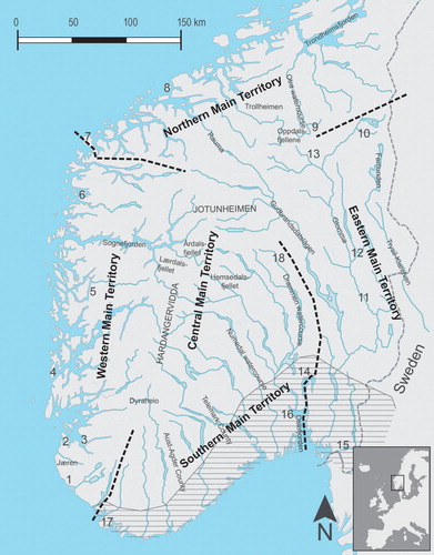
My data material is collected literature about the distribution of selected lithic raw materials and one artefact type used in the material culture, main ungulate prey, main drainage systems, selected sites, and the boundaries between the main territories in south Norway. The main territories are the result of interlinking this material. A main territory includes several drainage systems with boundaries located at the water divide between them. The four main territories stretch from the coast to the fifth Central Main Territory, which comprises the mountain area ().
Figure 1. Four main territories and the Central Main Territory: the mountain area. (1) Salthelleren, (2) Vistehola, (3) Botne, (4) Bømlo, (5) Skipshelleren, (6) Flora, (7) Stad Headland, (8) Aukra, (9) Falningsjøen, (10) Røros, (11) Svevollen, (12) Rena, (13) Savalen, (14) Oslo, (15) Halden, (16) Frebergsvik, (17) Lista, (18) Dokkfløy. Design Martin Blystad.
Based on data on settlement patterns, technology and choice of lithic raw materials, Falkenström (Citation2003) described Mesolithic territorial behaviour in Central Scandinavia, which resulted in a pattern of territories with similarities to the pattern of main territories presented here.
The Western Main Territory
The archaeological settlement sites are concentrated along the coast. The occurrence of artefacts of Hespriholmen greenstone and Stakanes diabase characterise the archaeological record in the respective southern and northern areas.
Red deer dominated the ungulates. The drainage systems from the fjords and the rivers with streams and waterfalls are the shortest route between the outer coast and the mountain area. Between the deep fjords are smaller, lower mountain areas close to the coast with few or no settlement sites (Moe, Indrelid, and Kjos-Hanssen Citation1978). It is likely that the fjords were in many cases a transport route from settlements at the coast and the mountain area, covered by boat (Lillehammer Citation1970; Mikkelsen Citation1978; Skar Christiansen Citation1985; Gustafson Citation1995; Odgaard Citation2007). Many fjord valleys are steep and not easily accessible, with few settlement traces. The depositions of axes may have been sacrifices, which transformed fjords into ritual landscapes, to mark the presence of people and contact between coast, fjord and mountain area (Lødøen Citation1995).
The coastal site Vistehola probably had a year-round permanent settlement (Lund Citation1951; Degerbøl Citation1951; Mikkelsen Citation1978). The animal remains indicate exploitation of marine resources during spring and summer, and forest resources (deer and elk) mainly during autumn and winter. Nøstvet axes indicate contact to the south-east. Other sites in the coastal lowland indicate year-round available resources.
Many settlement sites were located at river and fjord mouths in areas of rich and stable biotopes with good fishing including optimal salmon runs by tidal streams during the autumn (Nygaard Citation1974; Mikkelsen Citation1978; Bjørgo Citation1981; Olsen Citation1992, Citation1995; Warren Citation1994; Bergsvik Citation2002a; Bjerck Citation2007). The regular migration patterns of salmon that occur around the Norwegian coast optimised the predictability of food supplies, which could result in concentrations of more stable settlement residences, perhaps sedentism and stronger territorial behaviour (Bergsvik Citation2001). Sedentary settlements may have occurred at places with concentrated resources available year round at the coast (Mikkelsen Citation1978; Bjørgo Citation1981; Åstveit Citation2008). These special sites with copious, concentrated and predictable resources were probably defended. Originally, disposals of the dead as a result of lineal descent groups with delayed return may have existed, linking territorial ownership to funerary behaviour.
Lower mountain areas such as Dyraheio, Årdalsfjellet and Breheimen may have been transition areas used for seasonal reindeer hunting during transit back and forth between the coastal settlements and the high mountain area of the Central Main Territory further east. Flint indicates contact between west and east, fjord and inland, and local meeting places for people from several directions (Gustafson Citation1981, Citation1982a, Citation1982b, Citation1987, Citation1988; Randers Citation1986; Bjørgo et al. Citation1992; Indrelid Citation2009).
The location of the boundaries between the Western and Northern Main Territories is indicated by the northern main distribution of Stakanes diabase. A cultural boundary zone was located at Stad Headland marking significant differences in among other the lithic raw material distribution north and south of this peninsula and reflected in the rock art repertoire (Skjelstad Citation2003; Bergsvik Citation2006; Sognnes Citation2017).
Olsen and Alsaker (Citation1984) originally described this main territory as two separate territories. The sporadic occurrence of Stakanes diabase far north of the boundary indicates that there may have been a transition zone between the Western and Northern Main Territories, or at least contact in this direction.
The Northern Main Territory
The topography, with deep fjord and valley systems, is similar to the Western Main Territory. People could travel from the west coast to the south-east coast by following the large watercourse Rauma-Gudbrandsdalslågen through the forest, passing Lesjavatnet at the water divide only 612 metres above sea level. Elk was the main terrestrial prey, although red deer was also hunted, as well as beaver, salmon and marine organisms (Gustafson Citation1989, Citation1990; Sognnes Citation1995, Citation2017). No special lithic markers characterise this main territory.
The settlement sites were concentrated along the coast. The Late Mesolithic was a stable period at Aukra which was representative of coastal sites. It was dominated by fishing, but people also hunted birds, and marine and terrestrial mammals, perhaps with increasingly sedentary groups with a different type of marine settlement than in the rich tidal current areas further south (Bjerck et al. Citation2008; Åstveit Citation2008) in the Western Main Territory. It is possible that disposals of the dead originally existed in resource rich areas representing the ancestors to demonstrate territorial ownership by lineal descent of delayed return groups.
The transition areas in the lower mountains were used for reindeer hunting during the annual travels between the lowland settlements and good reindeer hunting areas in the northern part of the Central Main Territory, a meeting area between groups from the Northern and Eastern Main Territories. These transition areas were, for example, Trollheimen, Oppdalsfjellene and Innerdalen, all with flint rich sites indicating groups with contact towards the coast (Gustafson Citation1986). Osteological material from elk, beaver and small game is recorded, but reindeer and red deer were also hunted (Gustafson Citation1987, Citation1988, Citation1989, Citation1990, Citation1995; Hufthammer Citation1988). These areas constitute a good base for big game hunting, including the biotopes around Falningsjøen further to the south-east, where remains of reindeer were identified (Gustafson Citation1988; Hufthammer Citation1988). Foragers may have migrated between settlements at the coast and the mountain areas as part of an annual round (Gustafson Citation1988, Citation1989, Citation1990; see also Svendsen Citation2018).
The location of the boundary between the Northern and Eastern Main Territories is set based on the distribution of the lithic marker Skardlia jasper in the Eastern Main Territory. The boundary followed the sources at the water divide between two large river systems. The Orkla watercourse drains north to the Trondheimsfjord, with foragers having connections in this direction (Gustafson Citation1988). The Glomma watercourse drains south with the sources north of Røros and Femunden. Many sites were dominated by flint and quartzite using groups to the south of this water divide (Mikkelsen and Nybruget Citation1975; Gustafson Citation1988; Sognnes Citation2017).
The Eastern Main Territory
This main territory is characterised by big long valleys with large rivers, sloping towards the south-east. The largest and longest Norwegian river systems, the Gudbrandsdalslågen and the Glomma, flow together and into the sea south-east of Oslo. Elk dominated the ungulates, but beaver and wild boar were also common prey. Elk was hunted throughout the year (Ekman and Iregren Citation1984). Jasper is the marker lithic raw material, with the main distribution area around the eastern river system Trysil-Klarelven. The jasper may have been an intentional marker of communication and socio-economic territories (Sjurseike Citation1994; Falkenström Citation2003). The total distribution of jasper artefacts implies that this main territory continued into present-day Sweden, also indicated by the dominance of artefacts of local quarzitic rocks (Pettersen Citation1983; Sjurseike Citation1994; Sørensen et al. Citation2013). Early migrating groups originating culturally from north-western Russia adapted to inland resources (Sørensen et al. Citation2013).
Foragers reused sites located in the north-east, in Savalen, close to the boundary of the Northern Main Territory in the upper Glomma source area, with flint and a dominance of quartz and quartzites. They hunted elk and fur-bearing animals in addition to fishing (Mikkelsen and Nybruget Citation1975; Hufthammer and Hodgetts Citation1997; Stene Citation2010). Winter and spring may have been spent inland as a part of the annual round when large groups of elk migrated, and the rest of the year may have been spent closer to the coast, hunting, fishing and gathering (Mikkelsen and Nybruget Citation1975). Morphologically and technologically, the area is tied to the Nøstvet tradition in the south, linking the coast and the inland area (Mikkelsen and Nybruget Citation1975).
Inland foragers inhabited sites like the Svevollen and the settlements at Rødsmoen located along the Glomma river, close to Rena forty-five kilometres further north, as well as the Gråfjell sites further to the north-east (Mikkelsen Citation1989; Fuglestvedt Citation1995; Boaz Citation1994, Citation1999; Narmo Citation2000; Amundsen Citation2007; Stene Citation2010). Refit of jasper between two sites along the tributary river Rena argues strongly for contact and contemporaneity between the sites (González Citation2014). The hunter-gatherers may have belonged to the same tradition and cultural identity with little coastal contact.
Many settlement sites have been recorded along the resource-rich Glomma river system indicated by many species of fish today and with trout and salmon recorded in the Mesolithic (Linløkken Citation1990; Stene Citation2010), but no riverside disposals of the dead are recorded like in south-eastern Australia (Pardoe Citation1988). Repeated flooding in the Glomma river system may have destroyed much of the archaeological record (Nævestad Citation2001, Citation2002; Stene Citation2010; Roald Citation2013). It is likely that lineal descent groups with territorial ownership based on funerary behaviour of delayed return groups originally existed at these resource-rich areas.
Nøstvet axes are recorded at the coastally located midden site Skoklefald south of Oslo. The remnants of terrestrial mammals and the domination of fish and shells indicate spring and summer foraging (Jaksland Citation2001). The coastal Site 3, Halden, to the south-east of the Oslofjord has remnants of terrestrial mammals. The lithic material is dominated by flint, with the presence of Nøstvet axes. The site was probably settled in spring and summer (Lindblom et al. Citation1990; Melvold Citation2006). At the nearby coastal site Tørkop, axes are lacking (Mikkelsen Citation1975b, Citation1978; Hufthammer Citation1991, Citation2006; Mikkelsen, Ballin, and Hufthammer Citation1999). Terrestrial animals dominated the osteological material indicating settlement during summer and autumn or longer parts of the year (Mikkelsen Citation1978).
The regional networks and communication lines are dominated by many traces of quartzite-using groups. Hunter-gatherers had a material culture distinct from people with coastal contact in the south and west (Gustafson Citation1988). Not all people who spent the year inland might have had contact with the coast. In this way, the Eastern Main Territory stands out as an inland main territory. People may have had a tradition of hunting and trapping terrestrial animals, following their migrations into more easterly areas with contact towards the present Swedish inland as part of their yearly round.
The boundary towards the Southern Main Territory is set from the distribution of Skardlia jasper. It may have been located west of the upper Glomma in the north. Further south it followed the boundary between two separate social groups exploiting different river systems, one of them attached to the Glomma-Gudbrandsdalslågen watercourse, based on flint technology, and the other one attached to the Drammen watercourse, with foragers using both flint and alternative lithic raw materials (Mikkelsen and Nybruget Citation1975; Sjurseike Citation1994; Fuglestvedt Citation1998). The boundaries changed when the Nøstvet tradition developed along the coast (Glørstad Citation2008), reducing the contact between interior and coast.
The Southern Main Territory
The landscape gradually slopes from the northern mountainous areas, with long river systems towards the south to the coast. The main terrestrial prey was elk. Other prey were marine resources and red deer (Mikkelsen Citation1989; Mjærum Citation2018). The area is characterised by the lack of special lithic markers. Flint dominated in coastal areas, even though the coast of Aust-Agder County was a quartz-using zone (Nielsen et al. Citation2016). In the south, this changed before 7900 cal BP when the Nøstvet-Lihult tradition established. The main distribution area was around the Oslo area and in south-west Sweden, with production of the Nøstvet axes recorded sporadically to the southern part of the Western Main Territory and north in the Eastern Main Territory (Nordqvist Citation1995; Glørstad Citation2008). The Nøstvet axes were procured from different local silicic rocks such as basalt, diabase and hornfels obtained from the unconsolidated sediments available in several places (Mikkelsen Citation1975a; Boaz Citation1999). The axes, exchanged over large areas, were presumed to have been both a practical tool, probably for wood preparation, and an exotic prestige object, creating identity (Mikkelsen Citation1975a, Citation1978; Jaksland Citation2005; Glørstad Citation2008). The settlement was stable, with a stationary population at the coast and inland and family relationships along the large rivers that regulated the transport of raw materials (Glørstad Citation2008).
The Sagholen site, close to Halden, with many axes and no preserved osteological material was probably inhabited during summer, autumn and maybe winter, or perhaps the whole year (Mikkelsen Citation1978).
The Frebergsvik site is located on the western side of the Oslofjord at the mouth of the large Drammen watercourse. Nøstvet axes are recorded, flint is the dominant lithic material and the animal remains showed an adaptation to sea hunting of marine mammals (Mikkelsen Citation1975a, Citation1975b).
Remains of human skeletons from Hummervikholmen on the resource-rich south coast east of Lista had a δ13C value indicating an economic adaptation to marine resources, with an annual round of primarily marine biotopes indicating a coastal population (Sellevold and Skar Citation1999; Skar et al. Citation2016). Disposals of the dead indicate lineal descent groups with delayed return and territorial ownership.
Lista is located between two rivers draining the Dyraheio mountain area in the north, which opened up to contact with people from the Western Main Territory, even if they could also meet along the coast by boat. The recorded Nøstvet axes at the Lista sites show connections to the east while rhyolite points to the west with flint as the dominant lithic material (Ballin and Jensen Citation1995).
The lower transition mountain areas in, for example, Dokkfløy, Hemsedalsfjellet and Dyraheio had connections to good reindeer pastures at Hardangervidda and further north in the Central Main Territory. Close contact between six sites around Lake Gurinos in Hemsedalsfjellet, the source area of the Drammen watercourse, was shown by the use of refitting (Schaller Citation1984). The osteological material showed hunting of reindeer, small game and fishing. Mjærum (Citation2018) recorded elk hunting at a transition area in the upper Numedal watercourse at Hardangervidda. The rock art sites at Dokkfløy with elk and beaver were located in the upper Drammen watercourse with quartzites and flint as the main raw materials (Boaz Citation1994; Fuglestvedt Citation1998; Lødøen and Mandt [Citation2005] Citation2010). The groups at Dokkfløy and further east at Svevollen were probably two different social groups (Fuglestvedt Citation1998) living in the Southern and Eastern Main Territories, respectively.
The archaeological sites located at lakes and rivers below the forest limit in the long river systems in Telemark County that transected the landscape from the coast to Hardangervidda in the north were important communication routes for adaptation and contact (Mikkelsen Citation1989).
The location of the boundary between the Southern and the Western Main Territories is set west of Lista. Nøstvet axes, the south-eastern distribution of Hespriholmen greenstone and an overlap between the southern diabase tradition and the western greenstone tradition indicate this boundary (Mikkelsen Citation1975b; Alsaker [Citation1982] Citation1987; Olsen and Alsaker Citation1984; Ballin and Jensen Citation1995; Jaksland Citation2005).
The north–south river systems decided the early boundary, which may have been transformed during the coastal Nøstvet tradition, with a boundary parallel to the south and south-east coast changing the boundary conditions (Glørstad Citation2008, distribution map).
Size and Distances
The boundaries indicate that the differences in size of the main territories are small, averaging about 35,000 km2 as best measured by the distribution of jasper in the Eastern Main Territory (see Sjurseike Citation1994). Based on a map of tribal areas of south-east Australia (McBryde Citation1984), the Kulin Group area is estimated to be about 98,000 km2 and that of the Kurnai Group about 37,000 km2. McBride’s description of the relationship between land, people and language, suggests that the group areas can be compared to my definition of main territories. This indicates that the main territories in the south Norwegian Mesolithic, with a very different nature to south-east Australia, had a size comparable with the Kurnai Group distribution area.
A dialectic tribe in a main territory consisted of several groups living in territories, i.e. smaller areas than occupied by dialectical tribes. The territories were often located around parts of drainage systems in south Norway (e.g. Skar Christiansen Citation1985; Mikkelsen Citation1989; Skjelstad Citation2003; Gundersen Citation2004, Citation2006; Ballin Citation2007) as well as abroad (Price Citation1973; Hood Citation1995; Donahue and Lovis Citation2006; Sulgostowska Citation2006a; Odgaard Citation2009; Evans et al. Citation2010). This may be confirmed by the variations in the elk images in rock art, which might indicate that there were several smaller groups, each with its own territory (Helskog Citation1999).
There are numerous examples of hunter-gatherers making long trips to exploit a lithic resource for a short time. McBryde (Citation1984) recorded from south-east Australian Aborigines that greenstone artefacts were dispersed from the Mt. William quarry and probably also re-distributed widely from the source. Even if equivalent raw materials are available in the area lying between distribution areas, nearly one-third of the samples originate from sites more than 300 kilometres from the quarry and the most distant about 700 kilometres as the crow flies.
The Folsom cultural complex in the south-west of the USA with little food storage had a considerable knowledge of specific lithic resources (Amick Citation1996). Although alternative stone sources were locally available, the pattern of their settlement and mobility required very large territories with transport of lithics more than 500 kilometres. The total annual mobility may have exceeded 1400 kilometres based on the seasonal exploitation pattern (Amick Citation1996).
Sulgostowska (Citation2006b) studied mobility motives for the final Palaeolithic Magdalenian foragers in Poland. Expeditions were organised to distant sites with a supply of lithic material following reindeer herds on the routes of seasonal migrations with average mobility distances shorter than 200 kilometres. Their motives were usually concerned with travels related to economic necessity and subsistence strategy but were sometimes a result of permanent migrations. Foragers are recorded to have preferred flint for tools transported from outcrops more than 100 kilometres away, with exceptional expeditions up to 400 kilometres, in spite of easy access to good quality flint within shorter distances.
Olsen and Alsaker (Citation1984) recorded the maximum distance of Hespriholmen greenstone and Stakanes diabase distribution to be 600–650 kilometres, which indicates long trips to exploit a lithic resource. The distribution also provides evidence for contact between the west coast and the river valleys in the Eastern Main Territory. Crossing the Central Main Territory was the shortest route between many groups along the coast of south Norway. No mountain area is more than 200 kilometres from the coast, which is a short distance compared to the examples referenced above and also other references about transfer of lithic material during the Younger Dryas and Early Mesolithic in the Baltic and in south-east Finland (Burdukiewicz Citation2011; Jussila, Kriiska, and Rostedt Citation2012).
Discussion of the Relationships between Hunter-Gatherers, Main Territories, the Annual Round and Interrelated Contacts
The Origin of Main Territories
The main territories may have represented a long historic tradition from the time of immigration to south Norway. The immigration in the west and north was probably from the south (Selsing Citation2012; Günther et al. Citation2018), in the east from the north, east and south-east (Sørensen et al. Citation2013; Günther et al. Citation2018) and in the south-east from present-day Sweden (Schmitt et al. Citation2006; Glørstad Citation2016).
The preference for ungulate prey may have developed following the immigration of these animals; reindeer during the lateglacial period from the south to south-west Norway (Lie Citation1986, Citation1988, Citation1990) and dispersed from this area further north (Rankama and Ukkonen Citation2001). The history of the deglaciation of eastern Norway and central Scandinavia caused a delay in the migration of reindeer from eastern directions, maybe as late as 6000 cal BP (Liljegren and Lagerås Citation1993; Rankama and Ukkonen Citation2001; Andersen and Hustad Citation2004). Elk and red deer immigrated during the early Holocene (Lie Citation1988, Citation1990).
The lithic traditions may have been a remnant of people’s origins, following their heritage on the Continent (Selsing Citation2012). In the new landscapes, the hunter-gatherers found lithic materials with the same qualities as those they originally used, primarily flint. Continued voyaging along the coasts and inland followed the immigration. Uniformity was created by high human mobility, which decreased in later periods (Bergsvik Citation2001; Bjerck Citation2007; Rowley-Conwy and Piper Citation2016).
The Annual Round
Annual rounds may have developed very early, when mobility was life. They include elements of security and predictability in terms of the location of food resources since most prey animals migrated (Mellars Citation1985). Hunter-gatherer mobility is closely related to the structure of resource accessibility in a given environment and commuting time influences the settlement system, mobility and the number of moves per year (Binford Citation1980; Kelly Citation1983). Variation corresponding to seasonal patterns of resources may have regulated the movement, as suggested by Amick (Citation1996) for the Folsom cultural complex in south-west USA. Mobility also contributes to maintain social contact, networks and trade (Kelly Citation1995).
Foragers are specialists in navigating a landscape, visit more remote regions and travel to people outside their territories (Kelly Citation1983; Brody [Citation2000] Citation2002b; Davies, Robband, and Ladbrook Citation2005). Travelling happens through places of significance because by observing their landscape so thoroughly they remember a route they once used, even after decades (Birket-Smith Citation1943; Brody [Citation2000] Citation2002b; Aporta Citation2010).
In south Norway, both marine and terrestrial resources are available all year round even if many of them migrate. Bjerck (Citation2007) proposed that marine resources were more important for subsistence than terrestrial food during the Mesolithic because of a long-established exploitation system. Hunter-gatherers along the coast of south Norway may have spent the year in a similar way to the Nootka of Vancouver Island (Rowley-Conwy and Piper Citation2016 with reference to Drucker Citation1951). Nootkas had an aggregation site for the summer for the entire group, where they were engaged in hunting sea mammals. In autumn, they moved to the salmon fishing camp, for harvesting and storing, and then further to the winter village where many lineages gathered. The Twana were also dependent on the storage of marine resources, practising different subsistence activities, and lived without territories in dispersed campsites for more than half of the year (Rowley-Conwy and Piper Citation2016 with reference to Elmendorf and Kroeber [Citation1960] Citation1992). In the autumn the salmon fishing resulted in territorial ownership of fishing places and food was stored in the winter village. Both of these groups had delayed return systems only part of the year (Rowley-Conwy and Piper Citation2016). Also in the Mesolithic in south Norway, the regular migration pattern of salmon, with the occurrence of seasonal bursts, optimised the predictability, with concentrations at some specific places on the west and north-west coast especially by tidal streams (e.g. Mikkelsen Citation1978; Olsen Citation1992, Citation1995; Bergsvik Citation2002a; Bjerck Citation2007).
The Nootka and Twana foragers had ownership of resource-rich locations as opposed to areas of moderate or poor resources. Economic defendability of predictable key resources such as small game, here salmon, to the exclusion of other people may have taken place in south Norway and storage was probably a normal procedure to keep food for longer periods. Storage implies that when a resource is collected it is available. This situation may result in a sedentary period in the yearly round because the food situation was safe, based on studies on the Great Basin Western Shoshoni tribe of southern USA (Dyson-Hudson and Smith Citation1978 with reference to Stewart Citation1938). More stable and probably sedentary settlement areas are recorded along the Norwegian west and south coast (Mikkelsen Citation1978; Bjørgo Citation1981; Bergsvik Citation2001; Glørstad Citation2008; Åstveit Citation2008).
Delayed return higher latitude groups with predictable resources with a high level of seasonal variation had few moves, varying according to area. The yearly round may have encompassed at least two main areas in south Norway, as seasonal subsistence resources are only available during certain times of the year in the ecological zones from the sea to the mountain area (Indrelid Citation1978; Mikkelsen Citation1978).
The quarries could be the start and the end point of the annual round, indicating their special position as meeting places between groups with wide contact networks as proposed for Mesolithic foragers (Sjurseike Citation1994; Nyland Citation2006). Thus the quarries, with a predictable valuable resource, may represent a special, important place within a main territory controlled and defended by hunter-gatherers with ownership by lineal descent as per the Mt. William quarry in south-east Australia (McBryde Citation1984).
The site Hummervikholmen is an example of year-round stay in marine environments along the south coast of Norway (Sellevold and Skar Citation1999; Skar et al. Citation2016). An economic adaptation to rich marine resources may have resulted in an annual round of primarily marine biotopes with delayed return groups using the presence of the ancestors to indicate territorial ownership by lineages.
In contrast to the resource-poor boreal forest, rich and stable biotopes exist along the bank of rivers and seashores. With large variations in resources over small areas, these locations may have been preferred for the reliability of food and water. Many settlement sites are recorded located close to places especially in the Southern and Eastern Main Territories with long and large river systems and protected beaches (e.g. Mikkelsen Citation1978, Citation1989; Boaz Citation1994, Citation1999; Fuglestvedt Citation1995, Citation1998; Narmo Citation2000; Amundsen Citation2007), but also in the west. Here it was possible to live more permanently, with few annual movings, as indicated by the Nøstvet tradition along the southern coast.
The records from three coastal sites in the Eastern Main Territory were interpreted according to season based on refuse fauna. Fish and shells dominated Skoklefald, but remnants of terrestrial mammals were also found, so it is interpreted as being in use during spring and summer (Jaksland Citation2001, 19). Site 3, Halden, with remnants of only terrestrial mammals, was interpreted as probably being settled in spring and summer (Lindblom et al. Citation1990; Melvold Citation2006). On the other hand, the nearby coastal site of Tørkop, dominated by terrestrial animals, was interpreted as having been settled during summer and autumn, or even longer parts of the year (Mikkelsen Citation1975b, Citation1978; Hufthammer Citation1991, Citation2006; Mikkelsen, Ballin, and Hufthammer Citation1999). This indicates that the annual round may have been characterised by a seasonal tradition of spending the warm season at the coast extracting both marine and terrestrial resources while during the cold season the inland areas were preferred (Mikkelsen and Nybruget Citation1975).
The cold season is the time of greatest stress and usually the most reliable resources are at the coast, characterised by larger groups of people and longer stays proposed for the Mesolithic in Norway and northern England as proposed by Indrelid [Citation1986] Citation1994 and Spikins Citation1996. The inland population in the Eastern Main Territory may have used the large water systems during the cold season by fishing, hunting elk and trapping but with coastal contact and also use of the mountain areas (Mikkelsen and Nybruget Citation1975; Mikkelsen Citation1978; Indrelid Citation2009). In this period, large groups of elk migrated. The rest of the year may have been spent close to the coast hunting, fishing and gathering, indicating two main areas for these groups. Crombé and Beugnier (Citation2013) proposed a Mesolithic winter territory in the uplands of north-west Belgium, where there were exotic raw materials with similarities to the Eastern Main Territory. The site Sagholen on the coast of south-east Norway was proposed by Mikkelsen (Citation1978) to have been inhabited during summer, autumn and maybe winter, or the whole year. Such an interpretation may indicate a connection with both the Eastern and Southern Main Territories which share similar natural characteristics, especially the long and large river systems, and the moderate topography dominated by large dense boreal forests in contrast to the Western and Northern Main Territories which are characterised by steep topography, shorter river systems and more varying forests.
The contradictions in the Eastern Main Territory concerning inland and coastal settlement may have been caused by the original adaptation to inland resources and the spread of the Nøstvet tradition along the coast during the Mesolithic.
The Role of the Central Main Territory
This main territory included the central mountain areas with good reindeer biotopes, the source areas of the watercourses and local silicic raw materials, but also flint and sporadic marker lithics from the other main territories at the archaeological sites. Elk, red deer and reindeer could all be hunted in the upper valley forests stretching towards the mountain area. The highly gregarious reindeer are easier to hunt than elk and red deer. They follow predictable routes between summer and winter ranges, and their groups reach their maximum size in July after calving and in October during the migration and rut (Rankama and Ukkonen Citation2001).
Hardangervidda, northern Europe’s largest mountain plateau, with many archaeological settlement sites tied to watercourses (Indrelid Citation1975; [Citation1986] Citation1994), crosses the main water divide. Most mountain sites are small, and relate to visits primarily during the warm season, while larger settlement sites indicate repeated visits or that people lived there for longer periods (Indrelid [Citation1986] Citation1994). Identified house remains and processed lithic material may indicate traces of central meeting places that combined both sacral and profane activities (Martens and Hagen Citation1961; Indrelid [Citation1986] Citation1994; Selsing Citation2012). Settlement sites close to the watershed between watercourses draining in different directions imply that people may have had routes crossing the water divide to other drainage systems (Selsing Citation2012). The activities did not leave much in the way of accumulated cultural layers and other physical material. A relative lack of material culture traces does not exclude the possibility of gatherings of many people.
When hunter-gatherers originally settled the mountain area, flint was carried from the coast. The total amount of flint at the mountain sites is very small but at the same time it is recorded at nearly all collections of artefacts (e.g. Indrelid [Citation1986] Citation1994; Mikkelsen Citation1989). The reason may be the good quality for tool production, but probably flint was also a symbol of the cultural affinity to the area of the hunter-gatherers origin at the Continent, a domestic world of the familiar (Selsing Citation2012). The flint at Hardangervidda and in Telemark is described as non-homogeneous, with variations at every Mesolithic site (Indrelid [Citation1986] Citation1994; Mikkelsen Citation1989).
The distribution of valued goods and the existence of other lithic identity markers in the other main territories reveal contact between the mountain area and the lowlands (Alsaker [Citation1982] Citation1987; Olsen and Alsaker Citation1984; Indrelid [Citation1986] Citation1994; Mikkelsen Citation1989; Ballin and Jensen Citation1995). The two recordings of the storing of food indicate transport of resources (Bjørgo Citation1981; Randers Citation1986) and confirm the relationship between coast and mountain area. Some artefact types also indicate that foragers may have crossed the mountain area (Lødøen and Mandt [Citation2005] Citation2010). The record of a Nøstvet axe in Jotunheimen, a northern part of the Central Main Territory, indicates contact towards the south-east (Lødøen Citation2003), as it may have been produced in the Southern Main Territory according to the tradition. It is possible that the axe was carried here by the same people who created rock art in Dokkfløy (Lødøen and Mandt [Citation2005] Citation2010).
The artefact types recorded in the mountain area are also found in the lowlands, while some artefact types in the lowlands, such as axes and ceramics, are absent or very scarce in the mountain area, probably caused by differences in activities rather than cultural differences (Indrelid Citation2009).
Contrary to what has been maintained (e.g. Johansen Citation1978; Bang-Andersen Citation2008), very few radiocarbon-dated sites were located above the Mesolithic forest limit (Selsing Citation2010). They were from the mountain area Lærdalsfjellet, which had a good reindeer herd and regular reuse of many sites (Johansen Citation1978). The predictable and valuable quartzite from the quarry Kjøleskarvet dominated the lithic material and flint is also found at nearly all sites. Groups of hunter-gatherers likely controlled and defended this quarry, with ownership by lineal descent as at the Mt. William quarry in south-east Australia (McBryde Citation1984). Manufacturing of raw materials could feasibly have been an integrated part of annual intergroup gatherings (Olsen and Alsaker Citation1984). People with relationships that linked members of different groups may have had access to the quarry and the quartzite may have been used as a prestige good in inter-group exchanges and ceremonial gatherings to strengthen contacts. The settlement in Lærdalsfjellet was a seasonal part of the annual round, with coastal sites connected to the north, north-west and south (Johansen Citation1978; Gundersen Citation2004). Foragers may have crossed the water divide between west and east and used the sources of the long river systems to get to large and easily accessible mountain areas such as the northern parts of Hardangervidda, possibly following the drainage system further towards the coast in the south-east (Johansen Citation1978).
Hunter-gatherers who used adjacent springs from different directions could have contact with each other and repeatedly shared special meeting places. Mesolithic groups could meet each other when people from eastern and western regions exploited the same mountain areas (Mikkelsen Citation1978) using tracks linking west and east (Moe, Indrelid, and Kjos-Hanssen Citation1978). This is in agreement with Tanner (Citation1979) and Spikins (Citation1996) who for Quebec Mistassini Cree hunters and Mesolithic hunter-gatherers in northern England, respectively, proposed that the location of travel routes along upland watersheds might have been important for social interaction.
The hunter-gatherers in the Central Main Territory were dependent on the highly mobile reindeer. Migrations of reindeer are not restricted by territorial boundaries and territorial ownership probably did not exist. People may not have defended the area and did not have exclusive rights to resources. Daugherty (Citation1992) described a similar situation with territories among the Salishan language group of the north-west of the USA. The group owned fishing sites, while the hunting grounds in the mountain area were shared with other groups. Here they met people from the other side of the mountains for trading. The boundaries between the Central Main Territory and the other four main territories may have been open to free communication. This main territory could have perceived shared facilities, as a kind of no man’s land or common land (in Norwegian allmenning) with free access for people from large areas as an expression of the importance of a Mesolithic reindeer culture. As in Norway, common land has survived best in mountainous areas where the land is too poor to be worth fencing and dividing (Layton Citation2005).
Smaller and lower mountain areas between the forest and the Central Main Territory may have worked as transition areas for foragers on seasonal migrations between the coast and the mountain area (see Indrelid Citation1977; Gustafson Citation1981, Citation1982a, Citation1982b; Randers Citation1986; Mikkelsen Citation1989).
People from the other main territories used the Central Main Territory seasonally and it was not home to its own dialectic tribe. This may have been an intertribal buffer zone where territories and main territories were suspended, reflecting the importance of the mountain area for the people. Inter-group contact in mountain areas may have been an integral part of social life for Mesolithic people in areas of eastern Europe, as proposed by Sulgostowska (Citation2006a). This main territory may have played a main role in maintaining contact between groups of the south Norwegian language family.
There are other examples of foragers living at the coast and spending longer or shorter periods in mountain areas. Hunter-gatherers in west Greenland lived on the coast for most of the year, travelling to a summer mountain camp for reindeer hunting (Grønnow, Meldgaard, and Nielsen Citation1983; Odgaard Citation2009). A large Early Mesolithic territory in north-eastern Italy, extending from the mountains to the sea, was based on seasonal activities exploiting different ecological niches (Grimaldi and Flor Citation2009). People who lived most of the year on the coast during the Mesolithic may have used the uplands of England as temporary hunting areas (Jacobi Citation1979; Gendel Citation1984).
Celebrating the Reindeer Diasporic Culture
The practice of the reindeer hunt during summer and autumn is indicated by Mesolithic sites in the mountain area connected to the reindeer migration tracks (Indrelid [Citation1986] Citation1994; Gustafson Citation1988). An important reason why the reindeer hunt may have culminated during summer and autumn was that the groups of gregarious reindeer reached their maximum size at this time and that people probably took advantage of the seasonal optimal conditions of meat, hide and fat content.
Seen from a subsistence perspective, there are no rational reasons to hunt reindeer in the mountain area, when people could hunt big ungulates in lower areas where all demands could be met within short distances (Gustafson Citation1988; Bergsvik Citation2002b; Gundersen Citation2004). Fuglestvedt ([Citation2005] Citation2017, Citation2009) introduced a sociodemographic model of reindeer clans for the Early Mesolithic in the lowlands of south-west Norway. Selsing (Citation2012) argued that hunter-gatherers with a diasporic reindeer culture originated from the Continent during the lateglacial time with flint as the important lithic raw material representing the area of origin. Thus the flint may have had a double function: as a religious marker for the origin myth and a good raw material for tools. Reindeer hunting in the south Norwegian mountains may have satisfied a desire to keep old, traditional arctic adaptation alive (Gustafson Citation1986). The close interactions between people and reindeer that have resulted in the much later domestication of the animals reaching back to the Ice Age or even longer (Røed Citation2007; Røed et al. Citation2008). It may have been important to amalgamate the mountain area and the coast as symbols of the mobile lifestyle. The reindeer culture may have been celebrated with reindeer as moving and flint as portable relics originating at the coast (Selsing Citation2012). In this way, flint may have been important independent of quantity and quality.
The reindeer culture may have developed as networks of identity-forming cultural activities. For groups of hunter-gatherers, coming together from different directions to hunt reindeer may have been essential as a continuous confirmation of the reindeer culture. The Central Main Territory may have had a special role as the foragers’ seasonal meeting place for coordinated activities as a basic traditional institution. Olsen and Alsaker (Citation1984) proposed regular annual and institutionalised aggregations of people as a necessity for foragers in the Mesolithic in south Norway. Groups from many places may have met, with rituals tied to the cosmology of the diasporic tradition (Selsing Citation2012). The reindeer culture may have been an important reason why the mountain area was a part of the annual round, representing both a religious base and an economic resource.
As long as a reindeer culture existed, it was important to be together with the animals regularly. Therefore, the hunter-gatherers had to return to good reindeer areas. To reach these biotopes around and above the forest limit, postulated to be the main areas for celebrating the reindeer culture, people passed transition areas for shorter stays. Reindeer remains in the lowlands (H. Olsen Citation1976; Bjørgo Citation1981) may confirm their value as an identity marker.
A reindeer diaspora did not necessarily exist in all groups of foragers in south Norway. The early immigration of reindeer to the south-western part of the country migrating north and to mountain areas may imply that the reindeer diaspora primarily existed in this area and may have dispersed to the other main territories. It is likely that the people in the Eastern Main Territory did not develop the same historic reindeer diasporic characteristics because reindeer immigrated late to this area. However, this did not exclude a subsistence reindeer hunt. The Western and Northern Main Territories in particular had essential connections to the Central Main Territory based on the reindeer diaspora.
The Mesolithic foragers who spent the warm season in the mountain area may have pursued activities observed in more recent groups of hunter-gatherers. In Canada, boreal foragers used the summer slack for relaxing during gatherings, with social communication, building of networks, alliances and exchanging of mates to strengthen relations among families (Brody [Citation1981] Citation2002a, [Citation2000] Citation2002b). Australian Aborigines had ceremonial gatherings of all or parts of a group, which spent time temporarily outside their territory (Peterson Citation1975). The importance of this part of the year is evident from boreal Canadian hunter-gatherers, where the summer sites were focal points in drawings of land-use maps (Brody [Citation1981] Citation2002a).
Changes in the Annual Round and Reduced Importance of the Central Main Territory
A disagreement over the boundaries between the Eastern and Southern Main Territories may have a complex explanation.
An increase in the inland settlement from 8900 cal BP led to a maximum around 8100 cal BP (Boaz Citation1999; Sørensen et al. Citation2013; Persson Citation2018) and the culmination of the settlement in the mountain area around 8500–7600 cal BP (Selsing Citation2010).
The large north–south and north-west-south-east going river systems may originally have been superior to lithic markers, defining weak boundaries between the Eastern and Southern Main Territories 8900 cal BP, with a successful mobile adaptation utilising both coastal and interior resources in east Norway until more specialised adaptations prior to 7900 cal BP (Boaz Citation1999). During this period, the territorial behaviour may have been characterised by an increase in the utilisation of the interior and mountain areas using different raw materials, before the Late Mesolithic Nøstvet tradition became established and stabilised along the coast (Boaz Citation1999). The boundary conditions around the Oslofjord changed, as indicated by the lithic material culture (Jaksland Citation2001). The geographic distribution implies that early Middle Mesolithic groups with different material cultures and traditions related to the use of tools utilised the same boundary area on the east side of the Oslofjord (Jaksland Citation2001). The early boundary, which was decided by the river systems, may gradually have been changed to a boundary parallel to the coast during the Late Mesolithic coastal Nøstvet tradition.
A possible reason may have been that the Eastern Main Territory was originally culturally influenced from easterly directions and people were adapted to inland resources and familiar with the inland landscape (Sørensen et al. Citation2013). An additional reason may be that a lithic tradition based on the jasper quarry concentrated at a specific site may in practice have been culturally weaker than a Nøstvet tradition based on silicic stones from more easily available unconsolidated sediments probably found in many places. A culturally based lithic tradition may gradually have replaced the old boundaries based on the river systems. The occurrence of flint at the archaeological sites in spite of good local quartzites far north of the Eastern Main Territory indicates continued contact between the coast and inland area, which may have survived the introduction of the Nøstvet tradition that spread along the coast.
The boundary change may have been a part of larger changes in the south Norwegian settlement systems. Boaz (Citation1999) proposed that a divergence in terms of tradition between coastal and interior settlements resulted in a decline in the settlement of the mountain area. Reduced seasonal mobility was replaced by a more stable settlement pattern and separate coastal and inland groups arose. This divergence, at least in the Eastern and Southern Main Territories, resulted in the more specialised adaptation before 7900 cal BP, a cultural change that led to the development of the Nøstvet adaptation in coastal areas (Boaz Citation1999).
At this time, coastal and interior groups may have been established in the Southern and Eastern Main Territories. Some groups abandoned seasonal movements to the interior areas, while other groups eliminated long-distance movements to the coast (Boaz Citation1999). The reduced mobility that developed into a stronger attachment to certain areas and a more sedentary lifestyle is indicated by larger coastal settlements, reflecting an increase in population and the reorganisation of patterns of labour. One consequence was a specialised, consolidated Nøstvet tradition, with groups who lived in the same area during greater parts of the year (Boaz Citation1998, Citation1999; Jaksland Citation2005). Thus a new main territory grew up along the coastal areas of the Eastern and Southern Main Territories. This presupposes a stable base of marine resources, as well as gathering and the hunting of terrestrial mammals. At the same time, the interior areas developed as an inland main territory, may be stretching farther west than the original boundary of the Eastern Main Territory and based on inland resources with little or no contact with the sea.
Sea-level changes and a warm sea with high biological productivity during the Holocene Thermal Maximum are recorded by many authors (Hafsten Citation1983; Anundsen Citation1985; Christensen Citation1995; Jaksland Citation2005; Prøsch-Danielsen Citation2006; Paus Citation2013). These natural changes are possible reasons for the changes in the hunter-gatherers’ societies.
Summary and Conclusions
The subsistence strategies of higher latitude south Norwegian hunter-gatherer societies emphasised the response to ecological variables as an important factor determining territoriality during the Mesolithic.
Based on ethnographic analogies, the inegalitarian societies in south Norway were technologically complex with delayed return and rights over valued assets. Some hunter-gatherers occupied and defended a particular economic area and other people were denied access to selected resources. The unharvested resources may have been controlled and physically defended when they were copious, concentrated and predictable and emphasis was on ownership of valuable resource-rich sites like salmon runs and quarries. Not all resources were defended. Unreliable resources such as elk and red deer may have been little defended or not defended at all because of difficult access to these unpredictable ungulates. Temporarily available resources in bulk were harvested, processed and stored to preserve them. This situation may have resulted in a sedentary period in the yearly round, living more permanently close to resource-rich rivers and coasts. It is likely that in some areas there may have been hunter-gatherer groups that favoured terrestrial resources (‘inland people’) and some that favoured marine resources (‘coastal people’).
The main territorial structure was adapted to seasonal variation in resource productivity and pattern, defined by the distribution of selected specific lithic raw materials and one artefact type, distribution of ungulates and river systems.
South Norway corresponds to a language family of four dialectal tribes, each one in a main territory, and the Central Main Territory which was temporarily settled by people from the other main territories, primarily during warm season migrations. Hunter-gatherers may have built up their territories around prominent drainage systems and maintained a network of links across the Central Main Territory crossing the water divide to other main territories.
The presence of the cemetery at Hummervikholmen at the seashore indicates a lineal descent group to justify occupation of a particular area of landscape, linking territorial and property ownership to funerary behaviour of delayed return groups. Territorial lineages probably existed in south Norway close to settlement sites in areas with stable and predictable resources where the hunter-gatherers may have had formal disposal areas for their dead. The sparseness of recorded burial grounds does not necessarily mean that formal disposal areas for the dead were rare in south Norway during the Mesolithic. They may have existed at least along resource-rich riversides and seashores in areas with stable and predictable resources useful for and indicating the presence of territorial lineage groups. However, the possible burials may have been destroyed by erosion due to seasonal flooding along rivers and sea-level changes along the coast.
The groups who met in the river source areas around the water divide of the Central Main Territory may have had gatherings of people originating from the different main territories. This may have been an important system for information exchange over large areas of south Norway, as indicated by the distribution of specific lithic markers. The meeting places were characterised by special traditions and gathering activities connected to a reindeer culture with long diasporic traditions going back to the origins of hunter-gatherer ancestors at the Continent, who settled south Norway after deglaciation with flint as portable and reindeer as moving relics. Thus, reindeer are proposed to have had a central role for the grouping of the main territories.
This proposal applies to the period when the culmination of settlement in the mountain area when most hunter-gatherers used the mountain area, the Central Main Territory, based on radiocarbon dates as a record of the Stone Age settlement in the mountain area. However, the application may apply to larger parts of the Mesolithic, as the settlement and subsistence patterns appear to have remained relatively unchanged in large areas throughout this period. The reindeer culture declined around 7600 cal BP after the culmination of the settlement in the mountain area.
Supplemental Material
Download MS Word (40 KB)Acknowledgements
My place of work has been the library at the Museum of Archaeology, University of Stavanger directed by head librarian Svanlaug Takle. A preliminary exposition of this topic was presented in Norwegian in Selsing (Citation2010) and as a seminar paper at SILA: The Arctic Research Centre at the Ethnographic Collections, National Museum of Denmark, directed by Professor Bjarne Grønnow who inspired me to publish this paper. I also had two shorter sabbaticals at SILA. John F. Smedstad Moore corrected the English language in an earlier version. Martin Blystad designed . I express my gratitude and offer my sincere thanks to the Museum of Archaeology and all the people who helped to improve my manuscript. The editor Tim Mighall, Marianne Noble and two anonymous reviewers are greatly acknowledged for comments, which has improved the manuscript considerably.
Disclosure Statement
No potential conflict of interest was reported by the author(s).
Notes on Contributor
Lotte Selsing is Professor Emerita in environmental geology at the Museum of Archaeology, University of Stavanger investigating human-environmental relations. Her focus is on the study of fire management and people’s use of the mountain area during the Mesolithic, deglaciation and early diasporic migrations, past landscape dynamics such as forest limit and climate changes, using bio- and geoarchaeological proxies. Recent studies also include a method of identifying landing places in time and space, managed by Associated Professor, Doctor Scient. Marianne Nitter.
Additional information
Funding
References
- Albrethsen, S. E., and E. Brinch Petersen. 1976. “Excavations of a Mesolithic Cemetery at Vedbæk, Denmark.” Acta Archaeologica 47: 1–28.
- Alsaker, S. (1982) 1987. Bømlo. Steinalderens råstoffsentrum på Sørvestlandet. Reprint. Bergen: University of Bergen, Arkeologiske Avhandlinger 4.
- Amick, D. S. 1996. “Regional Patterns of Folsom Mobility and Land Use in the American Southwest.” World Archaeology 27 (3): 411–426.
- Amundsen, T., ed. 2007. Elgfangst og bosetning i Gråfjellområdet. Gråfjellprosjektet II. Oslo: University of Oslo, Museum of Cultural History, Varia 64.
- Andersen, S. A. 2016. “Loose Human Bones From the Danish Mesolithic.” In Mesolithic Burials: Rites, Symbols and Social Organisation of Early Postglacial Communities. International Conference Halle (Saale), Germany, 18th–21st September 2013, edited by J. M. Grünberg, B. Gramsch, L. Larsson, J. Orschiedt, and H. Meller, 63–72. Halle (Saale): Tagungen des Landesmuseums für Vorgeschichte Halle 13, 1.
- Andersen, R., and H. Hustad, eds. 2004. Villrein og samfunn. En veiledning til bevaring og bruk av Europas siste villreinfjell. Trondheim: NINA Temahefte 27.
- Anundsen, K. 1985. “Changes in Shore-Level and Ice-Contact Position in Late Weichsel and Holocene, Southern Norway.” Norwegian Journal of Geography 39: 205–225.
- Aporta, C. 2010. “The Sea, the Land, the Coast, and the Winds: Understanding Inuit Sea Ice use in Context.” In Knowing our Ice, edited by I. Krupnik, C. Aporta, S. Gearheard, G. Laidler, and L. Kielsen Holm, 163–180. Dordrecht: Springer, SIKU.
- Åstveit, L. I. 2008. “Tidsrommet 6500–2300 BC (SM-MN): Brytningstid, regionalitet og sedentisme.” In NTNU Vitenskapsmuseets arkeologiske undersøkelser: Ormen Lange Nyhamna, edited by H. B. Bjerck, 575–587. Trondheim: Tapir Akademisk forlag.
- Bjerck, H. B., ed. L. I. Astveit, T. Meling, J. Gundersen, G. Jørgensen, and S. Normann. 2008. NTNU Vitenskapsmuseets arkeologiske undersøkelser: Ormen Lange Nyhamna. Trondheim: Tapir Akademisk forlag.
- Ballin, T. B. 2007. “The Territorial Structure in the Stone Age of Southern Norway: A Comparative Analysis of Selected Lithic Assemblages From Southern Norway, Western Sweden and Southern Scandinavia.” In Mesolithic Studies in the North Sea Basin and Beyond: Proceedings of a Conference Held at Newcastle in 2003, edited by C. Waddington, and K. Pedersen, 114–136. Oxford: Oxbow Books.
- Ballin, T. B. 2018. “The Procurement of Rhum Bloodstone and the Rhum Bloodstone Exchange Network: A Social Territory in the Scottish Inner Hebrides?” Archäologische Informationen (Early View) 41: 1–14.
- Ballin, T. B., and O. L. Jensen. 1995. Farsundprosjektet, stenalderbopladser på Lista. Oslo: University of Oslo, Museum of Cultural History, Varia 29.
- Bang-Andersen, S. 2008. De første jegerne i Dyraheio: Utnyttelsen av Setesdal Vesthei i steinalder ca. 7000–3500 år før nåtid. Stavanger: Museum of Archaeology, AmS-Varia 48.
- Barnard, A. 2002. “The Foraging Mode of Thought.” In Self- and Other Images of Hunter-Gatherers, edited by H. Steward, A. Barnard, and K. Omura, 5–24. Osaka: National Museum of Ethnology, Senri Ethnological Studies 60.
- Barnard, A. 2017. “Egalitarian and Non-Egalitarian Sociality.” In Human Nature and Social Life: Perspectives on Extended Sociality, edited by J. H. Ziegler Remme, and K. Sillander, 83–96. Cambridge: Cambridge University Press.
- Barth, F. 1969. “Introduction.” In Ethnic Groups and Boundaries: The Social Organization of Culture Difference, edited by F. Barth, 9–38. Bergen: Universitetsforlaget.
- Berg-Hansen, I. M. 1999. “The Availability of Flint at Lista and Jæren, Southwest Norway.” In The Mesolithic of Central Scandinavia, edited by J. Boaz, 255–266. Oslo: University of Oslo, Universitetets Oldsaksamling Skrifter, Ny rekke 22.
- Bergsvik, K. A. 1988. “Vestnorske graver fra steinalderen – som sunket i jorden.” Arkeo 1988/1: 9–13.
- Bergsvik, K. A. 2001. “Sedentary and Mobile Hunter-Fishers in Stone Age Western Norway.” Arctic Anthropology 38 (1): 2–26.
- Bergsvik, K. A. 2002a. Arkeologiske undersøkelser ved Skatestraumen. Vol. 1 of Arkeologiske undersøkelser ved Skatestraumen. Contributions from K. Senneset, A. K. Hufthammer, K. L. Hjelle, and E. Alsaker. Bergen: University of Bergen, Arkeologiske avhandlinger og rapporter 7.
- Bergsvik, K. A. 2002b. “Task Groups and Social Inequality in Early Neolithic Western Norway.” Norwegian Archaeological Review 35 (1): 1–28.
- Bergsvik, K. A. 2006. Ethnic Boundaries in Neolithic Norway. Oxford: BAR International Series 1554.
- Bergsvik, K. A., and A. B. Olsen. 2003. “Traffic in Stone Adzes in Mesolithic Western Norway.” In Mesolithic on the Move, edited by L. Larsson, H. Kindgren, K. Knutsson, D. Loeffler, and A. Åkerlund, 395–404. Oxford: Oxford Books.
- Binford, L. R. 1980. “Willow Smoke and Dog’s Tails: Hunter-Gatherer Settlement Systems and Archaeological Site Formation.” American Antiquity 45 (1): 4–20.
- Birdsell, J. B. 1968. “Some Predictions for the Pleistocene Based on Equilibrium Systems among Recent Hunter-Gatherers.” In Man the Hunter, edited by R. B. Lee, and I. de Vore, 229–240. Chicago: Aldine.
- Birket-Smith, K. 1943. “Et karakterbillede.” In Bogen om Knud skrevet af hans venner, no editor, 201–225. Westermann: Copenhagen.
- Bishop, C. A. 1970. “The Emergence of Hunting Territories among the Northern Ojibwa.” Ethnology 9: 1–15.
- Bishop, C. A. 1974. The Northern Ojibwa and the Fur Trade: An Historical and Ecological Study. Toronto: Holt. Rinehart and Winston of Canada.
- Bjerck, H. B. 2007. “Mesolithic Coastal Settlements and Shell Middens (?) in Norway.” In Shell Middens in Atlantic Europe, edited by N. Milner, O. E. Craig, and G. N. Bailey, 5–30. Oxford: Oxbow Books.
- Bjørgo, T. 1981. “Flatøy: Et eksempel på steinalderens kronologi og livbergingsmåte i Nordhordland.” PhD diss., University of Bergen.
- Bjørgo, T., S. Kristoffersen, C. Prescott, and R. W. Lie. 1992. Arkeologiske undersøkelser i Nyset-Steggjevassdragene 1981–87. Bergen: University of Bergen, Arkeologiske Rapporter 16.
- Boaz, J. 1994. “Mesolithic-Neolithic Utilization of Interior Regions of Eastern Norway: The First Field Season at Rødsmo.” Mesolithic Miscellany 15 (2): 11–19.
- Boaz, J. 1998. Hunter-Gatherer Site Variability: Changing Patterns of Site Utilization in the Interior of Eastern Norway, Between 8000 and 2500 B.P. Oslo: University of Oslo, Universitetets Oldsaksamling Skrifter, Ny rekke 20.
- Boaz, J. 1999. “Pioneers in the Mesolithic: The Initial Occupation of the Interior of Eastern Norway.” In The Mesolithic of Central Scandinavia, edited by J. Boaz, 125–152. Oslo: University of Oslo, Museum of Cultural History, Universitetets Oldsaksamling Skrifter, Ny rekke 22.
- Brody, H. (1981) 2002a. Maps and Dreams: Indians and the British Columbian Frontier. Reprint, London: Faber and Faber.
- Brody, H. (2000) 2002b. The Other Side of Eden: Hunter-Gatherers, Farmers, and the Shaping of the World. Reprint, Chatham: Mackays of Chatham.
- Bronk Ramsey, C. 2009. “Bayesian Analysis of Radiocarbon Dates.” Radiocarbon 51: 337–360.
- Burdukiewicz, J. M. 2011. “Late Glacial Hunter-Gatherer Reactions to the Younger Dryas Cooling Event in the Southern and Eastern Baltic Regions of Europe.” Quaternary International 242 (2): 302–312.
- Christensen, C. 1995. “The Littorina Transgressions in Denmark.” In Man and Sea in the Mesolithic: Coastal Settlement Above and Below Present Sea Level. Proceedings of the International Symposium, Kalundborg, Denmark 1993, edited by A. Fischer, 15–22. Oxford: Oxbow Books, Oxbow Monograph 53.
- Conkey, M. W. 1984. “To Find Ourselves: Art and Social Geography by Prebistoric Hunter-Gatherers.” In Past and Present in Hunter-Gatherer Studies, edited by C. Schrire, 253–276. Orlando: Academic press.
- Crombé, P., and V. Beugnier. 2013. “La fonction des industries en silex et les modalités d’occupation des territoires au Mésolithique. Le cas des zones sableuses du nord-ouest de la Belgique et des Pays-Bas (8700–5400 cal. BC)” [Functional Analysis of Lithic Assemblages and the Reconstruction of Mesolithic Land-use. A case Study from the sandy Lowlands of NW Belgium and the Netherlands (8700–5400 cal. BC)]. L’anthropologie 117: 172–194.
- Daugherty, R. D. 1992. “People of the Salmon.” In America in 1492: The World of the Indian Peoples Before the Arrival of Columbus, edited by A. M. Josephy Jr, 49–83. New York: Alfred A. Knopf.
- Davies, P., J. G. Robband, and D. Ladbrook. 2005. “Woodland Clearance in the Mesolithic: The Social Aspects.” Antiquity 79: 280–288.
- Degerbøl, M. 1951. “Det osteologiske materiale.” In Fangst-boplassen i Vistehulen på Viste, Randaberg, Nord-Jæren. Med bidrag av Magnus Degerbøl. Undersøkelsene i 1939 og 1941, edited by H. E. Lund, 52–84. Stavanger: Stavanger Museum.
- Donahue, R. E., and W. A. Lovis. 2006. “Regional Settlement Systems in Mesolithic Northern England: Scalar Issues in Mobility and Territoriality.” Journal of Anthropological Archaeology 25: 248–258.
- Dowson, T. A. 2009. “Re-animating Hunter-Gatherer Rock-art Research.” Cambridge Archaeological Journal 19: 378–387.
- Drucker, P. 1951. The Northern and Central Nootkan Tribes. Washington: U.S. Government Printing Office, Smithsonian Institution Bureau of American Ethnology Bulletin 144.
- Dyson-Hudson, R., and E. A. Smith. 1978. “Human Territoriality: An Ecological Reassessment.” American Anthropologist 80: 21–41.
- Ekman, J., and E. Iregren. 1984. Archaeo-zoological Investigations in Northern Sweden. Stockholm: Almqvist and Wiksell International, Kungliga Vitterhets Historie och Antikvitets Akademien, Early Norrland 8.
- Elmendorf, W. W., and A. L. Kroeber (1960) 1992. The Structure of Twana Culture with Comparative Notes on the Structure of Yurok Culture. Reprint, Washington, DC: Pullman, Washington State University Press 28 (3), Research Studies, Monographic Supplement 2, Press reprint series.
- Evans, A. A., J. L. Langer, R. E. Donahue, Y. B. Wolframm, and W. A. Lovis. 2010. “Lithic Raw Material Sourcing and the Assessment of Mesolithic Landscape Organization and Mobility Strategies in Northern England.” The Holocene 20 (7): 1157–1163.
- Falkenström, P. 2003. “Mesolithic Territorial Behaviour in Central Scandinavia and Adjacent Regions.” In Mesolithic on the Move, edited by L. Larsson, H. Kindgren, K. Knutsson, D. Loeffler, and A. Åkerlund, 316–322. Oxford: Oxford Books.
- Fuglestvedt, I. 1995. “Svevollen: Spor av senmesolittisk bosetning i lavlandets indre skogssone.” In Steinalderkonferansen i Bergen 1993, edited by K. A. Bergsvik, S. Nygaard, and A. J. Nærøy, 95–110. Bergen: University of Bergen, Arkeologiske Skrifter 8.
- Fuglestvedt, I. 1998. “The Flint-Using Group at Svevollen in the Interior of Eastern Norway: How to Understand the Limited Use of Non-Flint Material?” In Third Flint Alternatives Conference at Uppsala: Proceedings From the Third Flint Alternatives Conference at Uppsala, Sweden, October 18–20, 1996, edited by L. Holm, and K. Knutsson, 61–69. Uppsala: Uppsala University, Department of Archaeology and Ancient History, Occasional Papers in Archaeology 16.
- Fuglestvedt, I. (2005) 2017. Pionerbosetningens fenomenologi. Sørvest-Norge og Nord-Europa 10 200/10 000–9500 BP. Reprint, Stavanger: University of Stavanger, Museum of Archaeology, AM-Profil 6 (earlier AmS-NETT 6).
- Fuglestvedt, I. 2009. Phenomenology and the Pioneer Settlement on the Western Scandinavian Peninsula. Göteborg: Bricoleur Press.
- Fuglestvedt, I. 2018. Rock Art and the Wild Mind. Visual Imagery in Mesolithic Northern Europe. London: Routledge.
- Gendel, P. A. 1984. Mesolithic Social Territories in Northwestern Europe. Oxford: BAR International Series 218.
- Glørstad, H. 2008. Nære ting fra en fjern fortid: Samfunnsliv i steinalderen for 7600 år siden. Oslo: Universitetsforlaget.
- Glørstad, H. 2016. “Deglaciation, Sea-Level Change and the Holocene Colonization of Norway.” In Geology and Archaeology: Submerged Landscapes of the Continental Shelf, edited by J. Harff, G. Bailey, and F. Lüth, 9–25. London: The Geological Society, Special Publication 411.
- Goldstein, L. 1981. “One-dimensional Archaeology and Multi-Dimensional People: Spatial Organisation and Mortuary Analysis.” In The Archaeology of Death, edited by R. Chapman, I. Kinnes, and K. Randsborg, 53–69. Cambridge: Cambridge University Press, New Directions in Archaeology.
- González, C. A. A. 2014. “Beyond Flint: A Chaîne Opératoire Analysis of Jasper Finds from Mesolithic Localities in Hedmark, Norway.” Diss., University of Oslo.
- Gould, R. A., and S. Saggers. 1985. “Lithic Procurement in Central Australia: A Closer Look at Binford’s Idea of Embeddedness in Archaeology.” American Antiquity 50 (1): 117–136.
- Grimaldi, S., and E. Flor. 2009. “From the Mountain to the Sea: An Ethnographic Perspective for the Early Mesolithic Settlement Dynamics in North-Eastern Italy.” In Vol. 2 of Mesolithic Horizons: Papers Presented at the Seventh International Conference on the Mesolithic in Europe, Belfast 2005, edited by S. McCartan, R. Schulting, G. Warren, and P. Woodman, 754–759. Oxford: Oxbow Books.
- Grøn, O. 2005. “A Siberian Perspective on the North European Hamburgian Culture: A Study in Applied Hunter-Gatherer Ethnoarchaeology.” Before Farming 2005/1 (article 3): 1–30. doi:10.3828/bfarm.2005.1.3.
- Grøn, O. 2012. “Our Grandfarther Sent the Elk: Some Problems for Hunter-Gatherer Predictive Modelling.” Quartär. Internationales Jahrbuch zur Eiszeitalter- und Steinzeitforschung 59: 175–188.
- Grønnow, B. (1985) 1987. “Meiendorf and Stellmoor Revisited: An Analysis of Late Paleolithic Reindeer Exploitation.” Reprint, Acta Archaeologica 56: 131–166.
- Grønnow, B., M. Meldgaard, and J. B. Nielsen. 1983. Aasivissuit: The Great Summer Camp: Archaeological, Ethnographical and Zoo-Archaeological Studies of a Caribou-Hunting Site in West Greenland. Copenhagen: Commission for Scientific Research in Greenland, Meddelelser om Grønland, Man & Society 5.
- Gundersen, S. M. 2004. “Landskap og samfunn i seinmesolitikum: Distribusjon og diskusjon av lokaliteter og gjenstander i Sogn og Fjordane og på Sunnmøre.” Diss., University of Bergen.
- Gundersen, S. M. 2006. “Ausevik i en mesolittisk verden: Om veideristninger og sosiale grupper i Vest-Norge.” In Samfunn, symboler og identitet: Festskrift til Gro Mandt på 70-årsdagen, edited by R. Barndon, S. M. Innselset, K. K. Kristoffersen, and T. K. Lødøen, 105–115. Bergen: University of Bergen, Arkeologiske Skrifter, UBAS Nordisk 3.
- Günther, T., H. Malmström, E. M. Svensson, A. Omrak, F. Sánchez-Quinto, G. Eriksson, M. Fraser, et al. 2018. “Population Genomics of Mesolithic Scandinavia: Investigating Early Postglacial Migration Routes and High-Latitude Adaptation.” PLOS Biology 16 (1): 22. doi:org/10.1371/journal.pbio.2003703.
- Gustafson, L. 1981. “Om `vestgrensá i høyfjellet.” Arkeo 1980: 6–10.
- Gustafson, L. 1982a. Arkeologiske registreringer i Flåms- og Undredalsvassdraget. Verneplan for vassdrag. 10 års vernede vassdrag. Bergen: University of Bergen, Arkeologiske Rapporter 2.
- Gustafson, L. 1982b. Arkeologiske registreringer i Mørkri-, Utla- og Feigumvassdraget. Verneplan for vassdrag. 10 års vernede vassdrag. Bergen: University of Bergen, Arkeologiske Rapporter 4.
- Gustafson, L. 1986. “Fangstfolk i fjellet.” Spor 1: 18–23. and 33.
- Gustafson, L. 1987. “Innerdalen gjennom 8000 år: Oversikt over de arkeologiske undersøkelsene.” In Kulturhistoriske undersøkelser i Innerdalen, Kvikne, Hedmark, edited by Aa. Paus, O. E. Jevne, and L. Gustafson, 91–151. Trondheim: University of Trondheim, Vitenskapsmuseet, Rapport, Arkeologisk serie 1987–1.
- Gustafson, L. 1988. “Fjellpionererne.” In Festskrift til Anders Hagen, edited by S. Indrelid, S. Kaland, and B. Solberg, 51–67. Bergen: University of Bergen, Arkeologiske Skrifter 4.
- Gustafson, L. 1989. “Beverfangere i Innerdalen.” Spor 16: 22–25.
- Gustafson, L. 1990. “Bukkhammeren. En beverfangstplass i Innerdalen, Kvikne.” Viking 53: 21–49.
- Gustafson, L. 1995. “Steinalderfangstfolk.” In Jakt og fangst i Oppdal, edited by Ø Mølmen, 9–14. Opdal: Opdal Jæger- og Fiskarlag, Oppdal Historielag.
- Hafsten, U. 1983. “Shore-level Changes in South Norway During the Last 13,000 Years, Traced by Biostratigraphic Methods and Radiometric Datings.” Norwegian Journal of Geography 37: 63–79.
- Hanssen-Bauer, I., E. J. Førland, I. Haddeland, H. Hisdal, S. Mayer, A. Nesje, JEØ Nilsen, eds. 2015. Klima i Norge 2100: Kunnskapsgrunnlag for klimatilpasning oppdatert i 2015. Oslo: NCCS Report 2/2015.
- Helskog, K. A. 1999. “The Shore Connection: Cognitive Landscape and Communication with Rock Carvings i Northernmost Europe.” Norwegian Archaeological Review 32 (2): 73–94.
- Hill, J. H. 1978. “Language Contact Systems and Human Adaptations.” Journal of Anthropological Research 34 (1): 1–26.
- Hood, B. C. 1988. “Sacred Pictures, Sacred Rocks: Ideological and Social Space in the North Norwegian Stone Age.” Norwegian Archaeological Review 21 (2): 65–84.
- Hood, B. C. 1991. “Prehistoric Foragers of the North Atlantic: Perspectives on Lithic Procurement and Social Complexity in the north Norwegian Stone Age and the Labrador Maritime Archaic.” Doctor diss., University of Massachusetts.
- Hood, B. C. 1995. “Circumpolar Comparison Revisited. Hunter-Gatherer Complexity in the North Norwegian Stone Age and the Labrador Maritime Archaic.” Arctic Anthropology 32 (2): 75–105.
- Howard, A. J., S. J. Kluiving, M. Engel, and V. M. A. Heyvaert. 2015. “Geoarchaeological Records in Temperate European River Valleys: Quantifying the Resource, Assessing its Potential and Managing its Future.” Quaternary International 367: 42–50.
- Hufthammer, A. K. 1988. “Osteologisk bestemmelse av bein fra steinalderboplasser i Innerdalen og ved Falningsjøen, i Kvikne, Tynset k. Hedmark.” Unpublished report, University of Bergen, Zoological Museum.
- Hufthammer, A. K. 1991. “Det osteologiske materialet fra 5 steinalderlokaliteter ved Saugbruks i Halden.” Unpublished report, University of Bergen, Zoological Museum.
- Hufthammer, A. K. 2006. “The Vertebrate Fauna of Eastern Norway: From the Ice Age to the Middle Ages.” In Historien i forhistorien: Festskrift til Einar Østmo på 60-årsdagen, edited by H. Glørstad, B. Skar, and D. Skre, 191–202. Oslo: University of Oslo, Museum of Cultural History, Occational Papers 4.
- Hufthammer, A. K., and L. Hodgetts. 1997. “Appendiks 1: Faunal Material From the Stone Age Excavations at Rødsmo.” In Steinalderundersøkelsene på Rødsmoen, edited by J. Boaz, 149–158. Oslo: University of Oslo, Museum of Cultural History, Varia 41.
- Indrelid, S. 1975. “Problems Relating to the Early Mesolithic Settlement of Southern Norway.” Norwegian Archaeological Rewiev 8: 1–18.
- Indrelid, S. 1977. “Eldre steinalder i sørnorske høyfjell: Boplasser, bosetningsmønstre og kulturformer.” Viking 40: 129–146.
- Indrelid, S. 1978. “Mesolithic Economy and Settlement Patterns in Norway.” In The Early Postglacial Settlement of Northern Europe, edited by P. A. Mellars, 147–176. London: Duckworth.
- Indrelid, S. (1986) 1994. Fangstfolk og bønder i fjellet: Bidrag til Hardangerviddas førhistorie 8500–2500 år før nåtid. Reprint, Oslo: University of Oslo, Museum of Cultural History, Universitetets Oldsaksamling Skrifter, Ny rekke 17.
- Indrelid, S. 2009. Arkeologiske undersøkelser i vassdrag: Faglig program for Sør-Norge. Oslo: Riksantikvaren.
- Jacobi, R. M. 1979. “Early Flandrian Hunters in the South-West.” Devon Archaeological Society Proceedings 37: 48–93.
- Jaksland, L. 2001. “Kjøkkenmøddingen på Skoklefald: Endelig funn av velbevarte kulturlag fra eldre steinalder i Oslofjordregionen.” Nicolay 84: 4–22.
- Jaksland, L. 2005. “Hvorfor så mange økser? En tolkning av funnene fra den klassiske Nøstvetboplassen i Ås, Akershus.” Diss., University of Oslo.
- Jansen, K. 1972. “Grønehelleren, en kystboplass.” PhD diss., University of Bergen.
- Johansen, A. B. 1978. Høyfjellsfunn ved Lærdalsvassdraget II: Naturbruk og tradisjonssammenheng i et sør-norsk villreinområde i Steinalder. Oslo: Universitetsforlaget.
- Jussila, T., A. Kriiska, and T. Rostedt. 2012. “Saarenoja 2: An Early Mesolithic Site in South-Eastern Finland: Preliminary Results and Interpretations of Studies Conducted in 2000 and 2008–10.” Fennoscandia Archaeologica 29: 3–27.
- Kannegaard, E. 2016. “Late Mesolithic Ochre Graves at Nederst, Denmark: Ochre Rituals and Customs of Personal Adornment.” In Mesolithic Burials: Rites, Symbols and Social Organisation of Early Postglacial Communities. International Conference Halle (Saale), Germany, 18th–21st September 2013, edited by J. M. Grünberg, B. Gramsch, L. Larsson, J. Orschiedt, and H. Meller, 81–93. Halle (Saale): Tagungen des Landesmuseums für Vorgeschichte Halle 13, 1.
- Kelly, R. L. 1983. “Hunter-Gatherer Mobility Strategies.” Journal of Anthropological Research 39: 277–306.
- Kelly, R. L. 1995. The Foraging Spectrum: Diversity in Hunter-Gatherer Lifeways. Washington: Smithsonian Institution Press.
- Knutsson, H. 1995. Slutvandrat? Aspekter på övergången från rörlig till bofast tillvaro. Uppsala: Aun 20, Societas Archaeologca Upsaliensis.
- Langvatn, R. 1980. “Hjorten.” In Pattedyr. Vol. 1 of Norges dyr, edited by R. Frislid, and A. Semb-Johansson, 422–445. Oslo: Cappelens forlag.
- Larsson, L. 1982. Skateholmprosjektet: Nya gravar och ett nytt gravfält. Malmö: Limhamniana.
- Larsson, L. 1989. “Late Mesolithic Settlements and Cemeteries at Skateholm, Southern Sweden.” In The Mesolithic in Europe: Papers Presented at the Third International Symposium Edinburgh 1985, edited by C. Bonsall, 367–378. Edinburgh: John Donald.
- Layton, R. 1986. “Political and Territorial Structures among Hunter-Gatherers.” Man, New Series 21 (1): 18–33.
- Layton, R. 2005. “Are Immediate-Return Strategies Adaptive?” In Property and Equality. Vol. 1. of Ritualisation, Sharing, Egalitarianism, edited by T. Widlok, and V. G. Tadesse, 130–150. New York: Berghahn Books.
- Lee, R. B. 1979. The!Kung San: Men, Women, and Work in a Foraging Society. Cambridge: Cambridge University Press.
- Lie, R. W. 1986. “Animal Bones From the Late Weichselian in Norway.” Fauna Norvegica A 7: 41–46.
- Lie, R. W. 1988. “En oversikt over Norges faunahistorie.” Naturen 6: 225–232.
- Lie, R. W. 1989. “Animal Remains From the Post-Glacial Warm Period in Norway.” Fauna Norvegica A 10: 45–56.
- Lie, R. W. 1990. “Blomvågfunnet, de eldste spor etter mennesker i Norge?” Viking 53: 7–20.
- Liljegren, R., and P. Lagerås. 1993. Från mammutstäpp til kohage: Djurens historia i Sverige. Lund: Wallin and Dalholm.
- Lillehammer, A. 1970. “Om busetnadshistorie i førhistorisk tid: Ei drøfting av somme kjelder.” PhD diss., University of Bergen.
- Lillehammer, G., I. Lundström, and H. Thomsen. 1995. Museoteket ved Arkeologisk museum i Stavanger. Rogalandsfunn fra istid til middelalder. Stavanger: Arkeologisk museum i Stavanger, AmS-Småtrykk 30.
- Lindblom, I., T. Chilton, L. Flodin, K. Juhl, O. Olstad, and R. Sjurseike. 1990 (without year). “Rapport fra de arkeologiske undersøkelsene på Saugbruksforeningens tomt, Halden Kommune, Østfold.” Unpublished report, University of Oslo.
- Linløkken, A. 1990. Fisk og fiskemuligheter i Glommavassdraget i Hedmark. Hamar: Fylkesmannsns miljøvarnavdeling. Rapport 35.
- Lødøen, T. K. 1995. “Landskapet som rituell sfære i steinalder: En kontekstuell studie av bergartsøkser fra Sogn.” Diss., University of Bergen.
- Lødøen, T. K. 2003. “Late Mesolithic Rock Art and Expressions of Ideology.” In Mesolithic on the Move, edited by L. Larsson, H. Kindgren, K. Knutsson, D. Loeffler, and A. Åkerlund, 511–520. Oxford: Oxford Books.
- Lødøen, T. K., and G. Mandt. (2005) 2010. The Rock Art of Norway. Reprint, Oxford: Oxbow Books, Windgather.
- Lund, H. E. 1951. Fangst-boplassen i Vistehulen på Viste, Randaberg, Nord-Jæren. Undersøkelsene i 1939 og 1941. Stavanger: Stavanger Museum.
- Madden, M. 1983. “Social Network Systems Amongst Hunter-Gatherers Considered Within Southern Norway.” In Hunter-Gatherer Economy in Prehistory: A European Perspective, edited by G. Bailey, 191–200. Cambridge: Cambridge University Press, New Directions in Archaeology.
- Martens, I., and A. Hagen. 1961. Arkeologiske undersøkelser langs elv og vann. Oslo: University of Oslo, Museum of Cultural History, Norske Oldfunn 10.
- McBryde, I. 1984. “Kulin Greenstone Quarries: The Social Contexts of Production and Distribution for the Mt William Site.” World Archaeology 16 (2): 267–285.
- Mellars, P. A. 1976. “Fire Ecology, Animal Populations and Man: A Study of Some Ecological Relationships in Prehistory.” Proceedings of the Prehistoric Society 42: 15–45.
- Mellars, P. A. 1985. “The Ecological Basis of Social Complexity in the Upper Paleolithic of Southwestern France.” In Prehistoric Hunter-Gatherers: The Emergence of Cultural Complexity, edited by T. D. Price, and J. A. Brown, 271–297. Orlando: Academic Press, Studies in Archaeology.
- Melvold, S. A. 2006. “Lokalitet 3, Haldenprosjektet, en casestudie: En senmesolittisk boplass vurdert ut fra tidligere forskning og sosiale aspekter.” Diss., University of Oslo.
- Midtbø, I., L. Prøsch-Danielsen, and S. K. Helle. 2000. “Den Holocene (etteristidens) strandlinje i området Mandal-Kristiansand, Vest-Agder, Sør-Norge. Et forprosjekt.” In Norsk kvartærbotanikk ved årtusenskiftet, edited by L. Selsing, 37–49. Stavanger: University of Stavanger, Museum of Archaeology, AmS-Varia 37.
- Mikkelsen, E. 1975a. Frebergsvik: Et mesolittisk boplassområde ved Oslofjorden. Oslo: University of Oslo, Universitetets Oldsaksamling Skrifter, Ny rekke 1.
- Mikkelsen, E. 1975b. “Mesolithic in South-Eastern Norway.” Norwegian Archaeological Review 8 (1): 19–35.
- Mikkelsen, E. 1977. “Østnorske veideristninger: Kronologi og økokulturelt miljø.” Viking 40: 147–202.
- Mikkelsen, E. 1978. “Seasonality and Mesolithic Adaptation in Norway.” In New Directions in Scandinavian Archaeology, edited by K. Kristiansen, and C. Paludan-Müller, 79–119. Copenhagen: The National Museum of Denmark, Studies in Scandinavian Prehistory and Early History 1.
- Mikkelsen, E. 1989. Fra jeger til bonde: Utviklingen av jordbrukssamfunn i Telemark i steinalder og bronsealder. Oslo: University of Oslo, Universitetets Oldsaksamling Skrifter, Ny rekke 11.
- Mikkelsen, E., T. Ballin, and A. K. Hufthammer. 1999. “Tørkop: A Boreal Settlement in South-Eastern Norway.” Acta Archaeologica 70: 25–57.
- Mikkelsen, E., and P. O. Nybruget. 1975: “Jakt og fiske i steinbrukende tid i Hedmark.” Årbok for Norsk Skogbruksmuseum, skogbruk, jakt og fiske 7, 1972–1975: 87–112.
- Mjærum, A. 2018. “Hunting Elk at the Foot of the Mountains: Remains From 8,000 Years of Foraging at the Edge of the Hardangervidda Plateau in Southern Norway.” In Vol. 1 of Ecology of Early Settlement in Northern Europe: Conditions for Subsistence and Survival, edited by P. Persson, F. Riede, B. Skar, H. M. Breivik, and L. Jonsson, 167–195. Sheffield: Equinox.
- Moe, D., S. Indrelid, and O. Kjos-Hanssen. 1978. “A Study of Environment and Early Man in the Southern Norwegian Highlands.” Norwegian Archaeological Review 11: 73–83.
- Moen, A. 1998. Vegetasjon. Nasjonalatlas for Norge. Hønefoss: Statens Kartverk.
- Nævestad, D. 2001. “Undervannsarkeologiske registreringer i Rena-elva i forbindelse med Ingeniørvåpenets utredning av nye øvelsesområder for elvekryssing. RENA undersøkelsene 17–22/9/2001.” Unpublished report, Norsk Sjøfartsmuseum, Oslo.
- Nævestad, D. 2002. “Registreringer av kulturminner under vann, Rena-elva, 2002”. Unpublished report, Norsk Sjøfartsmuseum, Oslo.
- Narmo, L. E. 2000. Oldtid ved Åmøtet: Østerdalens tidlige historie belyst av arkeologiske utgravninger på Rødsmoen i Åmot. Rena: Åmot Historielag.
- Nash, G., and M.-T. Smiseth. 2015. “Art and Intimacy Within the Prehistoric Landscapes of Norway: How Hunter/Fisher/Gatherers Organised Their Ritual and Political Worlds Through Art.” In Ritual Landscapes and Borders Within Rock Art Research: Papers in Honour of Professor Kalle Sognnes, edited by H. Stebergløkken, R. Berge, E. Lindgaard, and H. V. Stuedal, 31–45. Oxford: Archaeopress Archaeology.
- Newell, R. R., D. Kielman, T. S. Constandsee-Westermann, W. A. B. van der Sanden, and A. van Gijn. 1990. An Inquiry Into the Ethnic Resolution of Mesolithic Regional Groups: The Study of Their Decorative Ornaments in Time and Space. Leiden: Brill.
- Nielsen, S. V., J. Åkerstrøm, J.-S. F. Stokke, and K. F. Eskeland. 2016. “Quartz Utilization Along the Coast of Southern Norway: Results From a Stone Age Survey in Aust-Agder.” In Marine Ventures: Archaeological Perspectives on Human–Sea Relations, edited by H. B. Bjerck, H. M. Breivik, S. E. Fretheim, E. L. Piana, B. Skar, A. M. Tivoli, and A. F. J. Zangrando, 367–381. Sheffield: Equinox.
- Nordqvist, B. 1995. “The Mesolithic Settlements of the West Coast of Sweden: With Special Emphasis on Chronology and Topography of Coastal Settlements.” In Man and Sea in the Mesolithic: Coastal Settlement Above and Below Present Sea Level. Proceedings of the International Symposium, Kalundborg, Denmark 1993, edited by A. Fischer, 185–196. Oxford: Oxbow Books, Oxbow Monograph 53.
- Nygaard, S. E. 1974. “Håvikboplassene på Karmøy: En forsøksvis analyse av Nøstvetkulturen på Vestlandet.” Stavanger Museums Årbok 1973: 5–36.
- Nyland, A. J. 2006. “Mot normalt: Nye gjenstander i gamle tradisjoner. Et neolittisk samfunn i endring.” In Samfunn, symboler og identitet: Festskrift til Gro Mandt på 70-årsdagen, edited by R. Barndon, S. M. Innselset, K. K. Kristoffersen, and T. K. Lødøen, 117–128. Bergen: University of Bergen, Arkeologiske Skrifter, UBAS Nordisk 3.
- Nyland, A. J. 2016. “Humans in Motion and Places of Essence: Variations in Rock Procurement Practices in the Stone, Bronze and Early Iron Ages, in southern Norway.” PhD diss., University of Oslo.
- Nyland, A. J. 2017. “Materialised Taskscapes? Mesolithic Lithic Procurement in Southern Norway.” In Forms of Dwelling, edited by U. Rajala, and P. Mills, 125–150. Oxford: Oxbow Books.
- Odgaard, U. 2007. “On the Trail of the Caribou Hunters: Archaeological Surveys in Western Greenland.” In Prehistoric Journeys, edited by V. Cummings, and R. Johnston, 21–32. Oxford: Oxbow Books.
- Odgaard, U. 2009. “Tent Houses, Territories and two Generations.” In On the Track of the Thule Culture from Bering Strait to East Greenland. Proceedings of the SILA Conference “The Thule Culture: New Perspectives in Inuit Prehistory”, Copenhagen Oct. 26th–28th, 2006. Papers in Honour of Hans Christian Gulløv, edited by B. Grønnow, 185–199. Copenhagen: The National Museum of Denmark, Publications from the National Museum Studies in Archaeology & History 15.
- Olsen, H. 1976. “Skipshelleren. Osteologisk materiale.” Unpublished report, University of Bergen, Zoological Museumm.
- Olsen, A. B. 1981. “Bruk av diabas i vestnorsk steinalder.” PhD diss., University of Bergen.
- Olsen, A. B. 1992. Kotedalen: En boplass gjennom 5000 år. Fangstbosetning og tidlig jordbruk i vestnorsk steinalder. Nye funn og nye perspektiver. Vol. 1 of Kotedalen. Bergen: University of Bergen, Historical Museum.
- Olsen, A. B. 1995. “Fangstsedentisme og tidlig jordbrukspraksis i vestnorsk yngre steinalder belyst ved undersøkelsene i Kotedalen, Radøy, Hordaland.” In Steinalderkonferansen i Bergen 1993, edited by K. A. Bergsvik, S. Nygaard, and A. J. Nærøy, 131–150. Bergen: University of Bergen, Arkeologiske Skrifter 8.
- Olsen, A. B., and S. Alsaker. 1984. “Greenstone and Diabase Utilization in the Stone Age of Western Norway: Technological and Socio-Cultural Aspects of Axe and Adze Production and Distribution.” Norwegian Archaeological Review 17 (2): 71–103.
- Olstad, O., and A. Krafft. 1980. “Elgen.” In Pattedyr. Vol. 1 of Norges dyr, edited by R. Frislid, and A. Semb-Johansson, 382–401. Oslo: Cappelens forlag.
- Østmo, E., and L. Hedeager, eds. 2005. Norsk arkeologisk leksikon. Oslo: Pax forlag.
- Pardoe, C. 1988. “The Cemetery as Symbol: The Distribution of Prehistoric Aboriginal Burial Grounds in Southeastern Australia.” Archaeology in Oceania 23 (1): 1–16.
- Paus, Aa. 2013. “Human Impact, Soil Erosion, and Vegetation Response Lags to Climate Change: Challenges for the Mid-Scandinavian Pollen-Based Transfer-Function Temperature Reconstructions.” Vegetation History and Arcaheobotany 22: 269–284.
- Persson, P. 2018. “The Earliest Settlement in the Middle Scandinavian Inland: A Discussion About Joel Boaz’s Pioneers in the Mesolithic.” In Vol. 1 of Ecology of Early Settlement in Northern Europe: Conditions for Subsistence and Survival, edited by P. Persson, F. Riede, B. Skar, H. M. Breivik, and L. Jonsson, 197–217. Sheffield: Equinox.
- Peterson, N. 1975. “Hunter-Gatherer Territoriality: The Perspective from Australia.” American Anthropologist 77 (1): 53–68.
- Pettersen, K. 1983. Øvre Glomma: Arkeologiske undersøkelser 1982 i forbindelse med konsesjonssøknad. Trondheim: University of Trondheim, Det Kgl. Norske Videnskabers Selskab, Museet, Rapport Arkeologisk serie 1983: 1.
- Price, T. D. 1973. “A Proposed Model for Procurement Systems in the Mesolithic of Northwestern Europe.” In The Mesolithic in Europe, edited by S. Kozlowski, 455–476. Warsaw: Warsaw University Press.
- Prøsch-Danielsen, L. 2006. Sea-level Studies Along the Coast of Southwestern Norway: With Emphasis on Three Shortlived Holocene Marine Events. Stavanger: Museum of Archaeology, AmS-Skrifter 20.
- Randers, K. 1986. Breheimenundersøkelsene 1982–1984. I: Høyfjellet. Bergen: University of Bergen, Arkeologiske Rapporter 10.
- Rankama, T., and P. Ukkonen. 2001. “On the Early History of the Wild Reindeer (Rangifer tarandus L.) in Finland.” Boreas 30: 131–147.
- Rasmussen, K. (1932) 1955. Den store sledereisen. Reprint. Oslo: Gyldendal Norsk forlag.
- Reimer, P. J., E. Bard, A. Bayliss, J. W. Beck, P. G. Blackwell, C. Bronk Ramsey, C. E. Buck, et al. 2013. “IntCal13 and Marine13 Radiocarbon Age Calibration Curves 0–50,000 Years cal BP.” Radiocarbon 55 (4): 1869–1887.
- Reimers, E. 1980. “Reinen.” In Pattedyr. Vol. 1 of Norges dyr, edited by R. Frislid, and A. Semb-Johansson, 402–422. Oslo: Cappelens forlag.
- Richardson, A. 1982. “The Control of Productive Resources on the Northwest Coast of North America.” In Resource Managers: Australian and North American Hunter-Gatherers, edited by N. M. Williams, and E. S. Hunn, 93–112. Canberra: Australian Institute of Aborigin Studies.
- Roald, L. A. 2013. Flom i Norge. Vestfossen: Forlaget Tom & Tom.
- Røed, K. H. 2007. “Taksonomi og opprinnelse til rein.” Rangifer Report 12: 17–20.
- Røed, K. H., Ø Flagstad, M. Nieminen, Ø Holand, M. J. Dwyer, N. Røv, and C. Vilà. 2008. “Genetic Analyses Reveal Independent Domestication Origins of Eurasian Reindeer.” Proceedings Royal Society B, Biological Sciences 275 (1645): 1849–1855.
- Rowley-Conwy, P., and S. Piper. 2016. “Hunter-Gatherer Variability: Developing Models for the Northern Coasts.” Arctic 69 (5) (Suppl. 1): 1–14.
- Saxe, A. A. 1970. “Social Dimensions of Mortuary Practices.” PhD diss., University of Michigan.
- Schaller, E. 1984. “Organisasjonsmønstre i steinalderen i sørnorske fjellstrøk.” PhD diss., University of Oslo.
- Schaller Åhrberg, E. 2007. “Fishing for Storage: Mesolithic Short Term Fishing for Long Term Consumption.” In Shell Middens in Atlantic Europe, edited by N. Milner, O. E. Craig, and G. N. Bailey, 50–53. Oxford: Oxbow Books.
- Scherjon, F., C. Bakels, K. MacDonald, and W. Roebroeks. 2015. “Burning the Land: An Ethnographic Study of Off-Site Fire Use by Current and Historically Documented Foragers and Implications for the Interpretation of Past Fire Practices in the Landscape.” Current Anthropology 56 (3): 299–326.
- Schmitt, L., S. Larsson, C. Schrum, I. Alekseeva, M. Tomczak, and K. Svedhage. 2006. “Why They Came: The Colonization of the Coast of Western Sweden and its Environmental Context at the End of the Last Glaciation.” Oxford Journal of Archaeology 25 (1): 1–28.
- Sejrup, H. P., J. Y. Landvik, E. Larsen, J. Janocko, J. Eiriksson, and E. King. 1998. “The Jæren Area: A Border Zone of the Norwegian Channel Ice Stream.” Quaternary Science Reviews 17: 801–812.
- Sellevold, B. J., and B. Skar. 1999. “The First Lady of Norway.” In Kulturminneforskningens mangfold: NIKU 1994–1999, edited by G. Gundhus, E. Seip, and E. Ulriksen, 6–11. Trondheim: NIKU Temahefte 31.
- Selsing, L. 2010. Mennesker og natur i fjellet i Sør-Norge etter siste istid med hovedvekt på mesolitikum. Stavanger: University of Stavanger, Museum of Archaeology, AmS-Varia 51.
- Selsing, L. 2012. “The Early Settlement of South Norway After the Last Deglaciation: A Diasporic Perspective.” Norwegian Archaeological Review 45 (2): 177–205.
- Selsing, L. 2016. Intentional Fire Management in the Holocene with Emphasis on Hunter-Gatherers in the Mesolithic in South Norway. Stavanger: University of Stavanger, Museum of Archaeology, AmS-Skrifter 25.
- Siemaszko, J. 1999. “Stone Age Settlement in the Lega Valley Microregion of North-East Poland.” European Journal of Archaeology 2 (3): 293–312.
- Simmons, I. G. 1975. “Towards an Ecology of Mesolithic Man in the Uplands of Great Britain.” Journal of Archaeological Science 2: 1–15.
- Simmons, I. G., and J. B. Innes. 1987. “Mid-Holocene Adaptations and Later Mesolithic Forest Disturbance in Northern England.” Journal of Archaeological Science 14: 385–403.
- Sjurseike, R. 1994. “Jaspisbruddet i Flendalen: En kilde til forståelse av sosiale relasjoner i eldre steinalder.” PhD diss., University of Oslo.
- Skar, B., K. Lidén, G. Eriksson, and B. Sellevold. 2016. “A Submerged Mesolithic Grave Site Reveals Remains of the First Norwegian Seal Hunters.” In Marine Ventures: Archaeological Perspectives on Human-Sea Relations, edited by H. B. Bjerck, H. M. Breivik, S. E. Fretheim, E. L. Piana, B. Skar, A. M. Tivoli, and A. F. J. Zangrando, 225–239. Sheffield: Equinox.
- Skar Christiansen, B. 1985. “Salthellerbopladsen – belyst ved site-catchmentanalyse.” PhD diss., University of Århus.
- Skjelstad, G. 2003. “Regionalitet i vestnorsk mesolitikum: Råstoffbruk og sosiale grenser på Vestlandskysten i mellom- og senmesolitikum.” Diss., University of Bergen.
- Sognnes, K. 1995. “The Social Context of Rock Art in Trøndelag, Norway: Rock Art at a Frontier.” In Perceiving Rock Art: Social and Political Perspectives, edited by K. Helskog, and B. Olsen, 130–145. Oslo: Novus Press.
- Sognnes, K. 2017. The Northern Rock Art Tradition in Central Norway. Oxford: BAR International Series 2837.
- Sørensen, M., T. Rankama, J. Kankaanpää, K. Knutsson, H. Knutsson, S. Melvold, B. V. Eriksen, and H. Glørstad. 2013. “The First Eastern Migrations of People and Knowledge Into Scandinavia: Evidence from Studies of Mesolithic Technology, 9th–8th Millennium BC.” Norwegian Archaeological Review 46 (1): 19–56.
- Spikins, P. 1996. “Rivers, Boundaries and Change: A Hypothesis of Changing Settlement Patterns in the Mesolithic of Northern England.” In The Early Prehistory of Scotland, edited by T. Pollard, and A. Morrison, 87–107. Edinburgh: Edinburgh University Press.
- Stene, K., ed. 2010. Steinalderundersøkelser ved Rena elv. Gråfjellprosjektet III. Oslo: University of Oslo, Museum of Cultural History, Varia 76.
- Stewart, J. H. 1938. Basin-Plateau Aboriginal Sociopolitical Groups. Washington: U.S. Government Printing Office, Smithsonian Institution Bureau of American Ethnology Bulletin 120.
- Sulgostowska, Z. 2006a. “Mesolithic Mobility and Contacts on Areas of the Baltic Sea Watershed, the Sudety, and Carpatian Mountains.” Journal of Anthropological Archaeology 25: 193–203.
- Sulgostowska, Z. 2006b. “Final Palaeolithic Societies’ Mobility in Poland as Seen from the Distribution of Flints.” Archaeologia Baltica 7: 36–42.
- Svendsen, F. 2018. “Seal and Reindeer: Immediate and Continuous Utilization of Coast and Mountain in the Early Mesolithic of North-Western Norway.” In .” Vol. 1 of Ecology of Early Settlement in Northern Europe: Conditions for Subsistence and Survival, edited by P. Persson, F. Riede, B. Skar, H. M. Breivik, and L. Jonsson, 355–379. Sheffield: Equinox.
- Tanner, A. 1979. Bringing Home Animals: Religious Ideology and Mode of Production of the Mistassini Cree Hunters. Newfoundland: St. John’s Memorial University of Newfoundland, Institute of Social and Economic Research.
- Tilley, C. 1994. A Phenomenology of Landscape: Places, Paths and Monuments. Oxford: Berg.
- Vorren, T. O., and J. Mangerud. 2007. “Istider kommer og går.” In Landet blir til. Norges geologi, edited by I. B. Ramberg, I. Bryhni, A. Nøttvedt, and K. Rangnes, 2nd ed., 494–547. Trondheim: Norwegian Geological Society.
- Walsh, K. 2005. “Risk and Marginality at High Altitudes: New Interpretations from Fieldwork on the Faravel Plateau, Hautes-Alpes.” Antiquity 79: 289–305.
- Warren, J. E. 1994. “Coastal Sedentism during the Atlantic Period in Nordhordland, western Norway? The Middle and Late Mesolithic Components at Kotedalen.” Diss., Memorial University of Newfoundland.
- Winterhalder, B. P. 1981. “Foraging Strategies in the Boreal Forest: An Analysis of Cree Hunting and Gathering.” In Hunter-Gatherer Foraging Strategies, edited by B. P. Winterhalder, and E. A. Smith, 66–98. Chicago: University of Chicago Press.
- Woodburn, J. 1982. “Egalitarian Societies.” Man, New Series 17 (3): 431–451.
- Wrigglesworth, M. 2006. “Explorations in Social Memory: Rock art, Landscape and the Reuse of Place.” In Samfunn, symboler og identitet: Festskrift til Gro Mandt på 70-årsdagen, edited by R. Barndon, S. M. Innselset, K. K. Kristoffersen, and T. K. Lødøen, 147–162. Bergen: University of Bergen, Arkeologiske Skrifter, UBAS Nordisk 3.