
ABSTRACT
The site of Anse Trabaud on Martinique in the Windward Islands of the Lesser Antilles has yielded valuable information about human occupation from deep beneath its surface. The site is located in the southeastern part of the island, an area vulnerable to extreme wave events. The archaeological deposits are dated to 1290–780 cal BP (2σ). The earliest horizon is buried under thick layers of mangrove sediments. The deeply buried deposits have allowed excellent preservation of inorganic and organic remains providing an unexpected opportunity to reconstruct the paleoenvironmental conditions of past human settlement, and to study human-environment interactions and social adaptation to climate challenges in this part of the Caribbean archipelago. The cultural remains provide invaluable information into the exploitation of the surroundings of the site as well as into the subsistence patterns, material culture repertoires, procurement strategies and use and exchange of raw materials and tools. Additionally, the excellent preservation of organic materials offers new insights into food plants grown and harvested on-site, and then processed and consumed. The environmental challenges incited the Anse Trabaud community to adapt their settlement organisation and procurement strategies over time and underscore the importance of their participation in a regional and social network of mobility and exchange.
Introduction
Mangroves and lagoons are dynamic ecosystems which may contain valuable information about human occupation deep below their surfaces (e.g. Carson Citation2011). In the Caribbean Greater and Lesser Antilles, several archaeological sites have yielded excellently preserved organic and inorganic materials in deeply buried waterlogged conditions (Beets et al. Citation2006; Hofman and Hoogland Citation1999; Newsom and Bérard Citation2013; Pendergast et al. Citation2002; Stouvenot and Bérard Citation2017; Vidal Citation1992, Citation2002). Paleoenvironmental studies of such ecosystems are becoming increasingly important in Caribbean archaeology in developing an understanding of the impacts of climate change on the spatial and ecological contexts as well as on the socio-cultural behaviour, adaptation and subsistence patterns of the first island inhabitants (e.g. Beets et al. Citation2006; Crock and Petersen Citation1999; Cooper and Peros Citation2010; Delpuech Citation2004; Fitzpatrick and Keegan Citation2007; Rivera-Collazo Citation2011, Citation2019; Siegel et al. Citation2015).
The most immediate and well understood climate related threat to mangroves in the Caribbean is the rise in sea levels instigating saline intrusion, coastal erosion and destruction of primary habitat (Khan et al. Citation2017; Wilson Citation2017). To date, Holocene climate change and post-Pleistocene sea level rise in the region is understood on a regional scale from a range of fairly comparable paleoenvironmental data sets (Cooper and Peros Citation2010; Flantua et al. Citation2016; Malaizé et al. Citation2011; PAGES 2k Consortium Citation2013). The broad regional chronological division into an Archaic Age from 6000 to 1850 calibrated years before present (from here ‘cal BP’) and an Early and Late Ceramic Age from 2500 to 450 cal BP, provides a temporal and cultural scale to these data (Keegan and Hofman Citation2017; Petersen, Hofman, and Curet Citation2004).
A period of drought interspersed with hurricanes characterises the Archaic Age in the Caribbean islands, from 3700 to 2500 cal BP onwards. The current (near) absence of Archaic Age sites in most of the Windward Islands of the Lesser Antilles may be the result of post-depositional taphonomic processes related to the flooding of coastal landscapes resulting from a sea level rise at the beginning of the Holocene (Siegel et al. Citation2015). However, anthropogenic fires documented on several of these islands provides evidence that human interference in the landscape may have taken place at a very early date, but this awaits archaeological verification (Hofman and Antczak Citation2019; Napolitano et al. Citation2019). The paleoenvironmental records suggest that this period of drought interspersed with flooding is followed by a less dry spell and a decrease in the number of hurricanes during the Early Ceramic Age (2500–1150 cal BP). A lengthy period of drought is again recorded during the Late Ceramic Age (1150–400 cal BP) (Douglas, Brenner, and Curtis Citation2016; Curtis and Hodell Citation1993; Curtis, Brenner, and Hodell Citation2001; Higuera-Gundy et al. Citation1999; Hodell et al. Citation1991; Malaizé et al. Citation2011; Pagán-Jiménez et al. Citation2020). However, oxygen isotopic studies on terrestrial molluscs (Bulimulus guadaloupensis) from the archaeological site of Anse à la Gourde on the Lesser Antillean island of Guadeloupe have shown that the snail-shell δ18O values are high at around 1950, 950 and 450 BP pointing to dry climate conditions. The carbon isotopic values changed significantly after 950 cal BP, probably indicating a vegetational change from C4 and CAM to C3 plants (Beets et al. Citation2006). The variable climatic conditions with alternations from dry to wetter periods during the entire Caribbean Ceramic Age, including risk of floods and landslides caused by tropical storms, hurricanes or extreme wave events, would have caused frequent alterations in the coastline and changes in sediment distribution and environmental conditions (Chenoweth and Divine Citation2008, Citation2012; Haviser Citation2019; Malaizé et al. Citation2011; Rivera-Collazo Citation2019; Scheffers, Scheffers, and Kelletat Citation2005). The variable climatic conditions may have impacted indigenous lifestyles over time in terms of water management, foodways and shelter, leading in some cases to settlement reorganisation and abandonment as is still the case nowadays (Beets et al. Citation2006; Cooper Citation2012; Cooper and Peros Citation2010; Douglas and Cooper Citation2020; Hofman and Hoogland Citation2015; Hofman et al. Citation2014; Samson et al. Citation2015; Stancioff et al. Citation2017, Citation2018). The shifts in settlement location recorded for the site of Anse à la Gourde during the various periods of occupation between 1500 and 600 cal BP are a prime example of how the local inhabitants responded to these climatic hazards (Hofman et al. Citation2014). In this site, a layer of organic rich mud (dated 1585–1715 cal BP (2σ)) with cultural material at 1.0 m under the current mean sea level evidences a settlement dating to the early phase of the Late Ceramic Age on the inland shore of a fresh or low salinity water lagoon. In the following centuries, the beach barrier on the seaward shore of the lagoon was completely eroded due to a rise in sea level and wave action. The Late Ceramic Age inhabitants of the site were forced to move their settlement more inland as a response to the continuing coastal erosion.
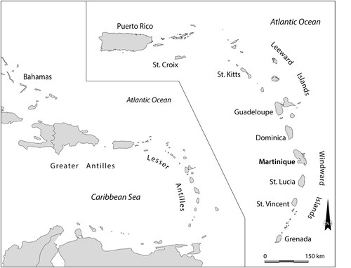
In this article the paleoenvironmental context of the site of Anse Trabaud, southeastern Martinique in the Windward islands of the Lesser Antilles () and the relation to its occupational history is investigated. The site is located on a tombolo connecting a small tied island with the main island of Martinique. This southeastern region, is particularly vulnerable to storm and/or extreme wave events (Hofman and Hoogland Citation2015; Saffache, Marc, and Cospar Citation2002; Schleupner Citation2007, 2008). In 2012 and 2015, archaeological fieldwork was carried out at this site by a team from Leiden University in collaboration with the Service Régional d’Archéologie (SRA) and archaeologist Bérard of the Université des Antilles. The site reflects a continuous habitation during the Late Ceramic Age from 1290 to 780 cal BP and represents two cultural periods, labelled as the Troumassoid and Suazoid series in the region’s chronology (Bérard Citation2019; Petersen, Hofman, and Curet Citation2004; Rouse Citation1992).
Figure 1. Map of the Caribbean. Insert: location of the island of Martinique in the Lesser Antillean island arc divided into the Leeward and Windward Islands (Figure copyright NEXUS1492).
Here a hypothesis is presented as to the paleoenvironmental changes that may have taken place in the site’s area resulting in the deeply buried archaeological artefact yielding horizons (1.60–2.00 m below the current surface) of the earliest occupation of the site (1290–900 cal BP). The archaeological artefacts are found within a 0.4 m thick layer of lagoon mud and the first centimetres of an underlying substrate of carbonate sands. The analyses of the well preserved ceramic, lithic, shell, coral and faunal remains, along with organic materials such as wood, plant macroremains, starch grains and phytoliths, provide a myriad of insights into the ways in which the indigenous inhabitants of the site responded to the erratic climatic conditions, adapted their lifeways, and built resilience to the rapidly changing environment.
Physical Setting of Anse Trabaud
Environment
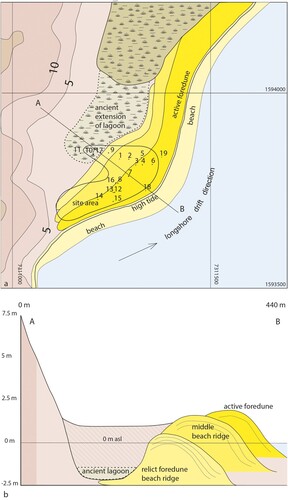
The Anse Trabaud site (UTM 73111250/1593750) is located on the southeastern coastal zone of the Sainte Anne Peninsula in what is currently partly a protected nature area and partly a private property ((a)). Behind the beach, multiple parallel beach ridges of biogenic sand were formed by the onshore transport of shelf sand, with the first ridge being the largest and therefore the active barrier. Sand deposition from longshore drift along the coastline has formed a 900 m long narrow strip of land, or a tombolo (Hume and Herdendorf Citation1988) ((b)). It accreted in a northward and later in an eastward direction, until it eventually connected the tied island Pointe Baham to the main island. This tombolo extends beyond the small peninsula of Morne à Vaches forming a nearly enclosed back barrier environment where once a shallow, muddy lagoon existed in its basin and a fresh or brackish water swamp with mangrove and manchineel cover on the higher parts. During the last 2000 years, a large part of the lagoon has been filled in and only a small lagoon pond still remains, with larger inundated areas during springtide as witnessed during the investigations of 2012 and 2015. The portion of the lagoon east of Morne à Vaches still consists of open water with an outlet in the northwest.
Figure 2. Topographic map of Anse Trabaud, with insert map of Martinique showing the locations of the site areas (Figure by Menno Hoogland).
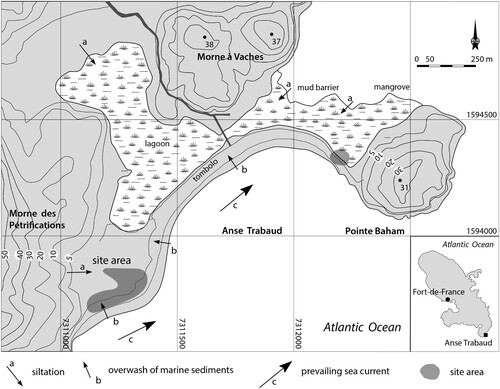
The southwestern part of the lagoon is covered by woodland vegetation. The tombolo is part of a protected littoral forest with large areas occupied by manchineel (Hippomane mancinella). The tombolo is particularly vulnerable to storm events due to its low elevation. The archaeological site of Anse Trabaud lies to the southwest of the tombolo and extends from the beach front of the tombolo to the lagoon basin ().
The following vegetation description is based on a field survey undertaken in 2015. The littoral vegetation at Anse Trabaud is situated on a low sand ridge at the back of the beach and landward across the lagoon basin until a break in slope occurs. The steeper slopes are occupied by xerophytic vegetation, while further inland the undulating terrain at La Baie des Anglais is at present intensively cultivated. In 2015, the vegetation in this coastal area was still recovering from the impact of unrestricted access to the beach by vehicles. Across the lagoon basin there exists a plant association growing in swampy conditions broadly described by Beard (Citation1949) as ‘mangrove woodland’. However, this is an oversimplification because a mosaic of plant associations was discovered during the field survey. A canopy of solely Hippomane macinella trees covers the majority of the site. In a northeasterly direction, the landscape gradually changes to a less densely covered area with low Conocarpus erectus and Avicennia germinans trees separated by areas of exposed fine-grained sediments and dense mats of low, creeping grasses with the herb Blutaparon vermiculare. A shallow brackish lagoon also exists, linked to the sea, which is surrounded by woodland consisting of Avicennia germinans, Laguncularia racemosa and Rhizophora mangle all growing on fine grained sediments ((a)). Where low ridges of sand occurred Conocarpus erectus was predominant.
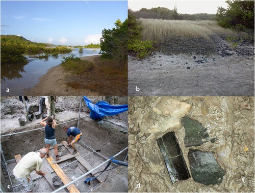
Figure 3. (a) Overview of the seaward shore of the current lagoon with – from left to right – muddy, organic lagoon sediment; loamy sediment resulting from mixing of marine sand and loam; marine sand from tombolo; (b) archaeological material eroding from the beach barrier at the lagoon side of Pointe Baham; (c) excavation of deeply buried archaeological deposits in the lagoon in Unit 17 (2015); and (d) pottery sherds and Aliger gigas shells on the bottom of the lagoon (Photos by Menno Hoogland).
Materials and Methods
Field Methods
The excavation strategy of the 2012 and 2015 field campaigns was geared to the evaluation of the current conditions of the site and to an assessment of the impact of climate challenges on the archaeological record. Earlier investigations at the site during the 1980s and 1990s that had focussed on the area along the coast, estimated the extent of the site to be 1.5 ha between the present shoreline and the old mangrove in the hinterland (Allaire Citation1997, Citation2009; Bérard Citation2013; Mattioni Citation1983). The 2012 and 2015 excavations consisted of a series of 1 × 2 m or 2 × 2 m units in transects along and perpendicular to the coast (see and ). The legal status of the site, as a protected nature area, and the dense canopy limited the use of a theodolite and a differential global positioning system (DGPS). The archaeological units were excavated in arbitrary layers of 10 cm and eco- and artefacts were collected per one m2 units and sifted over a 4 mm mesh. If there was a clear stratigraphic change within an arbitrary layer, the stratigraphy was followed. Features such as postholes and hearths were documented by plan view drawings, photographs and sections. In the mangrove forest a scaffold was built in unit 17 ((c)) to protect the waterlogged sediment layers during excavation and to reinforce the profile walls.
Figure 4. Paleogeomorphology of the site area. (a) Digital elevation model (DEM) constructed from elevation measurements obtained from the locations of excavation units using a Differential Global Positioning System (DGPS); (b) isopach map indicating the measured thickness of surficial loam deposits; and c. cross-section diagram showing the site’s stratigraphy along transect A (Figure by Julijan Vermeer).
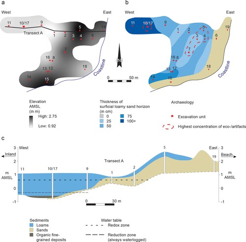
Figure 5. (a) Reconstruction of geomorphology of the site area showing the succession of beach ridges and the ancient extension of the lagoon; and (b) profile A-B showing the buried ancient lagoon and the infill of the depression enclosed by the eastern slope of Morne des Pétrification and a relict beach ridge (Figure by Menno Hoogland).
The profiles of the units were recorded in the field based on observations of colour (using Munsell soil colour chart), texture (using Guidelines for soil description from the Food and Agriculture Organization of the United Nations (Citation2006)), organic matter content, and archaeological material content. During excavation, radiocarbon samples were collected from closed contexts such as refuse layers. Botanical samples came from waterlogged refuse layers or were taken from artefacts in the laboratory.
Eighteen units with a total surface area of 43 m2 were excavated ((a,b)). The excavation units revealed the complexity of the succession of depositions during the nearly 600 years of occupation of the settlement. A detailed reconstruction of the sedimentological processes and the geomorphology was made to understand the relationship between the history of occupation and the dynamics of landscape evolution.
Soils
In the 1960s, the soil and land use of Martinique were mapped by F. Colmet Daage (Citation1969) for the Institut Français de Recherche Scientifique pour le Développement en Coopération (Parry and Perkins Citation2000). The soils of Anse Trabaud were described as grey/blue colored with gleyic patterns reaching the surface (soil map unit Dgg), formed on marine sediments. According to the World Reference Base for Soil Resources 2006 regulations (IUSS Working Group WRB Citation2007), this type of soil is classified as gleysols. The deeper sediments were continuously waterlogged, producing conditions that are known to preserve plant material well (Jacomet Citation2013; Miksicek Citation1987).
Paleogeomorphological Analysis
Geographical coordinate and elevation data of the current surface was obtained for all excavation units with a DGPS. Through interpolation between excavation units, a digital elevation model (DEM) was constructed to reflect the contemporary topography of the archaeological site. Furthermore, profiles of units were recorded to scale and photographed. Although the stratigraphy of the archaeological site is complex, a general sequence of marine sediments was observed in which medium sands found in the lower parts of the profiles are succeeded by loams that lie at the surface. As the site currently has a more or less horizontal elevation, the mapped thickness of the loam deposits was used to reconstruct the past topography and geomorphology of the underlying medium sand deposits. The stratigraphic data obtained from the excavation units in the northern part of the excavated area were used to produce a cross-section diagram providing detailed insight into the subsurface structure of a transect perpendicular to the coastline ().
Radiocarbon Dating
Eleven radiocarbon samples were collected in 2012 and 2015 from closed contexts and submitted for dating to the laboratories of Beta Analytic and the University of Groningen. The conventional BP ages (before present is before 1950) have been calibrated and recalculated to the cal BP time scale using CALIB 8.1.0 (Stuiver, Reimer, and Reimer Citation2021). Calibration is necessary to compare the ages of samples from both the atmospheric and marine reservoirs and to account for the fluctuations in the amount of radioactive carbon in the atmosphere due to cycles of solar activity (Stuiver and Reimer Citation1993; Reimer et al. Citation2013). As marine reservoir corrections show a wide intra- and inter-variability in the Caribbean area following DiNapoli et al. (Citation2021) a ΔR correction of −158 ± 12 years is applied for the calibration of marine samples.
Material Culture Analysis
Large quantities of ceramics, and lithic, shell and coral artefacts have been collected from the various units. The identification of the shell and coral tools was based on previous work on neighbouring islands (Kelly and van Gijn Citation2008; Lammers-Keijsers Citation2005). The stylistic and morphological analyses of the ceramics were undertaken following the Leiden codebook for ceramics (Hofman Citation2005). Lithic analysis was based on a previous study by Bérard (Citation2001) and subsequent work was aimed more at provenance by Knippenberg (Citation2007, Citation2011 and Citation2013), both being based on materials from previous investigations at the site (Bérard Citation2013). Lithic material from the 2012–2015 excavations was documented and briefly described by Walraad (Citation2015) in collaboration with Knippenberg.
Faunal Analysis
Following the zooarchaeological methods described in Reitz and Wing (Citation2008), samples were selected and the derived unit of Minimum Number of Individuals (MNI) and the observational unit of weight were used to analyse the assemblage and conduct a preliminary study of both vertebrate and invertebrate remains. All molluscan nomenclature follows WoRMS (Citation2020) and Tucker and Morris (Citation1995) and habitats were assigned according to Felder and Camp (Citation2009). The faunal analysis was conducted by Philippa Jorissen and corroborated with previous studies on the site’s faunal materials by Grouard (Citation2013) and Serrand (Citation2013).
Archaeobotanical Analysis
Ancient starch grains were extracted from 15 ceramic, coral and stone artefacts from both the Troumassoid and Suazoid contexts following lab procedures published elsewhere (e.g. Pagán-Jiménez Citation2007, Citation2012, Citation2015; Pagán-Jiménez et al. Citation2015). Distinct morphometric characteristics and other surface and tri-dimensional features of starch grains from New World tropical plant species allow identification of plants to genus, species, and sometimes even race or variety level. Ancient starch grain identifications and assessment of modification were based on comparison of morphometric, surface, and optical criteria built on results from previous work on native and modified, archaeological and modern starch grains produced by tubers, rhizomes, corms and seeds from tropical America (e.g. Babot Citation2003; Berman and Pearsall Citation2008; Chandler-Ezell, Pearsall, and Zeidler Citation2006; Mickleburgh and Pagán-Jiménez Citation2012 [Appendix A]; Pagán-Jiménez et al. Citation2017; Perry Citation2004; Piperno Citation2006; Piperno and Holst Citation1998; Ugent, Pozorski, and Pozorski Citation1982, Citation1986). A reference collection containing more than 160 modern specimens from around 90 Neotropical plant species was used in the investigation. Basic statistical analysis of recovered starches is based on the total number of differentiated plant taxa per sample, regardless of the number of individual plants of each taxon that may have been used. By means of ubiquity, i.e. the values of each individual taxon among the analysed samples, the relative importance of some plants over others can be estimated by assuming that the more ubiquitous a taxon is amongst the samples, the more versatile and more frequently it was used in different contexts. The archaeobotanical analysis was carried out by Jaime Pagán Jiménez.
Plant Macroremains Analysis
One face in Unit 10/17 was cleaned and bulk samples were taken to be analysed for plant macroremains. It was decided to work on the bulk sample collected in a 50 × 50 cm square between 168 and 172 cm depth which contained not only many artefacts, but also was observed in the field to yield plant remains. A 200 cm3 subsample was wet sieved through a nest of sieves (the smallest mesh size was 150 μm). All plant macroremains were picked from the residues (see Field and Peglar Citation2010 for details about the plant macroremains analysis). In addition, any large plant macroremains collected from this horizon during the excavation were identified by Michael Field.
Results and Discussion
Preservation Conditions
The archaeological deposits at Anse Trabaud are in situ and the artefacts and botanical remains are extremely well preserved. Behind the sand barrier, sediment profiles are affected by brackish groundwater which resulted in gleyic features, namely (1) a redox zone at depths where the water table fluctuates (0.5–1.5 m), characterised by a mottled pattern of yellowish patches on greyish brown sediment; and (2) a grey coloured reduction zone where sediments are continuously waterlogged (>1.5 m) ((c)).
Excavation Results
The results of the 2012 and 2015 archaeological investigations confirm the extent of the site as was earlier determined by researchers such as Allaire (Citation1997, Citation2009), Bérard (Citation2013), and Mattioni (Citation1983) with the addition that the eastern limit has been determined to be on the shoreline of the ancient lagoon. Intact layers of refuse were encountered on different levels; furthermore, a hearth and postholes were documented next to natural features such as channels. Units 3, 4, 5 and 7 yielded high amounts of eco- and artefacts indicating a more intensive use of that area during the later occupation of the site.
Unit 10/17 in the former mangrove area shows, below the current water table, a complex sequence of muddy lagoon sediments rich in archaeological remains and sterile and thin marine sand layers. These were covered by layers that are scarce in archaeological material being composed of a mixture of overwash marine sand and colluvial loamy sediments, suggestive of high energy event depositions.
Physical and Cultural Contexts
Sedimentological Processes
Sediments representing the strandplain and tombolo were identified as calcareous biogenic medium sands. These white sands originate from the abrasion of the bordering coral reefs (Schleupner Citation2008) and are poorly sorted which is indicative of rapid deposition or a deposition close to its source by either wind or water. Marine sand accumulated by the longshore drift led to the formation of a spit which gradually developed into a tombolo. The continuous aggradation of sand resulted in a progradational sequence of foredunes ((a,b)). Over the centuries, the depressions in this sandy coastal landscape were filled in with sediments from surge related events mixed with colluvial runoff from the adjacent hills and eolian marine sands ((b)). Evidence of past storm surges was found in the form of well documented paleochannels that once drained the back barrier environment, a long sequence of dark grey colored planar laminae (n = 13) representing single flood events, and large blocks of coral that were found in unit 18 close to the beach at depths of 20–40 cm, indicative of high energy events such as cyclones or tsunamis. Gradual changes in depositional processes were driven by Holocene sea level rise and increased erosion from agricultural practices in colonial times.
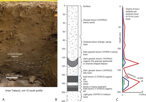
In excavation unit 10/17, a succession of lagoonal, sand and channel deposits at a depth of 1.20–2.00 m was recorded, each stratum representing one or a combination of the abovementioned depositional processes. The majority of these sediments were identified as loams of varying fractions. At the bottom of the former lagoon, on top of a substrate of marine sand, and below the water table, a 0.40 m thick layer of still saturated mud was found that once covered the lagoon’s floor. The loamy mud layer was interrupted by sediment lenses consisting of clay, fine roots, and sand (). From this layer and the first centimetres of the underlying sand the archaeological materials of this study were recovered. The recorded successions of lagoonal deposits reflect this complex dynamic between marine, aeolian and colluvial processes.
Figure 6. (a) Photograph and (b) schematic representation of stratigraphic sequence of the profile of unit 10 with channel shaped feature and lagoonal sediments; and (c). distribution of archaeological materials by weight. (Figure by Julijan Vermeer).
Paleogeomorphology
The thickness of the upper loam deposits was mapped to produce an approximate reconstruction of the topography of the underlying sand deposits ((a,b)). As hydraulic deposits level out near the surface according to the principle of original horizontality (Harris Citation1989, 47), locations of greater thickness were interpreted as depressions in the former landscape, with exception of the strandplain area which was always an elevated feature as indicated by the cross-section diagram of transect A ((c)). The isopach map shows loam deposits of greater thickness (1+ m) at three locations behind the barrier (14, 16, and 10/17). In excavation unit 10/17, an organic-rich deposit of lagoon mud () was recorded. Approximately 0.40 m above the lagoon mud, a U-shaped channel feature was recorded. This feature lies at some 1.2 m below the current surface and is regarded as an infilled paleochannel system collecting runoff water from the surrounding slopes or overwash water from the adjacent beach barrier. Evidence of a second, smaller channel radiocarbon dated to the seventeenth to twentieth centuries was found in unit 8. Its location directly behind the sandy ridge, and its perpendicular orientation to the shoreline, indicate that this channel could also be draining seawater after storm surges.
Chronology
The results of the radiocarbon dating indicate that the site was occupied between 1290 and 760 cal BP (2σ) (), which concurs with the relative ceramic chronology and relates to the Troumassoid and Suazoid series (Hofman Citation2013; Rouse Citation1992). The distribution of the calibrated radiocarbon dates can be related to three events in the formation of the site. A single radiocarbon date (Beta 338018), points to an initial and probably an ephemeral occupation of the site along the lagoon around 1290 cal BP (). The sample consists of an Aliger gigas shell (see http://www.marinespecies.org/aphia.php?p=taxdetails&id=1429769) (previously Strombus and Lobatus gigas) deposited in a layer of mangrove mud at a depth of 1.70–1.90 m below the surface. Three samples (GrA-56012, Beta 551346 and Beta-338017) consist of unidentified seeds, a gourd and an Aliger gigas shell and demonstrate a continuing occupation on the shore of the lagoon between 1000 and 900 cal BP. In this period there is also proof of habitation on the sand barrier close the sea shore. The occupation on the lagoon shore can be divided into two subphases as evidenced by the vertical artefact distribution in units 10 and 17 ((c)). Three more radiocarbon samples point to a continuation of the habitation on the most recent sand barrier and it seems to end around 760 cal BP. At the same time, the lagoon was filled in by colluvial sediments and overwash material. The last set of two radiocarbon dates indicates that a small draining channel encountered in unit 8 was active in the historical period.
Figure 7. Multi-sample probability plot of the calibrated radiocarbon ages (1 σ = black, 2 σ = white) of Anse Trabaud.
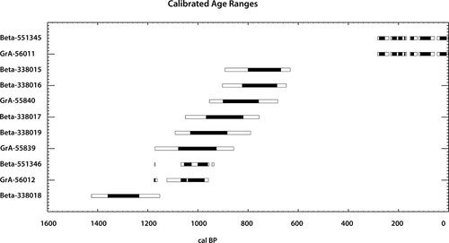
Table 1. Radiocarbon dates of Anse Trabaud and site-specific information (see for location). Radiocarbon ages were calibrated with CALIB 8.1.0 to obtain calibrated years BP (cal BP) (Stuiver, Reimer, and Reimer Citation2021). For the calibration of shell samples (Aliger gigas and Cittarium pica) a ΔR of – 158 ± 12 years (DiNapoli et al. Citation2021) has been applied. Calibration data sets are marine20 (Heaton et al. Citation2020) for shell samples and IntCal20 (Reimer et al. Citation2020) for plant remains. Beta = Beta Analytic, Miami, USA and GrA = Center for Isotope Research, University of Groningen, The Netherlands.
Material Culture
Archaeological remains (ceramic, lithic, shell, coral, faunal and organic) were recovered from the entire basin sequence, with two peaks correlating to two organic-rich horizons. The two horizons presumably reflect a period of occupation coinciding with a relatively high input of organic material leading to soft soils protecting archaeological remains better than in minerogene colluvial sediments. The ceramic material collected in these horizons was completely blackened because of its proximity to the water table and the richness in tannins resulting from mangrove wood degradation. The artefacts were protected from trampling after deposition as evidenced by their large size which allowed stylistic classification.
Based on the ceramic typology, the two occupation phases correspond to the Troumassoid and early Suazoid ceramic series. Both series are common in the Windward Islands of the Lesser Antilles between 1300 and 500 cal BP (Boomert Citation2000; Hofman Citation2013; Keegan and Hofman Citation2017; Rouse Citation1992). The Troumassoid occupation (1290–900 cal BP) is located in the hinterland in the mangrove forest. It probably consisted of some houses built along the shore of the lagoon. During this occupation period, refuse was deposited in mangrove mud and later buried under 1.40–1.80 m of colluvial sediment and overwash material consisting of loam and sand. At the same location, but also on top of the beach barrier, there is evidence of a contemporaneous Troumassoid occupation. On the seaward side of the beach barrier, the Troumassoid occupation is overlaid by an early Suazoid occupation phase (900–780 cal BP).
Ceramics and Shell, Coral and Lithic Artefacts
Ten vessel shapes were documented pertaining to the Troumassoid and Suazoid series. Troumassoid vessels are simple open dishes with orifice diameters between 40 and 60 cm and inward thickened lips covered with a red slip. Early Suazoid pottery includes jars, bowls and dishes with broad line incisions and finger indentations. There is also Calivigny decorated pottery with painted circular motifs in buff and reddish brown colours ((i)), and scratched pottery, as well as tripod vessels, vessel supports, footed griddles and spindle whorls. The assemblage is very similar to those from other sites on Martinique and neighbouring islands (Bullen and Bullen Citation1972).
Figure 8. Troumassoid and Suazoid material culture. (a–c) Lithic flakes of red and yellow jasper; (d) flake of chalcedony; (e) coral tools (Porites porites); (f) axe blade made from St. Martin greenstone; (g) shell adze (Aliger gigas); (h) blackened pottery sherds from mangrove sediment; (i) Calivigny painted pottery vessel; and (j) Suazoid tri-legged cooking vessel (Sala et al. Citation2014; Photos and figure by Menno Hoogland).
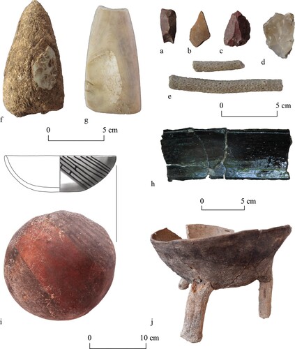
The lithic material consists mainly of artefacts related to the manufacture of flake tools, as shown by a vast number of flakes, cores and other forms of débitage. The occupants of the site used a wide variety of siliceous rocks, including red, yellow and rare green jasper, different varieties of chalcedony, petrified wood and vein quartz (Bérard Citation2001; Knippenberg Citation2007, Citation2011, Citation2013) ((a–d)). These most likely originate from the nearby Savanne des Pétrifications, an extensive area where the majority of these different siliceous rock varieties crop out and can be easily collected. Exploitation of this source location is evidenced by surface scatters of worked material, showing that it also functioned as a workshop site (Bérard Citation2001).
Rare specific siliceous stone varieties, such as green jasper, may have been obtained from elsewhere as this green variety has not been identified at Savane des Pétrifications. It occurs in the Rivière de Simon near la Prairie, 20 km north of the site (Louis Allaire personal communication 2011). However, more easily accessible and more significant outcrops and surface scatters of green jasper can be found at Anse Galet, along the northern coast of the neighbouring island of Saint Lucia (Knippenberg Citation2011). Given the short distance to this southern island and the known maritime expertise of the Indigenous communities inhabiting the region, this source can be considered a likely locality from where the green jasper had been obtained.
The flake tool technology employed can be considered expedient, aimed at the creation of usable sharp edges rather than creating formal tool types. Distinguishing actually utilised flakes from waste flakes is therefore difficult and often needs microscopic techniques. Flakes were likely to have been used in tasks requiring cutting, scraping and coring (see Lammers-Keijsers Citation2008 for examples from Guadeloupe).
Aside from local siliceous stone, most of the magmatic rock (mainly andesite) had probably been obtained from Martinique, or perhaps from nearby northern Saint Lucia. Waterworn pebbles served different tasks, such as hammering, abrading, and polishing (Knippenberg Citation2007). Fine-grained magmatic rock had also been locally worked into axe heads, as is shown by small numbers of débitage, rare pre-forms, and a single finished specimen. The presence of four axe blades made from St. Martin greenstone, a fine-grained tuffaceous mudstone variety originating from this island in the northern Lesser Antilles at a distance of approximately 500 km, testifies to the participation of the Anse Trabaud inhabitants in inter-island exchange networks spanning a large portion of the region (Knippenberg Citation2007, Citation2013) ((f)).
Modified shell implements comprise adzes ((f)), beads of Aliger gigas and shell ornaments or tinklers of Oliva sp. (see also Lammers-Keijsers Citation2008; Serrand Citation2007). Coral fragments (Acropora cervicornis and Porites sp.) have been modified into tools ((e)). From observations made from previous excavations in Guadeloupe, it appeared that the only fragments that were modified before use were those of Porites sp. (Kelly Citation2001; Kelly and van Gijn Citation2008). This species produces relatively hard coral. Sharp edges on the coral were probably used to polish, grind and scrape soft materials. Coral appears to be one of the most used raw materials in the insular Caribbean for the manufacture of tools and ornaments, next to shell and stone (Kelly Citation2001). Recent studies have shown that Acropora palmata tools were used for grinding, abrading and sharpening. This type of coral is relatively flat and covered with coarse pointed and tubular coralites. For artefacts made from Acropora cervicornis, a coral covered with the same type of coralites, it is difficult to distinguish clearly between the traces of use and traces that occur naturally, due to the circular form of the species, and those resulting from natural erosion processes. Several pieces with irregularly eroded edges have been identified. At the archaeological site of Anse à la Gourde on the island of Guadeloupe, similar pieces presented traces of clay and ochre, allowing their use as grinders or scrapers in the pottery manufacturing process to be assumed (Kelly Citation2001).
Human Ecosystem Interactions
Faunal Targeted Species and Procurement Strategies
Twenty-six different families of mollusc were identified, adding up to a total of 6,462 MNI. Overall, the most prominent families were the Donacidae, 37.51% of the total MNI and the Neritidae, 21.12% of the total MNI (). The only taxa collected from the intertidal sandy beach habitat, still prevalent and easily accessible in the current environment, all belong to the family of Donacidae. The intertidal sandy beach habitat was one of the most heavily exploited at Anse Trabaud during the occupation of the site. Remarkably, only 5.56% of molluscs recovered at the site were collected from a mangrove habitat. By contrast, the rocky intertidal zone, from which mainly Neritidae and 10 other taxa were collected, was much more heavily exploited (38.29% of the total MNI). It would have required a higher energy expenditure for the inhabitants from Anse Trabaud to exploit the rocky intertidal areas, since these are located further away than the mangroves and sandy beach intertidal areas.
Table 2. Invertebrate remains identified, Anse Trabaud, Martinique.
In the deeper sediments of the mangrove swamp (>1.60 m), only 14 families were represented with an MNI of 443 (). 44.47% MNI were collected from a rocky intertidal habitat, followed by 22.36% MNI from the mangroves and 15.87% from the sandy beach intertidal habitats. This identifies the rocky intertidal habitat as the most exploited habitat around 1000–900 cal BP. Thus, during the earlier stages of occupation, the diversity of exploited mollusc taxa was less broad than during the later stages. This confirms the findings of previous studies undertaken on the Mattioni/Allaire collection (Serrand Citation2013). Additionally, there was a decline in importance of the mangrove habitat as an exploitation area during the Troumassoid occupation and an increase in importance of the sandy beach habitat during the Suazoid occupation, possibly indicating a disturbance or (partial) destruction of the mangrove area due to natural or anthropogenic impacts at one point in time (Charnov, Orians, and Hyatt Citation1976; Scheffers et al. Citation2009; Reitz and Wing Citation2008).
Table 3. Invertebrate remains identified from unit 10/17 > 160 cm, Anse Trabaud, Martinique.
A comparison with Anse à la Gourde on Guadeloupe revealed that, during the Troumassoid and Suazoid occupation phases, there was a noticeable decrease in exploitation of rocky intertidal species over time (Grouard Citation2001). However, these results are solely based on the analysis of the remains of mainly fish, mammals and crustacea (Grouard Citation2001). Other contemporaneous sites in the Lesser Antilles and on Martinique itself also evidence the increasing importance of bivalves over time (Serrand Citation2013). The Donacidae family has been noted as important in sites on Martinique, but their frequency decreases over time. This is in contrast to the Anse Trabaud data where their frequency increases.
On Anse Trabaud, numerous bones of large mammals and sea turtles were found, as well as smaller remains, most of which are from marine species. The preservation of the bones of the larger taxa is remarkably good, but further analysis of this assemblage is required. Previous studies on the Mattioni/Allaire collection showed the importance of fish species, as well as the exploitation of sea turtles and large marine mammals (Trichechus manatus). Terrestrial animals were also exploited such as Iguana (Iguana sp.), Agouti (Dasyprocta leporina) and rice rat (Megalomys desmarestii) (Grouard Citation2013).
Archaeobotanical Remains
Targeted and Environmental Indicator Taxa
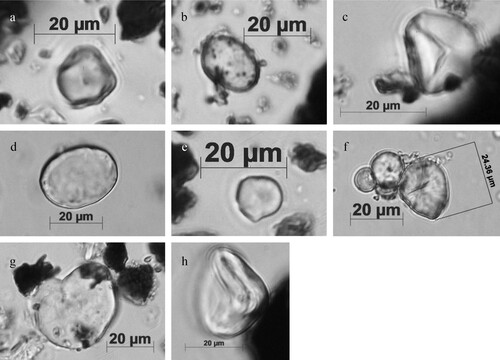
Ancient starch grain results () indicate that maize (Zea mays) starches are one of the more ubiquitous plant remains recovered in the ceramic, coral and stone Troumassoid artefacts from Anse Trabaud. Maize and legume (Fabaceae) starch grains were identified in every ceramic pot and in fewer cases were associated with grains of chili pepper (Capsicum spp.), possibly arrowroot (i.e. approximate or tentative identification as (Maranta arundinacea), cocoyam (Xanthosoma cf. sagittifolium), and manioc (Manihot esculenta C.)) (See (a–h)). One particular cooking pot revealed a single manioc starch grain associated with chili pepper, from which it can be inferred that dishes, such as the ‘pepper pot’ or similar recipes, could have been prepared in this and perhaps other cooking pots. Damage signs on some of the starch grains, recovered in charred crust attached to ceramic pots, suggest that meals were prepared in a cooking environment in which the starchy masses had relatively low humidity, or where masses were cooked at low temperatures for a prolonged period. Coral and stone tools only yielded maize and legume starch grains, indicating that these artefacts were probably used once or twice in the early processing stages of food preparation (grinding and/or grating).
Table 4. Recovered ancient starch grains (identified taxa) by studied artefacts, and notes on other registered microscopic remains (foraminifera, diatoms, phytoliths), Anse Trabaud, Martinique.
During the Suazoid occupation only maize and bean starch grains were identified, both having a similar representation. In this case, maize starch grains were present on two stone tools used for grinding seeds, as well as on various cooking pots and on a clay griddle. Bean starch grains were identified on one of the stone tools, and on various cooking pots, on a clay griddle, and on one ceramic serving vessel. Interestingly, other plants represented during the Troumassoid occupation were absent. The only clay griddle studied, an artefact traditionally related to the production of cassava flatbread, showed the cooking of maize and bean. In this case, starch grains from both taxa are well preserved apart from a small amount showing signs of damage that are consistent with the cooking of masses in a low humidity environment, but over extremely hot and open surfaces (Pagán-Jiménez et al. Citation2017). The identification of manioc in one cooking pot of the earlier occupation of the site suggests that other ways of processing and cooking cassava were employed, while the preparation of cassava flatbread in clay griddles was, perhaps, uncommon during both occupation episodes at this site.
The plant macroremains results also show that some benefits and challenges were presented to the occupants by the nature of the habitat they lived in and show a clear shift from the Troumassoid to Suazoid occupations. Troumassoid artefacts resting in the wet layers in the mangrove swamp reflect a wider spectrum of used starchy plants (maize, bean, manioc, arrowroot, cocoyam) when compared with Suazoid artefacts from the upper layers (only maize and bean) which reflect a narrower selection of important starchy plants. This certainly contrasts with other contemporary Toumassoid-Suazoid sites of the region like Lavoutte on Saint Lucia and Anse à la Gourde on Guadeloupe which, although located in a very similar physical setting and taking part in the same network of mobility and exchange of goods, reflect a broader access or selection of starchy plants all the way through. Ancient starch grain studies were previously undertaken on human dental calculus samples from Lavoutte and Anse à la Gourde (see Mickleburgh and Pagán-Jiménez Citation2012; Pagán-Jiménez and Mickleburgh Citation2015). However, these studies revealed a different spectrum of food plant derivatives being masticated by ancient peoples. In Lavoutte, the Suazoid community seems to have been consuming maize and manioc almost in a similar proportion, while plants such as beans appear to have played a minor role in the overall diet. In the same way, starch grains retrieved from the teeth of individuals from Lavoutte and Anse à la Gourde have suggested that maize was the most ubiquitous food plant consumed by these people in addition to marunguey (Zamia spp.), a wild gymnosperm plant and one of the few surviving primitive species of the family Zamiaceae. Other plants were consumed including manioc, bean, arrowroot, but it seems they comprised a less important role in the diet.
Wood, macroremains and microscopic remains were recovered from waterlogged sediment layers in units 10 and 17 (). However, these remains are not exclusively related to artefact use, but rather to the environmental conditions at the time of sediment deposition. This is the case of benthic foraminifera, diatoms and phytoliths registered in the same sediment samples submitted to starch grain analysis. These remains were incidentally extracted with procedures not specifically designed for retrieving them. Benthic foraminifera were recovered in artefact samples located within and above the waterlogged and muddy organic-rich horizon, while diatoms (cf. Nupela spp. and some unidentified taxa) only occurred in samples recovered within the waterlogged/muddy horizon. Many diatom species develop in freshwater and brackish environments, but also in subaerial terrestrial habitats (Antonelli et al. Citation2017; Stanek-Tarkowska et al. Citation2018). However, most Nupela species known for the lowland Neotropics (Sala et al. Citation2014) are strictly associated with freshwater environments, thus suggesting that the waterlogged sediments where the artefacts were recovered could have been developed in a freshwater environment.
Figure 9. Ancient starch grains recovered in Troumassoid tools. (a) Zea mays ATR-10, cooking pot; (b) Maranta sp. (ATR-16, cooking pot); (c) Manihot esculenta (ATR-15, cooking pot); (d) Capsicum sp. (ATR-15, cooking pot); (e) Xanthosoma cf. sagittifolium (ATR-10, cooking pot); (f) cluster of Zea mays (ATR-01, clay griddle); (g) cf. Phaseolus sp. (ATR-07, cooking pot); and (h) unidentified, twisted starch due to partially dry heat (ATR-11, serving bowl) (Photos by Jaime Pagán-Jiménez).
Wood and grass phytoliths, mostly associated with moist/wet environments (e.g. bulliforms, polylobates and prickle-type hair cells) were identified in artefact samples that came from the waterlogged muddy horizon. Additionally, echinate phytoliths produced in the fruit seed coats and leaves of palms were registered in artefact samples from the muddy horizon. It is known that some native palm species such as Roystonea sp. and Aiphanes spp. grow well on moist substrate or close to permanently waterlogged areas. Recovered globular echinates could not be assigned to any taxa due to the lack of specific diagnostic traits that characterise the phytoliths produced within the Arecaceae family (Huisman, Raczka, and McMichael Citation2018). However, it is interesting to know that in the Antilles, plants from this family have historically been sources of raw material for basketry, floor boards and roofing thatch. Fruits, seeds and fresh palmito have been used as human food because of the sugar content of the young leaflets, while the flowers and the fruit mesocarp could be directly eaten or used for preparing fermented beverages (James Citation2009).
The plant macroremains analyses yielded well preserved material from a small number of taxa. Harsh depositional conditions in the tropics, including oxidation and microbial attack, mean that good preservation of plant macroremains is rare (Pagán-Jiménez Citation2007; Pearsall Citation2016). The sediments investigated from the mangrove unit were in the reduction zone and probably had been continuously below the water table, since sediment deposition allowed for good plant macroremains preservation. Potentially rapid sediment accumulation may also have contributed to the excellent preservation.
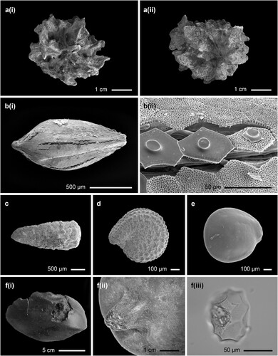
Today, the sampling locality of the unit 10/17 bulk sample is below a Hippomane macinella canopy. At this location few other plant species were recorded in the modern vegetation. Many decayed fruits of Hippomane macinella were found in the sediments collected from unit 10/17 ((a) (i) and (ii)). This suggests that vegetation had not changed greatly with trees of Hippomane macinella existing at the site for long periods. This euphorbiaceous species would have presented challenges for the resident population because it contains toxic substances. The species was used by the pre-colonial indigenous peoples (Carib or Kalinago of the Lesser Antilles) for poisoning their arrows, with arrowroot (Maranta arundinacea) applied as the antidote (Hodge and Taylor Citation1957). According to the French missionary Breton (Citation1665) balaóboucourou is the Kalinago name for the tree, and tiboúcoulou bouléoüa is the latex extracted from the tree for poisoning arrows. Today, the tree is officially considered the most lethal tree in the world. To live under its canopy could have been a challenge. However, its timber has been exploited by Caribbean carpenters for centuries and the trees may have been perceived to be a useful natural resource. In addition, the trees offer shelter from the wind and the root system promotes the stabilisation of the beach, thus reducing coastal erosion. Other components in the plant macroremains assemblage from unit 10/17 show that, although there are similarities between the composition of the assemblage and modern vegetation, some differences do occur.
Figure 10. Benthic foraminifera, diatoms and phytoliths from the deeply buried deposits in the mangrove forest. (a,b) benthic foraminifera (ATR-01, clay griddle); (c,d) diatoms (ATR-16 [cooking pot] and ATR −26 [coral tool], respectively); (e,f) Arecaceae phytoliths, globular echinates (ATR-01 [clay griddle] and ATR-28 [stone tool], respectively); and g. grass buliform phytolith (ATR-26, coral tool) (Photos by Jaime Pagán Jiménez).
![Figure 10. Benthic foraminifera, diatoms and phytoliths from the deeply buried deposits in the mangrove forest. (a,b) benthic foraminifera (ATR-01, clay griddle); (c,d) diatoms (ATR-16 [cooking pot] and ATR −26 [coral tool], respectively); (e,f) Arecaceae phytoliths, globular echinates (ATR-01 [clay griddle] and ATR-28 [stone tool], respectively); and g. grass buliform phytolith (ATR-26, coral tool) (Photos by Jaime Pagán Jiménez).](/cms/asset/8b9599bc-42a5-49fd-88eb-121a0226a5fe/yenv_a_1921676_f0010_ob.jpg)
The large number of Cyperaceae seeds ((b)) represented in the plant macroremains assemblage may point to fresh water, possibly in a channel, near the site at the time of pre-European occupation. During the 2015 field survey, no channels were observed in the basin. Their absence may indicate that the drainage system of the basin may have changed since occupation. Also of interest are the records of Eclipta prostrata L. ((c)) and Portulaca oleracea L. ((d)) which occur today in warm temperate and tropical areas worldwide. These ruderal plants may have been expected to have been widely transported around the world by humans since the sixteenth century. However, many studies have shown that they were present in North and Central America and also in the Caribbean prior to the arrival of Europeans (see Newsom and Wing Citation2004; Pagán-Jiménez Citation2007). Their occurrence indicates open, moist areas in or around the site at the time of pre-European occupation. The presence of Chenopodiaceae seeds possibly indicates disturbed areas existed around the settlement ((e)).
Several fragments of a large fruit were recovered during the excavation (from FND 348, unit 10B, layer 17 on the 7/7/2012) that provide insight into one plant that the Anse Trabaud community was exploiting at the time of sediment deposition. The morphology of the fruit, particularly its stalk attachment ((f) (i) and f (ii)), suggests that it belongs to the Cucurbitaceae (Squash) family. Phytoliths extracted from parts of the preserved lignified rind were of a morphotype that supports this determination ((f) (iii)). Hemispherical and elongated scalloped phytoliths that closely resemble the characteristic phytoliths of the Cucurbitaceae family were recovered (Bozarth Citation1987; Piperno Citation2009; Piperno et al. Citation2002). The phytoliths do not match those produced by domestic squashes such as Cucurbita pepo and C. maxima. Scalloped impressions produced in the surface of the recovered phytoliths are irregular and mostly elongated, and the maximum size range for 17 of these phytoliths is from 63.41 to 112.21 µm (mean is 78.52 ± 12.41 µm). These morphometric characteristics suggest that these phytoliths developed in contact with irregular stone cells loosely organised in the interface of the hypodermis and upper mesocarp of the lignified rind (Piperno et al. Citation2002). Only bottle-gourd (Lagenaria siceraria) and some domestic C. moschata varieties are known to produce hemispherical to elongated phytoliths with these particular stone cell impressed concavities ().
Figure 11. Plant remains from unit 10/17 at Anse Trabaud: a. (i) and a. (ii) – a decayed Hippomane macinella fruit; b. (i) a Cyperaceae seed and b. (ii) the epidermal cells close-up; c. a seed of Eclipta prostrata, d. – a seed of Portulaca oleracea, e. – a Chenopodiaceae seed, f. (i) the fruit that may belong to the Cucurbitaceae family the Squash family, f.(ii) – the stalk of the fruit (Photos by Michael Field), and f. (iii) – a phytolith extracted from the fruit (Photos by Jaime Pagán-Jiménez).
Conclusions
Southeastern Martinique is much exposed to oceanic impacts, and storms and extreme wave events that may have been potentially harmful for the continuous pre-colonial occupation of Anse Trabaud. The lithological sequences suggest that the dry sandy beach surface where coarse grained sands and coral debris are deposited by wave action and winds is juxtaposed with a lagoon where dark grey, organic rich silts and clays are deposited in shallow water. The relict beach barriers are covered by substantial deposits of loamy sands resulting from overwash events. The former lagoon is partly covered by the same sediments, partly by colluvial sediment. At the time of the early occupation on the shore of the lagoon, it was a freshwater body as evidenced by Nupela like diatoms and cyperaceous seeds. Foraminifera recovered in samples from these same artefacts throughout the vertical sediment sequence (wet, but also upper layers), indicate that pedogenesis was notably influenced by the influx of marine detritus. So, the tombolo is dynamic in time as high energy storm events causing erosion and elsewhere sand suppletion, triggered re-organisation of sand barriers, water currents and the mosaic of vegetation cover, including site-specific changes from an open beach setting into a closed manchineel and mangrove forest. Climate change, seasonal rainfall fluctuations, storm surge regime, gradual sea level rise, agricultural practices and a sediment stabilising mangrove forest have impacted the sedimentation process in the lagoon.
The excellent state of conservation of the deeply buried deposits with well-preserved inorganic and organic remains at the site of Anse Trabaud, are exceptional factors that have facilitated a better understanding of how the inhabitants of this region responded to the dynamic coastal environment in which they lived. The sediment sequences in mangrove swamps possess a significant heritage value because wood and other perishable materials are well preserved. The deposits evidence an early occupation of 1290–900 cal BP, located along the shore of a lagoon overlain by a mangrove and manchineel forest. The earliest settlement probably consisted of houses built on the higher parts of a sandy shoreline of the lagoon.
In the wider region, the period of 1150–950 cal BP has shown to have been a time with prolonged droughts (Hodell et al. Citation2001; Haug et al. Citation2003). Wetter conditions prevailed again after cal BP 950 and, despite the climatic challenges and the vulnerability of the settlement location, later communities at Anse Trabaud seem to have adapted to the gradually rising sea level by moving the settlement to the outer and higher beach barriers near the shore. In terms of setting, settlement and procurement strategies the site of Anse Trabaud shares many similarities with other settlements in the southern part of Martinique, as well as with sites on the neighbouring islands of Saint Lucia and Guadeloupe.
The natural C4 vegetation surrounding the site was subsequently replaced by cultivated C3 plants. The setting of Anse Trabaud in both the landscape and seascape is central to an understanding of the dynamics of the occupants of the site in terms of subsistence and procurement strategies. Situated on a dune between mangroves and salt ponds to the west and the wild Atlantic to the east, inhabitants were able to exploit a range of marine and terrestrial resources. Abundant turtle bones and shellfish in the archaeological deposits attest to this exploitation. Over time the exploitation of rocky intertidal species notably decreased similar to what is seen in neighbouring sites. On the contrary plant procurement and consumption, shows a decrease in species during the course of occupation contrary to what is observed in contemporary sites in the region. The technological exploitation of the immediate environment of the Anse Trabaud site is illustrated by the use of materials such as corals, shells, calcedoine and jasper found in abundance. These materials have been widely used in the raw state as well as for the manufacture of tools and the making of ornaments. On the other hand, other raw materials, such as flints native to Antigua and radiolarites from St. Martin (for the manufacture of axes) confirm contacts with communities on surrounding islands. The adaptations in settlement organisation and environmental and procurement strategies at Anse Trabaud reflect the participation of this indigenous community in the regional social networks of the Lesser Antilles. These networks were anchored in human mobility and the exchange of goods, knowledge and ideas and which probably served as a safety net in times of harshness and climatic challenges at the advent of European arrival in the Caribbean.
Acknowledgements
We thank the Service Régional de l’Archéologie of Martinique for setting up a collaboration with Leiden University for the archaeological investigations at Anse Trabaud. We acknowledge the Office National des Forest (ONF) and the Bellassée family landowner of parts of the site for granting us permission to excavate on his property. We are very grateful to all field school participants, students from Leiden and the Université des Antilles, and local volunteers, for their hard work. We thank Emma de Mooij for her editorial help and David and Gregory Tonnks for their editing of the original English text. We thank Scott Fitzpatrick for his suggestions for the calibration of the C14 dates. This work is part of the research programme Island Networks: modelling inter-community social relationships in the Lesser Antilles across the historical divide (2013–2018).
Disclosure Statement
No potential conflict of interest was reported by the author(s).
Additional information
Funding
Notes on contributors
Corinne L. Hofman
Corinne L. Hofman is Professor of Caribbean Archaeology at the Faculty of Archaeology, Leiden University, The Netherlands, and Principal Investigator of the CaribTRAILS project at the Royal Netherlands Institute of Southeast Asian and Caribbean Studies (KITLV/KNAW). Hofman has conducted fieldwork throughout the Caribbean over the past 30 years (together with Menno Hoogland). Her research and publications are highly multi-disciplinary and major themes of interest center around mobility and exchange, colonial encounters, inter-cultural dynamics, settlement archaeology, artifact analyses, and provenance studies. Hofman’s projects are designed to contribute to the historical awareness, valorisation of archaeological heritage, and knowledge exchange in the Caribbean. Hofman has obtained numerous research grants and prizes, including the NWO Spinoza price and the ERC-Synergy Grant for the NEXUS1492 project.
Jaime R. Pagán-Jiménez
Jaime R. Pagán-Jiménez (Doctorate in Anthropology, Universidad Nacional Autónoma de México, 2005) is research director and senior paleoethnobotanists at Cultural Heritage & Plantscape Research (Leiden, The Netherlands). His current research examines the paleoethnobotany of the Caribbean islands and also of French Guiana and Ecuador in South America. Concomitantly, he studies the sociopolitics of the archaeological praxis in the Caribbean and Latin America.
Michael H. Field
Michael H. Field is Associate Professor in Archaeobotany at the Faculty of Archaeology, Leiden University. Field completed a BSc(Hons) degree and then a PhD investigating the taphonomy of plant macrofossils, followed by four Post Doc posts (Botany, Cambridge; Geosciences, Leipzig; Botanical History and Palynology, Marseille; Quaternary Science, Coventry) before taking up a position at Leiden. Apart from his interest in European vegetation history and the reconstruction of Pleistocene environments he is also a keen field botanist. Often as part of a multidisciplinary team he contributed to the understanding of western European Early, Middle and Late Pleistocene landscapes in which early hominids lived and evolved. He received funding from the British Government to investigate the response of the vegetation to the volcanic eruption on the Caribbean island of Montserrat and during the past decade he has also participated as an archaeobotanist in several field campaigns on Curacao, Saint Lucia and the Dominican Republic.
Henry Hooghiemstra
Henry Hooghiemstra is a paleoecologist who studied climate change in different ecosystems on long (last million years) to short (Holocene to Anthropocene) time scales. Relationships between climate and civilisations has his special interest.
Julijan A.M. Vermeer
Julijan J.A.M. Vermeer (MA, Ghent University) currently works as a soil planner and archaeological supervisor for an engineering firm in Leipzig, Germany. Before that he was part of the Caribbean Research Group of Leiden University. He has specialised in geoarchaeology with a focus on paleotopography, coastal geomorphology and archaeological site formation. Through his research he has helped archaeologists better understand the ancient physical and cultural landscapes of Europe and the Caribbean. Most of his work is directed toward the integration of archaeological stratigraphy into Caribbean archaeology.
Philippa Jorissen
Philippa Jorissen (MA, Leiden University) is a PhD student at the University of Oregon. Her research interests include human-ecodynamics, GIS, zooarchaeology, and island and coastal archaeology. Her dissertation is focused on the resilience of inhabitants in three different locations across the Caribbean and Micronesia, with a special focus on the interactions between humans and marine environments. She is also interested in the synergy between archaeology and ecology and its potential to address modern day conservation issues.
Sebastiaan Knippenberg
Sebastiaan Knippenberg holds a PhD in Caribbean Archaeology obtained at Leiden University in 2006. He currently works at Archol BV, the contract archaeological firm affiliated with Leiden University. His main research interests relate to stone material sourcing, raw material procurement, lithic tool production and distribution within the Caribbean archipelago, as well as to the study of the underlying exchange systems and social networks. His other research focus is on Dutch Archaeology, particularly on Neolithic and Bronze Age settlement systems in addition to the study of local lithic procurement, technology and use. He has supervised numerous excavation projects in the Caribbean and the Netherlands.
Benoît Bérard
Benoît Bérard is full professor at the Université des Antilles where he serves as director of the AIHP-GEODE Caribbean research group. He has directed numerous excavations of pre-Columbian archaeological sites. He has also coordinated international research programmes in various islands of the Lesser Antilles. He has directed, co-directed and authored various books as well as more than 80 chapters of books and scientific articles on Caribbean Amerindian civilisations and the protection and integration of Amerindian legacies in the heritage of contemporaneous Caribbean Creole societies.
Menno L.P. Hoogland
Menno L.P. Hoogland is a retired Associate Professor in the Faculty of Archaeology at Leiden University. Hoogland wrote his PhD thesis on settlement patterns of the Amerindian population of Saba, Caribbean Netherlands and is specialised in the archaeology of the Caribbean. He is an expert in archaeothanatology and funerary practices of pre-colonial and early colonial Amerindian societies in the Caribbean. Hoogland directed or participated in many archaeological investigations in Cuba, Dominican Republic, on most of the Lesser Antillean islands, and the islands in the Kingdom of the Netherlands. He was a senior researcher in the ERC-Synergy project ‘Nexus 1492’ directed by Corinne L. Hofman of Leiden University. Currently he is senior researcher in the project CaribTrails directed by Hofman at the Royal Netherlands Institute of Southeast Asian and Caribbean Studies (KITLV/KNAW).
References
- Allaire, L. 1997. Anse Trabaud: Rapport 1997. In Le néolithique de la Martinique dans son contexte antillais, edited by J.P. Giraud. (Projet collectif de recherche) SRA Fort de France, Martinique.
- Allaire, L. 2009. Anse Trabaud 1983-1984. Rapport sur le mobilier céramique. Unpublished report.
- Antonelli, M., C. E. Wetzel, L. E. Ector, A. J. Teuling, and L. Pfister. 2017. “On the Potential for Terrestrial Diatom Communities and Diatom Indices to Identify Anthropic Disturbance in Soils.” Ecological Indicators 75: 73–81.
- Babot, M. del P. 2003. “Starch Grain Damage as an Indicator of Food Processing.” In Phytolith and Starch Research in the Australian-Pacific-Asian Regions: The State of the Art. Papers from a conference held at the ANU August 2001, Canberra, Australia, edited by D. M. Hart and L. Y. Wallis, 69–81. Canberra: Pandanus Books.
- Beard, J. S. 1949. The Natural Vegetation of the Windward and Leeward Islands. Oxford Forestry Memoirs Vol. 21. Wotton-under-Edge: Clarendon Press.
- Beets, C. J., S. R. Troelstra, P. M. Grootes, M.-J. Nadeau, K. van der Borg, A. F. M. de Jong, C. L. Hofman, and M. L. P. Hoogland. 2006. “Climate and pre-Columbian Settlement at Anse à la Gourde, Guadeloupe, Northeastern Caribbean.” Geoarchaeology: An International Journal 21 (3): 271–280.
- Bérard, B. 2001. Gestion de materias primas silicosas y organizacion del territorio de los Amerindios de Martinica. In Actas del seminario regional “culturas aborigenes del Caribe”, Santo Domingo, 12 et 13 novembre 1998, 267–278. Santo Domingo, FISS.
- Bérard, B. 2013. Martinique, terre Amérindienne, une approche pluridisciplinaire. Leiden: Sidestone Press.
- Bérard, B. 2019. “About Boxes and Labels: A Periodization of the Amerindian Occupation of the West Indies.” Journal of Caribbean Archaeology 19: 51–67.
- Berman, M. J., and D. M. Pearsall. 2008. “At the Crossroads: Starch Grain and Phytolith Analysis in Lucayan Prehistory.” Latin American Antiquity 19 (2): 181–203.
- Boomert, A. 2000. Trinidad, Tobago, and the Lower Orinoco Interaction Sphere: An Archaeological/Ethnohistorical Study. Alkmaar: Cairi Publications.
- Bozarth, S. R. 1987. “Diagnostic Opal Phytoliths from Rinds of Selected Curcubita Species.” American Antiquity 52: 607–615.
- Breton, R. 1665. Dictionnaire caraïbe-français. Auxerre: Gilles Bouquet.
- Bullen, R. P., and A. K. Bullen. 1972. Archaeological investigations on St. Vincent and the Grenadines, West Indies. The William L. Bryant Foundation, American Studies No. 8.
- Carson, M. T. 2011. “Palaeohabitat of First Settlement Sites 1500-1000 B.C. in Guam, Mariana Islands, Western Pacific.” Journal of Archaeological Science 38 (9): 2207–2221.
- Chandler-Ezell, K., D. M. Pearsall, and J. A. Zeidler. 2006. “Root and Tuber Phytoliths and Starch Grains Document Manioc (Manihot Esculenta), Arrowroot (Maranta Arundinacea), and Llerén (Calathea sp.) at the Real Alto Site, Ecuador.” Economic Botany 60 (2): 103–120.
- Charnov, E. L., G. H. Orians, and K. Hyatt. 1976. “Ecological Implications of Resource Depression.” American Naturalist 110: 247–259.
- Chenoweth, M., and D. Divine. 2008. “A Document-Based 318-Year Record of Tropical Cyclones in the Lesser Antilles, 1690-2007.” Geochemistry, Geophysics, Geosystems 9 (8): 1–21. doi:10.1029/2008GC002066.
- Chenoweth, M., and D. Divine. 2012. “Tropical Cyclones in the Lesser Antilles: Descriptive Statistics and Historical Variability in Cyclone Energy, 1638–2009.” Climate Change 113 (3/4): 583–598.
- Colmet Daage, M. F. 1969. Carte des sols des Antilles à 1:20.000, Guadeloupe-Martinique. Office de la recherche scientifique et technique outre-mer (OSTROM), Centre des Antilles Bureau des Sols.
- Cooper, J. 2012. “Fail to Prepare Then Prepare to Fail: Rethinking Threat Vulnerability and Mitigation in the pre-Columbian Caribbean.” In Surviving Sudden Environmental Change: Answers from Archaeology, edited by J. Cooper, and P. Sheets, 91–114. Boulder: University of Colorado Press.
- Cooper, J., and M. Peros. 2010. “The Archaeology of Climate Change in the Caribbean.” Journal of Archaeological Science 37 (6): 1226–1232.
- Crock, J. G., and J. B. Peterson. 1999. “A Long and Rich Cultural Heritage: The Anguilla Archaeology Project, 1992–1998.” Report prepared for the Anguilla Archaeological and Historical Society, The Valley, Anguilla British West Indies.
- Curtis, J. H., M. Brenner, and D. A. Hodell. 2001. “Climate Change in the Circum-Caribbean (Late Pleistocene to Present) and Implications for Regional Biogeography.” In Biogeography of the West Indies: Patterns and Perspectives, 2nd ed., edited by C. A. Woods, and F. E. Sergile, 35–54. Boca Raton: CRC Press.
- Curtis, J. H., and D. A. Hodell. 1993. “An Isotopic and Trace Element Study of Ostracods from Lake Miragoane, Haiti: A 10,500 Year Record of Paleosalinity and Paleotemperature Changes in the Caribbean.” Washington DC American Geophysical Union Geophysical Monograph Series 78: 135–152.
- Delpuech, A. 2004. “Espaces naturels et territoires amérindiens dans la Caraibe orientale.” In Late Ceramic Age Societies in the Eastern Caribbean, edited by A. Delpuech and C. L. Hofman, 4–17. Paris Monographs in American Archaeology 14, BAR International Series 1273. Oxford: Archaeopress.
- DiNapoli, R. J., S. M. Fitzpatrick, M. F. Napolitano, T. C. Rick, J. H. Stone, and N. P. Jew. 2021. “Marine Reservoir Corrections for the Caribbean Demonstrate High Intra- and Inter-Island Variability in Local Reservoir Offsets.” Quaternary Geochronology 61: 1–21.
- Douglas, P. M. J., M. Brenner, and J. H. Curtis. 2016. “Methods and Future Directions for Paleoclimatology in the Maya Lowlands.” Global and Planetary Change 138: 3–24.
- Douglas, K., and J. Cooper. 2020. “Archaeology, Environmental Justice, and Climate Change on Islands of the Caribbean and Southwestern Indian Ocean.” Proceedings of the National Academy of Science of the United States of America 117 (5): 8254–8262.
- Felder, D. L., and D. K. Camp, eds. 2009. Gulf of Mexico origin, waters, and biota: Volume 1, biodiversity. Corpus Christi: Texas A&M University Press.
- Field, M. H., and S. M. Peglar. 2010. “A Palaeobotanical Investigation of the Sediments from the West Runton Mammoth Site.” Quaternary International 228: 38–45.
- Fitzpatrick, S. M., and W. F. Keegan. 2007. “Human Impacts and Adaptations in the Caribbean Islands: An Historical Ecology Approach.” Earth and Environmental Science Transactions of the Royal Society of Edinburgh 98 (1): 29–45.
- Flantua, S. G. A., H. Hooghiemstra, M. Vuille, H. Behling, J. F. Carson, W. D. Gosling, I. Hoyos, et al. 2016. “Climate Variability and Human Impact in South America During the Last 2000 Years: Synthesis and Perspectives from Pollen Records.” Climate of the Past 12: 483–523. doi:10.5194/cp-12-483-2016.
- Food and Agriculture Organization of the United Nations (FAO). 2006. Guidelines for Soil Description, Fourth Editon. Rome: FAO.
- Grouard, S. 2001. “Faunal Remains Associated with Late Saladoid and Post-Saladoid Occupations at Anse à la Gourde, Guadeloupe, West Indies: Preliminary Results.” Archaeofauna 10: 71–98.
- Grouard, S. 2013. “Chasses, pêches et captures des faunes vertébrées et crustacées des occupations côtieres céramiques récentes du sud de la Martinique (Saladoïde, Ve siècle ap. J.-C.–Suazoïde, XVe siècle ap. JC).” In Martinique terre amérindiennes: une approche pluridisciplinaire, edited by B. Bérard, 115–163. Leiden: Sidestone Press.
- Harris, E. C. 1989. Principles of Archaoelogical Stratigraphy. 2nd ed. San Diego, CA: Academic Press.
- Haug, G. H., D. Gunther, L. C. Peterson, D. M. Sigman, K. A. Hughen, and B. Aeschlimann. 2003. “Climate and the Collapse of Maya Civilization.” Science 299 (5613): 1731–1735.
- Haviser, J. B. 2019. “Archaoelogical Evidence and the Potential Effects of Paleotsunami Events During the Archaic Age in the Southern Caribbean.” In Early Settlers of the Insular Caribbean: Dearchaizing the Archaic, edited by C. L. Hofman, and A. T. Antczak, 57–64. Leiden: Sidestone Press.
- Heaton, T. J., P. Köhler, M. Butzin, E. Bard, R. W. Reimer, W. E. N. Austin, Chr. Bronk Ramsey, et al. 2020. “Marine20—the Marine Radiocarbon age Calibration Curve (0–55,000 cal BP).” Radiocarbon 62 (4): 779–820.
- Higuera-Gundy, A., M. Brenner, D. A. Hodell, J. H. Curtis, B. W. Leyden, and M. W. Binford. 1999. “A 10,300 14C Yr Record of Climate and Vegetation Change from Haiti.” Quaternary Research 52 (2): 159–170.
- Hodell, D. A., M. Brenner, J. H. Curtis, and T. Guilderson. 2001. “Solar Forcing of Drought Frequency in the Maya Lowlands.” Science 292 (5520): 1367–1370.
- Hodell, D. A., J. H. Curtis, G. A. Jones, A. Higuera-Gundy, M. Brenner, M. W. Binford, and K. T. Dorsey. 1991. “Reconstruction of Caribbean Climate Change Over the Past 10,500 Years.” Nature 352: 790–793.
- Hodge, W. S., and D. Taylor. 1957. “Ethnobotany of the Island Caribs of Dominica.” Webbia 12 (2): 513–644.
- Hofman, C. L. 2005. “Codebook for Ceramics.” Leiden University, https://www.potbuilder.net/.
- Hofman, C. L. 2013. Anse Trabaud commune de Sainte-Anne, Martinique: reconstruction d’un village amérindien. Son insertion dans le réseau d’échanges Antillais entre 600 et 1200 après J.-C. Rapport de fouille programmée, Leiden/ Direction Régionale des Affaires Culturelles.
- Hofman, C. L., and A. T. Antczak, eds., 2019. Early Settlers of the Insular Caribbean: Dearchaizing the Archaic. Leiden: Sidestone Press.
- Hofman, C. L., and M. L. P. Hoogland, eds., 1999. Archaeological investigations on St. Martin (Lesser Antilles): The sites of Norman Estate, Anse des Pères and Hope Estate with a contribution to the ‘La Hueca problem’. Archaeological Studies Leiden University 4. Leiden University.
- Hofman, C. L., and M. L. P. Hoogland. 2015. “Beautiful Tropical Islands in the Caribbean Sea. Human Responses to Floods and Droughts and the Indigenous Archaeological Heritage of the Caribbean.” In Water and Heritage: Material, Conceptual and Spiritual Connections, edited by W. J. H. Willems, and H. Schaik, 99–119. Leiden: Sidestone Press.
- Hofman, C. L., A. A. A. Mol, M. L. P. Hoogland, and R. Valcárcel Rojas. 2014. “Stage of Encounters: Migration, Mobility and Interaction in the pre-Colonial and Early Colonial Caribbean.” World Archaeology 46 (4): 590–609.
- Huisman, S. N., M. F. Raczka, and C. N. McMichael. 2018. “Palm Phytoliths of mid-Elevation Andean Forests.” Frontiers in Ecology and Evolution 6: 1–8. doi:10.3389/fevo.2018.00193.
- Hume, T. M., and C. E. Herdendorf. 1988. “A Geomorphic Classification of Estuaries and its Application to Coastal Resource Management—a New Zealand Example.” Ocean and Shoreline Management 11 (3): 249–274.
- IUSS Working Group WRB. 2007. “World Reference Base for Soil Resources 2006, first update 2007.” World Soil Resources Reports No. 103. FAO, Rome.
- Jacomet, S. 2013. “Archaeobotany: Analysis of Plant Remains from Waterlogged Archaeological Sites.” In The Oxford Handbook of Wetland Archaeology, edited by F. Menotti and A. O’Sullivan, 497–514.
- James, A. 2009. “Notes on the Uses of Dominica’s Native Palms.” Palms 53 (2): 61–67.
- Keegan, W. F., and C. L. Hofman. 2017. The Caribbean Before Columbus. New York: Oxford University Press.
- Kelly, H. 2001. “Coral tools from the site of Anse à la Gourde.” MA thesis, Leiden University, Leiden.
- Kelly, H., and A. van Gijn. 2008. “Understanding the Function of Coral Tools from Anse à la Gourde: An Experimental Approach.” In Crossing the Borders: New Methods and Techniques in the Study of Archaeological Materials from the Caribbeaņ, edited by C. L. Hofman, M. L. P. Hoogland, and A. van Gijn, 115–124. Tuscaloosa: University of Alabama Press.
- Khan, N. S., E. Ashe, B. P. Horton, A. Dutton, R. E. Kopp, G. Brocard, S. E. Engelhart, et al. 2017. “Drivers of Holocene Sea-level Change in the Caribbean.” Quaternary Science Review 155: 13–36.
- Knippenberg, S. 2007. Stone artefact production and exchange among the Lesser Antilles. Archaeological Studies Leiden University 14, Leiden University Press.
- Knippenberg, S. 2011. “Much to Choose from. The use and Distribution of Siliceous Stone in the Lesser Antilles.” In Communities in Contact. Essays in Archaeology, Ethnohistory and Ethnography of the Amerindian Circum-Caribbean, edited by C. L. Hofman, and A. van Duijvenbode, 171–185. Leiden: Sidestone Press.
- Knippenberg, S. 2013. “L'apport de matières lithiques exogènes dans la Martinique précolombienne et leur place dans les réseaux d'échanges précolombiens au sein de la Caraïbe.” In Martinique, Terre Amérindienne. Une approche pluridisciplinaire, edited by B. Bérard, 205–221. Leiden: Sidestone Press.
- Lammers-Keijsers, Y. M. 2005. “Tracing traces from present to past. The use of shell, flint and stone artefacts on Morel and Anse à la Gourde, Guadeloupe, FWI.” In Prehistoric Technology: 40 years later. Functional Studies and the Russian Legacy, edited by L. Longo & N. Skakun 365–373. Oxford: BAR publishing.
- Lammers-Keijsers, Y. M. 2008. Tracing Traces from Present to Past: A Functional Analysis of pre-Columbian Shell and Stone Artefacts from Anse à la Gourde and Morel, Guadeloupe, French West Indies. Leiden: Leiden University Press.
- Malaizé, B., P. Bertran, P. Carbonel, D. Bonnissent, K. Charlier, D. Galop, D. Imbert, N. Serrand, C. Stouvenot, and C. Pujol. 2011. “Hurricanes and Climate in the Caribbean During the Past 3700 Years BP.” The Holocene 21 (6): 911–924.
- Mattioni, M. 1983. Fouilles de sondage à l'Anse Trabaud. Compte rendu préliminaire. Unpublished report.
- Mickleburgh, H. L., and J. R. Pagán-Jiménez. 2012. “New Insights Into the Consumption of Maize and Other Food Plants in the pre-Columbian Caribbean from Starch Grains Trapped in Human Dental Calculus.” Journal of Archaeological Science 39 (7): 2468–2478.
- Miksicek, C. 1987. “Formation Processes of the Archaeobotanical Record.” In Archaeological Method and Theory, Vol. 10, edited by M. S. Schiffer, 211–248. New York: Academic Press.
- Napolitano, M. F., R. J. DiNapoli, J. H. Stone, M. J. Levin, N. P. Jew, B. G. Lane, J. T. O’Connor, and S. M. Fitspatrick. 2019. “Reevaluating Human Colonization of the Caribbean Using Chronometric Hygiene and Bayesian Modeling.” Science Advances 5 (12): 1–11.
- Newsom, L. A., and B. Bérard. 2013. “Les recherches paléo-ethno-botaniques dans les Antilles et les premières données paléobotaniques concernant l’occupation précolombienne de la Martinique.” In Martinique, terre amérindienne. Une approche pluridisciplinaire, edited by B. Bérard, 175–190. Leiden: Sidestones Press.
- Newsom, L. A., and E. S. Wing. 2004. On Land and sea: Native American Uses of Biological Resources in the West Indies. Tuscaloosa: University of Alabama Press.
- Pagán-Jiménez, J. R. 2007. De antiguos pueblos y culturas botanicas en el Puerto Rico indigena: El archipiélago borincano y la llegada de los primeros pobladores agroceramistas. Paris Monographs in American Archaeology 18. British Archaeological Reports, series S1687. Oxford: Archaeopress.
- Pagán-Jiménez, J. R. 2012. “Early Use of Maize and Other Food Crops among Early Ceramic and later Neoindian Traditions in Northeastern Amazonia Revealed by Ancient Starch Grains from Ceramic and Lithic Artefacts of the Chemin Saint-Louis Archaeological Site, French Guiana.” Archaeology and Anthropology Journal of the Walter Roth Museum 17 (2): 78–107.
- Pagán-Jiménez, J. R. 2015. Almidones. Guía material comparative modern del Ecuador para lose studios paleoetnobotánicos en el Neotrópico. Buenos Aires: Aspha Ediciones.
- Pagán-Jiménez, J. R., Z. Ali, C. Santiago-Marrero, and C. L. Hofman. 2020. “Plantscapes of dwelling: Precolonial household mounds, phytoculturaldynamics and the ensuing human ecosystems at El Flaco and El Carril (cal. AD 990-1450), northern Dominican Republic.” Review of Palaeobotany and Palynology 247: 104–160.
- Pagán-Jiménez, J. R., A. M. Guachamín-Tello, M. E. Romero-Bastidas, and P. X. Vásquez-Ponce. 2017. “Cocción experimental de pan de casabe (Manihot esculenta crantz) y de camote (Ipomoea batatas [L.] lam.) en planchas de barro: Evaluando sus efectos en la morfometria de los almidones desde una perspectiva paleoetnobotánica.” Americae: European Journal of Americanist Archaeology 2: 27–43.
- Pagán-Jiménez, J. R., and H. L. Mickleburgh. 2015. “Starchy Plant Food Consumption in the Precolonial Caribbean: New Evidence from Ancient Human Dental Calculus.” Paper presented at the 26th Congress of the International Association for Caribbean Archaeology, Saint Martin.
- Pagán-Jiménez, J. R., R. Rodríguez Ramos, B. A. Reid, M. van den Bel, and C. L. Hofman. 2015. “Early Dispersals of Maize and Other Flood Plants Into the Southern Caribbean and Northeastern South America.” Quaternary Science Reviews 123: 231–246.
- PAGES 2k Consortium. 2013. “Continental-scale Temperature Variability During the Past two Millennia.” Nature Geoscience 6: 339–346.
- Parry, B., and C. Perkins. 2000. World mapping today. Bowker-Saur: East Grindstead.
- Pearsall, D. M. 2016. “The Phytoliths in the Flora of Ecuador Project: Perspectives on Phytolith Classification, Indentification, and Establishing Regional Phytolith Databases.” Journal of Archaeological Science 68: 89–97.
- Pendergast, D. M., E. Graham, R. J. Calvera, and M. J. Jardines. 2002. “The Houses in Which They Dwelt: The Excavation and Dating of Taino Wooden Structures at Los Buchillones, Cuba.” Journal of Wetland Archaeology 2 (1): 61–75.
- Perry, L. 2004. “Starch Analyses Reveal the Relationship Between Tool Type and Function: An Example from the Orinoco Valley of Venezuela.” Journal of Archaoelogical Science 31 (8): 1069–1081.
- Petersen, J. B., C. L. Hofman, and L. A. Curet. 2004. “Time and Culture: Chronology and Taxonomy in Eastern Caribbean and the Guianas.” In Late Ceramic Age Societies in the Eastern Caribbean, edited by A. Delpuech and C. L. Hofman, 17–32. Paris Monographs in American Archaeology 14, BAR International Series 1273. Oxford: Archaeopress.
- Piperno, D. M. 2006. “Indentifying Manioc (Manihot esculenta crantz) and Other Crops in pre-Columbian tropical America through Starch Grain Analysis: A Case Study from Central Panama.” In Documenting Domestication: New Genetic and Archaeological Paradigms, edited by M. A. Zeder, D. G. Bradley, E. Emshwiller, B.D. Smith, 46–67. Berkeley: University of California Press.
- Piperno, D. M. 2009. “Identifying Crop Plants with Phytoliths (and Starch Grains) in Central and South America: A Review and Update of the Evidence.” Quaternary International 193 (1/2): 146–159.
- Piperno, D. M., and I. Holst. 1998. “The Presence of Starch Grains on Prehistoric Stone Tools from the Humid Neotropics: Indications of Early Tuber use and Agriculture in Panama.” Journal of Archaoelogical Science 25 (8): 765–776.
- Piperno, D. M., I. Holst, L. Wessel-Beaver, and T. Andres. 2002. “Evidence for the Control of Phytolit Formation in Cucurbita Fruits by the Hard Rind (Hr) Genetic Loculs: Archaeological and Ecological Implications.” Proceedings of the National Academy of Science of the United States of America 99 (16): 10923–10928.
- Reimer, P. J., W. E. Austin, E. Bard, A. Bayliss, P. G. Blackwell, Chr. Bronk Ramsey, M. Butzin, et al. 2020. “The IntCal20 Northern Hemisphere Radiocarbon age Calibration Curve (0–55 cal kBP).” Radiocarbon 62 (4): 725–757.
- Reimer, P. J., E. Bard, A. Bayliss, J. W. Beck, P. G. Blackwell, C. B. Ramsey, C. E. Buck, et al. 2013. “IntCal13 and Marine13 Radiocarbon age Calibration Curves 0-50,000 Years cal BP.” Radiocarbon 55 (4): 1869–1887.
- Reitz, E. J., and E. S. Wing. 2008. Zooarchaeology. 2nd ed. Cambridge: Cambridge University Press.
- Rivera-Collazo, I. 2011. “Palaeoecology and Human Occupations During the Mid-Holocene in Puerto Rico: The Case of Angostura.” In Communities in Contact: Essays in Archaeology, Ethnohistory and Ethnography of the Amerindian circum-Caribbean, edited by C. L. Hofman and A. van Duijvenbode, 407–420. Leiden: Sidestone Press.
- Rivera-Collazo, I. C. 2019. “Gone with the Waves: Sea Level Rise, Ancient Territories, and the Socioenvironmental Context of the mid-Holocene Maritime Mobility in the Pan-Caribbean Region.” In Early Settlers of the Insular Caribbean: Dearchaizing the Archaic, edited by C. L. Hofman and A. T. Antczak, 47–56. Leiden: Sidestone Press.
- Rouse, I. 1992. The Taínos: Rise and Decline of the People who Greeted Columbus. New Haven, CT: Yale University Press.
- Saffache, P., J. V. Marc, and O. Cospar. 2002. Les cyclones en Martinique: Quatre siècles cataclysmiques. Matoury, Guyana Française, Ibis Rouge.
- Sala, S., A.D. Vouilloud, Y. Plata-Díaz, E. Pedraza, and A. Pimienta. 2014. “Nupela Species (Naviculales: Bacillariophyceae) from Colombian Lowland Waters Including N. acaciensis nov. sp. and N. catatumbensis nov. sp.” Revista de Biología Tropical 62 (1): 250–265.
- Samson, A. V. M., C. A. Crawford, M. L. P. Hoogland, and C. L. Hofman. 2015. “Resilience in pre-Columbian Caribbean House-Building: Dialogue Between Archaeology and Humanitarian Shelter.” Human Ecology 43 (2): 223–237.
- Scheffers, S. R., J. Haviser, T. Browne, and A. Scheffers. 2009. “Tsunamis, Hurricanes, the Demise of Coral Reefs and Shifts in Prehistoric Human Populations in the Caribbean.” Quaternary International 195: 69–87.
- Scheffers, A., S. R. Scheffers, and D. Kelletat. 2005. “Paleo-tsunami Relics on the Southern and Central Antillean Island arc.” Journal of Coastal Research 212 (2): 263–273.
- Schleupner, C. 2007. “Spatial Assessment of sea Level Rise on Martinique’s Coastal Zone and Analysis of Planning Frameworks for Adaptation.” Journal of Coastal Conservation 11 (2): 91–103.
- Schleupner, C. 2008. “Evaluation of Coastal Squeeze and its Consequences for the Caribbean Island Martinique.” Ocean & Coastal Management 51 (1): 383–390.
- Serrand, N. 2007. “L’économie des sociétés précolombiennes des Petites Antilles. Contribution des données sur l’exploitation des invertébrés marins et terrestres.” Les Nouvelles de l’Archéologie 108/109: 79–90.
- Serrand, N. 2013. “L'exploitation des coquillages par les populations précolombiennes de la Martinique.” In Martinique terre amérindiennes: une approche pluridisciplinaire, edited by B. Bérard, 163–174. Leiden: Sidestone Press.
- Siegel, P. E., J. G. Jones, D. M. Pearsall, N. P. Dunning, P. Farrell, N. A. Duncan, J. H. Curtis, and S. K. Singh. 2015. “Paleoenvironmental Evidence for First Human Colonization of the Eastern Caribbean.” Quaternary Science Reviews 129: 275–295.
- Stancioff, C. E., R. Stojanov, I. Kelman, D. Nemec, J. Landa, R. Tichy, D. Prochazka, G. Brown, and C. L. Hofman. 2018. “Climate Change Impacts on Local Populations in the Caribbean and Indian Ocean: A Synthesis of Perceptions of St. Kitts and Malé.” Atmosphere 9 (122): 1–20. doi:10.3390/atmos9120459.
- Stancioff, C. E., J. Vermeer, A. Mukhopadohyay, S. de Ruiter, G. Brown, and C. L. Hofman. 2017. “Predicting Coastal Erosion in St. Kitts: Collaborating for Nature and Culture.” Ocean & Coastal Management 156: 1–14.
- Stanek-Tarkowska, J., E. A. Czyz, A. R. Dexter, and C. Slawinski. 2018. “Effects of Reduced and Traditional Tillage on Soil Properties and Diversity of Diatoms Under Winter Wheat.” International Agrophysics 32 (3): 403–409.
- Stouvenot, C., and B. Bérard. 2017. “Pre-Columbian lithic objects in the Grand Cul-de-Sac Marin (Guadeloupe): Losses and shipwrecks? Or submerged remains of ancient terrestrial settelements?” In Proceedings of the 27th Congress of the International Association for Caribbean Archaeology, edited by J. M. Torres and A. Brooke Persons, 263–278. St. Croix: US Virgin Islands.
- Stuiver, M., and P. J. Reimer. 1993. “Extended 14 C Data Base and Revised CALIB 3.0 14 C age Calibration Program.” Radiocarbon 35 (1): 215–230.
- Stuiver, M., P. J. Reimer, and R. W. Reimer. 2021. Calib 8.2 [WWW program]. Accessed 03-02-2021. https://calib.org.
- Tucker, A. R., and P. A. Morris. 1995. A Field Guide to Shells: Atlantic and Gulf Coasts and the West Indies. 4th ed. Boston: Houghton Mifflin.
- Ugent, D., S. Pozorski, and T. Pozorski. 1982. “Archaeological Potato Tuber Remains from the Casma Valley of Peru.” Economic Botany 36 (2): 182–192.
- Ugent, D., S. Pozorski, and T. Pozorski. 1986. “Archaeological Manioc (Manihot) from Coastal Peru.” Economic Botany 40 (1): 78–102.
- Vidal, N. 1992. “Rivière-Pilote, Anse Figuier.” In Bilan scientifique de la région Martinique, 1992, 38. Fort-de-France: Ministère de l’éducation nationale et de la culture.
- Vidal, N. 2002. “Le site précolombien de la plage de Dizac au Diamant, Martinique.” In Archéologie précolombienne et coloniale de la Caraïbe, edited by A. Delpuech, J.-P. Giraud and A. Hesse, 111–126. Paris: Éditions du CTHS.
- Walraad, K. 2015. “Een vergelijking van twee laat-Keramische vindplaatsen op basis van lithische assemblages.” Unpublished BA thesis, Leiden University, Leiden.
- Wilson, R. 2017. “Impacts of Climate Change on Mangrove Ecosystems in the Coastal and Marine Environments of Caribbean Small Island Developing States (SIDS).” Caribbean Climate Change Report Card: Science Review, 61–82.
- WoRMS. http://www.marinespecies.org/ (consulted on 21 January 2020).