
ABSTRACT
This study analysed pollen and plant macrofossils from mainly Bronze Age and Iron Age funerary, agricultural and settlement remains, to infer local plant exploitation and long-term land-use development at Øvre Øksnevad in southwestern Norway. The results showed that deciduous woodland covered the site prior to c. 2100 BC. After this, until c. 500 BC, the vegetation became dominated by grasses/herbs, while several phases of land clearance and cultivation were identified. The main human activity on the site was c. 600-300 BC, when a settlement was established and most of the 103 cairns registered at the site were constructed. Grazing on heathland was the main land-use from 300 BC, until another short-lived settlement was established c. AD 1-200, while regular burning of the heathland occurred from c. AD 1300. The relatively short-lived settlement at Øvre Øksnevad suggests it was marginal and only used during times of high population pressure, a conclusion which is supported by the botanical evidence. This study demonstrates how comprehensive sampling for botanical remains can contribute to the understanding of complex archaeological sites, including local land-use development and human-plant interactions.
Introduction
On-site botanical analyses, such as pollen and plant macrofossils, are often employed in archaeological investigations to reconstruct the local environment and explore human-plant interactions. Such studies contribute to the interpretation of on- and off-site activities including ritual traditions, subsistence strategies and agricultural practices (e.g. Caseldine and Matthews Citation1985; Dimbleby Citation1985; Segerström Citation1991).
Analysis of macroscopic plant remains often focuses on charred material, such as seeds and wood charcoal, which are usually well preserved in soils. These charred remains are generally formed during human activity, such as crop processing, food preparation and swidden agriculture, and mainly reflect local land-use and plant exploitation. On the contrary, pollen grains can travel long distances, and pollen assemblages therefore represent a mixture of the local and regional vegetation (Jacobson and Bradshaw Citation1981; Sugita Citation1994). Pollen sampling from soils and features on archaeological sites (rather than from mires or lakes located further afield) ensures that at least a part of the pollen composition originates from the immediate surroundings, and can therefore be directly linked to on-site activities. However, special attention should be paid to the soil history, as bioturbation and other taxonomic processes may affect how the pollen and macrofossil composition is represented in the sediment column (Andersen Citation1979; Kelso Citation1994; Tipping et al. Citation1999).
Palaeobotanical analyses have long been systematically employed in southwestern Norway, an area where the landscape is heavily influenced by past human activities. Clearances within the deciduous woodland around 4000 BC represent the first major human impacts here (Hjelle, Hufthammer, and Bergsvik Citation2006; Høgestøl and Prøsch-Danielsen Citation2006), around the time that the Neolithic inhabitants of southern Scandinavia were making their first forays into cultivation (Sørensen and Karg Citation2014). Under a predominantly agro-pastoral economy from around 2400 BC, the landscape became dominated by arable fields and pasture (Prøsch-Danielsen and Simonsen Citation2000; Hjelle et al. Citation2012). Within this agricultural society, there are indications of a re-organisation of land-use from c. 500 BC, with the establishment of permanent fields and a clearer division between infield (cultivation and hay-meadows) and outfield (pastures and wood resources) (Halvorsen and Hjelle Citation2017; Fredh, Prøsch-Danielsen, and Jensen Citation2022). These millennia of human influence gave rise to a mosaic of cultivated fields, meadows and pastures, within the coastal heathland in southwestern Norway, although most of the small-scale pre-industrial landscape has been encroached during the last 50–100 years of modern agriculture.
The present study was carried out in connection with excavations at the multi-period site of Øvre Øksnevad (). This complex site comprised funerary, agricultural and settlement remains from mainly the Bronze Age and Iron Age, and therefore presented an opportunity to explore the interplay between domestic, agricultural and ritual activity over several thousand years. With this in mind, a representative selection of features from the archaeological site were sampled for pollen and macroscopic plant remains during the excavation, to investigate to what extent long-term changes in land use can be inferred through on-site pollen and macrofossil sampling combined with radiocarbon dating. This paper aims to reconstruct the local land-use development and human-plant interactions in relation to the different archaeological activities represented at the site.
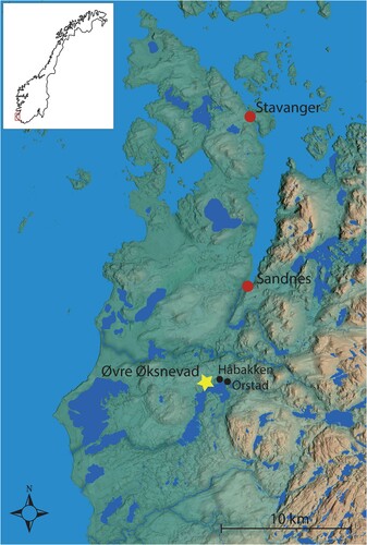
Figure 1. The location of the study site of Øvre Øksnevad in southwestern Norway. Nearby towns and other archaeological sites that are mentioned in the text are also marked. Map of Norway is inserted.
Material and Methods
Study Area and Archaeological Site
The study site is situated on a hill at Øvre Øksnevad, close to the town of Klepp in southwestern Norway. It lies around 40–50 m above sea level and looks out over the Lake Frøylandsvatnet (). The surrounding landscape is open and heavily influenced by human activity, consisting of a mixture of modern industry, residential areas and agricultural land. The climate is oceanic with relatively mild summers: the mean annual temperature is 6–8°C, and the annual precipitation is 1000–1500 mm (Moen Citation1999). The local area is undulating with thick Quaternary deposits, and the hill at Øvre Øksnevad is build-up of glaciofluvial sediments, mainly sorted sand and gravel, covered by approximately 40 cm of sandy till deposited during the last glacial retreat (Bergstrøm et al. Citation2010). The hill has previously been remodelled by recent gravel extraction, during which further archaeological remains were removed without documentation.
Excavations at Øvre Øksnevad took place in 2016 and revealed 103 cairns, three settlement areas including 6 houses, and several preserved prehistoric cultivation layers ( and ). Two relatively large grave mounds (approx. 20 m in diameter) were situated at the top of the hill, whereas the remaining cairns (approx. 2–5 m long) were distributed relatively evenly over the upper slopes to the south and east. Most of the cairns were circular or semi-circular, while a few were elongated. A linear stone feature was also uncovered (Cairn 6 in is situated within this feature), which partly surrounded one of the large grave mounds on top of the hill. The cultivation layers were found mainly on the lower terraces in depressions and in the slopes along the northern and southern edge of the hill. The settlement areas were situated in the eastern and central slopes, in three different areas, from where roughly 400 postholes along with a few fireplaces and cooking pits were uncovered. The houses were identified by two parallel rows of roof-bearing postholes with a total length of ca. 10–20 m, which is relatively short compared to other contemporary houses in the region. Four of the houses had a distinct outline with a fireplace (Houses 1, 2, 3 and 5) and two houses were more diffuse without fireplaces (Houses 4 and 6). Houses 4 and 6 were also covered by later cairns, and a few cooking pits at the site were situated stratigraphically above the cultivation layers. Finds related to the burials were scarce, although pottery was found scattered between the stones in several cairns. Potsherds were typologically dated to between 500 BC and AD 550. Some of the cairns were constructed with a central chamber, and contained fragmented pottery/burnt bone, which confirms their main purpose as markers or monuments for cremation burials (Bell and Denham Citation2020). In this study, we assume that all investigated cairns are for burial purposes, although it cannot be excluded that a few clearance cairns were constructed in connection with cultivation at the site.
Figure 2. Aerial photo of the archaeological site of Øvre Øksnevad (within red line) after the topsoil has been removed. Green colour marks features from which both pollen and macrofossils were analysed stratigraphically: through two cultivation layers (Profile 1–2), from two cairns (Cairn 37, Cairn 65), and from two combined profiles consisting of cultivation layers with cairns on top (Cairn 69 and Cairn 6). In addition, a variety of features were analysed only for plant macrofossil analysis: yellow colour marks houses (Houses 1–6) and orange colour marks cairns/profiles.
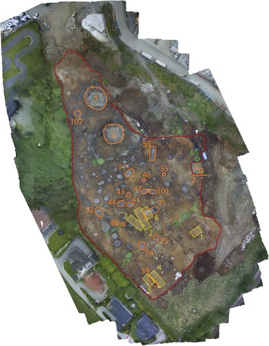
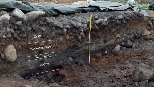
Figure 3. Picture of the vertical section of one of the analysed cairns (Cairn 6), with interpretation of stratigraphy, including layers accumulated before the cairn was constructed.
Radiocarbon Dating
In total, 43 samples were dated (37 pieces of charcoal, 4 cultivated seeds and 2 bone fragments) from archaeological investigations at Øvre Øksnevad (). In order to produce enough radiocarbon dates for the cairns (only two cairns contained enough human bone from a burial context for radiocarbon dating) charcoal was extracted from the upper and lower parts of the cairn to retrieve a minimum and maximum date respectively. In addition, charcoal fragments were used to date fireplaces, burnt layers, cultivation layers and cooking pits. Four seeds from cultivated plants were also dated: three Hordeum vulgare (barley) and one Linum usitatissimum (flax), from three postholes and a cultivation layer. The analyses were carried out using accelerator mass spectrometry at the 14CHRONO Centre in Belfast (UBA) and Beta Analytic in London (Beta). All radiocarbon dates were calibrated using OxCal v4.4.4 based on the IntCal20 calibration curve (Bronk Ramsey Citation2009; Reimer et al. Citation2020). In addition, the summed probability function in OxCal was used to get an overview of the distribution of all radiocarbon dates from the site (Bronk Ramsey Citation2017).
Table 1. All available radiocarbon dates obtained from the archaeological site Øvre Øksnevad, listed from youngest to oldest age.
Pollen and Multivariate Analyses
Samples for pollen analysis were extracted from six vertical sections: two profiles through cultivation layers, two profiles through cairns, and two combined profiles consisting of cultivation layers with cairns on top (). After standard pre-treatment (Berglund and Ralska-Jasiewiczowa Citation1986), twenty-nine samples were analysed for the content of pollen using a light microscope (400x and 1000x magnification, including phase contrast), literature/key (Moore, Webb, and Collinson Citation1991; Beug Citation2004) and the reference collection at the Museum of Archaeology, University of Stavanger. The Tilia software (v. 2.0.41) was used to create pollen percentage diagrams and identify local vegetation zones by constrained cluster analysis (Grimm Citation1987, Citation1992). Linear-based multivariate analysis, i.e. Principal component analysis (PCA), was used (a short gradient length was identified) to explore the variation in pollen composition between samples using Canoco (v. 5.0). All samples and pollen taxa were included in the PCA and the pollen percentage data were square root transformed (ter Braak and Šmilauer Citation2012).
Macrofossil and Charcoal Analysis
A variety of features were sampled for plant macrofossil analysis throughout the excavation at Øvre Øksnevad. In total 102 samples were analysed for macroscopic plant remains, including 7 samples analysed by Lundberg (Citation2017). However, only the samples that contained charred plant macrofossils (78 samples) were included in this study (Supplementary material 1). Of these samples were 3 from buried soil horizons, 5 from burnt layers, 6 from cultivation layers, 4 from cooking pits/fire places, 16 from postholes, 6 from grave contexts and 31 from cairns. In addition, 7 samples contained material from two or more separate contexts. As such, these samples cannot be conclusively assigned to any one particular phase of activity at the site and are therefore not discussed further in this paper.
Samples ranged in volume from 0.5 to 8 litres, and the total volume of soil processed was approx. 200 litres. The samples were processed by water flotation. The light fraction was retained on a 0.5 mm mesh and air-dried. The samples were then sorted and plant remains retrieved for analysis. Identifications of plant macrofossils were made by comparing observed characteristics with modern reference material, along with published and digital sources (Beijerinck Citation1947; Berggren Citation1969, Citation1981; Anderberg Citation1994; Cappers, Bekker, and Jans Citation2006; Jacomet Citation2006; Neef et al. Citation2012). Nomenclature used in the text, diagrams, and tables follows Mossberg and Stenberg (Citation2007).
Taxonomic identification of charcoal fragments was carried out in order to identify material suitable for radiocarbon dating. Charcoal analysis was carried out partly by an external contractor (A.J. Kirchhefer, Tromsø) and partly at the Museum of Archaeology, University of Stavanger. Taxonomic identifications were assigned by comparing suites of anatomical characteristics visible with those documented in reference atlases (Schweingruber Citation1990; Schoch et al. Citation2004; Hather Citation2000). Taxa with relatively short lifespans were preferentially selected for dating in order to give more accurate results; long-lived taxa such as Pinus sylvestris (Scots pine) and Quercus sp. (oak) were avoided. Taxonomic identifications of charcoal submitted for radiocarbon dating are given in .
Results
Pollen Composition in Profiles and Associated Dates
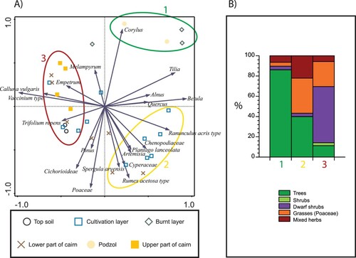
The pollen sum varied substantially between samples (from 105 to 741); in particular a few of the buried soil horizons and burnt layers showed relatively low pollen contents. Most of the pollen sequences show vertical variations in pollen content, which likely represent changes in vegetation cover over time (). By combining all pollen samples in the PCA, three relatively distinct groups could be identified (), which were combined to describe local pollen assemblage zones (LPAZ) as pollen samples with the same date range can be assumed to represent the same local environment. However, five samples were excluded from the LPAZ groupings as there was an overlap in pollen composition between some of the samples, in particular between samples from cultivation layers and the lower levels of cairns. The division in LPAZs was aided by the cluster analyses carried out for each pollen sequence separately.
Figure 4. Pollen diagrams with selected taxa from six cairns/profiles analysed in this study. Black bars show the percentages of the pollen sum and grey bars show exaggeration (percentages × 10). Inferred local pollen assemblage zones (no. 1–3) are also shown to the left.
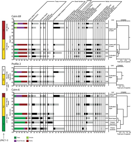
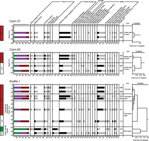
Figure 5. (A) Principal component analysis of all pollen samples included in this study, classified according to which type of soil/context the samples were extracted from. Inferred local pollen assemblage zone (no. 1–3) are also shown within ovals. (B) Mean pollen percentage for each local pollen assemblage zone (no. 1–3), inferred from the PCA and CONISS analyses.
The eight radiocarbon dates obtained from the stratigraphical sections range from c. 2100 to 500 BC, with the oldest dates obtained in the lower part of each profile (from layers with samples in LPAZ 1) and the younger dates obtained from the upper part of each profile (from layers with samples in LPAZ 3), which supports the division in LPAZs to explore the vegetation development over time. However, there was some overlap between dates obtained from layers with pollen samples assigned to LPAZ 1 and LPAZ 2.
LPAZ 1: Woodland – Corylus – Tilia
Four pollen samples (from Cairn 6 and Profile 1) were included in LPAZ 1 ( and ). The samples from Cairn 6 were from a podzol sequence and from a burnt layer immediately above. LPAZ 1 was dominated by trees, characterised by high amounts of Corylus (hazel) and Tilia (lime), up to approx. 20% and 40% pollen percentage respectively. Betula (birch) was also common (up to approx. 50%) but this tree was not characteristic only in this zone. A few herbs were identified, such as Melampyrum (cow-wheats), Poaceae (grass family) and Succisa (devil’s-bit scabious), but these taxa were rather variable between samples. Plantago lanceolata (ribwort plantain) was also identified in one of the burnt layers. The mean pollen composition, using all samples assigned to LPAZ 1, showed that tree pollen was dominant, comprising 86% of the total assemblage, with 4% dwarf shrubs, 4% grasses and 6% other herbs.
LPAZ 2: Herbs – Poaceae – Betula
Eight pollen samples (from Cairn 6, Cairn 69 and Profile 2) were included in LPAZ 2 ( and ). LPAZ 2 is dominated by Betula, Poaceae and a mixture of herbs. Common herbs were Artemisia (mugworts), Chenopodiaceae (goosefoot family), Cyperaceae (sedge family), Plantago lanceolata (ribwort plantain), Ranunculus acris type (buttercups), Rumex acetosa type (sorrel), Spergula arvensis (corn spurrey) and Persicaria maculosa (redshank). Cerealia undifferentiated (cereals), Hordeum type (barley) and Triticum type (wheat) were present in the samples from Cairn 69 and Cerealia undifferentiated from Profile 2. Combining the pollen samples assigned to LPAZ 2 resulted in a mean composition of 40% trees, 3% dwarf shrubs, 35% Poaceae and 22% other herbs.
LPAZ 3: Heathland – Calluna vulgaris
Twelve pollen samples (from Cairn 6, Cairn 69, Profile 1, Cairn 65 and Cairn 37) were included in LPAZ 3 ( and ). LPAZ 3 is dominated by the heathland plant Calluna vulgaris (heather), which comprises up to 75% of the total pollen composition. Poaceae was also common (up to 50%). Other heathland plants were also relatively common, such as Empetrum (crowberry) and Vaccinium type (bilberries), along with the grassland plants Trifolium repens (white clover) and Plantago lanceolata. A few grains of cereal pollen were identified in some of the profiles/cairns (i.e. Profile 1, Cairn 65 and Cairn 37). Combining the pollen samples assigned to LPAZ 3 showed a mean pollen composition of 11% trees, 3% shrubs, 55% dwarf shrubs, 25% Poaceae and 6% other herbs.
Radiocarbon Dates from Different Contexts
From House 1, Linum usitatissimum and Hordeum vulgare from two different postholes were both dated to c. 600 BC. From House 2, Hordeum vulgare from a posthole and charcoal from a fireplace were both dated to c. AD 200. Charcoal from a fireplace in House 4 was also dated to c. 600 BC. Twenty-seven dates obtained from grave contexts and within cairns gave a date range for the cairns of between 1900 BC and AD 1800 (a few were obviously older or younger than the cairns), of which two were obtained from human bones that returned dates of c. 600 BC and c. 300 BC. Radiocarbon dates on charcoal dated three cooking pits to AD 1-100, while another such feature was dated to c. 700 BC. Two cultivation layers were dated to c. 2300-1900 BC and two other cultivation layers dated to c. 600-500 BC (three on charcoal and one on Hordeum vulgare). Charcoal from one burnt layer was dated to c. 2100 BC and two others were dated to c. 1400-1300 BC.
Macrofossil Composition
The quantity of charred macroscopic plant remains identified was generally low, and only 78 of 102 samples contained any charred macrofossils. However, the concentration of charred plant macrofossils also varied significantly between samples, from 0.25 to 655 finds per litre of soil. The latter is unusually high compared to average plant macrofossil concentrations from archaeological contexts in southwestern Norway. The quantity and concentration also varied between soil categories, as described below (; Supplementary material 1). Macrofossil concentration was calculated excluding charcoal fragments, and averages presented below are based only on samples which produced plant macrofossils other than charcoal. The results presented here include seven samples analysed by Lundberg (Citation2017).
Figure 6. Mean macrofossil concentration (number per litre soil) and percent of total macrofossil composition for each group of features.
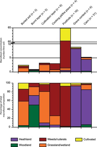
Although taxonomic identifications of charcoal were carried out on fragments to be submitted for radiocarbon dating, the results of this analysis are not discussed in detail here. As mentioned above, short-lived taxa such as Ericaceae (heather family), Corylus avellana (hazel), Betula sp. (birch) and Alnus sp. (alder) were preferentially selected for dating in order to avoid an ‘old wood’ bias in the dating results. The results therefore do not necessarily represent an accurate picture of the wood taxa present in the area and/or used as fuel at any given time. Further charcoal analysis was not carried out from the site as many samples contained too few charcoal fragments to give significant results. Nevertheless, as shows, charcoal fragments dated to AD 200 and earlier were generally identified as tree taxa, especially in the Betulaceae family. In contrast, the majority of charcoal fragments dated to the AD 1300 and later were identified as Ericaceae.
Most charred macrofossils were obtained from only a few postholes in Houses 1 and 2: the average macrofossil finds (not including charcoal) per litre of soil for Houses 1 and 2 respectively was 154 and 54, compared to an average of 3.5 from postholes in other Houses. The assemblage was dominated by weed seeds, mainly Chenopodium album (goosefoot), Persicaria lapathifolia (pale persicaria) and Spergula arvensis (corn spurry). A single posthole in House 1 contained 1760 Chenopodium album seeds. The postholes also contained a relatively large amount of seeds of cultivated species, mainly Linum usitatissimum (flax) from House 1, along with a few cereal grains including Avena sp. (oat), Hordeum vulgare (barley) and Triticum sp. (wheat) (Lundberg Citation2017).
Samples from grave contexts and within cairns were dominated by seeds of heathland plants, mainly Arctostaphylos uva-ursi (bearberry) and Empetrum nigrum (crowberry), but seeds of Rubus idaeus (raspberry) and remains of Calluna vulgaris (heather) were also identified. Cairn fills produced on average 5.6 plant macrofossils per litre, while the average from grave contexts was slightly higher at 8.8.
The cooking pits and fireplaces contained mainly macrofossils of weeds/ruderals, such as Persicaria lapathifolia and Chenopodium album, as well as some grassland/wetland plants such as Carex (sedges) and Potentilla erecta (tormentil). The average plant macrofossils per litre was 3.1.
The cultivation layers contained mainly macrofossils of grassland/wetland plants, mainly Poaceae (grass family) and Danthonia decumbens (heath-grass). Weeds/ruderals were the second most common category, including species such as Persicaria lapathifolia and Spergula arvensis.
Few macrofossils were identified from the burnt layers (on average 1.3/litre), including the woodland taxa Pinus sylvestris (Scots pine) and Sambucus nigra (elder), and the grassland/wetland taxa Carex spp. and Poaceae. Charred plant macrofossils of taxa from a range of land-use types, including Cerealia (cereals), Corylus avellana, Carex spp. and Rumex acetosella (sheep’s sorrel), were found in the buried soil layers, although find quantities here were also low, at 2.4 macrofossils per litre on average.
The plant macrofossil finds vary more significantly between context types than over time. Heathland plants were most common in cairn fills and grave contexts, where remains of cultivated plants and weeds/ruderals were rare. In contrast, the latter two groups were common in samples from houses, especially House 1 and House 2. Grassland and wetland plants were found in small quantities in all context types, but were most common in samples from cultivation layers. Macrofossils of woodland plants were rare in all context types, however occasional fragments of Corylus avellana nutshell attest to the continued presence and/or exploitation of this taxon throughout the occupation of the site. Of the cultivated plants, Linum usitatissimum, Avena and Triticum were only found in House 1, dated to c. 600 BC, while Hordeum was also noted in House 2, dated to c. AD 200. Chenopodium album appears to have been a common weed in all periods with cultivated plants. Persicaria lapathifolia seems to have been much more common c. AD 200, but as this is based on a large quantity of finds from a single sample in House 2, it cannot necessarily be applied to the whole site.
Discussion
Early Traces of Human Activity
The oldest pollen samples from Øvre Øksnevad date from before c. 2100 BC and likely represent the vegetation at the site before any major human impact ( and ). The pollen composition in these samples suggests a landscape dominated by deciduous trees (LPAZ 1), mainly Betula and Corylus, with minor components of Alnus, Pinus and Quercus. These taxa were common in western Norway, in particular prior to introduction of agriculture (Prøsch-Danielsen and Simonsen Citation2000; Hjelle et al. Citation2018). A fragment of charred hazelnut shell from the same stratigraphic level (Supplementary material 1) supports the presence of Corylus avellana in the local landscape at this time. Small quantities of pollen grains from herbs and dwarf shrubs indicate minor openings in the woodland, which was the only evidence of human activity at the site identified in LPAZ 1.
Similar pollen composition, suggesting a dominance of a deciduous woodland, was identified in two burnt layers from the site. However, one additional sample from one of these burnt layers was dominated by Calluna vulgaris and contained a few pollen cereal grains, and several samples contained taxa indicating pastoral activity (such as Plantago lanceolata and Ranunculus acris type) and cultivation (weed taxa such as Persicaria maculosa) (Hjelle Citation1999; Gaillard Citation2007; Fredh, Prøsch-Danielsen, and Jensen Citation2022). Macrofossils from the burnt layers, such as Pinus sylvestris, Sambucus nigra, Carex spp. and Poaceae, also indicate a mixture of woodland and open land. Macrofossils from woody plants probably represent trees that were burnt after clearing the land, while the herbs may either have been growing in patches of open land or incorporated during later activities. Hence, these burnt layers contained botanical remains from different types of landscapes. Probably soils of different ages were mixed during cultivation, or alternatively, fuel gathered by humans prior to burning yielded an unusual composition in some of the samples.
The dates obtained from burnt layers (c. 2100 BC and c. 1400-1300 BC) and from cultivation layers (c. 2300-1900 BC and c. 600-500 BC) suggest several phases of woodland clearance and cultivation at Øvre Øksnevad (). The earliest phase is contemporary with the period of transition to an agricultural economy in southwestern Norway (Soltvedt Citation2000; Diinhoff Citation2005). The land at Øvre Øksnevad was probably cleared to make way for grasslands and arable fields belonging to a settlement situated nearby. This settlement must have been outside the excavated area, as no traces of settlement have been identified from this period at Øvre Øksnevad.
The earliest cultivation layer analysed contained no cereal pollen, but the layer was homogenous, cleared of larger stones and contained macroscopic charcoal. These characteristics are typical for prehistoric cultivation layers in the region (Halvorsen and Hjelle Citation2017; Fredh, Prøsch-Danielsen, and Jensen Citation2022). The layer also contained pollen from several characteristic arable weeds, such as Persicaria maculosa and Spergula arvensis, and grassland indicators, such as Plantago lanceolata and Rumex acetosa type. This pollen composition is similar to pollen assemblages from later cultivation layers (LPAZ 2). In general, cultivation layers older than around 500 BC contain relatively few pollen cereal grains, probably due to the fact that cultivation was fairly small-scale (Fredh, Prøsch-Danielsen, and Jensen Citation2022). A large proportion of tree pollen (mainly Betula) in the cultivation layers can be attributed to the fact that open land taxa are usually underestimated in pollen records (Broström et al. Citation1998; Sugita, Gaillard, and Broström Citation1999). The macrofossil assemblage from the cultivation layers contained both arable weeds and grassland taxa, which also suggests a mixture of cultivated fields and pastures. It is likely that the landscape was mainly open, with some patches of woodland remaining.
Main Activity at the Site
Most of the dates at Øvre Øksnevad were obtained from c. 600-300 BC, which suggests that the main human activity at the site was happening at this time ( and ). Settlements were likely established then, and cultivation continued. The pollen composition was rather variable between samples, i.e. characterised by pollen both from grasses/herbs (LPAZ 2) and from dwarf shrubs/grasses (LPAZ 3) ( and ). The lower part of the profiles (generally older) dated to this interval generally contained more taxa related to human activity, such as cereals, weeds and ruderal plants, e.g. Artemisia and Persicaria maculosa, as well as more tree pollen. The upper parts (generally younger) contained more pollen from heathland plants, and indicate a slightly more open landscape. This development suggests that further woodland clearance took place when the settlement became established and that heathland developed during this relatively short time interval, while some crop cultivation was still carried out. The pollen composition was also similar between some of the different features (cultivation layers and cairns), which indicates that these overlap in time. Some of the overlap in pollen composition can also be explained by the possibility that some of the graves could have been constructed using soils containing older pollen.
Figure 7. All radiocarbon dates obtained from the study site, shown with 2σ range and ordered according to age. Most of these dates are also presented in Bell and Denham (Citation2020) and two dates marked with* are from a previous registration of archaeological remains at the site (Fyllingen Citation2008).
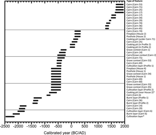
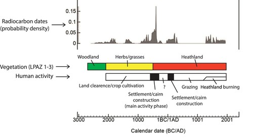
Figure 8. Distribution of all radiocarbon dates from the site using summed probability function in OxCal (Bronk Ramsey Citation2017), compared to the overall interpretation of main vegetation and human activity phases at Øvre Øksnevad.
The pollen data and radiocarbon dates also suggest that the grave field was related to the settlements at Øvre Øksnevad. Secure evidence of graves includes two human bone fragments that were dated to this interval (c. 600 BC and 300 BC). However, considering the large age range of some of the radiocarbon dates, it is possible that a few burial cairns were built after the settlement was abandoned. This development is somewhat supported by the general stratigraphy at the site, with the graves sometimes found on top of cultivation layers and settlement features (never the other way around). However, there were four dates from cairns that were older than the ‘main activity phase’, ranging between c. 1900 and 900 BC. It is unlikely that these cairns were built without any associated settlement, and these dates should probably be considered maximum ages for these cairns. The pottery found in some of the cairns was characteristic for the period 500 BC–AD 500, which supports the hypothesis that the main activity at the site occurred at this time.
The macrofossil composition in one of the houses dated to this period (house 1), and contemporary with some of the cultivation layers found on the site, was dominated by arable weeds and cultivated plants, which suggests arable agricultural activity, possibly including crop processing taking place inside the house. The main cereal identified was Hordeum vulgare. The dominance of this crop is in agreement with the regional picture which shows that barley was dominant in the area throughout prehistory (Prøsch-Danielsen and Soltvedt Citation2011), although too few charred cereals were identified to estimate any ratios between cultivated plants. The charred flax seeds (Linum usitatissimum) dated from house 1 (748-402 BC) provide the oldest date so far of flax in Norway. Lundberg (Citation2017) investigated how these flax seeds were affected by temperature (i.e. preservation characteristics) and compared their size to other flax seeds in Scandinavia, which suggested that these were most likely grown for textile fibres.
Heathland Development
Pollen from Calluna vulgaris was dominant in the upper part of the cultivation layers and within the cairns (dated to c. 500 BC or later), mostly assigned to LPAZ 3, i.e. characterised by heathland plants and grasses ( and ). In these samples, the taxa indicating open landscapes dominated but herb diversity was relatively low. This pollen composition suggests that grazing may have become dominant in the latter part of the ‘main activity phase’ and possibly continued after the settlement was abandoned. The macrofossil assemblages from grave contexts and within cairns were dominated by seeds from heathland plants, which is in agreement with the pollen record, and supports the idea that heathland developed during the main activity phase and that most of the cairns were constructed during this time period or later.
A second settlement phase was identified around c. AD 1-200 at the site, through the remains of houses along with a few cooking pits. It seems that the site was again used for settlement activities, but within a landscape dominated by heathland (). It is possible that this settlement phase is a continuation of the previous phase at Øvre Øksnevad, but the dates available suggest a hiatus between two separate phases. There are no cultivation layers identified during this phase, which suggests a different pattern of land use in this settlement phase compared to the previous one. However, the house dated to this time interval (house 2) also contained charred seeds from cereals and weeds. These seeds indicate a continuation of crop cultivation, but this activity could have been carried out outside the excavated area. Two cairns were dated to this second settlement phase, and two graves were situated on top of postholes dated to this time period, which suggests that at least a few burial cairns were also related to this settlement.
Layers from the upper part of the sections from which pollen samples were analysed were not radiocarbon dated, but some were stratigraphically positioned above layers dated to c. 500 BC. Although these samples were dominated by heath- and grassland plants, a few cereal and weed pollen grains were also identified, which indicate crop cultivation. However, these grains could have been transported from some distance away. A few profiles showed imprints of roots penetrating into the cultivation layers below, which suggests some reforestation occurred after the settlement was abandoned, however, this potential woodland expansion was not visible in the pollen data. However, there were no radiocarbon dates between c. AD 200 and AD 1300, and no stratigraphical layers seems to have been formed, which supports a decline in human activity in this time period.
Nine of the radiocarbon dates obtained from within cairns were carried out on charred heathland plants, which provided ages that were evidently younger than the cairns. This deviation suggests charred plant material has been transported into the upper part of the graves, for example by root bioturbation, and cannot be used to date the cairns more than providing a minimum age. Nonetheless, these relatively young dates suggest human activity from c. AD 1300 to recent times, probably from burning the heathland to improve the pastures. This vegetation management practice is known in Norway from as early as 4000 BC, and is still carried out in some areas (Kaland and Kvamme Citation2013). However, the pollen data suggest that heathland developed during the main activity phase (c. 500 BC) and dominated the landscape most of the time until present, which is shown by the pollen content in several different types of layers. Possibly the heathland developed and was kept open by grazing (at least for some time), but the practice of regularly burning heather, shown by the dates from charred heathland plants, only started in this area around AD 1300.
The Regional Perspective and Challenges of This Type of Study
Several studies have used on-site botanical analyses for environmental reconstruction, but they commonly acknowledge that there can be some limitations (Sageidet Citation2005a; Overland and Hjelle Citation2013). Several factors affecting the stratigraphical resolution in soils have been suggested, such as physical mixing by human activity, bioturbation, selective degradation and downwash of pollen (Havinga Citation1984; Andersen Citation1979; Kelso Citation1994; Tipping et al. Citation1999). Davidson et al. (Citation1999) rejected the downwash of pollen and suggested that bioturbation was the main agent for mixing soils of different ages. The type of soil may also been important as acidic soils and waterlogged environments are generally less susceptible to bioturbation. Consequently, most studies conclude that it is only possible to obtain a coarse temporal resolution from minerogenic soils. Such data should only be used to infer general land-use development, which reflects how we use the palaeobotanical data in this study.
In the present study, selective degradation was indicated by a large amount of Tilia pollen, which is resistant to degradation and is commonly overrepresented in pollen records from soils with poor preservation conditions (Havinga Citation1984). However, this was only identified in a few samples in the podsol and burnt layers. Mixing by human activity was of course present in the cultivation layers by arding (ploughing). However, distinct layers are still observed in these cultivation layers, and the pollen composition varies stratigraphically when analysing thicker deposits, which has previously been identified regionally (Fredh, Prøsch-Danielsen, and Jensen Citation2022). Less bioturbation is expected in acid areas where podzols develop, such as in the present study area, but the soil conditions may have changed over time, and that some bioturbation has occurred cannot be excluded. Root penetration was however likely by heather, suggested by the relatively young dates from the cairns.
As mentioned earlier, there is not enough evidence to confirm that all cairns at the site were used for funeral practices, which is a common problem in Norwegian archaeology (Bjørlo Citation2020). Clearance cairns are also common in the region, which can be similar in appearance, and both types are often empty of finds. However, many cairns at Øvre Øksnevad contained shards of pottery, some with a central chamber, and a few with fragmented pottery/burnt bone, suggests their main purpose was for funeral practices. There is also evidence in Scandinavia of cairns containing a mix of ritual and practical elements, showing the complexity of differentiating the cairns from this time (Petersson Citation2020). However, for the purpose of analysing the environmental history of a site, the different types of cairns can be used in a similar way, as they both work as a trap for botanical remains. The type of cairn is therefore not crucial in the type of study presented here, focusing on the vegetation and land-use development.
Another concern in the present study was the history of the soil being used for cairn construction, i.e. if the soil was accumulated successively between the stones (during and/or after construction), or if the soil was formed earlier and put between stones during construction and therefore represents an older environment. However, the development within each profile analysed showed stratigraphical differences, and the profiles were comparable to each other, previously noted at other cairn sites in Norway (Overland and Hjelle Citation2013; Prøsch-Danielsen Citation1996). These observations support the idea that the soils within the cairns were formed during or after their construction, i.e. that the stratigraphy in the cairns and surrounding soils seems to be intact. Similar conclusions were drawn in relation to studies carried out at the two nearby archaeological sites Håbakken (Bysveen Citation1984) and Orstad (Sageidet Citation2009) ().
At Håbakken, three clearance cairns analysed for pollen content showed a similar land-use development as at Øvre Øksnevad. Two pollen assemblages comparable to Øvre Øksnevad were represented (LPAZ 2 and LPAZ 3), i.e. indicating a transition from a semi-open cultural landscape to a heathland dominated landscape (Bysveen Citation1984). In addition, a phase dominated by coniferous pollen representing modern plantations was identified at Håbakken, including spruce that does not grow naturally in the region. This recent phase was not identified in the current study, as Øvre Øksnevad seems to has been kept open until present. This difference shows some regional variation in land use in modern times. However, no radiocarbon dates were obtained from the cairns at Håbakken, and comparisons with other sites should therefore be tentative.
At Orstad, a series of sections were analysed for pollen and radiocarbon dating along and next to an 84 m long trench across the study area, complemented by soil micromorphology and geochemical analyses (Sageidet Citation2005a, Citation2005b, Citation2009). The analyses at Orstad showed a dominance of deciduous woodland prior to c. 2000 BC, a land clearance followed by occasional small-scaled cultivation c. 2000-500 BC, and then the development of heathland used for grazing c. 500 BC-present. The vegetation and land use history at Orstad follows the general pattern identified at Øvre Øksnevad, but with somewhat different start time and length of the different phases. In addition, an earlier phase of pastoral activity was identified at Orstad around 3000-2500 BC.
Some of the more traditional pollen diagrams from the region, i.e. based on lake or bog sediments, show the first indication of human activity from c. 4000 BC, mainly associated with minor woodland clearances (Solem Citation2005; Hjelle et al. Citation2018). More substantial changes are observed c. 2400-2000 BC, in connection with the regional transition to an agricultural economy (Soltvedt Citation2000; Prøsch-Danielsen and Sandgren Citation2003; Diinhoff Citation2005). This is when the first human activity is registered at Øvre Øksnevad. However, the first settlement is not identified until c. 600 BC, which is late in a regional context (Børsheim Citation2005). Consequently, the settlement at Øvre Øksnevad was likely established during a period of expansion, possibly in relation to the agricultural reorganisation in western Norway that started c. 500 BC, generally attributed to the establishment of the inland/outfield system and permanent fields (Soltvedt et al. Citation2007; Halvorsen and Hjelle Citation2017). The expansion of heathland at Øvre Øksnevad at c. 500 BC was also c. 300 years later than the regional pattern (Prøsch-Danielsen and Simonsen Citation2000; Solem Citation2005; Hjelle et al. Citation2018).
Furthermore, the pollen record at Øvre Øksnevad also indicates decreased crop cultivation after c. 500 BC, which is contrary to the regional pattern (Prøsch-Danielsen and Simonsen Citation2000; Solem Citation2005; Fredh, Prøsch-Danielsen, and Jensen Citation2022; Hjelle et al. Citation2018). It is possible that the expansion of heathland from 500 BC contributed to soil depletion that limited the possibility for crop cultivation over time. The relatively early abandonment of the settlement at Øvre Øksnevad at c. AD 200 suggests the area was mainly used during periods of high population pressure. The early Iron Age (500 BC–AD 550) is a period of expansion in southwestern Norway, and the site could have been used for occupation when needed, while normally used for less intensive activities. It should also be noted that after AD 550, the region is known for widespread abandonment, following the sixth century crisis (Gräslund and Price Citation2012), which could explain some of the reduced activity in later periods, when people seem to have centred around more well-established farms. Archaeological evidence from the surroundings suggests that Øvre Øksnevad was not an isolated settlement, as contemporary burial cairns and settlement activities have been identified nearby (within approx. 3 km) (Braathen Citation1978; Hemdorff Citation1987; Skauen Citation1997). The settlement pattern could have varied over time in relation to population variations and shifting land-use practices. The grave field at Øvre Øksnevad may also have changed its status over time due to variations in ritual practices.
Conclusions
The botanical analyses carried out in connection with the excavation at Øvre Øksnevad aided in the interpretation of the archaeological features and provided an environmental context. It was rather challenging to combine samples from different types of archaeological contexts. Although a pattern was identified, it should only be used to describe the general features in data set, rather than small variations between samples. The pollen record, in combination with the radiocarbon dates, provided the basis for interpreting the development of the site, as the pollen data showed a clear variation over time. On the other hand, the macrofossil samples generally contained few identified remains, and could therefore not be used to investigate the stratigraphic development based on a few sections alone. Instead, the macrofossil data showed a similar composition between samples from the same type of features, and was therefore used to infer environmental evidence for the time period(s) the different archaeological features were dated to.
This study has shown that prior to 2100 BC the landscape around Øvre Øksnevad was covered by deciduous trees, mainly Betula and Corylus. Minor impacts of human activity can be inferred from the dominance of these light-demanding trees that are favoured by woodland clearences, and from pollen of herbs and dwarf shrubs that may indicate minor openings in the woodland. Between c. 2100-500 BC, several phases of land clearance followed by crop cultivation were identified. The landscape was mainly open, dominated by herbs and grasses with some minor patches of woodland remaining. Within this type of landscape, a settlement was established c. 600 BC, which started the main phase of human activity on the site, including settlement, crop cultivation and cairn construction. Heathland started to develop during main phase of human activity, and from c. 500 BC, this was the dominant land cover. The main phase of human activity seems to have been over by c. 300 BC, and the use of the area was reduced to pastoral activity. A new short-lived settlement phase was established within the heathland landscape (c. AD 1-200), although no arable land was identified in the vicinity. Regular burning of heathland was present from AD 1300. Overall, the reconstructed land-use pattern was similar to the regional development, with the exception of the last c. 2400 years, when a relatively low amount of crop cultivation was identified at the site, suggesting that the main settlement area was elsewhere. The short-lived settlement at Øvre Øksnevad suggests it was marginal and only settled during periods of high population pressure.
Supplemental Material
Download MS Word (90.2 KB)Acknowledgements
A lot of people were involved in the development-led excavation at Øvre Øksnevad that enabled this study. In particular we thank Theo Gil Bell, Sean Denham, Sara Westling, Ida Lundberg and Daniel Smeds for encouraging discussions and support during sampling.
Disclosure Statement
No potential conflict of interest was reported by the author(s).
Additional information
Notes on contributors
Erik Daniel Fredh
Erik Daniel Fredh is a palaeoecologist/Associate Professor at the University of Stavanger with focus on archaeological applications. His research examines prehistoric land-use and agricultural practices, primarily using quantitative vegetation reconstructions based on fossil pollen records.
Dawn Elise Mooney
Dawn Elise Mooney is an environmental archaeologist and co-chair of the EAA Community of Research on Wild Plant Resources (ARCHWILD). Her research interests lie mainly in human-plant interactions in marginal (especially coastal) environments, particularly in the North Atlantic.
References
- Anderberg, A.-L. 1994. Atlas of Seeds and Small Fruits from Northwest-European Plant Species: Part 4. Resedaceae – Umbellifereae. Stockholm: Swedish Museum of Natural History.
- Andersen, S. T. 1979. “Brown Earth and Podzol: Soil Genesis Illuminated by Microfossil Analysis.” Boreas 8: 59–73.
- Beijerinck, W. 1947. Zadenatlas der Nederlandsche Flora. Wageningen: Veenman & Zonen.
- Bell, T. G., and S. D. Denham. 2020. “What to Do When the Results are Insufficient: Lessons from the Excavation of a Cairn Field at Eikebakken, Øvre Øksnevad, Klepp.” AmS-Varia 61: 61–75. Stavanger.
- Berggren, G. 1969. Atlas of Seeds and Small Fruits of Northwest-European Plant Species: Part 2. Cyperaceae. Stockholm: Swedish Natural Science Research Council.
- Berggren, G. 1981. Atlas of Seeds and Small Fruits of Northwest-European Plant Species: Part 3. Salicaceae – Cruciferae. Stockholm: Swedish Natural Science Research Council.
- Berglund, B. E., and M. Ralska-Jasiewiczowa. 1986. “Pollen Analysis and Pollen Diagrams.” In Handbook of Holocene Palaeoecology and Palaeohydrology, edited by B. E. Berglund, 455–484. Chichester: John Wiley and Sons.
- Bergstrøm, B., L. Olsen, K. Riiber, and A. J. Reite. 2010. Rogaland Fylke, løsmassekart M 1:200,000. Trondheim: Norges geologiske undersøkelse.
- Beug, H. J. 2004. Leitfaden der Pollenbestimmung für Mitteleuropa und angrenzende Gebiete. München: Pfeil.
- Bjørlo, A. H. 2020. “Cairns as Phenomena. Clearance- or Burial Cairns?” AmS-Varia 61: 31–41. Stavanger.
- Børsheim, R. L. 2005. “Two-aisled Houses in the Neolithic and Oldest Bronze Age.” AmS-Varia 43: 109–121. Stavanger.
- Braathen, H. 1978. “Øksnevadfunnet – en foreløpig melding.” Frá haug ok heiðni 3: 79–81.
- Bronk Ramsey, C. 2009. “Bayesian Analysis of Radiocarbon Dates.” Radiocarbon 51: 337–360.
- Bronk Ramsey, C. 2017. “Methods for Summarizing Radiocarbon Datasets.” Radiocarbon 59: 1809–1833.
- Broström, A., M.-J. Gaillard, M. Ihse, and B. Odgaard. 1998. “Pollen-landscape Relationship in Modern Analogues of Ancient Cultural Landscapes in Southern Sweden – a First Step Towards Quantification of Vegetation Openness in the Past.” Vegetation History and Archaeobotany 7: 189–201.
- Bysveen, M. A. 1984. Pollenanalytiske undersøkelser fra et røysfelt på Håbakken i Klepp kommune, Rogaland. Report. Stavanger: University of Stavanger/Museum of Archaeology.
- Cappers, R. T. J., R. M. Bekker, and J. E. A. Jans. 2006. Digitale Zadenatlas van Nederland. Groningen: Barkhuis.
- Caseldine, C. J., and J. A. Matthews. 1985. “14C Dating of Paleosols, Pollen Analysis and Landscape Change: Studies from the Lowand Mid-Alpine Belts of Southern Norway.” In Soils and Quaternary Landscape Evolution, edited by J. Boardman, 87–116. Chichester: John Wiley.
- Davidson, D. A., S. Carter, B. Boag, D. Long, R. Tipping, and A. Tyler. 1999. “Analysis of Pollen in Soils: Processes of Incorporation and Redistribution of Pollen in Five Soil Profile Types.” Soil Biology & Biochemistry 31: 643–653.
- Diinhoff, S. 2005. “Den vestnorske agrarbosætning. Fra sen stenalder til folkevandringstid. Arkeologiske resultater fra et tiår med fladeafdækninger på Vestlandet.” AmS-Varia 43: 75–85. Stavanger.
- Dimbleby, G. W. 1985. The Palynology of Archaeological Sites. Studies in Archaeological Science. London: Academic Press.
- Fredh, D., L. Prøsch-Danielsen, and C. E. Jensen. 2022. “A Synthesis of Pollen Composition in Prehistoric Cultivation Layers in Southwestern Norway.” Environmental Archaeology 27: 127–145.
- Fyllingen, H. 2008. Arkeologiske registreringer og forundersøkelse på Øvre Øksnevad gnr. 8, bnr. 8, Klepp k., Rogaland. Report 2008/25. Stavanger: University of Stavanger/Museum of Archaeology.
- Gaillard, M.-J. 2007. “Pollen Methods and Studies: Archaeological Applications.” In Encyclopedia of Quaternary Science, edited by S. Elias, 2571–2595. Amsterdam: Elsevier.
- Gräslund, B., and N. Price. 2012. “Twilight of the Gods? The ‘Dust Veil Event’ of AD 536 in Critical Perspective.” Antiquity 86: 428–443.
- Grimm, E. 1987. “CONISS: A FORTRAN 77 Program for Stratigraphically Constrained Cluster Analysis by the Method of Incremental Sum of Squares.” Computers & Geosciences 13: 13–35.
- Grimm, E. C. 1992. “TILIA and TILIA GRAPH: Pollen spreadsheet and graphics program.” In 8th International Palynological Congress (Aix-en-Provence, France), Program and Abstracts, p. 56.
- Halvorsen, L., and K. L. Hjelle. 2017. “Prehistoric Agriculture in Western Norway – Evidence for Shifting and Permanent Cultivation Based on Botanical Investigations from Archaeological Sites.” Journal of Archaeological Science: Reports 13: 682–696.
- Hather, J. G. 2000. The Identification of the Northern European Woods. A Guide for Archaeologists and Conservators. London: Routledge.
- Havinga, A. J. 1984. “A 20-Years Experimental Investigation into the Differential Corrosion Susceptibility of Pollen and Spores in Various Soil Types.” Pollen et Spores 26: 541–558.
- Hemdorff, O. 1987. “Langhus fra slutten av bronsealder – funnet på Håbakken i Klepp.” Frá haug ok heiðni 3: 228–235.
- Hjelle, K. L. 1999. “Modern Pollen Assemblages from Mown and Grazed Vegetation Types in Western Norway.” Review of Palaeobotany and Palynology 107: 55–81.
- Hjelle, K. L., L. S. Halvorsen, L. Prøsch-Danielsen, S. Sugita, A. Paus, P. E. Kaland, I. K. Mehl, et al. 2018. “Long-term Changes in Regional Vegetation Cover Along the West Coast of Southern Norway: The Importance of Human Impact.” Journal of Vegetation Science 29: 404–415.
- Hjelle, K. L., A. K. Hufthammer, and K. A. Bergsvik. 2006. “Hesitant Hunters: A Review of the Introduction of Agriculture in Western Norway.” Environmental Archaeology 11: 147–170.
- Hjelle, K. L., T. Solem, L. S. Halvorsen, and L. I. Åstveit. 2012. “Human Impact and Landscape Utilization from the Mesolithic to Medieval Time Traced by High Spatial Resolution Pollen Analysis and Numerical Methods.” Journal of Archaeological Science 39: 1368–1379.
- Høgestøl, M., and L. Prøsch-Danielsen. 2006. “Impulses of Agro-Pastoralism in the 4th and 3rd Millennia BC on the South-Western Coastal Rim of Norway.” Environmental Archaeology 11: 19–34.
- Jacobson, G. L., and R. H. W. Bradshaw. 1981. “The Selection of Sites for Paleovegetational Studies.” Quaternary Research 16: 80–96.
- Jacomet, S. 2006. Identification of Cereal Remains from Archaeological Sites. Basel: Archaeobotany lab, IPAS, Basel University.
- Kaland, P. E., and M. Kvamme. 2013. Kystlyngheiene i Norge – kunnskapsstatus og beskrivelse av 23 referanseområder. Bergen: Miljødirektoratet.
- Kelso, G. K. 1994. “Pollen Percolation Rates in Euroamerican-era Cultural Deposits in the Northeastern United States.” Journal of Archaeological Science 21: 481–488.
- Lundberg, I. 2017. “Norges första oljeexploatering? En arkeobotanisk och morfometrisk undersökning av linfrön från Eikebakken, Norge.” Bachelor Thesis. Umeå: Umeå University.
- Moen, A. 1999. National Atlas of Norway. Vegetation. Hønefoss: Norwegian Mapping Authority.
- Moore, P. D., J. A. Webb, and M. E. Collinson. 1991. Pollen Analysis. 2nd ed. Oxford: Blackwell.
- Mossberg, B., and L. Stenberg. 2007. Gyldendals Store Nordiske Flora. Revidert og utvidet utgave. Oslo: Gyldendal Norsk Forlag.
- Neef, R., R. T. J. Cappers, R. M. Bekker, L. Boulous, M. Dinies, Z. F. Ertuğ, N. Keller, M. Lahitte, G. J. Meulenbeld, and Y. P. Zhu. 2012. Digital Atlas of Economic Plants in Archaeology. Groningen: Barkhuis & Groningen University Library.
- Overland, A., and K. L. Hjelle. 2013. “Pollen Analysis in the Context of Clearance Cairns from Boreal Forests – a Reflection of Past Cultivation and Pastoral Farming.” Journal of Archaeological Science 40: 1029–1041.
- Petersson, M. 2020. “A Clearance Cairn Site at Farstorp – Cultivation, Burial and Ritual.” AmS-Varia 61: 115–137. Stavanger.
- Prøsch-Danielsen, L. 1996. “Vegetasjonshistorisk undersøkelse av felt med rydningsrøyser på Forsand gnr. 41 bnr. 6, Forsand i Rogaland.” NIKU Oppdragsmeld 10: 1–31.
- Prøsch-Danielsen, L., and P. Sandgren. 2003. “The Use of Pollen, Magnetic and Carbon Analyses in Identifying Agricultural Activity and Soil Erosion from the Neolithic to the Iron Age – A Study of Two Lake Sediment Cores from Jæren, South-Western Norway.” Environmental Archaeology 8: 33–50.
- Prøsch-Danielsen, L., and A. Simonsen. 2000. “Palaeoecological Investigations Towards the Reconstruction of the History of Forest Clearances and Coastal Heathlands in South-Western Norway.” Vegetation History and Archaeobotany 9: 189–204.
- Prøsch-Danielsen, L., and E.-C. Soltvedt. 2011. “From Saddle to Rotary – Hand Querns in South-Western Norway and the Corresponding Crop Plant Assemblages.” Acta Archaeologica 82: 129–162.
- Reimer, P., W. Austin, E. Bard, A. Bayliss, P. Blackwell, C. Bronk Ramsey, M. Butzin, et al. 2020. “The IntCal20 Northern Hemisphere Radiocarbon age Calibration Curve (0–55 cal kBP).” Radiocarbon 62: 725–757.
- Sageidet, B. M. 2005a. “Soil Pollen Analysis of a Podsol and a Clearance Cairn Confirms Bronze Age Agriculture at Orstad, South-Western Norway.” Journal of Nordic Archaeological Science 15: 57–75.
- Sageidet, B. M. 2005b. “Sub-local Differences in Late Holocene Land Use at Orstad, Jæren in SW Norway, Revealed by Soil Pollen Stratigraphy.” Environmental Arcaeology 10: 51–71.
- Sageidet, B. M. 2009. “Late Holocene Land use at Orstad, Jæren, Southwestern Norway, Evidence from Pollen Analysis and Soil Micromorphology.” Catena 78: 198–217.
- Schoch, W., I. Heller, F. H. Schweingruber, and F. Kienast. 2004. Wood anatomy of central European Species. Accessed 4 August 2021. http://www.woodanatomy.ch/.
- Schweingruber, F. H. 1990. Anatomie Europäischer Holzer - Anatomy of European Woods. Stuttgart: Haupt.
- Segerström, U. 1991. “Soil Pollen Analysis – an Application for Tracing Ancient Arable Patches.” Journal of Archaeological Science 18: 165–175.
- Skauen, I. 1997. “Utgraving av gravrøyser og bosetningsspor på Øksnevad, Klepp kommune.” Frá haug ok heiðni 1: 39–42.
- Solem, T. 2005. Vegetasjonshistoriske undersøkelser av Lonartjønna på gården Norheim gnr. 19, Time kommune, Rogaland. Report 2005/16. Stavanger: University of Stavanger/Museum of Archaeology.
- Soltvedt, E.-C. 2000. “Carbonised Cereal from Three Late Neolithic and two Early Bronze Age Sites in Western Norway.” Environmental Archaeology 5: 49–62.
- Soltvedt, E.-C., T. Løken, L. Prøsch-Danielsen, R. L. Børsheim, and K. Oma. 2007. Bøndene på Kvålehodlene. Boplass-, jordbruks- og landkapsutvikling gjennom 6000 år på Jæren, SV Norge. Stavanger: Museum of Archaeology. (AmS-Varia 47).
- Sørensen, L., and S. Karg. 2014. “The Expansion of Agrarian Societies Towards the North – New Evidence for Agriculture During the Mesolithic/Neolithic Transition in Southern Scandinavia.” Journal of Archaeological Science 51: 98–114.
- Sugita, S. 1994. “Pollen Representation of Vegetation in Quaternary Sediments: Theory and Method in Patchy Vegetation.” Journal of Ecology 82: 881–897.
- Sugita, S., M.-J. Gaillard, and A. Broström. 1999. “Landscape Openness and Pollen Records: A Simulation Approach.” The Holocene 9: 409–421.
- ter Braak, C. J. F., and P. Šmilauer. 2012. Canoco Reference Manual and User’s Guide: Software for Ordination (Version 5.0). Ithaca: Microcomputer Power.
- Tipping, R., D. Long, S. Carter, D. A. Davidson, A. Tyler, and B. Boag. 1999. “Testing the Potential of Soil-Stratigraphic Palynology in Podzols.” In Geoarchaeology: Exploration, Environments, Resources. Special Publications 165, edited by A. M. Pollard, 79–90. London: The Geological Society of London.