
ABSTRACT
Archaeological and palaeoecological evidence relating to human activity in the English Midlands is scant compared to elsewhere in Britain. Knowledge of human activity in pre-Roman and Roman times is often fragmentary and disparate in parts of the region where it could be assumed that the resident population was small with little Roman impact. To examine these contentions, a palaeoenvironmental investigation from Aqualate Mere near Newport, Staffordshire, has been undertaken on the sediment record extending back to c. 1300 cal. BC. An analysis of microfossils, microscopic charcoal, sediment chemistry and mineral magnetism from a core dated by 14C, SCPs, 210Pb and 137Cs has provided an opportunity to reconstruct land use changes and atmospheric pollution from the later prehistoric period onwards. The results challenge the idea this region was a backwater as there is near-continuous agricultural activity around the mere since the Late Bronze Age through to modern times. This is characterised by phases of woodland decline, an intensification of farming, soil erosion, evidence for possible eutrophication and regional lead pollution.
Introduction
Palaeolimnology has played an important role in improving our understanding of past environmental changes, including the growing impact of human activity. This includes recent and past pollution (e.g. Bindler et al. Citation2009; Fielding et al. Citation2020) and land use change such as deforestation and agriculture (e.g. Oldfield et al. Citation2003; Bradshaw et al. Citation2005). Such temporal data can be instructive for catchment rehabilitation, conservation, and water policy management (e.g. Bennion and Battarbee Citation2007; Pittam, Foster, and Mighall Citation2009; Bennion, Sayer, and Clarke Citation2018). While multi-proxy studies are increasingly common in palaeolimnology (Birks and Birks Citation2006), few studies have attempted to integrate biological and physical evidence with catchment source data and historical documentary evidence using a lake sediment-based approach to reconstruct human activity in the English Midlands (e.g. Oldfield et al. Citation2003; Pittam, Foster, and Mighall Citation2009), a region where knowledge of pre-Roman and Roman human activity is often fragmentary and disparate (Blake, Dean, and Wardle Citation2018). Dark (Citation1999) suggests that most pollen studies have not realised their full potential for reconstructing the environment of Roman Britain. This is true of the West Midlands of England, which is perceived to have been a ‘backwater’ compared to the militarised northern frontier zone, and southern Britain, where the Roman culture was adopted early and lingered longest (White and Hodder Citation2018). These regions also need to be studied to truly understand the regional diversity of Roman Britain (White and Hodder Citation2018).
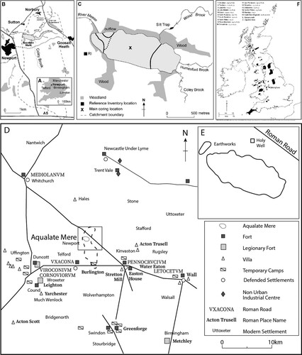
This paper forms part of an investigation that aims to reconstruct Late Holocene environmental changes at Aqualate Mere (AQM) in Staffordshire, Central England (A–C), using an integrated palaeoenvironmental approach. Lowland Staffordshire is a region with few archaeological excavations from prehistoric and Roman sites (Blake, Dean, and Wardle Citation2018) and a limited number of pollen sequences (Dark Citation1999). AQM is well placed to examine the impact of human activities on the landscape as it is surrounded by a range of archaeological monuments including roads, forts and villas, some occupied well into the 4th century AD and with evidence of continuity of settlement from the Iron Age through to the Roman period (Blake, Dean, and Wardle Citation2018) (D). A Roman presence within the catchment of AQM is clearly visible (E). A road to the east of the mere crosses both Wood Brook and Humesford Brook and would have provided the arterial transport route between the Cantonal Capital for Britannia Prima at Deva (Chester) and the large military and urban centre at Letocetvm (Wall) along Watling Street (now the route of the A5). A possible earthwork is located to the west of the mere and a ‘Holy Well’ exists in the north of the Aqualate Hall Deer Park. There are also reports of burials under Ancs Wood – a temporary encampment located in the south of the catchment at Burlington – and numerous fortifications and settlements; for example, at Vxacona (near Telford), Pennocrvcivm (near Cannock), Penkridge and Stretton, the latter both within 15 km of Stafford (Bartley and Morgan Citation1990). In this paper, we use pollen, non-pollen palynomorphs (NPPs), diatoms, geochemistry and mineral magnetic data from AQM to provide evidence of human activity during the last three millennia, and we compare our results with the archaeological and historical records to investigate the impact of prehistoric people and the Romans on the landscape surrounding the lake.
Figure 1. (a) Location of Aqualate Mere (near Newport) in the UK, (b) in the West Midlands of England, and (c) within its catchment; (d) overview of the distribution of the regional archaeology, and (e) the catchment archaeology; (f) position of the fieldsite relative to the major metalliferous orefields of Britain.
Site Description
AQM is a shallow, lowland lake with a water surface area of ca. 0.72 km2 that formed in a kettle hole left by retreating Devensian ice (Pittam, Foster, and Mighall Citation2009). It is a Site of Special Scientific Interest (SSSI) and a National Nature Reserve (NNR). The lake is very shallow and has a mean depth of 1.20 m with a maximum depth of 1.40 m (Pittam 2006). The mere is regarded as internationally important by Natural England in its Geological Conservation Review (Glasser Citation2003; Citation2004). It is situated c. 2 km west of Newport, Staffordshire, UK (A,B). The catchment of AQM encompasses c. 59 km2 of predominantly agricultural land (Hutchinson Citation2005; C). Previous research has focussed on the recent sedimentation history and the identification of sediment sources entering the lake (see Hutchinson Citation2005; Pittam, Foster, and Mighall Citation2009). Notwithstanding the factors that influence pollen recruitment source areas into a lake (e.g. Bonny Citation1976; Jacobson and Bradshaw Citation1981; Sugita Citation1993, Citation1994; Bunting et al. Citation2004; Pittam, Mighall, and Foster Citation2006;) the main sources at Aqualate Mere are from both aerial and hydrological inputs. Three main inflows enter the lake (C) which contribute hydrological in-wash of microfossils, particularly from the eastern side of the catchment into the mere combined with numerous agricultural ditches and brooks that drain the surrounding agricultural land and the outflow from at Norbury Junction on the Shropshire Union canal (Pittam, Foster, and Mighall Citation2009). Numerous studies suggest that streams contribute a substantial amount of pollen (e.g. Bonny Citation1978; Brown, Carpenter, and Walling Citation2007), possibly accounting for between 85 and 93% of the preserved record (Pennington Citation1979) and 92% in a study by Qinghai Xu et al. (Citation2012). Additional sources of pollen include aerial deposition from local and extra local sources (cf. Bonny and Allen Citation1984; Jacobson and Bradshaw Citation1981) and a regional component from airborne pollen. The mere is presently surrounded by managed parkland dominated by grassland, isolated mature oak stands and early nineteenth century AD plantations (C; Yale Citation1994). Isolated coniferous plantations also grow in the catchment. Other land use categories include pasture with small areas of arable agriculture. The local solid geology is Permian-Triassic Old Red Sandstone (Ambrose et al. Citation2020). This underlies coarse-grained superficial deposits largely in the form of outwash gravels and eskers that were deposited during the Devensian glaciation (Glasser Citation2003, 2004). The catchment soils are very diverse with nine soil associations recorded.
Material and Methods
A 5 m core was recovered from AQM using a combination of a 150 × 5 cm Mackereth Corer and a 50 × 5 cm Russian corer (Aaby and Digerfeldt Citation1986). The Mackereth core was extruded in the laboratory at 1 cm intervals using a slicing plate. The Russian cores were transported intact from the field in plastic tubing wrapped in polyethylene. The sediment was stored at 4°C prior to sub-sampling.
Chronology
A chronology for the core was obtained using a combination of radiometric analyses (14C, 137Cs, 210Pb) and Spheroidal Carbonaceous Particles (SCPs), each procedure following routine protocols. Two bulk sediment samples from 475–477 cm and 245–247 cm depth respectively were submitted to Beta Analytic for conventional radiocarbon dating. Dates were calibrated using CALIB 8.20 calibration programme and IntCal20 (Stuiver and Reimer Citation1993; Reimer, Baillie, and Bard Citation2009).
To bridge the gap between 210Pb and 14C dating, SCPs were counted to date recent lake sediments from c. AD 1850 (Rose et al. Citation1995; Shotbolt, Hutchinson, and Thomas Citation2001; Vukic and Appleby Citation2005). The extraction of SCPs followed the method outlined by Rose et al. (Citation1995), and 5% of the final residue was mounted onto fixed microscope slides using Naphrax mountant. The total number of SCPs on each slide were counted and then converted to units of particles per cm3 (Rose et al. Citation1995).
The samples for 137Cs and 210Pb analyses were packed into pre-weighed PTFE sample holders and lightly compressed to provide a sample depth of 40 mm (to match the geometry of the active Ge volume in the well detectors used for analysis; Appleby et al. Citation1986). After reweighing, the sample holders were sealed using Subaseals® and paraffin wax to prevent 222Rn gas escape. All sealed sample holders were then stored for a minimum of 21 days to allow for equilibration of 222Rn with the parent isotope 226Ra. Radionuclide analyses were undertaken using calibrated Hyper-Pure Germanium Well Detectors with count times of typically between 36 and 96 hours. The seven radionuclides measured are described in Pittam, Foster, and Mighall (Citation2009) and further detailed explanations of the methodology and calibration methods are given by Appleby and Oldfield (Citation1978), Foster et al. (Citation2006) and Walling and Foster (Citation2016).
Microfossils
Sub-samples of 0.5–1 cm thickness were prepared for pollen, non-pollen palynomorph (NPPs) and microscopic charcoal analysis (Barber Citation1976). After chemical treatment the residue was mounted in silicone oil for counting. At least 500 land pollen grains were counted for each sub-sample except when pollen preservation was poor, or content was sparse, resulting in a lower pollen sum being accepted in some cases. Pollen was identified with the aid of keys (Fægri, Kaland, and Krzywinski Citation1989; Moore, Webb, and Collinson Citation1991) and modern reference material. The pollen diagrams were drawn using Tilia and Tilia.graph version 2.0.b4 (Grimm Citation1991-1993). Taxa are presented as percentages of total land pollen (TLP), excluding spores and aquatics. As Myrica and Corylus are difficult to separate (Edwards Citation1981), these taxa have been combined as Corylus avellana-type. Cereal-type pollen are classified as grains greater than 37 ųm and with an annulus diameter of more than 8 ųm (Moore, Webb, and Collinson Citation1991; Andersen Citation1979; Beug Citation2004). It should be acknowledged that some wild grasses can be incorporated into this group (Tweddle et al. Citation2005). NPPs were counted during routine pollen analysis and identified using the type system devised by van Geel (e.g. van Geel Citation1978; Citation2005) and are expressed as a percentage of TLP and NPPs. Plant nomenclature follows Stace (Citation1997) and takes into account the problems of categorising plant species on the basis of their pollen morphology (Bennett, Whittington, and Edwards Citation1994). Summary curves for trees, shrubs (constituting arboreal pollen, AP), dwarf shrubs and herbs (non-arboreal pollen, NAP) are shown. Microscopic charcoal was recorded using Clark’s (Citation1982) point count method. Zonation of the pollen diagram was undertaken using CONISS (Grimm Citation1987).
Diatoms were prepared for counting using a H2O2 digestion (Renberg Citation1990) before being air dried and mounted in Naphrax. Samples were counted until a minimum number of 300 diatoms had been achieved for each sample. Taxa are expressed as percentages of the total diatom assemblage (TDA). Identifications were made with the aid of Krammer and Lange-Bertalot (Citation1986; Citation1988; Citation1991a, Citation1991b) and Hartley et al. (1996). Where possible species are classified by their ecological affinities following Denys (Citation1991) and van Dam, Mertens, and Sinkeldam (Citation1994). Zonation of the diatom diagram was undertaken using CONISS (Grimm Citation1987). Diatom preservation was poor in the uppermost 130 cm and were deemed unviable for counting. Samples were analysed every 5 cm between 130 and 490 cm.
Geochemistry
Major and minor elements (Si, Al, Fe, Ti, Ca, Mg, P), trace lithogenic elements (Rb, Sr, Y and Zr), and trace metals (Cu, Mn, Pb, Zn) were determined. Sub-samples were digested in a CEM Mars 5 microwave in a 4:1 solution of concentrated HNO3 and H2O2. Once cooled, samples were filtered, 3 ml LaCl was added, and the sample volume made up to 50 ml with deionised water. Analysis was undertaken in either a Unicam 939 Flame Atomic Absorption Spectrometer (for Pb, Cu and Zn) or by Inductively Coupled Plasma-Atomic Emission Spectrometer using the Perkin Elmer Plasma 400 (for other elements). Digestion of certified reference materials using this procedure showed that extraction efficiencies lay between 93 and 98%; the results reported in this paper have not been corrected for recovery efficiency. Quality controls included the use of replicates and spiked standards, and analytical accuracy was ±3%. Results are expressed on a mass-specific basis as either mg g−1 or μg g−1, depending on the concentration range.
Pb enrichment factors (Pb-EFs) were calculated using Zr as a conservative element using the equation Pb-EFs = (Pbsample/Refsample)/(Pbbackground/Refbackground) (Boës et al. Citation2011). Average upper continental crust concentrations were used for the background ratio as site-specific values derived from deeper pre-pollution sediments levels were unavailable. An upper continental crust value of 193 mg kg−1 for Zr, was used (Rudnick and Gao Citation2003). EFs are taken as indicative of relative changes in Pb content, as we are aware that the indiscriminate use of EFs has been previously criticised (Reimann and de Caritat Citation2000; Kylander et al. Citation2006; Bern, Walton-Day, and Naftz Citation2019). In the case of AQM sediments, the use of Zr as reference element for Pb is supported by the PCA results (see below).
LOI
To examine fluctuations in organic carbon, loss-on-ignition (LOI) analysis was conducted on the sediments between 20 and 210 cm, at 2 cm intervals, following the conventional method outlined in Heiri, Lotter, and Lemcke (Citation2001).
Environmental Magnetism
There are several factors that can influence the magnetic properties of lake sediments, such as: the contribution of eroded soil that externally reflects the magnetic signatures of the soil associations being eroded; the fallout of magnetically enhanced atmospheric pollutants; and the possible post-depositional diagenesis of magnetic minerals, or the formation of new minerals such as authigenic greigite (Walden, Oldfield, and Smith 1999; Walling and Foster Citation2016). Internal lake processes can also alter the magnetic properties of the lake sediment so that they are dominated by these internal processes rather than those reflecting contributions from external catchment or atmospheric sources. The presence of authigenic greigite, for example, can be detected using the ratio of SIRM against χlf with values exceeding ∼20 kA m−1 being indicative of sediments with a greigite signature. A ratio of SIRM to Xlf greater than 2 suggests that magnetic signatures may be overprinted by the presence of bacterial magnetite.
A combination of magnetic susceptibility and remanence parameters were measured and/or derived as part of the analysis of the AQM sediments. Mass-specific magnetic susceptibility and remanence characteristics (Supplementary Table 1) were determined on ∼5–10 ml sub-samples of oven-dried (40°C) sediment sieved to <63 µm and in all cases corrected for loss-on-ignition at 550°C (Foster et al. 1998; Walling and Foster Citation2016). Results are reported on a minerogenic basis because organic matter is usually diamagnetic and dilutes the magnetic signature. Low and high-frequency magnetic susceptibility were measured using a Bartington® MS2 susceptibility meter with an MS2B dual frequency sensor (Dearing Citation1999). Anhysteretic (ARM) and Isothermal (IRM) remanences were measured using a Molspin® rotating magnetometer. ARM was grown with a DC bias field of 40 µT and a peak alternating field of 100 mT in a Molspin a.f. demagnetiser. The ARM values quoted are given as susceptibility of ARM (Χarm) and have been normalised to the strength of the DC field. IRMs were grown in a Molspin pulse magnetiser to a maximum field strength of 880 mT which is probably sufficient to saturate the sample (see Walden, Oldfield, and Smith 1999). Measurement of loss of IRM after 24 h (IRMloss) was taken after samples had been magnetised at the maximum field strength (880 mT). Loss of remanence over time, like frequency dependent susceptibility, is often a function of fine ‘viscous’ grains on the transition from stable single domain to superparamagnetic (Higgitt, Oldfield, and Appleby 1991). Units of measurement and ratio definitions are given in Supplementary Table 1. A more detailed explanation of magnetic measurements and their interpretation is given by Walling and Foster (Citation2016).
Statistical Analysis
Multivariate statistics were used to summarise common patterns of variation within datasets and to gain insights into the underlying environmental factors that control these. Principal Component Analysis (PCA) was applied to the element composition data in correlation mode and by applying a varimax rotation, using SPSS 20. As these are closed data (Aitchinson, Barceló-Vidal, and Pawlowsky-Glahn Citation2002; Baxter et al. Citation2008), a centred log ratio transformation (Aitchinson Citation2003; Baxter and Freestone Citation2006) and standardisation (Eriksson et al. Citation1999) were applied prior to the statistical tests.
Results
Stratigraphy
The stratigraphy () is a broadly homogenous, organic-rich gyttja. At a depth of approximately 1 m, the gyttja is overlain by a unit of clay.
Table 1. Stratigraphy of Aqualate Mere following Troels-Smith’s (Citation1955) classification.
Dating
The chronology is limited by only having two radiocarbon dates with 2σ calibrated age ranges spanning up to 400 years. All calibrated ages are expressed in calendar years BC/AD and are rounded up to the nearest half decade based on estimates from the CLAM age-depth model. However, the cited estimated ages in the text must be treated with caution. Notwithstanding this caveat, the 2σ calibrated range of the radiocarbon date positioned close to the base of the core (4.75 m) suggests that the entire sequence covers the last c. 3000 cal. years (). The initial increase in SCP concentration occurs at a depth of 1.12 m (Pittam, Foster, and Mighall Citation2009) and is dated to the AD 1830s (e.g. Vukic and Appleby Citation2005). In contrast to previous studies, when a single major increase in SCP concentrations has been dated to the early AD 1950s (e.g. Rose et al. Citation1995), two peaks in SCPs occur at 42 and 22 cm depth at AQM. The double peak in the SCP profile has been resolved by supporting dating evidence from the 137Cs profile (see below), which places a depth of 42 cm in the early AD 1950s (see Pittam, Foster, and Mighall Citation2009). The 137Cs profile demonstrates an initial increase in 137Cs activity up-core from a depth of ca. 60 cm, although the long tail of low 137Cs activities below 50 cm depth may be due to post-depositional diffusion through the profile (cf. Foster et al. Citation2006). The increase at 50 cm and peak at 37 cm depth most likely correspond to the initiation of atmospheric weapons fallout in AD 1954 and the AD 1963 fallout peak from atmospheric weapons testing respectively. A further peak, at 20 cm depth, was probably caused by fallout from the Chernobyl nuclear accident in AD 1986. The 210Pb chronology placed the sediment at 58 cm as dating to the beginning of the twentieth century, thus providing a chronological marker that lies between the initial increase in SCP concentrations and the 137Cs profile. The independent chronological markers provided by the 137Cs data appear to match the 210Pb dating very closely. The chronology is also supported by the Pb data presented below. The CLAM software package (Blaauw Citation2010) was used to create an age-depth model (), which combines 14C, SCP, 210Pbun and 137Cs dates, to infer approximate ages for all layers.
Figure 2. Age-depth model (using a smooth spline) for Aqualate Mere using CLAM (after Blaauw Citation2010).
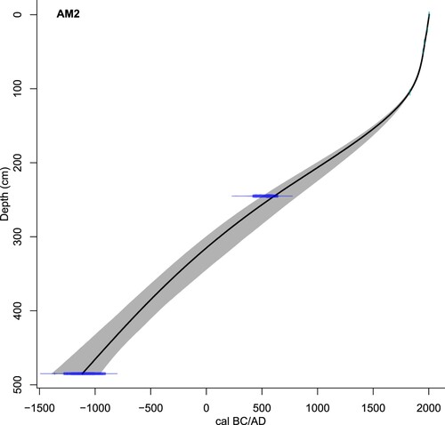
Table 2. Radiocarbon dates from Aqualate Mere (Calibrated using Stuiver, Reimer, and Reimer Citation2021).
Microfossils
A summary of the major changes in the pollen, spores and selected non-pollen palynomorph record are described in that represent various land uses (cf. Brown, Carpenter, and Walling Citation2007). The record (A–C) shows that the AQM catchment contained mixed woodland. Most of the major changes observed in the tree and shrub pollen record involved Quercus, Alnus, Betula and Corylus avellana-type (A).
Figure 3. Percentage pollen diagram for Aqualate Mere by depth. (a) Trees and Shrubs; (b) Dwarf Shrubs and Herbs; (c) Spores, Aquatics and selected non-pollen palynomorphs (NPPs). Stratigraphic column follows Troels-Smith (Citation1955). Upper sediment: Argilla stetodes; lower sediment: Detritus herbosus.
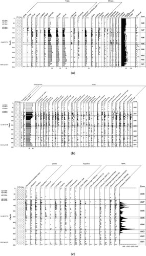
Table 3. Pollen zone descriptions for Aqualate Mere.
Agricultural indicators occur throughout the record. Poaceae is abundant with an increase in values in the upper third of AM6. Cereal-type pollen is more evident from the upper part of zone AM2 as both Secale cereale and Triticum-type remain at higher values until they fade in zone AM8 (B). Each phase of lower tree and shrub pollen is inversely related to increases in non-arboreal pollen and spores with pastoral and disturbance/ruderal affinities (Behre Citation1981; Brown, Carpenter, and Walling Citation2007). Coprophilous fungal spores are also consistently recorded throughout the pollen diagram until zone AM8. The erosion-indicator Glomus cf. fasciculatum (HdV-207) (van Geel 2001) and Valsaria cf variospora (HdV-140) occur in trace amounts whilst the cyanobacterium, Anabaena sp. (HdV-601; van Geel et al. Citation1994), is well represented in zones AM3-7. Other land uses include wet grasslands/meadows suggested by the presence of Cyperaceae, Apiaceae, Filipendula, Ranunculaceae, Rubiaceae, Urtica-type, Sphagnum and Equisetum (Behre Citation1981; Brown, Carpenter, and Walling Citation2007). Aquatic and shoreline taxa, likely to be present in or around the mere fringe, include Nuphar, Nymphaea, Myriophyllum, Potamogeton, Sparganium emersum-type and Typha latifolia. Isoetes occurs less frequently (C).
The diatom record can be divided into five separate assemblage zones (). Broadly, these zones correspond to variations in the relative contributions of planktonic/tychoplanktonic, epontic and benthic taxa. AMD-1 is characterised by a planktonic/tychoplanktonic taxa (c. 60% of the total diatom assemblage [TDA]). The diversity of diatoms in this zone is rather limited with Cyclostephanos dubius, Cyclostephanos costalimbus and Fragilaria construens comprising around 70% TDA. C. dubius expands to between 4 and 55% in AMD-2 heralding a sharp increase in planktonic taxa to 55–65%. The diversity of planktonic forms also increases with a gradual rise in Cyclotella radiosa, Stephanodiscus rotula and Cyclotella bodanica var. affins. These patterns continue into AMD-3 with planktonic and tychoplanktonic taxa comprising >70% TDA throughout the zone, despite a gradual decline in C. dubius. AMD-4 marked a significant shift in the lake ecology as the contribution of plankton and tychoplankton falls to between 40 and 50%. Coupled with this development is a sharp decrease in C. dubius, the gradual decline in taxa such as C. costalimbus, S. rotula and C. bodanica var. affins and the emergence of the species Cyclotella ocellata and Navicula scuttelloides. The emergence of these two species is short-lived and by the beginning of AMD-5 planktonic and tychoplanktonic species dominate the assemblage once again. Nevertheless, the assemblage is somewhat different to previous zones with F. construens dominant and Cocconeis placentula subdominant.
Figure 4. Percentage diatom diagram by depth.
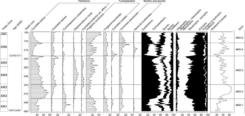
Throughout the analysed section the diatom flora is dominated by species (≥ 80% TDA) with a preference for mesotrophic to eutrophic conditions. At the opening of the analysed sequence (AMD-1) these types are relatively evenly balanced. Into zones AMD-2 and AMD- 3 eutrophic forms represent approximately 55–70% TDA. By AMD-4 and AMD-5 there is a decline in eutrophic diatoms and an expansion of mesotrophic to eutrophic taxa.
Geochemistry
Five Principal Components accounted for 84% of the total variance of the chemical composition of the samples (; Supplementary Figure 1; Supplementary Table 2): Cp1 has large positive (>0.7) loadings of Fe, Si, and Mg, moderate-low (0.38) positive loading of Mn, large negative (<−0.7) loadings of Al and Rb, and moderate-low negative loadings of Zr (−0.53) and Y (−0.32). Cp1 reflects two contrasting mineralogies, since the elements with negative loadings usually occur in larger concentrations in felsic minerals (like K-felspars) and those with positive loadings tend to be enriched (except for Si) in mafic minerals (like amphibole). Cp1 appears to represent fluxes of mineral matter from two different sources. The record of scores shows relatively high (enrichment in Fe, Si, Mg and Mn) but irregular scores in samples older that c. 700 BC, lower and almost stable scores until c. 300 BC, and elevated values until c. AD 300 (in two phases: from c. 300 BC to c. 100 BC, and AD 100–300). An isolated peak occurs at c. AD 1070, another phase of elevated scores between c. AD 1380 to c. 1600, a peak by c. AD 1690, low values until the end of the nineteenth century and a moderate increase during the twentieth century. The pattern broadly resembles that shown by the magnetic susceptibility (Pittam, Foster, and Mighall Citation2009), which is interpreted as reflecting catchment sources with little influence from internal lake processes.
Figure 5. Principal Component Factor Scores (Cp1–Cp5) and Lead (Pb) enrichment values by age for Aqualate Mere. The zones for the pollen and diatoms are shown to facilitate comparisons and main archaeological periods.
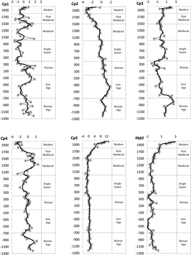
Cp2 has large positive loadings of LOI (i.e. organic matter; also see A) and biophylic elements (P and Mn), and large to moderate negative loadings of Pb and Zr. Although values are low, it is also significant that Si, Rb, Al, which are hosted in the mineral phase, have negative loadings and Ca, which is a biophylic element, has a positive loading on this component. Thus, Cp2 mainly reflects the content of organic versus mineral matter in the sediments and most likely reflects within lake bio-productivity. Most of the P seems to be in organic form, as suggested by this component, and thus it does not reflect fluxes from the catchment.
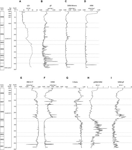
Figure 6. Environmental magnetism measurements by depth for Aqualate Mere.
Cp3 is characterised by large positive loadings of Zn and Y, and a large negative loading of Ti (). Zn may derive from material from the canal located at Norbury Junction in the top metre of the core (Pittam, Foster, and Mighall Citation2009). Thus, this part of this component may be related to fluxes from the canal. This is supported by the abrupt increase in Cp3 scores since the mid-twentieth century. Even though the canal has not made a significant contribution to the sediments accumulated in AQM during the last 45 years (Pittam, Foster, and Mighall Citation2009), it does not mean that the flux cannot be detected. Relatively high positive scores were found in samples with ages between c. 860 and c. 610 cal. BC which are too old to relate them to the canal and therefore must originate from another source (or sources) with a similar chemical composition.
Cp4 is characterised by large positive loadings of Sr and Cu, and a moderate-low negative loading of Mg. This might relate to different soil sources from the catchment. The scores show elevated values for samples with ages older that c. 900 cal. BC, decreasing values by c. 850 cal. BC, almost constant values (around zero) until the beginning of the twelth century, elevated values until mid-seventeenth century and a rapid decline after that ().
Cp5 is characterised by a large positive loading of Ca, and moderate-low negative loadings of Zr and Mg. The most evident change in the record of scores occurs at the beginning of the sixteenth century, when concentrations (mainly Ca) start to increase, accelerating by the beginning of the twentieth century. Increase Ca loadings may reflect lake eutrophication, but the opposite can happen (see Murphy, Hall, and Yesaki Citation1983). Bio-productivity (Cp2) does not follow the increase in Ca fluxes in the upper part of the core, possibly because climatic conditions may have depressed it during the Little Ice Age.
Four major phases of Pb enrichment are recorded in the AQM core (). The PbEF record shows relatively high values: (i) during the Bronze Age through to the transition to the Early Iron Age; (ii) enrichment during the Late Iron Age and the Roman period (with a similar record to Cp1); (iii) a sharp increase during the mid-5th AD, before gradually declining through to the mid-14th AD; (iv) towards the top of the core, where an increase occurs in three steps: the first from the 14th to mid-seventeenth century, the second from the mid-seventeenth century to the beginning of the twentieth century, and the third and most dramatic one since then. Despite the decrease in Pb concentrations (Supplementary Figure 1), the PbEF do not imply lower atmospheric metal pollution. Martínez Cortizas et al. (Citation2012) found a similar situation, probably due to a coal-fired power station (operational in the recent past) replacing other sources of Pb pollution. This may also apply to AQM with the coal-fired power station of Coalbrookdale (approximately 20 km to the south-west of Newport) being operational since 1969.
LOI and Environmental Magnetism
There are three major zones reflecting differences in LOI (A). From the base of the core to ∼250 cm depth when LOI generally exceeds 40%. From 250 cm to 125 cm depth, LOI averages ∼30% and upcore of 125 cm depth, LOI is generally less than 20% upcore. Because of the very high LOI values, all magnetic concentrations reported below are corrected for LOI.
Magnetic susceptibility (B) is highly variable below 3 m depth in the core and the variability diminishes significantly upcore. The upper 3 m of sediment also shows some minor general trends including slightly higher Xlf values in the upper 30 cm and between 75 and 125 cm depth. The low values below 1 × 10⁻⁶ m3 kg−1 suggest that significant quantities of ferrimagnetic minerals are probably not present in these sediments (Dearing 1999).
IRM880mT (C) shows broad trends similar to those of Xlf but with significantly less variability below 3 m depth in the core while ARM values (D) only show a significant increase in the upper ∼25 cm of the entire sequence. Of note is the trend in the S ratio (G) which shows three distinct zones, two with a ‘soft’ remanence with S ratios over 0.8 (0- 80 cm depth and below 275 cm depth) and a ‘harder’ remanence with lower S ratios in the central portion of the core. The χARM:IRM 880mT ratio (H) exceeds 2 between ∼ 300 and 375 cm depth and increases towards 2 in the upper 25 cm of the core whilst the SIRM:Xlf ratio (I) generally remains below 20.
Discussion
Land Use Changes During the Bronze and Iron Age
There is some known prehistoric archaeology surrounding AQM and recorded across Staffordshire and Shropshire more generally, particularly contemporary material culture, including Bronze Age burnt mounds and cremation cemeteries (Hurst Citation2011). The AQM pollen record provides evidence for human impact during the mid to late Bronze Age, characterised as short-lived clearances interspersed with periods of woodland recovery (Zones AM1 and 2; c. 1310–700 cal. BC; Figures 3A,B). Even when the arboreal pollen (trees and shrubs) record suggests a period of woodland regeneration, and evidence for human activity diminished, it did not dissipate altogether. Percentages of pastoral and disturbance indicators fall but many are present throughout this time in trace amounts. Arable agriculture also continues, possibly uninterrupted, as cereal-type pollen is recorded. This supports Dark’s (Citation1999) assertion that cultivation was already widespread in Iron Age Britain.
Low arboreal pollen percentages between 490 and 480 cm (c. 1115–1085 cal. BC) and 460 and 450 cm (c. 965–905 cal. BC) are suggestive of short-lived woodland clearances. Cereal-type pollen, including Secale cereale (rye), provides evidence of cultivation while pastoral and disturbance/ruderal indicators and coprophilous fungal spores, that are indicative of grazing, are also regularly recorded (B,C; Brown, Carpenter, and Walling Citation2007; Perrotti and Van Asperen Citation2019). Finds of Secale cereale are rare in the Bronze Age and may be possibly intrusive weeds rather than the result of cultivation (Barclay and Fairweather Citation1984; Boyd Citation1986). Secale cereale pollen grains do occur from the second millennium BC in British peat and lake sediments and some seeds recovered from LBA contexts mean that it could have been used as a fodder, food grain or other type of crop (Chambers and Jones Citation1984; Chambers Citation1989). The percentages of Secale found at AQM exceed 1% TLP, a value taken by some as indicative of cultivation, but the criteria for a 1% threshold to differentiate between weed and crop rye is not clearly established (Chambers Citation1989). Its occurrence at AQM, alongside pollen from Triticum/Avena-type (wheat/oats) and Hordeum-type (barley) (B), does not exclude the possibility that rye was wild amongst those crops. Given the regular presence of rye pollen at AQM extends back into late prehistoric times, the contention that domesticated rye was introduced by the Romans is not supported here. Although the reason for this is unclear, rye seemingly became an important crop at AQM, a feature also recorded in Denmark and the Low Countries during the first millennium AD (Chambers Citation1989).
The second phase of woodland clearance is coincident with an increase in Cp1 reflecting a change in the source of mineral material entering the mere (). The amount of degraded, corroded and broken pollen grains also increases slightly, typical of fluvial transport (cf. Cushing Citation1967), and LOI values are lower. Although there are no archaeological records of Bronze Age activity within the immediate vicinity of AQM (Wardle Citation2003), there is a small cluster of findspots located along the A5 Watling Street to the immediate south and a single round barrow at the source of the River Penk. Evidence of woodland clearance and agriculture is also shown in the pollen record at King's Pool in Stafford (Bartley and Morgan Citation1990). Rowley (Citation1971, 31) has suggested ‘lowland settlement during the Bronze and Iron Ages was far more important that had previously been thought’, and the AQM microfossil record lends some support to this assertion.
Woodland regeneration occurred during the Bronze Age throughout Staffordshire and Shropshire as a response to reduced human activity although the nature of the regeneration differs from site to site (e.g. Beales Citation1980; Twigger Citation1988). At AQM it occurs between c. 905 and 700 cal. BC (450–414 cm: A). This may have been a product of what Darvil (Citation1987, 75) termed ‘social discontinuity in the south’. This occurred as far north as the English Midlands manifesting itself as settlement abandonment, woodland regeneration (e.g. Dark Citation2006) and the development of scrub grassland (e.g. Sims Citation1978). Woodland recovery occurred at AQM and the pollen evidence suggests that while human activity diminished, especially midway through zone AM1 and during the first half of zone AM2 (Figures 3A,B), agriculture appears to have continued. Woodland regeneration, a concordant decline in cereal production and possible land abandonment, especially in the British uplands, around the time of the Bronze Age/Iron Age transition continues to be debated (Amesbury et al. Citation2008; Davies Citation2007; Dark Citation2006; Armit et al. Citation2014; Stevens and Fuller Citation2015; Bevan et al. Citation2017), and a shift to a colder and/or wetter climate (e.g. Barber, Chambers, and Maddy Citation2003), attributed to a decline in solar activity (van Geel, Buurman, and Waterbolk Citation1996a), may have been influential. While weaker chronological resolution and plateaux in the radiocarbon calibration curve hampers the precision of palaeoecological records at AQM at this time, the age-depth model suggests that the ‘850 cal. BC climatic shift’ may have been coincident with the phase of woodland regeneration based on an increase in arboreal pollen (c. 440–441 cm, a). Any increase in the soil moisture content at AQM would have also encouraged carr woodland and waterlogging by raised groundwater levels in low lying areas of the catchment (cf. Yates Citation1999; Macklin, Johnstone, and Lewin Citation2005; van Geel, Buurman, and Waterbolk Citation1996a) which could have in part facilitated a downturn in agricultural activity surrounding AQM. More pragmatically, Twigger (Citation1988, 751) proposes that the reduction in agricultural indicators is due to the ‘shift in farming activity away from land close to the meres’. Irrespective of the cause of any downturn, soil erosion continues in the AQM catchment based on the magnetic measurements and geochemistry: several short-lived ‘spikes’ in χlf, SIRMminero and ARM, IRM – 0.1 T, HIRM and the S ratio (Pittam, Foster, and Mighall Citation2009; ), and an increase in the concentration of, or a short-lived peak in, lithogenic elements (Cp1, dip in Cp2 and peak in Cp3 scores () largely driven by increases in Zr, Y, Al, and subsequently Si and Ti; Supplementary Figure 1).
The diatom flora indicates a major shift to eutrophic conditions occurs at c. 790 cal. BC (; 430 cm and 7). Cyclostephanos dubius and Stephanodiscus rotula values increase, followed by Cyclotella radiosa. Abundant Cyclostephanos dubius has been often used to infer eutrophic conditions in lakes (e.g. Gaillard et al. Citation1991) although this association is not always observed (e.g. Sayer Citation2001). Whilst indicative of eutrophic conditions, the abundance of C. dubius may be due to a mixing regime in the relatively shallow AQM that favours its growth as well as light availability, nutrient recycling and biotic interactions (Bradshaw and Anderson Citation2003). The reason for the sudden shift to more eutrophic conditions is not clear but it does occur after the phase of Bronze Age cultivation and before the major increase in cereal pollen. The diatom shift also lags an increase in P concentrations, thus the pattern may indicate a delayed response to increased nutrient loading into the mere (). Nutrient inwashing associated with eutrophication has been observed in English lake sediment records from the Bronze Age onwards (e.g. Fritz Citation1989; Bartley and Morgan Citation1990). However, total P concentrations may not be a reliable indicator of past nutrient loading (Smol Citation2002). Cp2 () suggests that most of the P in the sediments of Aqualate Mere is in an organic form and therefore not necessarily reflecting past P loads but P fixation by within lake bio-productivity.
The transition between the Late Bronze Age and Early Iron Age is not clearly defined in the west midlands of England, partly due to the difficulties with the radiocarbon calibration curve between 800 and 400 BC (Hurst Citation2011). Phases of woodland clearance interrupted by regeneration continued in the later prehistoric period surrounding AQM, but the local landscape remains well wooded based on the relatively high arboreal pollen percentages until the present day as shown by the extent of woodland around the mere today (Figure 1C). A disturbance phase occurs in the upper part of zone AM2 and into AM3 c. 660–535 cal. BC (from c. 410 cm: A,B). The decline in mainly Betula, Alnus and Corylus-avellana-type pollen coincides with a period of agricultural intensification as cereal-type pollen increases rapidly to 5–6% TLP (B) and coincides with a shift in the Cp 1 scores (). Scores shift from negative to positive values, suggesting the variation of fluxes from parts of the catchment with a more felsic to more mafic mineralogy. Pastoral pollen indicators also increase, and coprophilous fungi are consistently recorded. A small spike in Anabaena sp. also was recorded at c. 535 cal. BC (390 cm; C), which may indicate increased nutrient loading derived from agricultural activities and/or from weathering of P-rich bedrock. van Geel et al. (Citation1994; Citation1996b) suggested that intensification of farming and land fertilisation had a similar effect on the trophic conditions of Lake Gosciaz in Poland. The increased occurrence of Valsaria variospora (HdV-140) is also indicative of wet, eutrophic conditions (van Geel et al. Citation2003). Increased P concentrations commence from approximately c. 850 cal. BC (441 cm; Supplementary Figure 1) until 200 cal. BC (342 cm). However, there is a lag between the rise in P and increased Anabaena sp. Cyclostephanos dubius and Cyclotella radiosa are also well represented, and Stephanodiscus rotula increases in value (). This strongly suggests that arable agriculture is possibly driving nutrient enrichment as pastoral and disturbance indicators including coprophilous fungi are more subdued except for Rumex acetosella at this time (B).
Evidence for bacterial magnetosomes is shown in the downcore variations in the χarm:SIRM ratio (between 370 and 300 cm; 400 cal. BC – cal. AD 120) with the occasional spike to 250 cm (cal. AD560; H and ). Oldfield, Appleby, and Van der Post (Citation1999) used this ratio to detect the presence of bacterial magnetosomes: ratios must exceed 2 × 10³ A m−1 to be strongly indicative of their presence. Although they are not considered to be a major influence on magnetic signatures for most of the mere sediment record, especially in the upper 1.3 m, their presence at this time also points to strong enough eutrophic conditions to promote their formation.
Figure 7. Environmental synthesis of selected proxies showing the key trends including from left to right: Pollen zones based on TLP%; Cultural periods; Lithology; Age, Depth; Loss-on-ignition [LOI], χARM/SIRM; Diatoms, Anthropogenic pollen indicators; Ratio of tree, shrub, dwarf shrub and herb pollen; Principal Component Cp1 and Lead (Pb) enrichment.
![Figure 7. Environmental synthesis of selected proxies showing the key trends including from left to right: Pollen zones based on TLP%; Cultural periods; Lithology; Age, Depth; Loss-on-ignition [LOI], χARM/SIRM; Diatoms, Anthropogenic pollen indicators; Ratio of tree, shrub, dwarf shrub and herb pollen; Principal Component Cp1 and Lead (Pb) enrichment.](/cms/asset/aa3f9b4d-7609-476a-b677-e9978d183466/yenv_a_2187520_f0007_ob.jpg)
While archaeological remains ( such as hillforts, burial sites, pottery and metalwork finds) are more abundant to the west and south, the intensively farmed landscape at AQM seems typical of the English midlands during the Iron Age (Hurst Citation2011) and commensurate with evidence of enclosures and lowland farmsteads that have been discovered elsewhere in Staffordshire (e.g. Smith Citation1979). Evidence for agricultural activity and woodland disturbance at AQM is also consistent with changes taking place elsewhere in the region. Extensive clearance occurred on the terraces of the lower Severn valley and floodplain of the Avon valley in Warwickshire and Worcestershire by the MBA and during the Iron Age (Brown Citation1982; Brown and Barber Citation1985). At Fenemere and Baschurch Pool, Shropshire, Twigger and Haslam (Citation1991; 749) state that ‘the small-scale clearance and regeneration […] gave way to more widespread woodland clearance at 800 BC’ which may tentatively indicate the expansion of human activity. The pollen record from Featherbed Moss in Derbyshire shows woodland clearance from the Iron Age with open land from at least c. 170 cal. BC to c. cal. AD 90 (Tallis and Switsur Citation1973) and at a nearby site to AQM, Crose Mere, Shropshire, Beales (Citation1980) shows much of the woodland was cleared by the early Bronze Age, with regeneration occurring during the early Iron Age before renewed clearance in the latter stages of the Iron Age peaking between c. 360 cal. BC to cal. AD 80.
Another phase of woodland clearance at AQM took place c. 200 cal. BC (c. 341 cm; zone AM4; A). The later Iron Age marked a time of further agricultural intensification at AQM. Increased cereal-type pollen is recorded c. 190 cal. BC. The proportion of degraded, broken, and corroded pollen is indicative of increased deposition of secondary, reworked pollen (A) and increasing lithogenic elements (suggested by a peak in Cp1; ) indicate that agricultural activities were intense enough for soil erosion (cf. Silva-Sánchez et al. Citation2014) but Rb, Al and Ti all decline (Supplementary Figure 1). The variation in the response of the lithogenic elements here and elsewhere in the sequence probably reflects the varied nature of both the bedrock and the catchment soils (cf. Martínez-Cortizas et al. Citation2005) and the data here warn against over-reliance of using one or two lithogenic elements as a proxy for soil erosion (e.g. Hölzer and Hölzer Citation1998; Lomas-Clarke and Barber Citation2020). Despite this activity the diatoms suggest that the mere became more mesotrophic: Cyclostephanos dubius and Cyclotella radiosa decrease (although Stephanodiscus rotula increases) and by 310 cm (c. cal. AD 40; ) S. rotula decline as Fragilaria constrens and F. brevistrata increase. P concentrations also decline.
Roman Period
Following a brief period of woodland regeneration starting at c.115 cal. BC (330 cm; A and ), also seen at Crose Mere and Baschurch Pools (Beales Citation1980; Barber and Twigger Citation1987) but not at Stafford (Bartley and Morgan Citation1990) at this time, renewed clearance commenced c. AD 160 and 525 at AQM (between 298 and 254 cm; A) and following a short-lived recovery continued into the early Medieval/Anglo Saxon period (c. AD 755) as the trends described for the end of the Iron Age continue. Evidence for soil erosion persists as the minerogenic content of the mere sediment changes (with an increase in SIRMminero, HIRM, SIRM/χlf, and IRM-0.1 T, and a decrease in the S ratio and χARM/SIRM (H). These changes coincide with an increase in the mafic dominated material and concentrations of the lithogenic elements (Cp1 and Cp2; ), particularly Si, Rb, Zr, Y and Al (Supplementary Figure 1). LOI values decreased from 55% at 281 cm to 29% at 231 cm. Glomus cf. fasciculatum (HdV-207) shows a series of small peaks until c. 240 cm (C). Pastoral indicators are regularly recorded at low values suggesting animal rearing continued alongside cereal cultivation.
Studies conducted in lowland Staffordshire suggest that significant areas of woodland had been cleared before the Romans arrived (e.g. Leah et al. Citation1998; Ciaraldi Citation2002; Stevens Citation2008). As with most areas of Roman Britain, the period is characterised by woodland clearance and crop cultivation (Dark Citation1999) despite the abandonment of some forts in the county by the early 2nd century AD in Staffordshire but not all e.g. Penkridge and Rocester which lasted until the 4th century AD (Blake, Dean, and Wardle Citation2018). The main crops grown were spelt wheat (Triticum spelta), barley (Hordeum vulgare), with bread wheat (Triticum aestivum), rye (Secale cereale) and oats (Avena sativa) and, notwithstanding the difficulty in identifying cereal species in pollen records, cereal pollen is well represented at AQM (). Visible cropmark evidence along with extensive enclosures and associated farmsteads or settlements are found across lowland areas in Staffordshire with evidence for both animal rearing and crop cultivation and is compatible with evidence from AQM.
Although the chronology at AQM remains too imprecise to confirm the precise timing of initial Roman impacts (e.g. Dumayne-Peaty and Barber Citation1997), others (e.g. Dark Citation2005) have shown that the influx of Roman garrisons into Britain led to woodland clearances to provide agricultural land to supply the expanding migrant population: thus, the period is mostly marked by agricultural intensification and deforestation (Oldfield et al. Citation2003; Esmonde Cleary Citation2011). At some sites, such as the landscape close to Crose Mere, remained well-wooded but cereal cultivation appears to have continued locally during Roman times (Beales Citation1980). At AQM, rye becomes increasingly dominant as woodland clearance, especially a reduction of Quercus, continues from c. cal. AD 120 (300 cm, B and ). The continued high cereal pollen values indicate the importance of producing food as the influx of the Roman Army and its retinue, combined with a larger resident population, would have resulted in significant increases in demand. Darvill (Citation1987) estimates that the population reached five million in Britain during the first and second century AD as a product of the increased political stability and the formation of a market economy. Even if local demand was satisfied, AQM may also have been within a resource procurement zone to supply and service military garrisons to the west and north of the region (Esmonde Cleary Citation2011) as most of the newly intensive agricultural systems have been found to be located close to centres of Vici and forts. The Sites and Monuments Record (https://www.staffordshire.gov.uk/environment/Environment-and-countryside/HistoricEnvironment/Overview.aspx) indicates significant Roman military and domestic presence in the region with 61 forts built to suppress the native tribes of the Cornovii, Corielsolilii, Ordovices and Deceangli, with an additional 236 Roman find spots recorded. Wardle (Citation2003) speculates these could be sites of villas. Glimpses of Romanisation on the agricultural landscape of Staffordshire and Shropshire include extensive field systems and agricultural buildings that were discovered near Wall, Staffordshire.
Early Medieval Period
Typically, the 4th century AD (commencing around 280 cm at AQM) was a period of diminishing Roman influence in England culminating in the withdrawal of the army. As Staffordshire is essentially rural in character, Blake, Dean, and Wardle (Citation2018) suggest that it was largely unaffected by the end of the Roman administration. The impact of the Romans began to decrease in the late third century AD as the removal of large garrisons lowered the population and thus requirements for cereal production. At the same time there was reported widespread disturbance within the countryside; the removal of the political and economic stability of the occupation reduced the structured Roman markets developed to trade surplus goods (Wacher Citation2001). Thus, it has been suggested that the end of the Romano-British period was characterised by the widespread abandonment of cultivated fields, possibly in the form of woodland regeneration, or the conversion to a stronger pasture-based agricultural system (e.g. Dark Citation2005). The evidence for this is less forthcoming at AQM as the microfossil data suggests agriculture continued despite a small decrease in total cereal pollen in the uppermost part of zone AM4 (B) and lower Cp1 factor scores (). Evidence for diminished agricultural activity is not seen in the record from King's Pool, Stafford (Bartley and Morgan Citation1990), further supporting the idea that parts of Staffordshire were still exploited for agricultural purposes throughout the Iron Age into the post-Roman period (Blake, Dean, and Wardle Citation2018). Rye, barley and, to a lesser extent, wheat production continued at AQM (B). Lower Quercus pollen percentages between c. AD 430 (264 cm) and c. AD 760 (230 cm; A) are suggestive of the exploitation of oak. Dark (Citation2005) cites dendrochronological evidence for the removal of woodland from across Britain during this period. Slightly increased contributions from Corylus avellana-type and Betula pollen at AQM suggest that the early post-Roman period was possibly characterised by more secondary woodland but there is no evidence for major woodland clearance, except for Quercus. Agriculture appears to drive changes in the lake sediments properties reflected in the magnetic measurements: SIRMminero, HIRM, SIRM/χlf increased and IRM-0.1 T, S ratio and XARM/SIRM decreased. Cp1 factor scores increase ( and ), suggesting that soil erosion continued. Both cultivation and pasture continued: cereal-type pollen percentages fluctuate between 5 and 7% TLP until 226 cm, c. cal. AD 800 and pastoral and ruderal taxa are also recorded in the AQM pollen diagram (B), suggesting that a mixed agrarian economy continued into the Anglo-Saxon period with little evidence of any major disruption (cf. Losco-Bradley and Kinsley Citation2002).
Agricultural activities continued as the mere became less eutrophic following a short-lived phase between 250 and 240 cm (cal. AD 560–660). Cyclostephanos dubius and Cyclotella radiosa values decline sharply with Stephanodiscus rotula and Cyclotella bodanica var. affins values indicative of more mesotrophic to eutrophic conditions ( and ). These changes coincide with a sustained increase in Fragilaria construens and a short-lived rise in Cyclotella ocellata. Anabaena sp. percentages are low as the diatoms indicative of eutrophic conditions return to numbers last seen in the Bronze Age. Other possible factors could explain these trends including grazing by benthic invertebrates which can affect Cyclostephanos dubius and Stephanodiscus species and/or NO2 and NO3 concentrations and light conditions (Bradshaw and Anderson Citation2003).
Notwithstanding the occasional recovery, a slight downturn in cereal cultivation and some indicators of agriculture in the non-arboreal pollen record occurred from c. AD 800 (226 cm; B). This may be due to the reversion to a more subsistence based economy and smaller population. The pollen record sees an increase in Quercus and Pinus with a slight fall in Betula percentages (A). A reduction in agriculture probably led to oak regeneration and increased pine. Less minerogenic sediment (falling Cp1 factor scores) entered the lake. However, by the Norman Conquest a sizeable mixed agrarian economy existed: cereal pollen, including rye and wheat, was at approximately 6% TLP at AQM (B and ). The density of plough lands within the county suggests that the area around AQM was intensively cultivated and possibly heavily populated. Assuming the chronology is robust enough to encompass the Norman Conquest, the AQM pollen sequence should be comparable with land use recorded in the Domesday Book (1086 roughly equates to c. 198 cm; A–C). There are numerical records of land directly related to Aqualate Mere and its catchment, encompassed in the Cuttle stone Hundred, a major regional subdivision for the survey. Meretown, the nearest administrative unit to the mere itself, is recorded as such:
{In CUTTLESTONE Hundred}
MERE(TOWN). Earl Algar held it. 4 hides, with its dependencies. Land for 10 plough. In lordship 1; 2 slaves;
18 villagers with 10. ploughs,
A mill at 3s; 4000 eels; woodland ½ league long and 2 furlongs wide. Value before 1066 £4; now 10s more
The Domesday Book, translated by Morris (Citation1976)
The final major decrease in arboreal pollen (trees and shrubs) commenced at c. AD 1265 (180 cm; A), halfway through zone AM6 and, notwithstanding the occasional reversal, continued to fall until c. AD 1550 (148 cm), coincident with the AM6/7 zone boundary. The decline in woodland at the time of early Monastic activity appears to be due to felling that occurred during the medieval period in the centuries preceding the Domesday Survey (Hoskins Citation1975). Quercus and Betula percentages are most affected from approximately 182 cm to 142 cm (AD 1600; A). Rackham (Citation1986; 88) states that woodland was to shrink from a coverage of 15% of England in AD 1086 to perhaps 10% by AD 1350, although documentary records that cover this period are scarce and often fragmentary owing to the unmanaged nature of the woodland removal. Similar impacts are also recorded in pollen diagrams elsewhere in England (e.g. Oldfield et al. Citation2003). In common with previous phases of woodland clearance, pastoral and disturbance indicators are recorded in increased percentages at AQM and cereal-type pollen is also present. This phase of deforestation and agriculture caused a short-lived shift in the diatoms suggesting an increase in eutrophic conditions seen by increased amounts of Cyclostephanos dubuis ().
Occasional short-lived periods of woodland regeneration occur throughout the gradual decline of woodland in the latter half of zone AM6 (A). These probably represent small fluctuations in agricultural regimes and periods of woodland regeneration caused deliberately and/or naturally possibly exacerbated by changes in climate and possible outbreaks of disease. The Black Death pandemic occurred in Britain between AD 1348 and 1350 and this has been linked to declines in cereal production, the area under pasture, and to reforestation recorded in pollen diagrams with robust chronologies (decadal-scale precision) and high palynological resolution (Yeloff and van Geel Citation2007). Cereal cultivation does not appear to cease at AQM (approximately 171 cm), c. AD 1350 (B) but the lack of a more precise chronology prohibits any attempt to identify short-lived changes in the pollen record. Cereal cultivation possibly occurred close to the start of the plague and there appear to have been no long-term changes, possibly because the local population was not as devastated as reported elsewhere in England and there was sufficient manpower to continue farming (cf. Yeloff and van Geel Citation2007).
Post Medieval Period
The amount of woodland was at its lowest point since the Bronze Age by c. cal. AD 1520 (A; 152 cm), as suggested by total arboreal pollen percentages falling to under 30%. This corresponds with an increase in the concentration of lithogenic elements and a gradual increase in Ti (Supplementary Figure 1). This represents a period of accelerated soil erosion marked by increase abundance in secondary, reworked pollen (A). There is no evidence of an intensification of agriculture as taxa associated with arable and pastoral agricultural remain well represented but do not increase in value, except Poaceae. This might explain the continued shift in the diatoms indicating mesotrophic to eutrophic conditions highlighted by the rise of Fragilaria construens and the decline of Cyclostephanos dubuis ( and ).
Woodland regeneration begins from c. cal AD 1685 (130 cm; A). This coincides with a staggered decline in the concentration of the lithogenic elements indicating a reduction in soil erosion (cf. Martínez-Cortizas et al. Citation2005). A downturn in agricultural activity takes place c. AD 1750 (120 cm; B) characterised by a dip in Poaceae, a decline in cereal-type pollen and the last occurrence of a suite of coprophilous fungi which suggests that grazing was probably taking place in the catchment but not close to the mere fringe. Grassland, arable and pasture remain the dominant land use during the late eighteenth and early nineteenth century (B). Increased pasture is indicated by the peak in Poaceae and increased Plantago lanceolata at 104 cm. Other pastoral indicators are also well represented in the non-arboreal pollen record. Grassland expanded from the 1960s (42 cm) as Poaceae increases to 45%: this may reflect parkland surrounding the mere although arable cultivation continually occurs throughout the twentieth century and the presence of pasture is indicated by a suite of herbaceous taxa. There is a slow decline in cereal pollen from the start of zone AM8, but this may be due to taphonomic factors having an influence on the pollen assemblage, including the change in stratigraphy from gyjtta to clay at 100 cm depth (Pittam, Foster, and Mighall Citation2009).
The increased representation of newly planted trees would also dilute the cereal pollen signal and the plantation of woodland immediately to the north of the mere may have acted as a barrier to cereal pollen dispersal (Maguire Citation1983). Trees were planted around AQM during the early nineteenth century as part of a landscaping scheme (Yale Citation1994) and the increases in total tree pollen coincides with higher SCP concentrations at 105 cm dating to the AD 1830s. These changes are reflected in the pollen diagram. From c. 120 cm (post-AD 1750), Pinus, Picea, Ulmus, Fagus and Cedrus feature more prominently in the pollen diagram. The mixture of trees planted from AD 1805–10 was documented as both semi-mature and whips (except for pine). Parkland records reveal that pine whips were planted with at least 10000 ornamental and fruit trees. Reports from the Deer Park in AD 1810 suggest that there was, ‘considerable activity … with teams moving soil into the garden’ (Yale Citation1994; 36). The resultant instability within the catchment soils and subsequent erosion is detectable within the mineral magnetic signatures of the mere sediment (e.g. χlf and LOI trends in zone AM7). The S ratio declined from 115 cm to 108 cm reaching a minimum of 0.480 before recovering as part of the general increases seen in all the magnetic parameters from 102 cm upwards. Local historical maps show no, or negligible, alteration in the extent of woodland within the immediate vicinity of the mere. The only major alteration in the past century has been the planting of Castle Wood, a small area of woodland some 200 m to the south of the mere, which is not present on Ordnance Survey maps from 1892. This planting may account for the increase in total arboreal pollen percentages including Picea and Ulmus throughout zone AM8 (ca. AD 1874–2004).
Reconstructing Metal Contamination: Prehistoric Times
The source of the relatively high (albeit declining) Pb EF at the base of the AQM record, c. 1200–910 cal. BC is uncertain ( and ). There is no firm archaeological evidence for lead mining or metallurgy locally, although Shaw (Citation2009) suggests that Bronze Age copper and lead mining might have taken place at Llanymynech, which is located on the Shropshire\Wales border (F). Lead was in circulation at this time: it was being intentionally alloyed with copper and tin to produce bronze by the Middle-Late Bronze Age during the Wilburton-Wallington Phase (1140–1020 cal. BC) (Tylecote Citation1986; Rohl and Needham Citation1998). Small pieces of lead have also been found on late Bronze Age occupation sites (e.g. Needham and Hook Citation1988). However, the precise sources of this lead, including that recorded at AQM, remain speculative (Barber Citation2003). While the elevated Pb EF at AQM also correspond to peaks in the same between c. 1100 and 800 cal. BC in a speleothem record at Charterhouse on the Mendips (McFarlane, Lundberg, and Neff Citation2014), it is difficult to envisage sufficient lead production during the Bronze Age to create significant pollution on a regional scale. Bronze artefacts, including axes, palstaves and trunnions, etc, have been found scattered throughout Shropshire, and casting moulds for tools and weapons dating back to the EBA are also known, e.g. the Whalleybourne mould (Shaw Citation2009), yet these do not provide firm evidence of an early insular lead industry more local to AQM.
Late Iron Age-Roman Times
Compared to the early part of the Iron Age, Pb EF increase during the late Iron Age and Roman period (c. 265 cal. BC to AD 285) but values are not pronounced when compared to the EF values from the Bronze Age to the late Medieval period (Figure 5). Studies across Europe have shown that the most widespread pollution phase in ancient times is related to mining and metallurgy by Late Iron Age cultures such as the Phoenicians, Carthaginians, and the Greek and Roman Empires (e.g. De Vleeschouwer, Le Roux, and Shotyk Citation2010). The general trend commenced c. 1000–500 BC, peaked by the 1st–2nd centuries AD and collapsed by c. cal. AD 400. This is the case for Sweden, Britain, Germany, France and Switzerland (Martínez-Cortizas et al. Citation2013). In some regions, this chronology is so consistent that it has been suggested that it can be used as a chronological marker (Renberg, Bindler, and Brännvall Citation2001). This general pattern is also seen at AQM with Pb EF increasing from c. 325 cal. BC (at 359 cm) to a small peak at c. cal. 120 BC (331 cm). Three further peaks at c. 30 cal. BC, c. cal. AD 190 and c. cal. AD 270 (282 cm) are recorded. Thereafter values decline implying the cessation of any mining and metallurgical activities sometime between c. cal. AD 280 and AD 340 (274 cm) ( and ).
The exact source of the deposited lead at AQM is unknown. A regional anthropogenic source is more likely than a local one. There is evidence for lead working at some sites such as Wall but it is unlikely to have been on a scale to generate widespread pollution. There is no evidence that the Romans exploited copper at Ecton (Blake, Dean, and Wardle Citation2018). On a wider scale, Iberia and Britain were the two major metal producing areas in Western Europe, and both Tacitus and Pliny mention the exploitation of British argentiferous lead deposits (Jones and Mattingly 1990). Even though Roman lead mining was more extensive in Iberia (e.g. López-Merino et al. Citation2014), potentially making this the dominant regional source for lead pollution in western Europe, the isotopic signature of lead contamination recorded in a peat profile at Lindow Bog, Cheshire, suggests a British source is more likely in this case (Le Roux et al. Citation2004). There are several major British lead mining areas surrounding AQM: these include north-east Wales, Shropshire to the southwest of AQM and Derbyshire to the northeast. Orefields in central Wales, the Mendips and SW Gwent are more distant to the south-west (F). Given the predominantly SW to NE prevailing wind direction, these orefields are likely pollution sources. The closest, Shropshire, has at least 317 known abandoned lead mines (Davies and White Citation1981) with Roman lead pigs discovered at three of them (Shaw Citation2009). Dated ingots confirm that lead was mined from the Mendips by AD 49, the Flintshire mines of NE Wales by AD 74 and Nidderdale mines in Yorkshire by AD 81 (Jones and Mattingly 1990). Unequivocal archaeological evidence for mining is less forthcoming across the Shropshire and Welsh orefields (e.g. Jones et al. Citation2004). Roman lead smelting sites have been discovered in the Ystywth valley and Llancynfelin, near Aberystwyth (Timberlake Citation2002). Evidence for metal processing during the 1st century AD onwards has been identified in north-east Wales with the discovery of lead pigs (Jones et al. Citation2004). Roman mining did take place at Charterhouse on Mendip and at Alderley Edge in Cheshire (Todd Citation1996, Timberlake and Prag Citation2005), suggesting that local British sources contributed to the pollution recorded in bogs across Britain. Total lead production has been estimated at approximately 100,000 tons in the Mendips Orefield (McFarlane, Lundberg, and Neff Citation2014). McFarlane, Lundberg, and Neff (Citation2014) consider Roman smelting to have been inefficient, citing Morgan’s (Citation1900) estimate that approximately 10% of lead used for smelting was volatised into the atmosphere. Subsequent experiments suggest this could be far higher (e.g., Baron et al. Citation2009). This is corroborated by increased lead concentrations in a speleothem record from Charterhouse which shows a distinct peak in lead from 350 BC to AD 1 and increased concentrations during the Roman era (McFarlane, Lundberg, and Neff Citation2014). Peat records also record lead pollution during the Roman period in central Wales (Mighall et al. Citation2002, Citation2009), in north-west England (Le Roux et al. Citation2004) and in Scotland (e.g. Cloy et al. Citation2005; Küttner et al. Citation2014). It is surprising that an elevated Pb EF is not recorded at AQM. The pattern corresponds to Cp1 between the Bronze Age and the post-Medieval period, suggesting that the Pb EF is responding to a catchment-related process rather than providing a record of the anthropogenic Pb pollution.
Cu and Sr, which began to increase at 204 cm (c. cal. AD 985), continue to rise thereafter and remain at higher values until 130 cm (Supplementary Figure 1). The pattern of copper concentrations is similar to the lithogenic elements and therefore is probably derived from catchment soils rather than pollution from metallurgical activities. Roman copper mining occurred at Llanymynech on the Welsh/Shropshire border but there is no evidence for any medieval workings (Jones and Mattingly Citation1990). Copper concentrations during the Roman period are not elevated relative the rest of the profile at AQM and they remain much lower than those recorded during the medieval period.
Anglo Saxon
Between c. cal. AD 340 and c. cal. AD 525 (274–254 cm) Pb EF values are much lower ( and ). They recover to slightly higher values, albeit much lower than those recorded during Roman times, possibly suggesting a small revival in lead mining and/or metallurgy by c. cal. AD 660 (240 cm) until they decrease gradually to c. cal. AD 1025 (204 cm) which might equate with the beginnings of a proto-English state under King Athelstan and the subsequent disruption caused by the Viking invasions and the Norman Conquest. Although archaeological evidence for lead mining has not been forthcoming, evidence for lead metallurgy to make objects, assisting the working of other base metals, for cupellation and glass making, is relatively common across late Saxon and Viking England (Bayley Citation1992). Lead contamination, possibly caused by small scale mining/ metallurgical activity, was also recorded in an ombrotrophic bog near Leadhills/ Wanlockhead during the 5th–7th and 9th–11th centuries AD (Mighall et al. Citation2014) and elsewhere in southern Scotland (Küttner et al. Citation2014). The post Roman period is typically characterised by much lower lead contamination in bogs across Britain (e.g. Le Roux et al. Citation2004), in the speleothem record at Charterhouse and the archaeological record also provides little evidence of substantial lead working (Shaw Citation2009; McFarlane, Lundberg, and Neff Citation2014).
From 204 cm (c. cal. AD 1025) there is a very gradual increase in Pb EF. A slight interlude of lower concentrations between c. cal. AD 1150 and cal. AD 1340 (192-172 cm) suggests that the level of mining activity was temporarily affected, possibly by the Black Death and the onset of the hundred years war (Le Roux et al Citation2004; Shaw Citation2009; McFarlane, Lundberg, and Neff Citation2014), although there are historical references to lead use in Shropshire from the cal. AD 1220s to the 1270s (Shaw Citation2009) and mining of silver-rich lead ores in Devon (Claughton Citation2009). By c. cal. AD 1340 (172 cm; Figures 5; 7) there is rapid and sustained rise in values which continued until c. cal. AD 1520 (152 cm). Local, British ores appear to have been exploited during this time and this is also reflected by the sustained rise of lead recorded at Lindow bog (Le Roux et al. Citation2004). References to mining in Shropshire become more abundant during the early medieval period but later medieval references are scarce in Shropshire, although Shaw (Citation2009) suggests that it is unlikely lead mining ever ceased and this view is also supported by the increase in Pb EF at AQM. Assuming the Pb EF record is a faithful record of changes in level of leadand silver mining and associated industries (cf. Mighall et al. Citation2006), mining and metallurgy in the later medieval period appears to have been sustained to supply lead for monastic and military purposes (Bailly-Maître Citation2002). By the close of the medieval period, demand for metals, including lead, was met by mines being worked on non-argentiferous lead deposits in the Mendips, NE Wales, Derbyshire, Yorkshire and the northern Pennines (Claughton Citation2009). Another sharp increase in Pb EF occurs around c. cal. AD 1600 (142 cm), consistent with the continued development of lead mining across the British Isles. Lead mines were subject to technological developments such as new furnaces and demand for lead across Europe between AD 1500 and 1670 (Claughton Citation2009; Shaw Citation2009) and this is clearly reflected at AQM and in bogs elsewhere in the British Isles (e.g., Le Roux et al. Citation2004). Pb EF continue to increase at AQM coinciding with the early stages of the Industrial Revolution as the demand for lead steadily increased throughout the AD 1600 and 1700s (Burt Citation1969).
Modern Period
A high Pb EF is recorded at Aqualate Mere from the late seventeenth century through to the 1960s (). Notwithstanding slight variations in timing, this is a common feature of lead concentration and accumulation rates in the British Isles and Europe, caused by increased lead smelting, coal combustion and use of leaded gasoline (e.g. Livett et al. Citation1979; Mighall et al. Citation2002, Citation2009, Citation2014; Kuttner et al. Citation2014; De Vleeschouver et al. Citation2010). In common with previous studies near-surface and surface Pb Ef is much lower at AQM. This decline is most often attributed to the phasing out of leaded gasoline.
The changes observed in the top metre are the result of a change in sediment source (Pittam, Foster, and Mighall Citation2009). All the lithogenic elements and some trace metals (Cu, Sr) decrease in concentration as Ca, P and Zn increase (). Industrial development in the West Midlands (e.g. Crompton Citation1991; Stobart and Raven Citation2005) is a likely source for the rise of Zn and Pb in the top 40 cm. Sources include a coal-fired power station at Coalbrookdale, ca. 10 km to the south-east, and the development of a metallurgical industry at Wolverhampton (ca. 15 km to the south-west) (Pittam, Foster, and Mighall Citation2009), where soil zinc concentrations up to 2045 µg g−1 have been recorded (Kelly et al. Citation1996). The results are also consistent with elevated concentrations of heavy metals in post-AD 1900 urban and rural lake sediments elsewhere in the English Midlands (Foster et al. Citation1991).
Conclusions
The multiproxy approach applied to the Aqualate Mere (AQM) sediment sequence has provided palaeoecological evidence of human activities from later prehistoric times – woodland clearance, farming intensification, soil erosion, and regional lead pollution – for an area, the English Midlands, for which scant information was previously available. The record reflects short-lived clearances (c. 1115–1085 and 965–905 cal. BC), and agriculture (cereal continuously recorded, including rye and arable and pastural non-arboreal taxa and coprophilous fungal spores). Although ‘social discontinuity’ has been proposed as cause of woodland regeneration in some areas of southern England, our record suggests continuing agriculture in the Midlands. As a result, the chemistry of the lake may have been impacted leading to a shift in the diatom flora to species with more eutrophic preferences. Further agricultural expansion seems to have taken place during the later Iron Age.
For Roman times, we have found evidence of clearances, cultivation (mainly cereals) and pastoral activities around AQM, despite being assumed that the local population was small and possibly was not wholly affected by Romanisation. Increases in rye pollen were coeval with clearances of the oak woodland, indicating increased food production possibly to supply and service the Roman Army and sustain a growing population. Abandonment of cultivation, woodland regeneration and a shift to pastural-based agriculture seems to have occurred more widely by the end of the Romano-British period, but evidence for this is not as clear in AQM, as our data suggests a mixed agrarian economy continued into the Anglo-Saxon period with no major disruption.
Substantial woodland areas remained in the AQM catchment until the post-medieval period. The lowest forest cover occurred by the early sixteenth century when total arboreal pollen fell below 30% TLP and coincided with evidence of accelerated soil erosion. Woodlands may have regenerated by the end of the seventeenth century, but grassland, arable land and pasture remained the dominant land use until the early nineteenth century.
Regarding atmospheric metal pollution, the AQM sequence resembles the general pattern found in other studies in Europe with the earlier phases of pollution occurring between 325 and 120 cal. BC but it is unlikely to be reflecting local activities but a more regional pollution signal. Reginally, lead pollution seems to have peaked by the early 1st century AD and declined by the later 3rd to the mid-4th century AD, suggesting a near-cessation of mining and metallurgical activities. Pollution resumed after the mid-7th century AD, only to decline once more between the 11th and 13th centuries AD. Atmospheric metal pollution rose again from the early fourteenth century AD, with two periods of acceleration at the end of the seventeenth century and by the early twentieth century AD. . Two reviewers kindly provided constructive suggestions that improved the manuscript.
Acknowledgements
We wish to thank Coventry University for funding a PhD project (Pittam), Bob Hollyoak and Liz Turner for laboratory assistance, Alison Sandison and Jenny Johnson at the University of Aberdeen for drawing the diagrams and Neil Rose kindly provided advice with regard to the SCP analysis.
Disclosure Statement
No potential conflict of interest was reported by the author(s).
Additional information
Funding
Notes on contributors
T. M. Mighall
T. M. Mighall is a reader in Palaeoecology at the University of Aberdeen. His research interests are mainly concerned in applying palaeoecological data to understand Holocene environmental changes and their causes, with a focus on human impacts.
N. J. Pittam
N. J. Pittam research focuses upon environmental reconstruction during the Holocene using pollen analysis. He is currently a senior environmental management officer.
I. D. L. Foster
I. D. L. Foster is a geomorphologist with over 50 years of research experience focusing on rivers and lakes. He helped pioneer the use of radiometrically dated lake sediment sequences, coupled with the mineral magnetic and geochemical analysis of sediment, to unravel past changes in erosion rates and sediment sources.
P. M. Ledger
P. M. Ledger is an environmental archaeologist who examines original palaeoenvironmental data and interrogates archival datasets to answer spatial and temporal questions about the complex nature and legacy of humanenvironment interactions, farming, biogeographical change and the formation of cultural landscapes, in particular in the North Atlantic (Greenland, Iceland, Newfoundland) and circumpolar North America (Alaska), and the cultural groups therein (Norse, pre-Inuit, Inuit, European).
J. Jordan
J. Jordan is a palaeoenvironmental scientist with expertise in using diatoms as a proxy for lake level change and charting climate and environmental change within lake basin catchments, on the threat and causes of tsunami around the UK, global sea level response to ice sheet decay and rapid climate changes/periodicity within the Holocene.
A. Martínez Cortizas
A. Martínez Cortizas Antonio is Professor of Soil Science at the Faculty of Biology of the Universidade de Santiago de Compostela. He is the coordinator of the research group Earth System Science (ES2). His research is mainly concerned with applications of environmental geochemistry for the characterization of ecosystems' functioning and tracing past environmental changes, with particular interest on the role of human activities since prehistory.
M. Bateman
M. Bateman was an analytical chemist at Coventry University.
References
- Aaby, B., and G. Digerfeldt. 1986. “Sampling Techniques for Lakes and Bogs.” In Handbook of Holocene Palaeoecology and Palaeohydrology, edited by B. E. Berglund, 181–194. Chichester: Wiley.
- Aitchinson, J. 2003. The Statistical Analysis of Compositional Data. New Jersey: Backburn Press.
- Aitchinson, J., C. Barceló-Vidal, and V. Pawlowsky-Glahn. 2002. “Some Comments on Compositional Data Analysis in Archaeometry, in Particular the Fallacies in Tangri and Wright’s Dismissal of log-Ratio Analysis.” Archaeometry 4: 295–304. doi:10.1111/1475-4754.t01-1-00061
- Ambrose, K., Hough, E., Smith, N. J. P., and Warrington, G. 2020. Lithostratigraphy of the Sherwood Sandstone Group of England, Wales and South-West Scotland. Nottingham: British Geological Survey Research Report, RR/14/01.
- Amesbury, M. J., D. J. Charman, R. M. Fyfe, P. G. Langdon, and S. West. 2008. “Bronze Age Upland Settlement Decline in Southwest England: Testing the Climate Change Hypothesis.” Journal of Archaeological Science 35: 87–98. doi:10.1016/j.jas.2007.02.010
- Andersen, S. T. 1979. “Identification of Wild Grass and Cereal Pollen.” Danmarks Geologiske Undersøegelse Årbog 1978: 69–92.
- Appleby, P. G., P. J. Nolan, D. W. Gifford, M. J. Godfrey, F. Oldfield, N. J. Anderson, and R. W. Battarbee. 1986. “210Pb Dating by low Background Gamma Counting.” Hydrobiologia 141: 21–27. doi:10.1007/BF00026640
- Appleby, P. G., and F. Oldfield. 1978. “The Calculation of Pb-210 Dates Assuming a Constant Rate of Supply of Unsupported Pb-210 to the Sediment.” Catena 5: 1–8. doi:10.1016/S0341-8162(78)80002-2
- Armit, I., G. T. Swindles, K. Becker, G. Plunkett, and M. Blaauw. 2014. “Rapid Climate Change did not Cause Population Collapse at the end of the European Bronze Age.” Proceedings of the National Academy of Sciences 111: 17045–17049. doi:10.1073/pnas.1408028111
- Bailly-Maître, M.-Ch. 2002. L'argent: du minerai au pouvoir dans la France médiévale. Paris: A & J Picard.
- Barber, K. E. 1976. “History of Vegetation.” In Methods in Plant Ecology, edited by S. B. Chapman, 5–83. Oxford: Blackwell.
- Barber, M. 2003. Bronze and the Bronze Age: Metalwork and Society in Britain c. 2500-800 BC. Stroud: Tempus.
- Barber, K. E., F. M. Chambers, and D. Maddy. 2003. “Holocene Palaeoclimates from Peat Stratigraphy: Macrofossil Proxy Climate Records from Three Oceanic Raised Bogs in England and Ireland.” Quaternary Science Reviews 22: 521–539. doi:10.1016/S0277-3791(02)00185-3
- Barber, K. E., and S. N. Twigger. 1987. “Late Quaternary Palaeoecology of the Severn Basin.” In Palaeohydrology in Practice, edited by K. J. Gregory and J. B. Thornes, 217–250. Chichester; John Wiley & Sons.
- Barclay, G. J., and A. D. Fairweather. 1984. “Rye and Ergot in the Scottish Later Bronze Age.” Antiquity 58: 126. doi:10.1017/S0003598X00101796
- Baron, S., C. Le-Carlier, J. Carignan, and A. Ploquin. 2009. “Archaeological Reconstruction of Medieval Lead Production: Implications for Ancient Metal Provenance Studies and Paleopollution Tracing by Pb Isotopes.” Applied Geochemistry 24: 2093–2101.
- Bartley, D. D., and A. V. Morgan. 1990. “The Palynological Record of the King’s Pool, Stafford, England.” New Phytologist 116: 177–194. doi:10.1111/j.1469-8137.1990.tb00522.x
- Baxter, M. J., C. C. Beardah, I. Papageorgiou, M. A. Cau, P. M. Day, and V. Kilikoglou. 2008. “On Statistical Approaches to the Study of Ceramic Artefacts Using Geochemical and Petrografical Data.” Archaeometry 50: 142–157. doi:10.1111/j.1475-4754.2007.00359.x
- Baxter, M. J., and I. C. Freestone. 2006. “Log-ratio Compositional Data Analysis in Archaeometry.” Archaeometry 48: 511–531. doi:10.1111/j.1475-4754.2006.00270.x
- Bayley, J. 1992. “Lead Metallurgy in Late Saxon and Viking England.” In Boles and Smeltmills, edited by L. Willies, and D. Cranstone, 6–8. Matlock: Historical Metallurgy Society Ltd.
- Beales, P. W. 1980. “The Late Devensian and Flandrian Vegetational History of Crose Mere, Shropshire.” New Phytologist 85: 133–161. doi:10.1111/j.1469-8137.1980.tb04454.x
- Behre, K. E. 1981. “The Interpretation of Anthropogenic Indicators in Pollen Diagrams.” Pollen Spores 23: 225–245.
- Bennett, K. D., G. Whittington, and K. J. Edwards. 1994. “Recent Plant Nomenclatural Changes and Pollen Morphology in the British Isles.” Quaternary Newsletter 73: 1–6.
- Bennion, H., and R. Battarbee. 2007. “The European Union Water Framework Directive: Opportunities for Palaeolimnology.” Journal of Paleolimnology 38: 285–295. doi:10.1007/s10933-007-9108-z
- Bennion, H., C. D. Sayer, S. J. Clarke, T. A. Davidson, N. L. Rose, B. Goldsmith, R. Rawcliffe, A. Burgess, G. Clarke, S. Turner, and E. Wiik. 2018. “Sedimentary Macrofossil Records Reveal Ecological Change in English Lakes: Implications for Conservation.” Journal of Paleolimnology 60: 329–348. doi:10.1007/s10933-017-9941-7
- Bern, C. R., K. Walton-Day, and D. L. Naftz. 2019. “Improved Enrichment Factor Calculations Through Principal Components Analysis: Examples from Soils Near Breccia Pipe Uranium Mines, Arizona, USA.” Environmental Pollution 248: 90–100. doi:10.1016/j.envpol.2019.01.122
- Beug, H. J. 2004. Leitfaden der pollenbestimmung für mitteleuropa und angrenzende gebiete. München: Verlag Dr. Friedrich Pfeil.
- Bevan, A., S. Colledge, D. Fuller, R. Fyfe, S. Shennan, and C. Stevens. 2017. “Holocene Fluctuations in Human Population Demonstrate Repeated Links to Food Production and Climate.” Proceedings of the National Academy of Sciences 114: E10524–E10531. doi:10.1073/pnas.1709190114
- Bindler, R., I. Renberg, J. Rydberg, and T. Andrén. 2009. “Widespread Waterbourne Pollution in Central Swedish Lakes and the Baltic Sea from pre-Industrial Mining and Metallurgy.” Environmental Pollution 157: 2132–2141. doi:10.1016/j.envpol.2009.02.003
- Birks, H. H., and H. J. B. Birks. 2006. “Multi-proxy Studies in Palaeolimnology.” Vegetation History & Archaeobotany 15: 235–251. doi:10.1007/s00334-006-0066-6
- Blaauw, M. 2010. “Methods and Code for ‘Classical’ Age-Modelling of Radiocarbon Sequences.” Quaternary Geochronology 5: 512–518. doi:10.1016/j.quageo.2010.01.002
- Blake, S., S. Dean, and C. Wardle. 2018. “Staffordshire in the Roman Period.” In Clash of Cultures? The Romano-British Period in the West Midlands, edited by R. White, and M. Hodder, 136–157. Oxford: Oxbow Books.
- Boës, X., J. Ryberg, A. Martinez-Cortizas, R. Bindler, and I. Renberg. 2011. “Evaluation of Conservative Lithogenic Elements (Ti, Zr, Al, and Rb) to Study Anthropogenic Element Enrichments in Lake Sediments.” Journal of Paleolimnology 46: 75–87. doi:10.1007/s10933-011-9515-z
- Bonny, A. P. 1976. “Recruitment of Pollen to the Seston and Sediment of Some Lake District Lakes.” The Journal of Ecology 64: 859–887. doi:10.2307/2258814
- Bonny, A. P. 1978. “The Effect of Pollen Recruitment Processes on Pollen Distribution Over the Sediment Surface of a Small Lake in Cumbria.” The Journal of Ecology 66: 385–416. doi:10.2307/2259143.
- Bonny, A. P., and P. V. Allen. 1984. “Pollen Recruitment to the Sediments of an Enclosed Lake in Shropshire, England.” In Lake Sediments and Environmental History: Studies in Palaeolimnology and Palaeoecology in Honour of Winifred Tutin, edited by E. Y. Haworth, and J. W. G. Lund, 231–25X. Leicester: University of Minnesota Press.
- Boyd, W. E. 1986. “Rye and Ergot in the Ancient History of Scotland.” Antiquity 60: 45–47. doi:10.1017/S0003598X00057616
- Bradshaw, E. G., and N. J. Anderson. 2003. “Environmental Factors That Control the Abundance of Cyclostephanos Dubius (Bacillariophyceae) in Danish Lakes, from Seasonal to Century Scale.” European Journal of Phycology 38: 265–276. doi:10.1080/0967026031000136349.
- Bradshaw, E. G., P. Rasmussen, H. Nielsen, and N. J. Anderson. 2005. “Mid- to Late-Holocene Land-use Change and Lake Development at Dallund Sø, Denmark: Trends in Lake Primary Production as Reflected by Algal and Macrophyte Remains.” The Holocene 15: 1130–1142. doi:10.1191/0959683605hl885rp
- Brown, A. G. 1982. “Late Quaternary, Palaeohydrology, Palaeoecology and Floodplain Development of the Lower River Severn.” Doctoral dissertation, University of Southampton.
- Brown, A. G., R. G. Carpenter, and D. E. Walling. 2007. “Monitoring Fluvial Pollen Transport, its Relationship to Catchment Vegetation and Implications for Palaeoenvironmental Studies.” Review of Palaeobotany & Palynology 147: 60–76. doi:10.1016/j.revpalbo.2007.06.005
- Brown, A. G. and K. E. Barber. 1985. “Late Holocene Paleoecology and Sedimentary History of a Small Lowland Catchment in Central England.” Quaternary Research 24: 87–102.
- Bunting, M. J., M. J. Gaillard, S. Sugita, R. Middleton, and A. Broström. 2004. “Vegetation Structure and Pollen Source Area.” The Holocene 14: 651–660. doi:10.1191/0959683604hl744rp
- Burt, R. 1969. “Lead Production in England and Wales, 1700-1770.” Economic History Review 22: 249–268. doi:10.2307/2593770
- Chambers, F.M. 1989. The Evidence for Early rye Cultivation in North-West Europe, 165–175. In British Archaeological Reports International Series Series 496. Oxford: Archaeopress.
- Chambers, F. M., and M. K. Jones. 1984. “Antiquity of rye in Britain.” Antiquity 58: 219.
- Ciaraldi, M. 2002. “Plant Macroremains.” In A Prehistoric and Romano-British Landscape: Excavations at Whitemoor Haye Quarry, Staffordshire, 1997-1999, British Archaeological Reports British Series, 340. edited by G. Coates, A. Barclay, L. Bevan, M. Ciaraldi, R. Gale, J. Greig, A. Hancocks, K. Hartley, J. Hovey, and G. Hughes, 62–66. Oxford: Archaeopress.
- Clark, R. L. 1982. “Point Count Estimation of Charcoal in Pollen Preparations and Thin Sections of Sediments.” Pollen et Spores 24: 523–535.
- Claughton, P. 2009. “Quantity or Quality: The Presentation of Mining History in England and Wales.” In The Lode of History, edited by D. J. Linton, 101–108. Llanaber: The Welsh Mines Society.
- Cloy, J. M., J. G. Farmer, M. C. Graham, A. B. MacKenzie, and G. T. Cook. 2005. “A Comparison of Antimony and Lead Profiles Over the Past 2500 Years in Flanders Moss Ombrotrophic Peat bog, Scotland.” Journal of Environmental Monitoring 7 (12): 1137–1147. doi:10.1039/b510987f
- Crompton, J. 1991. A Guide to the Industrial Archaeology of the West Midland Iron District. London: Association for Environmental Archaeology.
- Cushing, E. J. 1967. “Evidence for Differential Pollen Preservation in Late Quaternary Sediments in Minnesota.” Review of Palaeobotany and Palynology 4: 87–101. doi:10.1016/0034-6667(67)90175-3
- Darby, H. C., and I. B. Terrett. 1971. The Domesday Geography of Midland England. Cambridge: Cambridge University Press.
- Dark, P. 1999. “Pollen Evidence for the Environment of Roman Britain.” Britannia (Society for the Promotion of Roman Studies) 30: 247–272. doi:10.2307/526681
- Dark, P. 2005. “Mid-to Late-Holocene Vegetational and Land-use Change in the Hadrian’s Wall Region: A Radiocarbon-Dated Pollen Sequence from Crag Lough, Northumberland, England.” Journal of Archaeological Science 32: 601–618. doi:10.1016/j.jas.2004.11.009
- Dark, P. 2006. “Climatic Deterioration and Land-Use Change in the First Millennium BC: Perspectives from the British Palynological Record.” Journal of Archaeological Science 33: 1381–1395. doi:10.1016/j.jas.2006.01.009
- Darvil, T. 1987. Prehistoric Britain. London: Batsford.
- Davies, A. L. 2007. “Upland Agriculture and Environmental Risk: A New Model of Upland Land-use Based on High Spatial-Resolution Palynological Data from West Affric, NW Scotland.” Journal of Archaeological Science 34: 2053–2063. doi:10.1016/j.jas.2007.02.003
- Davies, B. E., and H. M. White. 1981. “Environmental Pollution by Wind-Blown Lead Mine Waste: A Case Study in Wales. U.K.” Science of the Total Environment 20: 57–74. doi:10.1016/0048-9697(81)90036-X
- Dearing, J. A. 1999. “Magnetic Susceptibility.” In Environmental Magnetism, a Practical Guide. Technical Guide No. 6, edited by J. Walden, F. Oldfield, and J. Smith, 35–62. London: Quaternary Research Association.
- Denys, L. 1991. A Check List of the Diatoms in the Holocene Deposits of the Western Belgian Coastal Plain With a Survey of Their Apparent Ecological Requirements: 1. Introduction Ecological Code and Complete List. Belgische Geologische Dienst. Professional Paper 246, pp. 41.
- De Vleeschouwer, F., G. Le Roux, and W. Shotyk. 2010. “Peat as an Archive of Atmospheric Contamination and Environmental Change: A Case Study of Lead in Europe.” PAGES 18: 20–22. doi:10.22498/pages.18.1.20
- Dumayne-Peaty, L., and K. E. Barber. 1997. “Archaeological and Environmental Evidence for Roman Impact on Vegetation Near Carlisle, Cumbria: A Comment on McCarthy.” The Holocene 7: 243–245. doi:10.1177/095968369700700214
- Edwards, K. J. 1981. “The Separation of Corylus and Myrica Pollen in Modern and Fossil Samples.” Pollen et Spores 23: 205–218.
- Eriksson, L., E. Johansson, N. Kettaneh-Wold, and S. Wold. 1999. Introduction to Multi- and Megavariate Data Analysis Using Projection Methods (PCA & PLS). Umea: Umetrics AB.
- Esmonde Cleary, S. 2011. “The Romano-British Period: An Assessment.” In The Archaeology of the West Midlands: A Framework for Research, edited by S. Watt, 127–147. Oxford: Oxbow.
- Fægri, K., P. E. Kaland, and K. Krzywinski. 1989. Textbook of Pollen Analysis. 4th edition. Chichester: Wiley.
- Fielding, J. J., I. W. Croudace, A. E. Kemp, R. B. Pearce, C. J. Cotterill, P. Langdon, and R. Avery. 2020. “Tracing Lake Pollution, Eutrophication and Partial Recovery from the Sediments of Windermere, UK, Using Geochemistry and Sediment Microfabrics.” Science of The Total Environment 722: 137745. doi:10.1016/j.scitotenv.2020.137745
- Foster, I. D. L., S. Charlesworth, and D. H. Keen. 1991. “A Comparative Study of Heavy Metal Contamination and Pollution in Four Reservoirs in the English Midlands, UK.” Hydrobiologia 214: 155–162. doi:10.1007/BF00050945
- Foster, I. D. L., T. M. Mighall, H. Proffitt, D. E. Walling, and P. N. Owens. 2006. “Post-Depositional 137Cs Mobility in the Sediments of Three Shallow Coastal Lagoons, SW England.” Journal of Paleolimnology 35: 881–895. doi:10.1007/s10933-005-6187-6
- Foster, I. D., J. A. Lees, P. N. Owens, and D. E. Walling. 1998. “Mineral magnetic Characterisation of Sediment Sources in the Catchments of the Old Mill Reservoir and Slapton Ley, South Devon, UK.” Earth Surface Processes and Landforms 23: 685–703.
- Fritz, S. C. 1989. “Lake Development and Limnological Response to Prehistoric and Historic Land-use in Diss, Norfolk, UK.” Journal of Ecology 77: 182–202. doi:10.2307/2260924
- Gaillard, M.-J., J. A. Dearing, F. El-Daoushy, M. Enell, and H. Håkansson. 1991. “A late Holocene Record of Land-use History, Soil Erosion, Lake Trophy and Lake-Level Fluctuations at Bjäresjösjön (South Sweden).” Journal of Paleolimnology 6: 51–81.
- Glasser, M. F. 2003. Introduction to the Quaternary of Northern England. www.jncc.gov.uk/search/default.asp?Query=Aqualate+Mere&scope=%CF&order=rank&recordsPerPage=10.
- Glasser, M. F. 2004. The Quaternary of Northern England. Peterborough: JNCC Publication.
- Grimm, E. C. 1987. “CONISS: A Fortran 77 Program for Stratigraphically Constrained Cluster Analysis by the Method of Incremental sum of Squares.” Computers and Geoscience 13: 13–35. doi:10.1016/0098-3004(87)90022-7
- Grimm, E. C. 1991–1993. TILIA and TILIAGRAPH Software Package. Springfield: Illinois State Museum.
- Hartley, B., H. B. Barber, J. R. Carter, and P. A. Sims 1996. An Atlas of British Diatoms. Balogh Scientific Books.
- Heiri, O., A. F. Lotter, and G. Lemcke. 2001. “Loss on Ignition as a Method for Estimating Organic and Carbonate Content in Sediments: Reproducibility and Comparability of Results.” Journal of Paleolimnology 25: 101–110. doi:10.1023/A:1008119611481
- Higgitt, S. R., F. Oldfield, and P. G. Appleby. 1991. “The Record of Land Use Change and Soil Erosion in the Late Holocene Sediments of the Petit Lac d’Annecy, Eastern France.” The Holocene 1: 14–28.
- Hölzer, A., and A. Hölzer. 1998. “Silicon and Titanium in Peat Profiles as Indicators of Human Impact.” The Holocene 8: 685–696. doi:10.1191/095968398670694506
- Hoskins, W. G. 1975. The Making of the English Countryside. London: Hodder and Stoughton.
- Hurst, D. 2011. “Middle Bronze Age to Iron Age: A Research Assessment Overview and Agenda.” In The Archaeology of the West Midlands: A Framework for Research, edited by S. Watt, 101–126. Oxford: Oxbow.
- Hutchinson, S. 2005. “The Recent Sedimentation History of Aqualate Mere (Central England): Assessing the Potential for Lake Restoration.” Journal of Paleolimnology 33: 205–228. doi:10.1007/s10933-004-3991-3
- Jacobson, G. L., and R. H. Bradshaw. 1981. “The Selection of Sites for Paleovegetational Studies.” Quaternary Research 16: 80–96. doi:10.1016/0033-5894(81)90129-0
- Jones, G. D. B., and D. Mattingly. 1990. An Atlas of Roman Britain. Oxford: Blackwell.
- Jones, N., M. Walters, and P. Frost, eds. 2004. Mountains and Orefields. CBA Research Report 142, Trowbridge: Cromwell Press.
- Kelly, J., I. Thornton, and P. R. Simpson. 1996. “Urban Geochemistry: A Study of the Influence of Anthropogenic Activity on the Heavy Metal Content of Soils in Traditionally Industrial and non-Industrial Areas of Britain.” Applied Geochemistry 11: 363–370. doi:10.1016/0883-2927(95)00084-4
- Krammer, K., and H. Lange-Bertalot. 1986. Süßwasserflora von Mitteleuropa. Band 2. Bacillariophyceae. Teil 1. Naviculaceae. Stuttgart: Gustav Fischer Verlag.
- Krammer, K., and H. Lange-Bertalot. 1988. Süßwasserflora von Mitteleuropa. Band 2. Bacillariophyceae. Teil 2. Bacillariaceae, Epithemiaceae, Surirellaceae. Stuttgart: Gustav Fischer Verlag.
- Krammer, K., and H. Lange-Bertalot. 1991a. Süßwasserflora von Mitteleuropa. Band 2. Bacillariophyceae. Teil 3. Centrales, Fragilariaceae, Eunotiaceae. Stuttgart: Gustav Fischer Verlag.
- Krammer, K., and H. Lange-Bertalot. 1991b. Süßwasserflora von Mitteleuropa. Band 2. Bacillariophyceae. Teil 4. Achnanthaceae, Kritische Ergänzungen zu Navicula (Lineolatae) and Gomphonema. Stuttgart: Gustav Fischer Verlag.
- Küttner, A., T. M. Mighall, F. De Vleeschouwer, et al. 2014. “A Record of Trace Metal Contamination as Recorded by a Raised bog from South West Scotland.” Journal of Archaeological Science 44: 1–11. doi:10.1016/j.jas.2014.01.011
- Kylander, M. E., D. J. Weiss, E. Peiteado Varela, T. Taboada Rodriguez, and A. Martínez Cortizas. 2006. “Archiving Natural and Anthropogenic Lead Deposition.” In Peatlands, edited by I. P. Martini, A. Martínez Cortizas, and W. Chesworth, Vol. 9, 479–497. Developments in Earth Surface Processes: Elsevier.
- Leah, M. D., C. E. Wells, P. Stamper, E. Huckerby, and C. Welch. 1998. The Wetlands of Shropshire and Staffordshire. Lancaster: University Department of Archaeology.
- Le Roux, G., D. Weiss, J. P. Grattan, et al. 2004. “Identifying the Sources and Timing of Ancient and Medieval Atmospheric Lead Pollution in England Using a Peat Profile from Lindow Bog, Manchester.” Journal of Environmental Monitoring 6: 502–510. doi:10.1039/B401500B
- Livett, E. A., J. A. Lee, and J. H. Tallis. 1979. “Lead, Zinc and Copper Analyses of British Blanket Peats.” Journal of Ecology 67: 865–891. doi:10.2307/2259219
- Lomas-Clarke, S. H., and K. E. Barber. 2004. “Palaeoecology of Human Impact During the Historic Period: Palynology and Geochemistry of a Peat Deposit at Abbeyknockmoy, Co. Galway, Ireland.” The Holocene 14: 721–731. doi:10.1191/0959683604hl750rp
- Lomas-Clarke, S. H. and K. E. Barber. 2007. “Human Impact Signals from Peat Bogs–a Combined Palynological and Geochemical Approach.” Vegetation History and Archaeobotany 16: 419–429.
- López-Merino, L., A. Martínez Cortizas, G. S. Reher, J. A. López-Sáez, T. M. Mighall, and R. Bindler. 2014. “Reconstructing the Impact of Human Activities in a NW Iberian Roman Mining Landscape for the Last 2500 Years.” Journal of Archaeological Science 50: 208–218. doi:10.1016/j.jas.2014.07.016
- Losco-Bradley, S., and G. Kinsley. 2002. Catholme. An Anglo-Saxon Settlement on the Trent Gravels in Staffordshire. Nottingham Studies in Archaeology 3, Nottingham.
- Macklin, M. G., E. Johnstone, and J. Lewin. 2005. “Pervasive and Long-Term Forcing of Holocene River Instability and Flooding in Great Britain by Centennial-Scale Climate Change.” The Holocene 15: 937–943. doi:10.1191/0959683605hl867ft
- Maguire, D. 1983. “The Identification of Agricultural Activity Using Pollen Analysis.” In Integrating the Subsistence Economy, edited by M. Jones, British Archaeological Reports, International Series 181. 5–18. Oxford: Archaeopress.
- Martínez Cortizas, A., L. López-Merino, R. Bindler, et al. 2013. “Atmospheric Pb Pollution in N Iberia During the Late Iron Age/Roman Times Reconstructed Using the High-Resolution Record of La Molina Mire (Asturias, Spain).” Journal of Paleolimnology 50: 71–86. doi:10.1007/s10933-013-9705-y
- Martínez Cortizas, A., T. M. Mighall, X. Pontevedra Pombal, et al. 2005. “Linking Changes in Atmospheric Dust Deposition, Vegetation Evolution and Human Activities in NW Spain During the Last 5,300 Years.” The Holocene 15: 698–706. doi:10.1191/0959683605hl834rp
- Martínez Cortizas, A., E. P. Varela, R. Bindler, H. Biester, and A. Cheburkin. 2012. “Reconstructing Historical Pb and Hg Pollution in NW Spain Using Multiple Cores from the Chao de Lamoso bog (Xistral Mountains).” Geochimica Cosmochimica Acta 82: 68–78. doi:10.1016/j.gca.2010.12.025
- McFarlane, D. A., J. Lundberg, and H. Neff. 2014. “A Speleotherm Record of Early British and Roman Mining at Charterhouse, Mendip, England.” Archaeometry 56: 431–443. doi:10.1111/arcm.12025
- Mighall, T. M., J. P. Grattan, J. A. Lees, S. Timberlake, and S. Forsyth. 2002. “An Atmospheric Contamination History for Pb-Zn Mining in the Ystwyth Valley, Dyfed, mid-Wales, UK.” Geochemistry: Exploration, Environment, Analysis 2: 175–184. doi:10.1144/1467-787302-021
- Mighall, T. M., A. Martinez Cortizas, N. Silva Sanchez, I. D. L. Foster, S. Singh, M. Bateman, and J. Pickin. 2014. “Identifying Evidence for Past Mining and Metallurgy from a Record of Metal Contamination Preserved in an Ombrotrophic Mire Near Leadhills, SW Scotland, UK.” The Holocene 24: 1719–1730. doi:10.1177/0959683614551228
- Mighall, T. M., S. Timberlake, I. D. L. Foster, E. Krupp, and S. Singh. 2009. “Ancient Copper and Lead Contamination Records from a Raised bog Complex in Central Wales, UK.” Journal of Archaeological Science 36: 1504–1515. doi:10.1016/j.jas.2009.03.005
- Mighall, T. M., S. Timberlake, D. A. Jenkins, and J. P. Grattan. 2006. “Using bog Archives to Reconstruct Paleopollution and Vegetation Change During the Late Holocene.” In Peatlands, edited by P. Martini, Developments in Earth Surface Processes 9. 409–429. Amsterdam: Elsevier.
- Moore, P. D., L. A. Webb, and M. E. Collinson. 1991. Pollen Analysis. Oxford: Blackwell Scientific Publications.
- Morgan, T. 1900. “Notes on the Lead Industry of the Mendip Hills.” Transactions of the Federated Institution of Mining Engineers 10: 478–494.
- Morris, J, ed. 1976. Domesday Book, 24: Staffordshire. Chichester: Phillimore.
- Murphy, T. P., K. J. Hall, and I. Yesaki. 1983. “Coprecipitation of Phosphate with Calcite in a Naturally Eutrophic Lake.” Limnology & Oceanography 28: 58–69. doi:10.4319/lo.1983.28.1.0058
- Needham, S., and D. R. Hook. 1988. “Lead and Lead Alloys in the Bronze Age.” In Science and Archaeology, edited by E. A. Slater, and J. O. Tate, 259–274. Oxford: Glasgow.
- Oldfield, F., P. G. Appleby, and K. D. Van der Post. 1999. “Problems of Core Correlation, Sediment Source Ascription and Yield Estimation in Ponsonby Tarn, West Cumbria, UK.” Earth Surface Processes and Landforms 24: 975–992. doi:10.1002/(SICI)1096-9837(199910)24:11<975::AID-ESP23>3.0.CO;2-W
- Oldfield, Frank, Rebecca Wake, John Boyle, Richard Jones, Steve Nolan, Zoe Gibbs, Peter Appleby, Elizabeth Fisher, and George Wolff. 2003. “The late-Holocene History of Gormire Lake (NE England) and its Catchment: a Multiproxy Reconstruction of Past Human Impact.” The Holocene 13 (5): 677–690. doi:10.1191/0959683603hl654rp.
- Pennington, W. 1979. “The Origin of Pollen in Lake Sediments: An Enclosed Lake Compared with one Receiving Inflow Streams.” New Phytologist 83: 189–213. doi:10.1111/j.1469-8137.1979.tb00741.x
- Perrotti, A. G., and E. Van Asperen. 2019. “Dung Fungi as a Proxy for Megaherbivores: Opportunities and Limitations for Archaeological Applications.” Vegetation History and Archaeobotany 28 (1): 93–104. doi:10.1007/s00334-018-0686-7
- Pittam, N., I. D. L. Foster, and T. M. Mighall. 2009. “An Integrated Lake-Catchment Approach for Determining Sediment Source Changes at Aqualate Mere, Central England.” Journal of Paleolimnology 42: 215–232. doi:10.1007/s10933-008-9272-9
- Pittam, N. J., T. M. Mighall, and I. D. Foster. 2006. “The Effect of Sediment Source Changes on Pollen Records in Lake Sediments.” Water, Air and Soil Pollution: Focus 6: 677–683. doi:10.1007/s11267-006-9053-2
- Rackham, O. 1986. The Ancient Woodland of England. Rochford District Council.
- Reimann, C., and P. de Caritat. 2000. “Intrinsic Flaws of Element Enrichment Factors (EFs) in Environmental Geochemistry.” Environmental Science & Technology 34: 5084–5091. doi:10.1021/es001339o
- Reimer, P.J., Baillie, M.G.L., Bard, E. et al. 2009. Quaternary Isotope Laboratory, Radiocarbon Calibration Program, University of Washington. http://radiocarbon.pa.qub.ac.uk/calib/calib.html
- Renberg, I. 1990. “A Procedure for Preparing Large Sets of Diatom Slides from Sediment Cores.” Journal of Paleolimnology 4: 87–90. doi:10.1007/BF00208301
- Renberg, I., R. Bindler, and M. L. Brännvall. 2001. “Using the Historical Atmospheric Lead-Deposition Record as a Chronological Marker in Sediment Deposits in Europe.” The Holocene 11: 511–516. doi:10.1191/095968301680223468
- Rohl, B., and S. Needham. 1998. The Circulation of Metals in the British Bronze Age: The Application of Lead Isotope Analysis. London: British Museum Occasional Paper 102.
- Rose, N. L., S. Harlock, P. G. Appleby, and R. W. Battarbee. 1995. “Dating of Recent Sediments in the United Kingdom and Ireland Using Spheroidal Carbonaceous Particle (S.C.P.) Concentration Profiles.” The Holocene 5: 328–335. doi:10.1177/095968369500500308
- Rowley. 1971. The Shropshire Landscape. London: Hodder and Stoughton.
- Rudnick, R. L., and S. Gao. 2003. Composition of the Continental Crust. In: The Crust, Treatise on Geochemistry Edited by Rudnick RL, 1–64. Oxford: Elsevier-Pergamon.
- Sayer, C. D. 2001. “Problems with the Application of Diatom-total Phosphorus Transfer Functions: Examples from a Shallow English Lake.” Freshwater Biology 46: 743–757.
- Shaw, M. 2009. The Lead, Copper and Barytes Mines of Shropshire. Little Logaston Woonton Almeley: Logaston Press.
- Shotbolt, L., S. M. Hutchinson, and A. D. Thomas. 2001. “Establishing the Sediment Stratigraphy in Reservoirs in the Southern Pennines, U.K.” Hydrological Sciences Journal 46: 701–715. doi:10.1080/02626660109492865
- Silva-Sánchez, N., A. Martínez Cortizas, and L. López-Merino. 2014. “Linking Forest Cover, Soil Erosion and Mire Hydrology to Late-Holocene Human Activity and Climate in NW Spain.” The Holocene 24: 714–725. doi:10.1177/0959683614526934
- Sims, R. E. 1978. “Man and Vegetation in Norfolk.” In The Effect of Man on the Landscape: The Lowland Zone, edited by S. Limbrey, and J. G. Evans, Council for British Archaeology Research Report 21. 57–62. Council for British Archaeology.
- Smith, C. 1979. Fisherwick: the Reconstruction of an Iron Age Landscape. British Archaeological Reports, British Series 61, Oxford: Archaepress.
- Smol, J. P. 2002. Pollution of Lakes and Rivers: A Paleoenvironmental Perspective. Chichester: John Wiley & Sons.
- Stace, C. 1997. New Flora of the British Isles. 2nd edition. Cambridge: Cambridge University Press.
- Stevens, C. 2008. “Environment and Agricultural Economy.” In The Archaeology of the M6 Toll 2000-2003, edited by A. B. Powell, P. Booth, A. P. Fitzpatrick, and A. D. Crockett, 457–460. Oxford: Wessex Archaeology Monograph.
- Stevens, C. J., and D. Q. Fuller. 2015. “Alternative Strategies to Agriculture: The Evidence for Climatic Shocks and Cereal Declines During the British Neolithic and Bronze Age (a Reply to Bishop).” World Archaeology 47: 856–875. doi:10.1080/00438243.2015.1087330
- Stobart, J., and N. Raven. 2005. Towns, Regions and Industries: Urban and Industrial Change in the Midlands, c. 1700–1840. Manchester, UK: Manchester University Press.
- Stuiver, M., and P. J. Reimer. 1993. “Extended 14C Database and Revised CALIB Radiocarbon Calibration Program.” Radiocarbon 35: 215–230. doi:10.1017/S0033822200013904
- Stuiver, M., P. J. Reimer, and R. W. Reimer. 2021. CALIB 8.2 [WWW program] at http://calib.org, accessed 2021-12-9.
- Sugita, S. 1993. “A Model of Pollen Source Area for an Entire Lake Surface.” Quaternary Research 39: 239–244. doi:10.1006/qres.1993.1027
- Sugita, S. 1994. “Pollen Representation of Vegetation in Quaternary Sediments: Theory and Method in Patchy Vegetation.” Journal of Ecology 82: 881–897. doi:10.2307/2261452.
- Tallis, J. H., and V. R. Switsur. 1973. “Studies on Southern Pennine Peats: Vi. A Radiocarbon-Dated Pollen Diagram from Featherbed Moss, Derbyshire.” Journal of Ecology 61: 743–751. doi:10.2307/2258646
- Timberlake, S. 2002. “Medieval Lead-Smelting Boles Near Penguelan, Cwmystwyth, Ceredigion.” Archaeology in Wales 42: 45–59.
- Timberlake, S., and A. J. Prag. 2005. The Archaeology of Alderley Edge: Survey, Excavation and Experiment in an Ancient Mining Landscape. British Archaeological Reports, Oxford: Archaeopress.
- Todd, M. 1996. “Ancient Mining on Mendip, Somerset: A Preliminary Report on Recent Work.” Mining History 13: 47–51.
- Troels-Smith, J. 1955. “Characterization of Unconsolidated Sediments.” Danmarks Geologiske Undersøgelse IV 3: 1–73. doi:10.34194/raekke4.v3.6989
- Tweddle, John C., Kevin J. Edwards, and Nick R. J. Fieller. 2005. “Multivariate Statistical and Other Approaches for the Separation of Cereal from Wild Poaceae Pollen Using a Large Holocene Dataset.” Vegetation History and Archaeobotany 14 (1): 15–30. doi:10.1007/s00334-005-0064-0.
- Twigger, S. 1988. “Late Holocene Palaeocology and Environmental Archaeology of Six Lowland Lakes and Bogs in North Shropshire.” Doctoral dissertation, University of Southampton.
- Twigger, S. N., and C. J. Haslam. 1991. “Environmental Change in Shropshire During the Last 13,000 Years.” Field Studies 7: 743–758.
- Tylecote, R. F. 1986. The Prehistory of Metallurgy in the British Isles. London: Institute of Metals.
- van Dam, H., A. Mertens, and J. Sinkeldam. 1994. “A Coded Checklist and Ecological Indicator Values of Freshwater Diatoms from the Netherlands.” Netherlands Journal of Aquatic Ecology 28: 117–133. doi:10.1007/BF02334251
- van Geel, B. 1978. “A Palaeoecological Study of Holocene Peat bog Sections in Germany and the Netherlands.” Review Palaeobotany & Palynology 25: 1–120. doi:10.1016/0034-6667(78)90040-4
- van Geel, B. 2005. “Non Pollen Palynomorphs.” In Tracking Environmental Change Using Lake Sediments, edited by J. P. Smol, H. J. B. Birks, and W. M. Last, 99–119. Dordrecht: Kluwer Academic Publications.
- van Geel, B., J. Buurman, O. Brinkkemper, et al. 2003. “Environmental Reconstruction of a Roman Period Settlement Site in Uitgeest (The Netherlands), with Special Reference to Coprophilous Fungi.” Journal of Archaeological Science 30: 873–883. doi:10.1016/S0305-4403(02)00265-0
- van Geel, B., J. Buurman, and H. T. Waterbolk. 1996a. “Archaeological and Palaeoecological Indications of an Abrupt Climate Change in the Netherlands, and Evidence for Climatological Teleconnections Around 2650 BP.” Journal of Quaternary Science 11: 451–460. doi:10.1002/(SICI)1099-1417(199611/12)11:6<451::AID-JQS275>3.0.CO;2-9
- van Geel, B., L. R. Mur, M. Ralska-Jasiewiczowa, and T. Goslar. 1994. “Fossil Akinetes of Aphanizomenon and Anabaena as Indicators for Medieval Phosphate-Eutrophication of Lake Gosciaz (Central Poland).” Review of Palaeobotany and Palynology 83: 97–105. doi:10.1016/0034-6667(94)90061-2
- van Geel, B., B. V. Odgaard, and M. Ralska-Jasiewiczowa. 1996b. “Cyanobacteria as Indicators of Phosphate Eutrophication of Lakes and Pools in the Past.” PACT 50: 399–415.
- Vukic, J., and P. G. Appleby. 2005. “Spheroidal Carbonaceous Particle Record in Sediments of a Small Reservoir.” Hydrobiologia 504: 315–325. doi:10.1023/B:HYDR.0000008531.61087.65
- Wacher, J. 2001. Roman Britain. Stroud: Sutton Publishing Ltd.
- Walden, J., F. Oldfield, and J.P. Smith. 1999. Environmental Magnetism: A Practical Guide. London: Quaternary Research Association, Technical Guide No. 6.
- Walling, D., and I. Foster. 2016. “Using Environmental Radionuclides, Mineral Magnetism and Sediment Geochemistry for Tracing and Dating Fine Fluvial Sediments.” In Tools in Fluvial Geomorphology, edited by G. M. Kondof, and H. Piegay, 181–209. Chichester: Wiley.
- Wardle, C. 2003. Roman Staffordshire and Shropshire. English Heritage West Midlands Archaeological Framework Meeting Proceedings.
- White, R., and M. Hodder. 2018. Clash of Cultures? The Romano-British Period in the West Midlands. Oxford: Oxbow Books Limited.
- Xu, Q., F. Tian, M. J. Bunting, Y. Li, W. Ding, X. Cao, and Z. He. 2012. “Pollen Source Areas of Lakes with Inflowing Rivers: Modern Pollen Influx Data from Lake Baiyangdian, China.” Quaternary Science Reviews 37: 81–91. doi:10.1016/j.quascirev.2012.01.019
- Yale, D. 1994. “The Landscaping of Aqualate Park 1805-1813.” Staffordshire Studies 6: 27–41.
- Yates, D. T. 1999. “Bronze Age Field Systems in the Thames Valley.” Oxford Journal of Archaeology 18: 157–170. doi:10.1111/1468-0092.00077
- Yeloff, D., and B. van Geel. 2007. “Abandonment of Farmland and Vegetation Succession Following the Eurasian Plague Pandemic of AD 1347-52.” Journal of Biogeography 34: 575–582. doi:10.1111/j.1365-2699.2006.01674.x