
Abstract
There are 19 barrages constructed on the Indus River to divert water to irrigate command areas for crop production and for flood control. The Guddu barrage is one such barrages, which requires rehabilitation and is the subject of the current study. There are two barrages, Sukkur and Kotri which are located downstream of Guddu barrage, whose impacts are also considered as part of the cumulative impact assessment. The objective of the study is to evaluate the cumulative impact as a result of the rehabilitation of the barrage. The construction of barrages and diversion of water for irrigation has resulted in negative and positive impacts on many valued environmental components including: (i) fragmentation of dolphins’ habitat and extirpation of dolphins in many river sections of the Indus and its tributaries, (ii) restriction of hilsa migration has resulted in drastic reduction in commercially important hilsa fish catch and its spawning area, and (iii) transformation of the arid barren lands of Sindh in to vast agricultural lands, which has resulted in significant socioeconomic benefits to Sindh.
1. Introduction
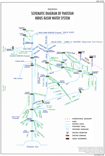
The irrigation system on the Indus River comprises 19 barrages and head works, 12 link canals, 43 commands, and some 107,000 water courses (Figure ). The barrages were constructed decades ago, primarily for irrigation purposes and also for control of flood waters. The barrages in Pakistan feed the world’s largest single unified irrigation network consisting of 9,923 km, with more than 3.05 million ha of command area.
Figure 1. The Indus Basin water system. Source: The World Bank (Citation2010).
The Guddu barrage in the province of Sindh was considered in need of rehabilitation. In the downstream of Guddu barrage, there are two other barrages and they are in Sukkur and Kotri. Generally, construction impacts of barrage rehabilitation may be considered temporary in nature if they are assessed single-handedly, but these impacts may be significant and long term when evaluated in the context of the combined effects of all barrages. A cumulative impact assessment (CIA) is appropriate prior to the construction of massive infrastructures. However, these barrages were constructed more than 60 years before, when environmental laws and regulations were absent, as a result, combined effects of barrages were not studied during pre-construction stage. Recent developments in the country’s environmental laws and regulations (Ahmed & Kazi Citation2005) necessitate a revisit of cumulative assessments during their rehabilitation works. The requirement for conducting an environmental impact assessment for projects is fairly recent in Pakistan (was introduced in 1997 under the Environmental Law), since then more detailed regulations have also been introduced in Pakistan (Fischer Citation2014). Thus a cumulative impact assessment (as part of a broader ESIA study) was initiated by the Sindh Irrigation Department for the proposed rehabilitation works. The objective of the CIA in context of the broader ESIA was to evaluate the cumulative impact due to, (i) rehabilitation of the barrages in the Indus River, (ii) diversion of water, (iii) fragmentation of the Indus River due to barrages, and (iv) other activities and developments that have taken place in up and downstream of the Indus River.
The first and most important step of conducting a CIA (small or large, regional or local) is the proper identification and selection of valued environmental components (VECs), including temporal and spatial boundaries. The process of identifying the most significant VECs for this CIA study is discussed in more detail in Section 3. Approach and Methodology. The VECs related to the barrages in Sindh were identified as, (i) fragmentation of dolphin habitats, (ii) obstruction in fish (hilsa) migration and (iii) irrigation improvements. Then the impact of other recent developments, proposed projects, activities and initiatives were considered and are briefly discussed in the following sections.
1.1. Other project developments and initiatives
In 1991, a Water Apportionment Accord (WAA) was signed by the four provinces of Pakistan (Sindh, Punjab, North-West Frontier Province and Balochistan) to make an equitable distribution of Indus flows. As a result, the Indus River System Authority (IRSA) was created as the regulatory authority for monitoring and distribution of the water sources of the Indus River in accordance with the WAA. In 2005, IRSA appointed a team to review the minimum required environmental flows released downstream of the Kotri barrage. The following aspects were considered to justify the need for water escapages below Kotri Barrage: (i) salinity encroachment in the river, aquifer, and coastal zone, (ii) requirement of coastal stability, (iii) requirement of a sustainable environment, (iv) fisheries, and (v) prevention of salinity accumulation in the Indus Basin.
This review recommended an escapage of 142 cumec (cubic meter per second) at Kotri Barrage throughout the year to check seawater intrusion, accommodate the needs for fisheries and environmental sustainability, and to maintain the river channel (Gonzalez et al. Citation2005). In this review, the riverine forests, riverine agriculture, pollution control and drinking water supply were considered to play a marginal role and hence not considered for environmental flow purposes. The study also recommended a total volume of 25 MAF (million acre-feet) in any 5 year period (an annual equivalent of 5 MAF) be released below Kotri as flood flows (during Kharif period – the season from July to October during the southwest monsoon on the Indian subcontinent) to maintain stable coast line and sustain mangrove vegetation. However, these recommendations were not strictly followed. Water has been generally released in years of floods and extraordinary quantities go down to the sea, whereas in other years, flows are close to zero. Also, since 1990, the Provincial Government of Sindh has implemented a number of initiatives and projects to address some of the above-mentioned issues including:
| (a) | Sindh Water Sector Improvement: This project introduced techniques to reduce irrigation losses, which are now about 35–40%. A large part of the losses are in the watercourse command (over 40%) and the rest are field losses. This project helped to release more flows on the downstream of the barrages due to reduction in wastage of irrigation water and thereby reduced diversion of water to irrigation canals in upstream. | ||||
| (b) | Preparation of a Master Plan for the Left Bank of Indus, Delta and Coastal Zone: A regional master plan for the protection of floods and providing proper drainage to the area on the left bank of the Indus, including the delta and the coastal zone. This occurs through appropriate structural and non-structural measures, such as remedial measures for any outstanding deficiencies in the left bank outfall drain system. Other retention and/or safe disposal of drainage, storm, and flood water; and improvements of wetlands in the delta area and in the coastal zone, recognizing their environmental importance and considerable economic potential for local communities. | ||||
| (c) | On-Farm Water Management Project (OFWMP): The On-Farm Water Management Project has been implemented to better manage irrigation water by the farmers and increase agricultural productivity, supported by improved irrigation infrastructure and service delivery. | ||||
| (d) | Sindh Coastal Area Development: Community organizations have been implementing a Coastal Area Development program. This program addresses the specific problems in isolated coastal areas in the districts of Thatta and Badin, which are prone to regular natural and man-made disasters resulting from seawater intrusion, floods and cyclones destroying the livelihoods and impacting widespread poverty and vulnerability. | ||||
1.2. Baseline state of VECs
Before carrying out a CIA, the first and most important step is identifying important VECs that will be impacted and their baseline state. A baseline assessment of the identified VECs dolphin habitat fragmentation, fish migration, and irrigation was done to evaluate the current state of the most important VECs. The findings, including historical range, are summarized and given below.
1.2.1. Dolphin habitat fragmentation
The Indus River dolphin (Platanista gangetica minor) is amongst the most endangered river dolphin species in the world, second only to the Yangtze River dolphin which is considered functionally extinct (Waqas et al. Citation2012). The distribution of dolphin (Platanista gangetica minor) in Indus River was first documented in the 1870s, (just prior to the construction of the first major barrage) and at that time the dolphin inhabited the entire lower Indus River system from the delta with the Arabian Sea, to the foothills of the Himalayas (Anderson Citation1879). The construction of several irrigation barrages between 1886 and 1971 fragmented the dolphins’ historical range into 17 river sections (numbered 1 to 17 on Figure ). A recent study (Braulik et al. Citation2014) assessed the habitat fragmentation and dolphins’ extirpation (when a species ceases to exist in a certain geographic area, though it still may exist elsewhere) in the Indus River system. The study collected historical dolphin sightings for all river sections formerly occupied by dolphins except at the area downstream of Kotri Barrage to the delta and the stretch from Harike to Hussainiwala barrage, which is close to the India-Pakistan border. Figure shows the rivers and barrages, river sections with a number and color codes according to whether river dolphins are extant, or the approximate date that they were extirpated. By the early 1990s, Indus dolphins had undergone an 80% reduction in range, having been extirpated from the upper and lower reaches of the Indus River and four of the largest tributaries (Reeves et al. Citation1991). They are now confined to five contiguous ‘river sections’ on the Indus River mainstream in Pakistan, separated by barrages (Braulik Citation2006) and in the Beas River in India (Behera et al. Citation2008). The total range of the dolphin is about 1,500 km from Jinnah to Kotri Barrage (Waqas et al. Citation2012). The surveys of entire Indus subspecies of dolphin were carried out in 2001 and 2006 using identical survey methods. The estimated population of dolphins was 924 and 1,406 in 2001 and the 2006 surveys, respectively (Braulik et al. Citation2012). The largest subpopulation, more than 80% of the total in 2001 and 90% of the total in 2006, is concentrated in the Dolphin Game Reserve between the Guddu and Sukkur Barrages, at the downstream end of the subspecies’ range. The next major population is located between Chashma and Taunsa barrages. The most recent counts conducted by Sindh Wildlife Department in 2011 found 918 dolphins between Guddu and Sukkur Barrages and 29 between Sukkur and Kotri barrages (SWDGEMS, Citation2012). Dolphin counts from these three studies are presented in Table .
Figure 2. Lower Indus River system, barrages, time of river dolphins extant and extirpated. Source: Braulik et al. (Citation2014).
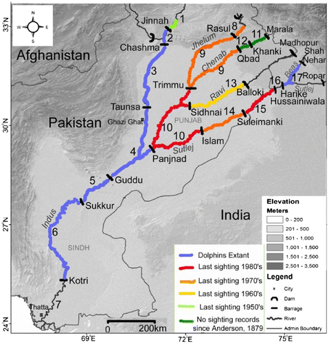
Table 1. Comparison of direct counts of dolphin recorded in 2001 and 2006.
Upstream subpopulations may lose individuals downstream if dolphins move through barrage gates when they are open in the wet season. Individuals are unlikely to move upstream through a barrage because of strong downstream hydraulic forces at the gates. While there have been no direct observations of dolphins moving through a barrage, they often swim through regulator gates into irrigation canals, which, although smaller, present a similar obstacle (Braulik Citation2002). Encounter rates in the farthest downstream subpopulation (between Guddu and Sukkur Barrages) are very high (about 5 dolphins/km), approaching three and half times those recorded in similar surveys elsewhere for Platanista dolphins (Braulik Citation2003).
1.2.2. Hilsa migration
Hilsa (Tanualosa ilisha), locally known as palla, is a migratory fish which ascends into rivers from the sea for breeding and spawning (CitationDay 1879). Hilsa belong to the family of Clupeidae of order Clupeiformes. Majority of the Clupeied fishes are entirely marine and anadromous, and these fishes before their spawning period accumulate high concentration of oils mainly lipid deposits, primarily triacylglycerols, which are subsequently mobilized to support gonad development and spawning migration (Bell Citation1998). Studies conducted in Pakistan on hilsa gonad revealed that at the beginning of spawning season the oil vacuoles coalesce and eventually a large single oil is formed. Some studies observed the fecundity in hilsa ranges from 87,267 to 614,482 in the females ranging from 210 to 350 mm in length (Panhwar et al. Citation2011) and 64,608 to 1,153,383 in females ranging from 201 to 408 mm in length (Narejo et al.Citation1999). No detailed studies were conducted on hilsa in Pakistan to understand its migration patterns. Generally, hilsa migration from sea to Indus River starts from January and continues until July (Bhuiyan & Talbot Citation1968), but it appears that there are two peak migration periods, one in January to February and other between April and July. Before the construction of Sukkur Barrage in 1932, the hilsa was reported to travel a distance of more than 1,000 km up to Multan (Aitkin Citation1907). After construction of Sukkur Barrage, hilsa migration was restricted to Sukkur Barrage (Qureshi Citation1968) since it doesn’t have any fish passes. Kotri and Guddu barrages which were constructed later in 1956 and 1962 have fish passes to facilitate hilsa migration. Fish passes in Kotri Barrage were not properly designed to facilitate migration of hilsa. Hence, after 1956 the migration of hilsa has been restricted up to Kotri Barrage (Jamshoro), 300 km from the sea. This obstruction has deprived hilsa of two-thirds of their previous spawning area (Bhuiyan & Talbot Citation1968).
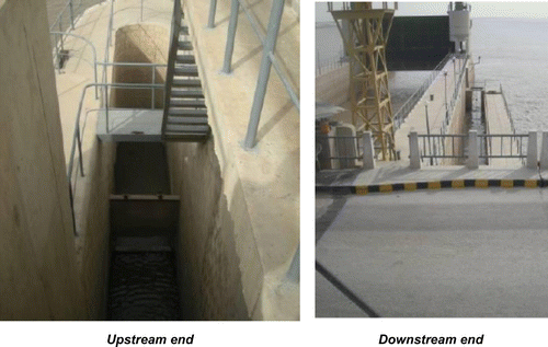
In Guddu barrage there are two fish ladders installed in the outer piers of each abutment pocket i.e. after gate number 7 (Figure ) and after gate number 61 (Figure ) with 85 m length (upstream length is 35 m and downstream length is 50 m), 3 m width, and 1.5 m depth. Left bank ladder is constructed along with the lock chamber wall. Upstream fish ladder is controlled by a screw gate 0.6 m (2 ft) wide. There are cross-partitions in ladders over the entire length that form a series of baffle steps. The right side ladder has two entry gates on the downstream side, one on the left wall and one at the end of the ladder. Both gates are in poor condition. The right side ladder has vertical baffle walls cast into the side of the chute. On the upstream side of the ladder is a single gated opening in the left side wall. This gate was replaced in April 2011 and is in good condition. The left side fish ladder also has two sluice entry gates at the downstream end but the baffles within the chute are horizontal rather than vertical. At the upstream end, there is a single sluice gate on the right side chute wall but also two sluice gates on the left side wall.
Figure 3. Right side fish ladder at Guddu Barrage (Gate 7).
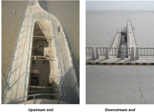
Figure 4. Left side fish ladder at Guddu Barrage (Gate 61).
Turbulence is created at the downstream end of the fish ladders to attract fish so that they can travel upstream. The fall at the downstream end of the ladders is kept above 0.6 m to create this turbulence. The remaining fall is distributed up to the fish pass, ensuring that the fall at any regulation point does not exceed 0.6 m. Fish ladders are designed to work at Barrage minimum winter pond level. The flow of water regulated by adjusting the gate opening and minimum 0.5 m water depth is maintained in the steps so that fish can easily swim rather than jump. There are two fish ladders in Kotri Barrage with same dimensions like in Guddu Barrage located on each of the divide walls. There are no fish ladders in Sukkur Barrage.
1.2.3. Irrigation
Before the construction of Guddu barrage, lands north of Sukkur and Rohri were irrigated by inundation canal system. The low precipitation prevented rain-fed large scale agriculture development in the province. The people adapted to low and poorly distributed rainfall through either living along river banks or by careful husbandry and management of local water resources. The canals depended for their supplies on favorable river levels of Indus during the summer time. The lands in upper Sindh were irrigated by artificial inundation canals: Desert, Unhar, Begari, Sindh Rajib, and Chitti Canals on the right bank and Sehar, Mahi, Dahar, Masu, Mehesro, Lundi, Dingro, Korai, Janib, and Garkino Canals on the left bank. Total cultivated area was 382,428 ha (945,000 acres). The farmers usually used to suffer due to their dependence on the inundation canals.
The three barrages in Sindh over Indus River divert approximately 59 billion m3 of water annually to the 14 main canal commands. These canal systems have an aggregate length of 21,445 km, which serve a gross command area (GCA) of 5.6 million ha. There are about 42,000 watercourses (tertiary channels), which have an aggregate length of about 120,000 km. Around 78% of the area in the Province of Sindh is underlain by saline groundwater, which is unsuitable for irrigation. Surface and sub-surface drainage systems are inadequate, resulting in much of the drainage effluent being either retained in the basin or disposed into the rivers and canals. There are 13 existing surface drainage systems in Sindh, which serve a total area of over 2.5 million ha and have an aggregate length of about 6,133 km. In addition, there are two sub-surface drainage systems, which serve an area of 0.04 million ha.
2. Approach and methodology
2.1. Approach to CIA
Cumulative impacts may cover a broad spectrum of different types of impacts at different temporal and spatial scales. Cumulative impacts may result due to multiple projects of the same type or occur from a combination of effects over a given resource from many different types of projects. Cumulative impacts are caused by successive and/or combined effects of a project when added to other existing or planned projects and activities (Hegmann et al. Citation1999). The CIA can be broadly defined as (i) assessing potential impacts of proposed projects with respect to potential effects of other projects, human activities and natural environmental and social external drivers on VECs and (ii) proposing mitigation/enhancement measures to eliminate, reduce, or mitigate the cumulative impacts (IFC Citation2013). In general, CIAs are conducted prior to the construction of a major infrastructure. However, CIAs can also be initiated prior to the rehabilitation of an infrastructure to see whether design can be modified to an extent that may help in improving or enhancing a VEC from its current poor state. At the core of an effective CIA is assessing how potential impacts of a proposed project may combine cumulatively with potential impacts of other projects (including future proposed projects), human activities and other possible natural environmental and social stressors (Burris & Canter Citation1997).
When carrying out a CIA, it is not possible/or realistic to assess all environmental and social aspects in the CIA. The general practice is to define and evaluate the impact on Valued Environmental and Social Components. VECs are any environmental and social characteristics that are considered to be important for the assessment of risks, they maybe but are not limited to (i) natural processes, (ii) ecosystem services, (iii) physical features such as habitats, and (iii) social and cultural aspects. VECs may be directly or indirectly affected by projects and cumulative impacts from several projects (IFC Citation2013).
The general steps for a typical CIA include: (i) identification of VECs that may be impacted by project, (ii) consultation with stakeholders with regards to identified VECs, (iii) identification of all other existing and planned projects that may impact VECs, including other factors that may affect identified VECs, (iv) assessment of impacts of project and other past and planned projects on identified VECs, including expected impacts from natural environmental and social drivers, (v) assessment of future condition of identified VECs compared to baseline condition, (vi) development of mitigation/enhancement measures to avoid and/or minimize impacts, (vii) monitoring and management of risks to VECs, and (viii) continuous engagement and participation of the affected communities and stakeholders in decision-making process (Hegmann et al. Citation1999).
The impact of human activity or a project on an environmental resource or ecosystem may be considered insignificant when assessed in isolation, but may become significant when evaluated in the context of the combined effect of all the past, present, and reasonably foreseeable future activities that may have or have had an impact on the resources in question. In circumstances where a series of developments of the same type is occurring, or being planned, the need for cumulative impact assessment is fairly obvious. For example:
| • | When a series of barrages were constructed in the same river or within the same watershed with impacts in common on aquatic habitats, flora and fauna, on watershed sediment dynamics, on navigation, on downstream water availability or quality, on loss of estuaries and estuarine habitats, on local communities’ livelihoods, or on adjacent land uses because of increased access from associated roads; or | ||||
| • | When a series of agricultural developments occur that will cumulatively impact land use patterns, having cumulative impacts on downstream water availability (from withdrawal of water for irrigation), on downstream water quality, on habitat fragmentation of aquatic species, or on local community livelihoods. | ||||
2.2. CIA in context of barrage rehabilitation
In the context of the CIA study and selection of VECs, the spatial boundaries of cumulative impact assessment have been based on the jurisdiction of the Government of Sindh. The spatial boundary is the Indus in Sindh and the projects considered for the assessment are the three barrages in Sindh, Guddu, Sukkur, and Kotri. According to development plans, rehabilitation of Sukkur and Guddu barrages were considered as major developments in Indus in next 20 years. Locations of these three barrages are shown in Figure .
Construction of the Guddu Barrage started in 1957 and was completed in 1962. The barrage was constructed primarily for irrigation water to cover 1.32 million ha (3.269 million acres) of command area located in the Jacobabad, Larkana, and Sukkur districts of Sindh and the Nasirabad district of Balochistan. The barrage is feeding the Ghotki Feeder and Rainee canals on the left side and Beghari Sindh Feeder and Desert Pat Feeder canals on the right side. The structure is also supporting a road link across the Indus River and provides cooling water for the Guddu thermal power plant. Two major gas pipelines from Sui Fields cross the barrage to link with the Multan-Sukkur main gas pipeline. The barrage is 1,355 m long and the design discharge is 33,980 cumec. The barrage has 64 spans with a length of 18.3 m each and a navigation lock with a span of 15.24 m.
The Sukkur Barrage was commissioned in 1932 and it is the world’s largest single unified irrigation network of 9,923 km, feeding an irrigation system, with more than 3.05 million ha of command area. Sukkur Barrage was the first barrage constructed on Indus River with a design discharge of 42,475 cumec. The total length of the barrage is 2.91 km, it has 66 spans with 18 m length each, and each span has a gate weighing 50 t. The feasibility study for the planned rehabilitation of Sukkur Barrage is currently underway. The stretch of Indus between Guddu and Sukkur Barrages forms the Dolphin Reserve. The barrage has no fish passes. There is a need for rehabilitation of the Sukkur Barrage mainly due to expiry of useful life of barrage gates and canal head regulators.
The Kotri Barrage was commissioned in 1955. Kotri Barrage is used to control water flow in the River Indus for irrigation and flood control purposes. The barrage has a design discharge of 21,238 cumec. It is a gate-controlled weir type barrage with a navigation lock. The barrage has 44 spans, each 18 m length with a total length of 1,600 m. The maximum flood level height of Kotri Barrage is 13.14 m. It feeds Fulleli, Pinyari, Akram Wah, and Kalri Baghar Feeder Canals and serve a command area of 1.14 million ha. The barrage has two fish passes. Kotri Barrage was rehabilitated recently.
2.3. Identification of VECs for the CIA
A matrix was prepared (presented in Table ) to depict the impacts of barrages on the Indus River, including components of ecosystems and socioeconomic environment. The impact may be considered localized depicted by ‘L’ or cumulative depicted by ‘C’, where in this context, ‘localized’ means an impact is confined to the area of influence of the barrage and is not transmitted beyond this area, and ‘cumulative’ impact is the aggregate impact of a number of barrages on any component. The impact is in increasing order of impact from negligible, low, medium, and high. The following components are covered under this CIA: (i) sedimentation, (ii) dolphin habitat fragmentation, (iii) fish migration pattern, (iv) environmental flow and associated impacts, (v) change in irrigation, (vi) loss of agricultural land, (vii) coastal stability, and (viii) water logging and salinity.
Table 2. Cumulative impact analysis of barrages on components of the ecosystem.
Based on consultations and analysis in Table , three VECs were identified for the CIA study. These VECs and their significance are given below:
| • | Dolphin habitat fragmentation: Before construction of barrages on Indus, dolphins were reported to inhabit entire Indus basin. Construction of barrages and diversion of water for irrigation has resulted in fragmentation of dolphins’ habitat and finally extirpation of dolphins in many river sections of Indus and its tributaries. Currently dolphin population is limited to the lower Indus in Sindh with River reach between Guddu and Sukkur being a protected area for dolphins. | ||||
| • | Obstruction of fish migration: Before construction of barrages in Sindh, hilsa were reported to migrate from the sea to the Indus River, to a distance of more than 1,000 km up to Multan in Punjab. After construction of barrages in the Indus, the hilsa migration is restricted to Kotri Barrage, 300 km from the sea. This has drastically reduced the commercially important hilsa fish catch and its spawning area. | ||||
| • | Irrigation: Before construction of barrages, some parts of Sindh were irrigated by traditional inundation canal system, which generally provide uncertain and precarious supplies during crucial sowing and maturity periods. Due to low precipitation and saline groundwater, canal inundation is the only source of water for irrigation in Sindh. Construction of barrages have transformed the arid barren lands of Sindh into vast agricultural lands and brought significant socioeconomic benefits to Sindh. | ||||
Mitigation measures for the identified VECs are recommended under this study or managed through existing programs or addressed by engaging consultations with various national stakeholders.
3. Results and discussion
3.1. Habitat fragmentation by barrages
The occurrences of Indus dolphin consistently decreased in the upstream ranges from approximately 3,400 km of the main channel and its tributaries in the 1870s (Anderson Citation1879) to approximately 1,000 km of the main channel today. An estimated 99% of the Indus dolphin population occurs in only 690 linear km, corresponding to an 80% reduction in the area of occupancy. The study conducted by Braulik et al. Citation2014 concluded that there is a strong relationship between low dry-season river discharge and the decline of the Indus dolphin. Where dolphins are still extant, the median monthly dry season river discharge averaged 873 cumec (ranged 205–1,332 cumec), as compared to an average of 227 cumec (range 0–1,076 cumec) in locations from which dolphins have been extirpated (Braulik et al. Citation2014). In general, river stretches where dolphins are still present were fragmented by barrages later, are farther from the range periphery, are of the longer length, have a shallower slope, and greater dry season discharge compared to those river stretches where dolphins are no longer present. Reduced discharge of the Indus River directly affects dolphins by reducing the living space available to them, reducing average water velocity and depth, and increasing water temperatures.
The consequence of fragmentation of dolphin habitats is very severe: out of 17 stretches of Indus River system except 6, dolphins have been extirpated. The persistence of dolphins in the Beas River, India (Figure ) is likely to be due to the presence of constant water supplies little depleted by diversions. Dolphins in the Beas River occur in an isolated fragmented habitat as the river downstream is virtually dry, and only connected with the rest of the river system for a few weeks each year during the monsoon floods. The persistence of Beas River dolphin demonstrates that in the presence of sufficient water, and in the absence of other threats, river dolphins can persist for decades even in relatively small fragments of habitat near the periphery of their range. Based on the historical pattern of decline, Indus dolphins are most likely to disappear in the future from locations with low river discharge located closer to the range periphery, meaning that dolphins in the Beas (close to range periphery with moderate discharge) and between Sukkur and Kotri Barrages (with low discharge, located in a moderate distance from the former range edge) are most at risk. In addition, the altered hydrological regime on the Indus River has likely reduced the complexity of hydrologic and geomorphologic habitat and ultimately also diminished its carrying capacity and ability to support large numbers of dolphins.
The principal characteristics for declining or threatening a species are the contraction of geographic range. Populations occupy less favorable habitat and occur at lower and more variable densities at the periphery of a species geographic range. Therefore, when a species becomes endangered, it is expected that its geographic range will contract inwards, and the population will persist in the range core until the final stages of decline (Lomolino & Channell Citation1995). However, for many endangered mammals the pattern of range decline is instead dictated by a number of factors influencing the decline, with those populations last impacted, regardless of their location, persisting longer than those that were historically large (Braulik Citation2003). The range of the Indus dolphin has also been contracted inwards, and dolphins persist primarily in what is assumed to be the former range core or higher density area. The contraction of the range or habitat is due to the greatest threat or water diversion through canals which is primarily in the periphery or the outer range of the dolphin habitat.
3.2. Impacts of barrages on fish migration
During the early stage of migration (January–February) of hilsa, there is hardly any water available in downstream Kotri (Figure ) for hilsa to migrate to upstream. The fisherman catch the fish in the deltaic region only. However, later migration during summer monsoon floods (April–July), means that the palla fishing is carried out from Jamshoro to Keti Bunder, on the downstream of Kotri Barrage.
Figure 5. Monthly discharge at downstream Kotri and hilsa migration.
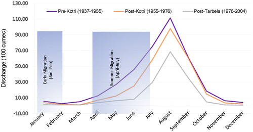
Annual hilsa catch of last six decades indicate that in the 1950s annual catch was close to 13,000 t, which decreased to 2,700 t in 1962 and then again started to increase with peak annual catch of 11,800 t in 1973 (Table ). Over the last four decades, hilsa annual catch has been reduced from 9,098 t in 1974 to 269 t in 2013 (FAO Citation2015). The changes in annual hilsa capture trend may have different factors, but the most logical one could be the construction of Kotri Barrage in 1955 and subsequent obstruction of migration patterns. The catch declined up to 1961 (7,800 tons) but not significantly and a major capture of 11,800 t in 1973 may be explained due to the super flood of 19 August 1973, during which hilsa were able to travel through the flood plains in upstream locations and were caught by the fisherman. With the advent of fishing nets and motorized fishing boats, since the 1970s the captures tend to increase including the juvenile group (undersized catch), which was the beginning of the major decline of hilsa in the estuaries and little space for them to survive in large scale. The major factor severely threatening the fishery is the low flow of freshwater to the sea beginning from the upstream barrages including Guddu (Figure ) Sukkur (Figure ) and Kotri (Figure ), and hilsa appears to be the most vulnerable due to its fluvial migration toward the Indus River (Jafri Citation1988). Hilsa fishery has been providing a livelihood to a large number of fisherman in Sindh, some of whom migrate to Jamshoro area from Sukkur and Larkana districts during hilsa migration periods.
Table 3. Annual catch of Hilsa in Pakistan.
Figure 6. Guddu Barrage. Source: Google Earth, NASA, DigitalGlobe.
Figure 7. Sukkur Barrage. Source: Google Earth, NASA, DigitalGlobe.
Figure 8. Kotri Barrage. Source: Google Earth, NASA, DigitalGlobe.
3.3. Irrigation
The construction of three barrages in Sindh has been diverting about 3,920 cumec to the canals and resulting in irrigation of 5,572,995 ha of land (Table ). The benefits of the construction of a series of barrages on the Indus River system has a cumulative positive impact on the socio-economy by increased irrigation, which brought the green revolution in this region of the world.
Table 4. Irrigation supplies and command area of barrages.
Crop productions in Sindh have been gradually increasing since last 60 years after the construction of barrages. Major food crops such as wheat, rice, maize, pearl millet, sorghum, and barley production in Sindh in 1981–1982 were 3.83 million t and increased to 6.16 million t (about 61% increase) in 2008–2009; on the other hand, cash crops such as, cotton, tobacco, sugarcane etc. production in 1981–1982 was 7.78 million t and increased to 13.84 million t (about 78% increase) in 2008–2009.
Agriculture is the main stay of Pakistan’s economy. The agricultural sector, with a share of about 22%, was the single largest contributor to the GDP. About 68% of the rural population depends on agriculture, which employs over 46% of the labor force and accounts for more than 60% of foreign exchange earnings (Azad et al. Citation2003). Pakistan’s economic development is therefore directly linked to the progress of the agriculture sector. Sindh’s contribution to Pakistan’s agriculture GDP is 23% with its contribution of major products as follows:
| • | Wheat, 15% | ||||
| • | Cotton, 23% | ||||
| • | Livestock, 28% | ||||
| • | Sugarcane, 31% | ||||
| • | Rice, 42% | ||||
| • | Marine fish, 70% | ||||
A large amount of irrigation water is currently being wasted by farmers due to inefficient use of irrigation water. There is a tendency of farmers to irrigate crops with more water with the belief that more water results in higher productivity. Further there is also a tendency to grow rice in well-permeable soils. It has been estimated that about 35 to 40% of irrigation water is being lost through these practices and also from transmission losses. Excess irrigation coupled with the poor drainage system in Sindh has resulted in water logging in shallow groundwater level areas and increased soil salinity. The average severely waterlogged area with water table depth of 0–1.5 m in April–June is about 2.16 million ha in Sindh (Lashari & Mahesar Citation2012). Salinity and sodicity are associated with irrigation but these also occur as a consequence of soil formation process over the centuries. Waterlogging, salinity, and sodicity have reduced the drainage capacity of the soils resulting in lower soil fertility, decline in crop yields and loss of crop diversity (Shah et al. Citation2011). Almost 50% of the culturable command area in Sindh does not have drainage facilities. The present surface drainage density is usually not more than 3–7 m/ha which leaves much of the land without a drainage system (Azad et al. Citation2003), therefore water logging permanently exists.
4. Conclusions and recommendations
As was discussed in the previous section, it was found that there is a strong correlation between altering the hydrological flow regime of a river (reduced river discharge) and extirpation of dolphins in certain sections of the rivers. Altered flow regime (reduced flow) also was found to have a negative effect on the hilsa. The obstruction of migration patterns was highlighted as another major factor affecting hilsa and their spawning. For the third VEC (irrigation), it was concluded that although there has been a tremendous benefit to irrigation and agriculture, up to 40% of the diverted water is lost due to inefficient irrigation practices. To address the above impacts and concerns, mitigation/enhancement measures were developed based on field visits, stakeholder consultations, review of field and project reports.
The following recommendations are made to protect dolphins: (i) Provide measures to prevent entry of dolphins into canals through installation of screens in the canal gates or installation of dolphin deterrent devices such as pingers; and (ii) A Dolphin Management and Conservation Action Plan is recommended to be carried out to strengthen the conservation measures in dolphin game reserve. The plan is developed based on field visits, stakeholder consultations and will include the following:
| • | Initiate population status survey: There is no comprehensive data base available on Indus dolphins. Detailed surveys are required to develop an understanding and knowledge on the species and to develop a detailed management plan for conservation of dolphins. | ||||
| • | Setting up of no fishing zones in the Game Reserve: Occurrences and identification of river stretches that support breeding and feeding grounds of dolphin, critical dolphin habitats will be identified that require protection from fishing. | ||||
| • | Community involvement in river dolphin conservation and management: The involvement or active participation of local stakeholders like traditional fishing community and other riverbank communities is essential for dolphin conservation. | ||||
| • | Ensuring critical levels of water flow in riverine habitats of dolphins: The survival of the Indus River dolphin and a host of other aquatic wildlife are dependent on riverine ecology in general and the maintenance of an optimum water flow. Based on systematic and continued research and regular monitoring with the involvement of hydrologists and other multi-disciplinary professionals, critical water flow and minimum depths for river dolphin habitats should be determined, and management actions should be set in place to maintain such flow and depth. | ||||
| • | Education and awareness: Education and awareness program to be conducted to increase the awareness level of all spectrums of the society about dolphin, its habitat requirements, and its current threatened status. For example, declaring the dolphin a National Aquatic Animal will create lot of public awareness. | ||||
Design improvements in fish ladders and installation of new effective fish ladders in the absence of one in barrages can significantly improve fish migration by diminishing physical barriers. Prior to the design of ladders, scientific study is required to understand the biological requirements of hilsa, its swimming capabilities, and water velocities and depth required to attract hilsa to use fish ladders, breeding habitats, and migration route.
The main purpose of the barrage rehabilitation is to continue the sustained supply of water through the canals for irrigation. However, it is utmost important that the precious water is also used effectively by the farmers without wasting it. Reduced wastage of irrigation water will allow more water to be discharged in to the downstream of the barrages, which eventually help maintaining the environmental flow in the downstream and reduce negative impacts on dolphin and hilsa.
Disclosure statement
No potential conflict of interest was reported by the authors.
Funding
This work was supported by the Government of Sindh and Engconsult Ltd., Canada.
Acknowledgment
The authors wish to confer thanks to the Sindh Irrigation Department, Pakistan, and the World Bank-Islamabad office for providing support during the whole study period.
References
- Ahmed I, Kazi M. 2005. Environmental law in Pakistan – governing natural resources and the processes and institutions that affect them: part 1 federal. Gland: IUCN.
- Aitkin EH. 1907. Gazetteer of the province of Sind. Karachi, Pakistan: Sindh Provincial Government; p. 73–74.
- Anderson J. 1879. Anatomical and zoological researches: comprising an account of zoological results of the two expeditions to Western Yunnan in 1868 and 1875; and a monograph of the two cetacean genera, Platanista and Orcella. London: Bernard Quaritch.
- Azad A, Aslam M, Memon Y. 2003. Sindh water resources management – issues and options, Occasional Paper Series no. 15. Rome: Food and Agriculture Organization of the United Nations – Investment Center Division, FAO/ World Bank Cooperative Programme.
- Behera SK, Nawab A, Rajkumar B. 2008. Preliminary investigations confirming the occurrence of Indus River dolphin Platanista gangetica minor in River Beas, Punjab, India. J Bombay Nat Hist Soc. 105:90–126.
- Bell JC. 1998. Current aspects of lipid nutrition in fish farming. In: Black, KD and Pickering AD, editors. Biology of farmed fish. Sheffield: Sheffield Academic Press Ltd.; p. 114–145.
- Bhuiyan NI, Talbot GBI. 1968. Fluvial migration spawning fecundity of Indus river Hilsa ilisha. Trans Am Fish Soc. 97:350–355.
- Braulik GT. 2006. Status assessment of the Indus River dolphin, Platanista gangetica minor. March−April 2001. Biol Conserv. 129:579–590.
- Braulik GT, Arshad M, Noureen U, Northridge SP. 2014. Habitat fragmentation and species extirpation in freshwater ecosystems; causes of range decline of the Indus River Dolphin (Platanista gangetica minor). PLoS One. 9:e101657. doi:10.1371/journal.pone.0101657.
- Braulik GT, Bhatti ZI, Ehsan T, Hussain B. 2012. Robust abundance estimate for endangered river dolphin subspecies in South Asia. Endanger Species Res. 17:201–215.10.3354/esr00425
- Braulik, G.T. 2002. Entrapment of Indus dolphins (Platanista minor) in irrigation canals: incidence, implications and solutions. Cambridge: International Whaling Commission, Scientific Committee Document SC/52/SM9.
- Braulik GT. 2003. Indus dolphin conservation project. Comprehensive survey and status report. March–April, 2001. Report for the World Wide Fund for Nature – Pakistan; Lahore, Pakistan.
- Burris RK, Canter LW. 1997. Facilitating cumulative impact assessment in the EIA process. Int J Environ Stud. 53:11–29.
- Day F. 1878. The fishes of India: a natural history of the fishes known to inhabit the seas and fresh waters of India, Burma and Ceylon. London: Williams and Norgate Publishers.
- FAO Fishstat J Software, Capture Production 1950–2013 Dataset. Release date: March 2015.
- Fischer TB, editor. 2014. EIA handbook for Pakistan. Pakistan: IUCN.
- Gonzalez FJ, Basson T, Schultz B. 2005. Review of studies on water escapages below Kotri Barrage. Final Report of International Panel of Experts, Delft, The Netherlands.
- Hegmann G, Cocklin C, Creasey R, Dupuis S, Kennedy A, Kingsley L, Ross W, Spaling H, Stalker D. 1999. Cumulative effects assessment practitioners guide. Hull, Quebec: AXYS Environmental Consulting Ltd. and the CEA Working Group for the Canadian Environmental Assessment Agency.
- IFC. 2013. Good practice handbook: cumulative impact assessment and management: guidance for the private sector in emerging markets. Washington, DC: International Finance Corporation, World Bank Group.
- Jafri SIH. 1988. Biology and fishery of River Indus shad (Palla). A review. Pak J Agric Res. 9:252–263.
- Lashari B, Mahesar MA. 2012. Potentials for improving water and agriculture productivity in Sindh, Pakistan. Sixteenth International Water Technology Conference, IWTC 16 2012; Istanbul, Turkey.
- Lomolino MV, Channell R. 1995. Splendid isolation: patterns of geographic range collapse in endangered mammals. J Mammal. 76:335–347.10.2307/1382345
- Narejo NT, Ali SS, Jafri SIH, Hussain SM. 1999. A study on the age and growth of Palla, T. ilisha, from the River Indus. Pak J Zool. 31:25–29.
- Panhwar SK, Siddiqui G, Ayub Z. 2011. Reproductive pattern and some biological features of anadromous fish T. ilisha from Pakistan. Indian J Mar Sci. 40:687–696.
- Qureshi MR. 1968. Problems concerning fishery of hilsa, Hilsha ilisha (Ham.). Pakistan J Sci Ind Res. 11:85–94.
- Reeves RR, Chaudhry AA, Khalid U. 1991. Competing for water on the Indus Plain: is there a future for Pakistan’s river dolphins? Environ Conserv. 18:341–349.10.1017/S0376892900022591
- Shah AH, Gill KH, Syed NI. 2011. Sustainable salinity management for combating desertification in Pakistan. Int J Water Resour Arid Environ. 1:312–317.
- Sindh Wildlife Department and Global Environmental Management Services. 2012. Baseline study of Indus dolphin Guddu to Sukkur Barrage and Sukkur to Kotri Barrage. Sindh, Pakistan.
- The World Bank. 2010. Project Appraisal document of Punjab Barrages Improvement Phase-II Project. Report no. 51016-PK. Sustainable Development Department, Agriculture and Rural Development Sector Unit, South Asia Region.
- Waqas U, Malik IM, Khokhar LA. 2012. Conservation of Indus River dolphin (Platanista gangetica minor) in the Indus River System, Pakistan: an overview. Sukkar: WWF-Pakistan, Indus River Dolphin Conservation Centre Lab-e-Mehran.