
Abstract
Territorial Impact Assessment (TIA) is proposed as a critical tool in order to investigate the way policies affect spatial development and hence territorial cohesion. The paper introduces a TIA methodological model in relation to transport sector. The design of the methodological model is based on a quantitative evaluation framework that comprises a set of selected indicators applied in a cross-border area of southeast Europe, influenced by the operation of the Greek motorway system of Egnatia and its vertical axes. The indicators are grouped into three main fields of TIA, i.e. transport intermodality, polycentric spatial organization and cross-border territorial cooperation. The TIA’s indicators are approximated by quantitative analysis. The procedure concludes to an overall composite indicator measuring the ‘level of territorial cohesion’ along with some core results and the expected added value. It also highlights some key technical aspects about the routines used and proceeds to suggestions for further refinement.
1. Introduction
Territorial impacts are considered the impacts on a given geographically defined territory resulting from the introduction or transposition of EU policy. In this context, Territorial Impact Assessment (TIA) provides the mechanism for the consideration of the territorial dimension of EU policies by contributing to the identification of their impacts at national, regional and local level and their differentiation between different places (ESPON Citation2013a). The European Commission steadily supports this territorial dimension for the impact assessment of all policy domains (CEC Citation2002, Citation2004; EC Citation2005, Citation2009, Citation2015) and provides clear guidelines for its integration to impact assessment studies (EC Citation2013a). TIA methodology is often used under the European Spatial Planning Observation Network (ESPON) Programme to support the purposes of its policy analysis, including the transport policy domain (ESPON Citation2005, Citation2010, Citation2013b).
Based on the above background and available practice, TIA is approached in the present paper through the creation of a quantitative and integrated tool, able to synthesize the aspects of intermodality, polycentricity and cross-border cooperation for the measurement of the potential impact on cohesion due to the completion and full operation of the Egnatia motorway and its vertical axes. This model is part of a study focusing on the broader cross-border area of northern Greece and incorporating quantitative and qualitative assessment approaches based on a system of 28 indicators (Egnatia Odos Observatory Citation2015).
The Egnatia motorway is one of the largest road projects constructed in the last years in Europe, included in the priority projects of Trans-European Transport Networks. This infrastructure creates a new mobility environment for people, goods and services within Greece and in is cross-border area (Fourkas et al. Citation2010). The construction of this road system was funded by national, EU and EIB (European Investment Bank) sources with a cost of € 6.7 bn. The 670 km main axis from Igoumenitsa port (gateway to Italy) to Kipoi (border crossing to Turkey), crosses five regions of Northern Greece. It connects 9 airports, 5 ports, 50 industrial and business zones and many tourist and cultural sites. This area of immediate influence represents half of the national territory and approximately a third of the national population, employment and GDP. Moreover, it links Greece to Europe and the Middle East, while its vertical axes collect traffic from other TEN-Ts crossing SE Europe. According to an ex-post evaluation report for the EC-DG REGIO, the motorway succeeded in achieving the expected objectives and contributed to the economic development of the context in which it took place. However, effects on territorial cohesion are expected to be wider in the future. Being a TEN-T network connected through vertical axes to the neighbouring countries, it creates the conditions for improving territorial cohesion at the European level (CSIL Citation2012).
The paper first discusses the meaning and importance of TIA along with the introduction of its objective. A brief description of the study area follows, highlighting the existing and potential role of the Egnatia motorway system in the wider region. The next part introduces the methodological model and its application aspects. The analysis also discusses several concerns on key conceptual and methodological points. Conclusions refer to the interpretation of the resulting figures regarding the cohesion potential and its components (polycentricity, intermodality and cooperation) in this cross border study area. Added value is also included pointing aspects for further utilization.
2. Territorial Impact Assessments of transport
Territorial Impact Assessment (TIA) is highlighted by the European Commission as a prerequisite to ensure the integration of spatial development strategies into large transport projects since 1999 (CEC Citation1999). In the past two decades significant research effort is conducted in Europe for the investigation of innovative TIA methodologies (Camagni Citation2009; Fischer et al. Citation2015) and the adjustment of such methodologies to the needs and specific characteristics of a project or region (Golobič et al. Citation2015). The methodology presented in the current paper is part of an impact evaluation procedure developed for the Egnatia motorway Observatory with focus on the broader cross-border spatial impact of Egnatia motorway, a motorway axis in northern Greece which is part of the trans-European Transport Network.
In 2008, the European Commission adopted the ‘Green Paper on territorial cohesion’ (CEC Citation2008). According to the Green Paper, territorial cohesion aims at ensuring the harmonious development of all regions, the enhancement of relations and the increase of the flow of goods and population between them, the lifting of their isolation and the improvement of their accessibility (Peters Citation2003; Lopez et al. Citation2008).
Transport policy can play a significant role in territorial cohesion by promoting a balanced and sustainable development in the EU and by improving the accessibility conditions of isolated or disadvantaged regions (EC Citation2011a). The European transport policy is primarily concerned with the implementation of the trans-European Transport Networks (TENs-T) and plays a vital role in planning-realization of transport projects in and between country-members, in cross-border mobility and, further, in trans-border territorial interaction and cohesion (EC Citation2013b).
The TEN-T network is expected to create new perspectives for spatial development, enhance opportunities for urban centres and contribute to the minimisation of environmental impacts of the transport system. At the same time, the European Commission acknowledges the need of synergies in regional development and transport planning to promote accessibility, cooperation and cross-border flows in Europe (EC Citation2011b). Nonetheless, several concerns have been recorded about the environmental implications of such large-scale infrastructure. Synergies with other policies of territorial organization could promote their sustainable performance (Fischer and Sykes Citation2009).
In northern Greece for instance, the significant improvement of road transport infrastructure, with the completion of the EU co-funded Egnatia motorway along with its vertical road axes, has not only raised the previous remoteness and low accessibility of this zone; it has drastically affected trans-border connectivity posing significant effects on spatial interactions between trans-border regions in southeast Europe (Fourkas et al. Citation2010; Fourkas Citation2015).
In this context, the evaluation of the quality of transport infrastructure investments should regard also the expected territorial impacts. Therefore, transport strategy should refer to and monitor the Territorial Impact Assessment. TIA becomes then a policy assessment tool able to support territorial cohesion in Europe and its regions (Fischer et al. Citation2013).
Having that in mind, the present paper aims to present a methodology for the TIA of transport infrastructure in a trans-border impact zone that is based on a comprehensive theoretical approach initially developed by Bruinsma et al. (Citation1997), which reveals that such a TIA can be founded on three pillars: (a) Polycentricity that refers to the characteristics, structure and relationships of the network of settlements, (b) Transport intermodality that allows the combination of existing multimodal transport infrastructure and services, boosting the principles of sustainable mobility and (c) Territorial cooperation that can be reached through the diagnosis of cross-border flows.
The understanding of the relationship of the above parameters constitutes the core of the present paper. The central working hypothesis is that the promotion of intermodality of transport infrastructure enhances both the polycentric territorial organization and the opportunities for cross-border territorial cooperation and, thus, it may enhance the cohesion potential of the study area.
3. Study area
The definition of the study area is the result of an extensive analysis of the wider southeast Europe that took into consideration: (a) the analysis of flows, (b) the development characteristics – potentials, (c) the key findings of the territorial/development plans emphasizing transport, (d) the aspects of territorial cooperation, (e) the transport endowment and its operation and (f) the role and prospect of the Egnatia motorway system in servicing this area.
The understanding of transport multimodality proved to be crucial in finalizing the study area. Despite the fact that the multimodal transport system of the wider area is currently under development (nodes, terminals, connectors), the entire transport network was used as a grid to reveal strong or weak relations and to understand the trends. Within this context, the system of Egnatia motorway and its vertical axes functions or has the potential to function as a complementary or competitive corridor to other TEN-Ts in its northern perimeter, especially those operating flows in east-west direction. At the same time it services traffic coming from or entering the vertical TEN-Ts (north-south direction). In both cases, the Egnatia motorway sets the conditions for improved communication between regions with significantly constrained ways of communication in the past. Thus, the system of Egnatia motorway and its vertical axes can be seen as a unification factor, exactly like the Danube determines a territorial system in its basin; a sort of a macro-region, with high potential for development triggered by the arising interrelations of the urban network along (Racz Citation2014).
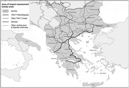
Considering the above, the analysis for the determination of the study area concluded to a broad area that includes Greece, Albania, Fyrom, Bulgaria, the European part of Turkey, Puglia region in Italy and the Serbian territory up to Belgrade. The study area of the impact assessment along with its NUTSII (Nomenclature of Territorial Units for Statistics, level II) administrative division and the TEN-Ts (road and the Danube), is depicted in Figure .
Figure 1. Study area of impact assessment. Source: Author.
4. Methodological model
The adopted methodological model took into consideration the national and international – European experience in developing systems of indicators for monitoring territorial impact. The model is deployed in three general steps (see Figure ).
Figure 2. Methodological model flowchart.
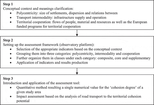
The first step sets the conceptual and methodological references for clarifying the meaning of polycentricity, intermodality and territorial cooperation in the given cross-border area. It is accepted that polycentricity can be assessed and quantified by specific characteristics of the network of settlements such as size, dispersion and relations between. Transport intermodality can be assessed and quantified by the performance of the transport system in terms of infrastructure supply and operation. Finally territorial cooperation can be assessed and quantified by taking into consideration the cross-border flows of people, material and resources as well as the European funded programmes of territorial cooperation.
The second step deals with the selection of the appropriate indicators taking into account the conceptual framework set above. These indicators should comply with the international experience and be relative to the platform already operated within the Egnatia’s Observatory System (to ensure applicability). Moreover, the indicators should be appropriate for examining and illustrating the aspects of the study in a balanced way without ignoring important impacts (Laedre et al. Citation2015). What is actually done in this step is the formation of a specific observatory platform dedicated to the scope of this project. Thus, each of the three components: polycentricity, intermodality and cross-border cooperation, is seen as a discrete Category of indicators. Then, every Category is equipped with indicators suitable to cover certain needs of the undergoing analysis: there is one composite indicator, a group of core indicators and a group of supplementary indicators. The composite indicator uses the results of the core indicators as input to produce a numerical value corresponding to the degree of polycentricity/intermodality/cooperation of the given study area. The core indicators are critical inputs for the quantification of the composite indicator, while the supplementary indicators are used for the qualitative understanding of certain impacts.
The third step aims to the construction of a synthetic tool for the assessment and understanding of the impacts of the road transport system (in this case TEN-T Egnatia motorway) in the given study area. The tool introduces a quantitative method in order to assess the level of cohesion in this area by using the composite indicators of the three indicator Categories. More specifically, the quantitative method concludes in a numerical value for the typological representation of the territorial ‘cohesion degree’ of the given study area, based on the assumption that the road network (in this case TEN-T Egnatia motorway) acts as a catalyst for reconfiguring the aforementioned pillars of cohesion: impacts regarding the polycentricity of space, the intermodal operation of transport and the enlargement of cross-border cooperation.
5. Application of the model
Following the selection of the appropriate indicators and the development of a framework to assess the case-specific characteristics, the application procedure starts with the calculation of the entire indicators system: 3 Indicator Categories (Polycentricity-POL, Intermodality-INT, Cross-Border Cooperation CBC) further organized in 3 classes (composite, core and supplementary).
The application of each indicator is based on a specific methodology that is recorded in a dedicated technical sheet. This technical sheet covers issues such as name, coding, description, scope, spatial and temporal justification, specifications – calculation routine, data sources, type and form of results, possible drawbacks etc.
Besides the specifications – calculation routine itself, a critical aspect in order to secure validity of the calculation outcome is the retrieval of reliable initial data covering a sufficient time span in the territorial/administrative breakdown of the area under study. More specifically:
| • | Specifications – calculation routines derived and adjusted where necessary from relevant indicators already in application under major observatories (i.e. Eurostat, Organization for Economic Cooperation and Development (OECD), European Environmental Agency (EEA), Egnatia Odos S.A. Observatory) or proposed through research (i.e. ESPON, EU funded territorial cooperation programs). | ||||
| • | Focusing on the above-mentioned composite indicators, data were derived: (a) from Eurostat and the national statistical agencies of Greece, Albania, Bulgaria, Fyrom, Italy, Serbia and Turkey [population, settlements population, Gross Domestic Product (GDP), transport terminals – including the intermodal ones, passenger and freight volumes served by ports and inland ports, trade volumes, tourist flows, migratory flows – censuses], (b) Airport operators (Athens International Airport, Tirana International Airport, Civil Aviation Agency of the Rep. of Macedonia, Belgrade International Airport, Istanbul Ataturk International Airport) for passenger and freight volumes served by airport terminals, (c) National strategic documents regarding transport and territorial organization for all the study area countries (transport terminals – including the intermodal ones), (d) Association of Greek Tourism Enterprises (SETE), (e) OECD and Central Banks of all study area countries (foreign direct investments, trade volumes). Where necessary, primary information was produced through GIS modelling and application. In this case, geospatial data were acquired by the Egnatia Odos SA Observatory – GIS department. | ||||
| • | Regarding data timeline, a yearly availability is definitely the most convenient time span. However, taking into account current data availability, a 5 years lap or a decade in some cases proved to be sufficient enough in order to come up with a valid result. | ||||
| • | Administrative breakdown for territorial reference purposes goes from national to subregional following the NUTS classification (NUTS0, II and III). The NUTS system helps to comply with the international standards in data systematization and thus, further analyse and communicate the results effectively. In some cases local entities such as cities [Functional Urban Areas (FUAs) or settlements] and transport nodes were inserted according to the indicator specifications. | ||||
A short description of the system of indicators, classified in Categories and classes per each category, is presented in Table . Each composite indicator uses the results of the Category’s core indicators as inputs to produce a numerical value, which constitutes the polycentricity degree, the intermodality degree and the degree of territorial cooperation, respectively.
Table 1. System of indicators.
6. Composite indicators: elaboration aspects and calculation processes
The introduction of a composite indicator per each thematic category (polycentricity, transport intermodality and cross-border cooperation) reflects the need to better communicate the results of the territorial impact analysis in the study area. It leads to the creation of a single value capable of expressing the ‘degree’ of the phenomena under study. As such, it can be treated independently leading to partial (disciplinary) understandings. On the other hand, these stand-alone values can be synthesized in order to produce ways to ‘measure’ the cohesion potential of the study area.
6.1. Composite indicator POL00 polycentricity degree
The degree of polycentricity is expressed as the aggregation of the values produced by the analysis of the network of settlements in terms of size – ranking (S), dispersion or location (D) and connection or relations between (C) (see formula Equation1(1) ) (Nordregio Citation2005; Gløersen Citation2008; ESPON Citation2012; Brezzi and Veneri Citation2014). These parameters are taken of equal weight. The value produced is dimensionless and already stretched in a 0–100 scale. However, the greater the value the more polarized the area of study in terms of its polycentricity degree. In order to create a proportional representation, the value should be subtracted from 100 (the greater the value the more polycentric the area).
(1)
6.1.1. Calculation of the S (size – ranking value)
The S value is composed of two sub-values, which contribute equally to the final outcome: (a) size – ranking according to the population (NUTSIII capital cities) and (b) size – ranking according to the GDP/capita (assessed for the NUTSIII capital cities). The calculation formula (see formula Equation2(2) ) applied in each sub-value is described below and is based on the relationship of the magnitude of each settlement being equal to the size of the first ranking one by its position in the ranking order.
(2)
where: P the size of a settlement (population or GDP/capita), x the ranking order of the settlement (based on the population or GDP/capita), β 0 the value of the first city at the intersection of the regression line with the Y axis (primacy rate) and β 1 the slope of the curve. For each sub-value, the linear regression of the natural logarithm of the ranking list and the size of the settlements allows the polycentricity estimation based on the absolute value of the slope of the regression line (see Figure ).
Figure 3. Distribution of settlements according to the population and GDP/capita.
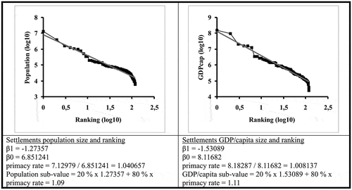
The S value is finally stretched into a 0–100 scale which is constructed using a similar work applied at the European level (Meijers and Sandberg Citation2006). Values closer to 100 indicate low polycentricity while values closer to 0 correspond to a stronger polycentricity degree. Applying the above routine and according to the empirical evaluation range (0–100), population sub-value equals 48.15 and GDP/capita sub-value equals 29.63. Then:(3)
6.1.2. Calculation of the D (dispersion or location value)
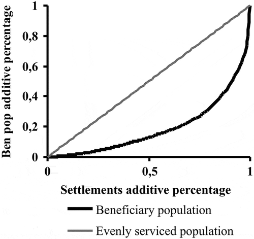
Polycentricity is directly related to the dispersion of settlements in the study area. An absolutely even distribution coincides with high polycentricity while an uneven distribution of concentration of settlements results in greater polarization. To calculate settlements distribution, a method is used based on the concept of ‘beneficiary population’. Beneficiary population is expressed as the population size within a 50 km (45 min) time-distance from a given settlement (service area of daily commuting). In order to assess beneficiary population, GIS network analysis may be used.
The unevenness in distribution of the serviced population per settlement is assessed using the Gini coefficient, which runs between 0 and 100. The value 0 means even distribution and maximum polycentricity wherein all centres have the same beneficiary population, while the value of 100 means the maximum deviation from the ‘ideal’ situation. Essential element for the Gini coefficient calculation is the construction of a Lorenz diagram and the area measurement between two lines. The first one (curved line) represents the actual situation of serviced population per settlement, while the second one reflects the ideal picture of evenly serviced population by all settlements (see Figure ). Doing this routine, Gini coefficient equals 0.6139 or 61.39% using a sample of 118 settlements in the study area.
Figure 4. Lorenz curve of beneficiary population (D value).
6.1.3. Calculation of the C (connection or relations between value)
The same method is used for the C calculation. Polycentricity is reflected in the flows between settlements. Both interdependence and functional specialisation leads to exchanges that can be captured by movements between them. To assess the strength of relations between settlements, a modified SASI model method is used based on the concept of ‘potential attractiveness’ of settlements. Potential attractiveness is calculated by the population size and the aggregated time-distance between a settlement and the rest. Time-distance may be assessed using GIS network analysis.
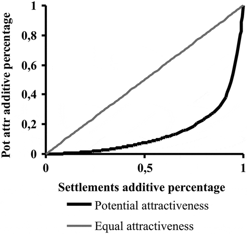
Polycentricity is estimated by calculating the Gini coefficient between the resultant values of potential attractiveness, which runs between 0 and 100. The value 0 means even distribution and maximum polycentricity wherein all centres have the same potential attractiveness while the value 100 means the maximum deviation from the ‘ideal’ situation. Essential element for the Gini coefficient calculation is the construction of a Lorenz diagram and the area measurement between two lines. The first one (curved line) represents the actual situation of potential attractiveness per settlement, while the second one reflects the ideal picture of equal attractiveness of all settlements (see Figure ). Doing this routine, Gini coefficient equals 0.7063 or 70.63% using a sample of 99 settlements in the study area.
Figure 5. Lorenz curve of potential attractiveness (C value).
6.1.4. Assessment of the polycentricity degree in the study area
Aggregating the results from the calculation of S, D and C values, the polycentricity degree (see formula Equation1(1) ) takes the following value which runs in the scale 0–100:
6.2. Composite indicator INT00 potential accessibility between cities and transport terminals
The indicator involves potential accessibility of major cities to main transport terminals in the study area. Potential accessibility depends on the attractiveness of terminals versus the time-distance in order to reach these terminals from the selected cities. It is directly linked to the progress of major infrastructure projects, mainly along the TEN-T and SEETO (South East Europe Transport Observatory) networks, and to the evolution of passenger and freight flows within and across the area.
In specific, the attractiveness of a terminal is expressed by the magnitude of its transport activity, i.e. yearly passenger or freight volume (W
j
). Time distance is given by the friction of time for accessing the terminal from the examined city on the shortest route (d
ij
). A main assumption is that the potential accessibility (A
i
) of the highest populated city at the NUTSΙΙΙ level corresponds to the potential accessibility of the specific NUTSΙΙΙ region. The indicator is given by the formula:(4)
6.2.1. Calculation of W (passenger or freight volume at transport terminals)
The passenger and freight volume handled in a main transport terminal is assessed using respectively the core indicators INT02 and INT03. In the case of passenger transport, the annual passenger volume of main passenger terminals in 106 passengers/year is used. The passenger terminals refer to airports for medium and long distance travel and passenger seaports for medium distance travel. In the case of the transportation of goods, the annual freight volume in 106 tonnes/year is used, while the considered terminals are freight seaports. The railway and inland waterway terminals and the freight centres are excluded due to lack of compatible and reliable data.
A main issue is the selection of main terminals. Taking into consideration that the cross-border area’s transport network comprises TEN-T, SEETO and other infrastructure of different transport modes contributing to various development goals at the international, cross-border and national/regional level, the selection of main terminals was based on different criteria depending on: Existing classification systems; availability of data; existing European and national/regional strategic priorities in the cross-border area. For example, the selection of main freight seaports is based on the TEN-T Class A categorization with an additional threshold for handling a minimum of 2 × 10⁶ t/year, whereas passenger airports servicing a total of more than 15 × 103 passengers/year were included in the selection. These thresholds derive from the analysis of the core indicator INT05 for the specific study area.
6.2.2. Calculation of d (friction of time for city to terminal access)
The friction of time is equal to the time distance between each pair of major city and main terminal in the cross-border area on the shorter-route exclusively by road (core indicator INT01), due to the scope of the study. Based on the approach of the core indicator of polycentricity (POL01), major cities are considered the cities of more than 30 × 103 inhabitants and/or the administrative capitals of NUTSIII regions.
The calculation of time distance is conducted on GIS along the TEN-T, SEETO and Pan-European corridors, the motorways and the national road network using the most recent data available. The time impedance is calculated taking into account different traveling speeds according to the classification of the network, i.e. motorway or national road, and to the type of mode, i.e. truck and passenger vehicle. Different time-losses due to cross-border checks are used whether a border crossing involves an EU member state or a third country.
6.2.3. Assessment of potential accessibility in the study area
Based on the above described methodology, the potential accessibility of each major city to the main passenger and freight terminals is assessed through the composition of the core indicators INT01, INT02 (passenger transport) and INT01, INT03 (freight transport) by implementing formula (Equation4). The methodology adjusts the ESPON’s Potential Accessibility Indicator (ESPON Citation2013b) to the purpose and needs of the current study. The main difference compared to the ESPON methodology is that, with the scope of examining potential accessibility of cities to terminals and not potential accessibility among cities, the destination-terminal’s transport demand instead of the destination-city’s population is used as an attractiveness factor. This leads to the assumption of an adjustment factor (β) equal to 0.1, noticeably higher than the factors used in the aforementioned ESPON studies.
In order to calculate the composite intermodality indicator from the intermodality indicator of each city, the following assumptions are made:
| • | The effect of passenger seaports is regional, servicing remote areas and touristic flows. Their effect may be considered incompatible to the scope of the cross-border study and it is excluded from the composite indicator. | ||||
| • | The importance for passenger transport accessibility in the cross-border area is considered equivalent to the importance for freight transport accessibility. | ||||
Based on the above assumptions, the following process is implemented in order to assess the overall average potential accessibility:
| • | Allocation of maximum and minimum values of potential passenger accessibility as well as of maximum and minimum values of potential freight accessibility in the study area. Calculation of the average value of potential passenger and freight accessibility respectively. | ||||
| • | Conversion of the minimum and maximum values to a ‘0–100’ scale, where the minimum value is 0 and the maximum value is 100, and conversion of the average values to the scale ‘0–100’. | ||||
| • | Attribution of ‘weight factors’ for passenger (X, X = {0.1}) and freight accessibility (1−X). Based on the assumption of equal importance between freight and passenger accessibility, the factor is 0.5 for both in the specific study. | ||||
| • | Calculation of weighted average value of potential passenger accessibility and of the weighted average value of potential freight accessibility. Sum of weighted average values of potential passenger and freight accessibility in order to calculate the potential accessibility of cities to passenger and freight terminals. | ||||
In the scale ‘0–100’ (low potential accessibility – high potential accessibility) the value of the indicator for the study area is 53.88.
6.3. Composite indicator CBC00 territorial cooperation degree
Cross-border cooperation is related to the mobility (exchanges) of people and resources within the study area. Larger exchanges lead to a higher degree of cooperation. The bigger the degree of cooperation, the more coherent the socio-economic system of a given area may be. In this sense, the degree of cross-border cooperation can be expressed in relation to factors that express the nature and the level of the exchanges within.
Such factors are found in the investment flows, the trade flows, the tourism flows and migration. However, it is important to diagnose the level of exchanges inside this area in comparison to the total exchanges with the rest of the world (index of dependency). The higher the value of dependency, the bigger the interrelations are.
The composite indicator of territorial cooperation is formed taken the dependency indices produced by the core indicators of CBC01 Investment flows, CBC02 Trade flows, CBC03 Tourism flows and CBC04 Migration flows. The resultant value aggregates the above-mentioned indices according to the formula (Equation5(4) ).
(5)
More specifically:
| • | The index of investment dependency (CBC01) is expressed as the percentage of the capital invested in the study area from its countries to the total amount of the invested capital coming to the study area from the rest of the world (foreign direct investments as stock). | ||||
| • | The index of trade dependency (CBC02) is expressed as the percentage of the trade volume between the countries of the study area to the total trade volume of the study area with the rest of the world (trade volume = value of imports + value of exports in monetary units). | ||||
| • | The index of tourism dependency (CBC03) is expressed as the percentage of the tourism flow between the countries of the study area to the total tourism flow coming to the study area from the rest of the world (arrivals of non-residents). | ||||
| • | The index of migration dependency (CBC04) is expressed as the percentage of migration between the countries of the study area to the migration flows arrived to the study area from the rest of the world (migration as the incoming movements of foreign citizens). | ||||
The dependency indices are dimensionless and already stretched in a ‘0–100’ scale, as well as the cross-border cooperation degree that is produced through the aggregation of them. The greater the value, the more extended the cooperation. The application gave the following values: 2.88 for the investment dependency index, 15.40 for the trade dependency index, 11.92 for the tourism dependency index and 23.61 for the migration dependency index. Thus, the degree of cross-border cooperation is equal to 13.45.
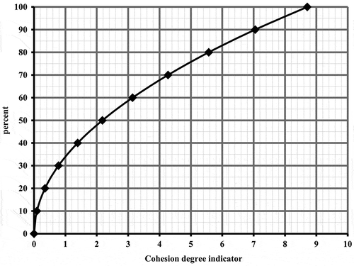
7. Assessment tool
The routine used to calculate the cohesion degree value is based on a triangular diagram (see Figure ) where its three picks represent the parameters of polycentricity, intermodality and territorial cooperation: composite indicators POL00, INT00 and CBC00. Measurement of the triangle’s area (Heron’s formula) is the seeking value for the expression of the cohesion degree. The higher the area value (maximum 8.71–minimum 0) the greater its cohesion potential is. For the interpretation of this numerical outcome, a nomogram is constructed (see Figure ) stretching several triangle values into 0–100% range (see Figure ). Putting the values of POL00 = 43.03, INT00 = 53.88 and CBC00 = 13.45 into the triangular diagram, the resulting area equals 1.05. Using the nomogram, a value of 1.05 indicates cohesion degree of 37% approximately.
Figure 6. Triangular diagram of the cohesion degree.
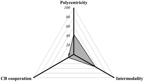
Figure 7. Nomogram for the cohesion degree interpretation.
8. Discussion on the proposed methodology
The present work proposes an integrated routine with the ambition to trigger discussion on a subject that has attracted small attention so far: the modelling of territorial impact of transport in terms of reshaping territorial cohesion. However, the attempt to create a single numerical value expressing the cohesion degree (or potential) of space and the appropriate scale for its interpretation is a task with several conceptual and methodological concerns. Such concerns are discussed below.
8.1. Regarding conceptual aspects
The polycentricity degree of the network of settlements is assessed taken of equal weight the parameters of size – ranking, dispersion or location and connection or relations between. This is a simplified approach in order to build and test the model at the first place, based on similar works regarding polycentricity of space (Wegener Citation2013). There could be further conceptual refinement in order to either verify or even revise this assumption. The same stands also for the degree of cross-border cooperation, where the four sub-parameters are taken of equal weight (1/4 each).
Similarly, during the assessment of potential accessibility, the ability of cities to access passenger and freight transport terminals is considered of equal importance for territorial cohesion in the cross-border area. A change in the scope and purpose of the study would probably lead to a different consideration of the weight of passenger in relation to freight transport accessibility.
The use of a triangular model to calculate the value of territorial cohesion tries to answer the question of the relative weight of each of the parameters of polycentricity, intermodality and cross-border cooperation in shaping the resulting value. The outcome (area of the triangle) interrelate the partial values in a not linear way, overcoming the problem of putting weights to these parameters. After all, a linear approach taking just the sum divided by three would be definitely a simple one but also more demanding in terms of theoretical justification (polycentricity, intermodality and cross-border cooperation contribute equally to the territorial cohesion potential). Further discussion on this topic could probably refine or revise the proposed method.
8.2. Regarding methodological issues
During the calculation of the size – ranking value (S), GDP/capita of the NUTSΙΙΙ capital city is assessed indirectly from the entire NUTSΙΙΙ GDP and population. This is an approach to overcome the lack of reliable data regarding the exact GDP/capita of the settlement (capital city) under discussion. More precise information could lead to a more accurate outcome.
Another issue regarding the better interpretation of the S value is the scale used. The scale was constructed empirically for the purpose of this work having as input relevant research works regarding polycentricity in the entire European space. It is clear that the validity of this empirical scale depends on the quality of the inputs used for its creation along with the method itself (stretching polycentricity value of European countries into a 0–100 scale where 0 is the country with the highest polycentricity and 100 the country with the lowest).
Calculation of the D (dispersion or location) value uses GIS network analysis modelling and the given network of settlements, which stops to the NUTSΙΙΙ capital cities. The more complete the road network (accurate representation, speed limits, impedances etc.) the better the model produced. Moreover, a complete network of settlements could definitely provide better population input to the method used.
During the calculation of the C (connection or relations between) value, the physical fragmentation of the study area (islands and overseas regions: Italian NUTSΙΙΙ) narrowed the selected settlements only to those connected to each other with the road network. Further refinement could incorporate waterborne connections in order to fully explore the connectivity situation.
During the calculation of the dependency indices for the assessment of the cross-border cooperation degree, data taken into consideration refers to country’s level because there was no information available for the region’s performance. Data at regional scale could lead to more accurate understanding about the overall performance of the cross-border area in terms of its cooperation degree (or potential).
In the case of potential accessibility, the use of specific modes’ terminals for each type of transport may be problematic if a mode which currently has insignificant cross-border activity in passenger or freight transport, develops such services in the future. For example, if railway passenger transport in the cross-border area develops, an adjustment of the methodology will be needed. The simplification of not taking into account all modes’ terminals for each type of transport, i.e. passenger and freight, derives from the lack of data. If modes that currently handle mainly freight transport develop significant cross-border passenger service and vice versa, it is expected that detailed data will be collected by transport providers or statistical authorities and an adjustment of the methodology will be feasible.
The overall potential accessibility indicator of the cross-border area is given in relation to the range of potential accessibility values in the study area in a scale of ‘0–100’. This approach is implemented in order to be able to synthesize the results of the cross-thematic synthetic indicators into an expression of the cohesion degree. The examination of the potential accessibility indicator as a separate trend through time, however, requires taking into account the absolute overall value in relation to the range of individual values for each city. In this context, apart from the absolute average value for the study area, a main refinement of the methodology in the future would involve the establishment of a supplementary value measuring the deviation of the absolute individual values presented in the data-set of cities.
9. Conclusions and added value
The assessment of the cohesion degree in the cross-border study area gave the value of approximately 37% for a certain temporal reference. At this stage of the model’s application, the resultant value itself does not say much, since it only gives an idea of the initial situation of this area, a sort of a starting point. A lot more could be assessed if the model is applied in a systematic – temporal basis in order to reveal the general trends along with the partial contributors reshaping territorial cohesion. As described below, specific understandings may also derive from the analysis of each composite indicator.
The degree of polycentricity is expressed as the aggregation of the values produced by the analysis of the network of settlements in terms of size – ranking (S), dispersion or location (D) and connection or relations between (C). In the proportional 0–100 scale, the degree of polycentricity equals 43.03, an average value, meaning that the cross-border area of interest includes factors that either enhance or depress its polycentricity potential. Specific understandings may include the following:
| • | Size – ranking (S) value equals 38.89 (trend towards polycentricity), reflecting a network of settlements with enhanced polycentric characteristics due to the existence of a large number of settlements with high population and similar GDP/capita. | ||||
| • | Dispersion of settlements (D) value equals 61.39 (trend towards polarization), reflecting the fact that some significant urban centres have remarkably bigger potential in servicing the surrounding population. | ||||
| • | Flows between settlements (C) value equals 70.63 (trend towards polarization), meaning that some urban centres have significantly higher attractiveness potential than others at the same hierarchical position in the administrative ranking. | ||||
On the other hand, potential accessibility depends on the attractiveness of terminals (both passenger and freight) versus the time-distance in order to reach them. It may be directly linked to the quality and organization of infrastructure and services and to travel demands. In the proportional 0–100 scale, potential accessibility calculation gave the value of 53.88. The average size of the accessibility potential is mainly formed from the fact that where motorways exist, access becomes a lot easier versus other parts of the study area where the lack of sufficient road infrastructure and incomplete motorway projects create isolation.
Moreover, cross-border cooperation is related to the mobility of people and resources within the study area. The bigger the degree of cooperation, the more coherent the socio-economic system of the examined area is expected to be. By aggregating the parameters of investment, trade, tourism and migration dependencies (relations between the study area countries versus the relations of each country with the rest of the world), the overall assessment of cross-border cooperation gave the value of 13.45 (in the proportional 0–100 scale). This value reflects an overall shallow level of relations. Some countries pose strong convergence with each other while others are actually independent from the relations between.
As for the findings concerning the TIA of the entire study (to which the present model is integrated), the main finding is that the system of the Egnatia motorway and vertical axes improved the accessibility of northern Greece to the markets, the urban agglomerations and the cross-border movements of the wider Balkan mainland, creating the conditions for a new pattern of mobility and a new role for the area’s transport system. This improvement is more evident among the territorial units along which the afore-mentioned system extends, but it is also significant for the wider cross-border area benefited by its operation.
It should be highlighted however that the subsystem of the motorway and its vertical axes is integrated to a wider system of similar road infrastructures and services which operate either in a competitive or a complementary way or even independently from each other. Thus, the role of the Egnatia motorway regarding the level of cohesion in SE Europe significantly depends on the synergy and complementarity of the existing transport subsystems, regarding the service of flows and the interconnection of urban centres and production activities.
Under the seeking of territorial cohesion, the main added value of the proposed model for assessing the cohesion degree in a cross-border area lies upon its possible utilization for backing up policy-makers and decision-making procedures in redirecting development intervention on areas influenced by the creation and operation of large-scale linear infrastructure projects (road, rail), especially those applying on territorial systems that were well fragmented in the recent past (cross border areas).
As a tool for analysis, it could also support the strategic environmental impact assessment (SEA), especially by discussing social and economic implications of large-scale infrastructure projects crossing various territorial systems (cross-border areas) under the prospect of development diffusion (EC Citation2017).
Apart from its usage as a decision-making tool, the proposed model and its implementation routine intervenes with a wide range of scientific components and, as such, it seeks to contribute and drive the academic discussion on conceptual and methodological aspects that could further improve or revise the entire approach in the direction of territorial impact analysis.
Disclosure statement
No potential conflict of interest was reported by the authors.
Funding
This work was supported by the Greek Operation Programme ‘Improvement of accessibility 2007–2013: Technical Support for the Priority Axes of the Community Support Framework’, in the context of funding the Egnatia Odos SA’s contract for the ‘Study of the impacts of the Egnatia Motorway in SE Europe: transport intermodality, polycentric spatial development and cross-border territorial cooperation’ [contract number of reference: 0000/5265/Α01/23.04.2014].
References
- Brezzi M , Veneri P . 2014. Assessing polycentric urban systems in the OECD: country, regional and metropolitan perspectives. OECD Regional Development Working Papers. 2014/01. Paris: OECD Publishing.10.1787/20737009
- Bruinsma F , Rienstra S , Rietveld P . 1997. Economic impacts of the construction of a transport corridor: a multi-level and multi-approach case study for the construction of the A1 highway in the Netherlands. Reg Stud. 31(4):391–402.10.1080/00343409750132991
- Camagni R . 2009. Territorial Impact Assessment for European regions: a methodological proposal and an application to EU transport policy. Eval Progr Plan. 32(4):342–350.10.1016/j.evalprogplan.2009.06.014
- [CEC] Commission of the European Communities . 1999. European spatial development perspective – towards balanced and sustainable development of the territory of the EU; Committee on Spatial Development. Luxembourg: Office for Official Publications of the European Communities. [accessed 2017 Sep 22]. http://ec.europa.eu/regional_policy/sources/docoffic/official/reports/som_en.htm.
- [CEC] Commission of the European Communities . 2002. Communication from the commission on impact assessment. Communication from the Commission to the Council, the European Parliament, the Committee of the Regions and the European Economic and Social Committee; Jun 2002; Brussels, BE. COM(2002) 276 final. [accessed 2017 Dec 12]. http://eur-lex.europa.eu/legal-content/EN/TXT/?uri=CELEX:52002DC0276.
- [CEC] Commission of the European Communities . 2004. Impact assessment: next steps in support of competitiveness and sustainable development. Commission staff working document; Oct 2004; Brussels, BE. SWD(2004) 1377 final. [accessed 2017 Dec 12]. https://encrypted.google.com/url?sa=t&rct=j&q=&esrc=s&source=web&cd=1&ved=0ahUKEwi74JvX3InYAhUBNBQKHaZFBl8QFggnMAA&url=http%3A%2F%2Fec.europa.eu%2Fsmart-regulation%2Fimpact%2Fkey_docs%2Fdocs%2Fsec_2004_1377_en.pdf&usg=AOvVaw2iZrNMO0JiSkeLTTCzek36.
- [CEC] Commission of the European Communities . 2008. Green paper on territorial cohesion. Turning territorial diversity into strength. Communication from the Commission to the Council, the European Parliament, the Committee of the Regions and the European Economic and Social Committee; May 6; Brussels, BE. COM(2008) 616 final. [accessed 2017 Jun 22]. http://eur-lex.europa.eu/LexUriServ/LexUriServ.do?uri=COM:2008:0616:FIN:EN:PDF.
- [CSIL] Centre for Industrial Studies . 2012. The Egnatia motorway – ex post evaluation of investment projects co-financed by the European Regional Development Fund (ERDF) or Cohesion fund (CF) in the period 1994–1999. Report prepared for the European Commission, DG-Regional Policy, Policy Development Evaluation; Milan. [accessed 2017 Dec 12]. http://ec.europa.eu/regional_policy/sources/docgener/evaluation/pdf/projects/egnatia_motorway.pdf.
- [EC] European Commission . 2005. Impact assessment guidelines. Jun 2005; Brussels, BE. SEC(2005) 791/3. [accessed 2017 Dec 12]. https://encrypted.google.com/url?sa=t&rct=j&q=&esrc=s&source=web&cd=1&ved=0ahUKEwjrzNX_3YnYAhWKOhQKHZd7DPMQFggsMAA&url=https%3A%2F%2Fec.europa.eu%2Fagriculture%2Fsites%2Fagriculture%2Ffiles%2Fsfs%2Fdocuments%2Fdocuments%2Fsec2005-791_en.pdf&usg=AOvVaw0f-wxJz1Dsgn7-0NFd6CQj.
- [EC] European Commission . 2009. Impact assessment guidelines. Jan 2005; Brussels, BE. SEC(2009) 92. [accessed 2017 Dec 12]. https://encrypted.google.com/url?sa=t&rct=j&q=&esrc=s&source=web&cd=1&cad=rja&uact=8&ved=0ahUKEwjP7rK63onYAhWCchQKHfVVBp0QFggsMAA&url=http%3A%2F%2Fec.europa.eu%2Fsmart-regulation%2Fimpact%2Fcommission_guidelines%2Fdocs%2Fiag_2009_en.pdf&usg=AOvVaw3JwpmCIsiLqOQkJiuEmu9s.
- [EC] European Commission . 2011a. White paper: roadmap to a single European transport area – towards a competitive and resource efficient transport system; Mar 28; Brussels, BE. COM(2011) 144 final. [accessed 2017 Jun 22]. http://eur-lex.europa.eu/legal-content/EN/TXT/PDF/?uri=CELEX:52011DC0144&from=EN.
- [EC] European Commission . 2011b. A new response to a changing neighborhood. Joint communication to the European Parliament, the Council, the European Economic and Social Committee and the Committee of the Regions; May 25; Brussels, BE. COM(2011) 303 final. [accessed 2017 Jun 22]. http://eur-lex.europa.eu/legal-content/EN/TXT/?uri=celex:52011DC0303.
- [EC] European Commission . 2013a. Assessing territorial impacts: operational guidance on how to assess regional and local impacts within the Commission Impact Assessment System. Commission staff working document; Jan 2013; Brussels, BE. SWD(2013) 3 final. [accessed 2017 Dec 12]. http://ec.europa.eu/smart-regulation/impact/key_docs/docs/cswd_ati_en.pdf.
- [EC] European Commission . 2013b. Regulation (EU) No 1315/2013 of the European Parliament and of the Council of 11 Dec. 2013 on Union guidelines for the development of the trans-European transport network. Strasburg: Official Journal of the European Union. [accessed 2017 Jun 22]. http://publications.europa.eu/resource/cellar/f277232a-699e-11e3-8e4e-01aa75ed71a1.0006.01/DOC_1.
- [EC] European Commission . 2015. Territorial agenda 2020 put in practice. Enhancing the efficiency and effectiveness of Cohesion Policy by a place-based approach. Luxembourg: Publications Office of the European Union. [accessed 2017 Dec 18]. http://ec.europa.eu/regional_policy/en/newsroom/news/2015/07/territorial-agenda-2020-put-in-practice.
- [EC] European Commission . 2017. Report from the Commission to the Council and the European Parliament under Article 12(3) of Directive 2001/42/EC on the assessment of the effects of certain plans and programmes on the environment. May 15; Brussels, BE. COM(2017) 234 final. [accessed 2017 Dec 18]. http://eur-lex.europa.eu/legal-content/EN/TXT/?qid=1494874134751&uri=COM:2017:234:FIN.
- Egnatia Odos Observatory . 2015. Study of the impacts of the Egnatia motorway in SE Europe: transport intermodality, polycentric spatial development and cross-border territorial cooperation. Egnatia Odos SA, Contract Number of reference: 0000/5265/Α01/23.04.2014. Contractors: ‘Tsakiris S & Moysiadou T’. Thessaloniki, GR: Egantia Odos Observatory. [accessed 2017 Jun 22]. http://observatory.egnatia.gr/06_extras/6_1_1_results_ZoneV.htm. Mostly Greek.
- [ESPON] European Spatial Planning Observation Network . 2005. ESPON 2.1.1. Territorial impact of EU transport and TEN policies. Final Report – Version 31/03/2005. [accessed 2017 Dec 12]. https://www.espon.eu/sites/default/files/attachments/fr-2.1.1_revised_0.pdf.
- [ESPON] European Spatial Planning Observation Network . 2010. TIPTAP – territorial impact package for transport and agricultural policies. Final Report – Version 11/02/2010. [accessed 2017 Dec 12]. https://www.espon.eu/sites/default/files/attachments/Final_Report_Part_A-B.pdf.
- [ESPON] European Spatial Planning Observation Network . 2012. Ulysses: using applied research results from ESPON as a yardstick for cross-border spatial development planning. Targeted Analysis 2013/2/10, Scientific Report for the Final Report. Multi-Thematic Territorial Analysis of the Greece-Bulgaria Cross-border Area. Version 30/07/2012. [accessed 2017 Sep 22]. https://www.espon.eu/programme/projects/espon-2013/targeted-analyses/ulysses-using-applied-research-results-espon.
- [ESPON] European Spatial Planning Observation Network . 2013a. EATIA. ESPON and Territorial Impact Assessment. Final Report. Version 29/06/2012. [accessed 2017 Dec 18]. https://www.espon.eu/sites/default/files/attachments/FinalReportEATIA28June2012Afinal.pdf.
- [ESPON] European Spatial Planning Observation Network . 2013b. Transport accessibility at regional/local scale and patterns in Europe (TRACC). Applied Research 2013/1/10. Final Report – Version 06/02/2015. Volume 4. TRACC Accessibility Indicator Factsheets. [accessed 2017 Sep 22]. https://www.espon.eu/programme/projects/espon-2013/applied-research/tracc-transport-accessibility-regionallocal-scale-and.
- Fischer TB , Gore T , Golobiĉ M , Marot N . 2013. Territorial Impact Assessment – a new policy assessment tool to support territorial cohesion. Proceedings of the IAIA13 Conference; May 13–16; Calgary, Alberta, Canada.
- Fischer TB , Sykes O . 2009. The ten-t – an environmental pitch. Town Country Plan. 78(4):194–196.
- Fischer TB , Sykes O , Gore T , Marot N , Golobič M , Pinho P , Waterhout B , Perdicoulis A . 2015. Territorial Impact Assessment of European draft directives – the emergence of a new policy assessment instrument. Eur Plan Stud. 23(3):433–451.10.1080/09654313.2013.868292
- Fourkas V . 2015. Χωρικές επιδράσεις της Εγνατίας Οδού: Αποτελέσματα και εκτιμήσεις 2005-2015 [Spatial impacts of Egnatia motorway: results and estimations 2005–2015]. In: Proceedings of the Conference ‘15 years of Egnatia Odos motorway Observatory: Monitoring and Evaluating the Spatial Impacts of Transport’; Nov 24; Thessaloniki, GR, EGNATIA ODOS SA. p. 43–60. Greek.
- Fourkas V , Yiannakou A , Seitanidis S , Troulinos M . 2010. Trans border movements in northern Greece: seeking for spatial interactions. Proceedings of the 2010 European Conference of the Association for Borderland Studies; Sep 23–25; Veroia, GR: Department of Spatial Planning and Development at the Aristoteleion University of Thessaloniki.
- Gløersen E . 2008. Quantifying polycentricity. Workshop on Territorial Indicators and Indices; May 2; ESPON Coordination Unit, Esch-sur-Alzette; Luxembourg. [accessed 2017 Jun 22]. https://www.espon.eu/sites/default/files/attachments/Erik-Gloersen-ESPON-W-Indicators-April-2008.pdf.
- Golobič M , Marot N , Kolarič Š , Fischer TB . 2015. Applying Territorial Impact Assessment in a multi-level policy-making context – the case of Slovenia. Impact Assess Proj Appraisal. 33(2):43–56.10.1080/14615517.2014.938438
- Laedre O , Haavaldsen T , Bohne RA , Kallaos J , Lohne J . 2015. Determining sustainability impact assessment indicators. Impact Assess Proj Appraisal. 33(2):98–107.10.1080/14615517.2014.981037
- Lopez E , Guitierrez J , Gomez G . 2008. Measuring regional cohesion effects of large-scale transport infrastructure investments: an accessibility approach. Eur Plan Stud. 16(2):277–301.10.1080/09654310701814629
- Meijers E , Sandberg K . 2006. Polycentric development: panacea for regional disparities in European countries. Response paper presented at the 10th UNECE Conference on Urban and Regional Research; May 22–23; Bratislava, SL.
- Nordregio . 2005. ESPON 1.1.1: potentials for polycentric development in Europe. Project Final Report. Stockholm/Luxembourg: Nordregio/ESPON Monitoring Committee. [accessed 2017 Jun 22]. https://www.espon.eu/sites/default/files/attachments/fr-1.1.1_revised-full_0.pdf.
- Peters D . 2003. Cohesion, polycentricity, missing links and bottlenecks: conflicting spatial storylines for pan-European transport investments. Eur Plan Stud. 11(3):317–339.10.1080/09654310303638
- Racz S . 2014. Urban networks, capital regions and spatial development in the Balkan states. In: Kadar B , Lazar E , editors. Economical environment changes in the Carpathian Basin. Miercurea-Ciuc: Editura Status; p. 206–227.
- Wegener M . 2013. Polycentric Europe: more efficient, more equitable and more sustainable? Paper presented at the International Seminar ‘Welfare and Competitiveness in the European Polycentric Urban Structure: Which Role for Metropolitan, Medium and Small Cities?’; Jun 7; Florence, IT: Istituto Regionale Programmazione Economica dellaToscana (IRPET).