
ABSTRACT
Ecological connectivity within and across the boundaries of protected areas has become a key theme for conservation practitioners in Canada and internationally in recent years. This paper describes four case studies involving the assessment of ecological connectivity in national parks in Canada. Assessments occurred in three tiers: strategic environmental assessments conducted during management planning processes, an intermediate tier focussed on research and partnering at more refined spatial scales, and project level environmental impact assessments. While improved data, modelling and research on thresholds is needed, the multi-tiered approach facilitated the analysis of information and the collaboration with partners at scales required to conserve ecological connectivity within and across the boundaries of national parks. This work demonstrates practical approaches to conserving ecological connectivity as a response to biodiversity loss and highlights impact assessment in multiple tiers as a solution that is transferable to other sectors.
Introduction
Ecological connectivity refers to ‘the unimpeded movement of species and flow of natural processes that sustain life on earth’ (CMS Citation2020; Hilty et al. Citation2020). Within a given area, ecological connectivity is influenced by a wide range of factors including the configuration of the natural landscape, the degree and type of habitat fragmentation resulting from human activity, the size and location of protected areas, and the characteristics and needs of the species present, to name but a few (Hilty et al. Citation2020). It has become widely recognized that conserving ecological connectivity at the landscape scale, including between protected or conserved areas, is essential to successfully conserve biodiversity, particularly in the context of climate change (World Business Council for Sustainable Development (WCBSD) Citation2017; Tabor et al. Citation2019). This is because ecological connectivity can promote genetic flow and exchange, enable species to access preferred habitat and expand their range, enhance interaction between species, and help mitigate the impact of disturbance like fire (Ament et al. Citation2014; Hilty et al. Citation2020). The importance of ecological connectivity is highlighted in the landmark report One with Nature (Citation2018) that called on Canadians to ‘work together to design and implement coordinated, connected, representative and effective networks of protected and conserved areas throughout Canada, recognizing that this will be a long-term endeavour and will not be completed by 2020’ (p. 32).
The practical requirements for maintaining or restoring ecological connectivity within and between new and existing protected areas have become a central theme of conservation planning in Canada and around the world. The literature has a growing number of recent contributions that address various dimensions of this theme including approaches to mapping and measuring ecological connectivity, planning considerations and best management practices (Ament et al. Citation2014; Keeley et al. Citation2019, Citation2021; Belote et al. Citation2020). A key theme that has emerged from this literature is the importance of understanding and conserving connectivity at a variety of complementary spatial scales that reflect the movement and dispersal needs of different species as well as the different tiers at which conservation planning takes place (Keeley et al. Citation2018; Hilty et al. Citation2020; Lemieux et al. Citation2021).
The present article builds on this literature by considering the contributions of multiple tiers of assessment, including strategic environmental assessments (SEAs) of park management plans and project environmental impact assessment (EIA), in identifying threats and opportunities for connectivity conservation. More specifically, we discuss how potential impacts on ecological connectivity are increasingly being assessed in the context of national park management planning and projects. We describe two tiers of assessment, SEAs and project EIA, and a proposed approach to linking them via an intermediary tier. We demonstrate how management plans and SEAs inform each other and provide a framework for project EIA that may follow within the period of the management plan. We emphasise the role of SEAs in diagnosing gaps and opportunities to build knowledge and partnerships required to implement appropriate mitigations and to conduct evidence-based project EIAs as required. We also reflect on some of the conceptual and practical challenges experienced in the course of this work, which is part of a broader effort by Parks Canada to modernize conservation programs and policies.
Impact Assessment Context
Canada has 47 national parks ranging in size from 14 km2 to 45,000 km2 (Environment and Climate Change Canada (Citation2020)). National parks are representative of natural regions and protect the assemblage of species, habitat types and ecological relationships that are characteristic of the region with which they are associated (Parks Canada Citation1997, Citation2017). The Canada National Parks Act requires each national park in Canada to have a management plan and this plan to be updated every 10 years. Management plans set the strategic direction for national parks including how they will meet the legislated requirement to prioritise the maintenance or restoration of ecological integrity in all aspects of park management.
The Cabinet Directive on the Environmental Assessment of Policy, Plan and Program Proposals (Privy Council Office and Canadian Environmental Assessment Agency Citation2010) requires an SEA to be conducted on all national park management plans. Management plan SEAs seek to identify the cumulative effects (and associated mitigations) relative to four key areas of risk to the ecological integrity of national parks: i) activities and infrastructure within the park, ii) visitation, iii) climate change, and iv) activities and other pressures outside of the park. In this context, ecological connectivity has emerged as a cross cutting theme, not only given its aforementioned importance to conservation, but because all four areas of risk identified can have an impact on ecological connectivity in different ways and at different scales.
SEAs are focused around a prioritized set of valued components. Valued components are identified from the ecological integrity monitoring program, species at risk, other conservation priorities and interests of the public and Indigenous Peoples. The SEA focuses on valued components where Parks Canada has the greatest opportunity to make a difference for conservation by considering the risk to the valued component and the tools available to manage it. After selecting the valued components, the need to examine connectivity as part of the analysis is determined based on the threats and ecological needs. In some cases, particularly with smaller parks, the SEA may focus on connectivity because of the importance to all valued components. Subsequent project EIA is conducted pursuant to applicable legislation, including the Impact Assessment Act, which does not include connectivity as a required theme for analysis. However, the legislation does not preclude connectivity from being considered if it is highlighted as a key theme in the SEA.
SEAs of national park management plans are ‘nested’ (Noble and Nwanekezie Citation2016) in the sense that they provide the analysis to support good decision-making in the management plan as well as identifying direction for future project EIA. While some contributions to the SEA literature do not emphasize the role of SEA in supporting subsequent project EIA (Therivel and González Citation2019), others make a point of emphasizing this link (Fischer Citation2006; Marshall and Fischer Citation2006; White and Noble Citation2013; Noble and Nwanekezie Citation2016; Fisher and González Citation2021). Noble and Nwanekezie (Citation2016) identify the ‘nested’ nature of SEA as one of the strategic principles of SEA. ‘Nesting’ refers to the relationship of the SEA to other initiatives and processes, including higher-tiered policies, programs and plans and lower-tiered project EIA. White and Noble (Citation2013) identify a common trend in the literature towards sustainability ‘trickling down’ to project EIA. Fischer (Citation2006) more specifically highlights the connections between different tiers of assessment and spatial scale. Spatial scale was associated both with the subject of the assessment (national policy, regional network plans, corridor plans within them, investment programmes, and projects) and with the relevance of impacts (local, regional or global scale) of transportation planning. Given the importance of scale in understanding, assessing and protecting connectivity, an exploration of the role of different tiers of assessment in assessing connectivity is relevant to protected area management. It also responds to the recommendation from Noble and Nwanekezie (Citation2016) that ‘if SEA of any approach is to be influential in influencing decisions and actions, the notion and practice of tiering in SEA, particularly the institutional arrangements needed to ensure effectively tiered processes, needs to be revisited by the scholarly community (p171).’
Case Studies
Methodology
While utilizing different tiers of assessment to assess impacts on ecological connectivity can be beneficial in theory, in practice, it can be more difficult to ensure that the strengths of each tier are maximized and linkages between tiers are made clear. We selected case studies of Parks Canada’s use of SEA associated with site management plans to help explore these challenges. Case studies were selected based on three criteria. First, case studies were recent and therefore represented most up-to-date practice. Second, the case studies were geographically dispersed and therefore more likely to represent different types of ecological and management challenges. Third, the case studies were selected based on their ability to provide insight into the tensions and solutions for tiering assessments.
In the case studies that follow, we offer practical examples of how different tiers of assessment were used to determine impacts on connectivity at different spatial scales relevant to the ecological, social and economic contexts of different parks across Canada. We identify when each tier is utilized, the contribution of the tier to the nested assessment process and linkages between tiers, when applicable. Following the case studies, we discuss how they illustrate a general framework for the tiered environmental impact assessment process at Parks Canada.
Case study 1: Mount Revelstoke and Glacier National Parks
Mount Revelstoke and Glacier National Parks are located in Western Canada and due to their close proximity and similar ecosystem types in the Columbia Mountains, they are managed together. These two parks cover over 1600 km2 and represent the Columbia Mountains Natural region within Canada’s national park system. They protect a variety of ecosystems ranging from old growth inland rainforest to alpine tundra.
Grizzly bear and other carnivores like wolf, cougar, lynx and wolverine are wide-ranging species found in these parks. However, given the size of these parks, they are unlikely to contain the full home range of many individuals of these species, let alone a whole population. For example, wolves have been shown to range over 1,058 to 3,374 km2 in this area and male wolverines can have a range of over 1,366 km2 (Apps Citation2020). As a result, transboundary connectivity between the park and secure habitat outside park boundaries is important for these species to meet life-cycle requirements, find mates and facilitate an overall healthy population.
An analysis of connectivity conservation priorities for grizzly bears and other carnivores was conducted as a supporting study for the SEA of the management plan (). The study used a least-cost multi-pathway analysis based on multi-species habitat potential and associated movement permeability (Apps Citation2020). Linkage zones were ranked and scored according to conservation priority. High priority areas represented those areas with the greatest potential benefit towards long-term conservation of ecological connectivity across national park borders (Apps Citation2020).
Figure 1. Map showing priority areas for carnivore connectivity between Mount Revelstoke and Glacier National Parks and surrounding landscapes. The analysis used a least-cost multi-pathway analysis based on multi-species habitat potential and associated movement permeability (Apps Citation2020).
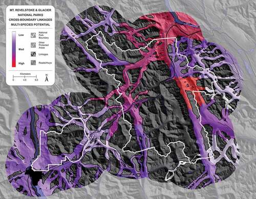
The draft SEA of the draft management plan also identified that there were information gaps about both grizzly bear and visitors. Secure habitat modelling for grizzly bears did not occur and no population level data have been collected for the park. In addition, while data are available about the total number of visitors to the parks, there are limited data about where visitors choose to spend their time within the parks. As a result, while mapping habitat connectivity was possible, there was not enough information about the local population status of grizzly bears nor information on disturbance levels from visitors to fully evaluate impacts on connectivity.
During the management planning process, proposals were identified for new multi-day hiking options and other increased offers for visitors as part of an overarching objective to increase park visitation. Some of these proposals were in the areas identified as high vulnerability for grizzly bears and other carnivores (Apps Citation2020). Given the timelines and complexity of issues associated with management plans, further research, planning and collaboration with partners are required to determine if and how these proposals could proceed without affecting priority areas for connectivity. As a result, the draft SEA and draft management plan committed to research, planning and working with partners on these issues.
The draft management plan committed to further research patterns of visitor use and vehicle traffic as well as collecting baseline data on sensitive wildlife and vegetation communities. This information will be critical for the detailed analysis of connectivity needs and understanding current and future impacts of connectivity at a finer scale.
In terms of spatial planning, the draft SEA identified two areas where connectivity conservation and visitation priorities overlap, thereby necessitating a more detailed area-based planning approach. The draft plan commits to a comprehensive needs and feasibility assessment and options analysis for these two areas. In each of these locations, the conservation priority is high, but more detailed analysis as part of these planning efforts will be able to evaluate the fine-scale connectivity requirements of carnivores, based on new research, which may provide opportunities to ensure quality connectivity at the same time as providing quality visitor experiences.
The draft plan commits to working with local Indigenous Peoples, local tourism stakeholders and neighbouring land managers to identify priority areas to manage for connectivity. In order for effective connectivity to be conserved, neighbouring land managers will need to take actions as well. Given this work needs to take place at a more local scale, not all of the groups involved in consultation on the management plan may be involved, but rather a subset whose interests are in specific areas. The hope is that approaches to protecting connectivity at a regional scale can be identified collaboratively.
Future project EIAs will ensure that project design and mitigation have incorporated the findings of the SEA and the subsequent research and planning. For example, in areas where the SEA or follow-up work suggest that connectivity conservation and increased visitation may be compatible, the EIA would consider the best location within general areas of connectivity to place facilities such that they minimize the impact on connectivity. Similarly, food cache and waste disposal options and locations would be identified to reduce wildlife attractants and minimize conflict. New activities such as mountain biking or e-biking could be evaluated for the additional contributions to cumulative effects on connectivity.
While the draft SEA identified a group of species with connectivity challenges, the locations where connectivity was a concern and future projects that may impact connectivity, it was not able to provide specific directions to project EIA. That is to say, it did not offer design parameters for projects, thresholds for activity in key corridors or even the key characteristics of the corridors that needed to be maintained when projects occurred. Additional data gathering, planning and collaboration will be needed before that is possible. However, if the SEA had not been completed, project EIAs of small projects may not have identified the challenges to connectivity or had the time and resources to conduct the analysis needed to characterize the issue. The proactive identification of the challenges in the SEA should result in project proposals with fewer or no impacts on ecological connectivity and simpler and more effective project EIAs.
Case study 2: Kluane National Park and Park Reserve
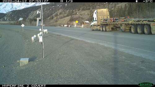
Kluane National Park and Park Reserve are located in northwestern Canada next to the Alaska border. It covers more than 22,000 km2 of montane forest, alpine tundra and continental ice fields. The park is home to several populations of Dall’s sheep, an iconic species of high importance to Indigenous and non-Indigenous people in the Yukon. While the park protects enough habitat to maintain several populations of Dall’s sheep within its boundaries, the Thechàl Dhâl population inhabits an area along the park border, meaning that sheeps from this population move in and out of the park on a regular basis. The draft SEA for the draft park management plan identified Dall’s sheep as a valued component and the highway that runs along the base of Thechàl Dhâl (a mountain) as a major obstacle to connectivity for the resident population of sheep (). This obstacle to connectivity has resulted in regular roadway mortality and, in 2018, a single incident resulted in 12 sheep being hit and eight were killed. This corresponds to 4% of the lambs from this population on the year in question.
Figure 2. Dall’s sheep on the Alaska Highway adjacent to Kluane National Park and Park Reserve. Collisions with vehicles are a common cause of mortality for the local sheep population and research is underway to understand sheep movement patterns as a basis for mitigating highway mortality.
The draft SEA found that commercial traffic is expected to increase on the highway, further exacerbating the obstacle to connectivity and associated risks to Dall’s sheep in this area. In addition, climate change may contribute to mortality of alpine ungulates as spring temperatures are anticipated to increase and precipitation patterns will change, which may negatively affect alpine ungulate recruitment and survival. As a result, the mortality on the highway may become a more significant factor affecting the population as a whole.
The draft SEA identified information gaps in understanding sheep behaviour at the highway. The lack of understanding about connectivity requirements driving sheep behaviour at the highway makes it more difficult to identify solutions. As a result, a remote camera-based monitoring project has been started to better understand sheep movement patterns on an annual basis, including where and when they cross the highway. In this case, the connectivity-related issue and information gaps identified by the draft SEA informed a subsequent initiative to generate knowledge that could inform mitigation actions for an ongoing issue of management concern as well as EIAs associated with future projects that may have an impact on sheep movement in the area.
Future work will involve using the knowledge gathered in collaborative conservation planning for this sheep population with the Champagne and Aishihik First Nations and the Kluane First Nation (with whom the park is collaboratively managed) and other partners, including the Dan Keyi Renewable Resource Council and the Yukon Territorial Government.
Case study 3: Point Pelee National Park
Point Pelee National Park is located at the most southerly point in Canada on Lake Erie. At only 15.2 km2, it is one of the smallest national parks in Canada, but protects diverse and rare habitat types associated with the Carolinian ecozone as well as many species at risk listed under the Species at Risk Act.
Connectivity is important at Point Pelee in multiple dimensions. First, the park is an important stop on the flyway for migratory birds, being the first point of land after birds fly over Lake Erie. As just one stop on a long migration route, other stops are also important in maintaining the connectivity of the flyway. Second, marsh habitats make up a large proportion of the park’s habitat. The aquatic connectivity of this marsh habitat to neighbouring areas has historically been severed by wetland conversion to farmland, causing habitat connectivity issues for fish and turtles. Third, the park is a hotspot for herptiles. Given the small size of the park, some of the herptiles have dispersal distances well beyond the park size (Hecnar and Hecnar Citation2004), yet intensive farmland poses a movement barrier between the park and intact herptile habitat further to the north.
The draft SEA for the draft park management plan identified these connectivity issues and highlighted the need for better regional information to facilitate connectivity, particularly for herptiles. However, it is also clear from the size of the park and surrounding land uses that connectivity is something that needs to be addressed in large part by neighbouring jurisdictions. To support facilitating connectivity at the regional scale, the draft management plan commits Parks Canada to contributing expertise and support as an active participant in regional land use planning initiatives. As part of this commitment, Parks Canada is funding a landscape analysis by the Essex Regional Conservation Authority that includes mapping natural heritage features and vegetation communities, as well as habitat for species at risk and species of conservation concern, in landscape units adjacent to the Point Pelee National Park.
The purpose of this work is to provide an evidence base for efforts to improve connectivity between the park and key habitat patches in Essex County as well as support collaborative conservation planning in the region more generally.
Given that the connectivity issues identified by the draft SEA for the draft Point Pelee Management Plan relate largely to land use adjacent to park boundaries, it is unlikely that the draft SEA will lead to substantive connectivity gains by virtue of its role in guiding project-level EIAs within the park. This is because projects conducted within the park during the term of the management plan are likely to have a far lesser influence over connectivity when compared to ongoing land use neighbouring the park. That said, the draft SEA has nonetheless helped set a strong agenda for connectivity conservation by prompting the park to develop and implement commitments to engage in connectivity planning at the regional scale. By working with the Essex Regional Conservation Authority and other partners in the surrounding landscape, it is possible to determine opportunities to restore connectivity between the park and habitat patches to the north, as well as consider how conservation and restoration of habitat outside the park can complement efforts within the park to support recovery of species at risk.
Case study 4: Kouchibouguac National Park
Kouchibouguac National Park is located in Eastern Canada. It is 238 km2 and represents the Maritime Plain Natural Region, which is characterized by a flat-to-undulating landscape of low elevation, underlain by relatively soft sandstone, conglomerate, and shale. The ecosystems of the park support a variety of species including toads, frogs, salamanders, snakes and turtles (such as the threatened Wood Turtle), as well as small mammals such as mice and shrews.
The main road passing through the park is route 117, which extends 24 km from the park’s south entrance to the community of Pointe Sapin to the north. The road is located in an area of flat terrain with many locations characterised by slow drainage due to the flat slope, particularly the northern portion of the road. Route 117 was built during the 1960s. In 2015, rehabilitation of route 117 was proposed. The project included rebuilding the entire road from the sub-grade to new asphalt over a length of 23.7 kilometres. A total of fifty-eight (58) culverts had to be removed and replaced for which twenty-eight (28) were considered as fish habitat.
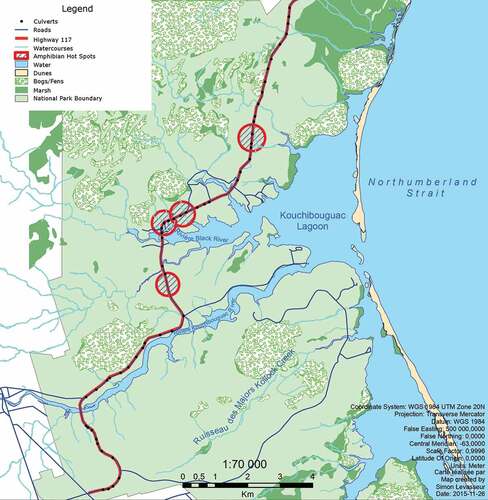
The road had been the subject of substantial research into responses of the amphibian movement to variations in both traffic and weather (Mazerolle Citation2004; Gravel et al. Citation2012). Among other findings, the research identified hot spots for amphibian mortality along the road (). In addition, culverts along the road were no longer the appropriate size to accommodate flooding and lacked support for fish habitat and migration. Six brooks did not facilitate any fish passage. However, amphibians and aquatic connectivity were not identified as issues in an SEA of the park management plan. This is because species with connectivity issues along the road were not identified in the ecological integrity monitoring program because they are not representative of the ecological integrity at the park scale.
Figure 3. Map showing locations where amphibians frequently cross highway 117 in Kouchibouguac National Park. The highway is a cause of mortality and significant barrier to habitat connectivity for a range of species on the park.
As a result, at a whole park scale, the issues of connectivity along the road were not important enough to be addressed in the SEA. A lack of analysis at the SEA tier did not mean that it was not needed in the project EIA or that the project EIA could not perform the assessment well. Given that the issues were more local in scale, project EIA was the appropriate tier for assessment to effectively address these connectivity challenges. Through the project EIA and design, opportunities to improve connectivity for amphibians and fish were identified. Four crossings for amphibians and small mammals were installed. In addition, 1455 m2 of new fish habitat was created and six brooks that previously did not permit fish passage were reconnected. As a result of these measures, the barriers to connectivity created by the road were reduced significantly.
Discussion
While tiered assessment often focuses on SEAs and project EIAs (Gibson et al. Citation2016), other analyses have demonstrated that tiering can be more complex and involves multiple levels (Fischer Citation2006; Marshall and Fischer Citation2006; Faith-Ell and Fischer Citation2021; Fisher and González Citation2021; Gesa Geißler et al. Citation2021). The case studies outlined in this paper support this more complex view, demonstrating that in many circumstances, another tier is needed for effective impact assessment and implementation (). Connectivity issues relative to valued components were often analyzed in the SEA of the management plan, but the scale of the analysis was often too broad and complex to adequately inform project EIAs that follow during the term of the management plan. As a result, additional research and planning was often required with partners in specific locations to generate enough information to effectively assess projects for their potential impacts on ecological connectivity. This research and planning tier operates at a broader scale than individual project EIAs and can be relevant to multiple project EIAs.
Figure 4. Contributions of each assessment tier to support subsequent tiers in assessing ecological connectivity in national parks.
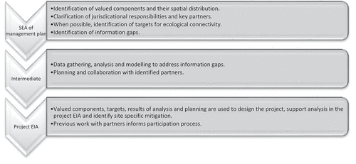
SEAs
The SEA is at the widest scale and identifies species that have connectivity requirements that need analysis at a landscape scale. It identifies corridors or connections that are vulnerable to cumulative effects for further consideration in the subsequent tiers. The SEA is also well positioned to identify information gaps that might need to be filled before project EIAs would be able to adequately mitigate effects on connectivity. Finally, the SEA highlights responsibilities of different jurisdictions over factors affecting connectivity in the broader landscape and identifies Parks Canada’s role in connectivity conservation. These findings support the potential identified by Gonzalez (Citation2021) for SEAs of land use plans to analyse cumulative effects, including those on ecological connectivity. Furthermore, the role of SEA found here is similar to a combination of the policy and plan tiers found by other authors (Fischer Citation2006; Marshall and Fischer Citation2006; Faith-Ell and Fischer Citation2021; Gesa Geißler et al. Citation2021).
Intermediate tier
Before moving to project EIAs, an intermediate tier is often needed. This tier is intermediate in terms of both spatial and temporal scales. It operates at a spatial scale that is smaller than the full park, but larger than most projects requiring EIA. Temporally, it occurs after the SEA, but before a project EIA. The complexity of working through multiple issues at the scale of the management plan means that while the SEA is effective at highlighting issues, additional work is often required prior to the implementation of some of the direction within a project-level EIA. In the intermediate tier and scale, work could include research to understand connectivity needs and solutions. It could involve planning at the more local spatial scale and it could require processes to work with partners on an agreed upon direction. These partners, some of whom would have responsibilities for connectivity outside the park, may be a subset of those that would have been involved in developing the management plan as the focus is now at a more local scale. This tier is similar to plan and/or corridor plan (Fischer Citation2006) and plan/program SEA (Marshall and Fischer Citation2006).
Project EA
Projects can be designed based on the information developed in the previous two tiers to avoid impacts on connectivity as much as possible. Project EIAs would then include analysis on priority VCs and identify site-specific mitigations. However, not all projects that may impact connectivity require an impact assessment under legislation. Furthermore, inclusion of connectivity considerations in project EIA is still important even if not highlighted by the SEA.
Assessments at multiple scales
As the case studies and framework demonstrate, to be effective at conserving ecological connectivity, impact assessments are needed at multiple scales. Assessments at multiple scales are particularly important when a given species is wide-ranging within park boundaries or regularly moves across park boundaries to access habitat within and outside the park. In cases where species occupancy is relatively nucleated within park boundaries, assessment at multiple scales may not be required as it will be sufficient to assess impacts on connectivity at a single scale within the context of a project EIA. When assessments are warranted at multiple scales, it is particularly important to ensure a line of continuity between the broadest tier of assessment (SEA) and the most specific tier (project EIA) through inclusion of an intermediate tier, when needed, that seeks to fill knowledge gaps and address limitations identified by the SEA as being important in the context of project EIA.
This finding offers a hopeful direction for protecting or restoring ecological connectivity. Gonzalez (Citation2021) noted that land use plans, more generally, have the potential to enhance connectivity and highlighted the opportunity for using SEA for assessing cumulative effects. The case studies in this paper demonstrate the practical possibilities of assessing cumulative effects in the context of planning and therefore highlight the potential for doing this in other land use planning processes, the most common application of SEA (Gonzalez Citation2021). As described above, the tiers described in these case studies are similar to those found in transportation and energy sectors (Fischer Citation2006; Marshall and Fischer Citation2006; Faith-Ell and Fischer Citation2021; Gesa Geißler et al. Citation2021). Both these industries include linear developments with large potential for creating obstacles for ecological connectivity across broad regions. Using tiers of assessment provides an excellent opportunity to include the assessment of ecological connectivity at different scales and proactively identify solutions.
Challenges and opportunities
The case studies reveal that there are a number of challenges and opportunities with respect to improving our ability to conduct assessments of impacts on connectivity at multiple scales. The first challenge is a frequent lack of landscape scale connectivity models that can directly inform the assessment of impacts on connectivity relative to the specific-valued components that are the focus of a given SEA. As a result, it is often necessary for commission connectivity analyses tailored to the relevant valued components. In the case of Mount Revelstoke and Glacier National Parks, this was done as part of the SEA process and in the other cases, this will be done in the second tier. Development of reliable, low-cost and non-invasive techniques to effectively map and model ecological connectivity for wide-ranging species will help fill this gap. For example, the use of growing arrays of remote wildlife cameras as a basis for measuring occupancy and connectivity offers considerable promise for informing environmental impact assessment (Steenweg et al. Citation2017).
The second challenge, which builds on the first, relates to the need for inter-jurisdictional coordination and collaboration in assessing connectivity for transboundary species. In three of the four cases, multiple jurisdictions were involved. The availability, quality and type of data needed to support connectivity analyses vary across jurisdictions and strong working relationships between organizations are required to expediently assess impacts on connectivity when SEAs or project EIAs are needed.
The third challenge is that ecological monitoring programs are only starting to develop measures to track status and changes to connectivity with respect to focal species or habitat types. As a result, despite being part of a national park system with a national monitoring program, the approach to including connectivity in SEAs has unique methodology each time. In the future, the availability of this information will provide a useful starting point for environmental assessment in the context of national parks.
Two opportunities for future work are also evident from the case studies. First, three of the four case studies focused on a single species or assemblage of species. A lot of connectivity work to date has understandably focused on movement and habitat availability associated with high profile species of carnivores or the most obvious species. For example, in Kouchibouguac National Park, barriers to connectivity were considered for herptiles and fish because of the obvious mortality for the former and straightforward mitigations for the latter. However, lynx was not addressed, likely because of a lack of information at the intermediate tier level to support understanding its connectivity requirements. Furthermore, recent work shows that a host of other species would benefit from connectivity-related research (Fitch and Vaidya Citation2021). We encourage more research on barriers to connectivity and the needs of species that have not traditionally been the focus of connectivity assessments.
Second, the SEAs failed to provide specific directions for managing cumulative effects of connectivity through project EIA. While the lack of data and planning at specific locations may have contributed to this gap, a more fundamental problem exists. It is relatively straightforward to point to the co-presence of individual factors affecting connectivity, but harder to determine where their cumulative effect exceeds thresholds beyond which connectivity is impaired.
Conclusion
As the pressure on ecological connectivity continues to increase, this article has demonstrated that the assessment of connectivity is needed at multiple scales to ensure effective analysis and support to decision-making in a protected area context. This can be achieved through a tiered framework of impact assessment that links park management plan SEAs, targeted research and partnering, and project-level EIAs. Considering ecological connectivity with incremental specificity across these tiers can lead to the identification of concrete mitigation and conservation strategies that respond to global calls for maintaining or enhancing ecological connectivity as a key strategy for biodiversity conservation. This approach also demonstrates how the concept of tiering impact assessment, both in theory and as previously applied to specific fields (such as the land use planning, transportation and energy sectors), is well suited to advancing conservation priorities in the context of protected area management. The authors recommend that future work in this area should consider how advances in connectivity modelling and ecological monitoring can support tiered impact assessment and how tiered assessment can be coordinated across multiple jurisdictions with a role to play in landscape scale conservation. Additionally, more consideration is required of the ways in which tiered assessment can consider the impact of cumulative effects on ecological connectivity and other conservation priorities.
Disclosure statement
No potential conflict of interest was reported by the author(s).
References
- Ament R, Callahan R, McClure M, Reuling M, Tabor G. 2014. Wildlife connectivity: fundamentals for conservation action. Bozeman (MO). Center for Large Landscape Conservation.
- Apps C. 2020. Wary-carnivore functional habitat connectivity cumulative impact assessment in & around canada’s mountain national parks. Calgary (AB): Aspen Wildlife Research Inc.
- Belote RT, Beier P, Creech T, Wurtzebach Z, Tabor G. 2020. A framework for developing connectivity targets and indicators to guide global conservation efforts. BioScience. 70(11):122–125. doi:10.1093/biosci/biz148.
- CMS (Convention on the Bonservation of Migratory Species of Wild Animals), 2020 Improving Ways of Addressing Connectivity in the Conservation of Migratory Species, Resolution 12.26 (REV.COP13), Gandhinagar, India UNEP/CMS/COP13/CRP 26.4.4 Accessed 01 12 2021 https://www.cms.int/sites/default/files/document/cms_cop13_crp26.4.4_addressing-connectivity-in-conservation-of-migratory-species_e_0.docx
- Environment and Climate Change Canada 2020 . Canadian protected and conserved areas database. [accessed 2021 Dec 06]. https://www.canada.ca/en/environment-climate-change/services/national-wildlife-areas/protected-conserved-areas-database.html#toc1
- Faith-Ell C, Fischer TB. 2021. Strategic environmental assessment in transport planning. In: Fischer TB, González A, editors. Handbook on strategic environmental assessment. Cheltenham (UK): Edward Elgar Publishing Inc; p. 164–181.
- Fischer TB. 2006. Strategic environmental assessment and a transport planning: towards a generic framework for evaluating practice and developing guidance. Impact Assess Proj Apprais. 24(3):183–197. doi:10.3152/147154606781765183.
- Fisher TB, González A. 2021. Conclusions: towards a theory of strategic environmental assessment? In: Fischer TB, González A, editors. Handbook on strategic environmental assessment. Cheltenham (UK): Edward Elgar Publishing Inc; p. 425–437.
- Fitch G, and Vaidya C. 2021. Roads pose a significant barrier to bee movement, mediated by road size, traffic and bee identity. J Appl Ecol 58(5):1177–1186.
- Geldmann J, Coad L, Barnes M, Craigie ID, Hockings M, Knights K, Leverington F, Cuadros IC, Zamora C, Woodley S, et al. 2018. Changes in protected area management effectiveness over time: a global analysis. Biol Conserv. 191:692–699. doi:10.1016/j.biocon.2015.08.029.
- Gesa Geißler G, Dahmen M, Köppel J. 2021. Strategic enviornmental asesssment in the energy sector. In: Fischer TB, González A, editors. Handbook on strategic environmental assessment. Cheltenham (UK): Edward Elgar Publishing Inc; p. 182–202.
- Gibson R, Meinhard D, and Sinclair AJ. 2016. Fulfilling the promise: basic components of next generation environmental assessment. J Env L & Prac 29:257–283.
- Gonzalez A. 2021. Strategic environmental assessment of spatial land-use plans. In: Fischer TB, González A, editors. Handbook on strategic environmental assessment. Cheltenham (UK): Edward Elgar Publishing Inc; p. 182–202.
- Gravel M, Mazerolle MJ, Villard M-A. 2012. Interactive effects of roads and weather on juvenile amphibian movements. Amphibia-Reptilia. 33:113–127. doi:10.1163/156853812X625512.
- Hecnar SJ, Hecnar DR. 2004. Losses of amphibians and reptiles at point pelee national park. In: Proceedings of Parks Research Forum of Ontario; 2004 May 4–6;Lakehead University, Thunder Bay (ON): CASIOPA. p. 127–139.
- Hilty J, Worboys GL, Keeley A, Woodley S, Lausche BJ, Locke H, Carr M, Pulsford I, Pittock J, White JW, et al. 2020. Guidelines for conserving connectivity through ecological networks and corridors. Gland (Switzerland): IUCN. Best Practice Protected Area Guideline Series. : 30.
- Keeley ATH, Basson G, Cameron DR, Heller NE, Huber PR, Schloss CA, Thorne JH, Merenlender AM. 2018. Making habitat connectivity a reality. Conserv Biol. 32(6):1221–1232. doi:10.1111/cobi.13158.
- Keeley ATH, Beier P, Creech T, Jones K, Jongman RHG, Stonecipher G, Tabor GM. 2019. Thirty years of connectivity conservation planning: an assessment of factors influencing plan implementation. Environ Res Lett. 14:103001. doi:10.1088/1748-9326/ab3234.
- Keeley ATH, Beier P, Jennes JS. 2021. Connectivity metrics for conservation planning and monitoring. Biol Conserv. 225:109008. doi:10.1016/j.biocon.2021.109008.
- Lemieux CJ, Jacob AL, and Gray PA (editors). 2021. Implementing connectivityconservation in Canada. Occasional Paper No. 22 . Waterloo: Canadian Council on Ecological Areas (CCEA), Wilfrid Laurier University. 216 pp.
- Marshall R, Fischer TB. 2006. Regional electricity transmission planning and SEA: the case of the electricity company scottishpower. J Environ Plan Manag. 49(2):279–299. doi:10.1080/09640560500508155.
- Mazerolle MJ. 2004. Amphibian road mortality in response to nightly variations in traffic intensity. Herpetologica. 60:45–53. doi:10.1655/02-109.
- Noble B, Nwanekezie K. 2016. Conceptualizing strategic environmental assessment: principles, approaches and research directions. Environ Impact Asses Rev. 62:165–173. doi:10.1016/j.eiar.2016.03.005.
- One with Nature. 2018. One with nature. a renewed approach to land and freshwater conservation in canada. Ottawa (ON): Her Majesty The Queen in Right of Canada.
- Parks Canada. 1997. National Parks System Plan. Gatineau (QC): Parks Canada. [accessed 2021Dec06]. https://www.pc.gc.ca/en/pn-np/plan
- Parks Canada. 2017. Parks Canada guiding principles and operational policies. Gatineau (QC): Parks Canada. [accessed 2021Dec6]. https://www.pc.gc.ca/en/docs/pc/poli/princip/sec2/part2a/part2a3
- Privy Council Office, Canadian Environmental Assessment Agency, 2010. The cabinet directive on the environmental assessment of policy, plan and program proposals. Ottawa (ON): Minister of Public Works and Government Services Canada.
- Steenweg R, Hebblewhite M, Kays R, Ahumada J, Fisher JT, Burton C, Townsend SE, Carbone C, Rowcliffe JM, Whittington J, et al. 2017. Scaling-up camera traps: monitoring the planet’s biodiversity with networks of remote sensors. Front Ecol Environ. 15(1):26–34. doi:10.1002/fee.1448.
- Tabor G, Bankova-Todorova M, Ayram CAC, Garcia LC, Kapos V, Olds A, and Stupariu I. 2019. Ecological connectivity: a bridge for preserving biodiversity UNEP, ed. In Frontiers 2018/2019 emerging issues of environmental concern. Nairobi (Kenya): UNEP; p. 24–37.
- Therivel R, González A. 2019. Introducing SEA effectiveness. Impact Assess Proj Apprais. 37(3–4):181–187. doi:10.1080/14615517.2019.1601432.
- White L, Noble BF. 2013. Strategic environmental assessment for sustainability: a review of a decade of academic research. Environ Impact Asses Rev. 42:60–66. doi:10.1016/j.eiar.2012.10.003.
- World Business Council for Sustainable Development (WCBSD). 2017. Landscape connectivity: a call to action. Geneva (Switzerland): World Business Council for Sustainable Development.