
Abstract
In our globalised, interconnected world the impact of borders on space and people is increasingly debated. This article aims to unpack the complex concept of “thick” and “thin” borders. It builds on the assumption that borders are boundary sets comprised of overlapping geopolitical, sociocultural, economic and biophysical layers and are the outcome of a bordering process. A two-step approach towards the decoding of borders is introduced. Using a planning perspective, the article seeks to explain the various functions of borders, to examine power practices within the bordering process and to ascertain the relational geographies demarcated by different types of boundaries. It illustrates why those cross-border activities which address only the geopolitical dimension of the border tend to fail.
1. Introduction
Borders are complex phenomena. They are multifaceted, multilevel and interdisciplinary institutions and processes transecting spaces in not only administrative and geopolitical but also cultural, economic and social terms (Donnan & Wilson, Citation1999; Newman, Citation2003; Paasi, Citation2005; Popescu, Citation2012; Scott, Citation2012; Van Houtum, Citation2011; Wilson & Donnan, Citation2012a, Citation2012b). Borders either confirm differences or disrupt units that belong together by defining, classifying, communicating and controlling geopolitical, sociocultural, economic and biophysical aspects, processes and power relations. It is therefore no longer sufficient or advisable that planning scholars consider only the physical demarcation function of borders. On the contrary, planners need to acknowledge their entire complexity.
Over the past two decades a border studies literature has emerged, informed by a wide range of academic disciplines, such as geography, anthropology and political science, but not planning. These border discourses provide valuable insights for planners, who in the frame of their daily work are both consciously and unconsciously confronted with border consequences. This article reviews the border studies literature from a planning perspective and in doing so makes it accessible to the planning discipline. Central to this endeavour are multiple interpretations of visible and invisible border functions as well as border-related power relations in society concerning “border framing and discourse practices” and “border perception and interpretation processes”. Unpacking borders by examining their functions helps to develop an understanding as to why borders are never “perfect fits”.
The main objective of this article is to offer a comprehensive understanding of borders and the bordering processes as well as border-related physical and virtual relational geographies. It examines how borders unify and divide, include and exclude, change over time and space and, most importantly, why this all matters to planners. The article starts with a theoretical discussion about borders and space, to provide a theoretical framework (including definitions) for the rest of the article. Afterwards it focuses on depicting different border functions as well as bordering practices. It demonstrates, through examples, what happens if contradictory boundary functions clash and what kinds of planning challenges emerge from this clash. Arguing that these challenges can only be addressed effectively by shifting the focus to relational geographies, the article suggests that planners need to think in multiple relational geographies, which exist in parallel.
The case of Austria illustrates why the theoretical argument elaborated in this article is relevant for planners. This example emphasises that over the years a set of different meanings and functions were imposed on the Austrian state border. The border became thicker and thicker and as a consequence hampers cross-border cooperation efforts today. It is argued that overcoming negative border effects requires at least the following two actions. First, “thick” borders need to be transformed into “thin” borders, which are permeable for certain kinds of flow. Second, it is necessary to pursue the establishment of relational geographies, particularly soft spaces, which transcend borders. This is seen as necessary to enable different kinds of coexistence.
It is not the aim of this article to provide a unified and static theory of borders; this is considered undesirable both for a theoretical border discourse and for any professional group working on borderland issues. Instead, this article introduces a two-step approach towards the decoding of borders. Step one reveals concrete planning challenges by unpacking the many different components and processes which constantly create and diminish borders with the help of a “dynamic border interpretation framework”. In the second step the focus is shifted to the different types of spaces demarcated by the diverse boundaries. It explains that every type of space has its own dynamic and that all of these different spaces are meant to coexist. Considering that state borders are comprised of a set of different boundaries, this step assists in figuring out border layer-based planning solutions. This two-step approach helps readers to uncover the inherent complexities of borders as well as their changing and contested nature. It also makes clear that, even in a globalised world, it is unimaginable and undesirable that borders should disappear altogether and that the focus for further research should be on different forms of coexistence alongside a permeable border.
2. Borders and space
If all the world is a stage, then borders are its scenery, its mise en scène, its ordering of space and action, wherein actors and observers must work at making borders intelligible and manageable, and must do so in order for the drama to proceed. (Wilson & Donnan, Citation2012b, pp. 19, 20)
But in Europe all of the borders have shifted at some point in history and only 10 European states have the same borders today as they did 100 years ago (Wallace, Citation1992). This illustrates that borders are very much in flux and that their physical appearance changes both in space and time. Planners are to some extent aware of the changing nature of borders with regard to their role as physical demarcation lines in space. On the one hand planners work within pre-defined bordered territories or compartments when they develop a planning and development concept, a planning law or a plan for a local, regional, sub-national, national or supra-national territory. On the other hand, in the frame of their daily work, planners confirm, shift, diminish and create borders when they allocate functions to spaces (zoning) or when they define the outer limits of a new development area or a cross-border region.
However, borders are not just “visible lines” in space or on a map; on the contrary they are complex social constructions, with many different meanings and functions imposed on them. Planners are advised to acknowledge these nuanced and underestimated impacts on space and people as they are decisive for the success or failure of planning endeavours. Informed by the border literature, which has emerged from a wide range of academic disciplines, this article offers a unique insight into the complex border concept from a planning perspective. This section establishes the basic theoretical framework (including definitions) for the rest of the article. First it provides an overview of the emergence of state borders, drawing particular attention to the geopolitical function and power practices related to state borders. Second it proposes to consider borders as comprised of four overlapping sets of different types of boundaries: geopolitical, sociocultural, economic and biophysical. This approach helps to make clear that the more boundaries a border is comprised of (meaning the more functions are imposed on one particular line in space), the “thicker” or harder and even oppressive the border becomes. As borders differ significantly from place to place and context to context and according to which and how many different boundaries they are comprised of, the subsequent normative border evaluation explains the difference between “thick” and “thin” borders.
2.1. The emergence of state borders
For a long time, Europe was characterised by dynastic realms, which in a geographical sense did not constitute a set of unities. “Just as the dynastic realm was not unified, it was not clearly demarcated” (Biggs, Citation1999, p. 385) and moreover it was riddled with enclaves.Footnote1 In addition, the monarch's effective control tended to diminish with proximity to the border. Thus the focus of ancient imperialism (for example, the Holy Roman Empire) was not on defining their territories in terms of fixed borders but on controlling people and cities (Graham, Citation2006; Paasi, Citation2005).
The Peace of Westphalia (1648) marked the end of the Holy Roman Empire and the starting point for the modern state system in Europe. Since then the principle of “nation-state” sovereignty and the right of “national self-determination” has gradually emerged and provided a new understanding of frontiers dividing not just people, but territory (Asch, Citation1997; Paasi, Citation2005). Though the 1648 Treaty of Westphalia is often referred to as “the hour of birth” of the modern sovereign state in Europe (Krasner, Citation2001), political geography suggests that it was not until the early nineteenth century that exclusive border lines were established instead of the former more or less permeable frontiers (Biggs, Citation1999; Taylor & Flint, Citation2007). From then on mapping became an important business of the state and maps were seen as crucial to the maintenance of state power (Harley, Citation1989; Van Houtum, Citation2011). However, this does not mean that state borders in Europe were fixed as stable, sealed and efficient lines separating states. Indeed, the opposite is true. On the one hand, Europe had been through a process of consolidation (driven by the imperatives of territorial aggrandisement) of small states and fiefdoms (like king- and dukedoms) into larger multi-national entities, a process which reached its zenith at the end of the nineteenth century (Caplow, Citation1998). On the other hand the twentieth century saw the successive break-up of the great European empires, as will be demonstrated through the case of the Austro-Hungarian Empire in a later section of this article.
Although history clearly shows that state borders are very much in flux, the period of the “Cold War” (1945–1991) has to be recognised as the high point of stable, sharply demarcated state borders in twentieth-century Europe. In this period, which was characterised by a proliferation, consolidation and privileging of state borders by the doctrine of “national self-determination” (Anderson & O'Dowd, Citation1999), states achieved an unprecedented degree of control over the economy, politics and culture of their citizens and a capacity to regulate cross-border flows (O'Dowd, Citation2001). The remarkable density of the then emerging state institutions and the unprecedented complexity of their relationship to citizens magnified the practical importance of belonging to one state rather than to another, thus drawing attention to the territorial “boundedness” of states. Contemporary Europe is characterised by many more state borders than existed in the period prior to the collapse of the Iron Curtain in 1989, which marked the beginning of the end of the Cold War. “Central and Eastern European countries are now [in 1998] framed by approximately 8,000 miles of new political lines [since 1989]. In this respect, the so-called old continent is the newest of all, with more than 60% of its present borders drawn during the twentieth century” (Foucher, Citation1998, p. 235). The increased number of borders was due to the re-establishment of some state borders long-suppressed under imperial reign (the fragmentation of the multi-national entities of the USSR in 1991 or the liberation of the former Soviet satellite states in Eastern Europe in 1991 or the Baltic in 1989), or subsumed within federated structures (the fragmentation of the former Yugoslavia in 1991). It also involved initiatives to create new state borders for new states dividing older states (as in the case of Slovakia and the Czech Republic in 1993).
Globalisation certainly played a key role in all these developments. While globalisation impacted upon state borders in the sense that they became more porous, it has also produced “more rather than fewer borders and has increased rather than decreased their complexity” (Popescu, Citation2012, p. 154). This (new) border complexity matters to planners, who need to understand that borders are complex social constructions, which are comprised of four overlapping sets of different types of boundaries: geopolitical, sociocultural, economic and biophysical.
2.2. Theoretical border discussion
Over the past two decades a border studies literature has emerged, informed by a wide range of academic disciplines, such as geography, international relations, anthropology, political science, sociology, history and philosophy (for a detailed overview see e.g. Popescu, Citation2012, pp. 15, 16). Some of this literature has been brought together in comprehensive border collections, such as The Ashgate Research Companion to Border Studies (Wastl-Walter, Citation2011) or A Companion to Border Studies (Wilson & Donnan, Citation2012a). But despite an increased interest in border studies, an overall border terminology has not emerged from the literature. Rather, it has been demonstrated that border-related terms are very elastic and that they reflect cultural nuances of meaning in different cultural contexts. This article does not seek to examine the current use of border terminology semantically. The classification and typology provided serve the purpose of highlighting the differences and interrelationships between the border, boundary and frontier edge concepts from a planning perspective. Moreover, these explanations are instructive for the arguments developed in this article.
The term “border” is often used synonymously with the terms “boundary” and “frontier” (Anderson & O'Dowd, Citation1999; Haselsberger & Benneworth, Citation2011). This is not surprising, as all three terms describe a limit or a barrier and indicate a division or separation in space. Thus their main significance derives from their importance in defining, classifying, communicating and controlling a territory, in the sense of assigning things to particular spaces and regulating cross-border movements and access into and/or out of specified areas (Sack, Citation1986). Accordingly, “borders have traditionally served the role of ordering society” (Popescu, Citation2012, p. 8). Hence one could argue that their usage and interpretation is a result of the modern state system.
But “borders” have many different meanings, which vary widely from time to time, place to place, culture to culture and even language to language. “Whereas German has only one term (Grenze), French has four: frontière, front (military), limite and marche and Spanish has three: frontera, marca and limite.” (Anderson & O'Dowd, Citation1999, p. 603) Though the English terms “border”, “boundary” and “frontier” are frequently used interchangeably, one must be aware that each of these terms has its own specific meaning. Their main differences are:
The English word “border” derives from the French term bordure [seam, edge, border], which originally referred to the outer edge of particular things (e.g. of a shield). Its geopolitical use began in the seventeenth century and, from the nineteenth century onwards “border” came to refer to an unambiguous and “fixed” line both on the map and on the ground (Biggs, Citation1999; Haselsberger, Citation2010). Today, the term refers to a legal line in space, separating different jurisdictions, nations, cultures, etc. (Anderson & O'Dowd, Citation1999).
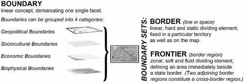
The term “boundary” emerged in the seventeenth century and is derived from bound [a limit] as well as from bonnarium [a piece of land with fixed limits]. A “boundary” is a linear concept, demarcating one particular facet (e.g. religious community) (Haselsberger, Citation2010). Natural boundaries follow natural features, such as rivers, mountains or coastlines (Cukwarah, Citation1967; Konrad & Nicol, Citation2008). “Artificial” boundaries are established by social or political agents or agencies to distinguish between national, ethnic, religious, linguistic, legal or security differences (Haughton, Citation2009) and cut across natural landscapes. Anderson and O'Dowd (Citation1999) suggest that in anthropology and sociology, sociocultural boundaries are typically deemed to be imprecise or indeterminate and are frequently contested. Konrad and Nicol (Citation2008) highlight that political boundaries are in most cases superimposed on the territory.
The term “frontier” emerged in the fourteenth century and was used to define “the neutral zone” between empires or states and took the shape of a relatively “empty” territory with few or no human settlements (Haselsberger, Citation2010; Konrad & Nicol, Citation2008). Over the years this neutral and empty zones transformed into populated marchlands (also marklands), which were governed by a margrave, whose purpose was to defend the empire or state against attacks from outside. In some cases the important role of the mark was even acknowledged in the name of the province or state adjacent to the border, e.g. Mark Brandenburg, Denmark, Ostmark. Nowadays, the term “border region” is more frequently used to define an area immediately alongside a state's external border, or straddling it (Newman, Citation2003). Two adjoining border regions thus constitute a “cross-border region”. As Anderson and O'Dowd (Citation1999) highlight, cross-border regions may have an underlying cultural unity that is not congruent with state borders, e.g. the Basque countries of France and Spain.
2.3. Normative border concept: “thick” and “thin” borders
A world without borders and boundaries is a utopia. Unbounded functional activities, be they social, cultural or economic, would be formless. And no territory could be administered unless it was clearly demarcated. In short, we live in a world full of compartments that enable us to manage our lives collectively. How could we acquire a national identity if we were not able to distinguish between “us” and “them”? How could we draw up a plan or “develop” a given territory unless the appropriate region was defined beforehand? Thus, borders are essential to our everyday life and attempting to eradicate them is a meaningless project. But not all borders are perfect fits. This article argues that the thicker a border is, meaning the more boundaries it consists of and the more functions imposed upon it over the years, the more difficult it is to cross, both physically and mentally. Furthermore, borders that divide what should belong together are in most cases perceived as uncomfortable and oppressive, disturbing lines by the borderlanders. Classifying borders into “thick” and “thin” borders implies looking at their formative influences and impacts on the development of the adjacent border region(s) as well as the way they continue to impede the conditions of the people living in these areas.
“Thick” borders are extremely rigid. They are characterised by disrupting relational geographies which belong together and which, as a consequence, can easily become a breeding ground for political disputes. This includes, for example, situations where there is a lack of congruence between a border and other types of boundaries, or where a border fails to coincide with the boundaries of nation, culture or ethnicity, as can be observed in the case of the Kurds in Turkey, Iraq and Syria or the Basques and Catalans in Spain. A good example of a “thick” border is the “Iron Curtain”, which was a difficult-to-cross border, inhibiting interactions with neighbouring states. The result was that border regions along the “Iron Curtain” were – and still are in some parts – economically disadvantaged and have experienced significant volumes of out-commuting or, at its most extreme, outmigration, reducing these areas' vitality. The “Iron Curtain” is probably the most extreme example in Europe; however, similar developments can also be observed along other borders throughout the world (e.g. the closed border between the two Koreas or the border between Mexico and the USA). Other quite representative examples, where “thick” borders can be detected, are “divided cities”, such as Berlin (Germany), Nicosia (Cyprus) or Gorizia (Italy).
“Thin” borders are permeable for certain kinds of flows. This does not mean that a border should be open for everything and everyone, as this would make the border itself redundant. On the contrary, while a “thin” border clearly demarcates a political and administrative space, at the same time it allows different forms of coexistence to emerge and flourish irrespective of the underlying state border. The border between the Innviertel (Austria) and Niederbayern (Germany) serves as a good example of a “thin” border. Though the Innviertel belonged to Germany until 1779 and a natural difficult-to-cross barrier – the River Inn – makes up the border, this cross-border region represents itself as a lively hub of cross-border interactions between people and institutions. The establishment of the European Nature Reserve “Lower Inn” in 1979, which is now also protected under the Ramsar convention on Wetlands, certainly favoured the exchange in this cross-border region. Equally, the border city of Braunau (Austria) and the border city of Simbach (Germany) are currently looking for a cross-border city manager. The main task of this person will be to coordinate trade development in both cities with the aim of establishing a competitive twin city. This example shows that both border regions have refrained from aligning further functions to the existing state border. On the contrary, the focus lies in making the underlying state border more permeable and in doing so allowing different kinds of soft spaces to emerge.
Unfortunately, Europe is currently comprised of more “thick” than “thin” borders, which results from the border drawing practices in the aftermath of the two World Wars. While it appears obvious that the external border of the European Union is a “thick” border, it has to be highlighted that also many internal borders of the European Union are not perfect matches. This issue has already been acknowledged by the European Commission, which has declared that the “frontier … is the place where the success of the European integration will be proven” (Corvers, Citation2001, p. 372). So it is not a surprise that the European Commission places much emphasis on softening borders as well as solving border-related problems, by enabling and promoting different forms of cooperation beyond borders. As discussed in this article, there is great value in re-establishing those relational geographies which have been disrupted in a former bordering process, for instance, in the case of “divided cities”. But such a move is not as easy as it might seem. After a long period of living in a divided city, differences may have congealed to an extent and relational geography may be difficult to achieve.
Going beyond definitions, it is important to recognise borders as socially constituent power practices, which give a demarcation in space its meaning and by doing so represent “time written in space” (Popescu, Citation2012; Van Houtum, Citation2011). Also, borders have both material and symbolic appearances and meanings. They can have a very obvious physical presence (e.g. the “Iron Curtain”) and/or a visually indistinct one, which becomes reality through, for example, stereotyping of the “others” behind the border. In order to understand the relationships between borders and boundaries (the product) and bordering (the process) the next section introduces a dynamic border interpretation framework. This framework helps planners to uncover the different planning challenges resulting from borders and boundaries as well as from bordering processes.
3. Decoding borders step 1: from borders to bordering practices
Borders should not be taken for granted, as if they were elements with one essence, function and trajectory. Neither should borders be understood as having some universal, independent causal power. Instead they are social and political constructs that are established by human beings for human – and clearly at times for very non-human – purposes. (Paasi, Citation2005, p. 27)
3.1. Towards a dynamic border interpretation framework
The approach developed in this section seeks to create a fundamental basis in understanding how the different functions and components of boundaries work together to constantly create and diminish borders. The interdisciplinary border model outlined by Brunet-Jailly (Citation2004) serves as a good starting point. Brunet-Jailly identifies four fundamental variables – market forces, multiple and integrated government action, culture, and popular control – through which the characteristics of borders and border regions can be grasped. However, in contrast to Brunet-Jailly's model, this article suggests that all functional variables and components of the bordering processes require equal treatment. It is argued that this is crucial in unpacking the power relations behind the bordering processes: “who benefits from the maintenance and institutionalization of the bordering process and, conversely, who benefits from the removal and opening of borders?” (Newman, Citation2003, p. 22)
Table is the outcome of an extensive border literature desk-research. It seeks to combine traditional border discourse with those being discussed by a cross-disciplinary audience of scholars in a neutral way. This border literature has emerged in several different disciplines, but not in planning. The “dynamic border interpretation framework” presented has not been elaborated for the purpose of being applied in its entire complexity to any case study. On the contrary, it seeks to summarise the potential border attributes, as currently discussed by border scholars, in its entirety. But what is the added value of the “dynamic border interpretation framework” for planners? First, it provides a means for planners to understand that it is not sufficient to acknowledge only the physical demarcation functions of borders, but their entire complexity. Second, planners are generalists, and planning is inter-disciplinary. Building on the knowledge provided from other disciplines helps to properly understand emerging planning challenges. Third, every border is unique and has its own history and trajectory. With the help of Table , planners can and should identify those variables which are at play in the concrete border region under consideration. It assists in unravelling the different layers (including their dynamics) which constitute a “thick” border.
Table 1 Dynamic border interpretation framework.
In this first step towards the decoding of borders, the different border and bordering components are disaggregated from each other. It is argued that the neutral listing of border functions and bordering power relations according to the different boundary categories ensures that, for example, geopolitical discourses that create or confirm access in and out of particular territories are not privileged over sociocultural discourses defining and transmitting cultural codices. It could be argued that unpacking the complex border concept by repacking boundaries into categories and examining their relationships is to some extent a conflicting approach, as each boundary category represents a great variety of different boundaries as well (e.g. the sociocultural boundary category subsumes religious boundaries, ethnic boundaries, language boundaries). However, this approach also has an advantage: the different boundary categories provide a means to determine border-related planning challenges.
3.2. Border-related planning challenges
Planners tend to consider merely the physical demarcation function of borders in the frame of their daily work. This is not sufficient. Planners need to acknowledge the entire border complexity by making use of the intrinsic knowledge base provided by border scholars. The following discussion of a few examples demonstrates what happens when (contradictory) functions of different boundary categories coincide and explains why this is relevant to planners.
The geopolitical–sociocultural boundary relationship: State borders are central to both the organisation of a political community (geopolitical function) and the protection of group interests (sociocultural function) and they therefore order both space and people (Scott, Citation2012; Van Houtum, Citation2011). In practice this means that various framings and discourses from sociocultural bordering practices are applied to geopolitical boundary lines. But identity is a voluntary process and people identify themselves with collective institutions only if they feel that they will also benefit, for example by gaining security or material welfare (Paasi, Citation2005). Every state aims to persuade people to participate in this exchange, by both highlighting the benefits of sharing a national identity and creating distance from the world outside (e.g. through stereotyping). Emerging planning challenges: Geopolitical boundaries define the different compartments within which we live in a hierarchical way. Planners elaborate development concepts, strategies and plans for these supra-national, national, sub-national, regional, and local territories. In doing this the geopolitical boundaries are taken for granted and what lies behind this “border of comfort” (as Van Houtum, Citation2003, calls it) is often not questioned. But while pre-defined departments facilitate the work of planners, planners must equally be aware of the “invisible” sociocultural boundaries that exist in both macro and micro spaces. In this regard it is important to underline that planning decisions aim at, and affect, both the physical and sociocultural geography at various scales ranging from the local to the supra-national level. Therefore planning processes need to unfold within the differing contexts of the countries' legal structure(s), planning system(s), planning law(s) and regulation(s) while also allowing new forms of governance involving a broad spectrum of stakeholders. This is particularly relevant for those planners working on participatory plan development and implementation, as well as those examining innovative ways of mobilising, involving and empowering stakeholders in decision-making processes.
The geopolitical–economic boundary relationship: Some of the functions of geopolitical boundaries – in particular in relation to industry and economic development – have been significantly reduced since the 1970s, due to globalisation processes (Anderson & O'Dowd, Citation1999). Thus globalisation has challenged the protective function of geopolitical boundaries as they relate to security concerns, as Haughton (Citation2009) points out when considering the US–Caribbean border. While US Homeland Security – an important border control agency in the USA – must prevent illegal entry to the USA, it also needs to ease restrictions in order to facilitate the global movement of resources and products across the border. Chalfin (Citation2012) says that “border security is as much economic as political in orientation, fundamentally shaped by material processes and logics” (p. 284). Problems and contradictions arise when cross-border facilitation (e.g. for economic reasons, such as flow of commerce, labour or capital) and prevention and security concerns clash. Emerging planning challenges: Globalisation has impacted upon state borders in the sense that they have become more porous for certain kind of flows than in the past. This has a two-fold effect on planning. Firstly, in a transnational “visible” way, when the space under consideration is a cross-border region, and secondly in an international “invisible” way, when the states concerned do not straddle the same geopolitical boundary. In the first case, the cross-border business and trade parks require not only on-site development plans but also spatial linking and embedding (social and technical infrastructure, such as traffic, housing, research and development providers) within the two respective national systems. In the latter case there is a growing tendency for companies to set up business sites in countries other than their home nation. The past has shown that foreign investors evaluate potential sites based on hard factors (e.g. transport connection, space availability, employment market, energy supply, local and national taxes), soft business-related factors (e.g. local and regional image and business climate, professional networks and cooperation partners, research and development, innovative milieu of the region) and soft personal aspects (e.g. quality of life and environment, education and leisure opportunities). This offers new development perspectives, in particular for regions which are well-connected within the country itself but also cross-nationally as investors often decide against capital city locations.
The geopolitical–biophysical boundary relationship: In contrast to any other boundary function, biophysical boundary functions cannot be aligned to a geopolitical boundary. Some geopolitical boundaries encompass natural features, such as major rivers (e.g. the Rio Grande between Mexico and the USA) or mountain ranges (e.g. the vast Karakoram mountain range in the Himalayas between Pakistan, India and China). As biophysical boundaries take the form of zones rather than lines, one has to be aware that “without exception, all geopolitical boundaries cut across land-based and marine habitats” (Cunningham, Citation2012, p. 375). Any geopolitical bordering intervention can lead to severe “ripple effects” such as water shortage or biodiversity loss. For example, the secure border between the USA and Mexico (security and protection function) affects endangered animals such as the ocelot or the jaguar, which require wide open spaces to survive and maintain their gene pool diversity. Emerging planning challenges: The relationship between environment, renewable and non-renewable resources, climate change and extreme weather events on the one hand and the vulnerability of community systems on the other poses many challenges to planners. Strengthening urban and regional resilience is a potential way for planners to address future threats resulting from ecosystem biodiversity losses, which have already taken place and which cannot be assessed precisely. This includes issues such as securing arable land for food production and protecting natural areas to mitigate the outcomes of extreme weather events such as high flood damage. Planners are advised to think in terms of environmental geographies, for example, when they develop high flood protection or management plans, and should avoid not taking into account things which are taking place on the other side of a geopolitical boundary. Biophysical impacts have their own logic and do not follow artificial, human made boundaries.
The sociocultural–economic boundary relationship: No economy can operate “without social relations and cultural coding, and combined and uneven relations exist as much at the level of border culture as border economics” (Heyman, Citation2012, p. 59). Though many economic activities are entirely bounded by the national territory, Heyman reminds us not to forget that some border cities (e.g. along the US–Mexican border) benefit from economic transactions that cross borders. For example wealthy Mexicans like to shelter capital in the USA, buying consumer goods such as vehicles or consumer electronics and purchasing real estate for investment. In addition, many people cross the international border daily for employment reasons. These processes give rise to both “hybrids (e.g. Spanglish) and polarisation (e.g. linguistic tensions between bilingual Mexican-Americans and monolingual Mexican immigrants)” (Heyman, Citation2012, p. 58). Emerging planning challenges: The recent recession has changed our understanding of economic growth and development in both the public and private sectors. The global slow-down in productivity and the related increase in unemployment highlight the social impact of the economic crisis. Due to this changing economic climate, the topic of urban and regional prosperity under austerity has gained attention within the planning community. Planners are now challenged to think about new methodological tools which are able to address the current economic and social dynamics. This also includes the question of how dependent urban and local places are on the outside regions, in terms of resources, people and land. Further new urban and regional economic policies which relate to international or national frameworks (such as the EU or the World Bank) are required.
The sociocultural–biophysical boundary relationship: Natural landmarks such as mountains can have a very strong symbolic meaning, particularly where social groups recognise them as the anchor of their identity. Mount Ararat, the highest mountain in Turkey, which was located in Armenia until the Armenian Genocide in 1915, represents such an anchor point for the Armenian population. Even now it is the national symbol of the Republic of Armenia and represented on their currency. The problem in this concrete case is that whenever Armenian people see Mount Ararat (in reality or on their currency) the memory that Mount Ararat belonged to Armenia, and those of the “horrors of the Armenian Genocide in 1915” are reproduced, and this affects the relationship with Turkey (Egoyan, Citation2002). Emerging planning challenges: Culture and natural heritage play an essential role in spatial planning and in particular place-making. On the one side, growing globalisation calls for strengthening local and regional identity, and planners are exploring different features capable of fostering local and regional identities. On the other side, as the territorial capital of a region has become a starting point for strategic spatial planning, planners have started to develop strategies to benefit from cultural and natural heritage as a significant territorial potential for spatial development. But the relational geographies of culture and natural heritage do not always overlap, as explained above. Therefore, planners are challenged to work on the right balance between protection, historicising past events, and the promotion of future-oriented urban and regional environments. Central to this are questions relating to the pros and cons of the changing roles attributed to culture and natural heritage and whether promoting culture and natural heritage as drivers of development inevitably leads to gentrification effects.
The economic–biophysical boundary relationship: Increased economic activity (brought about by globalisation) may result in increased environmental degradation as Cunningham (Citation2012) has explained using the example of the Gulf oil spill caused by BP in April 2010. The explosion and sinking of the Deepwater Horizon oil rig immediately affected Louisiana and Florida, but as the slick entered the Loop Current and then the Gulf Stream it also seriously threatened other coastal areas in Cuba, the Yucatan Peninsula of Mexico and the Atlantic Seaboard of the USA (Cunningham, Citation2012). This example shows that economically created environmental problems in one country can have an impact on the environment of several different countries. Emerging planning challenges: Economic activities exert influence on quality of life and places. Awareness of natural disasters caused by economic activities has increased, and as a result more and more mitigation strategies are being developed and implemented. Whilst in theory the precautionary principle should have guided environmental planning transnationally, in practice, to date, environmental pressures and problems resulting from economic activities have tended to precede remedial actions. Examples include oil production, CO2-emissions, loss of natural habitats and biodiversity, and global climate change. Probably the most crucial question is how we achieve more pro-active environmental planning and how to avoid environmental problems or natural disasters before they arise. Notwithstanding these efforts, we have to be aware that not everything can be stopped instantly. Therefore adaptation strategies need to focus on anticipating the environmental impacts of economic activities in three respects: monitoring potential damages (risks), coping with the consequences, and taking advantage of strategic environmental assessment and environmental impact assessment regulations and tools.
4. Decoding borders step 2: from bordering practices to relational geographies
The border acts as a unifying instrument for a nation, for building up a “national self-portrait” – in active and passive form: The border makes and is made. (Van Houtum, Citation2011, p. 51)
4.1. Border-related relational geographies
It has been explained that not every border needs to be open or closed for everything and everyone. Therefore, in addition to the well-studied geopolitical “container” effect of borders (Agnew, Citation2003; Diener & Hagen, Citation2012), this section advises planners to also unravel all of the spatial dynamics derived from the various functional and environmental relational geographies at play. Allmendinger and Haughton (Citation2009) say that “whilst planning still needs its clear legal ‘fix’ around set boundaries for formal plans [geopolitical boundaries], if it is to reflect the more complex relational world of associational relationships which stretch across a range of geographies, planning also needs to operate through other spaces [e.g. functional spaces]” (p. 619). Table provides an overview of which boundaries define which types of spaces. As all these different spaces are meant to coexist, the message of this article is not that planners and border scholars should privilege one space over the other, but rather acknowledge that multiple spaces exist in parallel.
Table 2 Relational geographies according to border categories.
Functional spaces have their own logic and do not automatically coincide with political and administrative or environmental spaces (Davy, Citation2002). If the political and administrative space differs from any functional space, the following situation is most likely to emerge. The functional boundary is aligned to the geopolitical boundary by power elites. As the Austrian case below demonstrates, in the past and to a lesser extent even today, power elites have tended to control and manage the bordering process by making use of the “framings and discourses” as well as the “perceptions and interpretations” from the different boundary categories for their own purposes. The result was that as many functions as needed became aligned to one concrete line in the territory. The border became thicker and thicker. This was – and still is – possible, as all boundaries apart from the biophysical ones are ambiguous human constructions, produced, reproduced and justified through social practices and discourses. But this alignment process is inherently contradictory, problematic and multifaceted. In the majority of cases state borders have not emerged as an evolutionary historical inevitability or in the frame of a democratic process. On the contrary, most of them are imposed on the world's surface through violence, force and intimidation in the course of wars, conquests and state formation (Paasi, Citation2005; Tilly, Citation1990).
4.2. The case of Austria (Europe)
The borders of Austria (in its current shape) were not fixed before 1955, making it a fascinating case for analysis of the concrete border-drawing exercise. As an example it addresses in particular the question of how and why it was possible for the spatial dimensions of different functional spaces to be made identical with the geopolitical and administrative spaces of a nation. By doing so, a compartment – the republic of Austria – became reality, not only on the map but also in the minds of people. Understanding the underlying dynamics which made the Austrian border thicker and thicker provides valuable insights for grasping the many different layers this border is comprised of today. The case study description takes the end of the Austro-Hungarian Empire as a starting point and explains from there the emergence of the Austrian state border. Afterwards it analyses the bordering master stroke undertaken by the Austrian politicians in the example of symbolic and educational unifiers. Finally, it discusses what role the container effect of the Austrian state border plays nowadays in the frame of cross-border cooperation endeavours and how it hampers them in the example of the “thick” border between Austria and Slovakia.
4.2.1 The emergence of the Austrian state border
The First World War (1914–1918) ended the Austro-Hungarian Empire and in doing so marked the end of the three-century long Habsburg dynasty in Austria. The newly created state called “Republik Deutschösterreich” (Republic of German Austria) was only 17% of the size of the Austro-Hungarian Empire, had 20% of its population, and its borders were regulated by the peace treaty of Saint-Germain-en-Laye (Schausberger, Citation2008). The result was a feeling of homelessness amongst the Austrian population, and even Austrian politicians did not believe that the “small” republic had any chance of survival (Kriechbaumer, Citation2001). At the constituent national assembly in 1918 politicians proclaimed, “Gott behüte uns alle, dass wir Österreicher werden” [May God protect us that we all become Austrians] (Kluge, Citation1984, p. 18). In 1933 Hitler came to power in Germany and in 1938 Germany invaded Austria. The result was that Austria became part of Germany and, until the end of World War II, it disappeared altogether from the political map of Europe (Stelzl-Marx, Citation2005). After the end of World War II, Austria was re-established as the independent “Republik Österreich” (Republic of Austria) (Steiner, Citation2005). But, due to the Allied occupation between 1945 and 1955, Austria was far from being a united independent state. During this period Austria was divided into four occupation zones (British, American, Russian and French), as was the capital, Vienna. Each single occupation zone was clearly demarcated, and access in and out of each zone was controlled by the military. Passing a zone border was only allowed with a valid travel permit (Stelzl-Marx, Citation2005). In 1955, the annus mirabilis, the Austrian solution was agreed. Firstly, the Austrian State Treaty was signed by the Allies, defining Austria as a sovereign, independent and democratic state by re-establishing its January 1938 borders (May 15th). Secondly, Austria declared its perpetual neutrality, and as a consequence the occupation troops left Austria (October 26th). Thirdly, Austria became a member of the United Nations (December 14th) and then a member of the Council of Europe in 1956 (Cede, Citation2005; Rezac, Citation2005). Since that time the geographical borders of Austria have not changed.
4.2.2 The Austrian bordering master stroke
It is often argued that the end of the Austro-Hungarian Empire (1918), which from an Austrian perspective is characterised by the loss of Austria's “great power” position within Europe, its reduction to a small state, the concision of economic resources together with the difficulties in establishing an Austrian republic, hindered Austria in building a national identity (Kriechbaumer, Citation2001; Ulram & Tributsch, Citation2008). The name of the first republic – “Republic of German Austria” – mirrors these difficulties and also illustrates the “self-portrait” of the Austrian population, who at that time considered themselves to be Germans, but with a strong loyalty to the Habsburg dynasty (Kriechbaumer, Citation2001). This strained situation lasted till the signing of the Austrian State Treaty in 1955 and was heavily afflicted by conflicts. For example in 1945 Leopold Figl (at that time chancellor of Austria) appealed to the Austrian population not to identify themselves as a second German state, a branch of another nationality, but to consider themselves as Austrians with loyalty and passion.
Wenn wir immer wieder mit allem Fanatismus heimatverwurzelter Treue betonen, daß wir kein zweiter deutscher Staat sind, daß wir kein Ableger einer anderen Nationalität jemals waren noch werden wollen, sondern daß wir nichts sind als Österreicher, dies aber aus ganzem Herzen und mit jener Leidenschaft, die jedem Bekenntnis zur Nation innewohnen muß, dann ist dies keine Erfindung von uns, die wir heute die Verantwortung für diesen Staat tragen, sondern tiefste Erkenntnis aller Menschen, wo immer sie stehen mögen in Österreich. (Figl, Citation1965, pp. 59, 60)
[We must continue to emphasise, with a fanaticism rooted in patriotic loyalty, that we are not a second German state that we have never been nor will be a branch of another nationality, but that we are wholeheartedly Austrians. With this passion, that is inherent in every commitment to a nation, this is not an invention of us who bear the responsibility for this state today, but a deep understanding of all people, wherever they may be in Austria.] (translated by Beatrix Haselsberger)
Die Österreicher sind eine verweichlichte, weibische Rasse, drauf und dran, dass ihnen Gewalt angetan wird. Das letzte Mal waren es die Deutschen. Nächstes Mal sind es vielleicht die Russen. Sie sind nicht nur verweichlicht, sondern sind in vielerlei Hinsicht orientalisch in ihrer Schicksalsergebenheit und Bereitschaft zu akzeptieren, was sie als unwiderstehliche Kraft spüren. (Bischof & Leidenfrost, Citation1988, p. 14)
[The Austrians are a mollycoddled race and as a result they suffer through violence. The last time it was the Germans. Next time it might be the Russians. They are not only mollycoddled, but are in many ways “oriental” in the way they accept their fate if perceived as a fatal force.] (translated by Beatrix Haselsberger)
(1) Symbolic unifiers of Austria or activities undertaken by political elites:
The Austrian anthem: In 1945 there was a big discussion about whether the old Austro-Hungarian anthem – the Haydn melody – could be used as the new anthem for the Republic of Austria. The main problem was that in 1938 the “Deutsche Reich” (the Third Reich) adopted this Haydn melody as its anthem, though with different lyrics. In 1946 the Bundeslied (song of the nation) by MozartFootnote2 became the new Austrian anthem melody. The anthem lyrics, by Paula von Preradović, were added in 1947 (Kriechbaumer, Citation2001; Stelzl-Marx, Citation2005).
The Austrian flag: The colours of the Austrian flag (red-white-red) and the integrated symbol of the Austrian flag (the eagle) have their origins in the Austro-Hungarian monarchy (Kriechbaumer, Citation2001). Interestingly this flag was already used as a unifying symbol in the first republic (the Republic of German Austria). In the second republic (the Republic of Austria), however, it was strategically promoted as different from the German flag (black-red-yellow), in memory of the “glorious” Austro-Hungarian history (Busek, Citation1998).
The Austrian State Treaty: Over the years the Austrian State Treaty became a meaningful symbol of the free and independent Austria. In 1955, when Leopold Figl symbolically displayed the signed Austrian State Treaty on the balcony of the Belvedere palace with the words “Österreich ist frei” [Austria is free], a meaningful photo was taken (Busek, Citation1998). This picture became an essential element of the cultural memory of Austria, which is still transmitted via school books, media, etc. (Kriechbaumer, Citation2001).
The Austrian national holiday: In 1965 the National Assembly of Austria declared October 26th to be the first Austrian national holiday. This day was selected because the last soldier of the occupation forces left Austria on 26 October 1955 (Kriechbaumer, Citation2001). This national holiday became a symbol of the free Austria and even today it is an officially approved day off.
(2) Educational unifiers of Austria or activities undertaken by political elites:
School curricula: It was considered highly important to end the intellectual and cultural dependency on Germany as well as to eliminate racist and anti-Semitic thoughts via educational initiatives (Bruckmüller, Citation1998). Since 1945 the history of the Habsburg dynasty, the achievements of Austrian artists and scientists, Austrian local and regional traditions, etc. have been taught in schools. In addition pupils are taken on excursions to Austrian monuments and Austrian enterprises (Stelzl-Marx, Citation2005). The name of the school subject “German language” was changed to “language of instructions” (Brix, Citation1998).
Musical tradition: Building on the musical tradition of the Habsburgs as well as Austro-Hungarian Empire, the Vienna Philharmonic Orchestra and the Salzburg Festival were enabled to carry on their work immediately after World War II. The State Opera House and the Burg Theatre were also ceremonially re-opened in 1955 (Stelzl-Marx, Citation2005). It is also assumed that choosing a melody by Mozart for the new Austrian anthem was not a coincidence.
Collective remembering: The “Opferthese” [victim assumption], having its origins in the 1943 Moscow Declaration, quickly unified the Austrian population after World War II (Sandgruber, Citation2003). But although being a “collective victim of the war” provided a means to overcome the horrors of World War II, it also led to a partial repression of the years 1938–1945 and a superficial coming to terms with the past (Hanisch, Citation2005). It was not until Kurt Waldheim's presidential candidacy in 1986 that the victim assumption of Austria was debated officially. Part of this debate was the accusation that Austria was not the first victim of the war, but was actively involved in the National Socialist crimes of World War II (Hanisch, Citation2005). However, though these accusations (coming in particular from the USA) were true to some extent, the Waldheim affair unified the Austrian population, this time under the umbrella of “being a victim of US accusations”.
After 1955 the Austrian population slowly started to identify themselves with the “new” state as well as with its political system (Brix, Citation1998; Stelzl-Marx, Citation2005; Ulram & Tributsch, Citation2008). While in 1956 less than 50% of the Austrian population considered themselves Austrian, this percentage increased to 64% in the 1970s, 74% in the 1980s, 78% in the 1990s and 82% in 2007 (Ulram & Tributsch, Citation2008, p. 47). Bruckmüller (Citation1998) argues that from the early 1970s the Austrian consciousness, in the sense of a collective feeling of togetherness, was strong enough to build the basis for a proper Austrian identity. But, as highlighted above, this mind-changing process did not happen by coincidence; it was guided and accompanied by salient events and documents which have still not lost their importance for the Austrian identity.
When looking at the Austrian bordering master stroke from a planning perspective, two issues arise. On the one hand, the achievement of a stable national identity facilitates the work of planners within Austria in terms of mobilising, involving and empowering stakeholders in decision-making processes regarding formal plan making. On the other hand, any boundary alignment process makes the respective state border “thicker”, more complex, and enforces the container effect. This in turn poses several challenges to cross-border planning endeavours aiming to make the state border more permeable.
4.3 The container effect of the Austrian state border
This article has demonstrated that borders are boundary sets and that every border is unique, with its own history. In the case of Austria, different boundaries were aligned to a single “line”, which was imposed on the world's surface in 1955 and was meant to define the national territory. But in drawing this line, many relational geographies were simultaneously disrupted and new differences between one side of the line and the other subsequently evolved, initiated to some extent with the help of symbolic and educational unifiers. What happened afterwards and what is often underestimated is that this newly established collectivism got transmitted from one generation to the next via time-independent preservative symbolic artefacts (e.g. anthem, flag, state treaties, national holidays) and operational educational practices (e.g. school curricula, musical tradition, collective remembering). As a result, the newly created differences became essential points of reference for the subsequent generations. This makes it more difficult, sometimes even impossible and inadequate, to re-establish formerly relational geographies. As Newman says (Citation2003), it is naïve to think that border-opening processes will automatically remove all barrier functions of the border that allowed differences to appear in the aftermath of the border-drawing exercise. Thus, overcoming the container effect of state borders through various forms of cross-border cooperation is a very challenging and sensible task that requires much more than “just” addressing the geopolitical dividing function of the state border under consideration. It requires the detection of relational geographies which are disrupted by this state border, and moreover, the working out of appropriate solutions to reunite them, where this is still possible. This includes, among other things, the coordination of differing or even conflicting interests and intentions on both sides of the border.
The example of the Austrian-Slovakian cross-border region helps to explain this argument. This particular territory builds on a long shared history (1526–1918), which, however, is currently largely academic rather than an active cultural variable. The completely separate development triggered in particular by the “Iron Curtain” created many boundaries, not only physically but also mentally and emotionally. `Even though the “Iron Curtain” was removed in 1989, some of the sociocultural boundaries still exist today. They become evident in terms of mutual antipathy and distrust, which hinder effective forms of contemporary cooperation. This has been experienced by the author in the frame of an INTERREG IIIA project along the Austrian-Slovakian border in 2005–2006. The aim of the project was to draft a cross-border master plan for the Austrian-Slovakian cross-border region. In this example, the visions for the undeveloped land of the former “Iron Curtain” were driven by two conflicting interests. On the one hand the pro-development coalition in Bratislava (Slovakia) was aiming to develop exclusive upmarket real estate in an area of natural beauty. On the other hand, the landscape preservation coalition in Austria was keen on contributing to the ecological network initiative of the “European Green Belt” that runs from the Barents to the Black Sea (following the path of the former “Iron Curtain”). Moreover, the actors involved immediately found it easy to agree on what should happen “over the border” for their own benefit, with Slovakian actors keen to benefit from the recreation and landscape potential of the Austrian territory and Austrian actors with many ideas for the unspoilt territories of the former “Eastern Bloc lands” on both sides of the state border (Haselsberger & Benneworth, Citation2011). This project failed in drafting an effective cross-border master plan, simply because it ignored the underlying border complexity. It did not offer appropriate solutions for overcoming the sociocultural boundaries; rather, it focused merely on the geopolitical dimension of the border. The lesson learnt is that the social affiliation to each group's own country (on both sides of the border) was much stronger and more developed than the desire for cooperation with any other country. Because of this, each group's own interests (irrespective of the other group's interest) were favoured at every stage of the project.
5. Conclusions
At the dawn of the twenty-first century we live divided along cultural, economic, political, and social lines, in a world of territorial borders whose main purpose is to mark differences in space. (Popescu, Citation2012, p. 1)
The main objective of the recent border opening processes (e.g. within the European Union) was to make borders more permeable for different kinds of flow (e.g. the free movement of people, goods, services and capital) by addressing the geopolitical layer of the border. But borders are boundary sets, and thus composed of a number of different layers. Thus, to make a given border more permeable for selected geopolitical types of flow is only a first, though essential, step towards overcoming negative border effects as the Austrian-Slovakian example has emphasised. No border, however, can be open for everything and everyone, as this would make the border itself redundant. I therefore argue that as a second step towards overcoming negative border effects it is necessary to identify those relational geographies which are currently being disrupted, and thus could easily become a breeding ground for political disputes. In addition, new relational geographies should be established according to the contemporary needs of the borderlanders from both sides of the border.
The argument here is not that planning professionals “who use their managerial skills to undertake the process of delimitation and border implementation” (Newman, Citation2003, p. 22) should focus on creating new “thick” borders. Planners have to be aware that when they set up a cross-border region (e.g. a Euroregion) or re-unite a relational geography, they both diminish the importance of the state border, and also create a new boundary demarcating this new region. The main function of this new boundary creating a cross-border region should be primarily administrative and political. Rather than aligning other functions to this new line, its main objective would be to make the underlying border more permeable and by doing so allow different kinds of soft spaces to emerge. All of these different relational geographies need to exist in parallel and assist that in the long term boundary after boundary is removed from the state border under consideration.
Shifting the perspective from borders to relational geographies goes hand in hand with breaking away from the shackles of pre-existing “container thinking”. Yet it is difficult to do this, because these two perspectives – container and relational thinking – are in fact interrelated. Whereas a certain degree of “container-thinking” is required when addressing issues of sovereignty, other issues such as identity or ethnicity demand “relational thinking”. The challenge is thus to think and work within multiple hard, soft and fuzzy spaces in parallel. The territorial expansion of these different spaces is not identical. Therefore each of these spaces not only transcends the border, but many other geopolitical, sociocultural, economic and biophysical boundaries too. This perspective may make it possible to overcome negative border effects by transforming “thick borders” into “thin borders” and consequently expanding the horizon to an intertwined network of spaces.
Acknowledgements
The author wishes to thank three critical friends – John Friedmann (University of British Columbia), Benjamin Davy (Technische Universität Dortmund) and Victor Konrad (Carleton University, Ottawa) – and four anonymous reviewers for their thorough and helpful comments.
Additional information
Funding
Notes on contributors
Beatrix Haselsberger
Beatrix Haselsberger is a Senior Researcher at the Department of Spatial Planning of the Vienna University of Technology (Austria). In 2012, she was awarded the prestigious Hertha Firnberg Research Grant from the Austrian Science Fund for the project COMPASS (Collective Memory & Planning: Across Social Separation), Project Number: T591-G16. As part of this project, Beatrix Haselsberger (together with her co-editor Laura Saija, University of Catania, Italy) is currently editing a book about The Evolution of Planning Thought, which will be published in 2015. http://info.tuwien.ac.at/planning-thought
Notes
1. It needs to be acknowledged that enclaves are by no means only a historical phenomenon. On the contrary, some of them are still extant today (Campione, Italy or Kaliningrad, Russia) and others have been created more recently (e.g. De Voerstreek in Belgium). Today's most curious European enclaves/exclaves situation might be discovered along the Dutch-Belgian border in Baarle-Hertog/Baarle-Nassau (a city of around 10,000 inhabitants) which could even be regarded as “Europe's most complicated border configuration” (Gardner & Kries, Citation2005, p. 16). This city comprises on the one hand the Belgian Baarle-Hertog, which consists of 22 enclaves completely surrounded by the Dutch territory of Baarle-Nassau. On the other hand Baarle-Nassau has one Dutch enclave in Belgium and seven exclaves embodied in the Belgian enclaves. All together this city has 30 enclaves!
2. It is not entirely clear whether Wolfgang Amadeus Mozart is the composer of this melody (Stelzl-Marx, Citation2005, p. 217).
References
- Agnew, J. (2003). Geopolitics: Re-visioning the World politics (2nd ed.). London: Routledge.
- Allmendinger, P., & Haughton, G. (2009). Soft spaces, fuzzy boundaries, and metagovernance: The new spatial planning in the Thames Gateway. Environment and Planning A, 41, 617–633. 10.1068/a40208.
- Anderson, J., & O'Dowd, L. (1999). Borders, border regions and territoriality: Contradictory meanings, changing significance. Regional Studies, 33, 593–604. 10.1080/00343409950078648.
- Asch, R. G. (1997). The thirty years war: The Holy Roman Empire and Europe, 1618–48 (European history in perspective). New York, NY: Palgrave.
- Biggs, M. (1999). Putting the state on the map: Cartography, territory, and European state formation. Comparative Studies in Society and History, 41, 374–405. Retrieved from http://journals.cambridge.org/action/displayIssue?jid = CSS&volumeId = 41&seriesId = 0&issueId = 02.
- Bischof, G., & Leidenfrost, J. (1988). Die bevormundete Nation. Österreich und die Alliierten 1945–1955. Innsbruck: Innsbrucker Forschungen zur Zeitgeschichte.
- Brix, E. (1998). Widersprüche und wandlungen im Österreichbewußtsein der Zweiten Republik. In R.Kriechbaumer (Ed.), Österreichische Nationalgeschichte nach 1945. Die Spiegel der Erinnerung. Die Sicht von innen (pp. 449–467). Wien-Köln-Weimar: Böhlau Verlag.
- Bruckmüller, E. (1998). Die Entwicklung des Österreichbewußtseins. In R.Kriechbaumer (Ed.), Österreichische Nationalgeschichte nach 1945. Die Spiegel der Erinnerung. Die Sicht von innen (pp. 369–396). Wien-Köln-Weimar: Böhlau Verlag.
- Brunet-Jailly, E. (2004). Toward a model of border studies: What do we learn from the study of the Canadian-American border?Journal of Borderlands Studies, 19(1), 1–12. Retrieved from http://journals.uvic.ca/index.php/borderlands/article/view/1504.
- Busek, E. (1998). Was heißt Österreich? In R.Kriechbaumer (Ed.), Österreichische Nationalgeschichte nach 1945. Die Spiegel der Erinnerung. Die Sicht von innen (pp. 409–440). Wien-Köln-Weimar: Böhlau Verlag.
- Caplow, T. (1998). A model for the consolidation and partition of national states. International Review of Sociology, 8, 173–181. 10.1080/03906701.1998.9971269.
- Cede, F. (2005). Staatsvertrag und Neutralität aus heutiger Sicht. In M.Rauchensteiner & R.Kriechbaumer (Eds.), Die Gunst des Augenblicks. Neue Forschungen zu Staatsvertrag und Neutralität (pp. 519–536). Wien-Köln-Weimar: Böhlau Verlag.
- Chalfin, B. (2012). Border security as late-capitalist “fix”. In T. M.Wilson & H.Donnan (Eds.), A companion to border studies (pp. 283–300). Chichester: Wiley-Blackwell (Blackwell Companions to Anthropology).
- Corvers, F. (2001). European policies for European border regions: An active space approach. In M.van Geenhuizen, et al. (Eds.), Gaining advantage from open borders. An active space approach to regional development (pp. 369–387). Aldershot: Ashgate.
- Cukwarah, A. O. (1967). The settlement of boundary disputes in international law. Manchester: Manchester University Press.
- Cunningham, H. (2012). Permeabilities, ecology and geopolitical boundaries. In T. M.Wilson & H.Donnan (Eds.), A companion to border studies (pp. 371–386). Chichester: Wiley-Blackwell (Blackwell Companions to Anthropology).
- Davy, B. (2002). Wilde Grenzen. Die Städteregion Ruhr 2030 als Möglichkeitsraum. Informationen zur Raumentwicklung, 9, 527–537. Retrieved from http://www.bbsr.bund.de/BBSR/DE/Veroeffentlichungen/IzR/2002/Downloads/9_Davy.pdf?__blob = publicationFile&v = 2.
- Diener, A. C., & Hagen, J. (2012). Borders. A very short introduction. Oxfort and NewYork: Oxford University Press.
- Donnan, H., & Wilson, T. W. (1999). Borders: Frontiers of identity, nation and state. Oxford and New York: Berg.
- Egoyan, A. (2002). Ararat. Movie. Momentum Pictures World Cinema Collection.
- Figl, L. (1965). Reden für Österreich. Mit einer Einleitung von Ludwig Reichhold. Wien-Frankfurt-Zürich: Europa Verlag.
- Foucher, M. (1998). The geopolitics of European frontiers. In M.Anderson & E.Bort (Eds.), The frontiers of Europe (pp. 235–250). London: Continuum.
- Gardner, N. S., & Kries, S. (2005). Tangled territories. Hidden Europe, 3, 12–17. Retrieved from: http://www.hiddeneurope.co.uk/assets/files/hidden_europe_3_tangled_territories.pdf.
- Graham, M. W. (2006). News and frontier consciousness in the late Roman Empire. Ann Arbor: University of Michigan Press.
- Hanisch, E. (2005). Abschied von der Staatvertragsgeneration. In M.Rauchensteiner & R.Kriechbaumer (Eds.), Die Gunst des Augenblicks. Neue Forschungen zu Staatsvertrag und Neutralität (pp. 537–552). Wien-Köln-Weimar: Böhlau Verlag.
- Harley, J. B. (1989). Deconstructing the map. Cartographica: The International Journal for Geographic Information and Geovisualization, 26(2), 1–20. Retrieved from: http://www.unigis.at/fernstudien/UNIGIS_professional/Lehrgangs_CD_2/module/modul5/media/pdf/Deconstructing%20the%20map.pdf.
- Haselsberger, B. (2010). Reshaping Europe. Borders' impact on territorial cohesion. Vienna University of Technology: Unpublished Ph.D Thesis. Retrieved from: http://publik.tuwien.ac.at/files/PubDat_189885.pdf.
- Haselsberger, B., & Benneworth, P. (2011). Cross-border communities or cross-border proximity? Perspectives from the Austrian-Slovakian border region. In N.Adams, G.Cotella, & R.Nunes (Eds.), Territorial development, cohesion and spatial planning. Building on EU enlargement (pp. 229–254). London: Routledge.
- Haughton, S. A. (2009). The US-Caribbean border: An important security border in the 21st century. Journal of Borderlands Studies, 24(3), 1–20. Retrieved from: http://journals.uvic.ca/index.php/borderlands/article/view/533.
- Heyman, J. McC. (2012). Culture theory and the US-Mexico border. In T. M.Wilson & H.Donnan (Eds.), A companion to border studies (pp. 48–65). Chichester: Wiley-Blackwell (Blackwell Companions to Anthropology).
- Kluge, U. (1984). Der österreichische Ständestaat 1934–1938. Entstehung und Scheitern. Wien: Verlag für Geschichte und Politik.
- Konrad, V., & Nicol, H. (2008). Beyond walls: Re-inventing the Canada-United States borderlands. Aldershot: Ashgate.
- Krasner, S. D. (2001). Rethinking the sovereign state model. Review of International Studies, 27, 17–42. 10.1017/S0260210501008014.
- Kriechbaumer, R. (2001). Die großen Erzählungen der Politik. Politische Kultur und Parteien in Österreich von der Jahrhundertwende bis 1945. Wien-Köln-Weimar: Böhlau Verlag.
- Newman, D. (2003). On borders and power: A theoretical framework. Journal of Borderlands Studies, 18, 13–25. Retrieved from: http://journals.uvic.ca/index.php/borderlands/article/view/1529.
- Newman, D. (2006). The lines that continue to separate us: Borders in our ‘borderless’ world. Progress in Human Geography, 30, 143–161. 10.1191/0309132506ph599xx.
- O'Dowd, L. (2001). Analysing Europe's borders. IBRU Boundary and Security Bulletin, 2, 67–79. Retrieved from http://www.notabenenord.net/sites/default/files/event_files/ANALYSING%20EUROPE%E2%80%99S%20BORDERS.pdf.
- Paasi, A. (2005). The changing discourses on political boundaries. Mapping the backgrounds, contexts and contents. In H.van Houtum, O.Kramsch, & W.Zierhofer (Eds.), B/Ordering space (pp. 17–31). Farnham: Ashgate.
- Paasi, A. (2011). A border theory: An unattainable dream or a realistic aim for border scholars? In D.Wastl-Walter (Ed.), The Ashgate Research companion to border studies (pp. 11–32). Farnham: Ashgate.
- Popescu, G. (2012). Bordering and ordering the twenty-first century. Understanding borders. Plymouth: Rowman & Littlefield.
- Rezac, D. (2005). “Mechanik des Endes” – Finalisierung und Durchführung des österreichischen Staatsvertrages im Jahr 1955. In M.Rauchensteiner & R.Kriechbaumer (Eds.), Die Gunst des Augenblicks. Neue Forschungen zu Staatsvertrag und Neutralität (pp. 485–502). Wien-Köln-Weimar: Böhlau Verlag.
- Sack, R. (1986). Human territoriality, its theory and history. Cambridge: Cambridge University Press.
- Sandgruber, R. (2003). Das 20. Jahrhundert. Geschichte Österreichs. Wien: Pichler Verlag.
- Scott, J. W. (2012). European politics of borders, border symbolism and cross-border cooperation. In T. M.Wilson & H.Donnan (Eds.), A companion to border studies (pp. 83–99). Chichester: Wiley-Blackwell (Blackwell Companions to Anthropology).
- Schausberger, F. (Ed.). (2008). Geschichte und identität. Wien-Köln-Weimar: Böhlau Verlag.
- Steininger, R. (2005). Österreichs Weg zum Staatsvertrag. In M.Rauchensteiner & R.Kriechbaumer (Eds.), Die Gunst des Augenblicks. Neue Forschungen zu Staatsvertrag und Neutralität (pp. 273–290). Wien-Köln-Weimar: Böhlau Verlag.
- Steiner, L. (2005). Annus memorabilis. In M.Rauchensteiner & R.Kriechbaumer (Eds.), Die Gunst des Augenblicks. Neue Forschungen zu Staatsvertrag und Neutralität (pp. 433–456). Wien-Köln-Weimar: Böhlau Verlag.
- Stelzl-Marx, B. (2005). Die “Wiedervereinigung” Österreichs: Kontinuität und Wandel. In M.Rauchensteiner & R.Kriechbaumer (Eds.), Die Gunst des Augenblicks. Neue Forschungen zu Staatsvertrag und Neutralität (pp. 187–222). Wien-Köln-Weimar: Böhlau Verlag.
- Taylor, P. J., & Flint, C. (2007). Political geography: world economy, nation-state and locality. Essex: Pearson.
- Tilly, C. (1990). Coercion, capital and European states AD 990-1990. Oxford: Blackwell.
- Ulram, P. A., & Tributsch, S. (2008). Das österreichische Geschichtsbewußtsein und seine Geschichte. In F.Schausberger (Ed.), Geschichte und Identität (pp. 37–50). Wien-Köln-Weimar: Böhlau Verlag.
- Van Houtum, H. (2011). The mask of the border. In D.Wastl-Walter (Ed.), The Ashgate Research companion to border studies (pp. 49–61). Farnham: Ashgate.
- Van Houtum, H. (2003). Borders of comfort: Spatial economic bordering processes in the European Union. In J.Anderson, L.O'Dowd, & T. M.Wilson (Eds.), New borders for a changing Europe. Cross-border cooperation and governance (pp. 37–58). London-New York: Routledge.
- Wallace, W. (1992). The dynamics of European integration. London: Pinter.
- Wastl-Walter, D. (Ed.). (2011). The Ashgate Research companion to border studies. Farnham Surrey: Ashgate.
- Wilson, T. M., & Donnan, H. (Eds.). (2012a). A companion to border studies. Chichester: Wiley-Blackwell (Blackwell Companions to Anthropology).
- Wilson, T. M., & Donnan, H. (2012b). Borders and border studies. In T. M.Wilson & H.Donnan (Eds.), A companion to border studies (pp. 1–25). Chichester: Wiley-Blackwell (Blackwell Companions to Anthropology).