
Abstract
Planning approaches that integrate road infrastructure and other land uses are being increasingly applied. Dealing with functional interrelatedness and stakeholder fragmentation are the main reasons for this. This article conceptualizes and analyses why and how such integrated approaches can be applied effectively throughout consecutive stages of infrastructure planning. The two case studies illustrate that the concept of integration is applied for strategic as well as operational reasons, and they reveal that these reasons may alternate throughout the planning process. Effective integration is therefore dynamic: it appropriately focuses on strengthening the socio-economic perspectives of a region for the longer term, as well as on the relations between different land uses that are physically adjacent and competing for space within a smaller area. Due to fragmented institutional contexts, successfully dealing with interrelatedness requires an intense level of interaction amongst involved actors. Such “co-production” of visions and plans has two important characteristics: negotiation, and learning about each other’s goals. Ultimately the case studies also show that planning at the infrastructure–land use interface needs institutional mechanisms to guide the alterations between strategically and operationally inspired integration. Contracts with private parties, public participation, and positive conditions for learning about each other’s referential frames are examples of the institutional mechanisms encountered in this study.
1. Introduction
The development and redevelopment of major road infrastructure works in Western countries suffers from implementation problems. This leads to cost and time overruns, quality and legitimacy issues and low stakeholder satisfaction (Baker & Hincks, Citation2009; Dodson, Citation2009; Hertogh & Westerveld, Citation2010; Mäntysalo, Saglie, & Cars, Citation2011). At least in part, these implementation problems can be attributed to a tension between functional interrelatedness and institutional fragmentation (Amekudzi & Meyer, Citation2006; Arts, Citation2007; Baccarini, Citation1996; Graham & Marvin, Citation2001; Williams, Citation1999). Interrelatedness of land uses has become more tangible due to a combination of factors. For example, more strict environmental regulations, lower investment budgets and increasing spatial pressures are leading to situations in which planning for one issue is unfeasible without considering the effects on other land uses (Heeres, Tillema, & Arts, Citation2012a). Enhanced coordination is required among the various interests at the interface of major infrastructures and local or regional spatial interests (such as regional socio-economic development and ecological conservation interests, and local interests in housing, office locations and recreation). However, the actors responsible for safeguarding these interests are often fragmented across national, regional and local levels of government. Moreover, spatial planning responsibilities are usually organized in silos (Hull, Citation2008; Hysing, Citation2009; Kaufman & Smith, Citation1999). Government bodies and infrastructure development agencies are exploring alternative “integrated” planning approaches as a way of dealing with these problems (Heeres, Tillema, & Arts, Citation2012b; Heeres et al., Citation2012a; Tillema, Citation2012).
Integrated planning is one possible approach to handling these relations, in addition to a strengthened sectoral approach, for example (Busscher, Tillema, & Arts, Citation2013; Heeres et al., Citation2012a). Conventional sectoral approaches typically exercise a straightforward approach to interrelatedness. This means that other land uses are not explicitly considered until interrelatedness poses a threat to planning. At that point these other land uses are involved in a reactive manner, which means that land use conflicts are handled through compensation or mitigation. The core of integrated planning is to recognize, from an early stage onwards, that different land uses do not exist in a vacuum, but are part of a shared spatial system with other land uses (Bertolini, Citation2012; Graham, Citation2009; Neuman, Citation2006). The idea behind such a proactive approach to interrelatedness is to prevent the problems in later stages, which are often encountered in sectoral approaches, and to exploit potential synergies between different types of land use.
Integrated planning is different from the rational, comprehensive planning idea. Dodson (Citation2009) argues that viable integration is about coordinated planning of several land uses that together add up to a specific overarching interest or long-term vision. The mere goal, therefore, is not to pursue a renewed attempt to draw up comprehensive blue prints. Contemporary integrated approaches in infrastructure planning seek to appropriately address the interrelatedness of infrastructure and other land uses within a fragmented institutional context (Graham & Marvin, Citation2001). In practice, these strategies pursue a more coherent incorporation of the needs, demands and opportunities of the areas surrounding road infrastructure works, by means of constructive multilevel governance and open dialogue with other policy sectors (FEHRL, Citation2013; Salet & Woltjer, Citation2009; Stead & Meijers, Citation2009).
Integration of infrastructure and other land uses is linked to problems in all stages of the road infrastructure planning process. However, these stages are very diverse. Early stages are concerned with the need and purpose of interventions, whereas later project studies engage in detailed design and implementation questions (Legacy, Curtis, & Sturup, Citation2012). Hence, we may expect problems relating to the issues described above to be different for each stage. Moreover, it appears difficult to maintain an integrated focus throughout the planning process, while problems due to interrelatedness tend to emerge in the final stages of planning processes (Arts, Citation2007). Nevertheless, literature hardly discusses the implications of these differences.
This paper argues that failure to adopt stage-specific views (i.e. a more differentiated view on the challenges of functional interrelatedness and stakeholder fragmentation) limits the potential benefits of an integrated planning approach. Therefore, this article aims to learn more about the application of integrated planning approaches throughout infrastructure planning processes, as a means of effectively dealing with the tensions between functional interrelatedness and institutional fragmentation. By providing a more temporally differentiated perspective on integration of major road infrastructure works and local and regional land uses, we aim to enlarge the knowledge of integrated plan making, in particular in infrastructure planning.
For that purpose, this study starts by developing a framework for interpreting integration efforts. Therefore we conceptualize inducements to integration in road infrastructure planning and instrumental views on this integration. We then elucidate this conceptualization using two Dutch case studies of developments that sought to coherently address road infrastructure improvements and other land use development. Due to strong competition for space, interrelatedness of land uses and a fragmented spatial-institutional system, Dutch infrastructure planning policy and practice abounds with examples of planning approaches that integrate road infrastructure and surrounding land uses (for a further introduction on Dutch infrastructure planning, see Section 3).
Section 2 commences with a literature review, in order to get a clearer view on the dimensions that make up the idea of integration between infrastructure and land use. Section 3 highlights the relevance of integrated strategies in Dutch road infrastructure planning as a case study. It also sets out the study’s empirical approach. The case studies’ findings are presented in Section 4. In Section 5, these findings are further discussed by contrasting the explored programme and project. In Section 6, we aim to generalize our findings about the application of integrated approaches throughout the planning process. The article concludes by identifying challenges for effective implementation of infrastructure-land use integration and offering recommendations for additional research to improve the potential of such approaches.
2. Integration at the interface between road infrastructure and other land uses
2.1. Inducements to integration
Literature distinguishes different motivations behind the application of integrated planning strategies: integration can be project-driven as well as plan-driven (Baker & Hincks, Citation2009; Drewe, Citation2011; Zonneveld, Waterhout, & Trip, Citation2009). Although we are aware that, in practice, the division between project- and plan-driven strategies may not be always clear, this distinction offers a useful starting point for analytical purposes (see also Table ).
Table 1. Operational and strategic motivations for integrated planning strategies.
Project-driven integration is seen as an effective and efficient implementation path for the realization of a previously defined ambition, such as a motorway project (Drewe, Citation2011; Zonneveld et al., Citation2009). This type of integration applies to a category of spatial developments that is concerned with a mono-sectoral goal and a strong focus on realization. This inward focus on technical project optimization reflects the primary reaction of many planning agencies to “hedge” against increasing pressures from multiple external sources: to make better infrastructure projects (Van Buuren, Buijs, & Teisman, Citation2010; Collingridge, Citation1983). Due to interrelatedness of land uses, however, these external pressures may become so high that there is need for a different approach in order to meet time, budget and quality standards. Integrated planning may serve as an alternative approach that reduces potential conflicts by improving coordination and legitimacy (Mäntysalo et al., Citation2011). Integration then becomes a means for keeping the project within the strict, pre-defined scope, while simultaneously serving other interests.
The aim of plan-driven integration is more strategic. It pursues the formulation of long-term visions and goals for the future of an area (Drewe, Citation2011; Zonneveld et al., Citation2009). It contrasts to project-driven integration as it is concerned with development of a legitimate overall objective, rather than with legitimizing realization (Mäntysalo et al., Citation2011). In contrast to the focus of project-driven integration on a single purpose, the underlying objective of strategically-inspired integration is multi-sectoral. A viable vision also requires a well-coordinated idea of the relations between infrastructures and other land uses (Dodson, Citation2009). The need for an integrated approach is self-evident within such strategic development trajectories. Here, the integration of the various land uses within an area is concerned with co-development of regional land uses and optimization of the potential synergies between complementary land uses, rather than being focused on project implementation (Van der Heijden, Citation2010).
2.2. An instrumental view on integration
Despite the differences in motivations, there are commonalities in the application of integrated planning strategies. Two elements are central to both strategically and operationally motivated integrated planning: proactive exploitation of complementaries between land uses, and coping with institutional fragmentation. These commonalities imply that integrated planning involves the consideration of the functional relations between infrastructure and other relevant land uses, as well as the establishment of effective interactions between relevant, but fragmented actors (Forester, Citation1985; Herder, Bouwmans, Dijkema, & Stikkelman, Citation2008).
Content: addressing functional interrelatedness
Various studies indicate that major road infrastructures and other land uses are conflicting as well as complementary interests (Cervero, Citation2009; Graham, Citation2009). Conflicts between road infrastructure and other spatial functions, such as housing, nature and recreation, are generally acknowledged. Examples of such conflicts are negative externalities such as noise, air pollution and safety issues (Banister, Anderton, Bonilla, Givoni, & Schwanen, Citation2011; Hamersma, Tillema, Sussman, & Arts, Citation2014). Consequent ways of responding for planning and decision-making, such as protection and mitigation, are much explored. Investments in infrastructure networks potentially generate positive local and regional spill-overs, due to the complementarity of land uses. Enhanced accessibility may stimulate local and regional spatial quality and socio-economic development (Van der Heijden, Citation2010; Yu, de Jong, Storm, & Mi, Citation2013). Such positive spill-overs, or synergies, are the additional welfare improvements that emerge as a consequence of integrated development (Holland, Citation1998; Mouter & Annema, Citation2010; Ruth, Citation2010). Exploiting complementarity of road infrastructure and other land uses requires a system-based consideration of external effects (i.e. effects of planning actions that appear outside the intended scope of these actions, e.g. Peek, Citation2006; van der Brugge, Rotmans, & Loorbach, Citation2005 ). From the perspective of transport planning, transport–land use interactions are much explored (e.g. Wegener & Fürst, Citation2004). However, from a land use planning perspective, complementarity is much less explored.
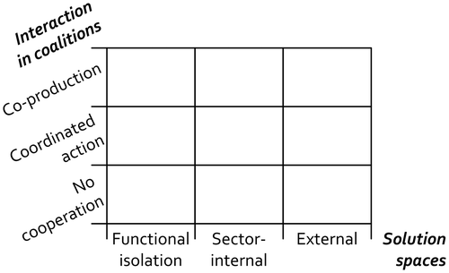
We can distinguish several degrees of integration. Analogous to Forester (Citation1985), these degrees may be coined “solutions spaces”. By looking at policy domains, three solution spaces can be distinguished (Table , see also Heeres et al., Citation2012a; Stead & Meijers, Citation2009). The conventional approach is to consider infrastructure issues as an isolated problem. The solution space of “functional isolation” is characterized by a relatively small spatial scope and a narrow functional scope. An isolated solution space addresses other land uses in a reactive manner, characterized by mitigation or compensation of negative effects. The scope of infrastructure planning could be expanded by including other modalities of the transport system. Such “sector-internal integration” seeks its solutions, for example, by considering infrastructure issues from a “daily urban systems” perspective. A daily urban system may be seen as the multimodal transport system (nodes and connections) that is used for commuting (van Oort, Burger, & Raspe, Citation2010). Hence, a daily urban system links the local and the regional scale (van der Laan, Citation1998). Internal integration takes a network approach and expands the solution space to other modalities within the transport silo. In contrast to internal integration, external integration takes into account a wide range of interrelated land uses within an area, including well-planned transport facilities. That way, it seeks to improve issues such as the general liveability, competitiveness and sustainability of an area (Dodson, Citation2009; Fischer & Amekudzi, Citation2011; Graham, Citation2009; OECD, Citation2010; Priemus, Citation2007).
Table 2. Solution spaces representing three ranges of functional integration.
Interaction processes: dealing with fragmented actors
As mentioned before, the actors that are responsible for the various interests at the infrastructure–land interface are often strongly fragmented. For example, these actors are embedded in different spatial-governmental scales, have different procedures and budgets, or have differing referential frames (Hull, Citation2008; Hysing, Citation2009; Kaufman & Smith, Citation1999). Scholars such as Mäntysalo et al. (Citation2011) and Van de Riet (Citation2003) indicate that these organizational mismatches can compromise the creation of legitimate policy support among public actors. Literature on collaborative planning and governance seems to suggest that regulatory organizational change is insufficient for addressing these issues (Legacy et al., Citation2012; Teisman & Klijn, Citation2002). Van de Riet (Citation2003) shows that the process of coalition building in itself is not enough: an excessive emphasis on dialogues and creating a policy support may create “negotiated nonsense”. Rather than involving larger numbers of actors in stakeholder coalitions, addressing fragmentation involves transforming the character and intensity of the interactions within these coalitions (Woltjer, Citation2000). Therefore, the extent of interaction among multiple stakeholders seems to be a second important parameter for studying integrated planning, in addition to the functional scope.
With regard to the extent of cooperation, three conceptual coalition types are relevant for this study (Table ; see also Stead & Meijers, Citation2009). First, the coalition type of “no cooperation” can be distinguished. In our explorations, this type serves to involve conventional governance styles based on hierarchies and central coordination. No cooperation may be associated with a closed governance style, which is characterized by hierarchical control and central coordination. Closed governance contrasts with open governance (Martens, Citation2007). Open governance implies networked decision-making and planning based on interaction between the actors involved (Legacy et al., Citation2012; Teisman & Edelenbos, Citation2011). Such networks possess capacities to address the fragmentation of interests and enhance the legitimacy of planning (Mäntysalo et al., Citation2011; Salet & Woltjer, Citation2009). Concerning open governance coalitions, we make a distinction between two types that pursue the creation of synergies between land use in fundamentally different ways: “coordinated action” and “co-production”. Coordinated action is concerned with improving the efficiency and legitimacy of sectoral policies by intensifying inter-sectoral coordination of interests. However, interactions remain superficial, due to a focus on sectoral policies (Van de Riet, Citation2003). Coordinated-action is not focused on achieving real synergies and system effects, in the form of broader social, economic and environmental goals for an area as a whole. In contrast, co-production pursues achievement of synergetic effects to enhance legitimacy through “an open dialogue in which, on a basis of equivalency and without prior conditions, opinions, conflicts, different values and power relationships are addressed” (Albrechts, Citation2013, p. 53; see also Huxham, Citation1993). Albrechts (Citation2013) also describes that governance processes, if organized in accordance with co-production, “can dramatically increase their resources, extend their reach, radically transform the way they operate, and be much more effective”.
Table 3. Three coalition types, representing increasing organizational integration between road infrastructure and other land uses.
An instrumental matrix
The content- and organization-related considerations above relate to two instrumental questions. First, what land uses should be integrated (solution space)? And second, to what extent should these land uses be integrated (interaction within coalitions)? Figure combines these conceptualization perspectives on integration in a comprehensive matrix. This matrix serves as a framework for our empirical explorations in Section 4. The vertical axis reflects the incorporation of interrelated land uses in the development of road infrastructure facilities and other land uses (Table ). Three conceptual “solution spaces” illustrate increasing integration with regard to taking into account interrelatedness at the interface between road infrastructure and other land uses. The vertical axis shows the conceptual degrees of the extent to which integration is carried through. That perspective on integration is reflected in the type of planning coalition (Table ).
Figure 1. Instrumental matrix of integration, revealing several conceptual types of integration. On the horizontal axis: three perceived solution spaces; on the vertical axis: the efforts made to achieve integrated coalitions.
3. Integrated infrastructure planning in the Netherlands
3.1. Dutch road infrastructure planning
We explored the Dutch road infrastructure sector to enlarge our knowledge of integration. In Dutch infrastructure planning, awareness of the need to deal with the interrelatedness of land uses within a fragmented institutional context is increasing. Attention to the complementarity of land uses has been on the policy agenda since 1998. In 1998, two advisory reports emphasized the need for stronger consideration of surroundings in road infrastructure development and vice versa in complex planning situations (RVW, Citation1998; WRR, Citation1998). An important impetus in practice was the integration of the planning, programming and budgeting systems for infrastructure and spatial development at the national level by the MIRT (Meerjarenprogramma Infrastructuur, Ruimte en Transport) [Long Term Programme for Infrastructure Space and Transport] in 2007. MIRT assembles all spatial plans and projects that receive national funding into a single comprehensive “Long Term Programme for Infrastructure Space and Transport” with a single procedural and budgetary framework (see e.g. OECD, Citation2010; V&W, Citation2007). In 2008, following the observation that planning and decision-making on Dutch infrastructure projects had been very slow, an advisory committee called for broad consideration of external relationships during the early infrastructure planning stages (V&W, Citation2008a). Since then, integrated strategies are increasingly propagated for programmes and projects that are part of the MIRT programme (see I&M, Citation2015). Nevertheless, the institutional context of integrated planning has remained fragmented. Practical application involves the cooperation of public actors who are nested at various spatial scales and each have different responsibilities, interests, procedures, rules and budgetary frameworks.
3.2. Two case studies
We studied two initiatives from the MIRT programme in order to gain a more nuanced view of the utilization and effectiveness of integration throughout infrastructure planning processes. In our case selection we made a distinction between the nature of initiatives. We selected a regional plan (Eindhoven, specifically the region’s eastern zone) and a concrete project (A2 Maastricht). Initially both initiatives had been approached as isolated infrastructural problems, but apparent interrelatedness with other challenges in the region caused considerable problems with time, budgets and stakeholder satisfaction. In order to overcome these problems both initiatives expanded their solution spaces and established coalitions of public authorities at the national, regional and local level.
The first step of our exploration was an extensive document analysis. By examining official project documentation and news media for changes in solution spaces and applied governance strategies, we gained insights into the application of integrated strategies throughout the various stages of the cases’ planning processes (see also Appendix A). Additionally, interviews were held with the programme and project managers responsible for these initiatives. Between them the interviewees covered all phases of the entire planning process (three people for Brainport, one for A2 Maastricht). These interviews aimed to record experiences in the establishment of integrated solution spaces and the interactions between actors. A second goal was to uncover the motivations that underlie this integration.
Section 4 describes the findings from the case studies. These are structured in accordance with the consecutive phases of the planning process. Several phases can be distinguished for both initiatives: an initial approach, a turn to integration (which provides a normative view: reasons for integrated plan making), followed by the implementation of integrated planning (providing an instrumental perspective, how integration is put into practice) and a final stage (which provides insight into the performance of integration until recently, as well as into the current status of the initiatives). For each stage the approaches to solution spaces and interaction in coalitions are analysed.
4. Integration throughout infrastructure planning processes
4.1. Completing the Eindhoven ring road
The city of Eindhoven and its surrounding region are known as the nation’s heartland for high-tech industries (Brainport 2020, Citation2011). Eindhoven is the fifth most populous city of the Netherlands. The completion of the Eindhoven ring road has been much explored over the past decades.
Initial approach and turn to integrated planning
The incomplete ring road around this medium-sized city had long been considered a flaw in national and regional transport networks. Discussions on improvement of the city’s major road infrastructures started in the 1970s; a formal planning procedure was first started in 1994. Studies showed that the region’s accessibility issues were a mix of problems, concerning transiting traffic as well as regional and local traffic. National, regional and local governments cooperated to find appropriate solutions (see also Niekerk, Citation2000). Despite the many studies and cooperation between layers of government, decision-making and realization proved difficult. The manager of the programme explained why:
Eindhoven had been muddling through on its accessibility issues for 30 years. These efforts focused on accessibility only. However, many spatial policy interests overlap in this area and accessibility improvements cannot be approached in isolation from other interests in the region. The solution requires additional efforts in the spatial planning sphere.
Examples of these spatial interests are housing location, nature and recreation, and the business locations that are important for the region’s economy (V&V, 2008b).
National and regional government aim to maintain and improve the region’s (and thereby the country’s) position in the European and worldwide high-tech sectors (VROM, LNV, V&W, & EZ, Citation2004). For that purpose, the Eindhoven region aims to attract at least 10,000 new highly educated professionals before 2030. This strategic agenda was the starting point for an explorative study, which provided a systematic view of the region’s infrastructure and other land uses (V&W, Citation2008b).
In the light of this agenda, the incomplete road network became an urgent matter. In 2006, an analysis of the regional transport network first hinted at the interrelatedness of accessibility and other land uses (i.e. economic development and attractiveness of the region; Brabantstad, Citation2006, p. 4):
[The Eindhoven region] has a strong economy and contributes a fundamental share to the Dutch economy […] To maintain this position, the region focuses on the accessibility of economic centres and on locations for housing development […] Accessibility improvements may however not impair liveability and environment. The strong connection between urban and green areas is a key asset of the region. The region wishes to maintain this strength […] Spatial development, therefore, must be coordinated with the strengths of the water system, with natural, landscape and historical values, and with the transport system.
The uncovered awareness of the interrelatedness of land uses in the Eindhoven region subsequently induced a turn from sectoral planning to integrated planning. Whereas the initial goal was the realization of a complete ring road (project implementation), the renewed goal was much more driven by a strategic plan for the region.
The programme manager illustrates the subsequent changes to the plans for the region:
Stakeholders had already developed several visions for the Eindhoven region, on different scales and on different themes. During explorative studies it became clear that these visions matched well. The idea was that a new range of different potential solutions would be opened up if we combined our visions.
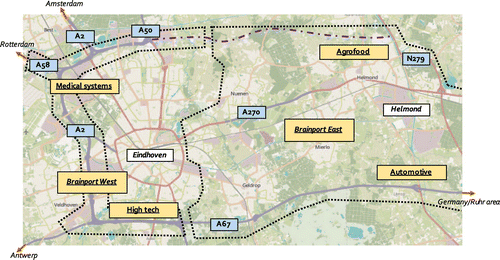
Following this awareness, the involved stakeholders engaged in an explorative study for setting up a regional spatial development programme. Instead of merely improving the city’s accessibility, the purpose of the new programme would be to serve all pillars that relate to the long-term socio-economic development of the region (Brainport 2020, Citation2011; Figure ).
Figure 2. Overview of development ambitions in the Eindhoven region, including economic sectors, infrastructure and green areas (© OpenStreetMap under CC BY-SA license).
Turn towards an integrated planning approach
Solution space. With this strategic agenda as the point of departure, the programme for the Eindhoven region had a combined focus on enhancing both sector-internal relations as well as external integration. Infrastructure improvements were identified as an important pillar in the accomplishment of the commonly shared regional development agenda. Improvements included enlargement of the existing capacity and completion of a wide ring road around the region. Additionally, the programme involved major investments in the improvement of public transport facilities in the region (V&W, Citation2008b). Moreover, the programme explored several locations that could potentially house the pursued population growth. In order to stimulate a high-quality living environment, culture and nature were also put on the agenda. The region’s central area was designated for protection from urban and transport development to enhance its position as a peaceful and quiet centre. The current A270 motorway was to be downgraded. The final priority consisted of sub-projects to strengthen ecological and water networks in the area and to enhance the possibilities for recreation (walking and cycling, see also V&B, 2008b).
The elements of the integrated ambition were seen as part of a coherent whole. Therefore, paring off elements was not considered to be an option:
All elements are equally necessary for the realization of our regional ambitions and strengthen each other […] We have agreed on a certain regional agenda [i.e. attracting 10,000 knowledge workers]. Reaching that ambition involves the infrastructures, mitigating and compensating measures, plus the other quality improvements [housing, recreation, nature].
A cost-benefit analysis (CBA) confirmed the coherence of the ambitions. The CBA sketched that costs and benefits were more or less balanced. As the programme involved very substantive investments in infrastructure works and public transport, this neutral picture was regarded as a positive outcome (Buck, Citation2009).
Interaction in coalition. The programme brought together the stakes of four national, one regional and many local actors (V&W, Citation2008b). A strong coalition of fragmented stakeholders formed the basis for the explorative studies and the formulation of a common ambition (TK, Citation2007). This coalition included multiple levels: various national government bodies, provincial authorities, a collaboration network of the five largest cities in the region, and the Eindhoven metropolitan board (representing 21 municipalities in the region). The infrastructure facilities in the Eindhoven region are part of national and regional networks. The national government was primarily interested in the road infrastructure works that are part of the national network of motorways. However, as the Eindhoven region is also a national spatial policy priority, the national government also had a stake in the overall development ambitions for the area. The regional and local authorities’ prime concerns were the regional infrastructure, public transport and the quality of the living environment. Further, regional and local concerns were maintaining the quality of the central area and improvements to water and the natural environment (see also V&W, Citation2008b, p. 219).
Sharing concerns, discussing potential combinations and integrating individual interests in the region created a new and broadly shared vision (V&W, Citation2008b). Due to the fragmentation of responsibilities, this process has not been straightforward. Crafting of the plan involved long discussions. The programme manager describes this as a co-production process:
A shared sense of urgency [and] a joint development ambition for the region are essential preconditions for the interactive process, but they are no guarantee for successful creation of a shared plan. We encountered numerous pitfalls. […] Examples that were experienced are a tendency to focus on the most prominent topic, accessibility, fragmented responsibilities, the time it takes to get all interests properly involved, and the proper discussion of opportunities for integration of these interests.
Implementation: again a sectoral approach
Solution space. After the strategic plan was crafted, the region was divided into a western and an eastern development zone so that more detailed project studies for the realization of the infrastructure and other ambitions could be carried out (Figure ).
Figure 3. Planned infrastructure construction and interventions in liveability in the north-eastern part of the Eindhoven region (© OpenStreetMap under CC BY-SA license).
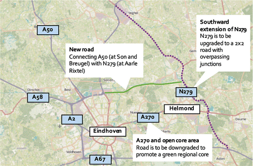
Currently, realization of the main infrastructures in the western zone has been completed. However, planning progressed slowly in the eastern zone. This zone comprised the completion of the ring road, in addition to the enhancement of the regional core as a green area (Figure ). The implementation of these parts of the regional vision was set up as sub-projects of the programme. The programme manager explained this approach:
The infrastructure projects that have come forward from our shared vision are large projects. Therefore, we needed a more focused approach, in which topics such as accessibility improvement and necessity of the project became more important than the underlying vision.
In the integrated regional vision, we stated that construction of a new road was to be accompanied by downgrading another existing road [motorway A270, in the middle the green core of the region]. However, the downgrading of this road is outside the scope of this sub-project [i.e. the completion of the ring road]. For us, these interventions are inextricable and also related to our housing programme. However, in the environmental impact assessment that must be prepared, we can only look at the negative effects of the new road. We cannot include the positive effects of downgrading of the existing motorway.
Interaction in planning coalition. In line with the lower degree of integration among land uses, interaction in the broad coalition also diminished; from co-production in the explorative stage to a lower level of coordinated action in the project studies in the eastern zone. Responsibilities for the programme’s sub-projects were distributed among the stakeholders: every organization took up its institutional tasks. The completion of the ring road became a task of the province, while the Eindhoven metropolitan board was given responsibility for measures in the green core. Support from the general public and local governments for the infrastructure developments in the eastern zone seems to have diminished during this more operational planning period (ED, Citation2014). The vanishing public support may be due to the narrow scope and mitigation-focused approach of the regional planning authorities and the changed approach to cooperation that was propagated. Due to this change, the synergy between the infrastructure works and other interventions clearly diminished.
The changed relations between the public authorities involved led to fierce discussions about the infrastructure ambitions between the stakeholders of the initial strategic plan. The stakeholders had great difficulty agreeing on the operational design of the road. In 2014, the national priorities for investment in transportation had changed, due to changing financial economic conditions. The Dutch parliament asked the responsible minister to reconsider the budgets that had been reserved for the completion of the Eindhoven ring road. For this purpose, a new CBA on the completion of the ring road was carried out. While the analysis presented a positive cost–benefit ratio, the non-monetizable effects (social effects, environmental effects) were all strongly negative (Decisio, Citation2014). On this basis, the national government decided to withdraw its support for the completion of the Eindhoven region ring road in late 2014 (VK, Citation2014). In early 2015, after the provincial elections, the regional government also changed its course and the completion of the ring road was cancelled (OB, Citation2015).
At the time of writing, other alternatives to strengthen the economic structure of the eastern part of the Eindhoven region are being explored. The current focus is on the improvement of existing national and regional road infrastructure (BD, Citation2015). Again, a coalition of regional actors has been founded. This time its goal is to explore measures for smarter use of existing infrastructure. The national government has already made €50 million available for these measures (Noord-Brabant & Limburg, Citation2015).
4.2. A2 Maastricht
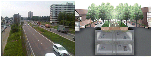
The A2 Motorway is one of the major international transport routes in the Netherlands, connecting Maastricht in the south-eastern corner to Amsterdam. The stretch of the motorway which passes through the city of Maastricht was designed as an urban boulevard in the 1950s. Since the 1980s this route has been recognized as a major bottleneck (see e.g. Verhees, Citation2013). It is, for example, the only section on route E25 (Rotterdam-Genoa-Palermo) where traffic is interrupted by multiple traffic lights and zebra crossings, combined with a speed limit of 50 km/h (Figure ).
Figure 4. The route of the A2 through Maastricht prior to redevelopment, showing the motorway as a barrier in the Maastricht urban environment, with traffic lights, zebra crossings and apartment buildings (left, source: Heeres) and the A2 Passage after redevelopment (right, source: A2 Maastricht, Citation2012).
Initial approach and turn to integration
In the 1990’s planning started to address the road’s congestion problems. Since the motorway was a national planning interest the project was undertaken by the Dutch national infrastructure planning agency. The project’s prime objective was to solve the problems that through traffic encountered on the motorway’s passage of Maastricht. However, the situation proved to be much more complex. As it turned out, local transport also encountered serious problems, for example with traffic cutting through residential areas. Liveability in the area was seriously disadvantaged due to the close proximity of transport to residential locations. Societal issues were prominent near the road, with disadvantaged social groups living in these areas. The road also formed a barrier, as it split the Maastricht urban system into two distinct halves. From a transport perspective, the obvious solution would be the construction of a new road to the east or west of the city. However, Maastricht is a compact city, with clearly demarcated boundaries and located in a highly valued green environment to the east and the border with Belgium to the west. Hence, local government strongly objected to the construction of a new road. This complex of interwoven issues introduced many additional demands from local stakeholders and led to higher costs than initially anticipated. When, at the end of 1998, infrastructure funds were drying up in the Netherlands, the project received low priority. The problems encountered were not assessed as severe enough to justify and fund purely top-down national action (AdB, Citation2002; Lenferink, Tillema, & Arts, Citation2009).
In 2000, the Minister of Transport re-announced the project as a public–private cooperation (Lenferink et al., Citation2009). Local and provincial government explored the feasibility of an integrated approach that simultaneously addressed the interrelatedness of interests and the funding issue by means of cooperation between public and private actors. The municipality then proposed to integrate the national, regional and local interests in the area in a shared project. In 2003, national, regional and local stakeholders formalized their support for this project in an administrative cooperation agreement (A2 Maastricht, Citation2003; EIA Commission [Commissie MER], Citation2004; Verhees, Citation2013).
Turn towards an integrated planning approach
Solution space. Concerning infrastructure–land use relations, the A2 Maastricht project emphasized external expansion of the solution space. An integrated plan was prepared to coherently address the interrelated transport and urban issues (Lenferink, Arts, Tillema, van Valkenburg, & Nijsten, Citation2012; Verweij, Citation2012). The interventions in infrastructure comprised the construction of a two-tier tunnel in order to move infrastructure out of the urban environment, and to separate local and through traffic. Subsequently, the spaces freed up by the tunnel construction were to be used for recreational amenities (an urban park) and the surrounding social housing was to be upgraded (AdB, Citation2002; see also Figure ).
EIA (Environmental Impact Assessment) and CBA studies were used to compare the proposed integrated solution to more conventional solutions (new roads east and west of the city). The results of these studies favoured the tunnel option. The EIA study (RWS, Citation2005) revealed that a tunnel was the best option for simultaneously addressing the problems encountered (through traffic, local traffic, and liveability). Furthermore, a tunnel offered the best opportunities for revival of the deprived areas surrounding the current road, and did the least damage to the natural environment of the city (RWS, Citation2005). Moreover, the construction of a tunnel appeared the most favourable alternative by ratio of costs and benefits as well; although it involved the highest costs, the benefits of the integrated plan were also the most significant due to shortened and more reliable travel times, as well as due to a rise in urban property values (Ecorys, Citation2006).
Interaction in planning coalition. The interrelatedness of interests caused a complicated situation in which multiple governmental levels (local, regional, national and even European due to the cross-border impact of the project) have a stake (A2 Maastricht, Citation2012). Stakeholders in this co-production were the Ministry of Infrastructure and Environment, the Province of Limburg, and two local municipalities (A2 Maastricht, Citation2003, 2012). The Ministry was primarily concerned with the position of the A2 passage in the wider national and international transportation networks. The provincial government sought to address regional transport problems, and the municipalities were mainly interested in urban liveability issues and local transport issues.
While this fragmentation had proved problematic in the past, the project manager explained the inducement for stakeholders to join the coalition by saying that “all governmental levels were tempted to participate, on the basis of the plan [to integrate the goals of the various stakeholders], with a substantially higher quality and lower price compared to isolated alternatives.” He goes on to highlight the coalition’s consciousness of the need to pay attention to the fragmented nature of the public stakeholders: “Our high levels of interaction will be maintained until the real estate realization to ensure that the envisioned overall quality of the developments is met.”
The interviewed project manager also explained how the coordination of fragmented interests has taken place among the public stakeholders. The key to the development of a plan that sufficiently addresses the interrelatedness of land uses was that “every actor has been able and capable to promote its own interests, while aiming to avoid obstructing other interests where possible”. Since “the organisation of the infrastructure planning agency is not equipped to deal with multiple interests”, the coordination had become the task of a collective project team. In this team, experts from the various stakeholders work together on a daily basis. The project manager interviewed stresses the importance of this direct form of cooperation:
We all had to make sure that the eventual plan suited the ideas and responsibilities of our organisations. By being a collective team, we learned a lot about each other’s interests […] All stakeholders worked from their own particular frames of reference and we needed to learn about our own and other’s priorities […] We had our discussions and conflicts, but these were kept behind the closed doors of our project office.
The involvement of private stakeholders appears to have been an important factor in the maintenance of an intense level of interaction and cooperation among public stakeholders. After the early explorative studies, planning and procurement procedures were innovatively combined (Lenferink et al., Citation2012; Verhees, Citation2013). Private consortia were invited to participate in a so-called competitive dialogue and to draw up proposals. The combination of infrastructure and real estate development appeared to be an attractive combination for market parties. During the project study phase, three consortia presented integrated project plans for the infrastructure problems and urban surroundings. Ultimately, the right to carry out the proposed design was awarded to a winning consortium selected by a jury (Lenferink, Tillema, & Arts, Citation2013). Solutions for the infrastructure issues (i.e. the construction of a tunnel) and attention to urban qualities were both important selection criteria in the procurement process. Due to this approach, private consortia were obliged to propagate and maintain the project’s externally integrated co-production ambitions, throughout the subsequent detailed project design as well as during realization. The project manager interviewed explained the advantages of the involvement of private stakeholders:
The market parties have shown the capacity to integrate knowledge on infrastructure and urban development. […] We [the national infrastructure planning agency] have an infrastructural focus, and therefore cannot do that. Infrastructure is leading in our planning decision-making. We have very few people with experience in urban and landscape design, and their ideas are often seen as unimportant. Infrastructures are leading in our planning and decision-making structures.
Implementation: maintaining the integrated focus
Construction works for the realization of the project started in 2012. This means that the integrated planning approach had taken more than 10 years. Nevertheless, the project manager regarded the approach that was carried out as successful:
We are getting the project done within the set budget and we get much more than initially anticipated […] The long planning period was mainly due to the dialogue with market parties. If we had not done that, we [the infrastructure planning agency] would have come up with an awful proposal and we would have failed once more. Our proposal would have raised so much opposition by other stakeholders that the costs of obligatory additional measures would have become unrealistically high.
Initially, exploration of potential synergies between infrastructure and other urban land uses appeared to be the main drive behind finding a viable solution to this persistent issue. But external interrelatedness remained an important feature throughout the later, more detailed project study stage as well. An important reason seems to be that these infrastructure and other land use functions are physically adjacent, and, therefore, were competing for space within the Maastricht urban area (A2 Maastricht, Citation2012).
5. Discussion of findings
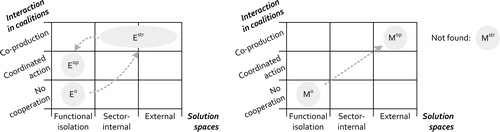
The case studies give insight into the development over time of integrated approaches in infrastructure planning. Both initiatives eventually turned to integration, when earlier, sectoral approached planning proposals had repeatedly failed to yield concrete results. The cases illustrate the differences between strategically inspired integration at the regional scale (Eindhoven) and operationally inspired integration at the local scale (Maastricht). Figure shows the paths that the integrated planning processes went through with regard to solution spaces and coalition types.
Figure 5. Integration matrices completed for the cases, showing the development of the Eindhoven (left) and Maastricht (right) cases over time. E, Eindhoven; M, Maastricht; 0initial sectoral approach; strintegration in strategic domain; opintegration in operational domain, see also Appendix A.
5.1. Turn to integration
After initial fruitless attempts, coalitions for co-production of plans and designs were eventually formed within both cases (see Figure ). These processes were characterized by learning as well as negotiations between actors (Woltjer, Citation2000). Close observation of the case descriptions reveal different accents regarding the formation of these coalitions.
The improvement of general socio-economic conditions in the region was the underlying motivation for a strategically motivated integrated planning approach in the Eindhoven region (Noord-Brabant, Citation2011; TK, Citation2007). To give substance to these ambitions, the involved actors engaged in a process of joint fact-finding, in which concerns were shared to combine national, regional and local interests. As such, the integrated process in the Eindhoven programme was initially characterized by learning between actors. The primary purpose of learning was to arrive at new knowledge about the essence of the problems in an area and to consequently identify potential synergies between road infrastructures and regional and local interests (see also Woltjer, Citation2000). Although learning was a prominent characteristic of the Eindhoven process, consensus-seeking also involved negotiations. Participants strongly defended their own interests in the discussions about the development of a strategic agenda, and concessions were made as trade-offs with other interests.
The operational case (A2 Maastricht project) was more straightforward from the start of integrated planning. The agreement between national, regional and local stakeholders clearly stipulated the construction of a tunnel and redevelopment of the directly surrounding urban areas (A2 Maastricht, Citation2003). The subsequent integrated planning process was, first of all, concerned with finding ways to achieve these operational aims. This involved discussions between stakeholders in order to find common ground as a basis for cooperating with a core interest (i.e. road infrastructure). This process was characterized by negotiations between the stakeholders. In these negotiations, the intended tunnel and adjacent land use developments (i.e. housing, recreational facilities) were specified, eventually arriving at what Woltjer (Citation2000) called a “win–win result”. As the interviews reveal, learning about mutual interests was a major feature of this project.
5.2. Follow up of integration
Operationalization of an integrated vision
In both cases, the expansion of solution spaces, co-produced by a coalition of actors, proved initially effective in overcoming a deadlock situation. In the case of the Maastricht project, the necessary project budgets have been raised and remain undisputed, procedures have been completed and construction works have begun. However, parts of the Eindhoven plan have ended in deadlock once more. During the detailed project study in the Eindhoven case, a change in dealing with interrelatedness and fragmentation can be observed (Figure ). The difference with the earlier explorative planning stage is particularly apparent from the operationalization of the programme in its eastern zone. These detailed project studies can be characterized as a conventional infrastructure planning process. During this stage the interaction in the planning coalition degraded from co-production to coordinated action. Instead of attempting to further exploit potential synergies between the proposed road infrastructure interventions and directly surrounding land uses, the efforts focused on mitigating negative environmental effects of the infrastructure. It was assumed that the basis of a strategically motivated integrated vision for the Eindhoven region was sufficient to legitimize the works for completing the ring road. However, during this stage the interrelatedness of land uses concerned local issues, i.e. issues in the direct spatial adjacency of road infrastructure interventions. Examples were surrounding spatial functions such as nature, recreation and culture–historical elements (e.g. VK, Citation2014). As a result, the programme encountered fierce implementation problems. Problems were characterized by a lack of public support, and a renewed debate over the programme’s purpose and the assigned funds. These caused considerable delays, and eventually cancellation of the ring road project.
Success factors
In contrast, the A2 Maastricht project has been able to hold on to its initial sense of urgency for dealing with interrelatedness. After its turn to integration, the project has maintained a high level of functional and organizational integration from the early project stages through to realization (Figure ). This shows that formal procedures and maintaining a manageable span of control are not necessarily problematic for maintaining an integrated focus. Rather, it was the involvement of market parties and the integrated contracting which assured that an integrated focus was maintained in this case. The integrated business case, procurement efforts and the resulting integrated contract with private developers (including infrastructure construction as well as land use redevelopment) enforced on-going interaction between public stakeholders. Another success factor was the enduring solid public support for the Maastricht project. This public support, established through an extensive public participation strategy, has made it politically easy for public actors to remain involved. The Eindhoven ring road lacked such a strategy. In that case, negative public opinion about the infrastructure emerged, making it difficult for public actors to participate in a legitimate and co-productive manner.
A multi-level view on integration is needed
Compared to the Eindhoven case, the change between strategically and operationally motivated planning is much less clear in the Maastricht case (Figure ). After a quick explorative study on the feasibility of the intended integrated solution, integration remained in the operational domain for the rest of the process. Since the experienced interrelatedness mainly concerned direct and physical relations between the infrastructure and other land uses that surround the road, this operational approach has proven to be effective throughout the process.
Because of this focus on the operational domain, however, more strategic and indirect functional relations with other developments or ambitions elsewhere in the wider region have not been taken into account. For example, the potential future development of the Maastricht station area, office locations and industrial locations were not considered. Also, the potential for multi-modal synergies has not been exploited, as other transportation modes remained outside the project’s scope. Once finished, the project is expected to deliver substantive liveability improvements for the area directly surrounding the tunnel. However, the role of this tunnel development within the regional daily urban system remains unclear, due to the lack of a strategic vision. As the tunnel reaches completion, discussions are beginning to arise as to how to redevelop the area directly around the tunnel (housing and office development; A2 Maastricht, Citation2015), as well as how to link this area to the wider urban region (e.g. creating stronger links to the railway station and the city centre; Maastricht, Citation2008).
A viable long-term agenda would require a strategic vision similar to the one developed in the Eindhoven case. Such a vision should describe the more strategic aspects of this operationally driven project, i.e. the tunnel’s relations with other transport modalities, transport hubs and spatial development priorities within the Maastricht region.
This discussion illustrates that a viable integration is not either strategically or operationally motivated. Rather, addressing the interrelatedness of infrastructure and other land uses involves attention to integration at the strategic as well as the operational level of infrastructure planning.
6. Concluding remarks
This study has portrayed integration at the infrastructure–land use interface as a dual effort of acknowledging functional interrelatedness by means of the establishment of multi-actor coalitions. It has linked the motivations for turning to an integrated approach in road infrastructure development and the implementation of integrated planning to the various stages of the planning process.
The study illustrates that integrated planning approaches help to facilitate dealing with functional interrelatedness and stakeholder fragmentation. However, this may happen in different ways throughout the different stages of the planning process. This paper shows that two types are distinguishable: (1) integrated developments inspired by strategic considerations, and (2) integration for operational purposes.
The primary concern of strategic integration processes is to strengthen the socio-economic perspectives of a region (daily urban system) for the longer term. Both the network view of internal integration as well as external integration’s search for synergies with land uses in other policy silos are relevant for such efforts. At the operational level, the efforts of integration are more concerned with addressing implementation problems that can be linked to project support issues in the short term. Such efforts focus on the relations between different land uses (external relations) that are physically adjacent, and which are therefore competing for space.
The cases highlight that an elevated extent of interaction among involved actors is required in order to successfully deal with interrelatedness and fragmentation: co-production, which focuses on exploiting system complementarities, rather than on sectoral optimization. This focus is lacking in more straightforward coalitions such as coordinated action (Table ). Coordinated action is therefore less equipped to address these challenges. Our case studies show two characteristics of the co-production of visions, plans and designs: learning and negotiations. In addition to our conceptualization of coalition types, the case studies show that the character of consensus-seeking is different for strategic and operational integration. Within strategic integration, the emphasis of co-production is primarily on learning about mutual interests and the interrelatedness of interests. Within integration for operational reasons, co-production places more emphasis on negotiations about a specific area’s physical urban or landscape design.
The case studies have shown that the nature of interrelatedness may change as planning processes proceed. In the Eindhoven case, a clear development from strategic to operational interrelatedness of land use functions can be observed as the programme proceeded from the creation of a long-term agenda to the implementation of sub-projects. During this process the overall regional joint objectives faded into the background and the interaction between the involved public actors weakened. In Maastricht the emphasis of integration has long been on addressing operational issues. As the tunnel construction is reaching completion the project lacks a strategically inspired integrated strategic vision at the city-regional level, which would have provided meaningful guidance for the project’s next steps. Our case study illustrates that effective application of integrated planning strategies should therefore not be static, but dynamic. Integration is a multilevel effort. Strategic regional visioning must be followed up by attention to the operational level, concerned with the implementation of plans at the local scale. Equally, the formulation of an integrated local design needs to be accompanied by at least an exploration of how this local design is strategically embedded within the larger region.
Finally, we conclude that dynamic integrated planning is not necessarily hampered by sectoral planning formalities (as was claimed by interviewees in the Eindhoven case). Rather, an integrated approach needs to be secured by appropriate institutional mechanisms. Two examples of such mechanisms can be found in the A2 Maastricht case: firstly, the involvement of private developers and their enforced on-going interaction between public stakeholders, secondly, the enduring solid public support for the Maastricht project which has made it politically easy for public actors to remain involved. A third mechanism that has come forward from both cases is the need to develop an understanding for each other’s referential frames, either through discussions (Eindhoven, development of the regional vision) or by setting up joint project teams (Maastricht).
Disclosure statement
No potential conflict of interest was reported by the authors.
Funding
The research for this article was carried out as part of the programme ‘Towards sustainable road infrastructure’. The programme is funded by Rijkswaterstaat, the executive agency of the Dutch Ministry of Infrastructure and the Environment.
Notes on contributors
Niels Heeres is a PhD candidate at the Faculty of Spatial Sciences, University of Groningen. His research focuses on the interaction between land uses in infrastructure planning strategies. He currently works at Sweco as a mobility advisor.
Taede Tillema was a senior researcher at the Faculty of Spatial Sciences, University of Groningen. He is now working at the Netherlands Institute for Transport Policy Analysis.
Jos Arts is a professor in environmental and infrastructure planning at the Faculty of Spatial Sciences, University of Groningen. He also works as a strategic scientific adviser at the executive agency of the Dutch Ministry of the Infrastructure and the Environment.
Related Research Data
References
- A2 Maastricht. (2003). Bestuursovereenkomst A2 Passage c.a. Maastricht [Administrative agreement A2 Maastricht]. Ministry of Transport and Waterworks, Province of Limburg, Maastricht Municipality, Meerssen Municipality.
- A2 Maastricht. (2006). Samenwerkingsovereenkomst A2-Maastricht [Cooperation agreement A2 Maastricht]. Ministry of Transport, Public Works and Water Management, Province of Limburg, Municipality of Maastricht, Municipaility of Meerssen.
- A2 Maastricht. (2012). Een plan voor stad en snelweg [A plan for city and highway]. Maastricht: Projectbureau A2 Maastricht.
- A2 Maastricht. (2015). Extra kansen voor Maastricht Oost [Extra chances for Maastricht eastside]. Retrieved October 25, 2015, from http://www.a2maastricht.nl/nl/meer-weten/page_nieuws.aspx?id=3058
- AdB. (2002). Maastricht raakt de weg kwijt II [Maastricht looses the road]. Holten: Aveco-de Bondt.
- Albrechts, L. (2013). Reframing strategic spatial planning by using a coproduction perspective. Planning Theory, 12, 46–63. 10.1177/1473095212452722
- Amekudzi, A., & Meyer, M. D. (2006). Considering the environment in transportation planning: Review of emerging paradigms and practice in the United States. Journal of Urban Planning and Development, 132, 42–52. 10.1061/(ASCE)0733-9488(2006)132:1(42)
- Arts, J. (2007). Nieuwe Wegen? Planningsbenaderingen Voor Duurzame Infrastructuur [New Roads? Planning approaches for sustainable infrastructure]. Groningen: University of Groningen.
- Baccarini, D. (1996). The concept of project complexity – a review. International Journal of Project Management, 14, 201–204. 10.1016/0263-7863(95)00093-3
- Baker, M., & Hincks, S. (2009). Infrastructure delivery and spatial planning: The case of English local development frameworks. Town Planning Review, 80, 173–199. 10.3828/tpr.80.2.4
- Banister, D., Anderton, K., Bonilla, D., Givoni, M., & Schwanen, T. (2011). Transportation and the environment. Annual Review of Environment and Resources, 36, 247–270. 10.1146/annurev-environ-032310-112100
- BD. (2015). Geen Ruit, maar wel bestaande, slimme wegen [No ring road, but smarter existing roads]. Brabants dagblad, 13 may 2015. Retrieved October 1, 2015, from http://www.bd.nl/regio/brabant/geen-ruit-maar-wel-bestaande-slimme-wegen-1.4919671
- Bertolini, L. (2012). Integrating mobility and urban development agendas: A manifesto. disP-The Planning Review, 48, 16–26. 10.1080/02513625.2012.702956
- Brabantstad. (2006). Netwerkanalyse Brabantstad [Network analysis Brabantstad]. Brabantstad cooperation network.
- Brainport 2020. (2011). Top economy, smart society: Visie, strategie en uitvoering [Top economy, smart society: Vision, strategy and implementation]. Eindhoven: Brainport Development NV.
- Buck. (2009). Kosten-batenanalyse op hoofdlijnen [CBA main points]. The Hague: Brainport Eindhoven / A2-zone.
- Busscher, T., Tillema, T., & Arts, J. (2013). Revisiting a programmatic planning approach: Managing linkages between transport and land use planning. Planning Theory & Practice, 14, 492–508.
- Cervero, R. (2009). Transport Infrastructure and global competitiveness: Balancing mobility and livability. Annals of the American Academy of Political and Social Science, 626, 210–225. 10.1177/0002716209344171
- Collingridge, D. (1983). Hedging and flexing: Two ways of choosing under ignorance. Technological Forecasting and Social Change, 23, 161–172. 10.1016/0040-1625(83)90051-3
- Decisio. (2014). MKBA Ruit Eindhoven: Maatschappelijke kosten en baten van de voltooiing van de Verkeersruit rond Eindhoven [CBA Eindhoven Ring Road. Societal costs and benefits of the completion of the Eindhoven Ring Road]. ‘s Hertogenbosch: Province of North Brabant.
- Dodson, J. (2009). The ‘infrastructure turn’ in Australian metropolitan spatial planning. International Planning Studies, 14, 109–123. 10.1080/13563470903021100
- Drewe, P. (2011). Mixed scanning new style: A useful tool for Poland? In M. Kolzynski, & P. Zuber (Eds.), New paradigm in action: Recent developments and perspectives of regional policies (pp. 37–42). Warsaw: Ministry of regional development.
- Ecorys. (2006). Kentallen kosten-batenanalyse project A2 [CBA A2 Maastricht]. Maastricht. Rotterdam: Ecorys.
- ED. (2014). Uitkomst steekspel Ruit ongewis [Outcome of ring road debate remains unclear]. Eindhovens Dagblad, 28 februari 2014. Retrieved June 20 2016, http://www.ed.nl/mening/uitkomst-steekspel-ruit-ongewis-1.4239014
- EIA Commission [Commissie MER]. (2004). A2 passage Maastricht: Advies over aanvullende richtlijnen voor het milieueffectrapport [Advice about additional guidelines for EIA]. Netherlands commission for environmental assessment, reportnr. 744–133.
- FEHRL. (2013). Transport infrastructure integrated with land use planning (TILUP): A road map for research. Brussels: Forum of European National Motorway Research Laboratories.
- Fischer, J. M., & Amekudzi, A. (2011). Quality of life, sustainable civil infrastructure, and sustainable development: Strategically expanding choice. Journal of Urban Planning and Development, 137, 39–48.
- Forester, J. (1985). Designing: Making sense together in practical conversations. Journal of Architectural Education (1984-), 38, 14–20. 10.1080/10464883.1985.10758365
- Graham, S. (2009). Networked infrastructure and the urban condition. In T. Rieniets, J. Sigler, & K. Christiaanse (Eds.), Open city: Designing coexistence. Amsterdam: SUN.
- Graham, S., & Marvin, S. (2001). Splintering urbanism, networked infrastructures, technological mobilities and the urban condition. London: Routledge. 10.4324/9780203452202
- Hamersma, M., Tillema, T., Sussman, J., & Arts, J. (2014). Residential satisfaction close to motorways: The impact of accessibility, nuisances and motorway adjustment projects. Transportation Research Part A: Policy and Practice, 59, 106–121.
- Heeres, N., Tillema, T., & Arts, J. (2012a). Integration in Dutch planning of motorways: From “line” towards “area-oriented” approaches. Transport Policy, 24, 148–158. 10.1016/j.tranpol.2012.08.002
- Heeres, N., Tillema, T., & Arts, J. (2012b). Duurzame planning van weginfrastructuur: Een internationaal perspectief’, report for Rijkswaterstaat [Sustainable road infrastructure planning: An international perspective]. Groningen: University of Groningen.
- Herder, P. M., Bouwmans, I., Dijkema, G. P. J., & Stikkelman, R. M. (2008). Designing infrastructures using a complex systems perspective. Journal of Design Research, 7, 17–34. 10.1504/JDR.2008.018775
- Hertogh, M., & Westerveld, E. (2010). Playing with complexity: Management and organization of large infrastructural projects. Rotterdam: Erasmus University.
- Holland, J. H. (1998). Emergence: From order to chaos. Oxford: Oxford University Press.
- Hull, A. (2008). Policy integration: What will it take to achieve more sustainable transport solutions in cities? Transport Policy, 15, 94–103. 10.1016/j.tranpol.2007.10.004
- Huxham, C. (1993). Pursuing collaborative advantage. Journal of the Operational Research Society, 44, 599–611. 10.1057/jors.1993.101
- Hysing, E. (2009). Greening transport – explaining urban transport policy change. Journal of Environmental Policy & Planning, 11, 243–261.
- I&M. (2015). MIRT Overzicht 2016 (MIRT programming overview 2016). The Hague: Ministry Infrastructure & Environment.
- Kaufman, S., & Smith, J. (1999). Framing and reframing in land use change. Journal of Architectural and Planning Research, 16, 164–180.
- Legacy, C., Curtis, C., & Sturup, S. (2012). Is there a good governance model for the delivery of contemporary transport policy and practice? An examination of Melbourne and Perth. Transport Policy, 19, 8–16. 10.1016/j.tranpol.2011.07.004
- Lenferink, S., Arts, J., Tillema, T., van Valkenburg, M., & Nijsten, R. (2012). Early Contractor involvement in dutch infrastructure development: Initial experiences with parallel procedures for planning and procurement. Journal of Public Procurement, 12(1), 1–42.
- Lenferink, S., Tillema, T., & Arts, J. (2009). Marktbetrokkenheid in infrastructuurplanning: Stilstand voorkomen door als overheid minder zelf te doen? [Market involvement in infrastructure planning: Preventing delays through public action]. Paper presented at CVS-conference 2009, Antwerp.
- Lenferink, S., Tillema, T., & Arts, J. (2013). Public-private interaction in contracting: Governance strategies in the competitive dialogue of dutch infrastructure projects. Public Administration, 91, 928–946. 10.1111/padm.2013.91.issue-4
- Maastricht. (2008). Stadsvisie 2030 [Urban vision 2030]. Municipality of Maastricht.
- Mäntysalo, R., Saglie, I. L., & Cars, G. (2011). Between input legitimacy and output efficiency: Defensive routines and agonistic reflectivity in nordic land-use planning. European Planning Studies, 19, 2109–2126. 10.1080/09654313.2011.632906
- Martens, K. (2007). Actors in a fuzzy governance environment. In G. de Roo & G. Porter (Eds.), Fuzzy planning: The role actors in a fuzzy governance environment (pp. 43–66). Aldershot: Ashgate.
- Mouter, N., & Annema, J. A. (2010). Synergie-effecten van ruimtelijk-infrastructurele projecten [Synergy effects of infrastructure-land use projects]. Paper presented at CVS-conference 2010, Roermond.
- Neuman, M. (2006). Infiltrating infrastructures: On the nature of networked infrastructure. Journal of Urban Technology, 13, 3–31. 10.1080/10630730600752728
- Niekerk, F. (2000). Het effect geraporteerd: De gebruikswaarde van effectrapportages voor de planning van verkeersinfrastructuur [The effect reported: The use of effect analysis for infrastructure planning]. Groningen: Geopers.
- Noord-Brabant. (2011). Structuurvisie ruimtelijke ordening Noord-Brabant: Deel D Brainport Oost [Structure vision Noord Brabant: Part D Brabant East]. ‘s-Hertogenbosch: Province of Noord-Brabant.
- Noord-Brabant & Limburg. (2015). Bereikbaarheid Zuid-Nederland: samen slim robuust. Provinces of Noord Brabant, Province of Limburg and 139 regional partners. Retrieved from http://onlinepublisher.nl/Brabant/2015/BidB.html
- OB. (2015). Aanleg Ruit rond Eindhoven verder weg na verkiezingen: Brabanders af van gezondheidsproblemen [Realization of Eindhoven Ring Road on hold after elections: Health problems avoided]. Omroep Brabant, 19 march 2015 (accessible through:) Retrieved October 1, 2015, from http://www.omroepbrabant.nl/?news/226474992/Aanleg+Ruit+rond+Eindhoven+verder+weg+na+verkiezingen+%E2%80%98Brabanders+zijn+af+van+gezondheidsprobleem.aspx
- OECD. (2010). National place-based policies in the Netherlands. Paris: Organization for Economic -operation and Development.
- Peek, G.-J. (2006). Locatiesynergie: Een Participatieve Start Van De Herontwikkeling Van Binnenstedelijke Stationslocaties [Location synergies: A participative approach to redevelopment of inner urban locations]. Delft: Eburon.
- Priemus, H. (2007). System innovation in spatial development: Current Dutch approaches. European Planning Studies, 15, 992–1006. 10.1080/09654310701448147
- Ruth, M. (2010). Economic and social benefits of climate information: Assessing the cost of inaction. Procedia Environmental Sciences, 1, 387–394. 10.1016/j.proenv.2010.09.026
- RVW. (1998). Ambities bundelen: Advies over de Inpassing van Infrastructuur [Bundling ambitions: Advice about the alignment of infrastructure and surroundings]. The Hague: Raad voor Verkeer en Waterstaat.
- RWS. (2005). ‘Eén plan voor stad en snelweg Onderzoek alternatieven en varianten A2-passage Maastricht’ [EIA A2 Maastricht] [One plan for city and highway. Study about alternatives A2 Maastricht]. Maastricht: Rijkswaterstaat.
- Salet, W., & Woltjer, J. (2009). New concepts of strategic spatial planning dilemmas in the Dutch Randstad region. International Journal of Public Sector Management, 22, 235–248.
- Stead, D., & Meijers, E. (2009). Spatial planning and policy integration: Concepts, facilitators and inhibitors. Planning Theory & Practice, 10, 317–332.
- Teisman, G. R., & Edelenbos, J. (2011). Towards a perspective of system synchronization in water governance: A synthesis of empirical lessons and complexity theories. International Review of Administrative Sciences, 77, 101–118. 10.1177/0020852310390121
- Teisman, G. R., & Klijn, E. H. (2002). Partnership arrangements: Governmental rhetoric or governance scheme? Public Administration Review, 62, 189–198.
- Tillema, T. (2012). Trends in American transportation planning, with a specific focus on sustainability. Groningen: University of Groningen & Rijkswaterstaat.
- TK. (2007). Bijlage 1 Netwerkaanpak: uitkomsten bestuurlijk overleg voorjaar 2007 [Appendix 1 Network approach: Outcomes of political deliberations spring 2007], Tweede Kamer [Dutch House of Representatives], Br. 1542.
- V&W. (2007). MIRT projectenboek 2008 [MIRT Project overview 2008]. The Hague: Ministry of Transport, Public Works and Water Management.
- V&W. (2008a). Actieplan Sneller en Beter [Action plan Faster and Better]. The Hague: Ministry of Transport, Public Works and Water Management.
- V&W. (2008b). MIRT-Verkenning Zuidoostvleugel Brabantstad [MIRT Explorative studies Brabantstad southeast wing]. The Hague: Ministry of Transport, Public Works and Water Management.
- Van Buuren, A., Buijs, J. M., & Teisman, G. (2010). Program management and the creative art of coopetition: Dealing with potential tensions and synergies between spatial development projects. International Journal of Project Management, 28, 672–682. 10.1016/j.ijproman.2009.12.002
- Van de Riet, O. (2003). Policy Analysis in multi-actor policy settings; Navigating between negotiated nonsense and superfluous knowledge. Delft: Delft Univeristy of Technology.
- van der Brugge, R., Rotmans, J., & Loorbach, D. (2005). The transition in Dutch water management. Regional Environmental Change, 5, 164–176. 10.1007/s10113-004-0086-7
- Van der Heijden, J. (2010). Combineer wat je hebt: duurzaamheid door het verbinden van maatschappelijke functies [Combine what you have: Sustainability by integrating societal functions]. Delft: Uitgeverij Eburon.
- van der Laan, L. (1998). Changing urban systems: An empirical analysis at two spatial levels. Regional Studies, 32, 235–247. 10.1080/00343409850119733
- van Oort, F., Burger, M., & Raspe, O. (2010). On the economic foundation of the urban network paradigm: Spatial integration, functional integration and economic complementarities within the Dutch randstad. Urban Studies, 47, 725–748. 10.1177/0042098009352362
- Verhees, F. (2013). Publiek-private samenwerking: Adaptieve planning in de praktijk [Public-private cooperation: Adaptive planning in practice]. Groningen: University of Groningen.
- Verweij, S. (2012) .‘Management as system synchronization: The case of the Dutch A2 passageway Maastricht project’, Emergence: Complexity and Organization, 14, 17–37.
- VK. (2014). Ruit rond Eindhoven in de prullenbak: kamer stemt tegen [Eindhoven Ring road rejected by parliament]. Volkskrant, 27 november 2014 (accessible through:) Retrieved October 1, 2015, from http://www.volkskrant.nl/binnenland/ruit-rond-eindhoven-in-de-prullenbak-kamer-stemt-tegen~a3799813/
- VROM, LNV, V&W, & EZ. (2004). Nota Ruimte: Ruimte voor ontwikkeling [National spatial plan: Space for development]. The Hague: Ministries of VROM, LNV, V&W and EZ.
- Wegener, M., & Fürst, F. (2004). Land-use transport interaction: State of the art. Dortmund: Universität Dortmund.
- Williams, T. M. (1999). The need for new paradigms for complex projects. International Journal of Project Management, 17, 269–273. 10.1016/S0263-7863(98)00047-7
- Woltjer, J. (2000). Consensus planning: The relevance of communicative planning theory in Dutch infrastructure development. Aldershot: Ashgate.
- WRR. (1998). Ruimtelijke ontwikkelingspolitiek [Spatial development politics]. The Hague: Wetenschappelijke Raad voor Regeringsbeleid.
- Yu, N., de Jong, M., Storm, S., & Mi, J. (2013). Spatial spillover effects of transport infrastructure: Evidence from Chinese regions. Journal of Transport Geography, 28, 56–66. 10.1016/j.jtrangeo.2012.10.009
- Zonneveld, W., Waterhout, B., & Trip, J. (2009). Van projectologie naar planologie en vice versa [From project planning to strategic planning and vice versa]. Delft: TU Delft.
Appendix A
Milestones in the Eindhoven region’s development (with a focus on the region’s eastern zone)
Milestones in the A2 Maastricht development