
Abstract
This paper examines the introduction of land-use planning requirements into the regularization process of informal settlements in areas designated as “conservation land” in Mexico City. Since 1997, the government has increasingly deployed digital technologies to map and track informal settlement in conservation land in order to select those eligible for reclassification as “residential land use”: a prerequisite for other stages in the regularization process, including property titling, access to urban services and subsidised loans for home improvements. We argue that the incorporation of land use planning into the discursive and material enactments of regularization continues to reproduce the social class divisions behind the otherwise rather tenuous distinction between formal and informal urban development. Although presented as a technical concern by planners, regularization remains embedded in political processes and outcomes, a characteristic long recognised in the abundant literature on the subject. What is new is the geo-referencing of informality as part of land use planning, as this alters the dynamics of regularization processes, now involving the everyday planning practices of local government. This experience thus suggests the need for re-conceptualising informality as a form of selective spatial regulation and governance integral to the planning and urban development process.
Introduction
Recent debates on urban development in Mexico City narrate three parallel processes that challenge the legitimacy and conventional perceptions of planning. After years of population decline, a surge in medium and high-rise housing and commercial developments in central areas is transforming the skyline. On the metropolitan periphery, urban growth continues in both developer-driven “formal” and so-called “informal” or “irregular” settlements of various types and origins.Footnote1 Conflicts arising from all three types of development have catapulted the issue of land use planning into a prominent position in media coverage and public debate in Mexico’s capital. Regarding new developments in central areas, commentators flag issues long associated with market-led neoliberal urbanism, such as displacement, gentrification and rising land prices.Footnote2 Criticisms also highlight the shady practices whereby the state modifies zoning regulations in favour of new developments, further worsening traffic congestion and the saturation of urban services. Violations of existing norms and planning failures are also linked to social and environmental problems associated with the massive housing developments that have proliferated around Mexican cities since the mid-1990s, often in inaccessible and ill-serviced areas (Esquivel, Maya, & Cervantes, Citation2005). Meanwhile, the ongoing expansion of more affordable incrementally-built settlements in peripheral areas is blamed for environmental problems and inadequate housing conditions. These settlements have traditionally been considered “uncontrolled” and “outside” of the formal planning system, but their “irregularity” has mainly been defined in terms of property titling issues. Inside Mexico City, however, “irregular” increasingly refers to the violation of land use regulations, specifically in the so-called “conservation zone” on its southern periphery.
These debates over land use conflicts highlight the discretional way the state mediates access to land through “formal” and “informal” development processes in different areas of the city. Although the legality of all three types of development can be questioned, distinction between what is “formal” and “informal” is perpetuated through differentiated discursive framings and selective interventions justified by reference to planning objectives. To put it bluntly: the violation of planning norms and other illegalities in developer-driven projects in both central and peripheral areas does not make them “informal.” On the other hand, self-built, incremental settlements are invariably labelled as “informal” or “irregular” and, therefore, need to be “regularised”.
This paper seeks to contribute to debates that explore informality and formality as “forms of practice” (McFarlane, Citation2012). However, rather than focusing on “how informality and formality fold into one another” as related but distinct practices (McFarlane, Citation2012, pp. 90, 103), this paper emphasizes the new role of routine planning processes in defining and enacting informality. We are particularly interested in exploring the recent political and social dynamics of “constructing informality” through procedures to change land use from “non-urban” to “residential”, as the necessary prelude to other stages of “doing regularization”, including land-titling, urban service provision in informal settlements and interest-free credit for home improvementFootnote3. We also use the term “doing regularisation” in a more critical sense to convey the discretional, protracted and convoluted nature of this process which may or may not lead to formal “regularization” as a concrete outcome, leaving many settlements in a kind of regulatory “grey zone” or limbo (Wigle, Citation2014).
Our research explores how relatively recent digital mapping technologies are used in conjunction with land-use plans and regulations to manage the regularization processes of informal settlements in the conservation zone. The focus of the paper is not on whether plans are implemented or not, but rather, on the political and social uses of planning discourses and practices. To this end, the research traces the role of local government in “constructing informality” and “doing regularization” as part of a “calculated informality that undergirds the territorial practices of the state” (Roy, Citation2009, p. 82). Ultimately, this analysis of territorial practices brings us back to the foundational issues of socio-economic inequality and access to land and housing.
The article is divided into three sections. The first examines how informality is related to governmental practice both in recent English language literature and in not-so-recent Mexican scholarship on the subject, much of it published in Spanish. We also sketch out the linkages between the concepts of “constructing informality” and “doing regularization.” The next section explains the basics of urban planning in Mexico City, including the ambiguous delimitations of “conservation land” and how the regularization of settlements located there is now integrated with land use regulations and procedures and an expanding suite of digital mapping tools and other spatial calculation techniques. The third section discusses the results of empirical research based on a series of semi-structured interviews conducted between 2011 and 2015 with government officials, local leaders and residents of informal settlements in conservation land.Footnote4 We use this field research to argue that “doing regularization” as a planning exercise, far from eliminating the “formal-informal” distinction, reinforces the class distinctions, social exclusion and political control traditionally associated with informality in Latin America. The research also exposes the increasing interconnection of informal settlement with planning and its related tools of spatial calculation, thus debunking conceptions of informal settlement as being “outside” of the planning system and shifting the analytical focus of regularization to include land use regulation.
The choice of the study area is significant and needs clarification; even within the Mexican context, Mexico City is an exceptional case. The nation’s capital, until recently called the “Federal District” (DF),Footnote5 houses 8.8 million people, about 44% of the metropolitan population, as well as containing substantial areas of forest, hillsides, agricultural holdings and villages in what is zoned as “conservation land” in the southern part of the city. Unlike the rest of the metropolitan area and many other Mexican cities, the DF has no designated land reserves, so any urban expansion here violates primary zoning regulations. It is also virtually impossible to officially change the primary zoning status from “conservation land” to “urban land”, except for the purpose of regularizing pre-existing settlements, as analysed below. In many other urban areas, especially the adjacent Mexico State, it is relatively simple to officially re-classify land-use from “not urbanizable,” “ecological preservation,” “green area,” agricultural use and so forth, to “urban reserve” or even residential and other urban uses.Footnote6 One reason for this is that municipalities (not state-level governments or the city government in the case of Mexico City) are responsible for land use planning in the rest of the country. However, because of its special status as the nation’s capital, Mexico City’s central government is ultimately in charge of planning the whole territory, leaving the lower level entities or boroughs certain tasks in its implementation.Footnote7 On the other hand, these distinctions are becoming less important and, as public policy in the capital is often copied in the rest of the country, irregular settlement is becoming increasingly linked to violations of zoning regulations.
Informality and Regularization as Governmental Urban Practice
In Mexico City, over half the population, including much of the middle class, can only access housing through informal or irregular settlement processes, either because their income is insufficient or for other reasons that make them ineligible for mortgage credit or legal rental contracts. Informal settlement processes are therefore responsible for housing 59% of Mexico City’s populationFootnote8 (Connolly & Castro, Citation2016), although this percentage is gradually decreasing due to a cheaper and more abundant social housing supply (Connolly, Citation2009). This situation reflects Mexico’s longstanding social inequality combined with the absence of a more comprehensive affordable housing policy. The preponderance of informal housing also stems from Mexico’s mostly “laissez-faire” approach to irregular settlement, explained by some as a state strategy to cheapen the cost of labour (Connolly, Citation1982; Pradilla, Citation1981), as well as the consequences of the 1910–17 Mexican Revolution which reinforced the social acceptance of everybody’s right to a “piece of land” (Connolly, Citation2017). However, “laissez-faire” does not mean passive. In the Mexican context, it has involved the mobilization of different strategies to manage the access of lower-income households to land, housing and urban services or what Gill (Citation2000) calls the “multiple measures – discourses, political practices, laws and, of course, repression – that the state uses in attempting to resolve the tensions between its economic policies and the political necessities that arise from them” (p. 10).
Latin American informal or irregular settlement or “habitat popular” is generally understood to combine the following characteristics: unauthorised land subdivision, often implying hazardous environmental conditions; illegal property transactions and lack of title deeds; and an initial lack of urban services (e.g. water and sewerage) and precarious housing conditions (Duhau, Citation1998, p. 77). Depending on income levels and perceptions of tenure security, settlements tend to improve over time as residents invest in housing and urban services, with or without government assistance (Turner, Citation1966). As many informal settlements are thus progressively consolidated and upgraded, Duhau (Citation2014) has called this a “generally accepted urban process” related to the “normalization of the informal housing land market” (p. 153). Research in Mexico has also drawn attention to “ancestral spaces” (Duhau & Giglia, Citation2008) or the “continuity of rooted structures – built forms, institutions, uses and customs, spatialized human relations” in shaping settlement expansion processes which may fall outside the perception of “formal” development or planning (Connolly & Cruz, Citation2004, p. 446).
Government responses to informality in Latin America have traditionally involved property titling and, to a lesser extent, upgrading of urban services, a process generally referred to as “regularization.” Historically, settlements in Mexico have been considered “regularized” when title deeds are issued, a process involving the intervention of diverse and often competing state agencies, depending on the original property status of the land.Footnote9 Moreover, maintaining the status of being “regularized” involves continuous efforts to remain in compliance with legislation concerning property, tax and inheritance issues over time, as the original owners die or move out (Ward, Citation2012). The predominant policy focus on land titles in Mexico, rather than on land use authorisation, is echoed in longstanding debates on the regularization of informal settlements (De Soto, Citation2000; Fernandes & Varley, Citation1998). Huaman (Citation2010) even criticises regularization programmes in metropolitan Mexico City for their complete disregard of planning and building regulations.
Most authors include in their definition of informality or irregularity the lack of compliance with the norms that govern urban development, an inevitable result of incremental construction (Duhau & Schteingart, Citation1997). While urban regulations may change over time, informal settlements are therefore associated with operating at the “margin of urban norms” (Duhau & Cruz, Citation2006) or infringing planning laws and regulations (Azuela, Citation1989; Connolly, Citation1990, Citation2009). As Azuela and Meneses-Reyes (Citation2014) argue, however, being at “the margin of the state does not mean being completely disconnected from its institutions, but in an ambiguous situation in relation to them” (p. 176). In practical terms, this ambiguity means that while informal settlements may violate planning norms, the programs for regularizing them are embedded in state institutions and political considerations. Indeed, the institutionalization of regularization programs in Mexico underlines the pervasive nature of state intervention in informal urbanization (Azuela, Citation1987; Duhau & Cruz, Citation2006). A key dynamic of this relationship is the degree to which regularization processes depend on “governmental largesse” and the “political subordination” of settlers (Azuela & Meneses-Reyes, Citation2014, pp. 180–181). Most often, the regularization process therefore involves some form of political negotiation and struggle implicated with the clientelistic practices of the Mexican state (Azuela & Meneses-Reyes, Citation2014; Duhau, Citation2014; Varley, Citation1993, Citation1996, Citation1998).
Research both inside and outside of Mexico is instructive for highlighting the complex articulations of informality with the state, its planning apparatus and urban development. For example, Roy (Citation2005) views informality as a mode of metropolitan urbanization, rather than as the binary “other” to the formal sector. She argues that informality is “produced by the state itself” (Roy, Citation2005, p. 149), echoing similar arguments made previously by Azuela (Citation1987) about the integral role of the Mexican state in defining the parameters of informality. Consistent with this view, McFarlane and Waibel (Citation2012) see informality as a “governmental tool” used to justify different forms of state intervention. In Mexico, informal settlement has long been recognised as a vehicle of political control through clientelistic co-option that reproduces social inequalities (Cornelius, Citation1975; Connolly, Citation1982; Eckstein, Citation1977; Ward, Citation1998; Varley, Citation1998). These studies have documented the relationships between state agencies and patron-client networks for “delivering the goods” (Varley, Citation1996) such as land titles to regularize informal settlements, with a focus on federal institutions and property regularization.
This paper adds to this extensive research on the political nature of regularization processes in Mexico, but shifts the focus towards the role that everyday land use planning practices play in governing informal settlement and regularization processes – and in shaping urbanization patterns more broadly. Following Blomley’s work (Blomley, Citation2003, p. 122) on “doing property”, we argue that plans, regulations and practices contribute to the re-construction of informality in as much as these are directly linked to the discursive and material enactments of regularization by government agencies. In this way, “conceiving of informality as a set of practices rather than a territorial formation challenges the supposed “illegality” of slums, set against the apparent “legality” of formal urban development” (McFarlane, Citation2012, p. 106), while also recognizing the “transactive” rather than discrete relations between formal planning and informal settlement (Porter, Citation2011). We further add to these debates by linking the analysis of these “transactive” practices between informal settlements and planning to the prospects and realities of regularization processes enacted in Mexico City.
Land-use Planning in the “Urban” and “Conservation” Zones of Mexico City
Since the Spanish colonization, strict regulations have dictated how Mexican cities should develop. These were re-elaborated in the nineteenth century to accommodate hygienic and sanitary concerns and, throughout the twentieth century, various cities had their own urban development plans. In 1940, the first of several “regulating plans” and zoning laws were authorised for the DF, strongly biased towards roadway design but with some consideration for conserving green areasFootnote10. These plans were implemented piecemeal, ignoring large swathes of territory, while many upmarket urban developments had their own internal regulations. The idea that the whole territory should be planned was not expressed until the nationwide General Law for Human Settlements was passed in May 1976, dictating that all municipalities should have urban development plans, as well as the larger cities, while each federal state should pass its own urban development legislation. The plans would not only lay out general growth strategies, but also establish land use zoning. Importantly, new projects would need a land use certificate, which in turn, was necessary for obtaining construction and other licenses, as well as registering property transactions (DOF, Citation1976).
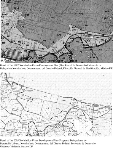
Five months previously, in January 1976, the DF was the first federal entity to pass its own law, which substituted the previous planning legislation of 1953 (DDF, Citation1976). The new law classified the DF’s territory into two primary zones: one for urban development and the rest for ecological conservation (DDF, Citation1976; Art. 46). At the time, these zones were not mapped out in detail; they could not have been as large-scale cartography did not exist. After various versions of legislative reform and failed plans, a definitive plan was drawn up in 1987, designating 63,382 hectares for “urban development” and 85,554 hectares for “ecological conservation” (DDF, Citation1987). Although the 1:50,000 scale paper maps at that time provided only an approximate delimitation between urban and non-urban areas, the 1987 primary zoning has been reproduced in the subsequent urban development plans of 1996 and 2003, with slight adjustments to the aerial calculation as digital cartographic technology improved. Thus, in the most recent Urban Development Plan of 2003, 61,081 hectares are recognised as “urban land”, while the remaining 88,442 hectares are “conservation land” (GDF, Citation2003; p. 25). A significant difference is that digital cartography now enables a more accurate calculation of the areas involved (Figure ). The process of delimiting the conservation zone was mostly an exercise of fitting the fuzzy 1987 line onto larger-scale maps, while the precise boundaries between urban and conservation land depend on the cartographic projection and scale. The communities concerned were not consulted during those years and, in any case, the language of zoning and the cartographic representation of space was little understood outside the circles of planners, architects and geographers. In fact, prior to the advent of digital cartography and high resolution satellite images, large scale maps of human settlements outside the core areas of cities were simply not available.Footnote11
Figure 1. Comparison of zoning maps, selected area of the conservation zone, Xochimilco, Mexico City (1987, 2005).
The term “conservation land” suggests a misleading unity far removed from its social and territorial complexity. On the ground, it is a diverse and complicated terrain of forests, rivers, agricultural and livestock production, as well as mining, industrial and recreational activities, interspersed with different property types and a wide variety of settlements. These include 36 rural towns and villages, many of prehispanic origin with longstanding social practices and religious festivals linked to the governance of community life. Outside the 1987 boundaries of these towns and villages, urban developments on conservation land are designated as “irregular settlements”, numbering an estimated 867 and housing 50,703 families (Castillo, Citation2014).Footnote12 Another source indicates that irregular settlements cover approximately 3,000 hectares or 3.17% of the conservation land (SMA, Citation2013, p. 36).
Approximately 70% of the conservation land in the DF is communal property (Sheinbaum, Citation2011, p. 17), either historically constituted community lands around rural villages or ejidos: the land restored to peasant communities under the post-revolutionary Agrarian Reform between 1916 and 1992. These communal holdings have provided a significant source of land for irregular settlements around Mexican cities, not least in the capital city. Property regularization was subject to federal agrarian law, although the related institutional framework changed over the course of the twentieth century, adding to the existing complexities of the process.Footnote13 Federal agrarian agencies set the framework for the governance of communal and ejido land, including its transition from collective to private property. This changed with constitutional reform in 1992 allowing for the privatization and sale of agrarian property under certain conditions (Assies, Citation2008; Salazar, Citation2012). Despite these changes to national legislation, local ejido and community assemblies continue to exert influence over these processes and transactions. The regularization of informally-settled ejidal land anywhere in the country now requires municipal approval (Salazar, Citation2012), although this does not always occur in practice.
Land use planning in Mexico City’s conservation zone falls primarily under the auspices of two agencies of the Mexico City government: the Secretariat of Urban Development and Housing (SEDUVI), responsible for the “General Program of Urban Development of the Federal District,” and the Secretariat of the Environment (SMA) in charge of the “General Program for Ecological Regulation of the Federal District”. Published in 2003 and 2000, respectively, these plans are now not only outdated, but also widely criticized for their ambiguous and contradictory zoning regulations (Aguilar & Santos, Citation2011; Eibenschutz, Citation2008; Schteingart & Salazar, Citation2005). Although both SEDUVI and SMA have undertaken recent efforts to update these plans, neither has been approved yet (December 2016).Footnote14 Planning in the conservation zone is also influenced by local urban development plans drawn up for each of the boroughs. The latter show the permitted secondary zoning or land use at the scale of each block (refer back to Figure ) and are supposed to be consistent with the overall planning directions established in the general urban and ecological plans mentioned above. The actual process of coordinating plans among these various actors, however, has been a “serious problem” as both SEDUVI and the boroughs have shown reluctance to consider the Environment Secretariat’s Ecological Regulation programme in local development plans (Interview 7, July 2012).Footnote15 According to SMA’s annual report (2013), the two agencies have worked together on the harmonization of their respective plans – and their base cartography – in order to express “one vision” for the conservation zone and achieve a more “integrated and effective approach for its sustainable development” (p. 37).
In spite of the earlier lack of cartographic precision and contradictory classifications, the 1987 division between “urban” and “conservation” land has been accentuated over time through the adoption of distinct planning policies, discourses and related practices in each zone. This division is also underpinned by an increasingly functional relationship between the two zones, with conservation land now positioned in many official planning documents as providing vital “environmental services” to urban residents, such as biodiversity protection and carbon capture.Footnote16 Most importantly, the conservation land in the DF (and in bordering municipalities in Mexico State) is depicted as being vital to recharging the aquifer. Not only does the DF draw approximately 41% of its drinking water from the aquifer, but also its overexploitation is linked to the city’s subsidence and resulting damage to buildings, housing and infrastructure (SMA, Citation2013).
Typically, planning documents point to the “anarchic urban occupation” in conservation land as one of the “principal factors of environmental degradation” (GDF, Citation2003, p. 25). Policy responses to this degradation have promoted market-oriented conservation measures such as payments to agrarian communities for environmental services (Shapiro, Citation2013). A range of agricultural and conservation initiatives concerning conservation land are now supported in the name of protecting environmental services. For example, the “Environmental Agenda for Mexico City” (SMA, Citation2008) states that “conservation land is vital for the well-being of the inhabitants [of the city] for the environmental services that it provides” (p. 8) and recommends the “application of normative instruments and regulation related to land use in the conservation zone for the control and planning of irregular human settlements” (p. 10). A report by SEDUVI (Citation2013) emphasizes the same message, stating that the conservation land “possesses characteristics that, as well as supporting the existence of invaluable flora and fauna, offer environmental goods and services to the benefit of the entire population of the Federal District” (p. 33). In a more foreboding tone, SMA (Citation2013) mentions that the “continuing loss of conservation land will possibly put the city’s sustainability at risk” (p. 34). Similar themes and even the exact wording from official planning reports are echoed by other actors, including the media:
Irregular settlements damage the environment…in recent decades the conservation zone in the Federal District has been affected by urban expansion. This is considered an ecological zone that provides environmental services vital to maintaining the quality of life of residents of the capital (CitationEl Universal, 2013).
The borough of Xochimilco was one of the first to implement the new land use planning approach to contain informal settlement in the conservation zone, but it has since been adopted in other boroughs with conservation land, such as Tlalpan (see Aguilar, Citation2008; Aguilar & Santos, Citation2011) and Tláhuac. This approach is new, insofar as it emphasizes land use permits as part of the regularization process and relies upon the extensive use of spatial technologies, such as satellite images, aerial photography and other geo-referenced data to map, categorize and monitor irregular settlements in the conservation zone (Wigle Citation2010, Citation2014). This also allows for the rapid and precise linking of databases with spatial objects at a variety of scales and the longitudinal study of settlement expansion.
Doing Regularization in the Conservation Zone
While laws and regulations guide the broad outlines of these policies, informality and regularization are largely enacted through the everyday planning practices of the local state or borough. This section analyses recent field research conducted in Xochimilco and Tláhuac (2011–2015), two of the three boroughs that contain most of conservation land in Mexico City. The 2005 local urban development plan for Xochimilco articulates the basic framework for the new strategy for managing informal settlement in the conservation zone (GDF, Citation2005). Tláhuac followed suit in 2008 with the approval of its local urban development plan (GDF, Citation2008). As voiced by a senior SEDUVI official, the purpose of this new approach is “to try to give legal certainty to the residents of these zones, these settlements. What the government wants to avoid is to be seen turning a blind eye: ‘we see that you are here, but we’re going to act like you’re not’” (Interview 3, July 2011). Indeed, this approach makes informality visible to the state and other actors in ways that influence the negotiation process over regularization.
Although there are differences on paper and in practice, the overall approach for managing informal settlement in conservation land in Xochimilco and Tláhuac shares common elements. The general baseline is the inventory of informal settlements in the conservation zone, now tracked and updated by SMA on a regular basis. At the borough level, this inventory is complemented with a more detailed community-based assessment of informal settlements.Footnote18 As part of this assessment, each settlement is delimited by spatial coordinates defining its “polygon”.Footnote19 This geo-referencing of informality has become more accurate in recent years, as one official who worked with SEDUVI and Mexico City’s ombudsman for environmental and territorial planning (PAOT) explained:
When this exercise began, which started in SEDUVI in 2005, it was done with (aerial) photography from (the year) 2000 – a difference of 5 years. In 2008, it was done with 2005. But in 2010, it was done with information from 2010. That was a big advantage. We have very reliable information and very detailed. So the polygons (of the irregular settlements) can be established with greater detail. It’s very important, the geographic information system, it has become the essential tool for determining everything from location, analysis, prognosis, proposals, actions (Interview 8, July 2012).
Figure 2. Mapping of little polygons as part of “doing regularization”, Xochimilco, Mexico City. Source: Based on Gobierno del Distrito Federal (2007) Estudio Específico. [Name of settlement removed]. Unpublished report. México DF.
![Figure 2. Mapping of little polygons as part of “doing regularization”, Xochimilco, Mexico City. Source: Based on Gobierno del Distrito Federal (2007) Estudio Específico. [Name of settlement removed]. Unpublished report. México DF.](/cms/asset/c3d6ff89-a4dd-4682-9e1e-a6bdcb99f76b/rptp_a_1279678_f0002_b.gif)
According to planning officials, the community-based assessment of irregular settlements considers various factors: the degree of housing consolidation, population, area, current legal land use and proximity to existing urban areas. Community surveys are combined with aerial photographs and digital mapping to “close the polygon” of the settlement, a boundary-setting exercise with material implications for its path towards regularization. According to a planning official in Xochimilco, mapping is vital for “tak(ing) decisions and establish(ing) the policies for each space” (Interview 1, July 2011). The importance of these spatial calculation exercises for “closing the polygon” can also incite the promotion of counter-mapping proposals from affected communities:
Yes, we submitted some plans…the plans that we submitted include all of the polygon, that is to say, all of La Loma [name of community]. All of this we’re still waiting on. Some time ago, we hired some people to draw the polygon…they (the borough) have a copy of our polygon (Interview 2, July 2011).
If I (speaking as local government) start doing the study for you, automatically 50 more (people) appear (in the settlement). So then you are contributing to speculation. You are saying “Yes, I’m going to regularize” so then everyone goes there and takes advantage of what’s on offer and more conservation land is lost (Interview 8, July 2012).
According to local officials, these community-based assessments inform the classification of informal settlements into three categories: (1) “special regulation zones”, (2) “special study zones” and (3) “control zones” in Xochimilco or “zones subject to diagnosis” in Tláhuac.Footnote20 These categories have implications for regularization, as those settlements placed in the category of “special regulation zone” are deemed most eligible to receive the coveted land use change to residential land use, a key step in the regularization process in the conservation zone.Footnote21 Settlements excluded from this category face a longer and more uncertain trajectory towards regularization. Dividing informal settlement into these categories also introduces a discursive element to “doing regularization,” whereby the borough may enhance a settlement’s regularization prospects without making any material investment in the community.
Even those settlements placed in the category of “special regulation” proceed towards land use regularization through an onerous and opaque process. According to both boroughs’ urban development plans, this process includes additional studies to examine the urban and environmental impacts of regularization.Footnote22 Like the community assessments, these studies become part of an expanding sequence of planning practices involved in the protracted process of “doing regularization” in informal settlements in conservation land. To initiate a land use change, the borough must submit a report that integrates these studies and proposes in situ mitigation measures for a settlement area.Footnote23 The report is submitted for deliberation to a tripartite committee known as the “Commission for Special Regulation” composed of representatives from the borough, SEDUVI and SMA. The committee’s role is to review the report, negotiate the terms for regularization (or not) and issue a positive or negative dictum regarding land use changes and regularization. This includes how residents will compensate for the loss of environmental services related to their settlement in the conservation zone.Footnote24 A SEDUVI representative involved in this process describes the contents of one such report:
So, the report arrives here and we review it. It’s a document with 17 pages, 18 pages, with a map, a plan that indicates the polygon of the settlement and the name of the (property) owners, and an agreement that the borough makes with the settlement in which they (residents) agree they will pay and that the only beneficiaries will be those who are in that polygon (Interview 9, August 2012).
Although the overall deliberation process of the tripartite committee appears to take years, an official with SEDUVI suggested that most discussions so far have tended to favour regularization (Interview 9, August 2012).Footnote25 This tendency is the cause of some tension among the different actors involved, as relayed by a SMA official: “what’s certain is that it (the commission) has also been an instrument geared towards regularization, rather than containment or protection” (Interview 7, July 2012). On the other hand, an official at SEDUVI was more positive in their assessment of the commission’s work: “I believe in the Commission as an instrument to orient growth, to detain urban sprawl a little and order the territory” (Interview 6, July 2012). Of all the actors involved, however, it is the borough government that faces the most direct social pressure from settlements to show that they are pushing a particular file forward. A community leader in Tláhuac told us how the borough sent personnel to help residents clean up the settlement before an impending site visit from SMA and SEDUVI representatives (Interview 2, July 2011).
The tripartite committee’s final dictum stipulates the conditions under which land use regularization can proceed, if at all. If the dictum is “positive”, the report will include details related to payments for environmental damages, as outlined previously. In Xochimilco, each household should pay into a special fund established to support the proposed in situ mitigation measures. Footnote26 In theory, households who complete these payments are eligible to receive their land use change certificate for their respective lot. The certificate is needed to register their property in the DF and for property titles to be issued.Footnote27 This is what a local planning official in Xochimilco called a “liberated lot”, referring to its release from land use restrictions aimed at ecological conservation (Interview 1, July 2011). A resident of an irregular settlement in ejido land in Tláhuac expressed it somewhat differently, emphasising security of tenure:
The constancia (a document provided by ejidal authorities to convey occupancy permission) doesn’t provide security (of property). What we want is to have property titles (escrituras), registered by the corresponding authorities, that say “This is yours, the title is in your name” – because they made the land use change and – “here are all the documents required by this process, it’s all included” – and they give us the go-ahead (visto bueno) – and now “here are your titles, sign them, this is your land and no one is going to be able to take it away from you” (Interview 2, July 2011).
In practice, it is at this stage of the regularization process that everything slows down. In an effort to accelerate the process, Xochimilco began grouping their defined “polygons” or settlements into “regions” to avoid detailed studies for each “little polygon” (Interview 1, July 2011). Still, as of June 2015, only two positive “regional” dictums had been successfully negotiated and issued for Xochimilco and none in Tláhuac, and neither of these had been legally registered. One of these dictums was issued in July 2011 for a region including eight communities in Xochimilco categorized as both “special regulation” and “specific study”, although little has happened since. Barrio Caltongo, one of the communities included in this “regional” dictum is a traditional barrio or quarter of the pre-hispanic town of Xochimilco.Footnote28 The community has a sixteenth century chapel, but was made “irregular” by the 1987 primary zoning map. Typically, longstanding residents in such towns tend to question the legitimacy of state intervention in local affairs (see Crossley, Citation2011). Aware of these tensions, a planning official in Xochimilco explained that Barrio Caltongo will not be asked to pay compensation for environmental damages as part of their land use regularization process:
Caltongo is pure barrio. You can’t ask an original barrio of Xochimilco to pay me a fine for being there because they were there before any law…especially them, that barrio, their chapel is from about 1590, so to say to them: “hey, pay me”… well, they’ll tell me to go to hell (Interview 4, June 2012).
So far, we haven’t completed any paperwork; it was the local government’s initiative at that time to undertake the community walk-abouts (recorridos). It seems that this process of changing land use can’t be done overnight, it’s a process of community visits, studies, drawing maps, investigation. It seems that the project takes about 8 years to become law. The map that they are now showing us includes lands and properties that will have the land use change. They handle many versions (of the maps), but they are now showing it to us because it’s election time. Unfortunately, much of this work is subject to electoral timing (Interview 5, June 2012).
There are norms in each program that you can put into action. I believe that what’s important here is knowing how to use planning. Legislators may be the ones taking decisions, but the ones who know are the planners, we are the ones who are really doing/making the norms (italics added, Interview 1, July 2011).
Conclusions
By analysing the workings of the planning system in the conservation zone on the southern periphery of Mexico City, this paper demonstrates how digital mapping and spatial calculation is affecting the social construction and regulation of “informal” settlement by the local state. At the city-level, planning regulations and small-scale zoning maps have redefined “irregularity” in terms of land use. Informal housing is now perceived and represented cartographically; it is now very much “on the map” and subject to planning regulations. On the ground, the everyday planning practices of borough officials enact the twin processes of “constructing informality” and “doing regularization” in individual settlements, using large-scale cartographic representations made possible by digital mapping, satellite imagery and geo-referencing technologies. In the process, not only the planning personnel but also the communities themselves learn and appropriate the language of spatial representation generated by these technologies. Informality, thus represented, appears as a technical outcome, disguising the political nature of the negotiations, determining where to draw polygons and what aspects of a settlement to geo-reference. These outcomes are now vital for a community to take further steps in the regularization process, with important material implications in terms of accessing property titles, urban services and even some social programs.
These interventions are justified in planning discourses that focus on the “chaotic” nature of informal settlements, or increasingly, on their “disruption” of ecological spaces and the environmental services provided by conservation land. It is reasonable to suppose that the introduction of regularisation by planning has limited urban expansion into conservation land to the south of Mexico City to some extent, but has not prevented substantial population growth in these areas. At best, it has pushed urban expansion into the neighbouring municipalities of Mexico State. Meanwhile, the 50,000 or more families living in existing, expanded or new settlements within Mexico City’s conservation land are caught up in endless procedural machinations which will decide their fate: whether they will be allowed to follow the conventional path of regularization, land-titling and assimilation into the urban fabric, or whether they will continue to be classified as “irregular” and thus deprived of access to basic amenities and urban services. In other parts of the city, and even within the conservation zone, construction sites regularly violate planning norms without acquiring the “irregular label”. By focusing on the selective and discretionary nature of state regulatory practices in informal settlements, the paper excavates the rather tenuous distinction between formal and informal urban development and shows how the state uses this trope to reproduce social class divisions in managing access to land and housing.
Disclosure statement
No potential conflict of interest was reported by the authors.
Notes on contributors
Priscilla Connolly is Distinguished Professor in Urban Sociology and the Metropolitan Planning Programme at the Universidad Autónoma Metropolitana (Azcapotzalco) in Mexico City, where she has lived and worked since 1972. She has published several books on housing and public works policy, and numerous articles and book chapters on Mexico’s construction industry, urban economy, and housing and planning challenges. Some of her most recent research documents the history of informal housing in Latin America.
Jill Wigle is Associate Professor in the Department of Geography and Environmental Studies at Carleton University in Ottawa. Her research focuses on access to land and housing, planning practices and the spatial governance of informality in Mexico City.
Funding
Funding for this research was provided by the Social Science and Humanities Research Council of Canada (SSHRC) Standard Research Grant/410-2011-2427.
Acknowledgements
The authors would like to acknowledge the excellent research assistance of Ana Luisa Diez García, Héctor Hernán Hidalgo Páez and Andrea Carrión, and to thank local residents and planning officials who took the time to participate in interviews for the research, as well as three anonymous reviewers for their helpful comments on an earlier version of this article.
Notes
1. Informal and irregular settlements are used interchangeably in this paper. “Informal” is more commonly used in English-language urban literature, while “irregular” is more widely used in Spanish-language literature. “Informal settlement” is described in greater detail in the next section of the paper.
2. The following newspaper articles illustrate these debates. On changes in land use regulations and densification, see Pascoe (Citation2014) and Quintero (Citation2012); on escalating land prices, displacement and gentrification, see Gómez (Citation2014a) and González and Gómez (Citation2015); on conflict of interests, corruption and failure to enforce planning regulations, see Cruz (Citation2014) and Llanos (Citation2014); on community resistance to new developments and demands for inclusion in planning decisions, see Gómez (Citation2014b) and Salgado (Citation2014) and on the unfettered power of private interests and developers to determine development outcomes, see Díaz (Citation2013).
3. Since 2001, the Mexico City government has run the Housing Improvement Programme providing non-mortgage loans of 1,000 to 3,000 US dollars to low-income families who live on their own property for the purpose of home improvement or reconstruction (FOSOVI, Citation2009; INVI, Citation2015). This programme only operates in “regularized” or “regularizing” settlements that conform with primary zoning regulations.
4. See Appendix A for a list of interviews used for this paper.
5. We use “Mexico City” and “Federal District” (DF) synonymously in this article. The term “Federal District” has been recently rendered obsolete and is substituted by “Mexico City” with the Constitutional reform of 29 January 2016 which granted political autonomy to the entity. In addition, we use the term “metropolitan Mexico City” or “metropolitan area” to refer to the entire metropolitan area.
6. The term varies from municipality to municipality, and within a single municipality there may be various types of land use designated as “not for urban use”.
7. The DF (now Mexico City) is comprised of 16 boroughs or “alcaldías” (previously called “delegaciones”), although only nine of these contain conservation land. Each borough has an elected head and is responsible for a range of local services, including minor building permits. The boroughs participate in the elaboration of their urban development plans and urban services, but are not directly responsible for these, which are generally drawn up by private consultants hired by the city government.
8. This percentage is 65% for the whole metropolitan area (Connolly & Castro, Citation2016).
9. Huaman (Citation2010) provides a detailed analysis of property regularized in metropolitan Mexico City. Based on annual reports of the 10 organisations involved, this author estimates that between 1971 and 2002, 1,233,041 plots were regularised, 42.4% in the DF and 57.4% in municipalities in the metropolitan zone. Somewhat less than two-thirds of these plots were in settlements developed on private property, while the rest were in agrarian community holdings.
10. On the history of planning in Mexico City, see Hiernaux, Citation1989; Sánchez Citation2002, Citation2013; for the implications of the history of urban planning on the Latin American concept of “informal”, see Connolly, Citation2017.
11. This affirmation is based on one of the author’s personal experience working as a planning consultant in Mexico in the 1970’s and 1980’s.
12. The 2003 Urban Development Plan estimated that there were a total of 708 human settlements in conservation land in 2000, of which 528 were “irregular”, and a total of 59,302 families living on 3,134 hectares in this zone (GDF, Citation2003, p. 25). It is important to note that not all informal settlement is related to low-income households, but also includes some more affluent households (Schteingart & Salazar, Citation2005).
13. There is a considerable literature in English on the urbanization of Mexican agrarian communal property that contributes to critical research on “informal settlement”. For example, see Azuela (Citation1987), Connolly (Citation2017), Cymet (Citation1992), Varley (Citation1985, Citation1998), Vázquez (Citation2004), and Salazar (Citationforthcoming).
14. After fourteen months of deliberations and public hearings, the “Project for the General Program of Urban Development of Mexico City” was at last presented for approval to the Mexico City Legislature, November 23 2016. Interestingly, the figures presented in this project and general policy outlook concerning irregular settlments in conservations land reproduce those presented in the 2003 General Urban Development Plan (Mancera, Citation2016, pp. 54–55).
15. The authors have translated the quotes from government documents and interviews included in this paper.
16. See, for example, the “Green Plan” (2007) and the “Environmental Agenda” (2008–2012) for the DF.
17. These “payments for environmental damages” are outlined in the next section.
18. According to SMA’s official inventory, Tláhuac has 93 irregular settlements in 436 hectares and Xochimilco has 309 irregular settlements on 625.5 hectares of conservation land (SMA, Citation2013, p. 36).
19. The spatial coordinates that define the polygon are entered into digital mapping systems used to define the boundaries of a specific settlement and its categorization in terms of local plans or land use regulations. Such boundaries may be contested, transforming the “polygon” into a socio-technical construct with implications for regularization.
20. The most recent figures available indicate that approximately half of the irregular settlements in Xochimilco and 58 settlements in Tláhuac are classified in the first two categories. We use the word “inform” here to indicate that political discretion may trump the community assessments. Our field research suggests that these assessments are likely more comprehensive in Xochimilco than Tláhuac, although it has been more difficult to obtain both interviews and information from planning officials in Tláhuac.
21. Usually, planning officials (except those from SMA) and residents simply refer to residential land use as “land use” (uso de suelo), thus positioning it as the default land use and others as the residual ones. For example, a SEDUVI official once referred to this as “give them a land use” (darles un uso de suelo) (Interview 3, July 2011).
22. We have been able to review one of these impact studies in Xochimilco, but not in Tláhuac. Similar to the urban development plans at the borough level, additional studies are undertaken by private consultants.
23. “Mitigation measures” might include, for example, the use of permeable pavement materials to lessen the impact of settlement in the conservation zone.
24. Government officials of Xochimilco reported that these payments for “environmental damages are calculated by estimating the loss of rainwater infiltration based on construction volume, the size of the lot and its location” (Interview 9, August 2012). In Tláhuac, the local plan refers to the donation of 10% of the area within a settlement’s polygon to permit rainwater infiltration in lieu of payments, although it is not clear if all regularizing settlements will be asked to do so (GDF, Citation2008). To date, it has not been possible to confirm actual payment details with local planners.
25. The tardiness of the process is likely attributable to the studies required, as well the fact that these commissions are not always active. Undoubtedly, there are political considerations involved as well.
26. According to interviews, the policy calls for these fines to be paid over a 3-year period to an independent fund and then re-invested in “mitigation measures” to minimize the impact of settlement in the conservation zone, or to re-locate informal settlements found in high-risk zones. We have not yet been able to research the actual matching of these funds with “mitigation measures” at the community level, but one SEDUVI official told us “from what I have seen of the famous mitigation measures, I would say that they don’t adequately compensate for lost environmental services, basically it’s to consolidate a settlement that is urban” (Interview 6, July 2012).
27. It is important to note that the process for regularizing ejido property involves more steps and actors before and after the process described above (for more details, see Salazar, Citation2012). The particular details may also vary among boroughs and over time.
28. The borough of Xochimilco is named after this town.
29. The current (2015–2018) elected heads of both Xochimilco and Tláhuac boroughs are affiliated with the Movimiento Regeneración Nacional (MORENA), replacing the previous heads who were from the Partido Revolucionario Democrático (PRD), the party backing Mexico City’s current mayor, Miguel Angel Mancera (2012–2018).
References
- Aguilar, A. G. (2008). Peri-urbanization, illegal settlements and environmental impact in Mexico City. Cities, 25, 133–145.10.1016/j.cities.2008.02.003
- Aguilar, A. G., & Santos, C. (2011). Informal settlements’ needs and environmental conservation in Mexico City: An unsolved challenge for land use policy. Land Use Policy, 28, 649–662.
- Assies, W. (2008). Land tenure and tenure regimes in Mexico: An overview. Journal of Agrarian Change, 8, 33–63.
- Azuela, A. (1987). Low income settlements and the law in Mexico City. International Journal of Urban and Regional Research, 11, 522–542.
- Azuela, A. (1989). La ciudad, la propiedad privada y el derecho [The city, private property and the law]. México: El Colegio de México.
- Azuela, A., & Meneses-Reyes, R. (2014). The everyday formation of the urban space: Law and poverty in Mexico City. In I. Braverman, N. Blomley, & D. Delaney (Eds.), The expanding spaces of the law: A timely legal Geography (pp. 167–189). Redwood, CA: Stanford University Press.10.11126/stanford/9780804787185.001.0001
- Blomley, N. (2003). Law, property and the geography of violence: The frontier, the survey and the grid. Annals of the Association of American Geographers, 93, 121–141.10.1111/1467-8306.93109
- Castillo, E. (2014, August 13). Tiene DF 867 asentamientos irregulares [The Federal District has 867 irregular settlements]. Milenio. Retrieved from http://www.milenio.com/df/asentamientos_irregulares-PAOT-viviendas-delegaciones-DF_0_353365029.html
- Connolly, P. (1982). Uncontrolled urban settlements and self-build. What kind of a solution? In P. Ward (Ed.), Self-help housing: A critique (pp. 141–174). London: Mansell.
- Connolly, P. (1990). Housing and the state in Mexico. In G. Shidlo (Ed.), Housing policy in developing countries (pp. 5–32). London: Routledge.
- Connolly, P. (2009). Observing the evolution of irregular settlements: Mexico City’s ‘colonias populares’. International Development Planning Review, 31(1), 1–35.10.3828/idpr.31.1.2
- Connolly, P. (2017). Latin American informal urbanism: Contexts, concepts and contributions, with specific reference to Mexico. In F. Hernández & A. Becerra (Eds.), Marginal urbanisms: Informal and formal development in cities of Latin America (pp. 22–46). Cambridge: Cambridge Scholars Publishing.
- Connolly, P., & Castro, J. (2016). Evolución de los tipos de poblamiento en la zona metropolitana de la Ciudad de México 1990 a 2010 [The evolution of settlement types in metropolitan Mexico City, 1990 to 2010]. In A. G. Aguilar (Ed.) La Ciudad de México en el siglo XXI. Principales transformaciones y tendencias [Mexico City in the 21st century: Major transformations and trends] (pp. 447–458). México DF: Gobierno de la Ciudad de México/Instituto de Investigaciones Sociales-UNAM.
- Connolly, P., & Cruz, M. S. (2004). Nuevos y viejos procesos en la periferia de la Ciudad de México [New and old processes on the periphery of Mexico City]. In A. G. Aguilar (Ed.), Procesos Metropolitanos y Grandes Ciudades: Dinámicas Recientes en México y Otros Países [Metropolitan processes and large cities: Recent dynamics in Mexico and other countries] (pp. 445–473). Mexico: UNAM.
- Cornelius, W. (1975). Politics and the migrant poor in Mexico City. Redwood, CA: Stanford University Press.
- Crossley, P. (2011). The first peoples of Mexico City: Local cemeteries, history and identity in the urban pueblo of Culhuacán. Latin American and Caribbean Ethnic Studies, 6, 235–257. 10.1080/17442222.2011.617588
- Cruz, A. (2014, July 28). Ordena tribunal a medio ambiente detener la obra Ciudad Progresiva [Tribunal orders the environment secretariat to stop the Progressive City project]. La Jornada. Retrieved from http://www.jornada.unam.mx/2014/07/28/capital/034n1cap
- Cymet, D. (1992). From Ejido to metropolis, another path. An evaluation of Ejido property rights and informal land development in Mexico City. New York & Berlin: Peter Lang.
- DDF. (1976, November 11). Plan Director para el Desarrollo Urbano del Distrito Federal [Master plan for the urban development of the Federal District]. Diario Oficial de la Federación. Retrieved from http://www.dof.gob.mx/nota_detalle.php?codigo=4856695&fecha=30/11/1976
- DDF. (1987, July 16). Programa General del Programa Director Para el Desarrollo Urbano del Distrito Federal [The general program for the master plan for the urban development of the Federal District]. Diario Oficial de la Federación. Retrieved from http://www.dof.gob.mx/nota_detalle.php?codigo=4666696&fecha=16/07/1987
- De Soto, H. (2000). The mystery of capital: Why capitalism triumphs in the west and fails everywhere else. New York, NY: Basic Books.
- Díaz, G. L. (2013, April 25). El DF, Paraíso de las Inmobiliarias [The Federal District, a paradise for developers]. Proceso. Retrieved from http://www.proceso.com.mx/?p=340079
- DOF. (1976). Ley General de Asentamientos Humanos [The general law of human settlements], Diario Oficial de la Federación, 26-05-1976. Mexico.
- Duhau, E. (1998). Hábitat popular y política urbana [Popular habitat and urban policy]. México: Miguel Ángel Porrúa.
- Duhau, E. (2014). The informal city: An enduring slum or a progressive habitat? In F. Brodwyn, B. McCann, & J. Auyero (Eds.), Cities from scratch: Poverty and informality in urban Latin America (pp. 150–169). Durham: Duke University Press.10.1215/9780822377498
- Duhau, E., & Cruz, M. S. (2006). El suelo, la vivienda, los instrumentos de ordenación territorial y los programas urbanos [Land, housing, land use planning tools and urban programs]. In R. Coulomb & M. Schteingart (Eds.), Entre el estado y el mercado: La vivienda en el México de hoy [Between the state and the market: Housing in contemporary Mexico] (pp. 389–444). Mexico: Miguel Angel Porrúa.
- Duhau, E., & Giglia, A. (2008). Las reglas del desorden [The rules of disorder]. México: Siglo XXI.
- Duhau, E., & Schteingart, M. (1997). La urbanización popular en la Ciudad de México [Popular urbanization in Mexico City]. In M. Schteingart (Ed.), Pobreza, condiciones de vida y salud en la Ciudad de México [Poverty, living conditions and health in Mexico City] (pp. 29–41). México: El Colegio de México.
- Eckstein, S. (1977). The poverty of revolution. The state and the urban poor in Mexico. Princeton, NJ: Princeton University Press.
- Eibenschutz, R. (2008). Proyecto Marco de Actuaciòn Gubernamental sobre Asentamientos Humanos Irregulares en Suelo de Conservación [The framework for government action on irregular human settlements in the conservation zone]. Unpublished report. Mexico City: Universidad Autónoma Metropolitana (Xochimilco).
- El Universal. (2013, July 2). Asentamientos irregulares deterioran el ambiente [Irregular settlements damage the environment]. El Universal. Retrieved from http://www.eluniversal.com.mx/ciencia/2013/asentamientos-irregulares-deterioran-ambiente–78730.html
- Esquivel, M. T., Maya, E., & Cervantes, J. (2005). La promoción privada y los grandes conjuntos habitacionales: Nuevas modalidades de acceso a la vivienda [Private marketing and large residential subdivisions: New modalities for accessing housing]. Scripta Nova, Revista Electrónica de Geografía y Ciencias Sociales, IX-194 (21). Retrieved from http://www.ub.es/geocrit/sn/sn-194-21.htm
- Fernandes, E., & Varley, A. (1998). Illegal cities: Law and urban change in developing countries. London: Zed Books.
- FOSOVI. (2009). Evaluación Externa del Programa de Mejoramiento de Vivienda del Instituto De Vivienda del Distrito Federal, México [External evaluation of the housing improvement program of Mexico City’s housing institute]. Fomento Solidario de la Vivienda, A.C. Retrieved from http://www.evalua.cdmx.gob.mx/files/recomendaciones/evaluaciones_finales/mejoramiento.pdf
- GDF. (2003, December 31). Programa General de Desarrollo Urbano del Distrito Federal [General program of urban development of the Federal District]. Mexico City: Gaceta Oficial del Distrito Federal [GDF].
- GDF. (2005, May 6). Programa Delegacional del Desarrollo Urbano de Xochimilco [Urban development plan for Xochimilco, Federal District]. Mexico City: Gaceta Oficial del Distrito Federal [GDF].
- GDF. (2007). Estudio Específico [Specific study]. Unpublished report. Mexico City.
- GDF. (2008, September 9). Programa Delegacional del Desarrollo Urbano de Tláhuac [Urban development plan for Tlahuac, Federal District]. Mexico City: Gaceta Oficial del Distrito Federal [GDF].
- Gill, L. (2000). Teetering on the rim: Global restructuring, daily life and the armed retreat of the Bolivian state. New York, NY: Columbia University Press.
- Gómez, L. (2014a, July 2). Pobladores de Santa Cruz Xochitepec se oponen a cambios de uso de suelo [Residents of Santa Cruz Xochitepec oppose land use changes]. La Jornada. Retrieved from http://www.jornada.unam.mx/ultimas/2014/07/20/pobladores-de-santa-cruz-xochitepec-se-oponen-a-cambios-de-uso-de-suelo-5014.html
- Gómez, L. (2014b, September 2). Urbanista: Vive la capital del país un proceso de encarecimiento del suelo [Urbanist: The country’s capital is experiencing a process of increasing land prices]. La Jornada. Retrieved from http://www.jornada.unam.mx/2014/09/02/capital/038n1cap
- González, R., & Gómez, L. (2015, July 18). Disputa voraz de inmobiliarias por espacios de construcción en el DF [Voracious conflict among developers for construction space in the Federal District]. La Jornada. Retrieved from http://www.jornada.unam.mx/2015/07/18/capital/036n1cap .
- Hiernaux, D. (1989). La planeación en la Ciudad de México. Logros y contradicciones [Planning in Mexico City: Successes and contradictions]. In G. Garza (Ed.), Una década de planeación urbano-regional en México [A decade of urban regional planning in Mexico]. (pp. 235–254). México DF: El Colegio de México.
- Huaman, E. (2010). La regularización territorial en la zona metropolitana de la ciudad de México (1970-2002): Un instrumento desvinculado de la política de ordenamiento territorial [Land regularization in metropolitan Mexico City (1970–2002): An instrument disconnected from planning policy]. Scripta Nova, Revista Electrónica de Geografía y Ciencias Sociales, XIV-332(1). Retrieved from http://www.ub.edu/geocrit/sn/sn-331/sn-331-32.htm
- INVI. (2015). Evaluación del Programa de Mejoramiento de Vivienda Ejercicio 2014 [Evaluation of the Housing Improvement Program, 2014]. Instituto de la Vivienda del Distrito Federal. Retrieved from http://www.invi.df.gob.mx/portal/pdf/2015/PMV_EVALUACION_2015.pdf
- Llanos, R. (2014, August 8). Seduvi y Sedema hacen del DF “venta de garaje”: Ecologistas [Seduvi and Sedema are turning the Federal District into a ‘garage sale’: Environmentalists]. La Jornada. Retrieved from http://www.jornada.unam.mx/2014/08/07/capital/033n1cap
- Mancera, G. (2016, November 22). Proyecto de Decreto por el que se Expide el Programa General de Desarrollo Urbano de la Ciudad de México, 2016-2030 [Decree to Issue the General Program of Urban Development for Mexico City, 2016–2030], Submitted for approval by the VII Legislatureof the Legislative Assembly of the Federal District. Retrieved from http://plancd.mx/assets/pdfs/PGDUCDMX_22nov2016.pdf
- McFarlane, C. (2012). Rethinking informality: Politics, crisis, and the city. Planning Theory and Practice, 13, 89–108.10.1080/14649357.2012.649951
- McFarlane, C., & Waibel, M. (2012). Introduction: The informal-formal divide in context. In C. McFarlane & M. Waibel (Eds.), Urban informalities: Reflections on the formal and informal (pp. 1–12). London: Ashgate.
- Pascoe, R. (2014, June 27). Inversion y conflicto en la Ciudad de México [Investment and conflict in Mexico City]. Retrieved from http://www.excelsior.com.mx/opinion/ricardo-pascoe-pierce/2014/06/27/967610
- Porter, L. (2011). Informality, the commons and the paradoxes for planning: Concepts and debates for informality and planning. Planning Theory and Practice, 12, 115–153.10.1080/14649357.2011.545626
- Pradilla, E. (1981). Notes on housing politics of Latin America. In M. P. Terweel & R. Falu (Eds.), De Stedelijke Crisis in de Derde Wereld Vol.1. (pp. 109–138). Delft: Technische Hogeschool. Retrieved from http://www.emiliopradillacobos.com/TextosJun2011/1981_Notes_on_housing_policies_of_Latin_America.pdf
- Quintero, J. (2012, July 9). Avanza venta de departamento en el proyecto Ciudad Progresiva [Apartment sales are moving forward in the Progressive City project]. La Jornada. Retrieved from http://www.jornada.unam.mx/2012/07/09/capital/037n1cap
- Roy, A. (2005). Urban informality: Toward an epistemology of planning. Journal of the American Planning Association, 71, 147–158.10.1080/01944360508976689
- Roy, A. (2009). Why India cannot plan its cities: Informality, insurgence and the idiom of urbanization. Planning Theory, 8, 76–87.10.1177/1473095208099299
- Salazar, C. E. (2012). Los ejidatarios en el control de la regularización [Ejidatarios in control of regularization]. In C. E. Salazar (Ed.), Irregular: Suelo y mercado en América Latina [Irregular: Land and market in Latin America] (pp. 265–305). México: El Colegio de México.
- Salazar, C. E. (Ed.). (forthcoming) Irregular land markets in Latin America. Oxford: Wiley-Blackwell.
- Salgado, A. (2014, February 7). Pobladores de Santa Cruz Xochitepec organizan consulta sobre construcción de Club Hípico [Residents of Santa Cruz Xochitepec organize consultation on the construction of Club Hipico]. La Jornada. Retrieved from http://www.jornada.unam.mx/ultimas/2014/02/07/pobladores-de-santa-cruz-xochitepec-organizan-consulta-sobre-construccion-de-club-hipico-en-su-comunidad-8792.html
- Sánchez, G. (2002). Planeación y urbanismo de la revolución Mexicana [Planning and urbanism of the Mexican revolution]. México DF: Universidad Autónoma Metropolitana-Azcapotzalco/ Asamblea Legislativa del Distrito Federal.
- Sánchez, G. (2013). Precursores del urbanismo en México [Precursors of urbanism in Mexico]. México DF: Trillas.
- Schteingart, M., & Salazar, C. E. (2005). Expansión urbana, sociedad y ambiente [Urban expansion, society and environment]. Mexico: El Colegio de México.
- SEDUVI. (2013). Agenda: Hacia una Ciudad Compacta, Dinámica, Policéntrica y Equitativa (2013–2018) [Agenda: Towards a Compact, Dynamic, Polycentric and Equitable City (2013–2018)]. Retrieved from http://www.seduvi.df.gob.mx/portal/docs/agendaSEDUVI210113.pdf
- Shapiro, E. (2013). Contesting the market-based nature of Mexico’s national payments for ecosystem services programs: Four sites of articulation and hybridization. Geoforum, 46, 5–15.10.1016/j.geoforum.2012.11.018
- Sheinbaum, C. (2011). La compleja problemática del suelo de conservación del Distrito Federal: Apuntes para su conservación [The complex problem of conservation land in the Federal District: Notes for its conservation]. In E. Pérez Campuzano, M. Perevochtchikova, & V. S. Ávila (Eds.), Suelo de conservación del distrito Federal: Hacía una gestión y manejo sustentable? [The conservation zone in the Federal District. Towards sustainable management?] (pp. 13–38). Mexico: Instituto Politécnico Nacional and Miguel Ángel Porrúa.
- SMA. (2008, February 13). Agenda Ambiental de la Ciudad de México [Mexico City’s Environmental Agenda]. Gaceta Oficial del Distrito Federal. Retrieved from http://centro.paot.org.mx/centro/leyes/df/pdf/GODF/GODF_13_02_2008.pdf?b=ce
- SMA. (2013). Informe Anual [Annual Report]. Retrieved from http://www.sedema.df.gob.mx/sedema/images/archivos/noticias/primer-informe-sedema/informe-completo.pdf
- Turner, J. F. C. (1966). Uncontrolled urban settlements: Problems and solutions. Paper presented at United Nations Conference, Pittsburgh. Published in G. Breese (Ed.) ( 1972). The city in newly developed countries (pp. 507–534). Upper Saddle River, NJ: Prentice Hall.
- Varley, A. (1985). Urbanization and agrarian law: The case of Mexico City. Bulletin of Latin American Research, 4(1), 1–16.10.2307/3338838
- Varley, A. (1993). Clientelism or technocracy? The politics of urban land regularization. In N. Harvey (Ed.), Mexico: Dilemmas of transition (pp. 249–276). London: University of London & British Academic Press.
- Varley, A. (1996). Delivering the goods: Solidarity, land regularization and urban services. In R. Aitken, N. Craske, G. A. Jones, & D. Stansfield (Eds.), Dismantling the Mexican state? (pp. 204–224). Basingstoke: MacMillan.10.1007/978-1-349-24447-8
- Varley, A. (1998). The political uses of illegality: Evidence from urban Mexico. In E. Fernandes & A. Varley (Eds.), Illegal cities: Law and urban change in developing countries (pp. 172–190). London: Zed Books.
- Vázquez, M. T. (2004). Land privatization in Mexico. Urbanization, formation of regions and globalization. New York, NY: Routledge.
- Ward, P. (1998). Mexico City. Chichester: John Wiley.
- Ward, P. (2012). ‘A patrimony for the children’: Low-income homeownership and housing (im)mobility in Latin American cities. Annals of the Association of American Geographers, 102, 1489–1510.10.1080/00045608.2011.628260
- Wigle, J. (2010). The “Xochimilco model” for managing irregular settlements in conservation land in Mexico City. Cities, 27, 337–347.10.1016/j.cities.2010.04.003
- Wigle, J. (2014). The ‘Graying’ of ‘Green’ zones: Spatial governance and irregular settlement in Xochimilco, Mexico city. International Journal of Urban and Regional Research, 38, 573–589.10.1111/1468-2427.12019
Appendix A:
List of Interviewees
| 1. | Planning official, the borough of Xochimilco, 5 July 2011. | ||||
| 2. | Resident and community leader, Ejido La Loma, Tláhuac, 13 July 2011. | ||||
| 3. | Planning official, SEDUVI, 26 July 2011. | ||||
| 4. | Planning official, the borough of Xochimilco, 19 June 2012. | ||||
| 5. | Resident and community leader, Barrio Caltongo, Xochimilco, 21 June 2012 and 2 June 2015. | ||||
| 6. | Planning official, SEDUVI, 20 July 2012. | ||||
| 7. | Planning official, SMA, 24 July 2012. | ||||
| 8. | Planner, Procuraduría Ambiental y del Ordenamiento Territorial (PAOT), 25 July 2012. | ||||
| 9. | Planning official, SEDUVI, 7 August 2012. | ||||
| 10. | Researcher and planning consultant, 31 July 2013. | ||||