
ABSTRACT
Dutch national planning has acquired an international reputation because it provides strong planning guidance while simultaneously being responsive to the particular spatial and political circumstances of different regions and areas. Spatial concepts, like the Randstad, are important vehicles for sustaining this approach. Such concepts incorporate select spatial planning rationales that justify operational decisions. Concepts can, however, also be ambiguous, and this can allow for different interpretations and deliberations about how guidance should take effect in different situations. In this paper we assess the degree of ambiguity contained in concepts outlined in Dutch national plans between 1988 and 2012. By focusing on the dimensions of spatial concepts, and the room for interpretation these create, we demonstrate how concepts were modified to accommodate a shifting appreciation of deliberation and, as a result, collaboration and governance. On a theoretical level, we propose a method that analyses in detail the ambiguity (“fuzzyness” or “softness”) of spatial concepts. We argue that such sophisticated understandings contribute to explaining the variety of governance responses that these geographies produce in practice. On an empirical level we seek to increase understanding of change in recent Dutch national planning.
Introduction
The Netherlands has a long tradition of national spatial plans which set out guiding principles for planning interventions, but which are also a way for the national government to oversee the role of the different governmental tiers in planning decision-making. National plans collect knowledge about autonomous spatial development trends, set out substantive political agendas for desirable spatial development, and elaborate policy accordingly. As plan-making procedures can be extensive – often taking the form of lengthy negotiations, both in front of and behind the scenes – plans represent political consent on select spatial-planning rationales and, in this way, provide certainty for operational decisions at later stages. However, plans are also meant to facilitate decision-making. They are used to discuss the implications that guiding principles can have when applied to particular regions and places, and can be used to adapt policies on the ground. Plans, therefore, need to be flexible: Implying a too definite, unambiguous spatial logic would inherently neglect the spatial and organizational particularities of local situations and could restrain effectuation of national planning by the relevant actors. The interpretations that Dutch national plans allow for are decisive for collaboration among tiers of government, as several scholars have noted (Faludi & van Der Valk, Citation1994; Hajer & Zonneveld, Citation2000; Needham, Citation1988; Salet & Woltjer, Citation2009).
The uses of Dutch national plans sketched above are commonly described as “indicative” planning: a form of planning that does not fully determine outcomes but frames argumentation and facilitates negotiation among involved actors (Albrechts, Citation2004; Faludi, Citation2000). Dutch indicative planning has acquired an international reputation for the way it accommodates political consent on planning interventions; it does this by means of highly developed yet flexible spatial plans. However, recent analyses signal that this description of Dutch planning no longer holds. The most recent national plan, the 2012 National Policy Strategy for Infrastructure and Spatial Planning, incorporates only a few, decidedly detailed planning rationales (Needham, Citation2015). This plan seems to end half a century of “government by discussion” (we borrow this term from Dryzek, Citation1993, p. 216) and replace it with a program of imperative project planning instead. We would argue that how this fundamental change in Dutch national planning rationales came about is not well understood.
In this paper, we investigate Dutch national plans published between 1988 and 2012. We specifically look at the spatial concepts that consecutive plans incorporated. Spatial concepts are perceptions of geographies that facilitate deliberation on how planning affects spatial development in regions and areas. Building on the work of scholars who have investigated the use of concepts in planning decision-making (Davoudi, Citation2003; Van Duinen, Citation2004; Zonneveld, Citation1991), we argue that such concepts incorporate complex repertoires of analytical knowledge, political agendas, and territorial practices from which spatial logics are then extracted. By assessing these dimensions of the concepts on their ambiguity, we identify the degree of room for interpretation that plans have provided to sub-national governments, and how this room for interpretation was shaped to influence collaboration and governance.
This paper has a theoretical as well as an empirical objective. Theoretically, we present a methodology for analysing spatial concepts in detail. Spatial planning is acknowledged to pay particular attention to spatial development and the material setting of distinct regions and places. How to involve such attention while sustaining generally applicable planning rationales has generated broader discussion in recent years. Drawing on notions from, among others, the field of political geography, ambiguous (“soft” or “fuzzy”) plans are associated with increasingly varied governance in spatial planning. However, the use of such plans has also been related to the masking of political choices and overly pragmatic behaviour (Allmendinger & Haughton, Citation2010; Allmendinger, Haughton, & Shepherd, Citation2016; Hincks, Deas, & Haughton, Citation2017). Our analytical framework investigates how conflicting desires for spatial selectivity and ambiguity are accommodated inside geographic perceptions. We expect that such a detailed account will contribute to a better understanding of the use of geographic perceptions in planning and for the multiple governance responses that such use produces.
The empirical objective of this paper is in seeking to find a more sophisticated understanding of recent changes in Dutch national planning. Our analysis allows us to argue that the 2012 Dutch national plan should not be seen as a watershed between two different planning approaches. Results reveal that dimensions of spatial concepts were assembled and re-assembled over time to favour a select political agenda and form of policy making. During transformations of spatial-planning rationales, room for interpretation and appreciation of governance gradually diminished.
Our theoretical framework will be dealt with in the next section, where we also elaborate our analytical approach and explain how we applied it. In the third section we present the results of our empirical research. We then continue with another section that discussing the results of our analysis, while the concluding section reflects on our empirical analysis from the perspective of our original theoretical ambitions.
Theoretical Framework and Methodology: How to Analyse Room for Interpretation in Spatial Concepts
It is common to describe spatial planning as a planning approach that focuses on the specificities of spatial development (Albrechts, Healey, & Kunzmann, Citation2003; Allmendinger & Haughton, Citation2010; Healey, Citation2006; Nadin, Citation2007). Its objective, “to articulate a coherent spatial logic for land use regulation, resource protection, and investments in regeneration and infrastructure” (Albrechts et al., Citation2003, p. 113), has generated a considerable body of literature on spatial concepts, perceptions of geographies expressed textually in metaphors, but also through planning imagery, such as maps, drawings, and diagrams (Dühr, Citation2006; Faludi, Citation1996; Van Duinen, Citation2004; Zonneveld, Citation1989). Spatial concepts resemble discursive structures “through which meaning is given to social and physical phenomena, and which is produced and reproduced through an identifiable set of practices” (Hajer & Versteeg, Citation2005, p. 175). When used in the realm of spatial planning, they facilitate deliberation on how planning affects spatial development in areas and regions (Van Duinen, Citation2004).
The manner in which spatial concepts are used in planning decision-making has been thoroughly investigated, particularly by Dutch scholars (e.g. Gualini & Majoor, Citation2007; Hagens, Citation2010; Van Duinen, Citation2004; Zonneveld, Citation1991, Citation2005; Zonneveld & Verwest, Citation2005). Most of their empirical analyses have focused on use in operational policy-making. These scholars have observed that spatial concepts can turn into a long-term planning doctrine based on broad acceptance of their implied spatial logics. Durable acceptance moves operational decisions beyond fundamental discussion because each time such a decision is required, key objectives and core principles are already institutionalised (Faludi & van Der Valk, Citation1994; Roodbol-Mekkes, Van Der Valk, & Korthals Altes, Citation2012). Van Duinen (Citation2004) has shown how spatial concepts are used by actors: how the naming of geographies incites politically motivated claims for action. Also contained within international planning literature on the use of “conceptual ideas” and spatial concepts is a specific interest in the agency of concepts: how their mobilisation, acceptance, or rejection influence consecutive planning actions (e.g. Albrechts, Citation2004; Alexander, Citation2002; Davoudi, Citation2003; Davoudi & Strange, Citation2008; Healey, Citation2006).
Spatial concepts are used “with the ambition of accumulating sufficient allocative, authoritative and imaginative force to shape both the materialities and identities of particular places” (Healey, Citation2006, p. 527). From an operational policy-making perspective, their selectivity with respect to the material world is emphasized (for a critical review of such selectivity, see Jessop, Citation2001). However, concepts are not only selective; they often also have a degree of “wooliness” (Davoudi, Citation2003, p. 995), are “fuzzy” in the way they combine evidence and agency (Markusen, Citation1999, p. 869), or “soft” in the way they relate analytical insights and political agendas to territories within which planning action could unfold (the term soft we borrow from Allmendinger & Haughton, Citation2012). When focusing on the ambiguity of concepts, their ability to accommodate varieties of spatial-planning rationales is emphasized as is their capacity to frame negotiations on how planning can affect development.
The importance of flexible planning frameworks for collaborative decision-making is highlighted by numerous scholars. Dryzek (Citation1993, p. 225), for instance, argues that frames are “sources of arguments that make no claim to be authoritative”: they are an “open forum” (id., p. 228), required for identifying the better argument. According to Dryzek, open frames expand a planning audience bandwidth for political consent and thus the quality of democratic decisions. Faludi (Citation1987), referring to (Friend & Jessop, Citation1977, p. 111), argues that a “field of choice” is required for encouraging the consideration of alternative solutions and legitimating decisions. His definition of indicative planning is rooted in this argument (Faludi & Korthals Altes, Citation1994). Scholars who have investigated discretionary planning practices (e.g. Booth, Citation1996, Citation2007; Buitelaar & Sorel, Citation2010; Tewdwr-Jones, Citation1999) often speak in terms of room for interpretation. In conceptual terms, discretion is a form of decision-making that qualifies rules through a search for “leeway in the interpretation of fact and application of precedent to particular cases” (Booth, Citation2007, p. 129). Discretion aims at an improvement of planning guidance by assessing its implications for particular situations. It requires flexibility – the possibility of making a choice between courses of action.
In summary, spatial concepts are perceptions of geographies that facilitate attention to spatial developments in the realm of spatial planning. Concepts are selective in respect to real, material settings, and practices. In this way they provide certainty for operational decision-making. Up to a certain degree, concepts can also be ambiguous. This implies room for interpretation that encourages deliberation among actors on the implications of planning for particular spatial situations, and an improvement of planning on these grounds.
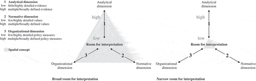
In this paper we are particularly interested in how this room is shaped so that it favours operational decision-making or collaboration and governance. To contribute to such sophisticated understanding we must first distinguish different dimensions of spatial concepts. Drawing from sources that discuss the use of geographic representation (Dühr, Citation2006), and spatial concepts in planning (Davoudi, Citation2003; Förster, Citation2009; Van Duinen, Citation2004; Zonneveld, Citation1991), we differentiate three dimensions: 1) Analytical dimension, where spatial concepts incorporate assumptions on the manner in which unplanned and unintended individual action affects spatial development. They provide a reservoir of analytical knowledge, which can be theoretically or empirically grounded. 2) Normative dimension, where spatial concepts are imaginations of desirable spatial development. They incorporate political values. 3) Organizational dimension, where spatial concepts indicate territories, areas wherein distinct policy measures take effect (for this definition of the term territory, see Schön, Citation2005). These three dimensions allow for a synthesis of analytical knowledge, political agendas, and policies and the constitution of spatial-planning rationales. To give an example: the Randstad concept relied on an observation of cities grouped around an open area. This observation turned into an imagination of a ring of cities around a green heart, motivated by a desire for spatial quality and healthy living environments, thus associating analytical knowledge with a political agenda. When the concept entered the realm of planning in the 1950s it was coupled with restrictive and prohibitive regulations, in what became the green heart territory.
Depending on the selection and detailing of all three dimensions, there is a certain amount of room for interpretation, as we have argued above. Actors and stakeholders are drawn in, or – alternatively – excluded. We illustrate this in . The diagram on the left represents a spatial concept with ample room for interpretation: one that implies multiple and broadly defined knowledge, agendas, and policy measures. This is in contrast to the diagram on the right, which symbolizes a spatial concept with narrow room for interpretation; one that implies few and highly detailed analytical notions, agendas, and policy measures. The model assesses the degree of room for interpretation as well as how this room is modified to favour operational decision-making or deliberation and governance.
Figure 1. Imaging room for interpretation.
After explaining our theoretical argument and analytical framework, we now turn to our empirical approach. An important way of identifying spatial concepts is to analyse planning imagery (for the appropriateness of this form of policy analysis, see Dühr, Citation2005). We therefore first considered the core maps of consecutive Dutch national plans. Textual phrases mentioned in the keys of these maps provided the codes of a follow-up in-depth text analysis. Our focus was on the text contained within the national plans. In cases where this included references to other documents, these became part of our review. Dutch national plans usually refer to a set of planning issues: urbanization, infrastructure development, the development of natural landscapes and rural land, and water management. Motivated by emphasis on collaboration in national urbanization policies, we have focused on concepts that specifically address this issue, including concepts that set out interrelations between the development of urban and open land, and between urbanization and transport infrastructure development. Concepts concerning transnational spatial development, such as international urban networks and foreign economic core areas, were excluded.
To assess the ambiguity of dimensions of spatial concepts, we were particularly interested in notions related to three implied items 1) analytical knowledge; 2) political values; and 3) policy measures in specific territories. Few and highly detailed notions on knowledge, values, and measures were equated with a high selectivity and a narrowly defined room for interpretation; a multiplicity of diverse and abstract notions were equated with high ambiguity and a broadly defined room. The results gave us an impression of how the room for interpretation that spatial concepts provided was shaped. A summary of results gave us an impression of how this room for interpretation has changed over time. To support our findings, as well as our preposition on governance responses to planning guidance, we made a comprehensive review of the academic literature on Dutch spatial planning, spatial concepts, and governance in the chosen time period.
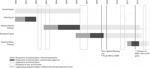
shows the national plans that were analysed. On the timeline a distinction is made between the informal preparation of plans (grey), the period of their approval by Parliament (dark grey), and the period of their application (light grey). We were interested in assented national plans – meaning plans that were approved during the legally required procedures and consequently replaced their predecessors (between 1988 and 2012 there were three such plans). Because we are interested in the subtle differences between planning rationales, we also considered two additional national plans. Around 2000, the government embarked on preparing a new (fifth) national plan and presented a draft version to the Parliament in 2002. We considered this draft plan, although it never came into effect. The Randstad Urgent program, presented in 2007, was an addition to the National Spatial Strategy. The Structural Vision Randstad 2040, a part of the program, was subjected to obligatory procedures required for national plans. We considered this plan as well, although it was simply a refinement of the – by then – current national plan. shows that national plans were subject to near constant revision during this period of considerable political instability in the Netherlands. The lightly dotted columns mark the formation of new coalition governments after the frequent national elections. The darker dotted lines concern important legal and procedural changes in Dutch national planning. We will return to these when discussing the various national plans.
Figure 2. Preparation of Dutch national plans, 2000–2012.
Below we present our analysis of spatial concepts in the consecutive plans. In the text we describe the main differences in the ambiguity of their dimensions. In the tables we list concepts and a summary of the analytical knowledge, political agendas, and policy measures they implied.
Room for Interpretation in Recent Dutch National Plans
The Fourth Report, 1988: A Starting Point for Analyses
In the late 1980s, a change in Dutch national spatial planning set in. Under the influence of European market integration, a process of regionalisation took off, shifting attention from national to regional planning territories and towards the economic competitiveness of regions in an international setting. The Fourth Report on Spatial Planning, published in 1988 (Ministerie van VROM, Citation1988), was the first Dutch national plan that reflected this change (Hajer & Zonneveld, Citation2000; Waterhout, Othengrafen, & Sykes, Citation2012; Zonneveld, Citation1991), albeit in a careful manner.
The Fourth Report sustained earlier planning rationales, institutionalised over decades of use. To distinguish open and rural land for the purpose of spatial quality, spatial diversity and liveability remained an important overarching spatial logic. Related concepts, combined under the heading “spatial main structure”, associated the rationale with an increasingly rigid regime of restrictive and prohibitive land-use regulation. In this sense, what Faludi & van Der Valk (Citation1994) called the Dutch planning doctrine was continued, but with a loss of some of its interpretative openness (Hajer & Zonneveld, Citation2000). To the refined doctrine, a new “master frame” was added (id., p. 341). The spatial concepts bundled in this overarching conceptual frame referred to a new political agenda: international economic competitiveness. They introduced analytical knowledge on relations between economic functions in regions from the field of economic geography. They also sketched the first contours of a new planning approach favouring investment in particular development projects over land-use designation and regulation (Hajer & Zonneveld, Citation2000). Under the heading “spatial development perspective”, new spatial concepts were used to justify direct investment in main transport axes, urban nodes, and, most prominently, main ports. The seaport Rotterdam and the airport Schiphol were seen as centres in large, international economic networks (for an analysis of the establishment of the main port concept, see Van Duinen, Citation2013).
In the Fourth Report, consolidated and emerging planning rationales were carefully placed next to each other. New spatial concepts that favoured a relational understanding of regional spatial development, an economic agenda, and strategic investment in particular areas appeared at the side of traditionally used concepts that favoured a morphological understanding of space, spatial quality and equality, and generally applicable regulation. The overall result (outlined in ) was an expanded array of planning rationales and thus broader room for interpretation. Nevertheless, the national plan caused unease among planners, particularly at sub-national government level. The tight selection of highly detailed policy measures was seen as an arbitrary choice in light of the broader body of analytical knowledge and political goals. The fact that these measures were decided upon during intra-governmental negotiations among ministries, with the inclusion of a limited number of corporatist organizations behind “closed doors”, fuelled criticism (Hajer & Zonneveld, Citation2000, p. 340). From the mid-1990s onward, coalitions of sub-national governments gathered to actively question the paternalistic role of the national government. They started to use the expanded repertoires of knowledge and goals in the national plan to point at regional development of national importance in their own territories (see, for instance, Van Duinen, Citation2015).
Table 1. Dimensions of spatial concepts in Fourth Report on Spatial Planning, 1988a.
By 1997 the disquiet had grown to such an extent that the government responded to it by considering preparing a new national plan. In 1998, a highly influential advisory on these proceedings was published by the Netherlands Scientific Council for Government Policy (NSCGP, Citation1999). It uncovered a mismatch between autonomous regional spatial development and ordering by the national government. Generally applicable regulation was seen to neglect specificities in regionalization, delay decision-making, obstruct the integration of sectoral policies, and lead to unfair distribution of the costs and benefits of national planning across areas and actors. An approach that imposed such regulation was also seen as failing to comply with the increasing engagement of others in planning, “reflexive governance” (id., p. 77) and, therefore obstructed the legitimization of planning.
At the core of the Council’s advice was a call for a more flexible national plan that facilitates deliberation and collaboration. The necessity of conceptual modernization for these purposes was underlined. Spatial concepts based on a generic spatial logic – prescribing planning for the entire country – were to be replaced by concepts that facilitated regionally differentiated approaches and a better-justified strategic engagement of the national government therein. New spatial concepts were to become “open” and “argumentative” (id., p. 80) to encourage deliberation. They were to enable “exploratory design” (id., p. 81), a collaborative search for planning solutions on the regional level. The wish list for revisions of concepts and their implied planning rationales was long (for a review of the advisory, see Hajer & Zonneveld, Citation2000). As we will show in the following sections, the upcoming national plans responded in different ways.
The Fifth Report, 2002: A Call for Voluntary Engagement in Planning
In 2001, a first draft version of the Fifth Report on Spatial Planning was published by the Ministry of Housing, Spatial Planning and the Environment (VROM) (Ministerie van VROM, & Rijksplanologische Dienst, Citation2001), and, in 2002, a second draft received ministerial approval (Ministerie van VROM, & Rijksplanologische Dienst, Citation2002). In terms of how the normative dimension of spatial concepts in this national plan has taken shape, the difference with the previous plan is not so very large: to improve the international economic competitiveness of the country and to guarantee spatial quality (this time set out in a comprehensive list of seven sub-qualities), remained both prime goals. However, the manner in which a broad agenda was interwoven with analytical knowledge about spatial development and policies deviated quite heavily from the Fourth Report.
First of all, the analytical foundation of national spatial planning was expanded and knowledge became less instrumentally tied-in with particular spatial concepts. This is apparent when one looks at the new conceptualisation of a “national spatial main structure” in the Fifth Report. The structure consisted of three layers, capturing characteristics of soil and natural landscapes, main infrastructure, and urban occupation. An extensive body of analytical knowledge on how these structural characteristics (were likely to) change and influence each other served as an inspirational background for more operational concepts. Some of these concepts emphasized particular knowledge. A strict morphological differentiation between natural landscapes and urban land continued to facilitate prohibitive land-use regulation in national parks, for instance. However, most concepts associated with the body of knowledge (a “frame of reference” in the words of Ministerie van VROM, & Rijksplanologische Dienst (Citation2001, p. 139)) referred to multiple interaction between layers, thus breaking open divisions between disciplinary knowledge and policy sectors. Specifically, the perception of urbanization was altered drastically when compared with its predecessor. Concepts promoting solitary compact cities were abandoned and replaced with the urban network concept. The concept, deliberately adopted from the European planning discourse (id., p. 148 and 179), referred to both a relational and morphological understanding of spatial development. It also referred to a long list of political values, including spatial quality, spatial diversity, social vitality, and economic competitiveness. Urban networks were seen to function on a higher level of scale and their planning was to involve sub-national government.
This brings us to the second main difference between the Fourth and Fifth Reports: the more ambiguous organizational dimension of spatial concepts. Overall, the new national plan placed far less emphasis on regulations (in particular those of urban land-use). Many were dropped or weakened. For instance, the concept of red contours was used to confine the expansion of cities but their future perimeter was no longer to be imposed but only suggested by provinces and municipalities. The most important change was in the organizational dimension of the urban-network concept. As in the Fourth Report, a set of strategic investment projects was defined on the grounds of perceived functional relations between cities. The assumption that the economic fortune of the country is highly dependent on its two main ports was almost totally erased. Instead, the station areas in the four main Delta Metropolis cities – this new metaphor for the Randstad area was chosen to underline that the traditional green/red dichotomy had become obsolete – plus Arnhem and Breda were assigned key project status. Additionally, the national government opened up discussion on a new generation of such projects. Guided by multiple theories and the observation that the layered “national spatial main structure” implied and further stimulated by regional development funding programs, sub-national governments in the indicated urban-network territories were asked to co-operate, create proposals for regional projects and strategies, and inform national planning in this way.
The Fifth Report on Spatial Planning was the first Dutch national plan that explicitly mentioned the decentralization of planning tasks in the Netherlands. The slogan “decentralize when possible, centralize when necessary” (id., p. 266) underlined the fact that the planning principles incorporated in the document were shaped carefully to maximize collaboration between tiers of government. A broad national planning agenda was sustained. The description of the main spatial structure provided a comprehensive knowledge background, reflected in the atlas-like appearance of the first draft of the national plan, a massive hardback of over 200 pages, with dozens of maps and illustrations in its first chapters. In line with the 1998 advisory note by the Netherlands Scientific Council for Government Policy, spatial concepts (outlined in ) were not intended to prescribe regional planning in detail but to facilitate deliberation. Specifically the concept urban networks was a call for voluntary engagement of sub-national governments in national spatial planning. The national plan inspired intense experimentation and co-operation among regional actors in the following years. Exploratory (regional) design became a common practice: many initiatives engaged in a search for arguments to fill the organizational void that the government has deliberately sought to create and was asked by many to do so (Hajer & Zonneveld, Citation2000; Lambregts, Janssen-Jansen, & Haran, Citation2008; Salet, Citation2006).
Table 2. Dimensions of spatial concepts in Fifth Report on Spatial Planning, 2002.
National Spatial Strategy, 2006: A Turn Towards Pragmatic Behaviour
Although the Fifth Report on Spatial Planning had the impacts just highlighted, it never became an effective national plan because in April 2002 the Dutch coalition government collapsed before reaching the end of its period in office. In November 2002 a new government, now led by Christian Democrats, announced the making of a revised version of the report. The objectives of the revision were to further advance decentralization and deregulation and to simplify the national policy system by integrating national sector policies in one overall strategy (Vink & Van Der Burg, Citation2006).
To this end, several ministries formulated their own ideas about spatial planning (with a delay caused by another fall of government in 2003 and the formation of a new one, still led by Christian Democrats). In July 2004, the Ministry of Economic Affairs (EZ) published the report Peaks in the Delta (Ministerie van EZ, Citation2004). As the title suggests, the Ministry favoured planning engagement in economically well-performing areas to accelerate international competitiveness. According to the Ministry, this rationale had a strong empirical evidence base: research showed that internationally operating economic sectors are clustered in economic core areas, mostly located in the sphere of influence of major transport axes. The main port concept was prominently reinserted into the discourse and the port metaphor was expanded to also include brain ports (areas with a concentration of knowledge-intensive economic activities) and green ports (areas with a concentration of intensive agriculture production and greenhouses).
Within the Ministry of Transport and Water Management (V&W), the rationale that the Ministry of EZ was proposing did not fall on deaf ears: the importance attached to transport infrastructure underlined its politics. The Ministry’s support for the (re-affirmed) concepts was included in the Mobility Report (Ministeries van V&W, & VROM, Citation2004), a joint production of the V&W and the VROM Ministry. International economic competitiveness and “reliable transport” (meaning transport that is not hindered by congestion) were two of the prime objectives in this document. The combination of agendas was facilitated through a rather straightforward cartographic exercise: the map of economic core areas, prepared by the Ministry of EZ, was overlaid with a map of main transport lines. This led to the selection of a limited number of main transport axes as well as to priorities in the improvement of these.
The new concepts were combined with those of the draft Fifth Report by the Ministry of VROM and the resulting scheme was presented as the final version of this national plan in 2006, albeit with the new name National Spatial Strategy (Ministeries van VROM, LNV, V&W, & EZ, Citation2006). The way in which it was prepared is reflected in its list of authors: for the first time, a national plan was not written and published solely by the Ministry of VROM, but by the above-mentioned Ministries of EZ and V&W also. The new “national spatial main structure” in the plan consisted of a complex mixture of the concepts that these Ministries had promoted: economic core-areas and ports (entries of the Ministry of EZ), main transport axes (entry of the Ministry of V&W) overlapped with urban networks (entry of the Ministry of VROM, adopted from the Fifth Report). The national urban network Randstad Holland (in the Fifth Report called Delta Metropolis) was, for instance, intersected with three economic core areas (the Utrecht region, a North wing and a South wing) and six ports.
The map of the national spatial main structure represented the different spatial concepts and their related territories as softly sketched clouds. However, concepts were far less ambiguous than their spatial representation suggested. Specifically, their organizational dimension was refined thoroughly and selectively. The principle of refinement was a distinction between two categories of national planning responsibility, a “responsibility for the system” and a “responsibility for results” (id., p. 25). The former meant that the national government provides procedural support in such a way that others, such as provinces, municipalities, and private-sector actors, can act out their roles in regional policy-making appropriately. The latter meant that the government is fully responsible for the outcomes of policies, predominately consisting of direct investment in key projects, area development, and transport infrastructure. The distribution of concepts across these two categories became a highly sensitive political issue, as we shall see.
Although the afore-mentioned economic-leaning concepts were directly related to the government’s responsibility for results, the urban-network concept, whose normative dimension included economic competitiveness, was not accounted for. From the 17 national and regional urban networks of the Fifth Report, the National Spatial Strategy sustained only the six national ones, and these were associated with national responsibility for the system. Once more the central government used the concept to call for voluntary engagement of sub-national governments in the planning of the urban-network territories but engagement now became less rewarding in financial terms (few regional development funding programs were prolonged) and more regulated in procedural terms. It was indicated who was to become involved in urban-network partnerships (provinces were to take a leading role, for instance) and agreement among sub-national governments on particular issues (e.g. the distribution of new houses) was made a condition for national support. The national government increasingly served as a court of appeal, approving or rejecting project proposals. However, an association of the urban network concept with “responsibility for the system” implied that interpretations were not assessed on a spatial logic anymore (their reference to the broad body of analytical knowledge about spatial development and political values that the concept still incorporated) but on their compliance with procedural requirements mainly (for an outline description of concepts in the National Spatial Strategy, see ).
Table 3. Dimensions of spatial concepts in National Spatial Strategy, 2006.
A diminishing interest in collaborative spatial planning was expressed in the revision of the urban network concept. It was also reflected in the way in which “spatial quality” was conceptually accommodated. Creating and preserving such quality across the country remained an objective of national spatial planning, but the agenda was refined and associated with additional divisions of responsibilities. In the Fifth Report, a variety of spatial qualities was seen to emerge from an intricate interplay among structural spatial characteristics. The new strategy was much more modest in this respect. Now, the central government only felt responsible for a “basic spatial quality” (id., p. 25). For the national core planning territories, few desirable outcomes from interaction between layers were selected for the assessment of project proposals by sub-national governments. For areas beyond these territories three standards were defined: 1) basic legal quality defined by environmental law; 2) procedural quality embodied in obligatory environmental-assessment procedures; and 3) financial quality, to prevent the transfer of negative consequences of development to others. Besides implicitly questioning the political relevance of most of the concepts in the Fifth report, this revision had explicit consequences for concepts perpetuating the urban/rural dichotomy in the periphery of economic agglomeration. They were sustained but deliberation beyond legal dispute was devolved to sub-national governments.
To sum up: the National Spatial Strategy was a revision of the Fifth Report on Spatial Planning by a new government with a new political colour. New concepts rationalizing a select choice of direct investment in infrastructure and economic development were added. In the revision of earlier concepts, a highly pragmatic approach was employed. Their array of political values was kept intact, as well as their broad analytical foundation. The main changes concerned the organizational dimension of these concepts: they were detached from a direct national responsibility for outcomes. From a decentralization perspective, this retreat of the national government appears to be a sound development. In terms of public finance, the picture is different, however. In the Netherlands, more than 95% of taxes are collected centrally (OECD, Citation2014). The national government’s focus on investment in (infrastructure) projects perpetuates the dependency of sub-national governments on the national one, as observed by Salet (Citation2006, p. 975): “Coalitions at all levels lobby for infrastructural interconnections within the various territorial scales and all know that, in the coming 15 years, only one such major investment has a chance of becoming reality. Governance coalitions turn out to be ruled by pragmatic and opportunistic sets of options rather than by coherent action strategies.”
Randstad 2040 and Randstad Urgent, 2008: Two Types of Planning Spaces
The manner in which the national government allocates taxpayers’ money to spatial projects became a sensitive political issue (this was already the case even before the National Spatial Strategy was assented to). In March 2005, concern about weakly underpinned investment decisions found an expression in a Parliamentary resolution calling for improved justification through long-term strategic planning (Eerste Kamer der Staten-Generaal, Citation2005) . Owing to another collapse of government in July 2006, a response to the resolution was substantially delayed. It was not until February 2007 that a new government, still led by Christian Democrats, announced 1) a reform of the process protocol for the allocation of infrastructure funds and 2) a new planning framework confined spatially to the Randstad region (for an advisory report on this matter, see OECD, Citation2007) .
The first issue, the reform of infrastructure funding allocation, took shape through a profound change in the Long-Term Program for Infrastructure and Transportation (MIT) in 2008. The highly regulated procedure for investment in infrastructure from this moment on would be accompanied by considerations about the impact of spending on spatial development. MIT became MIRT where the R stands for “space” (ruimte in Dutch) (for a review of this change, see Zonneveld & Spaans, Citation2014).
The manner in which the second issue was taken up needs some explanation. The Ministry of V&W was struggling with delays in the implementation of projects, supposedly due to administrative fragmentation. Delays were seen to be specifically problematic for the development of the Randstad area, economically the country’s most important region. To counteract fragmentation, the Ministry established the Randstad Urgency program. Its main intention was to prioritize projects from the many proposals that crowded the Ministry’s project books since claiming infrastructure funds became a common form of inter-governmental collaboration (for an analysis of the program, see Busscher, Tillema, & Arts, Citation2013). The Ministry of VROM – possibly fearing being side-tracked – inserted a particular project into this program: the Structural Vision Randstad 2040 was to establish guiding principles for long-term spatial planning and in this way influence future planning decisions (Ministerie van VROM, Citation2008).
The spatial concepts that the Ministry of VROM incorporated in this vision (outlined in ) reiterated many of the rationales of national spatial planning since the late 1980s. Concepts, most prominently the concept metropolitan parks, enriched the green-belt vocabulary, under the heading “interaction between green, blue and red”. Concepts such as urban region revived compact city rationales. To enhance regional accessibility, the vision borrowed the analytical concept of daily urban systems from economic geography. On the grounds of empirical knowledge about travel patterns and business relations, it was concluded that the Randstad was composed of two such urban regions: a Southern and a Northern Randstad, thus confirming the earlier defined economic core areas. To “strengthen what is internationally strong” it advocated six economic top functions in the region (the former main and green ports were among them). The development of main transport axes was to improve the external accessibility of the Randstad.
Table 4. Dimensions of spatial concepts in Structural Vision Randstad 2040, 2008.
The Structural Vision Randstad 2040 is the first formally approved Dutch national plan dedicated to the west of the country. Because of this focus, it was able to set out the many spatial concepts it incorporated with a relatively high degree of detail. Each concept implied a cluster of political goals linking environmental sustainability (climate-change resilience in particular), spatial quality, social vitality, and economic competitiveness in intricate ways. Moreover, the makers of Randstad 2040 could rely heavily on prior empirical knowledge, as the ample references to extant research show. Earlier studies and advisory reports, accomplished for a variety of purposes, were re-used to create a broad yet detailed reference base of concepts. However, the organizational dimension of the concepts – their implied policy measures – remained largely undefined. Concepts were associated with few ongoing policies and projects of national importance, that were, in the main, the responsibilities of the Ministries of V&W and EZ. Most were associated with a need for further elaboration in terms of research as well as collaboration. To structure future partnerships, the vision identified several types of “societal alliances”. Actors from public, private, and civil domains were asked to become voluntarily involved in the planning of the Randstad region for the benefit of “people, planet and profit” (id., p. 15).
As noted above, the Structural Vision Randstad 2040 was part of the Randstad Urgent program. While the Ministry of VROM designed its long-term planning guidance, the Ministry of V&W continued to select projects of national importance to be funded in the near future. The Randstad Urgency program, including the Vision, did not substitute the National Spatial Strategy; the program was only meant to operationalize the national plan. From the perspective of conceptual reform, however, it issued an important signal. It accelerated the distinction between two types of national-planning responsibility that the National Spatial Strategy had introduced, and illustrated what this meant for decision-making. On the one side, the Ministry of V&W created a list of stand-alone projects with little common argument (Busscher et al., Citation2013), and then moved them under the purview of the highly regulated MIRT program. Conceptual underpinning (justification by means of a spatial logic) was deemed unnecessary. On the other, the Ministry of VROM engaged in intense public debate on appropriate spatial planning (for a review, see Blank et al., Citation2009). Almost the entire body of previously used spatial concepts, including their repertoires of analytical knowledge and political values, was activated for this purpose. It was shown that “responsibility for the system” implies intense reflection on multiple interwoven planning rationales. However, it was also shown that no concrete policy action was attached to such reflection. Room for interpretation was sustained but had become impractical.
National Policy Strategy, 2012: One Imperative Plan
The long-term Structural Vision Randstad 2040 had a very short life. In July 2008, a new Dutch Spatial Planning Act, under Parliamentary review since 2002, became effective. This new law upheld the role of national plans in Dutch planning but made them less dominant. For the purpose of subsidiarity it required not only the national government but provincial and municipal governments as well to present structural visions which were then made self-binding (Buitelaar, Citation2010).
The enforcement of the Act obliged the national government to publish a new national plan. It responded to this obligation, albeit with some delay. The crisis in financial markets and another fall of government slowed down delivery. A new government, now led by centre-right Liberals, was only formed in October 2010. The first action of this new government was to organize itself more efficiently, and for this purpose the two Ministries of VROM and V&W were merged into one: the Ministry of Infrastructure and the Environment (I&M). In September 2011 the first draft of the National Policy Strategy for Infrastructure and Spatial Planning was published, and in March 2012 the final version substituting the National Spatial Strategy and the Structural Vision Randstad 2040 became effective (Ministerie van I&M, Citation2012).
Similar to earlier national plans, the National Policy Strategy introduced a “national spatial main structure”, bundling spatial concepts into one overarching framework. The structure incorporated a number of urban regions with a concentration of top sectors, geographically resembling the economic core areas that the Ministry of EZ had introduced in 2004. Their boundaries (“elastics”, as they were called in the hallways of the Ministry of I&M at that time) circumscribed locations of economic activities (top sectors) whose development was to foster the country’s international economic competitiveness. To the selection of sectors in the Structural Vision Randstad 2040, ten new ones were added. Analytically the top sector concept relied on knowledge about system innovation and the development of international markets (HCSS, & TNO, Citation2011). In its organizational dimension it was associated with integrated area development in few priority areas and relied largely on non-spatial policies, such as tax incentives, trade agreements, and investment in research and development (Ministeries van EZ, Financiën, OCW, Citation2011) . Under the heading “possible new connection in the main transport network” accessibility became a more independent agenda in comparison with earlier national plans because it was equated with reliable transport and effortless travel for transport users only. The impact of transport development on urbanization found little consideration. A detailed analytical model to measure the cost of travel was introduced. It became the most important instrument in identifying a need for investment into new transport infrastructure.
As Waterhout et al. (Citation2012, p. 6) noted, when the “neo-liberal minority coalition took office in 2010, everything pointed towards a complete abolition of planning at the national level. (S)patial planning in all its manifestations, even when it aims to facilitate economic development, is judged a hindrance for the freedom of individuals and companies.” This observation is confirmed by our review of spatial concepts incorporated in the National Policy Strategy (outlined in ); the plan was indeed stripped of most of the spatial logics that had guided earlier Dutch national planning. The national government was to act only if national interests were at stake, and these interests have been kept to a bare minimum. Where the plan remained to have spatial implication, argumentation was confined by highly detailed policy measures. Objectives (e.g. the preservation of cultural heritage) were linked to existing (mostly European) law and regulation, further removing planning decision-making from the site of informal negotiation among governments to the site of courts and administrations. Planning decision-making on integrated area development (predominantly invoked by investment into transport infrastructure) was moved under the MIRT program, whose procedures had become more detailed in January 2009. Involving stakeholders, sub-national governments among them, became mandatory during early decision-making stages. Involvement was to identify any potential conflict around national projects early and in this way accelerate the speed of implementation. A room for interpretation was sustained in this way. However, it allowed for discussing options in transport development only.
Table 5. Dimensions of spatial concepts in National Policy Strategy, 2012.
Discussion
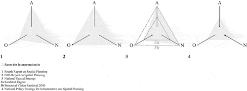
The 2012 National Policy Strategy is acknowledged as having been a stark move in Dutch planning, from indicative to imperative, and to represent a break in a long tradition of collaborative planning decision-making (Needham, Citation2015; Waterhout et al., Citation2012). Our review of the differences in the ambiguity of dimensions of spatial concepts (summarized in below) led us to a detailed reading of this move.
Table 6. Room for interpretation in Dutch national plans, 1988–2012.
The ongoing liberalization of European markets caused an increase of attention to economic competitiveness in an international setting in Dutch national planning in the late 1980s. To facilitate this, new spatial concepts were added to ones that had been consolidated over a decade of use. The new concepts were first used to prioritize investment in few priority areas. In the context of a broadened normative and analytical scope of planning, however, these straightforward operational decisions elicited criticism from planners. Discontent about weakly justified national spatial selectivity grew into a call for conceptual modernization in the late 1990s. A new generation of spatial concepts was to enhance regionally differentiated planning approaches and strategic engagement of the national government therein. The new concepts were also meant to be ‘argumentative’, so as to not prescribe regional planning precisely but to be more open to interpretation and support collaboration among the various tiers of government in this way.
With hindsight, what looked like an experimental phase, an overly frequent publication of national plans has occurred since 2000. One observation drawn from our analysis of these plans is the gradual shrinkage of room for interpretation that conceptual reform implemented. When focusing on dimensions of spatial concepts, stages in confinement can be distinguished (see ). During a first stage, room for interpretation increased substantially. In particular the urban network concept, taken up in the 2002 Fifth Report, implied a broad political agenda, a fuzzy landscape of analytical knowledge about spatial development, and a multitude of divers and ambiguous policy measures. Sub-national governments in “soft” territories were to use these repertoires to formulate projects and strategies of national importance on their own initiative. During a second stage, new concepts were added while earlier ones were retained. It seemed that the 2006 National Spatial Strategy opened up an even broader room for interpretation. However, the organizational dimension of the concepts was selectively revised. Some concepts remained ambiguous in this dimension, continuing deliberation about what national planning guidance means when applied to particular regions. Others were firmly associated with projects of definite national importance. The distinction between concepts by their organisational implications was accelerated by the 2008 Randstad Urgent program. The core program focused on the implementation of infrastructure projects. The Structural Vision 2040, possibly in itself a critique on the emerging form of infrastructure planning, revived a multitude of concepts. In conjunction, these expanded room for interpretation once more. However, in their organizational dimension, the concepts were associated with continuing research and argumentation, nothing more. Spatial planning was rendered as a discussion on the distant future with no concrete action to be attached to it. During a third stage, this argumentative branch of planning was simply dropped. What remained was an inflexible, imperative planning scheme underpinned by largely non-spatial rationales and with very little room for interpretation.
Figure 3. Dimensions of spatial concepts in Dutch national plans, 1988–2012.
Our observations raise some points for discussion. First of all, they allow us to argue that the transformation of spatial planning rationales in Dutch national planning over the time period was mainly facilitated by pragmatic behaviour. When considering the political agendas and the analytical knowledge that spatial concepts incorporated, there was relative stability up until 2012. Changes in the room for interpretation were, above all, implemented through a re-coupling of these ambiguous repertoires with increasingly detailed policy measures in ever more confined territories. One explanation of this development is an interest in decentralization (formalised in the 2008 new Spatial Planning Act). However, change had implications beyond the devolution of responsibilities. As our analysis reveals, the re-coupling worked in parallel with favouring a distinct normative agenda (international economic competitiveness). In this sense, the gradual migration of room for interpretation from the national to the lower levels of government was politically selective. Also, the growing dominance of a distinct form of planning (“infrastructure planning”) cannot be fully explained by the benefits of decentralization. Last but not least, our results show changing preferences for forms of decentralization. Over time, dimensions of spatial concepts were shaped to favour a form in which governmental tiers each focussed on their own, select spatial planning rationales over a form in which tiers engage in deliberation on the implications that shared rationales can have when applied to particular regions and places.
Conclusions
In this paper we have argued that spatial concepts are discursive structures that allow for the construction of planning rationales by incorporating analytical, normative, and organizational dimensions. Based on notions of the importance of choice in argumentative planning practices, we were particularly interested in the selection and detailing of these dimensions assuming that their ambiguity shapes room for interpretation and thus collaboration and governance.
There are no proven measurements of the ambiguity of spatial concepts. We needed to rely on rough estimations of change in their repertoires of analytical knowledge about spatial development, political agendas, and policy measures. We underpinned our proposition that room for interpretation shapes governance responses theoretically. In our empirical analysis we mentioned responses where literature on Dutch planning provided insights. A consistent empirical tracing of responses would have gone far beyond the scope of this paper. Despite limitations, our analysis does allow for conclusions concerning our theoretical ambition: a more detailed understanding of the use of ambiguous (“fuzzy” or “soft”) geographic perceptions in the realm of spatial planning.
Our exploration allows us to argue that the dimensions of concepts that we distinguish gained attention in the formulation of planning guidance; that they were used to practice planning control. While spatial concepts were sustained as metaphorical entities, their analytical, normative, and organizational dimensions were (re-)considered apart. Revision appears as a careful crafting of conditions for discretion: concepts were shaped to not just operationalize planning guidance, but also to foster or restrict deliberation on the implications that guidance has when applied to particular spatial situations. “Soft” planning frameworks are associated with a variety of governance responses, as we noted in our introduction. Our detailed tracing of how conflicting desires for spatial selectivity and ambiguity are accommodated inside geographic perceptions indicates that these responses are foreseen and are built into the spatial imaginaries used in the realm of spatial planning.
In applying our analytical framework to the Dutch case, we recognized the importance of sudden political and organizational changes, for instance, in the form of a new government with a different political colour, as well as legal and procedural change. Nevertheless, across these events we noticed a faint but discernible logic that explains the consecutive revisions of national plans by an enduring attempt to couple a preferred political agenda with a selected form of policy-making. This logic became apparent through assuming that spatial concepts allow for the construction of planning rationales because they are composed of an analytical, normative, and organizational dimension. In this context, the transformation of concepts appears as an assemblage, a process of association of these dimensions of geographic perceptions, perpetuated by their ambiguity.
We do not suggest that such assemblage ended in 2012 in the Netherlands. A new Dutch national plan, replacing the National Policy Strategy, was due to be published while this paper was being written (Ministerie van I&M, Citation2017). Objectives set out for the National Environmental Planning Strategy are ambitious, as is often the case at the beginning of a new round of national plan-making in the Netherlands. The plan is supposed to integrate a greater variety of sectoral interests, revive collaboration among levels and tiers of government and civil society, and make planning rules (specifically those regarding environmental law) simpler and more effective. Discussion on how to combine a preference for detailed operational planning rationales with a desire for collaboration and governance seems to continue. From the perspective of our analytical framework such continuation is comprehensible. A spatial logic built into geographic perceptions cannot be ambiguous and select at the same time. To have spatial imaginaries support both broadly agreed-upon and effective planning requires reflexivity: continuing deliberation on how implied general planning rationales relate to problems in particular local situations and vice versa.
Disclosure statement
The authors received no financial support for the research, authorship, and/or publication of this article.
Additional information
Notes on contributors
Verena Balz
Verena Elisabeth Balz is assistant professor and Wil Zonneveld is professor of Urban and Regional Planning, both at the Faculty of Architecture and the Built Environment, Department of Urbanism at the Delft University of Technology, the Netherlands.
References
- Albrechts, L. (2004). Strategic (spatial) planning reexamined. Environment and Planning B, 31, 743–758.
- Albrechts, L., Healey, P., & Kunzmann, K. R. (2003). Strategic spatial planning and regional governance in Europe. Journal of the American Planning Association, 69(2), 113–129.
- Alexander, E. (2002). Metropolitan regional planning in Amsterdam: A case study. Town Planning Review, 73(1), 17–40.
- Allmendinger, P., & Haughton, G. (2010). Spatial planning, devolution, and new planning spaces. Environment and Planning C: Government and Policy, 28(5), 803–818.
- Allmendinger, P., & Haughton, G. (2012). Post-political spatial planning in England: A crisis of consensus? Transactions of the Institute of British Geographers, 37(1), 89–103.
- Allmendinger, P., Haughton, G., & Shepherd, E. (2016). Where is planning to be found? Material practices and the multiple spaces of planning. Environment and Planning C: Government and Policy, 34(1), 38–51.
- Blank, H., Van Boheemen, Y., Bouw, M., Brouwer, J., Feddes, Y., Van Hees, J., … Wierenga, E. (Eds.). (2009). Ontwerpen aan Randstad 2040/Designing Randstad 2040, Design and Politics #2 (Vol. 2). Rotterdam: Uitgeverij 010.
- Booth, P. (1996). Controlling development: Certainty and discretion in Europe, the USA and Hong Kong. London: UCL Press.
- Booth, P. (2007). The control of discretion: Planning and the common-law tradition. Planning Theory, 6(2), 127–145.
- Buitelaar, E. (2010). Windows on the Netherlands, cracks in the myth: Challanges to land policy in the Netherlands. Tijdschrift Voor Economische En Sociale Geografie, 101(3), 349–356.
- Buitelaar, E., & Sorel, N. (2010). Between the rule of law and the quest for control: Legal certainty in the Dutch planning system. Land Use Policy, 27(3), 983–989.
- Busscher, T., Tillema, T., & Arts, J. (2013). Revisiting a programmatic planning approach: Managing linkages between transport and land use planning. Planning Theory & Practice, 14(4), 492–508.
- Davoudi, S. (2003). European briefing: Polycentricity in European spatial planning - from an analytical tool to a normative agenda. European Planning Studies, 11(8), 979–999.
- Davoudi, S., & Strange, I. (Eds.). (2008). Conceptions of space and place in strategic spatial planning. London and New York: Routledge.
- Dryzek, J. S. (1993). Policy analysis and planning: From science to argument. In F. Fischer & J. Forester (Eds.), The argumentative turn in policy analysis and planning (pp. 213–232). London: UCL Press.
- Dühr, S. (2005). Spatial policies for regional sustainable development: A comparison of graphic and textual representations in regional plans in England and Germany. Regional Studies, 39(9), 1167–1182.
- Dühr, S. (2006). The visual language of spatial planning: Exploring cartographic representations for spatial planning in Europe. London/New York: Routledge.
- Eerste Kamer der Staten-Generaal. (2005). Geïntegreerd beleidsdebat over de ruimtelijk-economische ontwikkeling in Nederland: Motie van het lid Lemstra C.S. [Debat about spatial-economic development in the Netherlands: Resolution Lemstra]. The Hague: Sdu Uitgevers.
- Faludi, A. (1987). A decision-centred view of environmental planning. Oxford: Pergamon.
- Faludi, A. (1996). Framing with images. Environment and Planning B: Planning and Design, 23(1), 93–108.
- Faludi, A. (2000). The performance of spatial planning. Planning Practice & Research, 15(4), 299–318.
- Faludi, A., & Korthals Altes, W. (1994). Evaluating communicative planning: A revised design for performance research. European Planning Studies, 2(4), 403–418.
- Faludi, A., & Van Der Valk, A. J. J. (1994). Rule and order: Dutch planning doctrine in the twentieth century. Dordrecht: Kluwer Academic Publishers.
- Förster, A. (2009). Visualisierungen in räumlichen Planungsprozessen - Über die Gleichzeitigkeit der Arbeitsebenen Analyse, Entwurf, Organisation und Politik [Visualisation in spatial planning - about the sychrony of working on analyses, design, organisation and politics]. Tagung Stadt als Erfahrungsraum der Politik des Arbeitskreises Politik und Kultur der DVPW, München.
- Friend, J., & Jessop, N. (1977). Local government and strategic choice. Oxford: Pergamon.
- Gualini, E., & Majoor, S. (2007). Innovative practices in large urban development projects: Conflicting frames in the quest for “new urbanity”. Planning Theory & Practice, 8(3), 297–318.
- Hagens, J. E. (2010). The performance of landscape concepts in spatial planning: Branding, bonding and bringing about. (Doctoral thesis), Wageningen University, Wageningen.
- Hajer, M., & Versteeg, W. (2005). A decade of discourse analysis of environmental politics: Achievements, challenges, perspectives. Journal of Environmental Policy & Planning, 7(3), 175–184.
- Hajer, M., & Zonneveld, W. (2000). Spatial planning in the network society: Rethinking the principles of planning in the Netherlands. European Planning Studies, 8(3), 337–355.
- HCSS, & TNO. (2011). Nederlands Concurrentievermogen en Mondiale Krachten: Een Eerste Verkenning van Topsectoren [Dutch Capacities for Concurrence and Mondial Forces: A First Inventory of Top Sectors]. The Hague: The Hague Centre for Strategic Studies (HCSS) and TNO.
- Healey, P. (2006). Relational complexity and the imaginative power of strategic spatial planning. European Planning Studies, 14(4), 525–546.
- Hincks, S., Deas, I., & Haughton, G. (2017). Real geographies, real economies and soft spatial imaginaries: Creating a ‘more than Manchester’ region. International Journal of Urban and Regional Research, 41(4), 642–657.
- Jessop, B. (2001). Institutional re(turns) and the strategic - relational approach. Environment and Planning A, 33(7), 1213–1235.
- Lambregts, B., Janssen-Jansen, L., & Haran, N. (2008). Effective governance for competitive regions in Europe: The difficult case of the Randstad. GeoJournal, 72, 45–57.
- Markusen, A. (1999). Fuzzy concepts, scanty evidence, policy distance: The case for rigour and policy relevance in critical regional studies. Regional Studies, 33(9), 869–884.
- Ministerie van EZ. (2004). Pieken in de Delta. Gebiedsgerichte Economische Perspectiefen [Peaks in the Delta. Economic Perspectives on Area Development]. The Hague: Ministerie van Economische Zaken (EZ).
- Ministerie van I&M. (2012). Structuurvisie Infrastructuur en Ruimte: Nederland Concurrerend, Bereikbaar, Leefbaar en Veilig [National Policy Strategy for Infrastructure and Spatial Planning]. The Hague: Ministerie van Infrastructuur en Milieu (I&M).
- Ministerie van I&M. (2017). De opgaven voor de Nationale Omgevingsvisie [Tasks for the National Environmental Planning Strategy]. The Hague: Ministerie van Infrastructuur en Milieu (I&M).
- Ministerie van VROM. (1988). Vierde Nota over de Ruimtelijke Ordening: Op Weg naar 2015. Deel d: Regeringsbeslissing [Fourth Report on Spatial Planning]. The Hague: SDU uitgeverij.
- Ministerie van VROM. (2008). Structuurvisie Randstad 2040. Naar een Duurzame en Concurrerende Europese Topregio. Zoals Vastgesteld in de Ministerraad van 5 september 2008 [Structural Vision Randstad 2040]. The Hague: Ministerie van Volkshuisvesting Ruimtelijke Ordening en Milieubeheer (VROM).
- Ministerie van VROM, & Rijksplanologische Dienst. (2001). Ruimte Maken, Ruimte Delen: Vijfde Nota over de Ruimtelijke Ordening 2000/2020. Vastgesteld door de Ministerraad op 15 December 2000 [Fifth Report on Spatial Planning]. The Hague: Ministerie van Volkshuisvesting Ruimtelijke Ordening en Milieubeheer (VROM).
- Ministerie van VROM, & Rijksplanologische Dienst. (2002). Ruimte Maken, Ruimte Delen. Vijfde Nota over de Ruimtelijke Ordening 2000/2020. PKB Deel 3, Kabinetsstandpunt [Fifth Report on Spatial Planning]. The Hague: Ministerie van Volkshuisvesting Ruimtelijke Ordening en Milieubeheer (VROM).
- Ministeries van EZ, Financiën, OCW. (2011). Naar de top. Het bedrijfsbeleid in actie(s) [To the top: Business policies in action(s)]. The Hague: Ministeries van Economische Zaken (EZ), Financiën & Onderwijs, Cultuur en Wetenschap (OCW).
- Ministeries van V&W, & VROM. (2004). Nota Mobiliteit: Naar een Betrouwbare en Voorspelbare Bereikbaarheid [Mobility Report: Towards Relyable and Predictable Accessibility]. Den Haag: Ministerie van Verkeer en Waterstaat (V&W) & Ministerie van Volkshuisvesting Ruimtelijke Ordening en Milieubeheer (VROM).
- Ministeries van VROM, LNV, V&W, & EZ. (2006). Nota Ruimte, Deel 4: Tekst naar parlamentaire instemming [National Spatial Strategy, after parliamentary approval]. The Hague: Ministeries van Volkshuisvesting Ruimtelijke Ordening en Milieubeheer (VROM), Landbouw Natuur en Voedselkwaliteit (LNV), Verkeer en Waterstaat (V&W) en Economische Zaken (EZ).
- Nadin, V. (2007). The emergence of the spatial planning approach in England. Planning Practice & Research, 22(1), 43–62.
- Needham, B. (1988). Continuity and change in Dutch planning theory. The Netherlands Journal of Housing and Environmental Research, 3(1), 5–22.
- Needham, B. (2015). The National Spatial Strategy for The Netherlands. In G.-J. Knaap, Z. Nedovic-Budic, & A. Carbonell (Eds.), Planning for States and Nation-States in the U.S. and Europe. Cambridge: Lincoln Institute of Land Policy.
- NSCGP. (1999). Spatial Development Policy. Summary of the 53rd Report. The Hague: Author.
- OECD. (2007). Territorial reviews: Randstad Holland, the Netherlands. Paris: OECD Publishing.
- OECD. (2014). Territorial reviews: Netherlands 2014. Paris: OECD Publishing.
- Roodbol-Mekkes, P. H., van Der Valk, A. J. J., & Korthals Altes, W. K. (2012). The Netherlands spatial planning doctrine in disarray in the 21st century. Environment and Planning A, 44(2), 377–395.
- Salet, W. (2006). Rescaling territorial governance in the Randstad Holland: The responsiveness of spatial and institutional strategies to changing socio-economic interactions. European Planning Studies, 14(7), 959–978.
- Salet, W., & Woltjer, J. (2009). New concepts of strategic spatial planning: Dilemmas in the Dutch Randstad region. International Journal of Public Sector Management, 22(3), 235–248.
- Schön, P. (2005). Territorial cohesion in Europe? Planning Theory & Practice, 6(3), 389–400.
- Tewdwr-Jones, M. (1999). Discretion, flexibility, and certainty in British planning: Emerging ideological conflicts and inherent political tensions. Journal of Planning Education and Research, 18(3), 244–256.
- Van Duinen, L. (2004). Planning Imagery. The Emergence and Development of New Planning Concepts in Dutch National Spatial Policy. ( Doctoral thesis), University of Amsterdam, Amsterdam.
- Van Duinen, L. (2013). Mainport and corridor: Exploring the mobilizing capacities of Dutch spatial concepts. Planning Theory & Practice, 14(2), 211–232.
- Van Duinen, L. (2015). New spatial concepts between innovation and lock-in: The case of the Dutch Deltametropolis. Planning Practice & Research, 30(5), 548–569.
- Vink, B., & van Der Burg, A. (2006). New Dutch spatial planning policy creates space for development. disP, 164(1), 41–49.
- Waterhout, B., Othengrafen, F., & Sykes, O. (2012). Neo-liberalization processes and spatial planning in France, Germany, and the Netherlands: An exploration. Planning Practice & Research, 28(1), 141–159.
- Zonneveld, W. (1989). Conceptual complexes and shifts in post-war urban planning in the Netherlands. Built Environment (1978-), 15(1), 40–48.
- Zonneveld, W. (1991). Conceptvorming in de Ruimtelijke Ordening: Patronen en Processen [Conceptualisation in Spatial Planning: Patterns and Processes]. ( Doctoral thesis), University of Amsterdam.
- Zonneveld, W. (2005). In search of conceptual modernization: The new Dutch ‘national spatial strategy’. Journal of Housing and the Built Environment, 20(4), 425–443.
- Zonneveld, W., & Spaans, M. (2014). Meta-governance and developing integrated territorial strategies: The case study of MIRT territorial agendas in the Randstad (Netherlands). Planning Theory & Practice, 15(4), 543–562.
- Zonneveld, W., & Verwest, F. (2005). Tussen Droom en Retoriek: De Conceptualisering van Ruimte in de Nederlandse Planning [Between Dream and Rhetorics: The Conceptualisation of Space in Dutch Planning]. Rotterdam: NAi Uitgevers.