
ABSTRACT
For three decades the case has been made for the development and adoption of digital tools that better support spatial decision-making in planning using 3D information. Here we report on a study that interviewed planners from local authorities in Ireland concerning their knowledge and experience of 3D spatial media. We consider the potential uses of these tools in planning, and the prospects for their adoption within local government planning departments. The interviews reveal that the planning system, as currently resourced and operated in Ireland, provides significant challenges and few incentives for the adoption of 3D spatial media.
Introduction
Planners and related professions (architects, surveyors, engineers) have long used a range of media to help them visualize, design, plan, model, simulate, assess, and promote their proposals for new developments. These include maps and site plans, cross-sections and elevations, perspective images, photomontages, panoramic views, and physical models (Doyle et al., Citation1998; Levy, Citation1995). Since the 1980s, the use of these media has been complemented by the introduction of increasingly sophisticated digital authoring tools and interaction technologies: Computer-Aided Design (CAD) (Al-Kodmany, Citation2002), 3D modeling packages (Schreyer, Citation2013), 3D GIS (Gu et al., Citation2011; Koninger & Bartel, Citation1998), virtual reality (VR) (Doyle et al., Citation1998; Portman et al., Citation2015; Salter et al., Citation2009), and augmented reality (AR) (Ghadirian & Bishop, Citation2008). Increasingly these technologies are converging in ways that support more integrated and iterative ways of working, enabled by the programmability of computational tools (Deutsch, Citation2017), and growing capacity to link spatialized data with three-dimensional representations of their geographic environment (Thompson et al., Citation2016).
The architecture, engineering, and construction (AEC) industries are increasingly adopting data-driven approaches that augment spatial representations of built environments with semantic information and temporal data describing their properties and dynamics (Deutsch, Citation2017). These developments are evident in the growing uptake of building information modeling (BIM) at the architectural scale (Crotty, Citation2011), and in the aspirations for urban scale city information modeling (CIM) (Stojanovski, Citation2018; Thompson et al., Citation2016). These trajectories motivate the ongoing development of new tools and techniques for the creation, capture, integration, and manipulation of 3D information. Currently focused on the emerging concept of ‘Digital Twin’ (Grieves & Vickers, Citation2017), resulting systems encode both the geometric structure and visual appearance of built assets, but also their physical properties, interrelationships, and dynamics. Despite this convergence, there are important differences in the form and functionality of each technology that influences their potential uses and suitability for different stages of the planning process.
The hope for the promoters of 3D spatial mediaFootnote1 is that they become an integral part of planning practice, and a core driver for the integration of planning in the creation of smart cities (Pettit et al., Citation2018). Yet, there is little established knowledge of how the planning profession is presently utilizing new forms of 3D spatial media in practice. Our study sought to address this lacuna by examining the progress and prospects of 3D spatial media in planning practice through an empirical case study that interviewed senior planners working in six local authorities (LAs) in the Republic of Ireland. We aimed to understand the extent to which public sector planners are aware of and using 3D tools in their work and the perceived utility and effectiveness of these tools in conducting planning tasks. By talking to LA planners directly it was possible to investigate their current knowledge and previous experiences, their anticipated uses of 3D spatial media, their assessment of their prospects in the planning system, and to explore their reactions to present 3D planning tools.
The Case for the Adoption of 3D Spatial Media in Planning
Over the past thirty years, numerous reasons have been forwarded for adopting 3D spatial media in urban, rural, and landscape planning. A prime argument is that 3D models significantly improve communication and comprehension by providing spatial representations that are closer to common perceptual experiences than maps, plans, and perspective drawings (Doyle et al., Citation1998). Furthermore, the presentation of a single 3D model can help minimize misconceptions arising from the necessity for each individual to cognitively construct their understanding of a proposal from a diverse assortment of plans and images (Paar, Citation2006; Pietsch, Citation2000). Such models can also be embedded within other contextual and attributional information to further aid assessment (Wissen, Citation2011). The use of 3D models and 3D interaction devices thus facilitate enhanced understanding of spatial forms, relationships, and contexts, with minimal interpretation (Ball et al., Citation2007; Gordon et al., Citation2011; Sunesson et al., Citation2008).
The ability to view 3D models from different perspectives and explore them in an immersive way is understood to help orient the user and engender a sense of presence that can further aid comprehension (Shiratuddin & Thabet, Citation2011). The sense of presence experienced when using 3D immersive technologies like VR shifts the subjective sense of ‘being here’ (I am in a computer simulation of the city center) toward one of ‘being there’ (I am in the city center) (Gordon et al., Citation2011). As Gordon and Manosevitch (Citation2010) note, immersed users experience the streetscape, not the idea of the streetscape as conveyed by traditional maps and plans. By enabling this kind of experience during deliberation, decision-makers can be helped to experience the proposal as a place, rather than just seeing a space (Ghadirian & Bishop, Citation2008). In this sense, understanding is registered at the phenomenological level which both specialists and non-specialists can appreciate (Ball et al., Citation2007). In AR and other mixed realities, digital content and 3D models are overlaid on the actual environment to establish a direct spatial correspondence and a more ‘natural’ user interface that makes it particularly useful as a means to access and utilize spatial information in-situ (Schmalstieg & Reitmayr, Citation2007). Hence, it is contended, the use of 3D spatial media extends the ecological validity of our assessments of landscape representations by reducing abstraction and creating an egocentric, interactive, view from inside, rather than an exocentric, distant, fixed point-of-view (Orlanda et al., Citation2001). It is argued that this ‘validity’ increases with the provision of higher levels of detail and more photorealistic rendering of the architecture and terrain (Appleton & Lovett, Citation2005; Franklin et al., Citation2006). 3D spatial media are thus understood to enhance the capacity of users, particularly laypeople and those with poor spatial literacies, to comprehend the spatial implications of planning proposals (Gordon & Manosevitch, Citation2010; Wissen, Citation2011).
For these reasons, a recurrent case has been made for the use of 3D spatial media to enrich public understanding of prospective urban design in public consultation, facilitate participatory planning, and help democratize the planning process (Doyle et al., Citation1998; Ghadirian & Bishop, Citation2008). Using 3D spatial media to present alternative scenarios, enables the trade-offs between scenarios to be modeled and communicated to stakeholders so viewers can comprehend the nuances of urban and landscape design and arrive at informed and confident judgments (Pietsch, Citation2000; Salter et al., Citation2009). Moreover, aided by interactive design tools, community members can explore the entire plan from their preferred perspectives (Franklin et al., Citation2006), experiment with various options, and make counterproposals (Gordon & Manosevitch, Citation2010). 3D spatial media has also been shown to facilitate face-to-face discussion and deliberation between community members and planning professionals (Salter et al., Citation2009; Wissen, Citation2011).
From an urban design and planning perspective, 3D models and tools offer opportunities to quickly and efficiently experiment, practice, and simulate design interventions in virtual environments that are visually and spatially commensurate with the actual environment, and to communicate them quickly with stakeholders (Doyle et al., Citation1998). They enable rapid and iterative prototyping cost-effectively, providing an efficient means for exploring multiple and competing objectives and their merits (Portman et al., Citation2015). The interactive and dynamic affordances of the media also enable more hands-on approaches to complex problem-solving, which would be difficult and laborious in traditional 2D media (Al-Kodmany, Citation2002). Moreover, it is anticipated that 3D spatial media will aid collaboration within design and planning teams, but also with wider stakeholders, particularly when accessed via the internet (Doyle et al., Citation1998; Gu et al., Citation2011). This can reduce operational costs and increase efficiency amongst distributed teams by enabling interaction and iterative workflows, minimizing potential errors or conflicts, building trust, reducing the time for review, and shortening the project lifecycle (Gu et al., Citation2011; Portman et al., Citation2015; Shiratuddin & Thabet, Citation2011).
Challenges and the Adoption Gap for 3D Spatial Media
Despite these potential benefits to planning practice, significant research, and the development of numerous prototype and commercial systems, the applied use of technologies such as 3D GIS, VR/AR, and CIM have yet to be mainstreamed across the planning profession. In the 1990s and early 2000s, the technology was experimental, costly, bulky, underpowered, and provided poor user experience: lacking realism, interactivity, and the required functionality (Drettakis et al., Citation2007). 3D data was difficult to source, suffered from poor spatial resolution, and was challenging to integrate with other spatial data from different sources with varying formats (Franklin et al., Citation2006). The data was certainly not of sufficient quality and credibility to be used in a legal process such as planning decisions (Pietsch, Citation2000). These shortcomings meant that navigation and orientation could be tricky to perform (Döllner, Citation2006), and the user’s sense of immersion and presence in particular applications were limited (Drettakis et al., Citation2007; Ghadirian & Bishop, Citation2008). While research tended to focus on technical and perceptual issues, there was also a lack of user engagement and insufficient requirements analysis to guide system development to meet planners’ actual needs.
In the late 2010s, a tipping point was reached in terms of the performance and cost of 3D spatial media: immersive human-computer interaction technologies, such as head-mounted displays (HMDs), are now just a few hundred dollars; computational power is sufficient to support high-resolution graphics; attendant software has matured; and detailed 3D data models are becoming more common (though significant issues persist regarding data accessibility and availability, accuracy, and consistency, and interoperability) (Thompson et al., Citation2016). Several companies are now offering 3D planning solutions. However, the tools remain highly specialized, lack clear and intuitive context-dependent interfaces, and require advanced technical skillsets. And while 3D spatial media have been promoted as conduits for public consultation and collaborative planning, they remain too complex and intimidating for community members to use with confidence and require facilitation (Gill et al., Citation2013). Furthermore, while a 3D landscape might seem more intuitive to understand, this is not necessarily the case for the untrained eye of a layperson who has not been taught how to read spatial representations and extrapolate complex underlying spatial relationships from what they see on screen (Gordon & Manosevitch, Citation2010).
Adoption and deployment continue to be slow and unevenly distributed. Initial studies in the 2000s found that adoption rates for 3D planning products vary by public and private sector (Paar, Citation2006), with landscape planning firms, freelance landscape architects, municipal planning consultancies (professional associations), consultants, companies specializing in visualization techniques investing more in new 3D landscape visualization technology than planning authorities, public environmental offices, public regional planning offices, and transportation and road construction authorities. This was reported as largely to do with the vital importance of the design and pre-planning stages of development that lend themselves to experimental visualizations and selling a vision rather than planning assessment. Wissen (Citation2011) contends that 3D spatial media have unequal value for different planning stages, highlighting that 3D media is particularly useful in the early planning stages of design and consultation, but potentially having lower levels of utility within the planning assessment process, which is focused more on specification than vision. Moreover, the property industry has an incentive to be entrepreneurial and to adopt tech that will potentially give them a competitive advantage. Public sector planning, in contrast, concentrates on strategic planning, permissions, and compliance and, due to austerity, has constrained budgets for investment in new technologies and new skilled staff.
This adoption gap is also reflective of planning’s well-established, ambivalent relationship with digital technologies. Forrester (Citation1969) set out a cybernetic approach to planning that cast the city as a system of systems. The city it was postulated could be calculated, algorithmically modeled, and optimized, with the resulting models used to guide planning decisions in rational, instrumental ways. Through cybernetics, planning was to be recast as an evidence-driven science that could be divorced from politics, clientelism, and vested interests (Webber, Citation1965). Experiments using cybernetic approaches, however, performed poorly (Flood, Citation2011; Light, Citation2003), and were largely rejected by the planning community. Planning it was argued was a complex human practice inflected by culture and politics that produced negotiated outcomes, rather than a rote, rule-based science (Friedmann & Hudson, Citation1974). Since then, the relationship between planning and technologies has been somewhat wary, and while industry and some parts of government and academia have promoted their use, their reception amongst practicing planners and their mainstreaming into planning practice has been mixed, often supporting rather than being central to operations (Nedovic-Budic, Citation1999; Yigitcanlar, Citation2016). For example, while there has been the development of expert systems and spatial decision support systems (Kim et al., Citation1990), their use has remained limited and specialized. Likewise, the use of GIS has largely been framed as a data management, mapping, and basic spatial analysis tool (Drummond & French, Citation2008; Nedovic-Budic, Citation1999). While some contend that the move towards smart cities and intelligent planning systems offer the potential for data-driven, efficient and rational planning (Pettit et al., Citation2018), others are more skeptical of the technocratic and computational approaches being pursued (Kitchin et al., Citation2019; Krivỳ, Citation2018). Our research sought to examine the reasons for the persistent adoption gap for 3D spatial media within public sector planning.
3D Spatial Media and Public Sector Planning in Ireland
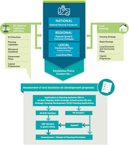
The study was designed to gain an empathic depth of knowledge concerning the understanding of 3D spatial media by local authority planning departments and their existing and potential future use in Ireland. Local authorities are just one component of the Irish planning system (see ), but they are the key agencies in plan- and decision-making, centrally involved in pre-planning processes, evaluating and approving planning applications, and enforcement. It should be noted, however, that planning departments in Ireland are small and not well resourced compared to other jurisdictions, especially after a decade of downsizing and underinvestment following the 2008 financial crash (Williams & Nedovic-Budic, Citation2020). By observing, engaging, and empathizing with local authority planners directly, our aim was to create insights into their experiences and motivations, how technology is enrolled and used in context, how local authorities might use 3D technology in their day-to-day processes, how useful they think 3D spatial media might be, and how they feel about using it. The most appropriate way to gain such insights is to use a qualitative approach. Such an approach is well established in planning as a means to generate data concerning values, opinions, beliefs, and judgments, as well as individual and institutional choice and decision making (Dandekar, Citation1986; Gaber, Citation2007).
Figure 1. An overview of the Irish planning system (source: Department of Housing, Planning, and Local Government, Citation2018)
Our study consisted of 14 in-depth interviews with experienced Local Authority (LA) planners in the Republic of Ireland: Senior Executive Planner (n = 5), Senior Planner (n = 4), Executive Planner (n = 3), a Senior Architect (n = 1), and a technical staff member (n = 1). The interviewees worked for six different LAs across the country. A number of the planners had experience working overseas and in private industry, as well as in other Irish LAs. Collectively they had 255 years of experience in the planning domain with a mean number of years’ experience of 18.21 (SD = 4.89) and had worked across all aspects of local government planning (e.g. strategic planning, development management, compliance, and enforcement). Data collection took place over three months from November 2018 to January 2019. Interviewees were recruited via email, with potential respondents identified via a snowball method to help source an appropriately qualified peer user group. All sessions were conducted face-to-face at locations and times that suited each individuals’ requirements (in all cases their workplace). The interviews were all recorded and transcribed, with a mean interview time of 50 minutes (SD = 5 min). The interview followed a semi-structured design and employed an interview-laddering technique to systematically explore the same core topics with each participant (Hawley, Citation2009; see ‘core themes’, ).
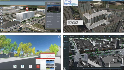
First, interviewees were asked about their knowledge and experience of using 3D tools. Second, they were queried as to the present and potential use of 3D spatial media in the planning system in Ireland. Third, they were asked about current and future user needs and requirements. Fourth, interviewees were probed as to the likely future use of 3D tools in their LA work. Finally, interviewees were shown a 15-minute video of four 3D planning tools (RealSim, VU.City, Virtual Singapore, and a prototype CIM system for Dublin, Ireland) (see ) and were asked to ‘think-aloud’ and discuss their potential utility in their planning practice and possible shortcomings.
Figure 2. Interview laddering of 3D tools in urban planning and identifying core themes and topics
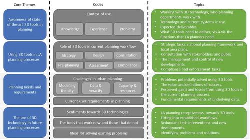
Figure 3. The four 3D spatial media shown to interviewees (top left, RealSim; top right, Virtual Singapore; bottom left, VU.City; bottom right, Building City Dashboards prototype)
The interviews were transcribed and then coded in MaxQDA. Rather than using a grounded theory approach, in which categorization emerges from the data, the transcript data were first categorized into the core rungs of our laddering technique, and first-level concepts were extracted as selective ‘motifs’. Following this, second-level categories were then identified as topics of interest discussed by the interviewees. This way our analysis was structured as per the interview ladder (see ), providing a focused view that matched our objectives of understanding the current state-of-play and eliciting user requirements.
While our cohort is quite small, given the profile and experience of the interviewees and the quick establishment of saturation in the sample, it does provide valid insights into the status of 3D spatial media in Ireland. In qualitative research, saturation denotes the point at which no new critical insights, themes, or positions are being articulated, with there being a strong alignment of views across participants (Bowen, Citation2008). In our study, a strong overlap in opinions and experiences across our interviewees was quickly established. While our sample might be representative of views within the Irish planning system, there is a question as to whether they are shared elsewhere. There are reasons to believe that they will have resonance beyond Ireland as the themes and reasoning that were voiced with regards to 3D data availability, quality and interoperability, issues of finance and IT resourcing, skills capacity, and institutional barriers are common across jurisdictions, especially in neoliberal regimes where local authorities are operating within austerity measures and for smaller local authorities with limited capacities (Williams & Nedovic-Budic, Citation2020). Regardless, they provide insights into how 3D spatial media are presently viewed and used within the Irish context.
The Knowledge and Experience of Planners Concerning 3D Spatial Media
The 14 people we interviewed were all experienced planners. Their knowledge of 3D approaches to planning and the various products available was broad. However, their applied experience of using 3D spatial media was constrained, and the cohort admitted having very little hands-on experience of using such tools in their day-to-day work (and we have not met any public sector planner in Ireland over the past four years with any moderate to extensive experience). They noted that a small number of colleagues might produce bespoke 3D models as part of their work, but this depended on the project and skills of particular team members. The use of 3D spatial media was not generally seen as a constituent part of mainstream practice for LA planners.
Instead, the common view was that utilization of 3D applications was largely the purview of architects and developers, particularly those working within Special Development Zones (SDZs) and large city management ‘master plans’ where multiple investors, developers, and phases of development were to be implemented over long periods. Here, beyond the use of CAD and BIM for designing and managing architectural design and construction, 3D media were being used as marketing and sales tools for larger developments, as well as planning consultancy tools for use within local communities. Many of the existing applications of 3D focused on the production of ‘fly-through’ animations demonstrating what a development would look like upon completion. Occasionally, a physical tabletop model would also be constructed, though as ZZ66 (Senior Planner) stated:
… you have to warrant doing it, but then the real value we get out of it is maybe sometimes the 3D, that’s a physical model, brings to life the proposal in a way that you don’t tend to see in drawings.
The senior planners identified themselves as typically being skilled in more traditional analog techniques and approaches to three-dimensional thinking (e.g. perspective drawings). However, they were very used to reviewing the 3D outputs of developers and architects as the basis for their deliberations. Examples were given that related to overall master planning, landscape architecture, visual impact assessment, land-use conceptualization, and planning for transport infrastructures (including the simulation of proposed metro links, roads, and motorway plans). They were all familiar with the outputs of terrain surveying techniques such as LIDAR (light detection and ranging), and photogrammetry, but had limited direct experience of using these techniques for 3D reconstructions. Those that did have experience of working with 3D models tended to use Bentley MicroStation for creating simple 3D massing, or 3D modeling packages like SketchUp for architectural detailing and the creation of axonometric views and ‘street-level’ perspectives. For example, as one interviewee noted:
I have some experience with MicroStation and CAD and SketchUp to do very simple, you know, 3D models of objects with regular shapes, but not much more than that. – GF83 (Technical Staff Member)
There were also occasional instances of open-source software applications being used. For example, MeshLab had been used extensively by one department to assist in simplifying the geometric ‘meshes’ that form the underlying structure of digital 3D models and segmenting them to attach digital photos that provide photorealistic textures.
In some cases, the planners were aware of 3D projects in which the LA was a stakeholder or in which they were participating in a managerial capacity. For example, one senior planner was working on a co-design project to engage the public with 3D models:
A project that I’m working on at the moment … is looking at how we engage with communities and it’s looking at moving towards more visual engagement, and we’ve been looking at, with IT departments, we’ve been looking at gaming, gamification [using a 3D model in a games engine] to get people to – younger people in particular – to get involved in consultation that we’re doing. – KB25 (Senior Executive Planner)
Generally, the planners were unaware of the broader utilization of game engines, such as Unity and Unreal Engine, for interactive visualizations. Instead, they tended to use Google Maps and Google Earth to supplement their use of site plans and photographic reference materials. As noted by one planner:
The only other way we look at things, sometimes we would go to Google Maps or Google Earth … we use that 3D kind of bird’s eye view quite a lot just to get an idea of what’s going on, on-site. – MG14 (Senior Executive Planner)
These tools were often consulted to better understand the suitability of design choices regarding the use of materials and façade renderings and to get a better ‘feel’ for the location and its context before leaving the office for a site visit.
Other 3D use cases that were discussed included the simulation and testing of new design scenarios, objectives, and policies that could be incorporated into the development of local area plans. The potential integration of 3D data with other smart city technologies such as real-time sensing devices, the utility of building information models (BIMs), and the potential of 3D GIS was also acknowledged. However, current uses of 3D in the LA planning departments we consulted largely focused on the visual aspects of communication and assessment.
The Potential Use of 3D Spatial Media in Planning
While the use of 3D spatial media in planning departments was relatively limited, all the interviewees recognized their potential to contribute to the planning system and their day-to-day work. Our cohort widely expected that the use of 3D spatial media could benefit strategic visioning, public consultation, pre-planning processes, development management, application assessment, compliance, and enforcement. However, the perceived utility also varied depending on the task.
With strategic visioning, 3D spatial media were seen as affording the ability to masterplan and test different scenarios by providing an interactive 3D model of the environment. Models included terrain and landscape features that could be viewed from multiple perspectives (bird’s-eye and street-level) and were expected to provide a more concrete perceptual reference than maps and plans, particularly with the inclusion of textures. It was suggested that design scenarios should be quickly built and modified – by importing, scaling, rotating, rearranging, and editing 3D models – and this would be much less time consuming, expensive, and wasteful than working with physical 3D models. The digital model would enable a quick visual assessment of proposed developments and the wider effects a development may have on the existing landscape before any significant investment. It would demonstrate how multiple developments work together spatially, rather than as isolated plots, and temporally in terms of the dependencies that unfold through the phasing of each project. For example, IT15 (Senior Executive Planner) suggested that dynamic 3D models have some potential:
… to be able to show how it’s all coming together … fitting together, you know, and if one element doesn’t happen, for whatever reason, you know, in terms of the phasing even, to build up different stages of the development.
An interactive 3D model was also thought to enable a more thorough interrogation of the developer’s proposals. Currently, developers present a range of perspective drawings and photomontages at pre-planning meetings or submit them as part of their planning applications. Planners were somewhat circumspect about these documents because the images are static and carefully curated to provide a particular impression, usually to minimize the overall impact of the proposal on the surrounding area. The angle of view and the inclusion of features such as trees and street furniture might also obscure important details.
… they’re from a particular angle or particular view and you get the 3-D view in, but that’s it, it’s just the one angle. – ZZ66 (Senior Planner)
The value of a more fully interactive and explorable 3D model was, therefore, the possibility to shift viewpoints and to turn on or off layers of information that would enable planners and third parties to gain a more holistic impression.
The planners considered that 3D spatial media could play a useful role in planning application and compliance assessments. For example, it would be possible to drop a 3D model of a proposed development into a model to visually assess its keeping with the local character of the environment and its impact on sightlines. Using sunlight and shadow modeling tools it would be possible to assess the impact of raised building heights on surrounding properties. Flood modeling tools could give an approximate indication of the potential for localized flooding under different scenarios. The 3D tools and accompanying 3D model might also enable more informed conversations with other stakeholders from other LA departments or external parties who could provide support with specialist domain knowledge.
Some interviewees speculated that showing models of prospective developments to objectors might help appease them, or else form the basis for negotiating alterations and help with the appeals process. However, there was also an acknowledgment that the bulk of a planning assessment constitutes a routine set of checks to establish that a development complies with relevant standards, regulations, and codes regarding its form and materials, infrastructural requirements, and environmental and local area impacts. Such assessments can include a site visit, at which stage a 3D model was considered to provide limited utility. The possibilities of overlaying a 3D representation of the as-built building over the 2D plans, or of accurately overlaying a geolocated 3D model for on-site assessment in AR, were viewed to have future potential. For the present, however, it was felt that the development and use of 3D spatial media required an expensive investment in data, tools, staffing, and training to conduct assessments on a limited number of criteria that are already being handled adequately. This indicates that the expected efficiencies and cost savings are yet to be adequately demonstrated to all planning practitioners.
The planners were aware that the AEC industry has been using 3D spatial media to help manage new construction projects, but also in the sales and procurements process, and viewed that this had potential value in their organizations. There has been a clear and noticeable shift in the construction industry towards 3D modeling, especially BIM which is used to manage large-scale developments (Crotty, Citation2011). However, while the planners recognized the value of adopting these assets, only one of the LA planning departments we interviewed said that they had the necessary technology for opening and viewing BIM files but lacked BIM specialist staff.
At a local scale, the planners envisaged that the most viable uses of 3D spatial media would be to enable the visioning and designing of local area development plans and to explore options for zoning and infrastructure in large-scale urban developments. They also speculated that an open access online 3D viewer would enable the public to inspect the impact of individual planning applications on the streetscape via interactive walkthroughs or bird’s-eye views. Such tools would give a sense of scale and the relationships between the existing landscape and different development sites. As GF83 (Technical Staff Member) noted:
Both from the public perspective and the council perspective as well. … to be able to visualize part of the city in 3D and see how a new development would fit within the surrounding area, it’s beneficial for the planners … And, for the public, where they can have an idea what the development will look like.
Similarly, MG14 (Senior Planner) stated:
… it would be easier for us to judge how it would look overall and for members of the public to also get a better idea of what’s being proposed.
3D spatial media could also facilitate public debate (e.g. concerning building heights and densities) and the gathering of informed feedback on individual developments (e.g. the regeneration of brownfield sites) and wider strategic plans (e.g. creating new towns on greenfield sites). It was highlighted that although planning applications and accompanying photomontages of new developments may be made available to local communities during consultations, they may not be fully transparent on how a proposed development will look and fit within the wider landscape upon completion. At present, the planners noted, developers and the planning system more generally have little sympathy with the public’s difficulty in interrogating plans or planning proposals. It was considered that 3D spatial media could significantly aid public comprehension of planning issues and enable the public to make more informed decisions. For example, concerning building heights where the public tends to be resistant to high-rise developments without necessarily investigating how such buildings would look against, and impact, the surrounding landscape.
The planners also expressed the view that a 3D platform would assist their work in liaising with local councilors who are often seeking information or lobbying on behalf of the communities they represent. In all cases, the elected members must be assisted, one-to-one, in the exploration and presentation of development plans to their constituents. Furthermore, it was noted that councilors do not necessarily have the relevant domain knowledge to fully comprehend planning documents and decisions relating to planning applications. An accessible 3D spatial media could make planning applications more comprehensible and speed up such interactions with councilors. The perceived value of such tools is derived from the impression of physical reality conveyed; they could bring a proposal to life and communicate its relation to human-scale in a way that drawings alone could not. This ability was expressed as:
… sometimes there’s nothing like getting down, putting your head down here at street level … and actually looking up the street and you see how this new building is going to fit in at that level. – ZZ66 (Senior Planner)
The consolidation of tools with an integrated CIM would also help with other work within the LA: visualizing and contrasting multiple spatial data sets to aid planners, housing officials, and developers concerning the scoping of (re)development opportunities; determining the optimum spatial solutions for large-scale public works; providing contextual information for on-going urban management and operation and conveying the competitiveness of the district to potential investors. The planners were aware that other cities (London, Singapore, etc.) continue to utilize the 3D models associated with completed developments to assist in ongoing operational activities like building maintenance and the wider integration of smart city districts. By demonstrating the value generated through this diversity of uses the planners believed they would also gain the support of senior managers for more widespread use of 3D spatial media within their organizations, as HI37 (Senior Planner) noted:
… from a chief executive’s point of view, the more we kind of embrace technology and have that evidence base, we can make the arguments around why invest in [the city].
Prospects for the Adoption of 3D Spatial Media in Planning in Ireland
The participants generally positioned themselves as receptive to 3D spatial media and were open to the use of such tools in their day-to-day tasks. When shown the video of the four 3D planning tools, some were enthusiastic about their potential (though this varied between platforms) and that they had potential utility for planning practice. However, they were also cautious as to the extent to which the 3D spatial media would reshape planning work and the prospects of their adoption. This caution was multifaceted and included concerns over their suitability to existing regulatory processes, the availability of institutional support, the skills capacity and resourcing required, and the practical effort involved in realizing their utility. For example:
I don’t think there’s been enough of a discussion about the expertise that’s needed in government … I think the government needs to get up to speed on these digital platforms because in terms of making information accessible to people, it’s the way to do it. – XT78 (Senior Architect)
While the planners recognized the potential value of 3D spatial media, they were also skeptical as to whether they would deliver benefits that represented a favorable return-on-investment. Moreover, it was expressed that their utility was more geared towards the design, pre-planning, and consultative aspects of development and planning, with a limited function in assessment and compliance. Factors such as the lack of demonstrable return on investment for applications of VR/AR beyond initial pilots and research projects, the perceived absence of mainstreamed operational CIM internationally, and the feeling that many existing functionalities failed to provide for the planner’s requirements, did not inspire confidence.
It’s still just a visual thing. It’s nothing about how this place is going to function in terms of how the city as a whole functions … we get a lot of, ‘Oh, you know, we need to have a 3D model of the city ‘and I’m like, well, for what? – XT78 (Senior Architect)
Even if an LA wanted to pursue the use of 3D spatial media in its planning work, it was considered that they currently lacked the resources and skillsets needed for implementation and on-going maintenance. LAs have limited budgets and technology infrastructures that have suffered from over a decade of under-investment due to strong austerity cuts. Existing e-governance systems would need to be upgraded to enable ePlanning to be capable of handling 3D datasets. Few LA employees have the required skillsets for managing and maintaining 3D data/models and using 3D tools, and they would either need to be recruited, or existing staff retrained. As one senior planner (IT15) noted:
My fear is that we’ll end up with something that there’s only two or three people in the council can use. They’ll get overwhelmed because everybody then goes to them for those particular tasks because there’s nobody else that could do it … It’s not going to be much good to us unless it can be used.
Creating a detailed, realistic 3D model of a city that has associated spatial data to enable planners, as well as stakeholders and the public, to better understand the context of development and decision-making is a highly specialized and expensive undertaking relative to the budgets allocated to the respective LAs. Indeed, the availability of 3D spatial data is a major problem in Ireland, although Ordnance Survey Ireland is working on a national 3D geographic dataset for projected release in 2023 (with a limited level of detail and no photo-realistic skins). Moreover, maintaining a 3D model over time is also a challenging, specialist task (Thompson et al., Citation2016). As such, much of the initial set-up work (e.g. creating 3D models or setting up systems), as well as maintenance, would probably need to be outsourced to private companies, which might run the enterprise as a service. Yet departments lack the finance to fund such services. There was a concern also as to whether planning departments would be able to handle, verify the veracity, and track a large number of models. Regarding data veracity and age, one senior planner stated that:
The information you have on it has got to be accurate. It ought to be up-to-date. If it’s not up-to-date, you’re going to be challenged. – DV36
Another senior planner also noted that their department presently had 23 applications for the development of 100-plus housing units, plus a couple of thousand below 100 units a year. Some of these developments would need to be added to the master model, others might go through several iterations or never take place. While 3D technology could assist in the management of this process, the process itself would likely need to change to achieve the intended benefit.
It was thus acknowledged by interviewees that some effort from senior planning members would be required to drive the future 3D spatial media agenda within the planning system, as it was universally identified as a disruptive technology with the potential to alter the overall urban management process. Also, senior management within LAs would need to enable the enterprise by providing leadership support and resources for equipment, infrastructure, staffing, and capacity building. Without this leadership and support, 3D spatial media were seen as a potential ‘rabbit hole’ that could be an expensive endeavor, requiring extensive organizational effort and commitment of resources. They recognized that for support to be mobilized, the new technology investment would need to prove itself useful beyond normal planning work. For example, it would need to be demonstrated that by embracing 3D spatial media, the LA gained an evidence-based system that would bolster arguments for further investment in a development plan and built stakeholder alliances, or could be used to attract firms and jobs. If this were to happen, then it was thought that the required drivers for the implementation of such systems would gain momentum very quickly.
Concerning day-to-day planning, crucially, there would also need to be a change in current planning workflows and procedures and the regulatory environment. For example, the planning proposal process would have to enforce the submission of 3D models that can be individually interrogated and be placed into a master 3D model for further contextual evaluation. The current planning system was described as ‘problematic’, as “the statutory system doesn’t allow for them [3D models] or digital presentations of application” (DV36, Senior Planner). Nor does it allow planners to construct their models for assessment purposes. It was acknowledged that this might change with the introduction of the new ‘ePlanning’ system, where an electronic submission process would be compulsory. However, it was also noted that most planning applications are for small domestic extensions and new dwellings. These types of applications are presently accompanied by 2D plans and aspects, and it will be an additional burden for applicants to source a 3D model. These changes would need to be accompanied by wider national and international work to establish guidelines, principles, and standards for producing 3D spatial media for planning concerning visualization, tools, and their application to planning practices and processes (Appleton & Lovett, Citation2005; Wissen, Citation2011). Although significant work has taken place concerning data via the CityGML initiative,Footnote2 plenty of data and other issues persist that create uncertainty (Groger & Plumer, Citation2012; Stojanovski, Citation2018).
Conclusions
For three decades there has been R&D and speculation concerning 3D spatial media for planning. While there has been some progress in terms of developing a suite of new applications, such as 3D sketch packages; 3D GIS, VR/AR, BIM, CIM, and data standards such as CityGML, to date 3D spatial media has made limited impact on the day-to-day work of local government planning departments. The slow adoption of 3D spatial media is not just confined to the planning arena but has occurred across other domains (Evans, Citation2019). Despite considerable advances in technology throughout the 2010s, high-quality 3D data with good spatial resolution remains difficult to source, and adding an array of other spatial data into the models remains challenging (Thompson et al., Citation2016). There are question marks as to whether the data are of sufficient quality and credibility to be used in a legal process such as planning decisions. The systems require advanced technical skills that are often absent from planning departments and which require specialist staffing. There have been few deployments for public consultation and little evidence as to their effectiveness or value for investment over traditional approaches. Our interviewees, while being aware of some of the potential benefits of 3D spatial media, were largely skeptical as to their adoption within public sector planning in the near future, and questioned their utility for different stages of the planning process.
Based on these findings cautious enthusiasm in adopting 3D spatial media makes sense. Potentially, 3D spatial media offers useful tools for strategic planning and development management. However, the planning system, as it is currently resourced and operated, provides significant challenges with few incentives for adoption. This mirrors the adoption of GIS in planning in the 1980s and 1990s, with take-up slow and piecemeal due to technological and organizational factors, and when it was used it was for basic support rather than higher-level tasks (Masser et al., Citation1996; Nedovic-Budic, Citation1999), a situation that still largely persists. While sympathetic to the potential utility of 3D spatial media, our interviewees were skeptical as to their prospects for being adopted as mainstream tools in the short term. Beyond institutional and structural concerns, there is uncertainty as to whether 3D spatial media will deliver the outcomes desired, and in a way that is useable by the majority of planners without significant re-training. In particular, there is a perception that the tools have more utility for designers and developers in producing and selling plans, and are more suited to strategic visioning, pre-planning, and public consultation, than planning assessment and compliance, which make up the bulk of planning work in local government. There is certainly a sense that 3D spatial media will complement and augment traditional planning practices rather than usurp them (Gill et al., Citation2013).
Surprisingly, there has been little research that scoped out in detail the user requirements of planners with regards to 3D spatial media or assessed how planners view and use 3D tools, and their effectiveness in aiding and improving the planning system (Gill et al., Citation2013; Paar, Citation2006; Portman et al., Citation2015; Wissen, Citation2011). Instead, research has concentrated on developing experimental tools and early commercial offerings that seem more interested in tackling research questions (solving how to do something) or creating functional commercial offerings (demonstrating possibilities and creating new markets), than providing tools that are tailored to the day-to-day practices of planning. Similarly, there has been too little attention paid to producing 3D models of sufficient data quality for planning purposes, and subsequent data management and on-going maintenance: tools without a pipeline of high-quality data will not be adopted.
Implementations of the CityGML standard in Helsinki (KIRA-digi, Citation2019) and Singapore (Soon & Khoo, Citation2017) highlight opportunities and challenges. In the case of Helsinki, the investment in a second ‘reality mesh’ model for visualization provides a pragmatic compromise between providing a data-rich CIM and the kind of visual fidelity users have been long been encouraged to expect from applications like Google Earth. CityGML provides a data model and schema for a database that incorporates 3D data and semantic information at varying levels of detail. Effective use and management of CityGML demands a different set of skills, capacities, organizational processes, and infrastructure than might be expected when procuring a 3D model for certain applications in planning. In a review of the challenges experienced in the procurement of 3D city models across Finland, researchers found that ‘the lack of expertise was seen to result in an incapacity to recognize the need for 3D city modeling, and hence to define the requirements for 3D city modeling. […] Hence, more capacity building was required for the cities to drive 3D city modeling to its full potential’ (Julin et al., Citation2018).
While our research has focused on planning in Ireland, the issues raised are relevant to planning elsewhere. Our analysis leads us to three conclusions. First, there is potential value in 3D spatial media for planning. This utility is powerful for commercial planners working with developers and as a support tool for public sector planners. Second, there is a significant adoption gap within planning for 3D spatial media, in part caused by limitations in the design and operation of the tools and in part by structural and institutional barriers and skepticism as to their use and technocratic approaches to planning. Third, closing this adoption gap will not be straightforward as it requires instrumental and structural interventions in environments that remain skeptical of the potential benefits and are starved of resources that would enable their adoption and mainstreaming.
Despite these barriers, several steps can be taken to address the adoption gap at a practical, pragmatic level. The developers of 3D planning tools need to work more closely with practicing planners, undertaking user requirements and iterative user-centered evaluation in the design and production of tools to ensure that they align with needs and effectively contribute across the various stages and components of planning practice. This approach needs to be accompanied by closely monitored trial deployments of systems in local government planning, moving beyond development and prototyping, to assess the merits and issues arising from use, including evaluating structural and institutional concerns and formulating mitigation strategies. The critical issue of extensive, persistent, high-quality 3D datasets can only partially be addressed at a local level through municipalities working with third party suppliers, and requires national planning bodies to join forces with other stakeholders (commercial and research bodies) to push for a national policy for developing such data and associated standards as a strategic priority (these datasets will undoubtedly have a variety of other high-value uses). As these developments are introduced, a cost-benefit case needs to be produced to justify the re-alignment of constrained resources and staff attention and best practice guidelines produced to direct deployment. This tactic should be accompanied by the provision of training for practicing planners and the integration of these tools in planning degree programmes. Unless planners have the skillset to utilize and interpret 3D spatial media, the associated data, tools, and techniques will remain un- or under-employed in practice. Without these interventions, the transition from prototype systems to mainstreaming will be more haphazard as it will be less aligned to the needs of the planning system and planners, and is less likely to address the structural and institutional concerns that will fast-track adoption.
Disclosure Statement
No potential conflict of interest was reported by the author(s).
Additional information
Funding
Notes on contributors
Rob Kitchin
Rob Kitchin is a professor in Maynooth University Social Sciences Institute and Department of Geography. He was a European Research Council Advanced Investigator on the Programmable City project (2013–2018) and a principal investigator on the Building City Dashboards project (2016–2020) and has published widely on the relationship between technology, space and society.
Gareth W. Young
Gareth W. Young is a postdoctoral research fellow on the V-SENSE project at Trinity College Dublin, and formerly worked on the Building City Dashboards project at the National Centre for Geocomputation (NCG), Maynooth University. Gareth’s research focuses on evaluating real-world uses and design effectiveness of cross-reality (XR) technology using human-computer interaction (HCI) evaluation techniques.
Oliver Dawkins
Oliver Dawkins is a researcher on the Connected Environments project at the Bartlett Centre for Advanced Spatial Analysis (CASA), University College London, and formerly worked on the Building City Dashboards project at Maynooth University in Ireland. His research focuses on the use of geographic information in 3D, sensors and real-time data, mixed realities, and advanced visualisation technologies.
Notes
1. There is some ambiguity and confusion over terms and definitions regarding media used for planning. In this paper, we use the following terms as defined:• Spatial media: any media with a spatial component.• 3D spatial media: spatial media referencing a third spatial dimension, e.g. x, y, z axes (VR, AR, CAD, 3D modeling, 3D architectural models, etc).• 3D data: data that are spatially referenced in three dimensions.• 3D model: 3D data describing an object or set of objects and their appearance. • 3D tools: functionality within packages for manipulating and displaying 3D data. • 3D interaction devices: hardware that can be used to display and interact with 3D spatial media (e.g. head-mounted displays, mobile phones, 3Dof/6Dof controllers, etc).
2. CityGML is the international standard of the Open Geospatial Consortium (OGC) for the representation and exchange of 3D city models. It defines the three-dimensional geometry, topology, semantics, and appearance of topographic objects.
References
- Al-Kodmany, K. (2002). Visualization tools and methods in community planning: From freehand sketches to virtual reality. Journal of Planning Literature, 17(2), 189–211. https://doi.org/10.1177/088541202762475946 .
- Appleton, K., & Lovett, A. (2005). GIS-based visualization of development proposals: Reactions from planning and related professionals. Computers, Environment and Urban Systems, 29(3), 321–339. https://doi.org/10.1016/j.compenvurbsys.2004.05.005 .
- Ball, J., Capanni, N., & Watt, S. (2007). Virtual reality for mutual understanding in landscape planning. International Journal of Information and Communication Engineering, 1(11), 661–671. https://doi.org/10.5281/zenodo.1084222 .
- Bowen, G. A. (2008). Naturalistic inquiry and the saturation concept: A research note. Qualitative Research, 8(1), 137–152. https://doi.org/10.1177/1468794107085301 .
- Crotty, R. (2011). The impact of building information modelling: Transforming construction. Routledge.
- Dandekar, H. C. (1986). Some uses and potentials of qualitative methods in planning. Journal of Planning Education and Research, 6(1), 42–49. https://doi.org/10.1177/0739456X8600600110 .
- Department of Housing, Planning, and Local Government. (2018). National planning framework: Project Ireland 2040. Government Publications.
- Deutsch, R. (2017). Convergence: The redesign of design. John Wiley & Sons.
- Döllner, J. (2006). Real-time virtual landscapes. In W. Cartwright, M. Peterson, & G. Gartner (Eds.), Multimedia cartography (pp. 241–254). Springer.
- Doyle, S., Dodge, M., & Smith, A. (1998). The potential of web-based mapping and virtual reality technologies for modeling urban environments. Computers, Environment and Urban Systems, 22(2), 137–155. https://doi.org/10.1016/S0198-9715(98)00014-3 .
- Drettakis, G., Roussou, M., Reche, A., & Tsingos, N. (2007). Design and evaluation of a real-world virtual environment for architecture and urban planning. Presence: Teleoperators and Virtual Environments, 16(3), 318–332. https://doi.org/10.1162/pres.16.3.318 .
- Drummond, W. J., & French, S. P. (2008). The future of GIS in planning: Converging technologies and diverging interests. Journal of the American Planning Association, 74(2), 161–174. https://doi.org/10.1080/01944360801982146 .
- Evans, L. (2019). The re-emergence of virtual reality. Routledge.
- Flood, J. (2011). The fires: How a computer formula, big ideas, and the best of intentions burned down New York City and determined the future of cities. Riverhead.
- Forrester, J. W. (1969). Urban dynamics. MIT Press.
- Franklin, R., Heesom, D., & Felton, A. (2006). A critical review of virtual reality and geographical information systems for management of the built environment. Proceedings of tenth international conference on information visualisation (IV’06) (pp. 349–356). IEEE.
- Friedmann, J., & Hudson, B. (1974). Knowledge and action: A guide to planning theory. Journal of the American Institute of Planners, 40(1), 2–16. https://doi.org/10.1080/01944367408977442 .
- Gaber, J. (2007). Qualitative analysis for planning and policy. Routledge.
- Ghadirian, P., & Bishop, I. D. (2008). Integration of augmented reality and GIS: A new approach to realistic landscape visualization. Landscape and Urban Planning, 86(3–4), 226–232. https://doi.org/10.1016/j.landurbplan.2008.03.004 .
- Gill, L., Lange, E., Morgan, E., & Romano, D. (2013). An analysis of usage of different types of visualization media within a collaborative planning workshop. Environment and Planning. B, Planning & Design, 40(4), 742–754. https://doi.org/10.1068/b38049 .
- Gordon, E., & Manosevitch, E. (2010). Augmented deliberation: Merging physical and virtual interaction to engage communities in urban planning. New Media & Society, 13(1), 75–95. https://doi.org/10.1177/1461444810365315 .
- Gordon, E., Schirra, S., & Hollander, J. (2011). Immersive planning: A conceptual model for designing public participation with new technologies. Environment and Planning. B, Planning & Design, 38(3), 505–519. https://doi.org/10.1068/b37013 .
- Grieves, M., & Vickers, J. (2017). Digital twin: Mitigating unpredictable, undesirable emergent behavior in complex systems. In F. J. Kahlen, S. Flumerfelt, & A. Alves (Eds.), Transdisciplinary perspectives on complex systems (pp. 85–113). Springer.
- Gröger, G., & Plümer, L. (2012). CityGML – Interoperable semantic 3D city models. ISPRS Journal of Photogrammetry and Remote Sensing, 71, 12–33. https://doi.org/10.1016/j.isprsjprs.2012.04.004 .
- Gu, N., Kim, M. J., & Maher, M. L. (2011). Technological advancements in synchronous collaboration: The effect of 3D virtual worlds and tangible user interfaces on architectural design. Automation in Construction, 20(3), 270–278. https://doi.org/10.1016/j.autcon.2010.10.004 .
- Hawley, M. (2009). Laddering: A research interview technique for uncovering core values. UXmatters. Retrieved September 20, 2017, from https://www.uxmatters.com/mt/archives/2009/07/laddering-a-research-interview-technique-for-uncovering-core-values.php .
- Julin, A., Jaalama, K., Virtanen, J. P., Pouke, M., Ylipulli, J., Vaaja, M., Hyyppä, J., & Hyyppä, H. (2018). Characterizing 3D city modeling projects: Towards a harmonized interoperable system. ISPRS International Journal of Geo-Information, 7(2), 55. https://doi.org/10.3390/ijgi7020055 .
- Kim, T. J., Wiggins, L. L., & Wright, J. R. (1990). Expert systems: Applications to urban planning. Springer-Verlag.
- KIRA-digi. (2019). The Kalasatama digital twins project. Ministry of the Environment.
- Kitchin, R., Dawkins, O., & Young, G. (2019). Prospects for an intelligent planning system. Planning Theory and Practice, 20(4), 595–599. https://doi.org/10.1080/14649357.2019.1651997 .
- Koninger, A., & Bartel, S. (1998). 3D-GIS for urban purposes. GeoInformatica, 2(1), 79–103. https://doi.org/10.1023/A:01009797106866 .
- Krivỳ, M. (2018). Towards a critique of cybernetic urbanism: The smart city and the society of control. Planning Theory, 17(1), 8–30. https://doi.org/10.1177/1473095216645631 .
- Levy, R. M. (1995). Visualization of urban alternatives. Environment and Planning. B, Planning & Design, 22(3), 343–358. https://doi.org/10.1068/b220343 .
- Light, J. S. (2003). From warfare to welfare: Defense intellectuals and the urban problems in Cold War America. John Hopkins University Press.
- Masser, I., Campbell, H., & Craglia, M. (Eds.). (1996). GIS diffusion: The adoption and use of geographical information systems in local government in Europe. Taylor & Francis.
- Nedovic-Budic, Z. (1999). Evaluating the effects of GIS technology: Review of methods. Journal of Planning Literature, 13(3), 284–295. https://doi.org/10.1177/08854129922092405 .
- Orlanda, B., Budthimedheeb, K., & Uusitaloc, J. (2001). Considering virtual worlds as representations of landscape realities and as tools for landscape planning. Landscape and Urban Planning, 54(1–4), 139–148. https://doi.org/10.1016/S0169-2046(01)00132-3 .
- Paar, P. (2006). Landscape visualizations: Applications and requirements of 3D visualization software for environmental planning. Computers, Environment and Urban Systems, 30(6), 815–839. https://doi.org/10.1016/j.compenvurbsys.2005.07.002 .
- Pettit, C., Bakelmun, A., Lieske, S. N., Glackin, S., Hargroves, K., Thomson, G., Shearer, H., Dia, H., & Newman, P. (2018). Planning support systems for smart cities. City, Culture and Society, 12(1), 13–24. https://doi.org/10.1016/j.ccs.2017.10.002 .
- Pietsch, S. M. (2000). Computer visualization in the design control of urban environments: A literature review. Environment and Planning. B, Planning & Design, 27(4), 521–536. https://doi.org/10.1068/b2634 .
- Portman, M. E., Natapov, A., & Fisher-Gewirtzman, D. (2015). To go where no man has gone before: Virtual reality in architecture, landscape architecture, and environmental planning. Computers, Environment and Urban Systems, 54(1), 376–384. https://doi.org/10.1016/j.compenvurbsys.2015.05.001 .
- Salter, J. D., Campbell, C., Journeay, M., & Sheppard, S. (2009). The digital workshop: Exploring the use of interactive and immersive visualization tools in participatory planning. Journal of Environmental Management, 90(6), 2090–2101. https://doi.org/10.1016/j.jenvman.2007.08.023 .
- Schmalstieg, D., & Reitmayr, G. (2007). The world as a user interface: Augmented reality for ubiquitous computing. In G.Gartner, W.Cartwright & M. P. Peterson (Eds.), Location based services and telecartography. Lecture Notes in Geoinformation and Cartography. https://doi.org/10.1007/978-3-540-36728-4_28 .
- Schreyer, A. C. (2013). Architectural design with sketchup: Component-based modelling, plugins, rendering, and scripting. John Wiley & Sons.
- Shiratuddin, M. F., & Thabet, W. (2011). Utilizing a 3D game engine to develop a virtual design review system. Journal of Information Technology in Construction, 16(1), 39–68. https://www.itcon.org/paper/2011/4
- Soon, K. H., & Khoo, V. H. S. (2017). CityGML modelling for Singapore 3D national mapping. International Archives of the Photogrammetry, Remote Sensing and Spatial Information Sciences, XLII-4(W7), 37–42. https://doi.org/10.5194/isprs-archives-XLII-4-W7-37-2017 .
- Stojanovski, T. (2018). City information modelling (CIM) and urban design: Morphological structure, design elements, and programming classes in CIM. In A. Kepczynska-Walczak & S. Bialkowski (Eds.). Proceedings of the 36th eCAADe conference – volume 1 (pp. 507–516). Lodz University of Technology.
- Sunesson, K., Allwood, C., Paulin, D., Heldal, I., Roupé, M., Johansson, M., & Westerdahl, B. (2008). Virtual reality as a new tool in the city planning process. Tsinghua Science and Technology, 13(1), 255–260. https://doi.org/10.1016/S1007-0214(08)70158-5 .
- Thompson, E. M., Greenhalgh, P., Muldoon-Smith, K., Charlton, J., & Dolník, M. (2016). Planners in the future city: Using city information modelling to support planners as market actors. Urban Planning, 1(1), 79–94. https://doi.org/10.17645/up.v1i1.556 .
- Webber, M. (1965). The roles of intelligence systems in urban-systems planning. Journal of the American Institute of Planners, 31(4), 289–296. https://doi.org/10.1080/01944366508978182 .
- Williams, B., & Nedovic-Budic, Z. (2020, online first). Transitions to spatial planning in Ireland: Moving from a localised to a strategic national and regional approach. Planning Practice and Research, 1–20. https://doi.org/10.1080/02697459.2020.1829843 .
- Wissen, U. (2011). Which is the appropriate 3D visualization type for participatory landscape planning workshops? A portfolio of their effectiveness. Environment and Planning. B, Planning & Design, 38(5), 921–939. https://doi.org/10.1068/b36113 .
- Yigitcanlar, T. (2016). Technology and the city: Systems, applications and implications. Routledge.