
ABSTRACT
This paper promotes the application of geoarchaeology—joint studies using historical, archaeological and heritage approaches—to the conservation and management practice of castles and landscapes in the context of ‘castlescapes’. Using case studies from recent research on medieval castles in frontier regions of the eastern Baltic and Spain, it demonstrates how geoarchaeology can create synergies between on-site and off-site environments and between cultural and natural heritage and draw valuable information from soils and sediments about the changing form and function of spaces within castles, and about the links between these spaces and activities in their hinterlands. Geoarchaeological approaches can also illuminate the diachronic biographies that hide from visitors in the buried archaeology of castles, which to most visitors would be blank cavasses, but which can provide snap-shots of castle life in the context of a wider landscape. Castles are commonly publicly recognised as being important historical monuments, but from a heritage perspective they are often presented in isolation from their associated historical territories, and often (especially in frontier regions) appropriated within modern politics, which has influenced both heritage management decisions and research frameworks.
Introduction
This article describes a geoarchaeological approach to the study and presentation of castles and their landscapes in two frontier regions (): the eastern Baltic, in the context of the Northern Crusades which began in earnest in the thirteenth century, and Iberia, in the context of the ‘Reconquista’, a term describing the incremental Christian conquest over many centuries of al-Andalus, the Islamic polity created in the eighth century. The term ‘Reconquista’ was popularised in late nineteenth century historiography to promote a nationalist agenda of unification (Ríos Saloma Citation2013), but since the 1980s many Spanish scholars have rejected the term in favour of thinking of a series of regional ‘conquests’ and ‘colonisations’; it retains some international currency, however, and remains in use within conservative sectors of Spanish society (Torró Citation2000; García-Sanjuán Citation2016). Both the eastern Baltic and Iberia regions were shaped by conquests in the formative medieval period, supported by colonisation and economic intensification, mirrored across the frontiers of Latin Europe (Bartlett Citation1993). Following the conquests, castles were built or rebuilt to manage the annexed territories, and today, they are amongst the most important and striking historical monuments in these regions, including the largest castle in Europe, in what was medieval Prussia, formerly known as Marienburg, today Malbork in Poland.
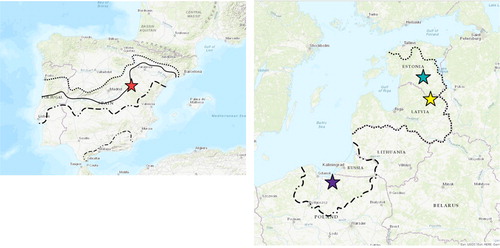
Figure 1. The medieval geo-political context of the Baltic Ordensland: Livonia (broadly present-day Estonia and Latvia) and Prussia, showing their borders respectively in circa 1450 and circa 1400, and of Iberia: al-Andalus. The second map shows the successive frontiers of al-Andalus during the so-called Reconquista, from before 1031 (the northernmost dashed line) through circa 1086 and circa 1150 to (the southernmost dashed line) circa 1238. The coloured stars on both maps mark the location of the four castles most-discussed in the text: Karski (green), Cēsis (yellow); Elblag (purple) and Molina de Aragón (red). (Source: Guillermo García-Contreras Ruiz).
As a concept, the term ‘landscape’ can define a geographical area or tract of land, an assemblage of ecosystems in mutual interaction, and in cultural terms as a person’s perception of their physical world (Hoffman Citation2014). The ESF/COST Science Policy Briefing Landscape in a Changing World and the European Landscapes Convention share the view of landscape being ‘not simply the environment, but the world “as being perceived be people”, or the environment’s human element’ (Council of Europe Citation2000; ESF/COST Citation2010). If the concept of landscape is considered as a major force for social and environmental change or continuity, as the ESF briefing suggests, then European castle landscapes embody these forces. Landscape in a Changing World also sets the agenda for future integrated landscape research.
This paper seeks to reconnect castles with their landscapes through the application of geoarchaeology, which applies earth science techniques, such as soil micromorphology and physio-chemical analyses, to archaeological research questions. Geoarchaeological techniques can be applied to create synergies between the buried archaeology of castles with sediments from their historical territories or hinterlands and between the cultural and natural heritage. They allow the preservation conditions of buried archaeological deposits to be assessed to inform heritage management decisions (Canti and Huisman Citation2015), but also provide important taphonomic information, when used with other sources of environmental evidence, such as faunal remains, plant macro-remains, and palynological studies (Banerjea et al. Citation2020a), to reconstruct the history of land use within a castle’s hinterland (Brown et al. Citation2015; Stivrins et al. Citation2015; Citation2019). Geoarchaeology can also aid the interpretation and presentation of castle landscapes within their formal management structures and inform future research frameworks and practice.
The castles discussed here, as elsewhere in Europe, have been the focus of many surveys and excavations, and have long-represented important historical narratives. From a heritage perspective, however, they have largely been disconnected from their associated historical territories. We argue that the links between on-site activities and those in the hinterland that are revealed by geoarchaeological research are important in defining the castle landscape itself from both a scholarly and a heritage perspective, and for presenting the past to the public in ways that are relevant for the future identity of these iconic monuments. Our research underlines the importance of incorporating the hinterland into management decisions for the standing remains, while situating these decisions within the political context of heritage legislation, particularly exploring their role in the creation of heritage narratives and identity politics, such as ethnic nationalism. This is visible elsewhere in Europe, such as in post-Soviet Croatia where castles form part of a national identity emphasising resistance to outsiders (Harrison Citation2013), but it is particularly emphatic in the case of historical frontier regions in which castles are iconic monuments of ideologically driven conflicts, power relations and processes of colonisation during a formative period in European history (Bartlett Citation1993). These conflicts have been appropriated within modern politics and steer heritage management decisions and research frameworks.
Political considerations in policy development
In Poland and Spain, medieval castles are embedded within complex geopolitical contexts and nationalist agendas, and, as such, have been viewed as symbols of authoritarian and/or colonising regimes. In the eastern Baltic, the crusades waged against native pagan societies for almost a hundred years resulted in their disenfranchisement and the reorganisation of the conquered territories into the two Christian polities of Livonia and Prussia, both dominated by the Teutonic Order (Pluskowski et al. Citation2018; Pluskowski Citation2019a). In former East Prussia, the Teutonic Order’s castles were one of the key elements in building national and state identity, and during and after World War II, the Teutonic Order became synonymous with German militarism (Pluskowski Citation2012). Once Prussia had been partitioned between Poland, Lithuania and the Soviet Union, these castles became unwanted, foreign heritage. This was also the case in Latvia during both its interwar period of independence and the following five decades of Soviet occupation.
In Estonia, however, research in the folklore archives of the Estonian Literary Museum in Tartu by one of the present authors (Valk) suggests that despite a history of German and Soviet occupations, perceptions of these monuments differ. Castles are not connected to medieval German militarism but are simply ruins from the past, a part of the local cultural landscape. Memories of castles are quite vague: castles are only briefly noted as destroyed in wars, connected with ‘Swedish time’ (which ended between 1704/1710 in Estonia, the Swedes being the last political power to possess castles, or being associated with romantic legends about knights.
In Poland, the perceptions of the Teutonic Order’s striking red brick castles—and the cultural heritage of former East Prussia more widely—was the result of Poland’s ‘Third Partition’ of 1795-1797, the aftermath of World War I and, above all, the trauma of World War II. For this reason, it has been problematic in Poland to consider castles regarded as ‘German’ as National Heritage. Even so, Teutonic Order castles were protected under Polish law as monuments as early as the late 1940s, initially until 1962 by pre-war Polish law that protected state-owned monuments, and thereafter by laws of 1962 and 2003. In 1989, however, the ownership of castles was transferred from the national state to local governments and private individuals. The heavy financial obligation rested primarily on local governments and private owners, and led many municipalities to sell castles to private owners, usually investors, and typically at a very low price. The law requires castle owners to finance archaeological excavations in the case of planned ground disturbance, which led to the excavation of castles by small private archaeological companies selected on the criterion of cost, rather than any research design.
There are some similarities in the management of castles in former Livonia (present day Estonia and Latvia) and Prussia (present day North-Eastern Poland and the Kaliningrad oblast of Russia), but also some differences. Some castles and castle sites in Latvia and Estonia are privately owned, but they are most often owned by the state or local municipalities, and castles and ruins preserved above ground are protected by the law. The importance of archaeology in the research of castles in Latvia and Estonia cannot be overestimated not only because most of the castles are ruins and some have no above ground remains (), but also because only a very limited amount of documentary records has survived; Prussian castles are associated with a relatively larger quantity of medieval written sources. Most castles are in ruinous states or have no above ground remains and across the eastern Baltic, some castles or their ruins were damaged or destroyed as a result of conflicts arising from German and Soviet occupations during the first and second World Wars. In Latvia and Poland the perception of castles as unwanted heritage, arising from these conflicts, has negatively impacted the extent to which they are the subject of research, except for large-scale rescue excavations in Latvia after 1960.
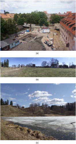
Figure 2. (a) Excavations in 2013 at the Castle Museum, Elbląg, Poland (photograph Archaeology and History Museum, Elbląg), in the area that was the outer bailey of the Teutonic Order castrum; (b) The walls and gate of Karski castle, Estonia, its only standing remains (photograph Alex Brown); (c) Karksi castle from across the River Halliste (photograph Alex Brown).
It is a similar situation in Spain, where the Spanish Civil War impacted on perceptions and the preservation of castles as well as the extent of research, although again since 1960 there have been some larger excavations. A Spanish association for protecting medieval fortifications has a list of more than 10,000 fortifications across Spain, of which at least 3000 must be considered medieval castles (Schnell Citation2009). The ‘National Plan of Defensive Architecture’ drafted by the Spanish Cultural Heritage Institute, forms part of the national policy for Spanish historical heritage as far as information, preservation and restoration are concerned (Rodríguez Citation2014). The fragmented territorial model of the Spanish State results in the overlapping of different rules, legislation and permissions that affect research inside castles, despite efforts at cataloguing and protection from the central government (Carrión Citation2015). The complicated, heterogeneous and fragmented situation is the legacy of the Franco regime and its law of 1949 which placed all castles under legal protection as national Spanish heritage, with an ‘architect-curator’ in charge of conservation (López-Muñiz Citation2017). All fortifications were immediately designated in this way, but in practice only the castle’s architecture was protected by heritage management officials and regional legislators, and the provision of specific and integrated research agendas and management strategies became difficult.
Researchers have traditionally focused on the fortified architecture of the late Middle Ages due both to the preference for rammed-earth constructions during the Islamic period, which causes difficulties with conservation and identification, and to the place of the idea of the Christian Reconquista in the founding discourse of the Spanish nation and its heritage (Moreno Citation2016). With very few exceptions, most regional studies concern monumental and defensive architecture and their integration into analyses of the settlement pattern (e.g. Palacios Citation2019, 442–444). This perception of castles as an expression of the successful political and cultural imposition of Spanish culture onto the previous Islamic polity has affected the type of archaeological research carried out on these monuments (Palacios Citation2019), causing a focus that is still largely (despite recent development in methods, concepts and themes) on defensive architecture rather than on questions relating to daily life, procurement and provisioning of raw materials, or how their construction and modifications impacted on the surrounding landscapes (Valor and Guiérrez Citation2014, 148–175). There is a similar architectural focus to castle research in Poland, initiated by Kajzer (Citation1996, 139–148) and elsewhere in Europe. In the United Kingdom, despite the upsurge in research on the social and landscape contexts of castles, English Heritage's (now Historic England’s) Regional Research Frameworks have still tended to subsume castles under the heading ‘Defence and Warfare’ (Creighton Citation2009).
In both the eastern Baltic and Spain there is no specific legislation for managing or protecting a castle’s landscape. In Estonia and Latvia protected monuments are surrounded by ‘protection zones’ where development and activities are regulated, and these can include the protection of views and landscapes. Recent laws—Estonia’s Heritage Protection Act 2019 and Poland’s 2003 Act ‘on the protection and care of monuments’—include some general principles for protecting cultural landscapes but essentially remain guidelines and generic ideals, a striving towards a ‘new thinking’ that still awaits translation into practice. In Poland, geoscientific approaches have focused primarily on examining the geomorphological conditions for a castle’s location in the landscape. In Spain, castles are studied from the perspective of architecture and traditional approaches to the study of material culture (ceramics, metal artefacts and in a few cases faunal or plant remains), but the heritage law of the Franco regime did not apply to the buried archaeology.
Life-histories of castles and the value of buried deposits
The ‘life-history’ or biography of a building or monument refers to the dynamic chronologies of its establishment, development, architectural modification, abandonment and post-abandonment, as well as its diachronic use. It is most effectively examined using a geoarchaeological approach to interpret formation processes at high resolution (e.g. Banerjea et al. Citation2015, Citation2017, Citation2020b, Citation2020c; Borderie et al. Citation2020), but until very recently such research has been rare. Soils within profiles or unexcavated areas in and around monuments have been investigated only infrequently, and without a specific geoarchaeological research focus, except to assess the geological and geomorphological aspects for military strategies in castle location (Mariani et al. Citation2019). Geoarchaeology has been applied in only three published studies, of Juslibol (Zaragoza), Alfama (Teruel) and Castillejo de los Guájares (Granada), but in all three cases, as in Poland, their focus is more on geomorphology than buried archaeology (Burillo et al. Citation1981; Peña-Monné et al. Citation2014; Forlín and Gerrard Citation2017). Recent micromorphological research in Molina de Aragón, Guadalajara (Banerjea et al. Citation2020b) and within the ‘Landscapes of (Re)Conquest’ research project (García-Contreras Ruiz et al. Citation2020) has however pioneered the application of geoarchaeological approaches, particularly soil micromorphology, to castle landscapes in Spain.
The potential of geoarchaeological analysis at castle sites is thus beginning to be realised (Banerjea Citation2019; Banerjea and Badura Citation2019; Banerjea et al. Citation2020a,Citationb; Borderie et al. Citation2020; Brandolini et al. Citation2018) and in what follows, its benefits and value is demonstrated through stages in the life-histories of four castles in the Baltic and Iberia, at Elbląg, Karksi and Cēsis in the Baltic and Molina de Aragón in Spain. Geoarchaeological approaches to classify construction materials according to composition and production techniques, and to identify source materials with a view to providing chronological phases for the standing remains, are applied to understand the development of monuments and the acquisition of materials (Hayward Citation2019), or for conservation purposes (Gutierrez-Carrillo et al. Citation2019).
Excavated sequences at Elbląg, Poland, and Karksi, Estonia contained well-preserved, well-stratified and semi-waterlogged deposits with exceptional preservation of organic remains (for full micromorphology results see Banerjea Citation2019; Banerjea and Badura Citation2019; Banerjea et al. Citation2020a). The sediments at the base of the profile at Karksi were deposited rapidly between A. D. 1266 and 1290 (Brown Citation2019a). Timbers at the base of the deposit sequence from Elbląg produced a dendrochronological date of A. D. 1245 (Fonferek Citation2019) and is one the earliest dated Teutonic Order timber castles in Poland. The sequence not only represents the very earliest occupation and use of the outer ward, but also provides a unique insight into castle function and use in the early years of Teutonic Order’s rule. The microstratigraphic investigations, augmented by integrated macro- and micro-botanical proxies, showed local clearance activities (Karksi), in situ evidence for animal husbandry and livestock alimentation (both sites), refuse remains from middening activities (Karksi) and the destruction of the timber castle (Elbląg).
Excavations at Elbląg in 2012 and 2013 not only confirmed the militaristic character of the site, but also contributed valuable information on the provisioning and storage systems of the early castle (Fonferek Citation2019). Geoarchaeological analysis of the profile from the 2013 excavation (Banerjea et al. Citation2020a) revealed that the outer ward of the early castle was first used to keep small herbivores, probably sheep or goats, then to stable larger herbivores, which, on the basis of the horse furniture recovered during excavation and documentary evidence relating to the use of the outer bailey of Teutonic Order castles, were probably war horses. The sequence showed regular flooding events, attested by depositions of alluvial sediment, including before the destruction of the timber stronghold prior to rebuilding in stone. The Old Town of Elbląg, is located on the River Elbląg. In the present day, the city is a port on the river, which flows into the freshwater Vistula Lagoon, from where the Strait of Baltiysk gives passage to Baltic. In 2012, geological and palaeoecological investigations of sediments which underlie the courtyard of the Museum of Archaeology and History in Elbląg documented the evolution of this area from a relatively deep lake, Lake Drużno, through a shallowing water body, to a waterside zone, where the River Elbląg flowed into the Vistula Lagoon, by the time the timber castle was erected (Nitychoruk et al. Citation2016). The soil profile obtained during excavation in 2013 (Banerjea et al. Citation2020a) show that the outer bailey of the timber castle flooded on several occasions. There appears to be evidence for a ‘brush wood’ platform being laid following one of these flooding events, prior to the use of the area to stable horses. It is plausible that the repeated flooding of this area by the River Elbląg was a reason why the area, which does not seem to have been incorporated into the new brick castle, was abandoned.
Geoarchaeological and palaeoecological evidence from Karksi, Estonia, revealed how the earliest inhabitants at the site modified the local environment and how areas of the site would have appeared during the construction of the castle (Banerjea et al. Citation2020a; Banerjea and Badura Citation2019). This new phase reflected the central role of castles in re-organising conquered tribal landscapes (Pluskowski et al. Citation2019a). The sediments at the base of one profile were overlaid by deposits that probably dated to the late fourteenth or fifteenth century, which formed below the first preserved pavement of the High Castle in which artefacts dating to the fifteenth century were recovered (Valk et al. Citation2012). Soil micromorphology defined the formation processes of the sequence during the thirteenth and fourteenth centuries. Analysis of the thirteenth century deposits show that livestock were stabled in the area that was to become the High Castle, prior to and during the removal of vegetation, probably for its construction, as evidenced by a reduction in tree pollen in the pollen record (Banerjea et al. Citation2020a). The clearance of vegetation provided leaf fodder for the animals. Microstratigraphic analysis (see Banerjea et al. Citation2020a) shows that a spring was dammed using redeposited clay to create a small pond as a watering hole for livestock, which also contained fish at one point, possibly used as a food source by occupiers during the construction of the castle. Midden material infilled the pond when it fell out of use. This was rich in artefacts and refuse, but only very few pottery sherds (Valk et al. Citation2012). It also contained plant macro-remains (Banerjea et al. Citation2020a), including traces of cereals (rye, barley, oat, wheat), strawberry seeds and hazelnut shells, charred wood, egg shell, fish bone, burnt and unburnt bone; fragments of coprolites belonging to small herbivores such as sheep or goat were also trampled into it. Microstratigraphic analysis of other deposits dating to the fourteenth century (see Banerjea and Badura Citation2019) showed that they formed in an external area and comprise poorly formed soils, trampled or frost-affected layers, and a levelling surface, which is overlaid by occupation deposits containing anthropogenic refuse and which could indicate a point when there is an intensification of activity from the newly built castle.
At Cēsis, our understanding of the development of the castle landscape has been increased by geoarchaeological analysis at three locations: the stronghold on Riekstu Hill, the outer bailey of the stone castle, and the eastern range (). Micromorphological methods were applied to examine potential destruction deposits associated with the earthwork and timber fortress of Riekstu Hill (see Banerjea and Badura Citation2019) to understand its composition, whether it consisted of multiple structures that were destroyed, or whether it represents multiple rebuilding and destruction events or a single event. The analysis examined the validity of the suggestion of religious assimilation and peaceful coexistence between the Teutonic order of the Brothers of the Sword and the Vends, who are documented as voluntarily converting to Christianity in 1206 (Banerjea and Badura Citation2019; Pluskowski et al. Citation2019b) and supports the hypothesis that Cēsis was a place of coexistence between the Vends and the Sword Brothers. Micromorphology shows that the timber fortification of the hillfort was only destroyed once, and that subsequent thin horizons containing charred material were formed because of erosion and trampling processes, rather than due to several destruction or burning episodes. The erosion and trampling events were interspersed with periods of surface stabilisation where pedogenesis began, which indicates periodicity in their formation. This shows that the timber structures were not repeatedly destroyed and rebuilt prior to the construction of the masonry fortifications on Riekstu Hill. The Order’s stone castle at Cēsis (Wenden) was begun (by the Brothers of the Sword) in 1218 and overlapped with the occupation of the adjacent the Vends’ stronghold on Riekstu Hill (Pluskowski et al. Citation2019b).
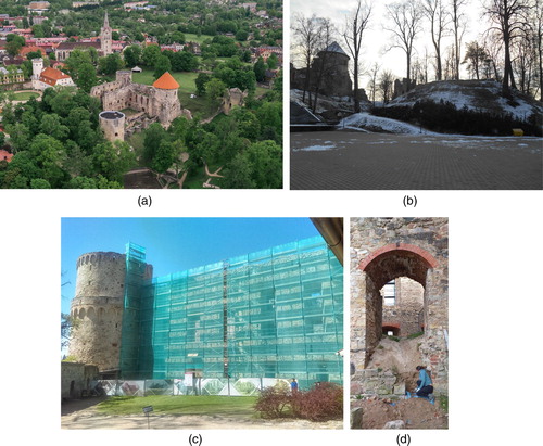
Figure 3. Cēsis castle, Latvia: (a) overview of the Teutonic Order castle, (b) Riekstu Hill, the pre-crusade stronghold adjacent to the Order’s stone castle, (c) south-east tower and exterior of the eastern range during conservation work, (d) excavation and sampling of the eastern range in 2019. (Photos: Rowena Y Banerjea, Alex Brown and Gundars Kalniņš).
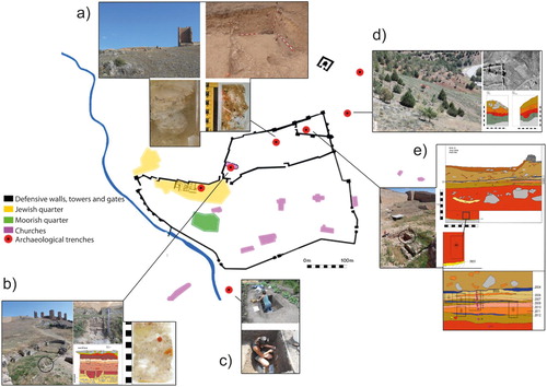
The occupation of a castle site can be dynamic. At Molina de Aragón, soil micromorphological data from profiles within the citadel and the church of Santa Catalina, or Cristo de las Murallas, dating from the twelfth century () show alternating periods of habitation occupation, abandonment and post-abandonment occupation (Banerjea et al. Citation2020b; García-Contreras et al. Citation2016). These microstratigraphic data show the changing nature of the occupation within this area of the citadel, from Islamic to Christian. Micromorphological thin-sections from samples from the citadel, collected from strata between a destruction deposit overlying the earlier Islamic floor and occupation, and post-medieval features such as a nineteenth century drain (Arenas Citation2008, 26 and 50) show a series of plaster floor surfaces with associated occupation residues containing herbivore dung; livestock were present in this area and the dung was also used as fuel. Units of discarded material and trampled floor surfaces (Banerjea et al. Citation2020b) represent the (Re)Conquest phase, c. 1154 (Arenas Citation2008), and are overlaid with a series of mortar and gypsum plaster floors (Banerjea et al. Citation2020b), probably related to modifications inside the courtyard during the thirteenth and fourteenth centuries (Arenas Citation2008). The other inclusions within these occupation residues represent domestic activities. This contrasts with the deposit below the destruction horizon, overlying the earlier probably eleventh century Islamic plaster floor (Arenas Citation2008), which contained very low abundances of occupation residues associated with domestic activities and suggests that the plaster floor below was cleaned regularly. The deposit overlying the floor plaster shows features of soil forming processes which indicate that this area was abandoned and left without a roof for some time prior to being covered with the thick deposit of destruction material. Experimental archaeological research has shown that in Northern Europe occupation deposits can turn to soil within 2.5 years after being left without a roof (Banerjea et al. Citation2015), but no such experiment has been conducted in a Mediterranean context.
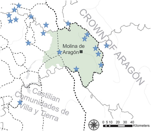
Figure 4. Molina de Aragón, Spain. Above (A) The boundaries of the County of Molina by the end of the Middle Ages. The blue stars indicate lakes and wetlands with potential for coring. The black square indicates the position of the Castle of Molina. Below (B) the Castle of Molina de Aragón showing (a) micromorphology sampling from the excavation in the outer ward in 2017; (b) micromorphology sampling from an exposed profile in the church of Santa Catalina or Cristo de las Murallas in 2015; (c) excavation and sampling in 2016 of a Christian extension of the irrigation system; (d) excavation through a pre-1950 terrace system—Islamic pottery was recovered from the terrace wall; (e) micromorphology sampling in 2015 from an exposed profile in the citadel (Sources: Upper—Guillermo García-Contreras Ruiz (after García-Contreras Ruiz et al. Citation2020)). Lower-Rowena Y Banerjea and Guillermo García-Contreras Ruiz (after García-Contreras Ruiz et al. Citation2016).
Agriculture and land-use
Buried archaeological deposits within castles can be related to the contemporaneous transformation of the associated landscape. Palynology has been crucial in reconstructing the vegetation and land-use changes associated with the impact of the Baltic Crusades, particularly at the regional scale, with geoarchaeology, arguably, playing a supporting, but important role in detecting more localised, immediate changes such as soil erosion and specific events relating to vegetation clearance and animal husbandry. Reliable chronologies are a fundamental part of palaeoecological reconstruction from lake and peat bogs (Brown et al. Citation2019). High resolution dating is particularly necessary in the medieval period; long pollen sequences covering several thousand years often lack the sample and chronological resolution required to resolve rapid or short-term changes in vegetation occurring at the sub-centennial to decadal scale (Brown and Pluskowski Citation2014). Although rotational farming was already present in north-western Estonia before the crusades (Pluskowski Citation2019b), in Livonia and parts of eastern Prussia, pre-Crusade agricultural practices survived for centuries and trade was not as well developed as elsewhere(Pluskowski et al. Citation2019a). Colonisation in the eastern Baltic (Livonia) was limited largely to the major urban centres such as Riga, where their establishment involved new concentration of people and animals (Banerjea et al. Citation2017; Brown et al. Citation2017), or key rural centres such as the Teutonic Order castle at Trikata, located on one of the main north–south roads through Livonia that probably held a key provisioning role (Stivrins et al. Citation2015; Citation2019). There was limited colonisation of the rural hinterlands, and native populations continued to follow indigenous patterns of land-use (Stivrins et al. Citation2015; Brown and Pluskowski Citation2020). In comparison with geochemical enrichments and macrobotanical evidence from middening activities in Riga during the thirteenth and fourteenth centuries, the data from sediments within the moat (mid-fourteenth century) and first bailey of the stone castle at Cēsis indicate quite a low intensity of occupation, without any large build-up of effluent and refuse as seen at Riga (Banerjea and Badura Citation2019).
Geochemistry and palynology can produce complementary datasets for reconstructing land-use around castles. Palaeoenvironmental data from Lake Araiši, eight km south-west of Cēsis, revealed that the most significant changes in vegetation and environment occurred between A. D. 780–1050 with the establishment and occupation of a Late Iron Age lake-dwelling, but that after the crusades the form and type of agriculture continued as it previously had. There is little evidence for increased land-use associated with the founding of the castle during the first half of the fourteenth century or with the subsequent post-medieval manor. Similarly, geochemistry shows an increase in Titanium (a reliable indicator of soil erosion and anthropogenic trace elements, Boyle Citation2001) which suggests Late Iron Age soil erosion and contamination from activities associated with a nearby castle of the Cēsis (Wenden) commandery (Stivrins et al. Citation2015).
At Radzyń Chełmiński, Poland, the close association between the lake, the stronghold occupied from the eleventh to the early thirteenth century, and the later fourteenth century castle and medieval town presents the ideal opportunity to reconstruct past vegetation and land-use dynamics within successive phases of archaeologically and historically documented phases of colonisation and land-use (Brown et al. Citation2015). Geochemical analysis of cores from the Castle Lake identified changes in the landscape associated with the earliest phase of land-use in the seventh/eighth century associated with Slavic colonisation. Geochemical analysis detected subtle land-use changes before they were observed in the standard pollen abundance record, and can reflect activity at a very local level in comparison with the palynological data (Brown et al. Citation2015), which is harder to identify due to the bias in tree pollen and its wider dispersal; a sharp peak in Titanium enrichment starting c. A. D. 750 represents soil erosion and a decrease in tree pollen from tree removal is not observed until A. D. 800–900. The modelled pollen data correct for this bias and show an increase in meadow land and cereals from A. D. 700 to 800 (Brown et al. Citation2019), which is consistent with the geochemical evidence for soil erosion.
In Spain, differences in climate (affecting pollen preservation) and agricultural practices give geoarchaeology a different role to play than in the eastern Baltic in understanding land use and landscape management such as terracing associated with castles in this region. Palynological studies in Spain have to date been conducted primarily on peat bogs and lakes located in mountainous landscapes at mid- to high-altitude, with the aim of investigating long-term Holocene vegetation history, climate and human activity (e.g. Hernández-Beloqui et al Citation2011; López-Sáez et al Citation2012; Moreno et al Citation2012; Blanco-González et al Citation2015; García-Ruiz et al Citation2020). Although there are a significant number of palaeoenvironmental studies from Spain, with a notably concentration in the Spanish Central System, the chronological resolution is usually insufficient to provide a nuanced interpretation of medieval land-use and vegetation change at the sub-centennial scale appropriate for comparison with the historical and archaeological record, as undertaken in the Baltic. For example, Castro et al. (Citation2020), discussing the Late Iron Age period and medieval climatic optimum, report 22 radiocarbon dates, but only five for the last 2000 years. Many sequences have one or two radiocarbon dates corresponding to the medieval period, or none at all. This is not intended as a criticism of existing palynological research, but rather an observation that a focus on the medieval period requires a higher chronological resolution than is available in many cases.
The data from these mid- and high-altitude pollen studies suggest a varied picture of vegetation change and human activity occurring in the context of important climate and cultural changes (e.g. López-Merino et al Citation2009; López-Sáez et al Citation2012; Moreno et al Citation2012; Morellón et al Citation2012; Corella et al Citation2013; Blanco-González et al Citation2015; Luelmo-Lautenschlaeger et al Citation2018; Broothaerts et al Citation2018; Morales-Molino et al Citation2018). However, these studies are typically located towards the margins of occupation, associated with patterns of transhumance or specific resource exploitation, and their results are biased away from the lowland landscapes where settlement was concentrated.
Whilst there have been geoarchaeological investigations into the evolution of arid and semi-arid agriculture associated with medieval rural settlements in several areas in Spain, including Murcia (Puy and Balbo Citation2013; Puy Citation2014), Galicia (Ferro-Vázquez et al. Citation2014) and the Basque country (Quirós Castillo et al. Citation2014; Quirós Castillo and Nicosia Citation2019), castles are rarely included within studies of the different agrarian landscapes in Iberia (for discussion of these see Glick Citation1995; Malpica Citation2014; Quirós Citation2013). They are, however, recognised as central points in the distribution of settlements. In al-Andalus, they have been studied as refuges for peasants, fortified granaries or administrative centres; during their Christian phases, their political and military roles are studied. In neither case are castles or their inhabitants explicitly attributed a proactive agency in shaping and transforming the surrounding landscape. This is one of the aims of the new ‘Landscape of (Re)Conquest’ research project (García-Contreras Ruiz et al. Citation2020) where the geoarchaeological sampling strategy at Molina de Aragón encompasses areas within the castle, adjacent terraces and irrigation system ((B)). Palynological studies will be conducted as part of this project, but the lakes and wetlands from which cores will be taken, are situated outside of the valley of Molina ((A)).
Presenting castle landscapes
In the castle landscape, monuments can be related to historically defined territories, and particularly in the eastern Baltic, with sacred landscapes (Pluskowski et al. Citation2018, Citation2019c). In Iberia, the castle landscape is synonymous with a shift in the overall pattern of rural settlement (Pluskowski et al. Citation2011). In the eastern Baltic, many castles only survive as ruins or have no above ground remains, which poses the question as to what extent ruins should be considered ‘a castle’? Thus, the protection of castle landscapes is regulated by different general principles depending on type and level of survival.
The castle landscape can be articulated as a ‘heritagescape’ (Garden Citation2006). The term offers a common language to examine heritage sites, and a coherent methodology to analyse them, both as individual places and in terms of their relationship to other heritage sites. While it is an established ontology, ‘heritagescape’ continues to be revisited as a springboard for articulating new ways of preserving, protecting (Lopes et al. Citation2019) and promoting (Penrose Citation2020; Burlingame Citation2019) heritage, and as a basis for developing analytical, interpretive and operational models in tourism (Fagence Citation2014). A ‘heritagescape’, like any other landscape, is the set of individual components that, together, create a particular place. Whilst heritagescape incorporates some of the basic constructs of landscape theory, it is a particular idea that relates wholly to heritage sites. The framework of administrative protection such as that of a UNESCO Geopark provides a wider context in the ethnographies of particular heritage and/or tourism sites, or for particular countries’ or regions’ tourism development endeavours linking both natural and cultural values (Di Giovine Citation2009). A Geopark has a formal structure that can create and maintain interdisciplinary understandings of the landscape.
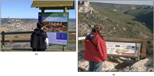
In that sense, by using geoarchaeological and other palaeoenvironmental proxies, links between the heritage site (i.e. the standing remains of the castle) and other related sites and features in the landscape (such as, at Molina de Aragón, the activities within the castle and those on associated terraces and irrigation systems) can be more effectively demonstrated, linking landscape research with policy, practice and knowledge exchange (). In the research framework of a ‘castlescape’, these should be investigated and presented together in future signage, rather than separately, with interpretations beyond a focus on the geomorphological context of archaeological sites (). For a site such as Molina de Aragón, the presentation of the development of the castle and the history of its territory can be synergised with the geoheritage of the Molina and Alto Tajo UNESCO Global Geopark (Saiz et al. Citation2015) thus linking geological heritage and all other aspects of the area’s natural and cultural heritage and enabling the creation of geo-educational itineraries of the landscape (Brandolini et al. Citation2019), fundamental features of a Geopark.
Figure 5. Molina de Aragón, Spain: Visitor information board, currently present the information about the castle (a) and its landscape (b) in an unintegrated fashion on two separate explanatory boards (almost 30 km apart). (Photos: Manolo Monasterio, Director of Geoparque de la Comarca de Molina de Aragón-Alto Tajo and Museos de Molina.).
For historical landscapes, collaborations between physical sciences, humanities and social sciences can be more effective in connecting landscape research with policy and practice. Geo-educational itineraries for the ‘castlescape’ within a Geopark, which is arguably an ideal setting, can provide models that can borrowed by castle museums and visitor centres outside of a Geopark. Such itineraries can be integrated into heritage trails and cultural routes that include castles such as the Hansa network (a Council of Europe ‘Cultural Route’) that includes Cēsis Castle. Geoarchaeological and palaeoenvironmental research enables stories within the soils to be told: stories about contested pasts, some of which still provoke an emotional response, and stories about other aspects of cultural identity such as food and wine tourism (Metro-Roland and Soica Citation2019), where soils play an important role in past, present and future production.
The county of Molina, a long-established historical territory in central Spain (), provides an exceptional opportunity for investigating the heritage of the dynamics of frontiers, colonisation and social reorganisation during the Middle Ages. Over several centuries, political control of the territory fluctuated: first part of an Islamic polity (A. D. 711- 1128) and subsequently of various Christian authorities (first a semi-independent lordship linked to the Castilian crown under the rule of the Lara Family, a short period within the Kingdom of Aragon, A. D. 1366 - 1375, and thereafter a part of the Crown of Castile (Estepa Citation2006, García-Contreras et al. Citation2016). The centre of power in the region consisted of a fortified hilltop complex in one of the principal mountain ranges in Iberia. The different phases of evolution of the main fortification are directly related to landscape changes identified across its territory, and to the spectrum of cultivated fields, mines, quarries or forests that were exploited. All this is evident from analysis of both the raw materials used in the standing architecture and the buried archaeology, and from spatial analysis using GIS with contributions from geoarchaeology, from soil micromorphology to palynology. On the other hand, the institutions in charge of managing both natural and cultural heritage are based in the territory's own capital.
As discussed above, geoarchaeological analysis in castles has successfully demonstrated how inhabitants of castle sites began to modify their local environment and adapt and manage it. At Karksi, Estonia, for example geoarchaeological evidence shows clearance of birch vegetation prior to the construction of the High Castle and the damming of a spring to create a small pond-cum-watering hole for livestock; at Elbląg, Poland it has been shown how inhabitants responded to repeated flooding of the outer bailey. Such analyses also provide snap-shots of how different areas of the castle landscape looked at specific points in time by revealing change through time, activities within different spaces, areas of abandonment and reuse and interactions with wider agricultural practices by understanding what livestock were kept in the castle, where and how they were fed. A modern visitor to these castles might well see these spaces as blank areas, yet geoarchaeology provides information to colour these areas and enhance their visibility within and a wider castle landscape and heritagescape.
‘Heritage’ itself has very little to do with the past, and its practice should fundamentally be concerned with assembling and designing the future though dialogue; thus cultural heritage conservation could become part of a broader environmental agenda (Harrison Citation2015). The scientific importance of palaeosols (French Citation2003) is not novel in archaeology. However, their protection as cultural and geoheritage (Costantini and L’Abate Citation2009) and their potential for informing dialogues in the interpretation of cultural landscapes (Conway Citation2010) is a concept which is starting to gain some momentum (Messaeroli et al Citation2020; Garrido Machado Botelho Citation2020) For example, in the UK, sediment profiles can be highlighted as a ‘Site of Special Scientific Interest’ (SSSI) and a Geopark provides an obvious administrative framework in which to highlight soil and sediment profiles to be protected as palaeoenvironmental archives of cultural scientific potential, arguably an ‘in situ’ archive (Penrose et al. Citation2020). With the recognition that ‘change and transformation has been reframed as an integral element of heritage’ (DeSilvey et al. Citation2020, 360), it is not argued here that castle landscapes (or any cultural landscapes) are frozen in time, but where under threat, the potential of soils and sediments is explored and they are geoarchaeologically investigated. Soils, sediments and stratigraphy are the backbone of the archaeological record, yet geoarchaeological techniques to investigate them still remain underused resources (Goldberg Citation2008; Goldberg and Aldeias Citation2018).
Geoarchaeological data from a castle landscape can illustrate historic processes such as anthropogenic pollution and localised soil erosion (e.g. Brown et al. Citation2015), and better understand the formation, use and erosion of abandoned terraces and thereby inform appropriate conservation (Bevan and Conolly Citation2011; Stanchi et al. Citation2012). When castles and landscapes are adapted or repurposed, modern owners or users would benefit greatly from the type of information that can be gained from prior geoarchaeological and palaeoenvironmental examination of the onsite soils, sediments and features (such as agricultural terraces) that lie beyond the monument but are still part of the castlescape. A detrimental, but fortunately isolated, example of the lack of such prior research is the Teutonic Order’s castle in Giżycko (formerly Lötzen), where the transformation of the castle into a hotel in 2009–2011 without any archaeological investigations, led to the original castle buildings and their surroundings being covered by a new structure stylised as Gothic architecture, and arguably to the devastation of a historical castlescape. Today, the new buildings are often considered by tourists as a ‘stylishly restored’ castle (Pluskowski Citation2012, 355, 364).
Conclusion
Garden (Citation2006) argues that a ‘heritagescape’ should have clearly defined boundaries and we argue that for a castle’s ‘heritagescape’ those boundaries should encompass its hinterland, or its landscape, which in the case of the Teutonic Order’s castles in the eastern Baltic, for example, is the extent of their districts, and for a castle such as Molina de Aragón is its dynamic territory defined by multiple shifting frontiers. Geoarchaeology creates synergies between on-site and off-site environments and between cultural and natural heritage, and thus enables proper understanding of such large and extensive complexes. Soils and sediments are the backbone of the archaeological record and contain valuable information about the changing form and function of castles and associated land-use. These narratives ought to play a pivotal role in the creation of joint studies using historical, archaeological and heritage approaches for the conservation and management practice of castles and landscapes. The ‘castlescape’ is a particular type of ‘heritagescape’, often with many buildings, such as towers, associated with the castle, with a range of spaces within the castle each with their own complex life-histories, and with extensive territories beyond the castle, such as agricultural systems. The boundaries of hinterlands, and frontiers around the castle, can be fluid and so the presentation and management of the castle landscape should accommodate this.
The abstract concept of ‘castlescape’ is not a physical dimension that could be measured in basic cartesian terms, but rather represents an effort to situate fortified sites within the context of their broader landscapes and environments, not only in terms of visual space or their economic catchment area but also in relation to their role in the reconfiguration of territories, land-use and settlement patterns both in the past and present. This requires the integration of both on-site and off-site perspectives when considering an individual site’s heritage. In summary, the castlescape is the cultural landscape associated with the biography of the castle. For this reason, there is no single model which can serve as a template for every castle; instead, it is important to begin with the specifics of each site. This highlights the value of local, biographical studies alongside broader, regional and inter-regional approaches.
In this regard, the papers in the special issue on ‘Forgotten Castle Landscapes’ of which the present paper is part, present many case studies for linking castle landscapes with heritage management. They range from embedded, active museum engagement with a range of research strands (Runge Citation2021), to castles at risk from climate change (Kerr Citation2021), to the challenges of presenting castle landscapes to the public (Bizri et al. Citation2021), and to the challenges of conducting landscape research on urban fortifications (Borderie et al. Citation2021). These cases show that palaeoenvironmental investigations should of course be embedded within research project designs for castlescapes at the planning stage, rather than as an afterthought; such integration of palaeoenvironmental data with survey and museum engagement will not only enrich our understanding of castle landscapes, but can bring them to life for a broader audience, and inform management decisions regarding what is heritage at risk and how to investigate it.
Acknowledgements
A workshop at the University of Reading in September 2019 as part of the project ‘All Along the Watchtowers! Balancing Heritage Protection, Development, and Scientific Research on Buried Archaeology at European Castles’ funded by the British Academy (Grant no. SRG18R1, PI Banerjea) provided the impetus for this paper and we thank all participants for their contributions. This project also supported preparation of materials from Molina de Aragón and fieldwork at Cēsis in 2019. Research at Molina de Aragón has been supported by the AHRC ‘Landscapes of (Re)Conquest’ project (Grant no. AH/R013861/1, PI Pluskowski, Co-PIs García-Contreras Ruiz and (Michelle) Alexander), the University of Reading, UK, research fund (2015), IMAGINE, University of Reading (2017), Society of Antiquaries of London (2017, PI Pluskowski), and the Council of Molina de Aragón, Guadalajara, Spain (2017, PI García-Contreras Ruiz). Research at Elbląg, Cēsis and Karksi was carried out within the framework of ‘The Ecology of Crusading’ project (2010–2014) and supported by the European Union’s Seventh Framework Programme, FP7/2007-2013 (Grant no. 263735, PI Pluskowski).
Disclosure statement
No potential conflict of interest was reported by the author(s).
Notes on Contributors
Rowena Y. Banerjea is a Researcher at the University of Reading (UK) in geoarchaeology, formation processes of the archaeological record, and frontier landscapes in medieval Europe. Rowena worked as Forum Coordinator to establish the National Heritage Science Forum (2011–2013) under the auspices of the Centre for Sustainable Heritage, University College London (UK).
Guillermo García-Contreras Ruiz is Senior Lecturer at the Universidad de Granada (Spain) where he teaches Medieval and Postmedieval Archaeology. He is specialist in Islamic Archaeology, Landscape Archaeology and settlement patterns in relation with natural resources exploitation. Currently he is Co-PI of the international project ‘Landscapes of (Re)conquest’.
Gundars Kalniņš studied history at the University of Latvia and graduated from the University of Leicester (UK) where he acquired a MA degree in Archaeology and Heritage. Since 2005, he has worked at Cēsis Museum where he is responsible for the conservation, research and interpretation of the Cēsis Castle.
Maciej Karczewski is Associate Professor at the University of Białystock (Poland). His research interests include settlement and environmental archaeology of the southeast Baltic in the 1st-15th centuries from a multidisciplinary perspective. His research also covers historical archaeology, especially the archaeology and heritage of WWI, and the history of archaeology and archaeological museology in the areas of Poland, Lithuania, Belarus, and former East Prussia.
Aleks Pluskowski is Associate Professor of Medieval Archaeology at the Department of Archaeology at the University of Reading, UK. His research focuses on the relationship between nature and culture in medieval Europe, particularly within frontier societies associated with crusading, colonisation, cultural encounters and religious transformations. He is currently the PI of the ‘Landscapes of (Re)conquest’ project.
Heiki Valk is a lead researcher at the University of Tartu, Estonia. His research concerns the final stage of the Iron Age, the time of the Baltic crusades and the later medieval period in the Eastern Baltic region. The main research interests concern hillforts, as well as social and cultural aspects of the archaeological record.
Alexander Brown is Principal Geoarchaeologist at Wessex Archaeology (UK) and a visiting academic at the University of Reading (UK). His research uses palaeoecology to investigate vegetation and land-use change, particularly associated with the conquest and colonisation of European medieval frontier landscapes. His research also includes woodland history and wetland and intertidal geoarchaeology.
Additional information
Funding
References
- Arenas Esteban, J. A. 2008. El patrimonio arqueológico del señorío de Molina. In Actas del segundo simposio de Arqueología de Guadalajara, eds. E. García-Soto, M. A. García Valero & J. P. Martínez Naranjo, Centro de Profesores de Sigüenza, 17–54.
- Banerjea, R.Y. 2019. Settlement life in Prussia at the microscopic scale and the impact on the hinterlands. In The Environment, Colonization and the Crusader States in Medieval Prussia and Livonia: Terra Sacra 1, ed. A. Pluskowski, Brepols, 405–424.
- Banerjea, R.Y. and Badura, M. 2019. Settlement life in Livonia and the impact on the hinterlands: the geoarchaeological and archaeobotanical evidence. In A. Pluskowski (ed) The Environment, Colonization and the Crusader States in Medieval Prussia and Livonia: Terra Sacra 1, Brepols, 175–206.
- Banerjea, R. Y., Badura, M., Brown, A., Morandi, L. F., Marcinkowski, M., Valk, H., Ismail-Meyer, K. and Pluskowski, A. 2020a. Feeding the Crusades: archaeobotany, animal husbandry and livestock alimentation on the Baltic frontier. Environmental Archaeology 25 (2), 135–150.
- Banerjea, R. Y., Badura, M., Kalējs, U., Cerina, A., Gos, K., Hamilton-Dyer, S., Maltby, M., Seetah, K. and Pluskowski, A. 2017. A multi-proxy, diachronic and spatial perspective on the urban activities within an indigenous community in medieval Riga, Latvia. Quaternary International 460, 3–21.
- Banerjea, R. Y., Bell, M., Matthews, W. and Brown, A. 2015. Applications of micromorphology to understanding activity areas and site formation processes in experimental hut floors. Journal of Arch. and Anth. Sciences 7 (1), 89–112.
- Banerjea, R., García-Contreras Ruiz, G. and Pluskowski, A. 2020b. Molina de Aragón, Guadalajara, Spain: archaeological soil micromorphology data from pilot projects in 2015 and 2017. figshare. Dataset. https://doi.org/10.6084/m9.figshare.12043248.v1.
- Banerjea, R. Y., Morandi, L. F., Williams, K. and Brunning, R. 2020c. Hidden husbandry: disentangling a disturbed profile at Beckery Chapel, a medieval ecclesiastical site near Glastonbury. UK: Environmental Archaeology.
- Bartlett, R. 1993. The making of Europe: conquest, colonization and cultural change 950-1350, Penguin
- Bevan, A. and Conolly, J. 2011. Terraced fields and Mediterranean landscape structure: An analytical case study from Antikythera, Greece. Ecological Modelling 222, 1303–1314.
- Bizri, M., Jouanin, G., Borderie, Q., Perrault, C., Save, S. and Vaughan-Williams, A. 2021. Connecting the medieval castle of Gien to its landscape: faunal, environmental and buildings analyses (Loiret, France). Landscapes 20.2.
- Blanco-González, A., López-Sáez, J. A., Alba, F., Abel, D. and Pérez, S. 2015. Medieval landscapes in the Spanish Central System (450–1350): a palaeoenvironmental and historical perspective. Journal of Medieval Iberian Studies 7, 1–17.
- Borderie, Q., Acheré, V., Lecroère, T., Labat, O., Capron, F., Pinhède, A., Louis, A. and Douard, M. 2021. Castles in Townscapes: Studying fortified medieval towns and their environments in Eure-et-Loir (France). Landscapes 20.2.
- Borderie, Q., Ball, T., Banerjea, R., Bizri, M., Lejault, C., Save, S. and Vaughan-Williams, A. 2020. Early Middle Ages houses of Gien (France) from the inside: geoarchaeology and Archaeobotany of 9th–11th c. floors. Environmental Archaeology: The Journal of Human Palaeoecology 25 (2), 151–169.
- Boyle, J. F. 2001. Inorganic geochemical methods in palaeolimnology. In Tracking Environmental Change using Lake Sediments. Volume 2: Physical and Geochemical Methods, Eds. W. M. Last and J. P. Smol, Kluwer Academic Publishers, 83–141.
- Brandolini, F., Trombino, L., Sibilia, E. and Cremaschi, M. 2018. Micromorphology and site formation processes in the Castrum Popilii Medieval Motte (N Italy). Journal of Archaeological Science: Reports 20, 18–32.
- Brandolini, F., Cremaschi, M. and Pelfini, M. 2019. Estimating the potential of archaeo-historical data in the definition of geomorphosites and geo-educational itineraries in the Central Po Plain (N Italy). Geoheritage 11, 1371–1139.
- Brown, A. D. 2019a. Vegetation changes in Livonia: The palynological data. In The Environment, Colonization and the Crusader States in Medieval Prussia and Livonia: Terra Sacra 1, ed. A. Pluskowski, Brepols, 105–136
- Brown, A. D. 2019b. Vegetation changes in Prussia: The palynological data. In The environment, colonization and the crusader states in medieval Prussia and Livonia: Terra Sacra 1, ed. A. Pluskowski, Brepols, 256–293
- Brown, A., Banerjea, R. Y., Wynne, A. D., Jarzebowski, M., Stivriņš, N., Shillito, L.-M. and Pluskowski, A. 2015. The ecological impact of conquest and colonization on a medieval frontier landscape: combined palynological and geochemical analysis of lake sediments from Radzyń Chełminski, northern Poland. Geoarchaeology: an International Journal 30, 511–527.
- Brown, A., Badura, M., King, G., Gos, K., Cerina, A., Kalnina, L. and Pluskowski, A. 2017. Plant macrofossil, pollen and invertebrate analysis of a mid-14th century cesspit from medieval Riga, Latvia (the eastern Baltic): Taphonomy and indicators of human diet. Journal of Archaeological Science: Reports 11, 674–682.
- Brown, A. and Pluskowski, A. 2020. Power centres and Marginal landscapes: Tracking Pre- and post-conquest (late Iron Age and medieval) Land-Use in the Cēsis Castle hinterland, central Latvia. Environmental Archaeology: The Journal of Human Palaeoecology, Available Online.
- Brown, A. and Pluskowski, A. 2014. Medieval landscape transformation in the south-eastern and eastern Baltic: palaeoenvironmental perspectives on the colonization of frontier landscapes. Archaeol. Baltica 20, 24–46.
- Brown, A., Poska, A. and Pluskowski, A. 2019. The environmental impact of cultural change: palynological and quantitative land cover reconstructions for the last two millennia in northern Poland. Quaternary International 522, 38–54.
- Broothaerts, N., Robles- López, S., Abel-Schadd, D., Pérez-Díaz, S., Alba-Sánchez, F., Luelmo-Lautenschlaeger, R., Glais, A. and López-Sáez, J. A. 2018. Reconstructing past arboreal cover based on modern and fossil pollen data; a statistical approach for the Gredos Range (Central Spain). Review of Palaeobotany and Palynology 255, 1–13.
- Burillo Mozota, F., Gutiérrez Elorza, M. and Peña Monne, J. L. 1981. El cerro del castillo de Alfambra (Teruel). Estudio interdisciplinar de geomorfología y arqueología. Kalathos 1, 7–64.
- Burlingame, K. 2019. Presence in affective heritagescapes: connecting theory to practice. Tourism Geographies, doi:10.1080/14616688.2019.1696882.
- Canti, M. and Huisman, D. J. 2015. Scientific advances in geoarchaeology during the last twenty years. Journal of Archaeological Science 56, 96–108.
- Carrión Gútiez, A. (ed.) 2015. Plan Nacional de Arquiecura Defensiva, Miniserio de Educación, Cultura y Deporte.
- Castro, D., Souto, M., Fraga, M. I., García-Rodeja, E., Pérez-Díaz, S., Sáez, J. A. L. and Pontevedra-Pombal, X. 2020. High-resolution patterns of palaeoenvironmental changes during the Little Ice Age and the Medieval Climate Anomaly in the northwestern Iberian Peninsula. Geoscience Frontiers 11, 1461–1475.
- Conway, J. S. 2010. A soil trail? A case study from Anglesey, Wales, UK. Geoheritage 2, 15–24.
- Corella, J. P., Stefanova, V., Anjoumi, A. E., Rico, E., Giralt, S., Moreno, A., Plata-Montero, A. and Valero-Garcés, B. 2013. A 2500-year multi-proxy reconstruction of climate change and human activities in northern Spain: the Lake Arreo record. Palaeogeography, Palaeoclimatology, Palaeoecology 386, 555–568.
- Costantini, E. A. C. and L’Abate, G. 2009. The soil cultural heritage of Italy: geodatabase, maps, and pedodiversity evaluation. Quaternary International 209, 142–153.
- Council of Europe. 2000. European Landscape Convention (Florence Convention), Council of Europe.
- Creighton, O. 2009. Castle studies and the European medieval landscape: traditions, trends and future research directions. Landscape History 30 (2), 5–20.
- DeSilvey, C., Bartolini, N. and Lyons, A. 2020. Transforming Loss. In Heritage Futures. Comparative Approaches to Cultural and Natural Heritage Practices, eds. R. Harrison, C. Desilvey, C. Holtorf, S. MacDonald, N. Bartolini, E. Breithoff, H. Fredheim, A. Lyons, S. May, J. Morgan and S. Penrose, UCL Press, 347–356.
- Di Giovine, M. 2009. The heritage-scape: UNESCO, World heritage, and tourism, Lexington Books.
- Estepa Díez, C. 2006. Frontera, nobleza y señoríos en Castilla: el señorío de Molina (siglos XII-XIII). Studia historica. Historia Medieval 24, 15–86.
- ESF/COST. 2010. Landscape in a Changing World: Bridging Divides, Integrating Disciplines, Serving Society. Science Policy Briefing (SPB) 41, European Science Foundation and COST. Accessed 9 November 2020 at http://archives.esf.org/publications/science-policy-briefings.html
- Fagence, M. 2014. ‘Scape’-based forms: A Preliminary Review of their Use in the study of tourism-related activities. Tourism Recreation Research 39, 275–283.
- Ferro-Vázquez, C., Martínez-Cortizas, A., Nóvoa-Muñoz, J. C., Ballesteros-Arias, P. and Criado-Boado, F. 2014. 1500 years of soil use reconstructed from the chemical properties of a terraced soil sequence. Quaternary International 346, 28–40.
- Fonferek, J. 2019. The environmental setting of the earliest Teutonic Order stronghold in Elbląg. In Ecologies of Crusading, colonization, and religious conversion in the Medieval Baltic, A. Pluskowski (ed). Brepols, 17–24
- Forlín, P. and Gerrard, C. 2017. The archaeology of earthquakes: The application of adaptive cycles to seismically-affected communities in late medieval Europe. Quaternary International 446, 95–108.
- French, C. A. I. 2003. Geoarchaeology in Action: studies in soil micromorphology and landscape evolution, Routledge
- García-Contreras Ruiz, G., Banerjea, R., Brown, A. D. and Pluskowski, A. G. 2016. Molina de Aragón: archaeological investigations of environmental change in the frontiers of medieval Iberia. Antiquity 90/349. http://antiquity.ac.uk/projgall/552.
- García-Contreras Ruiz, G., Pluskowski, A., Alexander, M. M., Banerjea, R. and García, M. 2020. Landscapes of (Re)conquest: dynamics of multicultural frontiers in medieval South-West Europe. Antiquity 76 (Project Gallery). https://doi.org/10.15185/aqy.2020.76.
- García-Ruiz, J. M., Tomás-Faci, G., Diarte-Blasco, P., Montes, L., Domingo, R., Sebastián, M., Lasanta, T., González-Sampériz, P., López-Merino, J., Arnáz, J. and Beguería, S. 2020. Transhumance and long-term deforestation in the subalpine belt of the central Spanish Pyrenees: an interdisciplinary approach. Catena 195, 1–14.
- García-Sanjuán, A. 2018. Rejecting al-Andalus, exalting the Reconquista: historical memory in contemporary Spain. Journal of Medieval Iberian Studies 10 (1), 127–145.
- Garden, M.-C. E. 2006. The heritagescape: Looking at landscapes of the past. International Journal of Heritage Studies 12 (5), 394–411.
- Garrido Machado Botelho, R. 2020. Soils: protecting the most hidden geoheritage. Oxford Geoheritage Virtual Conference 26/05/20 Session 4.
- Goldberg, P. 2008. Raising the bar. In: Archaeological concepts for the study of the cultural past, (ed) A. P. Sullivan III, University of Utah Press, 24–39
- Goldberg, P. and Aldeias, V. 2018. Why does (archaeological) micromorphology have such little traction in (geo)archaeology? Journal of Archaeological and Anthropological Sciences 10, 269–278.
- Glick, T. F. 1995. From Muslim Fortress to Christian Castle: Social and Cultural Change in Medieval Spain, Manchester University Press.
- Gutierrez-Carrillo, M. L., Arizzi, A., Cardiel, I. B. and Pardo, S. 2019. Study of the state of conservation and the building materials used in defensive constructions in south-eastern Spain: the example of Mula castle in Murcia. International Journal of Architectural Heritage. https://doi.org/10.1080/15583058.2019.1630516
- Harrison, R. 2013. Heritage: Critical Approaches, Routledge
- Harrison, R. 2015. Beyond “natural” and “cultural” heritage: towards Ontological politics of heritage in the Age of Anthropocene. Heritage and Society 8 (1), 24–42.
- Hayward, K. M. J. 2019. Resources for castle construction in medieval Prussia and Livonia. In Ecologies of Crusading, Colonization, and Religious Conversion in the Medieval Baltic, ed. A. Pluskowski, Brepols, 35–58.
- Hernández-Beloqui, B. 2011. La palinología aplicada al estudio de contextos de cronología medieval en la península Ibérica: estado de la cuestión. Revista Arkeogazta 1, 97–124.
- Hoffman, R. C. 2014. An Environmental History of Medieval Europe. Cambridge: Cambridge University Press
- Kajzer, L. J. 1996. Wstęp do archeologii historycznej w Polsce, University of Lodz Press (Wydawnictwo Uniwersytetu Łódzkiego)
- Kerr, S. 2021. Reconnecting cultural landscapes: Dún an Óir, West Cork, Ireland. Landscapes 20.2.
- Lopes, A. S., Macedo, D. V., Brito, A. Y. S. and Furtado, V. 2019. Assessment of urban cultural-heritage protection zones using a co-visibility analysis tool. Computers, Environment and Urban Systems 76, 139–149.
- López-Merino, L., López-Sáez, J. A., Alba-Sánchez, F., Pérez-Díaz, S. and Carrión, J. S. 2009. 2000 years of pastoralism and fire shaping high-altitude vegetation of Sierra de Gredos in central Spain. Review of Palaeobotany and Palynology 158, 42–51.
- López-Muñiz, G. 2017. El inventario de castillos de España (1949-1960): una fuente documental para el conocimiento de la historia y restauración de fortificaciones durante el franquismo. Cuadernos de Arquitectura y Fortificación 4, 159–180.
- López-Sáez, J. A., Abel-Schadd, D., Pérez-Díaz, S., Blanko-González, A., Alba-Sánchez, F., Dorado, M., Ruiz-Zapata, B., Gil-García, M. J., Gómez-González, C. and Franco-Múgica, F. 2012. Vegetation history, climate and human impact in the Spanish Central System. Quaternary International 353, 98–122.
- Luelmo-Lautenschlaeger, R., Pérez-Díaz, S., Alba-Sánchez, F., Abel-Schadd, D. and López-Sáez, J. A. 2018. Vegetation history in the Toledo Mountains (Central Iberia): human impact during the last 1300 years. Sustainability 10, 1–22.
- Malpica Cuello, A., 2014. Eau et agroécosystème irrigué dans al-Andalus. Histoire économique et archéologie du paysage. In D. Barthélémy & J.-M. Martin, eds. Richesse et croissance au Moyen Âge: Orient et occident. Paris: ACHCByz, 133–148.
- Mariani, G. S., Brandolini, F., Pelfini, M. and Zerboni, A. 2019. Matilda’s castles, northern Apennines: geological and geomorphological constraints. Journal of Maps 15 (2), 521–529.
- Masseroli, A., Bollati, I., Trombino, L. and Pelfini, M. 2020. Pedodiversity and Geomorphodiversity: a meaningful interrelation with mountain catchments. Oxford Geoheritage Virtual Conference 26/05/20 Session 3.
- Metro-Roland, M. M, Soica, S. 2019. Landscape and tourism. In The Routledge Companion to Landscape Studies, eds. P. Howard, I. Thompson, E. Waterton, M. Atha, Routledge, 354–365.
- Morales-Molino, C., Colombaroli, D., Tinner, W., Perea, R., Valbuena-Carabaña, M., Carrión, J. S. and Gil, L. 2018. Vegetation and fire dynamics during the last 4000 years in the Cabañeros National Park (central Spain). Review of Palaeobotany and Palynology 253, 110–122.
- Morellón, M., Pérez-Sanz, A., Corella, J. P., Büntgen, U., Catalán, J., González-Sampériz, P., González-Trueba, J. J., López-Sáez, J. A., Moreno, A., Pla-Rabes, S., Saz-Sánchez, A., Scussolini, P., Serrano, E., Steinhilber, F., Stefanova, V., Vegas-Vilarrúbia, T. and Valero-Garcés, B. 2012. A multi-proxy perspective on millennium-long climatice variability in the Southern Pyrenees. Climate Past 8, 683–700.
- Moreno, A., Pérez, A., Frigola, J., Nieto-Morena, V., Rodrigo-Gámiz, M., Martrat, B., González-Sampériz, P., Morellón, M., Martín-Puertas, C., Corella, J. P., Belmonte, A., Sancho, C., Cacho, I., Herrera, G., Canals, M., Grimalt, J. O., Jiménez-Espejo, F., Martinínez-Ruiz, F., Vegas-Vilarrúbia, T. and Valero-Garcés, B. 2012. The medieval climate anomaly in the Iberian Peninsula reconstructed from marine and lake cores. Quaternary Science Reviews 43, 16–32.
- Moreno, F. J. (ed.) 2016. El franquismo y la apropiación del pasado. El uso de la historia, de la arquelogía y de la historia del arte para la legitimación de la dictadura, Pablo Iglesias.
- Nitychoruk, J., Szymanek, M., Bińka, K., Kasprzycka, M. and Zbucki, Ł 2016. Changes of sedimentation in the Drużno Lake based on geoarchaeological data from the Teutonic Fortress in Elbląg, North Poland. Acta Geologica Polonica 66/1, 85–98.
- Palacios Ontalva, J.S. 2019. La “Reconquista” en su perspectiva material y arqueológica. In La Reconquista. Ideología y justificación de la Guerra Santa peninsular, eds. C. de Ayala Martínez, I. C. Ferreira Fernándes, & J. S. Palacios Ontalva, La Ergástula, 421–460.
- Peña-Monné, J. L., Rubio-Fernández, V., Longars-Aladrén, L. A., Guiérrez González, F. J., Pérez-Lambán, F. and Laliena-Corbera, C. 2014. The geomorphological context of medieval Juslibol Castle in the Middle reaches of the River Ebro, Spain. Geoarchaeology 29 (6), 411–499.
- Penrose, J. 2020. Authenticity, authentication and experiential authenticity: telling stories in museums. Social and Cultural Geography 9, 1245–1267.
- Penrose, S., Harrison, R. and Breithoff, E. 2020. Diverse fields: Ex-situ collecting practices. In Heritage Futures. Comparative Approaches to Cultural and Natural Heritage Practices, ed. R. Harrison, C. Desilvey, C. Holtorf, S. MacDonald, N. Bartolini, E. Breithoff, H. Fredheim, A. Lyons, S. May, J. Morgan and S. Penrose, UCL Press, 74–89.
- Pluskowski, A. G. 2012. The archaeology of the Prussian crusade: Holy War and colonisation, Routledge.
- Pluskowski, A. G. 2019a. Introduction: Terra Sacra in the eastern Baltic. In The environment, colonisation and the crusader states in medieval Prussia and Livonia: Terra Sacra 1, ed. A. Pluskowski, Brepols, 1–22.
- Pluskowski, A. G. 2019b. The environmental impact of the crusades in the eastern Baltic. In The environment, colonisation and the crusader states in medieval Prussia and Livonia: Terra Sacra 1, ed. A. Pluskowski, Brepols, 485–512.
- Pluskowski, A., Boas, A. J. and Gerrard, C. 2011. The ecology of crusading: investigating the environmental impact of Holy War and colonisation at the frontiers of medieval Europe. Medieval Archaeology 55 (1), 192–225.
- Pluskowski, A., Brown, A., Banerjea, R., Makowiecki, D., Seetah, K., Rannamäe, E., Jarzebowski, M., Kreem, J. and Klavins, K. 2019a. From the convent to the commandery: the pivotal role of the environment in defining the medieval Baltic Ordensland. Quellen und Studien zur Geschichte des Deutschen Ordens 81, 55–87.
- Pluskowski, A., Brown, A., Banerjea, R. and Hayward, K. 2019c. Methodology and interpretive framework. In The Environment, Colonisation and the Crusader States in Medieval Prussia and Livonia: Terra Sacra 1, ed. A. Pluskowski, Brepols, 23–60.
- Pluskowski, A, Valk, H., Kreem, J. and Kalniņš, G. 2019b. Sites in Livonia: the historical and archaeological background. In The Environment, Colonisation and the Crusader States in Medieval Prussia and Livonia: Terra Sacra 1, ed. A. Pluskowski, Brepols, 79–104.
- Pluskowski, A., Valk, H. and Szczepański, S. 2018. Theocratic rule, native agency and transformation: post-crusade sacred landscapes in the eastern Baltic. Landscapes 19.1, 4–24.
- Puy, A. 2014. Land selection for irrigation in Al-Andalus, Spain (8th century A.D.). Journal of Field Archaeology 39 (1), 84–100.
- Puy, A. and Balbo, A. L. 2013. The genesis of irrigated terraces in al-Andalus. A geoarchaeological perspective on intensive agriculture in semi-arid environments (Ricote, Murcia, Spain). Journal of Arid Environments 89, 45–56.
- Quirós Castillo, J. A. 2013. Los comportamientos alimentarios del campesinado medieval en el País Vasco y su entorno (siglos VIII-XIV). Historia agraria: Revista de agricultura e historia rural 59, 13–41.
- Quirós Castillo, J. A. and Nicosia, C. 2019. Reconstructing past terraced agrarian landscapes in the Ebro valley: the deserted village of Torrentejo in the Basque country, Spain. Geoarchaeology 34, 648–697.
- Quirós Castillo, J. A., Nicosia, C., Polo-Díaz, A. and Ruiz del Árbol, M. 2014. Agrarian archaeology in northern Iberia: geoarchaeology and early medieval land use. Quaternary International 346, 56–68.
- Ríos Saloma, M. F. 2013. La Reconquista en la historiografía española contemporánea. Madrid: Silex.
- Rodríguez Nuere, B. 2014. Necesidad y significación del Plan Nacional de Arquitecura Defensiva. Patrimonio culural de España 9, 19–28.
- Runge, M. 2021. Revitalizing the Danish Viking Age ring fortress Nonnebakken, Odense, Denmark. Landscapes 20.2.
- Saiz, Á., Sanz, C., Yarza, C., Sanz, D., Ruiz, J., Lozano, J. A., Monasterio, J. M., Carcavilla, L., Viorreta, M., Perruca, M., Langa, M. A., Barahona, M., de Leyva, O., Marco, R. and García, R. 2015. Guía Turística del Geoparque de la Comarca de Molina-Alto-Tajo, Asociación de Desarrollo Rural Molina de Aragón-Alto-Tajo.
- Schnell Quiertant, P. 2009. El inventario de arquitectura militar fortificada realizado por la A.E.A.C. Revista Castillos de España 154, 1–10.
- Stanchi, S., Freppaz, M., Agnelli, A., Reinsch, T. and Zanini, E. 2012. Properties, best management practices and conservation of terraced soils in Southern Europe (from Mediterranean areas to the Alps): a review. Quaternary International 265, 90–100.
- Stivrins, N., Brown, A. D., Reitalu, T., Veski, S., Heinsalu, A., Banerjea, R. Y. and Elmi, K. 2015. Landscape change in central Latvia since the Iron Age: multi-proxy analysis of the vegetation impact of conflict, colonization and economic expansion during the last 2000 years. Vegetation History and Archaeobotany 24, 377–391.
- Stivrins, N., Liiv, M., Brown, A., Banerjea, R. Y., Heinsalu, A. and Veski, S. 2019. Investigating the impact of anthropogenic land use on a hemiboreal lake ecosystem using carbon/nitrogen ratios and coupled-optical emission spectroscopy. Palaeogeography, Palaeoclimatology, Palaeoecology 518, 1–9.
- Torró, J. 2000. Pour en finir avec la «Reconquête». L’occupation chrétienne d’al-Andalus, la soumission et la disparition des populations musulmanes (XIIe–XIIIe siècle). Cahiers d’histoire 78, 79–97.
- Valk, H., Rannamäe, E., Brown, A. D., Pluskowski, A. G., Badura, M. and Lõugas, L. 2012. Thirteenth century cultural deposits at the castle of the Teutonic Order in Karksi. Archaeological Fieldwork in Estonia, 73–92.
- Valor Piechota, M. and Gutiérrez González, J.A., 2014. The Archaeology of Medieval Spain 1100-1500, Sheffield, Equinox.