
ABSTRACT
The seabed landscape around the Summer Isles (NW Scotland) hosts classic examples of subaqueous moraines formed at a Late Pleistocene tidewater ice-sheet margin. This suite of moraines, now within the Wester Ross Marine Protected Area, records oscillatory retreat of the grounding line of (one or more) large outlet glaciers receding from the open waters of the Minch into the fjords of Loch Broom and Little Loch Broom at the end of the last (Weichselian / Devensian) glaciation. The moraines, probably the best-studied examples in UK waters, formed by a combination of pushing, dumping and/or squeezing of sediment at the grounded tidewater glacier front. Their absence in some basins suggests that the glacier front was un-grounded (partially floating) in areas of deeper water. Some of these seabed moraines can be connected to ice-sheet moraines onshore, assigned to the Wester Ross Readvance, and dated to ca. 15.5 ka BP. Geomorphological evidence strongly suggests that the whole sequence represents relatively slow and punctuated ice-front retreat over a period of decades to centuries. Continued protection of these rare and distinctive seabed moraines is important, both on geological and ecological grounds. The moraines represent the first underwater Scottish Landform Example in this long-running series.
Introduction
All true moraine ridgesFootnote1 are examples of ice-marginal landforms produced by (re-)advances or stillstands of a glacier margin. Moraines therefore provide important information on the former extent and geometry of an ice mass as well as the style of retreat and, in some circumstances, the speed of ice-margin retreat and/or its particular glacier dynamics. Moraines constructed underwater can take widely differing forms, ranging considerably in size and sediment properties (e.g. Ottesen et al., Citation2008; Benn & Evans, Citation2010; Dowdeswell et al., Citation2016). Numerous offshore examples of moraines occur on the continental shelf around Scotland, most having been mapped since the advent of extensive marine geophysical seafloor data sets, such as shelf-wide singlebeam or more spatially focused multibeam echosounder data (e.g. Bradwell, Stoker, et al., Citation2008; Graham et al., Citation2009; McIntyre et al., Citation2011; Dove et al., Citation2015; Stewart et al., Citation2021). However, to be defined as subaqueous moraines the glacial landforms must have been generated underwater, in most cases on the seabed – as opposed to moraines that have been drowned by rising sea levels or lake levels since formation. Definitive examples of subaqueous moraines, sometimes referred to as De Geer moraines, are less common in nearshore Scottish waters. This short article highlights some of the best examples and discusses their significance.
Summer Isles and approaches to Loch Broom: physiography and marine protection status
The nearshore waters of NW Scotland, between the rugged headlands of Aultbea (Rubha na Lice) in the south and Rubha Còigeach in the north (), vary considerably in depth and hydrodynamic conditions and host an extremely geomorphologically diverse seabed. These waters lie entirely within the Wester Ross Marine Protected Area (MPA) – a 599 km2 area of sea designated by the Scottish Government in July 2014 to allow the protection and recovery of rare marine ecosystems, habitats and geomorphological features (). One of the first to be designated under the Marine (Scotland) Act 2010, the Wester Ross MPA Order unusually refers to explicit protection for a range of geomorphological features at seabed, as well as a wide variety of benthic habitats supporting diverse marine flora and fauna. These geomorphological features include the spectacular suite of moraines around the Summer Isles and in the approaches to Loch Broom, first described by Stoker et al. (Citation2006) and detailed in this article.
Figure 1. (a) Location map of the Summer Isles and Wester Ross MPA in NW Scotland. All placenames referred to in the text are labelled. Note the MPA includes all areas inshore of the boundary (pink dashed line) below Mean Low Water Springs but excludes all islands and skerries. Outline of the Summer Isles Sill shown as grey hatching. Location of BGS vibrocore 57-06/262 and other Figures also indicated. (b) Combined bathymetric-topographic digital elevation model of wider study area. High-resolution bathymetry shown in blue shades with darker areas indicating deeper water; onshore terrain shown in grey-green-brown shades; elevation model illuminated from the NW. Offshore (MBES) data collected by BGS-NERC; cell size 5 m (see Stoker et al., Citation2006 for details); onshore (airborne radar) data from NEXTMap Britain (Intermap Technologies); cell size 5 m. Key moraine suites labelled: GPMC = Greenstone Point Moraine Complex (Fiona Formation); RCM = Rubha Coigeach Moraines (Fiona Formation); AGFM = Assynt Glacigenic Formation Moraines (See Bradwell et al., Citation2021 for lithostratigraphic details.).
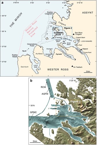
The Wester Ross MPA includes an area of open waters in the Minch as well as the partly enclosed waters hydrographically distinguished from the Minch by a submarine topographic barrier or sill. This prominent bedrock sill runs NE-SW as a shallow bathymetric connection between the headlands of Aultbea and Coigach, and rises above sea level in places in the form of the Summer Isles (). The Summer Isles (technically excluded from the Wester Ross MPA) comprise around 15 islands and a further 20 or so named rocks and skerries within a water area of ca. 80 km2. Inboard (inshore) of the islands the approaches to Loch Broom deepen in three large basins – either side of an elongate submerged bedrock bank, extending NW from Isle Martin, named informally as Martin Bank. The basins, known as Skerries Basin, Annat Basin, and Coigach Basin are typically 100–140 m deep and contain muddy sediment-fills in excess of 50 m thick (Stoker et al., Citation2009). Loch Broom proper starts where the waters narrow to 1.5 km at Rhu Point. From here the sea loch continues for a further 8 km to the SE as a long narrow inlet or fjord; deeper in its outer basin NW of Ullapool (50-100 m below sea level (bsl)), and relatively shallow inshore beyond the Corrie Point narrows (10-50 m bsl). The narrow rocky peninsula of Cailleach Head separates Loch Broom from the adjacent deep-water fjord of Little Loch Broom to the SW. Further west, between the mouth of Little Loch Broom and the Aultbea peninsula is the relatively shallow (<50 m bsl) Gruinard Bay, hosting Gruinard Island (). Currently, seabed dredging and beam trawl fishing is prohibited in all areas within the Wester Ross MPA; with demersal trawl fishing only permitted subject to specific conditions in some areas – typically the deeper basins between the Summer Isles and Gruinard Bay.
The subaqueous moraines: Description
The seabed moraines around the Summer Isles includes more than 50 well-preserved individual ridges extending over an area of approximately 350 km2, all lying within the Wester Ross Marine Protected Area. The moraines, originally identified from multibeam echosounder data and digital elevation models, were first described by Stoker et al. (Citation2006), and placed in a chronological context by Bradwell, Fabel, et al. (Citation2008). Subsequent detailed work on the Quaternary geology and seabed geomorphology was presented by Stoker et al. (Citation2009), Stoker and Bradwell (Citation2011) and by Bradwell and Stoker (Citation2015a, Citation2015b, Citation2016). Moraines and moraine fragments have been mapped stretching from the mouth of Loch Ewe in the south (57.88°N, 5.67°W,) to just north of Rubha Còigeach (58.12°N, 5.50°W). The full extent of the seabed moraines and their association with the surrounding Quaternary geology is shown on a special BGS 1:50,000-scale Quaternary Geology map (BGS, Citation2010) and accompanying ‘sheet explanation’ booklet (Stoker & Bradwell, Citation2011).
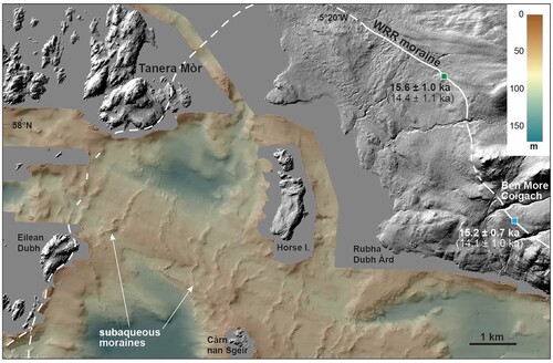
Perhaps the most impressive, most pronounced, moraines are seen on the seabed between Tanera Mòr – the largest of the Summer Isles – and the mouth of Loch Broom. Here around 20 conspicuous, well-preserved, seabed ridges, part of a more extensive suite of moraines, occur on the relatively shallow banks in present-day water depths of 30–80 m ( and ). Occasionally these ridges continue into water depths of 80-90 m, but are notably absent in bathymetric deeps >100 m. In the interest of page space, this short article will focus on the moraines shown within as the type-site for subaqueous moraines around western Scotland more widely.
Figure 2. High-resolution bathymetric-topographic digital elevation model showing the seabed moraines around the Summer Isles and in the approaches to Loch Broom. Elevation model lit from the NW (315) to aid visualisation. Offshore (MBES) data collected by BGS-NERC; cell size 5 m; onshore (airborne radar) data from NEXTMap Britain (Intermap Technologies); cell size 5 m. WRR = Wester Ross Readvance. Solid white line shows mapped ice-sheet limit at WRR; dashed where uncertain. Numbers next to WRR moraine are mean TCN exposure ages from published studies (green box = Bradwell, Fabel, et al., Citation2008; blue box = Ballantyne et al., Citation2009). TCN exposure ages have been re-calibrated using the online CRONUS-Earth calculator (Balco et al., Citation2008). Ages in bold use the Loch Lomond production rate; ages in brackets use the Global default production rate (See Ballantyne & Small, Citation2019 for more details.)
The ridges comprising the focus of this study generally trend in a NE-SW or N-S direction. The seabed moraines are laterally continuous features with few observable breaks. The longest moraines typically extend laterally for 2–3 km, although shorter ridges also occur. Most ridges are easily distinguishable in plan view with single crestlines. This allows a simple numbering system (from #1 to #18) from W to E (). Occasionally ridges appear to be more complex features displaying multiple or bifurcating crestlines. Where moraines are seen to bifurcate, comprise multiple subsidiary fragments or, in rare instances, overprint one another, they have been numbered accordingly (e.g. 8, 8a, 8b); with the shorter or less continuous ridges given the suffix a or b. Most of the complex ridge morphologies occur in the narrows between Horse Island and Carn nan Sgeir. Moraine morphologies vary in plan view, with no two ridges being very similar or ‘mirror images’ of one another. Most moraines are made up of connected arcuate (concave or convex) sections typically 50-200 m in length. Long straight ridge sections (>200 m) are unusual. Occasionally, moraines kink or bend sharply, forming irregular patterns that conform with the local bathymetry (e.g. #6).
Figure 3. Moraine morphology. (upper panel) High-resolution bathymetric digital elevation model (greyscale) illuminated from the NW. Subaqueous moraines are numbered from NW to SE (from oldest to youngest) in direction of ice-front retreat. (long lower panels) Seabed elevation profiles (blue line) perpendicular to moraines; water depths in metres below OD (see upper panel for line of transects). Note profile is split to capture the maximum number of moraines. (small lower panels) Topographic cross-profiles of individual moraine ridges (#3-18). All small graphs at same scale. Dark grey line = typical high-elevation profile; light grey line = typical low-elevation profile; showing normal elevation envelope along moraine length.
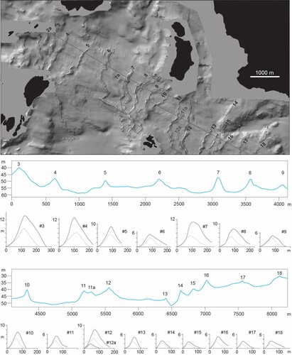
Multibeam echosounder (MBES) bathymetry data show that individual moraines are substantial in size, although elevations vary both along-ridge and between ridges (). Ridge heights range from ca. 2 to 15 m above the surrounding seafloor; with most being in the 5–10 m height range. Individual ridge widths vary from approximately 80 to 250 m. As expected, moraine height and width are positively correlated. More detailed morphological investigations show that ridges generally decrease in size with distance inshore, irrespective of water depth. Bathymetric profiles () show that the outermost ridges (#1-4), in the narrows between Tanera Mor and Eilean Dubh, are significantly larger, typically in excess of 10 m high and over 200 m wide; whilst those closer inshore (#13-18) are smaller, typically only 3–5 m high and ca. 100 m wide. Those moraines in the middle of the sequence (#5-12) are generally intermediate in size, between 5 and 9 m high and 100–200 m wide. There are 2 exceptions to this rule: ridge 7 is larger than the ridges adjacent to it (#6, 8, & 9), and varies considerably in height along its length (from 4 to 11 m). Ridge 7’s somewhat anomalous height may be explained by the apparent superimposition of two moraines at its northern end (#7a & 7b). Ridge 12 is also larger than the adjacent ridges. Interestingly, it too is a composite feature in places; although ridge 12a is only ∼2 m high and discontinuous on MBES data ().
Bathymetric profiles show that ridge asymmetry is common, with 11 of the 18 laterally continuous moraines having steeper W-facing (ice-distal) slopes and gentler E-facing (ice-proximal) slopes (). The remaining 7 are broadly symmetrical in cross-profile. Interestingly, the larger moraines (#1-5 & 7) have a tendency towards cross-profile symmetry, whilst the smaller moraines (#13-18), closer inshore, are generally, but not always, more asymmetric with gentler ice-proximal slopes ().
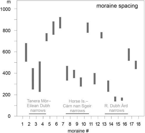
Horizontal spacing between ridges varies but is generally between 200 and 900 m. On Martin Bank where water depths are relatively constant (35-55 m), moraine spacing tends to decrease in the narrows between islands, for example between Tanera Mòr and Eilean Dubh, and between Horse Island and Carn nan Sgeir. shows this relationship well. Away from Martin Bank, in deeper water where moraine ridges become less well defined and/or discontinuous, moraine spacing is harder to determine. Crest-to-crest ridge spacing increases to a maximum (ca. 1200 m between #5 & 6) in the deep basin immediately W of Carn nan Sgeir (). Note that in a few places subtle, or partially buried, smaller ridges are seen between the more substantial moraine ridges (e.g. between #5 & 6). These short, low-amplitude, ridge sections may also relate to the former ice margin, however their exact origin is still uncertain.
Figure 4. Moraine spacing. Graph showing typical crest-to-crest moraine spacings in metres. Distances measured at 2 different points (grey bars) (i) along line of transect (in ), and (ii) ca. 300 m to the south. Moraine number on x-axis. Locations of topographic-bathymetric narrows also shown.
In marine geological mapping and research, multibeam echosounder backscatter data can be used to determine the acoustic reflection properties of the seabed; whilst sub-bottom acoustic (or seismic) profilers are used to characterise the physical properties and architecture of the sub-seabed (Quaternary) sediments and bedrock geology beneath (). The seabed moraines around the Summer Isles have high (relative) backscatter values, akin to those seen where till or bedrock are exposed at seabed, indicating that the moraines are composed of harder ( = more acoustically reflective) material than the surrounding basin-fill sediment. In places, these high backscatter values make the seabed moraines difficult to distinguish on backscatter data, in particular on the hard substrate of Martin Bank ((a, b)). Seabed photographs from Little Loch Broom and at the mouth of Loch Ewe show the moraines to be almost exclusively comprised of Torridonian sandstone boulders and cobbles (). Interestingly, these unusual boulder moraines seen elsewhere in the Wester Ross fjords of NW Scotland, have recently been identified as preferential egg-laying grounds of the critically endangered flapper skate Dipturus intermedius (Dodd et al., Citation2022).
Figure 5. (a) Processed, hillshaded, multibeam echosounder data and (b) uncalibrated backscatter intensity data of the same area, centred on moraine 16. See for location. High backscatter values (darker areas) = hard surfaces; low backscatter values (lighter areas) = softer surfaces. Note how the moraines (arrowed) are less discernible on harder substrata. Horizontal sub-parallel lines are data-collection artefacts. (c) and (d) Extracts of seismic-reflection (boomer) data used to map sub-bottom Quaternary geology and sedimentary architecture. Panel (c) shows the area around moraine 12. Panel (d) shows the area ∼3 km to the SE of moraine 12 where the sub-seabed stratigraphy is more complex. Both panels at same scale; both taken from BGS 2005/04 line 36. For more details on the boomer dataset and its interpretation see Stoker et al. (Citation2009).
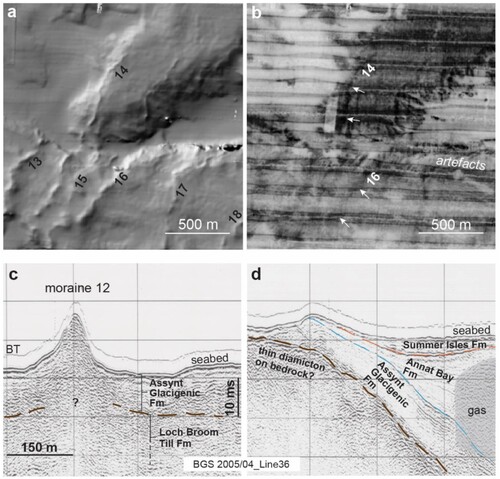
Figure 6. (a) Underwater photograph of boulder-strewn subaqueous moraine in Little Loch Broom at 30 m water depth [57.8942°N, 5.3313°W]. Note squat lobster for scale. (b) Glacially transported boulders on ice-distal flank of same moraine ridge in Little Loch Broom [57.8943°N, 5.3314°W] (see for location). Note the abundance of marine fauna. (c) Surface of subaqueous moraine at the mouth of Loch Ewe (see . for location). The moraine is comprised of densely packed sub-rounded boulders of Torridon Group Sandstone, free from surficial mud and sand. Photograph taken by BGS Rockdrill2 on station 57-06/255 [57.9058°N, 5.6888°W]. Images (a) & (b) are ©Richard Shucksmith, reproduced with permission. Image (c) is ©BGS-UKRI, reproduced with permission.
![Figure 6. (a) Underwater photograph of boulder-strewn subaqueous moraine in Little Loch Broom at 30 m water depth [57.8942°N, 5.3313°W]. Note squat lobster for scale. (b) Glacially transported boulders on ice-distal flank of same moraine ridge in Little Loch Broom [57.8943°N, 5.3314°W] (see Figure 1 for location). Note the abundance of marine fauna. (c) Surface of subaqueous moraine at the mouth of Loch Ewe (see Figure 1. for location). The moraine is comprised of densely packed sub-rounded boulders of Torridon Group Sandstone, free from surficial mud and sand. Photograph taken by BGS Rockdrill2 on station 57-06/255 [57.9058°N, 5.6888°W]. Images (a) & (b) are ©Richard Shucksmith, reproduced with permission. Image (c) is ©BGS-UKRI, reproduced with permission.](/cms/asset/16938012-e2f2-4fc2-b55e-6507cfd93f77/rsgj_a_2226452_f0006_oc.jpg)
Surface-towed boomer sub-bottom profiles across the moraines show the stratigraphy and composition of the landforms and the surrounding seabed ((c, d)). Seismic (boomer) reflection data was collected at relatively high frequency (200–800 Hz) allowing for optimal vertical resolution (<0.5 m), combined with good penetration depth (typically >30 m). Stoker et al. (Citation2009) undertook a detailed seismo-stratigraphic study of the whole Summer Isles region utilising 57 boomer profiles (totalling 235 km in length). This work, covering much of the area now within the Wester Ross MPA, underpins the Late Quaternary offshore (and onshore) stratigraphic framework of NW Scotland (Stoker & Bradwell, Citation2011; Stoker et al., Citation2011). Readers are referred to these works for more information on the lithostratigraphic scheme and geological unit definitions. In summary, the Quaternary geology of the fjordic succession is divided into 5 main lithostratigraphic formations, from oldest to youngest: (1) Loch Broom Till Formation (Fm); (2) Assynt Glacigenic Fm; (3) Annat Bay Fm; (4) Ullapool Gravel Fm; and (5) Summer Isles Fm ((c, d)). The moraines and the glaciomarine deposits around the Summer Isles and in the approaches to Loch Broom fall within the Assynt Glacigenic Fm (Stoker et al., Citation2009).
Vibrocores taken in 2007 aboard RRS James Cook have ground-truthed the sediments within and between the seabed moraines around the Summer Isles and in the fjords of northern Wester Ross. Core 57-06/262 () recovered 0.6 m of stiff matrix-supported clast-rich diamicton with some faceted and striated clasts (up to cobble grade) of Torridon sandstone and Moine lithologies. This coarse poorly sorted unit is overlain by a 3.8-m thick laminated mud (silt and clay) showing rhythmic colour banding on a millimetre to decimetre scale. Rare isolated dropstones are also observed in this clay-rich unit. Micro and macro subfossil shells recovered from this unit, and its equivalent elsewhere, indicate cold but not fully arctic conditions consistent with a glaciomarine environment (Stoker et al., Citation2009). Both these sediment units – the stiff glacial diamicton and laminated glaciomarine mud – sit within the Assynt Glacigenic Fm, which occurs extensively at seabed around the Summer Isles and in the fjord approaches (Stoker et al., Citation2009; BGS, Citation2010).
Interpretation: formation, retreat style and pace
The whole well-preserved seabed landsystem represents an excellent ‘type-site’ example of subaqueous moraines formed at the grounded tidewater margin of one or more ice-sheet (fjordic) outlet glaciers flowing from mainland Scotland (northern Wester Ross) and terminating amongst the nearshore islands (Bradwell, Fabel, et al., Citation2008; Bradwell & Stoker, Citation2016). The term De Geer moraines is often used to describe well-defined, sharp-crested, subaqueous moraines forming a coherent sequence such as this. Some researchers assign annual formation to De Geer moraines, although this is not explicitly part of the original definition (Benn & Evans, Citation2010; De Geer, Citation1889). The Summer Isles moraines would have formed sequentially as sediment was dumped, squeezed or pushed up at the grounded marine-terminating glacier margin. Interestingly the absence, or discontinuous nature, of moraines in places demonstrates that grounding did not extend across the deeper basins, suggesting that the ice margin was buoyant and partially floating in deeper water (e.g. either side of Martin Bank) (Bradwell & Stoker, Citation2015b). This observation and the fact that the moraines exist in present-day seawater depths of up to 95 m is taken as evidence that these moraines formed in a subaqueous (marine) environment and have never been above sea level since. By way of affirmation, there is no evidence for relative sea levels in this part of NW Scotland (58°N, 3°W) to have been 50–100 m lower than present during deglaciation, with the most-recent GIA modelling showing notably higher relative sea levels here during the final stages of Minch ice stream retreat (18–15 ka) (Shennan et al., Citation2018; Simms et al., Citation2022; Bradley et al., Citation2023).
Some workers have used the size and spacing of subaqueous moraines to make inferences about the former dynamics of tidewater glaciers (e.g. Boulton, Citation1986; Dowdeswell et al., Citation2008; Ottesen et al., Citation2008). In essence, moraine size is a function of time and/or sediment supply to the glacier margin or grounding line – with larger moraines indicating a longer residence time, greater sediment flux at the ice margin, or both (Benn & Evans, Citation2010). Exceptions to this general rule occur during short-lived abrupt readvance events, or surges, when large amounts of sediment can be thrust or displaced horizontally to form oversized moraines (Evans & Rea, Citation2003). The subaqueous moraine sequence described here, in the Wester Ross MPA, shows a decrease from larger moraines further offshore (#1-5) to considerably smaller features closer to shore (#9-18), with no anomalously large moraines nor clear geomorphological evidence of surging. [Note we have excluded moraine #1 in the following discussion as it is laterally discontinuous and is only partially imaged in MBES data with <500 m of its length captured.] The simplest formation model involves a longer ice-margin residence time at moraines #2-5 than those closer inshore, as might be expected in the topographic narrows between Tanera Mòr and Eilean Dubh. Moraines #2-5 are also more symmetrical in cross profile suggesting a predominance of sediment dumping and/or squeezing perhaps at the expense of ice-front glaciotectonics (i.e. pushing or stacking). We equate the Tanera Mòr–Eilean Dubh stage (moraines #2-4) with the Wester Ross Readvance moraine on the adjacent Scottish mainland, based on optimal projection of onshore latero-frontal moraines and ice-marginal geometry ().
Adopting the same reasoning, the smaller (lower-elevation), asymmetric, recessional moraines inboard of moraine #5 probably indicate shorter ice-margin residence times with pushing or ‘bulldozing’ the dominant mode of formation. Such a situation would occur if the tidewater ice-margin retreated from the local WRR maximum limit (moraines #2-4) back towards Loch Kanaird and Loch Broom via a series of stillstands or minor readvances. This type of oscillatory ice-frontal retreat has been reported from the fjords of Svalbard (Ottesen & Dowdeswell, Citation2006; Burton et al., Citation2016; Flink et al., Citation2016), Arctic Canada (Boulton, Citation1986; Todd et al., Citation2023), and the Antarctica Peninsula (Batchelor et al., Citation2019). In these studies, small (<3 m high; < 30 m wide), closely spaced (<100 m), recessional moraines are typically associated with annual formation, possibly in response to reduced iceberg calving and widespread sea-ice formation during winter. We do not think annual formation for the Summer Isles moraines is likely, based on their considerably larger size (3-15 m high; 100-200 m wide) and much greater average spacing (>400 m).
Other evidence that goes against annual formation for the Summer Isles moraines is listed below. (1) Moraine planform differs markedly from one moraine to the next (e.g. #5, #6, #7), implying evolution of the ice-front or grounding line between successive moraine-forming events. This is not normally seen in annual moraine sequences, where monotony of form prevails. (2) Several moraines have multiple crests or are composite features (e.g. #8, #11, #12) implying re-occupation of the same (or similar) grounding-line location on more than one occasion. Again, this is not normally seen in annual moraine sequences, where inter-ridge spacings tend to be more even and regular. (3) Annual moraines, of the size typically seen elsewhere, have low preservation potential and as such are rarely seen in the subaqueous or terrestrial Pleistocene record (e.g. Ottesen et al., Citation2008; Burton et al., Citation2016). We would suggest that preservation of subtle annual moraines in a hydrodynamically active seafloor setting, such as the waters around NW Scotland, is unlikely over the intervening ∼15,000 years. Subsequent burial by fine-grained glaciomarine and marine sediment makes their geomorphic expression at seabed even less likely, though not impossible.
On the balance of evidence, we therefore equate the Summer Isles moraines with multi-annual, possibly decadal, grounding-line stillstands of the type seen during the ‘Little Ice Age’ in contemporary subaqueous glacial settings (e.g. NW Spitsbergen). This would place formation of the whole 9-km long moraine sequence in a time window >200 years long, and possibly much longer (>500 yrs). By contrast, annual formation would place the whole moraine sequence in within a ∼20-year time window.
Age of the moraines
Irrespective of the precise rate of retreat, the age of the moraines can be deduced from several lines of evidence. Recently published work, part of the Britice-Chrono project, has shown that the wider suite of seabed moraines in the eastern Minch and Summer Isles region, west of Tanera Mòr, formed soon after the demise of the Minch Ice Stream ca. 18 ka (Bradwell et al., Citation2019, Citation2021) and prior to the Wester Ross Readvance (WRR) – a regional ice-sheet oscillation that affected NW mainland Scotland ca. 15.5 ka BP (Ballantyne & Small, Citation2019; Bradwell et al., Citation2021). Geomorphological correlation shows that the seabed moraines between Tanera Mòr and Eilean Dubh, described in this article, probably formed during the WRR. Cosmogenic-nuclide exposure ages of boulders on the WRR moraine near Achiltibuie in Coigach – terrestrial equivalents of subaqueous moraines #2-4 – yielded recalibrated ages of between 15.2 ± 0.7 and 15.6 ± 1.0 ka (Ballantyne et al. Citation2009; Ballantyne & Small, Citation2019; Bradwell, Fabel, et al., Citation2008) (). We therefore equate the formation of subaqueous moraines #2-4 to ca. 15.5 ka, although we acknowledge the uncertainty envelope accompanying these dates (±1.0 ka). The suite of recessional moraines (#5-18) on Martin Bank inboard of Tanera Mòr are demonstrably younger than this, but must be older than the glaciomarine/deltaic sediments exposed on the shore of Loch Kanaird and recently OSL-dated to 14.3 ± 0.9 ka (full age range: 13.7 ± 1.3 ka to 14.8 ± 1.9 ka) (Bradwell et al., Citation2021).
Other chronological evidence comes from AMS 14C dating of marine shells from glaciomarine sediments deposited between the subaqueous moraines, reported by Stoker et al. (Citation2009). An Arctica islandica shell in BGS vibrocore 57-06/279 returned a radiocarbon age of 12,710 ± 42 a, calibrated to 14.11 ± 0.10 ka BP (using Fairbanks et al., Citation2005) or 14.20 ± 0.10 ka using the Marine20 calibration (and DR = 0) (Heaton et al., Citation2020). A valve of Lucinoma borealis from within the same stratigraphic unit in SAMS gravity core GC101 returned a similar calibrated age: 13.97 ± 0.07 (updated to 14.03 ± 0.07, using Marine20). These ages are clearly an upper estimate for the time of deposition of this dropstone-poor, relatively distal, glaciomarine mud, as the base of the unit was not recovered in these cores. Above these dated horizons ice-rafted debris becomes increasingly rare. That notwithstanding, the 14C age constraints imply that glaciers still terminated in cold boreal waters in the Wester Ross fjords at, and prior to, 14.2 ka BP. The current, albeit limited, dating evidence from this catchment is consistent with glaciers in Loch Kanaird and Loch Broom receding inshore of the marine limit by ca. 14.3-14.0 ka BP. Further work is needed to determine a higher-resolution chronology at the marine-terrestrial transition.
In summary, we propose the following sequence of events based on the submarine (and terrestrial) geomorphology and currently available dating evidence:
Retreat of the ice-sheet sector to the waters around Wester Ross following Minch Ice Stream demise (or collapse?). Tidewater ice front grounded at the Loch Ewe-Greenstone Point Moraine Complex and Rubha Coigach moraines (), W of the Summer Isles Sill, probably ca. 17.5–16.5 ka BP (Bradwell et al., Citation2021).
Oscillatory ice-front retreat totalling over 15 km to inshore of the Summer Isles Sill (precise distance unknown), probably ca. 16.5–16.0 ka BP.
Re-advance back to the Summer Isles Sill (grounded as far as moraines #2-4, between Tanera Mòr and Eilean Dubh), probably culminating ca. 15.5 ka BP, but possibly culminating as late as 14.5 ka BP. We equate this to the Wester Ross Readvance seen widely across NW mainland Scotland.
Following the WRR, this large tidewater glacier underwent punctuated oscillatory retreat between the Summer Isles Sill and Loch Broom (depositing moraines #5-18), but remained essentially quasi-stable in this relatively confined, predominantly shallow, fjord-mouth setting for a considerable period of time, between ∼15.5 ka and ∼14.5 ka. This inference assumes that sediment supply to the glacier front and glaciomarine sediment-accumulation rates remained relatively constant throughout this period, and that the subaqueous moraines represent oscillations on a multi-year to decadal, rather than annual, timescale.
Continued oscillatory retreat of outlet glaciers to fjord heads, with glacier margins probably back beyond the marine limit by ∼14.3 ka and almost certainly by ∼14.0 ka BP (Bradwell et al., Citation2021).
Wider implications for geomorphology, marine ecology and conservation
The area enclosed within the Wester Ross Marine Protected Area was deliberately chosen (as set out by the Scottish Ministerial Order of July 2014) to include seabed glacial landforms and other geomorphological features of importance, in addition to a wide range of marine life and seabed habitats. The extensive suite of well-preserved subaqueous moraines offers valuable and unique insights into the rate and style of ice-sheet decay and, we would argue, is deemed worthy of protection on geological / geomorphological grounds alone. However, these seabed features also act as critical benthic habitats for a range of marine species – providing an inextricable link between geomorphological diversity and marine ecology. Good examples include the burrowed mud habitats of the Skerries, Coigach and North Annat Basins hosting Norway lobster and rare seapens; as well as the hard rocky substrates of the nearshore moraines hosting flame shell beds, northern feather stars and potentially acting as egg-laying habitats for skate and other demersal fish (see Dodd et al., Citation2022). This general link between marine geology / geomorphology and benthic habitat has been known for some time (e.g. Wright & Heyman, Citation2008). So much so, that seabed geomorphological mapping is now well established as a proxy for marine habitat mapping (e.g. Harris & Baker, Citation2012). However, the links between specific, relatively unusual, submarine landforms, such as relict boulder moraines, in mid-latitude fjords, and their potential to host rare or niche ecological communities is still a developing field. Research in this discipline, at the interface between marine ecology and marine geology / geomorphology, is perhaps even more important as Scotland seeks to increase and strengthen its MPA network (Scottish Government, Citation2022).
Conclusion
The remarkable well-preserved seabed moraines around the Summer Isles and in the approaches to Loch Broom are an important key site for the landform record of Scotland as they provide a unique subaqueous moraine record of former tidewater ice-sheet retreat across an area of approximately 200 km2. The moraines, all within the Wester Ross MPA, chart oscillatory ice-margin retreat of one of Scotland’s largest tidewater fjordic glaciers at the end of the last (Weichselian / Devensian) glaciation. At that time, a continuous ice-front would have stretched over 15 km from the mouth of Little Loch Broom to the Coigach peninsula. This ‘Scottish Landform Example’ article focused on 18 of these moraines, part of a wider sequence of subaqueous moraines extending from the eastern Minch to the head of Loch Broom, all well captured in multibeam-echosounder bathymetry data. Some of these moraines have been linked with a regional ice-sheet readvance, identified onshore in NW Scotland, known as the Wester Ross Readvance. We strengthen this connection by linking previously dated terrestrial moraines in Coigach to the sub-sea moraines between the islands of Tanera Mòr and Eilean Dubh. Through this clear association, we firmly ascribe part of the underwater moraine sequence to the time of the Wester Ross Readvance (ca. 15.5 ka BP). Those moraines inshore (to the SE) of this limit formed during smaller ice-front or grounding-line readvances (or stillstands) as the tidewater glacier retreated. We use geomorphological evidence to conclude that each moraine in the sequence took multiple years, possibly decades, to form – rather than forming annually. Continued protection of these seabed landforms is important, both on geological and ecological grounds. The boulder-strewn moraines and adjacent mud-rich basins are known to host an unusual diversity of marine flora and fauna, with the moraines potentially also acting as rare spawning grounds or nurseries for endangered species.
Access information
The moraines are on the seabed and are therefore inaccessible. The whole water area is within the Wester Ross Marine Protected Area. A good view of the sea area, from land, can be gained from the small hill ca. 2 km NW of Ullapool as the A835 heads north. There is a roadside layby at 57.9137°N, 5.1848°W.
Acknowledgements
TB is an Honorary Research Associate of the British Geological Survey. MS gratefully acknowledges the award of Visiting Research Fellow in the Discipline of Earth Sciences, School of Physics, Chemistry & Earth Sciences, University of Adelaide. The authors thank reviewers and editor for their comments on a previous draft of this article.
Disclosure statement
No potential conflict of interest was reported by the author(s).
Correction Statement
This article was originally published with errors, which have now been corrected in the online version. Please see Correction (http://dx.doi.org/10.1080/14702541.2023.2238568)
Additional information
Funding
Notes
1 Not including landforms classified as Rogen moraine, ribbed moraine and medial moraines, which are not ice-marginal landforms.
References
- Balco, G., Stone, J. O., Lifton, N. A., & Dunai, T. J. (2008). A complete and easily accessible means of calculating surface exposure ages or erosion rates from 10Be and 26Al measurements. Quaternary Geochronology, 3(3), 174–195. https://doi.org/10.1016/j.quageo.2007.12.001
- Ballantyne, C. K., Schnabel, C., & Xu, X. (2009). Readvance of the last British-Irish Ice Sheet during Greenland Interstade 1 (GI-1): The Wester Ross Readvance, NW Scotland. Quaternary Science Reviews, 28(9–10), 783–789. https://doi.org/10.1016/j.quascirev.2009.01.011
- Ballantyne, C. K., & Small, D. (2019). The last Scottish Ice Sheet. Earth and Environmental Science Transactions of the Royal Society of Edinburgh, 110(1–2), 93–131. https://doi.org/10.1017/S1755691018000038
- Batchelor, C., Dowdeswell, J., Hogan, K., Larter, R., Parsons, E., & West, O. (2019). Processes and patterns of glacier-influenced sedimentation and recent tidewater glacier dynamics in Darbel Bay, western Antarctic Peninsula. Antarctic Science, 31(4), 218–227. https://doi.org/10.1017/S0954102019000191
- Benn, D. I., & Evans, D. J. A. (2010). Glaciers and Glaciation (p. 811). Routledge.
- Boulton, G. S. (1986). Push-moraines and glacier-contact fans in marine and terrestrial environments. Sedimentology, 33(5), 677–698. https://doi.org/10.1111/j.1365-3091.1986.tb01969.x
- Bradley, S. L., Ely, J. C., Clark, C. D., Edwards, R. J., & Shennan, I. (2023). Reconstruction of the palaeo-sea level of Britain and Ireland arising from empirical constraints of ice extent: Implications for regional sea level forecasts and North American ice sheet volume. Journal of Quaternary Science. https://doi.org/10.1002/jqs.3523
- Bradwell, T., Fabel, D., Clark, C. D., Chiverrell, R. C., Small, D., Smedley, R. K., Saher, M. H., Moreton, S. G., Dove, D., Callard, S. L., Duller, G. A. T., Medialdea, A., Bateman, M. D., Burke, M. J., McDonald, N., Gilgannon, S., Morgan, S., Roberts, D. H., & Ó Cofaigh, C. (2021). Pattern, style and timing of British–Irish Ice Sheet advance and retreat over the last 45 000 years: Evidence from NW Scotland and the adjacent continental shelf. Journal of Quaternary Science, 36(5), 871–933. https://doi.org/10.1002/jqs.3296
- Bradwell, T., Fabel, D., Stoker, M., Mathers, H., McHarge, L., & Howe, J. (2008). Ice caps existed throughout the Lateglacial Interstadial in northern Scotland. Journal of Quaternary Science, 23(5), 401–407. https://doi.org/10.1002/jqs.1181
- Bradwell, T., Small, D., Fabel, D., Smedley, R. K., Clark, C. D., Saher, M., Callard, S. L., Chiverrell, R. C., Dove, D., Moreton, S. G., Roberts, D. H., Duller, G. A. T., & Ó Cofaigh, C. (2019). Ice-stream demise dynamically conditioned by trough shape and bed strength. Science Advances, 5(4), eaau1380. https://doi.org/10.1126/sciadv.aau1380
- Bradwell, T., & Stoker, M. S. (2015a). Asymmetric ice-sheet retreat pattern around northern Scotland revealed by marine geophysical surveys. Earth and Environmental Science Transactions of the Royal Society of Edinburgh, 105(4), 297–322. https://doi.org/10.1017/S1755691015000109
- Bradwell, T., & Stoker, M. S. (2015b). Submarine sediment and landform record of a palaeo-ice stream within the British−Irish Ice Sheet. Boreas, 44(2), 255–276. https://doi.org/10.1111/bor.12111
- Bradwell, T., & Stoker, M. S. (2016). Recessional moraines in nearshore waters, northern Scotland. Geological Society, London, Memoirs, 46(1), 63–64. https://doi.org/10.1144/M46.13
- Bradwell, T., Stoker, M. S., Golledge, N. R., Wilson, C., Merritt, J., Long, D., Everest, J., Hestvik, O., Stevenson, A., Hubbard, A., Finlayson, A., & Mathers H. (2008). The northern sector of the last British Ice Sheet: Maximum extent and demise. Earth-Science Reviews, 88(3–4), 207–226. https://doi.org/10.1016/j.earscirev.2008.01.008
- British Geological Survey. (2010). Quaternary geology of the Summer Isles. 1:50,000 Maremap series (special sheet). British Geological Survey.
- Burton, D. J., Dowdeswell, J. A., Hogan, K. A., & Noormets, R. (2016). Little Ice Age terminal and retreat moraines in Kollerfjorden, NW Spitsbergen. Geological Society, London, Memoirs, 46(1), 71–72. https://doi.org/10.1144/M46.35
- De Geer, G. F., (1889). Andmoraner I trakten mellan Spanga och Sundbyberg. Geologiska Foreningens i Stockholm Forhandlinga, 11(7), 395–400. https://doi.org/10.1080/11035898909445835
- Dodd, J., Baxter, J. M., Donnan, D. W., James, B. D., Lavender, E., McSorley, C. A., Mogg, A. O. M., & Thorburn, J. A. (2022). First report of an egg nursery for the critically endangered flapper skate Dipturus intermedius (Rajiformes: Rajidae). Aquatic Conservation: Marine and Freshwater Ecosystems, 32(10), 1647–1659. https://doi.org/10.1002/aqc.3857
- Dove, D., Arosio, R., Finlayson, A. G., Bradwell, T., & Howe, J. (2015). Submarine glacial landforms record Late Pleistocene ice-sheet dynamics, Inner Hebrides, Scotland. Quaternary Science Reviews, 123, 76–90. https://doi.org/10.1016/j.quascirev.2015.06.012
- Dowdeswell, J. A., Canals, M., Jakobsson, M., Todd, B. J., Dowdeswell, E. K., & Hogan, K. A. (2016). The variety and distribution of submarine glacial landforms and implications for ice-sheet reconstruction. Geological Society, London, Memoirs, 46(1), 519–552. https://doi.org/10.1144/M46.183
- Dowdeswell, J. A., Ottesen, D., Evans, J. O., Cofaigh, C., & Anderson, J. B. (2008). Submarine glacial landforms and rates of ice-stream collapse. Geology, 36(10), 819–822. https://doi.org/10.1130/G24808A.1
- Evans, D. J. A., & Rea, B. R. (2003). Surging glacier landsystems. In D. J. A. Evans (Ed.), Glacial landsystems (pp. 259–288). Arnold.
- Fairbanks, R. G., Mortlock, R., Chiu, T.-C., Cao, L., Kaplan, A., Guilderson, T. P., Fairbanks, T. W., Bloom, A. L., Grootes, P. M., & Nadeau, M. (2005). Radiocarbon calibration curve spanning 0 to 50,000 years BP based on paired 230Th/234U/238U and 14C dates on pristine corals. Quaternary Science Reviews, 24(16–17), 1781–1796. https://doi.org/10.1016/j.quascirev.2005.04.007
- Flink, A. E., Noormets, R., & Kirchner, N. (2016). Annual moraine ridges in Tempelfjorden, Spitsbergen. Geological Society, London, Memoirs, 46(1), 75–76. https://doi.org/10.1144/M46.64
- Graham, A. G. C., Lonergan, L., & Stoker, M. S. (2009). Seafloor glacial features reveal the extent and decay of the last British Ice Sheet, east of Scotland. Journal of Quaternary Science, 24(2), 117–138. https://doi.org/10.1002/jqs.1218
- Harris, P. T., & Baker, E. K. (2012). Why Map benthic habitats? In P. T. Harris & E. K. Baker (Eds.), Seafloor Geomorphology as Benthic Habitat (pp. 3–22). Elsevier.
- Heaton, T., Köhler, P., Butzin, M., Bard, E., Reimer, R. W., Austin, W. E., Bronk Ramsey, C., Grootes, P. M., Hughen, K. A., Kromer, B., Reimer, P., Adkins, J., Burke, A., Cook, M. S., Olsen, J., & Skinner, L. C. (2020). Marine20—The marine radiocarbon age calibration curve (0–55,000 cal BP). Radiocarbon, 62(4), 779–820. https://doi.org/10.1017/RDC.2020.68
- McIntyre, K., Howe, J. A., & Bradwell, T. (2011). Lateglacial ice extent and deglaciation of Loch Hourn, western Scotland. Scottish Journal of Geology, 47(2), 169–178. https://doi.org/10.1144/0036-9276/01-433
- Ottesen, D., & Dowdeswell, J. A. (2006). Assemblages of submarine landforms produced by tidewater glaciers in Svalbard. Journal of Geophysical Research, 111(F1), 2005JF000330. https://doi.org/10.1029/2005JF000330
- Ottesen, D., Dowdeswell, J. A., Benn, D. I., Kristensen, L., Christiansen, H. H., Christensen, O., Hansen, L., Lebesbye, E., Forwick, M., & Vorren, T. O. (2008). Submarine landforms characteristic of glacier surges in two Spitsbergen fjords. Quaternary Science Reviews, 27(15–16), 1583–1599. https://doi.org/10.1016/j.quascirev.2008.05.007
- Scottish Government. (2022). Scottish highly protected marine areas: Consultation paper. https://consult.gov.scot/marine-scotland/scottish-highly-protected-marine-areas/.
- Shennan, I., Bradley, S. L., & Edwards, R. (2018). Relative sea-level changes and crustal movements in Britain and Ireland since the Last Glacial Maximum. Quaternary Science Reviews, 188, 143–159. https://doi.org/10.1016/j.quascirev.2018.03.031
- Simms, A., Best, L., Shennan, I., Bradley, S. L., Small, D., Bustamente, E., Lightowler, A., Osleger, D., & Sefton, J. (2022). Investigating the roles of relative sea-level change and glacio-isostatic adjustment on the retreat of a marine-based ice stream in NW Scotland. Quaternary Science Reviews, 277, 107366. https://doi.org/10.1016/j.quascirev.2021.107366
- Stewart, H., Bradwell, T., Carter, G., Dove, D., & Gafeira, J. (2021). Geomorphology of the continental shelf. In C. K. Ballantyne & J. E. Gordon (Eds.), Landscapes and landforms of Scotland (pp. 233–250). Springer Nature.
- Stoker, M. S., Balson, P. S., Long, D., & Tappin, D. R. (2011). An overview of the lithostratigraphical framework for the Quaternary deposits on the United Kingdom continental shelf. British Geological Survey Research Report, RR/11/03.
- Stoker, M. S., & Bradwell, T. (2011). Quaternary geology of the summer isles region – A brief explanation of the summer isles special sheet (Scotland). British Geological Survey.
- Stoker, M. S., Bradwell, T., Howe, J. A., Wilkinson, I. M., & McIntyre, K. (2009). Lateglacial ice-cap dynamics in NW Scotland: Evidence from the fjords of the Summer Isles region. Quaternary Science Reviews, 28(27–28), 3161–3184. https://doi.org/10.1016/j.quascirev.2009.09.012
- Stoker, M. S., Bradwell, T., Wilson, C., Harper, C., Smith, D., & Brett, C. (2006). Pristine fjord landsystem revealed on the sea bed in the Summer Isles region, NW Scotland. Scottish Journal of Geology, 42(2), 89–99. https://doi.org/10.1144/sjg42020089
- Todd, B. J., Dowdeswell, J. A., Shaw, J., Campbell, C., & Mate, D. J. (2023). Deglacial dynamics of the Foxe–Baffin Ice Sheet, Frobisher Bay, Nunavut, Canada revealed by submarine landform mapping. Journal of Quaternary Science, 38(3), 365–385. https://doi.org/10.1002/jqs.3486
- Wright, D. J., & Heyman, W. D. (2008). Introduction to the special issue: Marine and coastal GIS for geomorphology. Habitat Mapping, and Marine Reserves, Marine Geodesy, 31, 223–230. https://doi.org/10.1080/01490410802466306