
Abstract
This paper adopts a geosemiotics perspective to the study of top-down views produced by drone hobbyists to explore how they challenge or disrupt traditional meanings associated with verticality. Using a dataset of 748 drone visuals collected from two months of participant observation on social media platforms, we identify four unique functions of top-down views: as abstract art, as transformations of the mundane, as playful mapping and as dronies. Through prototypical examples, we demonstrate how civilian drones have created new forms of visualising and embodying our world, acting as intermediaries between humans and nature and, thus, challenging persisting negative associations of the link between verticality and power. Overall, our findings encourage a reappraisal of the drone as an object and see it instead as a complex material assemblage of the sky, which has the ability to extend our perception, modify our geographical imaginations and multiply our possible interpretations of the top-down view.
Introduction
Grounded in Judeo-Christian discourse and the concept of the God’s eye view, vertical angles have a long historical association with panoptic surveillance and unequal power dynamics (Amad Citation2012, 67). These perceptions have persisted in contemporary society as a result of widespread media reports of military drone strikes and surveillance activities that tend to associate the view from above with air supremacy, territorial defence and human annihilation, thereby generating an unbalanced power dynamic between the producer and viewers (Kaplan Citation2018). However, reading the vertical as a site of pure domination underestimates the complexities and tensions that surround top-down representations and overlooks their ability to construct new knowledge and insights about the world around us for ‘good’, whether for the purposes of landscape architecture, urban design or ecology (Serafinelli and O’Hagan Citation2022).
This is particularly the case for drones – uncrafted flying vehicles – which have moved beyond the military sphere in recent decades and are now increasingly used by entrepreneurs, hobbyists, citizen scientists and artists alike. This democratisation of the drone has advanced studies in visuality and visual culture, with scholars shifting their focus from the omniscient and intrusive nature of the top-down view to ways in which it can be used in ‘counter-hegemonic and rhetorically inventive ways’ (Mangold and Goehring Citation2019). Recent drone studies have explored, for example, its new modes of relational experience (Garrett and McCosker Citation2017), its ‘new camera consciousness’ (McCosker and Wilken Citation2020), its diversification of the panoptic gaze (Zuev and Bratchford Citation2020) and the impact of its visual sensory capacities on the human sensorium (Agostinho, Maurer, and Veel Citation2020).
These studies offer an important step forward in our general understanding of verticality and how it can transform the visual field, reshape our sensory formations and alter human perceptions, both culturally and emotionally (Christiansen Citation2020). However, to date, little attention has been given to vertical images produced by drone hobbyists and their role in sense-making processes, geographical imaginations and everyday life experiences. When created by civilians, vertical images have the potential to create a synesthetic space that disrupts our understanding of familiar environments through abstractions and striking visual patterns that expand our visual sense and transcend typical visual hierarchies and orientations (Hollman Citation2020; Serafinelli and O’Hagan Citation2022). A detailed study of such visuals, thus, offers an opportunity to challenge the general association between verticality and exercises of power/systems of control, thereby establishing an alliance between power and visibility that constantly provides opportunities for ‘reaction, redistribution and resistance’ (Pauschinger and Klauser Citation2020, 463).
With the purpose of filling this gap, this paper adopts a geosemiotics perspective to the study of top-down views produced by drone hobbyists to explore how they diversify current understandings of verticality (Scollon and Scollon Citation2003). In doing so, it aims to nuance persisting negative associations of the ‘view from above’ with warfare and surveillance (Kaplan Citation2018) and foster a broader appreciation of the ways in which drones have created new forms of visualising and embodying our world, acting as intermediaries between humans and nature (Benjamin Citation2020). The data drawn upon in this paper consists of 748 drone visuals collected during two months of participant observation on social media of the photo-sharing practices of 16 drone hobbyists. It is part of a broader study into the impact of civilian drones on contemporary visual cultures.
The paper begins by outlining historical perspectives on verticality and its sociocultural meanings, as well as current debates on verticality in drone studies in terms of surveillance, sousveillance and creative resistance. It then moves on to explain the geosemiotics approach adopted in this study and the data that will be explored. Next, a geosemiotic analysis, embedded in theory from drone studies, is carried out on six prototypical examples from the dataset that emphasise the creative potential of drones and how they can foster new appreciations of the top-down angle. Finally, the paper concludes with a critical discussion of how civilian drones are changing our knowledge of the world around us, particularly in reference to verticality.
Surveillance, Sousveillance and Creative Resistance: Verticality Through the Lens
Whether kites, balloons, rockets or helicopters, throughout history, technological advances in aeronautics and optics have created new and potentially disruptive ways of seeing the world (Mangold and Goehring Citation2019). When the Wright brothers made their first flight in 1903, the plane was regarded by many as a symbol of progress and subhuman achievement, thereby generating a utopian vision of the view from above. However, the invention of plane-mounted photography began to change this, producing heterotopian narratives that offered disquieting feelings of how we think about the space around us (Amad Citation2012). As planes became used in World Wars One and Two for aerial bombing, dystopian views started to dominate our understanding of aerial vision (Pong Citation2019). Recent decades have seen a range of landscape architectural and art projects that contradict the notion that the view from above is always negatively charged (e.g. James Corners’ Taking Measures Across the American Landscape (Citation1996) and Yann Arthus-Bertrand’s Earth from the Air (Citation2001)). However, in the public consciousness, unfavourable perceptions persist and have, in fact, been consolidated over time by events such as 9/11 and the Pakistan drone strikes (Greene Citation2015).
Drones extend this long lineage of aerial perspectives dating back to the 1840s when balloons were first used in the Napoleonic Wars (Richardson Citation2020), but also further beyond to the concept of the God’s-eye view, present in biblical discourses and referring to God’s all-seeing gaze (Amad Citation2012; Brighenti and Pavoni Citation2021). Bridle (cited in Greene Citation2015, 239) sees drone vision as a product of ‘the technology that was supposed to bring us closer together [now] used to obscure and obfuscate,’ while Maurer (Citation2016, 142) views it as a form of man hunting, a dichotomy between ‘predator and prey, enemy and friend, the familiar and the unfamiliar.’ Drone vision creates landscapes and perspectives that are out of mundane human vision. Here, technology is not simply a medium, but a full partner in the world-making process (Haraway Citation2007, 245). These actions are described by Grayson and Mawdsley (Citation2018) as ‘scopic regimes’, i.e. ‘practices of seeing, representing and subject positioning linked to systems of knowledge and power that shape what can be understood as true.’
Today, drones have moved beyond their military context and are used for a wide range of commercial and domestic purposes. McCosker (Citation2015) and Hildebrand (Citation2020) argue that this has reshaped our vertical publics, heightening public concerns about optical surveillance and privacy invasion and perpetuating the concept of the ‘bad’ drone. This view is shared by both Bracken-Roche (Citation2016) and Jablonowski (Citation2020) who see drone vision as a hierarchical and hierarchised way of looking that ‘divides the world into those who are the rightful subjects and objects of the gaze.’ However, Sandvik and Jumbert (Citation2016, 14) believe that drones are not predestined to be ‘good’ or ‘bad’; rather, they are tools that their owners choose to use in ‘good’ or ‘bad’ ways. This notion is supported by Amad (Citation2012) who advocates for a ‘Janus-faced’ view in-between, contending that aerial views force a critical penetration of nature and mortality and, therefore, can showcase the collective human responsibility for the earth’s future rather than simply be considered weapons of surveillance and information control. This need to refine how we understand the drone is apparent when considering its diversity of application across a range of fields, from wildlife conservation, search and rescue operations and agriculture to journalism, tourism and humanitarian aid (e.g. Sandvik and Lohne Citation2014; Adams Citation2019; Stankov et al. Citation2019; Frankelius, Norrman, and Johansen Citation2019; Millner Citation2020; Del-Real and Díaz-Fernández Citation2021).
In many of these fields, drones are used as a form of ‘sousveillance’ rather than surveillance, employed in creative ways by those on the ground to redirect potential mechanisms of surveillance back onto the Establishment (Waghorn Citation2016). In other words, drones are encouraging a ‘new visibility’ that has the potential to answer the age-old question ‘who watches the watchmen?’ (Thompson Citation2005). Both Waghorn (Citation2016) and Zuev and Bratchford (Citation2020) have researched the use of drones by activists and protestors to hold authority figures accountable by generating evidence of events and recording incidences of misconduct. Similarly, Millner (Citation2020) has explored the use of drones by indigenous groups in Guatemala as mediators of a ‘cartographic testimony’ (or what Weizman (Citation2017) calls ‘forensic architecture’) that challenges dispossession and unsettles new and dominant vertical orders. In both cases, by co-opting drone technology, visibility is reclaimed as a form of resistance to top-down governmental surveillance and the idea of asymmetrical observation is decentralised. These examples, thus, show how volumetric vision can rearticulate the link between constructed visibilities and the distribution of power, emphasising the drone as a site of new spatial and power relations (Tuck Citation2018). Furthermore, they emphasise the potential for a new visual syntax to emerge from the aesthetic and experiential changes to what we see and experience (Garrett and Anderson Citation2018).
Art is another area that is challenging the powerful-powerless dichotomy that drones are seen to perpetuate. Drones are increasingly used in artistic works as forms of creative resistance that alter people’s perspectives on surveillance and shake up conditioned ways of seeing the world. Monahan (Citation2018) describes this process as achieving ‘countervisuality.’ She argues that forms of countervisuality disrupt the ideological order through discourses and practices that refuse to accept the grounds for that order as legitimate. One particularly noteworthy example is the work of artist Adrian Stimson who used a drone to record sites of historical massacre across the world. According to Pugliese (Citation2019:, 464), in appropriating a military technology and using it to visualise the aftermath of catastrophe, Stimson staged ‘an insurgent act of trespass’ and transgressed the ‘boundaries of colonial property.’ Similar themes are at work in the artistic project #NotABugSplat, led by a collective of artists, who projected an innocent child’s face onto landscapes around Pakistan to raise awareness of civilian casualties in drone strikes. In other cases, art disrupts the popular image of the drone as an icon of death and destruction by focusing on its materiality rather than its function. Artist Mahwish Chishty, for example, has abstracted drones from their military setting by drawing upon the Pakistani tradition of ‘truck art’ – a form of decorative folk painting – to colour their bodies with Urdu text, bright colours and carnivalistic patterns and, thus, change their symbolic meanings. Neal (2013, cited in Muthyala Citation2019, 33) argues that this type of work demonstrates how drones can be used as forms of reappropriation, ‘taking back something that in the popular consciousness is so often a symbol of death and destruction and making it something beautifully provocative.’
Overall, while it is clear that drones are now an integral part of visual practices that perform and construct ways of seeing, they still tend to carry negative connotations for many because of their military origins. Greater attention to their innovative uses for sousveillance and creative resistance suggests an alternative way of approaching the drone that undermines the singular notion of the panoptic gaze (Grayson and Mawdsley Citation2018). As Massey (Citation2007, 107) argues, ‘Not all views from above are problematic; the problem only comes if you fall into thinking that vertical distance lends you the truth.’ This transformation of vision and the multiple meanings tied up with top-down views become particularly apparent when exploring the photography of drone hobbyists – the subject of this paper. As we will see, their drone visuals stand as important first-hand evidence of the instability of traditional meanings associated with the aerial view, unsettling and reformulating our understandings of verticality.
Research Design
The drone visuals that are analysed in this study were collected during two months of participant observation of the social media accounts of 16 drone hobbyists. The participants were recruited from online platforms and communities, including DIYdrones.com (the leading community for personal use), Dronestagr.am (a social media platform where hobbyists share aerial photos and videos), Travel by Drone (a website that allows drone pilots to share their geo-located content) and Grey Arrows Drone Club UK (UK-based club forum for drone enthusiasts). 748 images were collected in total and grouped into categories based on their key compositional structure and semiotic features. Here, we focus particularly on one sub-category – top-down views – with the aim of answering the research question how do drone visuals produced by hobbyists challenge or disrupt traditional meanings associated with verticality?
The study adopts a qualitative approach that is informed by the theory of geosemiotics (Scollon and Scollon Citation2003) to explore four key functions of top-down views: (1) as abstract art; (2) as transformations of the mundane (3) as playful mapping; and (4) as dronies. Seen as an extension of Kress and van Leeuwen’s (Citation1996) visual social semiotics, geosemiotics is the study of signs as situated in the material world and shaped by social and cultural use (Al Zydjaly Citation2014). It argues that texts/artefacts can only be understood by analysing linguistic and semiotic content within their physical, social and cultural context rather than abstractly. Traditionally, geosemiotics consists of three main semiotic systems (known as semiotic aggregates) – interaction order, visual semiotics and place semiotics – that work dialogically. Interaction order is concerned with the social interactions and relationships within a space (embodied discourse); visual semiotics considers how signs are produced as meaningful wholes for visual interpretation (disembodied discourse); and place semiotics encompasses the meaning system of spatial organisation (indexicality of discourse in space and time).
Of particular relevance to this study is the interaction between the visual semiotics and place semiotics dimensions of the geosemiotic framework, particularly how modality (i.e. the degree of validity or truth value in an image) and composition (i.e. the salience of ‘real or ‘new’ information in an image) depend on physicality and sociocultural context to convey meaning. The geosemiotic analysis is also supported by relevant literature from drone studies, particularly on the multimodal and multisensorial components of drones and drone vision. This approach, thus, moves visual semiotics beyond a static, internal grammar of signs in order to facilitate a better understanding of how top-down drone visuals represent the social world and communicate new ideas about verticality.
Analysis and Discussion
According to Hollman (Citation2020, 57), drone hobbyists tend to favour top-down views when taking photographs because they ‘make visible an order of forms, patterns and relationships that, from the surface, is either difficult or impossible to have.’ The drone is, therefore, a knowledge maker that has the potential to reveal new functions, roles, meanings and relations between objects, individuals and communities, which offer novel insights into our geographical landscapes and produce fresh narratives of our everyday environments. Top-down views are also more aesthetically appealing than other types of drone visuals as they draw attention to the rich colours, patterns and textures of the landscape. This makes them particularly suitable to be shared on social media or drone platforms – a practice in which many drone hobbyists participate (ibid). Hollman’s findings were corroborated by our own study: of the 748 drone visuals that we collected from the social media accounts of 16 drone hobbyists, approximately 65% fell into the category of ‘top-down views’ (Serafinelli and O’Hagan Citation2022). Moreover, our participant observation revealed that these top-down views often received the most likes and comments from followers, suggesting that people enjoy accessing innovative and thought-provoking views of sights that they may already know or have already seen.
In what follows, we use geosemiotic analysis, embedded in theory from drone studies, to focus on four key aspects of drone hobbyist top-down views – (1) as abstract art; (2) as transformations of the mundane (3); as playful mapping; and (4) as dronies – drawing upon prototypical images from our dataset to discuss each characteristic in turn. Overall, we demonstrate how the ways in which drones are used by hobbyists are disrupting traditional meanings associated with the aerial perspective and revolutionising sense-making processes, geographical imaginations and power mediation (Agostinho, Maurer, and Veel Citation2020).
Top-Down Views as Abstract Art
According to Pink (Citation2007, 82), visual images are only made meaningful by the ‘subjective gaze of the viewer’ who relates them to his or her existing personal experience, knowledge and wider cultural discourse. However, top-down views deliberately challenge these meanings as they reduce landscapes to ‘low modality’ (Kress and van Leeuwen Citation1996, 164) flat 2D projections, which serves to shake up our pre-existing knowledge of the world around us. While these planar projections can confuse our sense of spatial orientation and make it hard to gain a sense of the scale or relief of the photographed subject (Mikkola Citation2020), their abstract form of representation is somewhat familiar because it is replicated in the well-established practice of cartography. When reading maps, humans must learn a distinct genre of visual literacy in order to make sense of a world detached from physical reality, and often do so successfully.
Top-down views produced by drones bring a new edge to this visual literacy, however, as they present the world as a form of abstract art, a puzzle that must be deciphered (Cosgrove and Fox Citation2010). In rendering the familiar unfamiliar, landscapes become visual metaphors that viewers are encouraged to decode by searching for analogies and similarities with objects in their everyday lives. In this way, the 2D injects a sense of fantasy into drone visuals, conferring power on the viewer as they try to make associations between what is presented and similar shapes or patterns they have seen before. When interviewing drone hobbyists for a previous study (Serafinelli and O’Hagan Citation2022), we discovered that the puzzle-like aspect of top-down views was the primary reason why many liked producing them. As such visuals were shared on social media, they encouraged active engagement with users who enjoyed guessing what the image depicted. These types of visuals, thus, challenge traditional geosemiotic interpretations because they operate best when detached from their original geographical context and float in a liminal space in which space and time become unclear.
A case in point is , where the top-down view transforms an oyster farm in Jersey into a piece of abstract art. According to Kress and van Leeuwen (Citation1996, 158), definitions of reality are bound up with technologies of representation and reproduction. While approaching the farm from ground level would reveal its busy operational functions and broader geographical location on the bed of the English Channel, this ‘truth’ is erased and decontextualised from the elevated vantage point of the drone. From the vertical perspective, the rows of black metal frames on which the farmed oysters sit instead mutate into staves with each piece of seaweed becoming crotchets and minims. When viewed as a whole, the abstract image turns into a large piece of sheet music on an old scrap of brown parchment, each line perfectly symmetrical and representing the bars and notes of a song. The symmetry acts as a visual syntax that brings coherence, harmony and balance to the image (Ledin and Machin Citation2018, 327), yet suspends it between reality and fantasy as interesting patterns are revealed in the landscape that are not possible to gauge from below. If the image is flipped to a landscape, rather than portrait, position, the appearance of the oyster farm shifts again, and the now vertical lines call to mind a barcode, thereby emphasising the way in which modality can be manipulated for artistic effect.
FIGURE 1. Abstract Art (Oyster Farm in Jersey, UK). Photo reproduced with permission of Paul Lakeman.
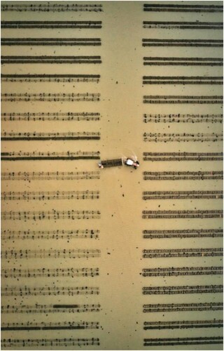
It is only when our eyes are drawn to the tractor and trailer in the centre of the image that the moment of ‘fantasy’ is suspended and it becomes apparent that the ‘sheet music’ or ‘barcode’ is, in fact, a working oyster farm. The movement of the tractor’s wheels generates ripples in the water, disrupting the smoothness of the backdrop and the still life effect of the image, and pulling us back to reality in which human activity (in this case, oyster farming) is responsible for shaping and altering the surrounding environment, i.e. moving back from ‘decontextualised emplacement’ to ‘contextualised emplacement’ (Scollon and Scollon Citation2003, 145). The way that composition alters our interpretation of the image exemplifies how focus, exposure and framing all play an integral role in promoting discourses of truth in images (Kress and van Leeuwen Citation1996, 154). This has important implications for our understanding of the top-down view as it shows how, when used by hobbyists for artistic purposes, it can encourage a reimagining of verticality as a more democratic and creative performance through which knowledge and truth claims are reorganised (Monahan Citation2018; Mangold and Goehring Citation2019, 25).
A similar example can be seen in . It shows four salt evaporation ponds in Arusha, Tanzania, yet depicted from this vertical perspective, it is extremely difficult to identify what they are, leading us to draw upon our pre-established knowledge of other scenes with similar compositions to try and decipher it (Kress and van Leeuwen Citation1996, 154). Thus, here, the salt ponds could be reimagined as large, marbled canvases, mimicking the endpapers of nineteenth-century leather-bound books. Their swirls of greens, blues and whites may also call to mind images of land and sea in an atlas, as if four individual pages have been torn from the volume and laid down here on the ground. The linear, rectangular shapes of the ponds and their strange colour blend also gives them the appearance of stained-glass windows. Again, the geographical landscape becomes temporarily suspended from reality, leaving it up to the viewer to piece together meaning from the less abstract elements surrounding the main image (e.g. houses, trees, roads) to try and make sense of what they see and where it may be located.
FIGURE 2. Abstract Art (Salt Evaporation Ponds in Arusha, Tanzania). Photo reproduced with permission of Maxsim Tarasov.
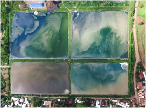
Interpretation is further challenged by the way in which the natural and manmade structures of the image overlap and are blurred into one, which creates a visual conflict as the viewer’s gaze moves between both elements in a bid to interpret them (Ledin and Machin Citation2020, 182). The rectangular ponds and the surrounding buildings, for example, suggest mechanical, technological order associated with the world of human construction (Kress and van Leeuwen Citation1996, 54), but this is offset by the naturally occurring salt patterns within and their bold colours formed by variable algal concentrations. In photographs, ‘pseudo-depth perception’ is typically created by the inclusion of ‘hot’ and ‘cool’ colours, but here, only ‘cool’ colours can be seen – both within the salt pans and in the surrounding fields and trees – which contributes to the challenge of distinguishing where the artificial and natural begin and end (Aber, Marzolff, and Ries Citation2010, 63). The end result is a unique landscape that weaves the organic and manmade together to form a kaleidoscopic image of unusual colours and patterns that provide a new ‘sensory definition of reality’ (Kress and van Leeuwen Citation1996, 165) that is strangely created by geography, yet not bound to it. This, in turn, opens up possibilities for viewers to rethink the creative potentials of drones when used by hobbyists. By straddling the borders between ‘science and art, rationality and imagination, abstracted and embodied knowledge, visibility and invisibility’ (Mangold and Goehring Citation2019), the image ultimately offers a reperspectivisation of the view from above, far more in keeping with genres of landscape architecture and urban design than discourses of dominance and control.
Top-Down Views as Transformations of the Mundane
According to both Scollon and Scollon (Citation2003) and Ledin and Machin (Citation2018), spaces are infused with the dominant discourses in society and these discourses are realised through the materials, colours and textures that are used. However, as the previous examples have shown, the top-down angle of drone visuals has the potential to shake up this regulation of space. While and emphasised how landscapes can become decontextualised and turned into visual metaphors by playing upon physical similarities with everyday objects, in other cases, the regulation of space is shaken up by a deliberate focus on mundane features of the environment, which transforms them into something extraordinary. Here, banal items, such as windmills, cargo boxes and rooftops, remain geographically contextualised and are, therefore, more clearly identifiable and easier to interpret, yet they acquire an aesthetic beauty that transcends their normal meanings and functions when viewed en masse in bright colours and bold patterns. This, in turn, fosters a ‘personalised aerial space’ (Hildebrand Citation2019a, 399) that expands human vision as viewers enhance and remake their existing relationship with their geographical surroundings, thereby encouraging more autonomous engagement with the top-down view.
A clear example of this is , which captures the rooftops of greenhouses in the Russian countryside outside Chelyabinsk. What would be rather nondescript from the ground is turned into a curious sight from above as the top-down view reveals the symmetrical nature of the greenhouses, their repetition in shape, size and colour creating continuity, which gives the image a ‘visual beat’ (Zakia Citation2007, 39). The visual appeal of symmetry lies in the fact that it occurs naturally in the real world (e.g. butterfly wings, honeycombs, petals). Therefore, our brains are not only programmed to recognise it easily, but feel its deep associations with balance, harmony and order (Roos Citation2017). This symmetry, thus, showcases the greenhouses in such a way that they are not clearly stratified, nor correlated with typical human embodiment (Christiansen Citation2020, 296). Rather, the vertical perspective is presented here as a new form of relational experience in which viewers are encouraged to embody the image and, thus, gain control over what they see (McCosker Citation2015).
FIGURE 3. Transformation of Mundane (Greenhouses in Chelyabinsk, Russia). Photo reproduced with permission of Maxsim Tarasov.
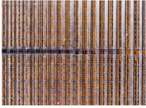
These new emotions generated by the top-down view are further emphasised by the textural quality of the image, the rows of glass connoting feelings of transparency, honesty and openness (Ledin and Machin Citation2018, 94–95). Moreover, the shimmer of sun rays bouncing off the glass, coupled with the greenhouse’s bold orange hue, create feelings of enlightenment and happiness, but also a flare of mystery. This mystery is accentuated by the interspersed lines of green that tantalisingly reveal the plants growing inside, as well as the colour spectrum of the central walkway whose refracted light runs from deep burgundy through red to amber. This emphasis on colour and texture encourages a reorganisation of the geographical space in terms of tactility, which allows a new sensory formation to be enacted with the drone as a partner rather than as a medium of control (Christiansen Citation2020, 296). The image’s composition, thus, turns the ordinary sight of a greenhouse into a multisensorial experience that offers flexibility in perceptions of drone vision and encourages a ‘more-than-optical’ feeling that introduces new ways to think both about the top-down view and our terrestrial surroundings (Agostinho, Maurer, and Veel Citation2020, 251).
Likewise, the top-down angle in transforms the everyday mundane view of rows of cars in Togliatti, Russia into a visually stimulating spectacle. Particular attention is given to the symmetry in the composition: five straight vertically-facing roads and all cars appear the same size at equal distance from one another and turned towards the horizontal axes. Kress and van Leeuwen (Citation1996, 79) describe this type of image as a ‘covert taxonomy’ because it emphasises equivalence between all elements as part of a classificational process. Even though there are challenges to the symmetrical harmony (e.g. different coloured cars, misparked cars, people walking to their spaces), our eyes are automatically drawn to parts of the image where similar items are grouped together in a continuous fashion (Zakia Citation2007, 50). This creates distinct frames that separate ‘order from chaos’ (Ledin and Machin Citation2020, 59), bringing an overall sense of coherence to the image. The top-down view is, therefore, imbued with objective meanings of stability and timelessness – meanings that would not be apparent from ground level.
FIGURE 4. Transformation of Mundane (Car Park in Togliatti, Russia). Photo reproduced with permission of Maxsim Tarasov.
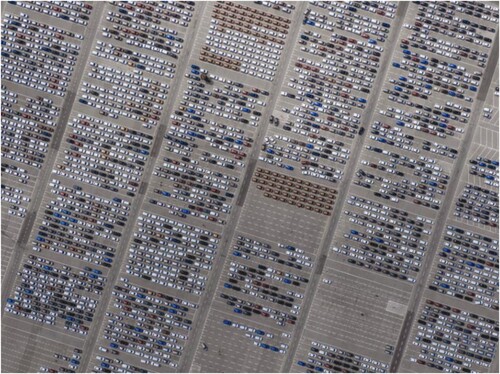
Although people are included in the image, their presence as indistinct dots on the landscape makes it clear that the drone is not interested in them; rather, it is focused on the broader panorama and the shapes/patterns created by this top-down angle, which challenges the persisting connections between drones and surveillance/privacy concerns. Here, the drone camera, the data it produces and the wider practices and infrastructures through which it operates form an assemblage that produces a new mode of perception that challenges the notions that seeing is centred and all images are human made (Azar, Cox, and Impett Citation2021). In other words, the way we see things and the meanings we ascribe to them (i.e. their visuality) are affected by what we know or what we believe. However, when mundane scenes are presented from new perspectives, this can often result in new, distributed and sometimes contradictory forms of knowledge (Berger Citation2001, 8). Thus, the image works in two ways: as a ‘suggestive symbolic process’ (Kress and van Leeuwen Citation1996, 106) that serves to create a pleasing mood or atmosphere, but also as a ‘narrative process’ (ibid, 60) that tells the story of modernity, industrialisation and busy urban life through an aestheticisation of the mundane.
Top-Down Views as Playful Mapping
Other top-down images are less concerned with the abstract and artistic functions of the vertical perspective and more oriented towards capturing a particular landmark within its surrounding geographical location. This ‘emplacement’ (Scollon and Scollon Citation2003) – to use geosemiotic terms – is crucial in the construction of the whole meaning of a sign and, when viewed from above, encourages a form of ‘playing mapping’ (Verhoeff Citation2013) based around interactivity and performativity because viewers are placed into the position of sight that the camera occupies. In this way, viewers are not only given the opportunity to experience their ‘desire for navigation’ (ibid) without physically having to move through a geographical space to do so, but they are empowered to take a leading role in the image, thus achieving ‘countervisuality’ as they intrude onto the ‘all-seeing’ eye (Monahan Citation2018). The top-down view, therefore, presents a dense material encounter between the drone, technology and the environment, directly involving viewers and transforming the drone from a hierarchical apparatus into a co-maker of visual material in a narrative process (Mikkola Citation2020, 208).
, which shows a powerful image of the Maheno shipwreck on Fraser Island in Australia, is a characteristic example of how the top-down view can be used performatively. The Maheno was driven ashore by a cyclone in 1935 and has remained in its current position ever since, slowly corroding and prohibited to access due to possible exploded ordnance contamination (Australian Department of Defence Citation2010). However, from the sky, viewers are able to access this ruin from a safe, unrestricted distance, making the site approachable and offering a sense of intimacy as a window is opened onto this ocean liner (Ledin and Machin Citation2020, 50). Seeing the ship within its broader geographical context encourages viewers to engage in ‘playful mapping,’ shattering the assumption of stability implied in the concept of cartography and opening up room to develop new understandings of the relationship between the top-down angle, knowledge systems and cultural forms (Verhoeff Citation2012, 140). Drawing on interpersonal rather than ideational meaning (Kress and van Leeuwen Citation1996, 155), viewers use the subtle visual cues to construct their own meanings of the image. In other words, the image does not express one absolute truth or falsehood (as traditional maps seek to do); rather, it produces multiple shared truths embedded in sensorial rather than purely visual experiences (Agostinho, Maurer, and Veel Citation2020, 251). These truths, however, can only ever be part of an imaginary because they are not possible within the unmediated range of human vision (Wilkinson Citation2013, 10).
FIGURE 5. Performative Mapping (Taheno Shipwreck, Fraser Island, Australia). Photo reproduced with permission of Alessio Borriero.
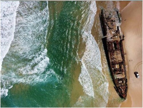
The Maheno’s position on the shore and its long fish-like hull (122 m in length), for example, lead us to make connections in our mind and reimagine it as the familiar image of a beached whale. This likeness is further emphasised by the rusted interior of the ocean liner, which gives it the appearance of a rotting carcass, gradually revealing the skeleton below its flesh. The white car on the bottom right of the image also adds to this mental representation, reminiscent of the police patrol cars often present during cetacean stranding. The image is made even more striking by the contrast in colour and texture between the two sides of its frame. On the left is the rippling turquoise water with white frothy waves, while on the right is the golden, calm sands, stagnant as if time has stood still around the corroding ship/dying whale (Ledin and Machin Citation2020, 104). There is a strong association in the public consciousness between wetness and life/vitality and dryness and rot/decay (ibid, 157), which further adds to the poignance of this metaphorical image. The way that the water gradually intrudes onto the sand and splashes over the back of the Maheno interconnects both elements and signals a ‘bleeding’ of meaning (ibid, 182). In this case, the defiance of spatial boundaries visually indicates the power of the ocean and that, one day, the Maheno/beached whale may be reclaimed by nature. Despite these elements of visual metaphor, it is the clear emplacement of the image – i.e. the broader geographical landscape in which it is embedded – that prevent it from becoming fully metaphorical in the way that and are. Here, its artistic potential is secondary to its cartographic function, the image serving as a form of ‘situated’ knowledge that unfolds both through and within particular timespaces based on spatiotemporal setting (Dodge, Kitchin, and Perkins Citation2009, 321). The aerial perspective, therefore, provides a space for elements of the bottom-up (e.g. the ocean) to showcase their own power and counter the supposedly dominant perspective of the view from above. This, in turn, facilitates an ontogenic world of imagination, far removed from associations with surveillance and warfare, creating an open space that encourages us to rethink how we see our surroundings (Mangold and Goehring Citation2019, 25).
A similar form of playing mapping can be seen in , which depicts the Maze of Honor in the Museum of History in Granite, California (USA), yet from a seldom-before-seen perspective. From this angle, viewers obtain a clear understanding of the geographical landscape, as attention is drawn to features that are impossible to notice at ground level, such as areas where the ground is more trodden (reflecting the most visited parts of the maze), directions that visitors walk (identified from footprints) or the octagonal enclosure around the structure. Thus, through the top-down angle, colour, light and framing guide the mobility of the viewer’s gaze in the style of nineteenth-century dioramas or phantom rides as they follow the maze from start to finish (Verhoeff Citation2012, 47). In this way, the image becomes both a view and a mise-en-scene: it offers up a photo that can be seen at a glance, while simultaneously indicating that its unfolding (and, therefore, its meaning) occurs over time. Like , the image is, therefore, not just a planar 2D representation of a landscape in traditional cartographic style, but rather a form of ‘situated’ knowledge that is ‘mobile and mutable, polychronic and multitemporal’ (Shep and Owen Citation2019).
FIGURE 6. Performative Mapping (Maze of Honor, Granite, California, USA). Photo reproduced with permission of Eric Hanscom.
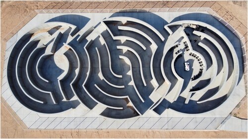
Another important aspect of performative cartography is its ability to pinpoint symbolic features of the landscape. While the top-down angle reveals how the octagon acts as a physical border that separates the desert sand from the maze, it also accentuates its symbolism: octagons have a long historical association with renewal, rebirth, regeneration and transition, which stems from the shape of baptismal fonts, as well as ‘eight’ signifying cosmic equilibrium and immortality in medieval number symbolism (Kappraff Citation2003, 127). As the Maze of Honor was built for people to place memorials of loved ones in granite on its walls, this symbolism is intentional, yet can be easily overlooked from the ground. Thus, these symbolic features conform to the principle of ‘indexicality’ (Scollon and Scollon Citation2003), where every sign has its meaning, but this meaning is only given to a sign by the specific place that it is put. In other words, to view the octagon in a different context would infuse it with very different meanings (e.g. the octagon-shaped Dome of the Rock in Jerusalem, the octagon-shaped cage in a mixed material arts tournament). Seen in this light, the physical position of the octagon, forming a border between the maze and the outside desert, also adds to the effect that the maze is a singular space, almost suspended from time. However, the elements of sand that have creeped into the maze in places give a ‘bleeding’ of meaning (Ledin and Machin Citation2020, 182), their intrusion visually indicating the futile battle between life and death. This ‘dialogicity’ (Scollon and Scollon Citation2003) between the image and the signs that surround it turns the top-down view into a ‘scripting of performance’ (Verhoeff Citation2012, 42) as viewers are guided to look, move and understand what is seen through spatial composition. Dialogicity, thus, ensures that once the signs are out in the world, they are ‘no longer under the sole semiotic sovereignty of the placer’; rather, they are part of an ‘ecology of signs’ (Archer and Collins Citation2021). This, in turn, produces a highly emotional experience that stands in contrast to the typical purpose of cartography, as well as the negative feelings often provoked by the view from above.
Top-Down Views as Dronies
According to Jocuns (Citation2021), the meanings that people ascribe to a space allow it to take on the role of actor. This is particularly apparent in dronies: self-portraits from the air that combine the ‘aesthetic characteristics of the selfie and of aerial videography’ (Jablonowski Citation2017, 99). While normal selfies are considered to be embodied and gestural, the dronie ‘abstracts from the individual’ (Richardson Citation2020) by accentuating physical space rather than the people in the physical space. In doing so, the photographed gain control of how they are viewed from above, transferring the symbolic power of place to a concrete spatial context (Lou Citation2017) rather than the sky, which renders the top-down view as a modality of self-making rather than a potential form of privacy invasion. As Lyon and Bauman (Citation2013, 23) note, in many ways, the dronie has demilitarised and democratised the drone by removing it from the context of surveillance and warfare and turning the condition of being watched ‘from a menace into a temptation.’ This reappropriation imbues the drone with a touch of playfulness and brings about a sense of empowerment as it is used as an ‘ego-technical’ rather than a ‘xeno-technical’ device that actively develops one’s self across social, technological and media settings (Solterdijk, cited in Jablonowski Citation2017, 99–100).
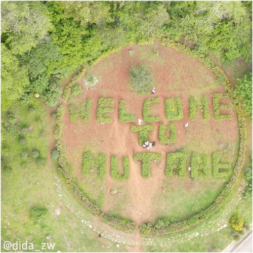
A clear example of how the dronie democratises the top-down view and gives participants charge over their own geographical space can be seen in , which was taken in Zimbabwe and shows a group of residents standing in a landscaped circle that states ‘WELCOME TO MUTARE’. The adults and children lift their heads to the sky above, some posing for the camera in acknowledgement of being observed. In doing so, they form an eyeline vector, taking part in a ‘non-transactional reaction’ (Kress and van Leeuwen Citation1996, 74) that enables them to ‘hijack surveillance’ (Jablonowski Citation2017, 103). While the upward-directed gaze of the crowd acts as a form of visual direct address that ‘demands’ (Kress and van Leeuwen Citation1996, 118) something from the drone operator, the camera is more concerned with capturing the patterns of the landscape rather than the individuals themselves or, as Tagesschau (2015; cited in Jablonowski Citation2017, 102) puts it, ‘panoramas rather than noses.’ In other words, cinematic views are foregrounded with the camera ascending away from the people in a zoom-out effect. This means that little attention is paid to their gestures, facial expressions and appearance, thereby reversing the relationship between humans and their surroundings found in typical selfies. These aesthetics also disrupt our understanding of traditional image acts and gaze because, despite the participants forming eyeline vectors indicative of an act of demand, they instead operate as abstract still life images with a dense, three-dimensional sense (Kress and van Leeuwen Citation1996, 117). This encourages viewers to engage deeper with their inclusion in the image and, thus, interact with the top-down view in new ways that threaten the stability of its meanings, pushing its boundaries as our geographical imaginations and understanding of the world are reshaped (Brighenti and Pavoni Citation2021, 430).
FIGURE 7. Dronie (Mutare, Zimbabwe). Photo reproduced with permission of Tinashe Mulambo.
Even in dronies when subjects are not conscious of their presence in a photograph, the top-down view cannot be simply classified as invasive and meddlesome; instead, it must be considered as a way of cleverly turning physical space into the chief actor, almost personifying it, with the participants themselves gaining secondary roles. A clear example of this is the image in , which captures two men braving the elements to row in the English Channel just off the coast of Jersey. The two figures in the boat have their heads bowed and their faces show signs of exertion as they row, unaware of the drone flying overhead. However, it is apparent that the drone camera is not interested in the people themselves, but rather how their framing adds to the general panorama of the image and evokes a certain mood. Unlike typical selfies, the dronie’s focus is on the men’s position within the landscape rather than their individual features. Its framing, thus, serves to build strong emotions in viewers as they are forced to experience the water from a close-up perspective with no sky or land to help orient them (Kress and van Leeuwen Citation1996, 124). Kress and van Leeuwen (Citation1996, 106) describe this image as ‘suggestive symbolic’ because the participants (e.g. the Carriers) are deemphasised in favour of an ‘atmosphere,’ meaning that a ‘generalised essence’ is conveyed rather than a ‘specific moment.’
FIGURE 8. Dronie (English Channel). Photo reproduced with permission of Paul Lakeman.
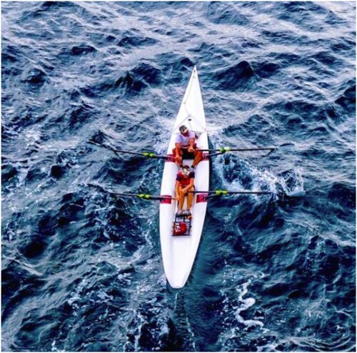
Attention is drawn to the choppy waves and their menacing dark blue colour, which turns them into small-scale versions of mountainous peaks surrounded by storm clouds. This perspective emphasises the texture of the landscape, creating a strong sensory experience in which the textural is just as important as the visual in producing meaning-making and imbuing the image with the quality of a moving picture (Ledin and Machin Citation2020, 153). Tension is created by the contrast between the intimidating water and the men in the white boat – a symbol of innocence and purity (Kress and van Leeuwen Citation2002, 348) – which adds a heightened sense of danger to the image. Thus, here, meaning and identity come from within, deriving from the qualities of the Carrier rather than purely the landscape. Without the men’s presence, the choppy water would not have the same sense of drama; their presence makes us as viewers feel concern for their safety as they row in this turbulent water. The image, therefore, shows how dronies taken from top-down angles are encouraging a reappraisal of traditional meanings of verticality and promoting new understandings of how we imagine and engage with our geographical surroundings (Monahan Citation2018).
Conclusion
In recent years, the rise of off-the-shelf drones and their growing deployment outside of military contexts has started to challenge and disrupt traditional meanings associated with the view from above. This is particularly the case for hobby drones, which enable civilian users to develop their photography skills and capture innovative images with the aim of changing the way that we see the world and perceive our surroundings (Serafinelli and O’Hagan Citation2022). Applying a geosemiotics perspective to the study of top-down views produced by drone hobbyists has revealed four unique functions of this type of image – as abstract art, as transformations of the mundane, as performative mapping and as dronies – all of which bolster new understandings of the link between verticality and power. Furthermore, it has revealed that the relationship between visual semiotics and place semiotics varies according to the function of the top-down view in order for meaning-making to be conveyed successfully.
Top-down views as abstract art, for example, rely on a detachment and decontextualised emplacement; it is only through their operation in a liminal space that their visual metaphors can be presented and decoded by viewers who draw upon visual similarities with objects in their everyday lives to interpret what they see. Top-down views as transformations of the mundane, on the other hand, rely on contextualisation within their geographical setting; the deliberate recognition of banal items yet arranged in new ways (e.g. symmetrical, colour-coordinated patterns) grants them an extraordinary aesthetic beauty and creates a new sensory formation with the geographical space in terms of tactility rather than pure visuality. Top-down views as performative mapping are strongly linked with emplacement, their familiar cartographic structure drawing on situated knowledge to make meaning. However, unlike normal maps, this situated knowledge is mobile and mutable, subject to temporal changes and often charged with emotions due to the semiotic constructs of the image (e.g. colour, texture, layout, composition). These views also rely most heavily on the concepts of indexicality and dialogicity: meaning is granted to the signs based on their geographical location and these meanings are constantly co-constructed between the image, the signs that surround it and the viewers who interpret it. Finally, top-down views as dronies pose a challenge to traditional associations of the vertical angle with surveillance, as well as traditional notions of image act and gaze because the participants are generally aware of their presence in the photo, but are secondary to the geographical space in which they are presented. In other words, despite the participants’ central position and eyeline vectors in such images, it is the space itself that becomes the social actor through the use of ascending cinematic views, clever framing and colour/textural contrasts. However, the specific mood of the image depends on the participants’ presence because meaning and identity derive from within them and how they relate to the landscape; without them, the process of dialogicity would change and certain connotations would be lost.
Despite the differing functions of the top-down view in drone hobbyist visuals, the common characteristic that unites them is that the drone photographer’s attention is focused entirely on the compositional arrangement of the image over any other factor. Emphasis is placed chiefly on the colours, patterns and textures of the landscape and how these features can be harnessed from a vertical perspective to produce new knowledge through aesthetically pleasing images. This is underlined by the lack of horizon in photographs, which encourages viewers to engage deeper with the image as they try to make sense of what they see. Furthermore, even when people are present in photographs, drone users are not interested in capturing their faces, but rather the shapes that their bodies make or the emotional impact of the contrast between humans and nature. Thus, top-down images tend to sit on the boundary between reality and fiction and it is the space in these imaginary worlds that gives room to shifting perspectives on verticality. In many cases, the top-down view acquires a feeling of playfulness as viewers are encouraged to embody the images and, in doing so, develop their own personalised aerial spaces that remake their existing relationships with the world around them. Seeing, therefore, becomes a performance tied up with both symbolic and narrative processes and has the potential to produce countervisuality as everyday features of a landscape acquire powerful, new meanings that reshape the view from above.
These findings encourage us to think beyond the drone as an object and see it instead as a ‘complex material assemblage of the sky’ (Crampton Citation2016, 137) because it has the ability to extend our perception, modify our geographical imaginations and, thus, multiply our possible interpretations of the top-down view (Garrett and Anderson Citation2018). Drone hobbyist visuals make it clear that verticality is not simply ocular or visual; instead, it consists of multiple complex practices, materials and representations that help democratise the three-dimensionality of the world (Jensen Citation2020). Top-down views move the line of sight from the street to the air, but this does not have to entail a relocation of the boundaries between public and private. When used by hobbyists, drones acquire new realities and take on new demilitarised meanings, disrupting our understanding of everyday environments and, thus, opening a reflective space to untangle the link between the view from above and systems of control (Hildebrand Citation2019b). This does not mean creating a utopian image or denying that the top-down view can be problematic, particularly when used in unregulated ways, but it does foster room for more critical reflection of the social, cultural, historical and political connotations of such perspectives. Overall, an examination of drone hobbyist visuals makes it clear that the top-down view is not centred, singular or representative of an indexical truth or reality; rather, it has a range of new, creative and rebellious forms that cultivate multiple lifeworlds (Azar, Cox, and Impett Citation2021).
DATA
Data supporting this study are included within the article. The full dataset is currently not publicly available due to ethical reasons.
DISCLOSURE STATEMENT
No potential conflict of interest was reported by the author(s).
Correction Statement
This article has been corrected with minor changes. These changes do not impact the academic content of the article.
Additional information
Funding
Notes on contributors
Lauren Alex O’hagan
Lauren Alex O’Hagan Örebro University, School of Humanities, Education and Social Sciences, Department of Media and Communication Studies, Fakultetsgatan 1, 702 81, Örebro, Sweden. The Open University, Faculty of Wellbeing, Education and Language Studies, Walton Hall, Kents Hill, Milton Keynes MK7 6AA.
Elisa Serafinelli
Elisa Serafinelli Manchester Metropolitan University, iSchool, Rosamond St W, Manchester M15 6EB.
References
- Aber, J. S., I. Marzolff, and J. Ries. 2010. Small-Format Aerial Photography: Principles, Techniques and Geoscience Applications. Amsterdam: Elsevier.
- Adams, C. 2019. “Tinker, Tailor, Soldier, Thief: An Investigation into the Role of Drones in Journalism.” Digital Journalism 7 (5): 658–677. doi:10.1080/21670811.2018.1533789.
- Agostinho, D., K. Maurer, and K. Veel. 2020. “Introduction to The Sensorial Experience of the Drone.” The Senses and Society 15 (3): 251–258. doi:10.1080/17458927.2020.1820195.
- Al Zydjaly, N. 2014. “Geosemiotics: Discourses in Place.” In Interactions, Images and Texts, edited by S. Norris, and C. D. Maier, 63–77. Berlin: De Gruyter.
- Amad, P. 2012. “From God’s-eye to Camera-eye: Aerial Photography’s Post-humanist and Neo-humanist Visions of the World.” History of Photography 36 (1): 66–86. doi:10.1080/03087298.2012.632567.
- Archer, H., and E. Collins. 2021. “Geolocating Obama Hope: Virtual Geosemiotics and Context Dependent Meaning.” In Doing Digital Visual Studies: One Image, Multiple Methodologies, edited by L. E. Gries, and B. Hallinan. https://ccdigitalpress.org/book/ddvs/chapters/archer-collins/introduction.html
- Arthus-Bertrand, Y. 2001. Earth from the Air. London: Thames and Hudson.
- Australian Department of Defence. 2010. List of UXO Contamination Sites in Queensland, https://www.defence.gov.au/uxo/drn_reports/summary_state.asp?State=QLD.
- Azar, M., G. Cox, and L. Impett. 2021. “Introduction: Ways of Machine Seeing.” AI & Society, https://link.springer.com/article/10.1007s00146-020-01124-6.
- Benjamin, G. 2020. “Drone Culture: Perspectives on Autonomy and Anonymity.” AI & Society, https://link.springer.com/article/10.1007s00146-020-01042-7.
- Berger, J. 2001. About Looking. London: Vintage Books.
- Bracken-Roche, C. 2016. “Domestic Drones: The Politics of Verticality and the Surveillance Industrial Complex.” Geographica Helvetica 71: 167–172. doi:10.5194/gh-71-167-2016.
- Brighenti, A. M., and A. Pavoni. 2021. “Vertical Vision and Atmocultural Navigation. Notes on Emerging Urban Scopic Regimes.” Visual Studies 35 (5): 429–441. doi:10.1080/1472586X.2020.1840089.
- Christiansen, S. L. 2020. “Unruly Vision, Synesthetic Space: Drone Music Videos.” The Senses and Society 15 (3): 286–298. doi:10.1080/17458927.2020.1814565.
- Corner, J. 1996. Taking Measures Across the American Landscape. New Haven: Yale University Press.
- Cosgrove, D., and W. L. Fox. 2010. Photography and Flight. Chicago: University of Chicago Press.
- Crampton, J. W. 2016. “Assemblage of the Vertical: Commercial Drones and Algorithmic Life.” Geographica Helvetica 71: 137–146. doi:10.5194/gh-71-137-2016.
- Del-Real, C., and A. M. Díaz-Fernández. 2021. “Lifeguards in the Sky: Examining the Public Acceptance of Beach-Rescue Drones.” Technology in Society, doi:10.1016/j.techsoc.2020.101502..
- Dodge, M., R. Kitchin, and C. Perkins. 2009. “Mapping Modes, Methods and Moments: A Manifesto for map Studies.” In Rethinking Maps: New Frontiers in Cartographic Theory, edited by M. Dodge, R. Kitchin, and C. Perkins, 311–341. London: Routledge.
- Frankelius, P., C. Norrman, and K. Johansen. 2019. “Agricultural Innovation and the Role of Institutions: Lessons from the Game of Drones.” Journal of Agricultural and Environmental Ethics 32: 681–707. doi:10.1007/s10806-017-9703-6.
- Garrett, B., and K. Anderson. 2018. “Drone Methodologies: Taking Flight in Human and Physical Geography.” Transactions of the Institute of British Geographers 43: 341–359. doi:10.1111/tran.12232.
- Garrett, B., and A. McCosker. 2017. “Non-Human Sensing: New Methodologies for the Drone.” In Refiguring Techniques in Digital Visual Research, edited by E. Gómez Cruz, S. Pink, and S. Sumartojo, 13–23. London: Palgrave Macmillan.
- Grayson, K., and J. Mawdsley. 2018. “Scopic Regimes and the Visual Turn in International Relations: Seeing World Politics Through the Drone.” European Journal of International Relations 25 (2): 431–457. doi:10.1177/1354066118781955.
- Greene, D. 2015. “Drone Vision.” Surveillance & Society 13 (2): 233–249. doi:10.24908/ss.v13i2.5346.
- Haraway, D. 2007. When Species Meet. Minneapolis: University of Minnesota Press.
- Hildebrand, J. M. 2019a. “Consumer Drones and Communication on the fly.” Mobile Media & Communication 7 (3): 395–411. doi:10.1177/2050157919850603.
- Hildebrand, J. M. 2019b. “Drone-topia as Method.” Mobilities 15 (1): 25–38. doi:10.1080/17450101.2019.1663079.
- Hildebrand, J. M. 2020. “Drone Mobilities and Auto-technography.” In Handbook of Research Methods and Applications for Mobilities, edited by M. Büscher, M. Freudendal-Pedersen, S. Kesselring, and N. Grauslund Kristensen, 92–101. Cheltenham: Edward Elgar Publishing.
- Hollman, V. C. 2020. “Drone Photography and the Re-aestheticisation of Nature.” In Decolonising and Internationalising Geography, edited by B. Schelhaas, et al. Berlin: Springer. doi:10.1007/978-3-030-49516-9_6.
- Jablonowski, M. 2017. “Dronie Citizenship.” In Selfie Citizenship, edited by A. Kuntsman, 97–106. London: Springer.
- Jablonowski, M. 2020. “Beyond Drone Vision: The Embodied Telepresence of First-person-view Drone Flight.” The Senses and Society 155 (3): 344–358. doi:10.1080/17458927.2020.1814571.
- Jensen, O. B. 2020. Thinking with the Drone – Visual Lessons in Aerial and Volumetric Thinking. doi:10.1080/1472586X.2020.1840085.
- Jocuns, A. 2021. “The Geosemiotics of a Thai University: The Narratives Embedded in Schoolscapes.” Linguistics and Education 14. doi:10.1016/j.linged.2021.100902.
- Kaplan, C. 2018. Aerial Aftermaths: War Time from Above. Durham and London: Duke University Press.
- Kappraff, J. 2003. Beyond Measure. Singapore: World Scientific Publishing.
- Kress, G., and T. van Leeuwen. 1996. Reading Images: The Grammar of Visual Design. London: Routledge.
- Kress, G., and T. van Leeuwen. 2002. “Colour as a Semiotic Mode: Notes for a Grammar of Colour.” Visual Communication 1 (3): 343–368. doi:10.1177/147035720200100306.
- Ledin, P., and D. Machin. 2018. Doing Visual Analysis: From Theory to Practice. London: SAGE.
- Ledin, P., and D. Machin. 2020. Introduction to Multimodality. London: SAGE.
- Lou, J. J. 2017. “Spaces of Consumption and Senses of Place: A Geosemiotic Analysis of Three Markets in Hong Kong.” Social Semiotics 27 (4): 513–531. doi:10.1080/10350330.2017.1334403.
- Lyon, D., and Z. Bauman. 2013. Liquid Surveillance. New York: John Wiley and Sons.
- Mangold, E. B., and C. Goehring. 2019. “The Visual Rhetoric of the Aerial View: From Surveillance to Resistance.” Quarterly Journal of Speech 105 (1): 25–41. doi:10.1080/00335630.2018.1553305.
- Massey, D. 2007. For Space. London: SAGE.
- Maurer, K. 2016. “Visual Power: The Scopic Regime of Military Drone Operations.” Media, War and Conflict 10 (2): 141–151. doi:10.1177/1750635216636137.
- McCosker, A. 2015. “Drone Media: Unruly Systems, Radical Empiricism and Camera Consciousness.” Culture Machine 16. https://culturemachine.net/vol-16-drone-cultures/drone-media/.
- McCosker, A., and R. Wilken. 2020. Automating Vision: The Social Impact of the New Camera Consciousness. London: Routledge.
- Mikkola, H. 2020. “In the Wings of the Dove: Bird's-eye View and More-than-human Gaze in the Wildlife Documentary Series Earthflight.” Studies in Documentary Film 14 (3): 202–215. doi:10.1080/17503280.2019.1651481.
- Millner, N. 2020. “As the Drone Flies: Configuring a Vertical Politics of Contestation Within Forest Conservation.” Political Geography, doi:10.1016/j.polgeo.2020.102163.
- Monahan, T. 2018. “Ways of Being Seen: Surveillance Art and the Interpellation of Viewing Subjects.” Cultural Studies 32 (4): 560–581. doi:10.1080/09502386.2017.1374424.
- Muthyala, J. 2019. “Drones and Surveillance Cultures in a Global World.” Digital Studies/Le champ numérique 9 (1): 1–51. doi:10.16995/dscn.306.
- Pauschinger, D., and F. R. Klauser. 2020. “Aerial Politics of Visibility: Actors, Spaces, and Drivers of Professional Drone Usage in Switzerland.” Surveillance and Society 18 (4): 443–466. doi:10.24908/ss.v18i4.13434.
- Pink, S. 2007. Doing Visual Ethnography. London: SAGE.
- Pong, B. 2019. “Henry Green's Pigeons.” Modernism/Modernity 4 (3), https://modernismmodernity.org/articles/pong-henry-greens-pigeons. doi:10.1353/mod.2020.0044.
- Pugliese, J. 2019. “As Above so Below: Drone Visualities of the Aftermath, Testimonies of the More-Than-Human and the Politico-Aesthetics of Massacre Sites.” Social Identities 25 (4): 457–475. doi:10.1080/13504630.2018.1514159.
- Richardson, M. 2020. “Drone Cultures: Encounters with Everyday Militarisms.” Continuum: Journal of Media & Cultural Studies. doi:10.1080/10304312.2020.1842125.
- Roos, D. 2017. “Why do We get so Much Pleasure from Symmetry?” How Stuff Works https://science.howstuffworks.com/why-do-get-so-much-pleasure-from-symmetry.htm.
- Sandvik, K. B., and M. G. Jumbert. 2016. The Good Drone. London: Routledge.
- Sandvik, K., and K. Lohne. 2014. “The Rise of the Humanitarian Drone: Giving Content to an Emerging Concept.” Millennium 43 (1): 145–164. doi:10.1177/0305829814529470.
- Scollon, R., and S. Scollon. 2003. Discourses in Place: Language in the Material World. London: Routledge.
- Serafinelli, E., and L. A. O’Hagan. 2022. “Drone Views: A Multimodal Ethnographic Perspective.” Visual Communication, doi:10.1177/14703572211065093.
- Shep, S., and R. Owen. 2019. “Unexpected Connections: Reimagining the Nineteenth Century Through Generative Art.” Open Library of Humanities 5: 1. doi:10.16995/olh.220.
- Stankov, U., J. Kennell, A. M. Morrison, and M. D. Vujičić. 2019. “The View from Above: The Relevance of Shared Aerial Drone Videos for Destination Marketing.” Journal of Travel & Tourism Marketing 36 (7): 808–822. doi:10.1080/10548408.2019.1575787.
- Thompson, J. B. 2005. “The New Visibility.” Theory, Culture & Society 22: 31–51. doi:10.1177/0263276405059413.
- Tuck, S. 2018. “Drone Vision and Protest.” Photographies 11 (2–3): 169–175. doi:10.1080/17540763.2018.1445020.
- Verhoeff, N. 2012. Mobile Screens: The Visual Regime of Navigation. Amsterdam: Amsterdam University Press.
- Verhoeff, N. 2013. “You Are Here! Playful Mapping and a Cartography of Layers.” In Proceedings of the 26th Cartographical Conference, edited by M. F. Buchroithner, N. Prechtel, D. Burghardt, K. Pippig, and B. Schröte, 1–11. Dresden: International Cartographic Association.
- Waghorn, N. J. 2016. “Watching the Watchmen: Resisting Drones and the “Protester Panopticon.”.” Geographica Helvetica 71 (2): 99–108. doi:10.5194/gh-71-99-2016.
- Weizman, E. 2017. Forensic Architecture: Violence at the Threshold of Detectability. New York: Zone Books.
- Wilkinson, J. 2013. “Animalizing the Apparatus: Pigeons, Drones and the Aerial View.” SHIFT 6: 1–21.
- Zakia, R. 2007. Perception and Imaging: Photography–A Way of Seeing. London: Taylor & Francis.
- Zuev, D., and G. Bratchford. 2020. The Citizen Drone: Protest, Sousveillance and Droneviewing. doi:10.1080/1472586X.2020.1843285.