Abstract
This article aims to contribute to the international research on the relationship between the child and the city, based on drawings and interviews collected from 4th grade children in a socially mixed gentrified neighbourhood of Paris. Its ambition is to reflect on the methodological contribution of drawings to analyse the children's representation of the neighbourhood. In doing so, the article also presents the principal facets of a gentrified Parisian district as perceived by the children themselves, by studying to what extent children's gender and diverse social backgrounds impact their neighbourhood representations and experiences.
Introduction
Children studies developed considerably in many northern countries starting in the 1970s, and particularly since the 1990s. The question of the relationship between children and their area, their city especially, has been the subject of considerable research (Lynch Citation1977, Aitken Citation1994, McKendrick Citation1999, Holloway and Valentine Citation2000, Chawla 2002). On the contrary, in French social sciences this question has rarely been touched on (Danic et al. Citation2010). Research regarding the urban experiences of non-adult individuals has focused primarily on the working-class youth from the estates of the banlieues (Lepoutre Citation2001, Beaud Citation2002, Kokoreff Citation2003). And yet in the 1970s, Marie-José Chombart de Lauwe and her team had carried out a very shrewd study on the relationship between children aged 6 to 14 and their neighbourhoods and towns, in an old district of Paris, in new town neighbourhoods, and in a remote rural village (Chombart de Lauwe Citation1977). But this research, pioneering as it was, did not inspire others in France. Only a few works, produced by psychologists, at times in conjunction with geographers, have more recently analysed the urban mobility of children, but from a perspective heavily centred on the question of the child's autonomy and development (Depeau 2008, Legendre 2010, Enaux and Legendre 2010). This article, based on a Paris case study, therefore aims to develop the contribution of the French social sciences to the international research on the relationship between the child and the city.
More specifically, it presents the first results of a research that aims to compare the urban experience of children (and of their parents) from three gentrified neighbourhoods of Paris, London, and San Francisco. Gentrified neighbourhoods, which refer to the formerly working-class central districts transformed by the ‘return to the city’ (Bidou Citation2003) of the middle and upper echelons of the population (Glass 1964, Lees et al. Citation2008), represent relatively rare examples of socially mixed areas within increasingly segregated central cities. As such, they make special platforms for observation, to study the relationships – symbolic and real – which children from different social backgrounds, cohabiting in the same area, have with the neighbourhood and the city in which they live.
The few researches which have studied the issue of children in the gentrification process and social diversity have exclusively focused on the point of view of the adult ‘gentrifiers’ (Karsten Citation2003, Citation2007, DeSena Citation2009). As the children are social actors in their own right, and as it is established that their perspectives on an area can greatly differ from those of adults (Lynch Citation1977, Valentine Citation2004), it is essential to analyse the child's point of view. How do these children from different social backgrounds perceive the neighbourhood that their parents' residential choices have led them to live in? What use do they make of these neighbourhoods and the city in which they are situated? More specifically, this article seeks to analyse the primary school children's representations of the gentrified Batignolles district in Paris. This is based on material composed primarily of drawings made by the children showing how they perceive their neighbourhood, and subsequent individual interviews with the subjects.
The drawings result from ‘visual methods’. Let us not forget that these were first – and predominantly – developed by environmental psychology researchers, in the same vein as the ‘Place Perception Project’ put in place by James Blaut and David Stea at Clark University in the 1970s. In this perspective, maps, aerial photographs, and sketch maps (produced by the children and analysed according to the principles set out by Kevin Lynch in Citation1960) became special tools for analysing the development of spatial awareness and the terms of spatial cognition amongst the children; they helped establish the variations in the environmental knowledge according to the children's age and sex, while bringing into question the Piagetist hypothesis of the stages of development of the child (Blaut and Stea Citation1971, Hart Citation1979, Matthews Citation1984, Citation1985, Citation1992). These methods were criticised due to the strictness with which the researchers controlled the protocols, which left very little room for the children to express themselves spontaneously, leading to adult-centred interpretations of the spatial representations of the children (Young and Barrett Citation2001). With the emergence of the sociological approach, the research has given greater weight to the perspectives of the children of their living space, to the sense and the values they attribute to the places, and to the kinds of bonds they feel; at the same time it has brought to light the diversity of their experiences according to the socio-spatial context in which they find themselves (Aitken Citation1994, Holloway and Valentine, Citation2000). This trend has been accompanied by a diversification in the methods used in research with children, aiming to give the children the most varied and appropriate means to give their own account of their interpretations of an area. Amongst the numerous methods used, the visual methods have pride of place, drawings, maps, photos, etc., often serving as a basis for individual and collective discussions (Young and Barrett Citation2001, Christensen and O'Brien Citation2003, Béneker et al. Citation2010).
This article's ambition is two-fold. It aims to reflect on the methodological contribution of visual methods, and in particular of the free recall sketch to analyse the children's representation of the neighbourhood: it emphasises its assets and its limits through the confrontation with other sources of information (interviews with the children and with their teacher). In doing so, the article presents the principal facets of the gentrified Parisian district of Les Batignolles as the children represent it (type of landscape and uses, the role of the physical perceptions, variations in the scale of the area) by studying to what extent the class and gender of the participating children can explain the similarities and differences in their representations of the neighbourhood.
Field and methods
The Batignolles neighbourhood, in Paris' 17th arrondissement, is situated between the working-class districts to the north and the middle-class districts to the west: it is widely considered an ‘intermediary’ neighbourhood (Bernard Citation2004), both in the geographic and the social sense. A working-class neighbourhood strongly anchored by the Cardinet goods station in the 1950s, the Batignolles subsequently suffered several decades of demographic and socio-economic decline, before a revival, starting in the 1990s, with growth led by the return to the city of the middle classes. Today it is a densely populated (39,940 inhabitants for 1.44 km2, or 27,740 inhabitants/km2; INSEE 2006 census) and socially heterogeneous neighbourhood: professional and managerial workers make up 39.9% of households, side by side notably with manual workers' households (6.6%), clerical employees (10.6%), and the retired (15.7%), who are for the most part former manual workers or clerical employees themselves. This social diversity is related to the structure of the habitat: in this neighbourhood of modest buildings of five or six storeys in Paris stone, small apartments are still predominant; furnished rentals and social housing also allow accommodation for the less wealthy households. Finally, the structure of incomes gives a good illustration of the social disparity of the neighbourhood's inhabitants, the incomes of the households in the first decile (approximately €90,300) being 10 times greater than those of the last decile (€9,100).
As a gentrified neighbourhood whose inhabitants will happily talk up its ‘village’ character, it has also become (again) a family neighbourhood. After a historic low of 10.7% in 1975, the proportion of children under the age of 15 increased in the 1990s, in correlation with the gentrification process. Today, they make up for 12.5% of the population of the Batignolles neighbourhood (INSEE 2006 census). Moreover, shopkeepers have readily recognised the growing importance of children in the neighbourhood. On Saturday or Sunday mornings, the narrow pavements of the rue des Moines or the alleys of the covered Market can be extremely busy, quickly congested with prams and the patter of tiny feet. In fine weather the density of families and children in the neighbourhood's two parks is extraordinary. Conversely, during the school holidays, the neighbourhood empties and the weekends seem very dreary. And yet the statistics show that only 22.7% of the households are families with children, a relatively small proportion compared to the 17th arrondissement as a whole and to all of Paris. In other words, although the proportion of families with children is relatively low compared to the rest of the district and the city, they are remarkably visible in the day-to-day life of the neighbourhood.
In this neighbourhood, the children whose graphic representations are analysed in this article all belong to a CM1 class (Year 5) of a local state primary school of average size (10 classes from CP to CM2 – the equivalent to Year 2 to Year 6 classes in the British school system). Since in France attendance of elementary state schools depends on catchment areas, these schools are, by definition, neighbourhood schools.Footnote1 Our hypothesis was that, at that age, children (who were aged between 9 or 10 at the time of the study) possess a certain knowledge of their environment, due in particular to relatively independent practices, as well as a basic level of drawing and discursive ability. This age group is also interesting as it precedes the great upheaval of admission to secondary schools. The 27 children in the class, with almost as many girls as boys, are a reflection of the socio-cultural diversity of the rest of the school () and of the neighbourhood: 11 amongst them are from middle class families (their parents, for example, work as lawyers, sound engineers, journalists, teachers, or biologists), whereas 16 other children are from working class families (their parents work in the building trade or the clothing industry or they are caretakers, cleaners, waiters, retired, or unemployed). As in the school as a whole (), most of the parents were born in France, but a significant minority come from other European countries, northern Africa, sub-Saharan Africa, and Asia (with several mixed couples). In short, it is well and truly a socio-culturally mixed class, in line with the rest of the school and the neighbourhood. Note also that almost all the children interviewed have been in this same school since the beginning of elementary school, and have lived in the neighbourhood for as long as they can remember (except four children): in other words, they represent a great residential stability.
Table 1. A socially diverse school: division of children according to family quotient.
Table 2. One school, 21 nationalities: division of children according to nationality.
Having obtained the agreement of the teacher and the parents in the selected class, we organised a ‘neighbourhoodFootnote2 workshop' in May 2009. Having presented to the class our project of ‘better understanding the neighbourhood and how people (adults and children) live in their neighbourhood today’, we distributed sheets of A4 paper with the following instruction: ‘draw your neighbourhood’. This wording, deliberately open, aimed to leave each child the choice of the type and content of his graphic representation. One child asked if it meant making a map or drawing a picture, and we replied to the whole class that it was their choice. Later, we interviewed each child for approximately 15 minutes, in the school library. We started by asking each child to comment on his/her drawing. The discussion then consisted of displaying a set of seven photos of the neighbourhood (the nearby private school, the park, the local library, the shopping street, the market, the metro station, and an urban square deliberately some distance from the previous places), each one corresponding to an open questioning on the recognition, the uses, the sociability, the attachment and the mobility issues related to the specific place.
The drawings produced by the children were analysed according to the method described in a recent article (Béneker et al. Citation2010). The first stage consisted of observing the drawings as a whole, to identify the main themes and the most revelatory examples. Then each drawing was analysed in detail: this consisted, for each theme identified, of studying the precise way in which it was dealt with (or not dealt with) graphically. The individual discussion therefore allowed us to observe the concordance or the discrepancy between the themes of the drawing and those of the interview. Finally, the child's representations (graphic and discursive) were linked to other information obtained from the teacher or possibly an interviewed parent.
How to represent one's neighbourhood?
On first inspection, the great disparity between the 27 neighbourhood drawings is striking, despite them being drawn by children of a similar age living in the same urban area, and the question arises of the very possibility of using them to analyse the children's neighbourhood, which was one of the motivations of the exercise.
‘Detailed’ drawings, ‘sketchy’ drawings
In particular, certain graphic offerings, which we can qualify as ‘sketchy’, seem to offer much less material for analysis (careless outline of the drawing, weakness of detail, and absence of place names) than others, which, conversely, we can qualify as ‘detailed’. Needless to say, it is not this paper's intention to give a value judgement on the quality of the drawings per se, but we argue that the drawings' contents, the number and the nature of their components, are very interesting to analyse. Thus, during the discussions that followed, several children said that they thought their work was incomplete. Constantin,Footnote3 for example, showed the (limited) area between the school and his home. The drawing, lacking in detail, simply shows several shapes which act as buildings. Commenting his drawing, he immediately acknowledges its incomplete nature: ‘So I forgot to put loads of things here because I couldn't remember’. And he proceeds to orally and precisely describe all these places which hadn't come to his mind at the time of the drawing (‘the cafe’, ‘an apartment’, ‘the school’, a ‘motorbike shop’, ‘the park’, ‘the sports field’, ‘the tanning shop’…). The exercise of the free recall mental map, leads to the question of one's competence to mentally visualise at a given time all the elements one sees as significant, but in their absence. And yet the individuals have a more or less acute visual memory, not taking into account fatigue, distraction or a simple lack of motivation that might affect their capacity to remember.
Antonia, for her part, produced a rough and careless map featuring a small segment between the school and her home. She also spontaneously admits her dissatisfaction. But for her, if her drawing doesn't represent what she wished, it is due to a lack of space. Had she had more, she adds, ‘[she] would have added loads of things…’. This brings into play another competence that the children can be more or less able to convey, that of the scalar transposition of the mentally conceived space onto the space of the piece of paper given to them. Another problem is pointed out by Léa: ‘Actually I didn't really know what to draw. There should be a restaurant next my house’. But the complexity of this object, which she would have liked to represent, made her abandon the idea in her drawing. She preferred instead to represent an imaginary element (‘a smaller house’), but which she felt more capable of drawing, and which incidentally is the archetypal house in a child's drawing.
To graphically represent a space therefore requires calling on several competences (memory and imagination, mastering the scale and the graphic instrument); it is up to each child to decide which trait is more or less important, with varying levels of mastery of these abilities. The drawing produced by the child arises from considerable filtering and does not in itself approach the fullness of the relationship between the children and their neighbourhood. The individual discussions are, therefore, a precious further source: they allow the children both to look back on their graphic productions with a reflexive eye, as well as to give them an opportunity to express their thoughts on the neighbourhood through another medium. They thereby updated the extent of the discrepancies between the graphic and oral representations of the children interviewed about their neighbourhood: certain children produced ‘sketchy drawings’, contrasting with the richness of the discussion, during which they demonstrated fine knowledge, strong practices, and a strong sense of attachment to the neighbourhood, which one would scarcely have suspected from their drawings. Conversely, other children produced ‘detailed drawings’ with specifics about the places, the landscapes, the activities and practices, but were unable to express orally their representation of the neighbourhood, despite the aid of photos and their own drawings.
We know that representations of space, graphic or discursive, are influenced by the medium offered for expressing them. It is also strongly impacted by the experience and the values of the individual as well as his social standing (Gould and White Citation1974, Ramadier and Moser Citation1998). The drawings and discussions cannot easily be interpreted in the absence of data outlining social (parents' profession), family (family status, presence of and relation to siblings) and academic (individual performance) characteristics. For example, Marc's drawing (Figure 1), which indicates the location of nine of his classmates' homes, might lead us to believe that, for him, the neighbourhood consists of the ‘spatialisation’ of his social relationships developed at school. The discussion with his teacher, revealing that the young boy had ‘big relational problems’ and did not have any friends within the school, leads us to reconsider this interpretation. To finalise, on the condition that the context of the production is taken in account, and that the children are given other means to express themselves, the drawings remain a very rich source for understanding the representations of the neighbourhood, and the diversity of the drawings and their discrepancies with the discussions become full of meaning in themselves.
Map or drawing: a question of intellectual maturity?
The instructions left the children to represent their neighbourhood in the graphic form of their choice. A large majority opted for the drawing, only a couple for the map, and often for a concept bringing together certain elements of a drawing and a map. We can ask ourselves if these forms of representations correspond to a gradient in the knowledge of the neighbourhood, and from there, in the spatial aptitude of the children. This question has been the subject of famous debates: certain psychologists, following Piaget (1947), wanted to demonstrate that the cognitive awareness of a space is exhibited in qualitatively distinct stages according to the age of the child, whereas others have argued that the representation of a space is built in a linear and incremental way as the development of the child progresses (Aitken Citation1994). At the start of the 1980s, a geographer seized on this debate and sought to evaluate the impact of a child's age on its spatial awareness and on the way in which it represented it – he put forward that three types of drawings should be distinguished: ‘pictorial maps’ (or drawings), ‘pictorial plans’, and ‘plans’, which seem to correspond to three different stages of cartographic ability in the child. Indeed, the first type of graphic production demonstrates a certain egoism and self-absorption, the second implicates a certain level of precision despite the persistence of inaccuracies when compared to the reality, whereas the third requires a strong understanding of the relative geographic positions of the elements represented (Matthews Citation1984). Other works have shown in addition that younger children sometimes use more abstract means of representation, while conversely adults may represent their environment in a more egocentric way.
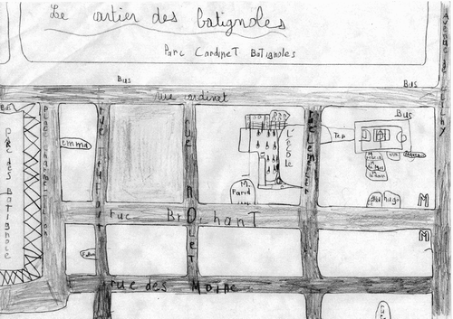
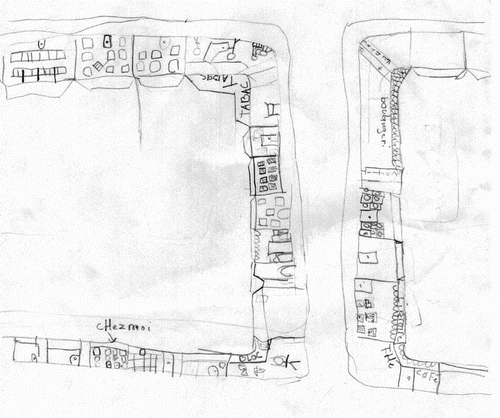
Amongst the children of our sample, Marc is one of the only ones to have chosen to represent the neighbourhood in the form of a ‘plan’ (), and it is undeniably in this representation that the scale, the exactitude and the precision is the most advanced. The space represented covers 11 blocks; it is named (it is for him ‘the Batignolles neighbourhood’), as is each of the streets within it. The important places in his day-to-day life are precisely located: the two parks, the school (including a plan of the playground, admittedly on an excessive scale compared to the reality), the sports field (also with a plan of the field), as well as the location of his home (‘me’) and that of his classmates' homes. During the discussion, he justifies his choice of representation: ‘I thought to myself it's good to do a map like that, I know it's to know a bit more of the neighbourhood, so we know, for example we can say there's the street, like what's happening and stuff’. He therefore sees in the plan the most appropriate means to sum up (and transmit) his knowledge of the neighbourhood. His representation of the neighbourhood points to a very astute understanding of the organisation of the space.
Figure 1. Marc's neighbourhood.
At the other end of the scale, LilianFootnote4 () chose to represent his neighbourhood in the form of a ‘pictorial map’. This creates an aesthetically pleasing composition: every element (the buildings, a street, a park, people) is meticulously coloured in crayon and harmoniously laid out on the page. However, the graphic design is relatively simplistic, hardly seeking to reflect the complexity of the reality, and, above all, the relative geographic positioning is incoherent. The discussion with Lilian confirms his total lack of sense of space: he struggles to recognise the places presented to him in the photos, and hardly names any of them. What is more, on several occasions he refers to his neighbourhood as Paris.
Figure 2. Lilian's neighbourhood.
Prima facie, these two cases seem to confirm a progressive conception of the type of representation adopted by each child to portray its environment: the drawing is characteristic of cognitive abilities still in their infancy, whereas the map points to a more sophisticated conception of space and would be associated with a later phase of intellectual development. And yet several elements suggest that this interpretation be qualified. Firstly, it should not be forgotten that both children are the same age: 10 at the time of the discussion. Secondly, we would expect the academic performance of the children to reflect their spatial awareness: on the contrary, the teacher reveals that Marc is an average student, and Lilian is more successful in school.
Whereas Marc's parents are biologists and chemists, Lilian's have modest jobs in the building and caretaking trades, respectively. Can the children's social background explain the differences in their spatial awareness? A hypothesis could be presented whereby middle class children are culturally more exposed to cartographic representations than those of the working class. But this is difficult to determine with certainty from our sample, which is quantitatively limited and offers contradictory examples. Let us note also that girls and boys chose one or other of the modes of representation in equal numbers. Finally, the choice of the ‘plan’ over the ‘pictorial map’ is perhaps less a question of cognitive maturity or individual or social competence. The drawing, more than the plan, and beyond the question of spatial organisation, enables the landscape dimension of the area to be highlighted.
Representing landscapes… inhabited landscapes
In their entirety, the drawings are in fact a more appropriate form than the maps to appreciate the perception of the urban landscapes.
The urban environment, from the barren to the fertile
Firstly there emerges from the children's drawings a clear impression of density: often the environment is represented as five- or six-storey buildings, attached and relatively narrow, with almost inexistent pavements. This is how almost all of the nine children who live close to the avenue de Clichy (or who use it to go to school), as well as a few other children who live strictly within the Batignolles neighbourhood, chose to represent their neighbourhood (six in total). Sophie's drawing illustrates it well (): for her, the neighbourhood consists visually of a succession of buildings lined up along the avenue de Clichy. And by drawing a long segment on two levels she accentuates the feeling of density, as the majority of the page is taken up with buildings. Sometimes the height of buildings is exaggerated compared to the reality, reminding us that the small size of the children accentuates for them the effect of verticality. Conversely, it can be that only the ground floors are represented, which may also be linked to the children's specific field of vision, limited vertically by their height and horizontally by the buildings on one side and the continuous line of parked cars along the pavement on the other.
Figure 3. Sophie's neighbourhood: a dense neighbourhood.
Beyond the density, the children rarely sought to represent the specificities of the Parisian architecture. They certainly drew apartment buildings rather than detached houses, but the buildings are often represented through the classic symbols used by children to portray houses: a large square for the main part of the building, a triangle for a roof, smaller squares as windows, as well as a rectangle to signify the front door. Olivia is the only one to have paid attention to the architectural details of the façade of her building, notably drawing blue double doors, rounded at the top, as well as several wrought iron balconies (). It just so happens that her mother is an architect: we can assume that she raised her daughter's awareness to the urban landscape, which the majority of the other children do not clearly identify.
Figure 4. Olivia's neighbourhood: landscape and architecture.
If Sophie and Olivia's drawings give an entirely barren image of the neighbourhood, others leave a place for nature also. The local park, which nine children chose to represent, appear to be the archetypal places of nature within the city. Thus Victoria, who had come from one of France's overseas territories at the start of the academic year, dedicates no less than a quarter of the page of her pictorial plan to the Martin Luther King Park: the rest of the neighbourhood is merely sketched in pencil, whereas the visual importance of the park is accentuated by meticulous colouring with a felt-tip pen, where the green (trees, more plentiful than in reality) and the blue (of the small stream, oversized in the drawing) are predominant. The discussion confirms her sensitivity to nature, which in her case involves a rejection of the neighbourhood, of Paris, which she blames for being ‘polluted’, and a painful nostalgia for her original home: the park seems to be one of the only places where ‘she feels better’. However, sensitivity to nature does not always reflect a rejection of the city. For many children, the park is an important vehicle for their attachment to the neighbourhood: some (mainly girls, as well as a few boys) give it pride of place in their drawings. Others only reflect on it, but at length, during the discussion. They mention the park for its natural qualities (mainly the girls), others for its playful qualities (mainly the boys).
A lively area
The neighbourhood is not for these children a lifeless area, be it barren or fertile. The drawings manifest particular attention to the uses of the area, aside from the park. This is the case in Olivier's pictorial plan, where shops act equally as spatial landmarks within the represented area, identified by their function (‘tobacconist's’, ‘bakery’) or by their name (the ‘Bloc’ restaurant) (). Often the children do not merely settle for showing the location of the shops but also draw their interiors. Olivier notably sketches the clients in the tobacconist's, leaning on the counter or sitting at a table, as well as the waiter. This sensitivity towards the shopping activities of the neighbourhood, which shows in 13 drawings, also emerges in a number of the discussions. Whether or not they like shopping, 11 children appreciate the presence of shops within the neighbourhood. Kamel, who is used to doing a certain amount of shopping alone, sees them as practical due to their proximity (‘We don't need to go very far’). Beyond the simply functional aspect of the shops, some children evoke their emotional link to the products sold in these shops, such as Antonia, of Portuguese origin, who speaks with enthusiasm of the market, where she can find Portuguese products.
Figure 5. Olivier's neighbourhood: a shopping district.
The school appears on Olivier's drawing, as it does on that of 11 of his classmates (who have no specific features in terms of gender, social background, and the location of their home in the neighbourhood). This is inevitably linked in part to the fact that the drawings were done within its four walls; but it also demonstrates the unquestionable importance of this place in their everyday life. Gaelle thereby draws the school disproportionately, making it occupy the entirety of the block of houses – it only really covers an eighth of it – whereas Mathieu and Marc carefully map the playground. This logically results from the fact that the school takes up a large part of their daily time. It has therefore become the hub of their social relationships. Asked about their friends, the children make a clear distinction between ‘school friends’ (which turn out most of the time to be classmates) and friends from elsewhere, (those from ‘the building’, ‘the park’, ‘dance class’, or ‘handball’). They clearly categorise them according to the place and activity (and therefore the frequency of their meetings) which lead them to meet, and give their classmates almost systematically the emotional priority. These friendships are maintained essentially during school hours and extracurricular activities, but they sometimes extend to other places: the park (for spontaneous meetings), the household (for personal invitations), or birthday parties. In short, the drawings and discussions highlight the fundamental role played by the school in the children's neighbourhood.
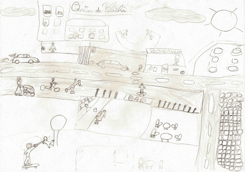
The landscapes and places represented are often inhabited: 15 drawings include at least one person, be it a simple representation or a more elaborate one. In his pictorial plan, Salih () shows 13 people going about their varied businesses: a mother pushes the pram of her child, shopkeepers serve their clients, and children walk their dog, play with a ball or skateboard. On the street he draws a driver, a cyclist, and some young people rollerblading. He demonstrates well how different places of the neighbourhood (shops, parks, the school) give rise to intense pedestrian activity, even if he particularly insists on the playful nature of the space. The discussions confirm that the neighbourhood, for these children, truly is a place of social interactions. Several of them explain that they appreciate it because they ‘often meet friends’, or even family. Most of the time, however, children encounter strangers: these ‘people of the neighbourhood’ are judged as ‘sometimes nice’, and ‘sometimes not very nice’, or ‘not very kind’. One girl tells in particular of a ‘fight’ that happened between children in the park: the episode developed within her a feeling of worry but without affecting her frequenting the area, where she still likes to go with her older sister and her friends. These tensions are also mentioned by Marc: his mother does not allow him to go to the park alone due to the presence of teenagers she describes as ‘scum’: ‘there's a football pitch and I play there and sometimes there are bigger boys who kick us out’. The Martin Luther King Park, situated on the border of the Batignolles and more working-class Epinettes neighbourhoods, is a space which often reveals tensions linked to age groups and social backgrounds (Karsten Citation1998). Despite a few counter-examples, on the whole the children are serene about their cohabitation with the locals and other users of the neighbourhood, be they familiar or strangers.
Figure 6. Salih's neighbourhood: a lively area.
An embodied perspective
Through their drawings, the children have portrayed a more or less aesthetic image of their neighbourhood. The discussions confirm that the visual sensitivity – which is the basis for their aesthetic judgment in some cases – and more largely the embodied approach, is an integral part of their relationship with the neighbourhood. Gaelle explains, for example, that she likes her neighbourhood because she finds it ‘pretty’, before adding: ‘well, there are some things which are pretty, but it's not that nice’. Certain places attract the attention of the children in particular: the park, the library, the market (‘there are loads of lights, and it's nice, and it makes you want to eat’). Léa admits that she's very attached to the view she has from her apartment, especially ‘when the weather's good’. Some children assimilate their aesthetic appreciation of the neighbourhood with the whole city: ‘Paris is pretty’, Antonia considers, whereas Martin calls on his experience of other urban areas (he knows the south of France for having spent his holidays there; he has also been to Eastern Europe for family reasons): ‘I love this neighbourhood and I love Paris too. (…) It's the nicest city I've seen so far’.
Of course, the graphic method emphasises the visual dimension. But orally, the children also explained the way in which their other senses allow them to comprehend their neighbourhood. Several of them therefore brought up the sound dimension: in general, the neighbourhood is known for its ‘calm’, a term whose connotations are clearly always positive. But Samantha clearly distinguishes between different areas of the neighbourhood according to the noise intensity: she compares the ‘calm’ areas (the library, rue Brochant), which she appreciates, she who dreams of living in the countryside, with the ‘noisy’ places (the park, place Clichy, the market). Olivia, for her part, mentions the noise variations of certain places over time: she appreciates the park when it is calm, but dislikes it when there is ‘lots of noise’ and ‘lots of people’. In other words, the notion of calm is ambiguous: it refers also to a need for tranquillity, for separation from the density of the urban bustle. Finally, other children mention their sensitivity to odours. Lilian, trying to describe what he dislikes about the neighbourhood, ends with: ‘for example, when it smells on the ground’. In short, the children have an undeniably sensitive approach to the space: ‘a large part of their knowledge of the neighbourhood is physical and is thus embedded in their bodies. (…) The children are present in the neighbourhood and they have the neighbourhood “under their skin”‘ (Rasmussen and Smidt 2003, p. 97).
In predominantly choosing the drawing over the map, it may be that the children showed that the neighbourhood is for them a space that is more perceived than conceived, and it would be remiss to interpret the small number of maps as merely pointing to a lack of cartographic skills. In this perspective, the drawing is a more appropriate tool than the map to account for their physical relationship with their neighbourhood.
Territories of different scales
The examination of the graphic productions helps us appreciate the variations in the expanses of the represented spaces. These variations are due in part to the choice of mode of representation: the drawing favours the large scale, and the plan (pictorial or not) the smaller scale. But this is not always the case and other factors account for the varying scope of the territories in the children's everyday lives.
From the home…
The great majority of the children's graphic productions is linked to the home; it either appears directly in 15 drawings or a perspective is presented as seen from the home in 3 more drawings. Unsurprisingly, the home appears as a stronghold of the neighbourhood, qualified by Golledge as a ‘primary node’ or an ‘anchor point’ (1985 cited Aitken Citation1994, p. 61). Three children assimilated the representation of their neighbourhood with that of their building, either by restricting themselves to its façade, or by enlarging its perception from neighbouring buildings.
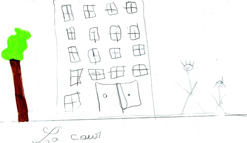
Thereby Shelihane's very rough drawing () (she uses symbolism which one would expect from a younger child), represents her building, with a tree and two people. It suggests that for her the neighbourhood can be reduced to the exterior façade of her building: it is constituted by what she sees of her ‘house’ when she is ‘outside’. And indeed the child, who clearly struggles to express herself in the presence of the interviewer, leads us to presume a certain weakness in her practices in the neighbourhood. Of North African origin, she lives alone with her mother, who works as a cleaner, in a household which she qualifies as ‘too small’ a studio. She struggles to identify the places presented by the photos, and it emerges that she scarcely frequents places in the neighbourhood other than the school and sometimes the library, accompanied by her mother without fail. Most of the time, due to the cramped nature of her home, she plays in the courtyard of her building – which is the title she gives to her drawing – with her neighbour or her cousins. For her, therefore, the neighbourhood is firmly anchored around the home. Shelihane's drawing and discussion, despite an apparent lack of quality, reveal a relationship with the neighbourhood in itself very limited and based around the home.
Figure 7. Shelihane's neighbourhood: the courtyard of her building.
…to the neighbourhood
The (pictorial) plan form often allowed the other children to represent larger spaces (up to 11 blocks for Marc) than those who chose to do a drawing or pictorial map. We had expected that the graphic productions would give some indication of the expanse of the children's territory. But it turned out that all of them actually demonstrate a glaring discrepancy with the discussions on this point, the latter leading to presume spatial practices far more spread out than in the drawings. In addition, much more conclusively than the drawings, the interviews illustrated the contrasting scales of the children's territory, by highlighting the differing intensity of uses, the variety of the types of uses, and the diverse level of parental supervision that the children experience in the Batignolles neighbourhood.Footnote5 The question therefore arises of the factors that might explain theses variations in territory.
The research has put forward several elements to explain this differentiation. Firstly, it has been established that the girls have less spatial freedom, and, accordingly, less knowledge of the neighbourhood, than the boys: the scope of the ‘home range’ is directly linked to the educational principles of the parents: they require that the girls be more involved in household tasks, which limits their leisure time and space; what is more, considering them to be more vulnerable to sexual abuse, the parents do not allow them to wander as far as the boys (Ward Citation1978, Hart Citation1979, Matthews Citation1987). More recent studies however tended to show that this trend may be changing in part because the parents' representations are becoming more complex (Valentine Citation2004). While the drawings in our study do not allow to differentiate the expanse of territory of boys and girls, the interviews do confirm that the girls have a territory somewhat more restricted than boys, that their uses of the neighbourhood are less varied and more strictly supervised by adults.
Irrespective of gender, other researchers have shown that working class children benefit from a greater freedom within the neighbourhood, whereas middle class children live instead in an urban environment made up of disconnected places, and are constantly being ferried from one to the other by their parents (Larreau Citation2003, Zeiher Citation2003). It is true that, in this class, several children from the more modest families are free to roam the neighbourhood with a greater degree of autonomy, as the interviews reveal it: they go to the park without their parents to meet with friends, are regularly sent to do small shopping errands, and have been getting to school on their own for some time. This independence is relative, however, as, according to the teacher, none of them ‘hangs out’ in the neighbourhood: they only spend a small portion of their out-of-school time there. But this social interpretation of the freedom of children in the public urban space is more subtle: on the one hand, other children of parents from lower income families admit to far more limited practices – in intensity and autonomy – and to a very rough knowledge of the neighbourhood; on the other hand, a few middle class children enjoy considerable spatial autonomy.
The greater freedom within the neighbourhood enjoyed by these working-class children appears to go hand in hand with less involvement in out-of-school activities: only 6 out of 16 working class children have such activities. Lilian, son of a caretaker and a worksite foreman, when asked about his activities away from the classroom, answered revealingly: ‘well I run a lot, I play a lot of football, and I go to the country a lot’. He doesn't, therefore, spontaneously associate the notion of ‘activities’ with those that are organised and supervised by adults. Middle class children, for their part, are undoubtedly involved in more sporting and cultural activities within or outside their neighbourhood (9 out of 11 children). But, unlike what has been shown in other contexts, this does not weaken their link to the neighbourhood, and they all demonstrate a clear fondness and a great knowledge of it: they recognise most of the areas shown in the photos, spontaneously naming and positioning them in the space, and giving the street name. On the contrary, we can infer that their multiple activities help to anchor and broaden their territory, as most of these activities happen in the neighbourhood or in close proximity, and because they often go on foot, even if accompanied. Let us note also that the middle classes do not have a monopoly over extra-curricular activities: several children from the more modest families also take part in sporting activities. The ‘Ateliers Bleus’ and leisure centres, sporting and educational activities financed by the City Council and often based at the school, only account for part of these children's activities. For them as for their middle class classmates, the mobility involved in these activities deepens their relationship with the neighbourhood.
The children in our study have therefore built very contrasting local territories. Admittedly the size of our sample does not allow us to make clear-cut conclusions or to establish a social categorisation of the relationship the children have with their neighbourhood. If the analysis reveals contrasted spaces, which partly result from class and gender differences, the causal link is far from being systematic. In fact, we can put forward a hypothesis whereby the socio-cultural diversity of the neighbourhood, the school, and the class in question, strongly contribute to blurring the dividing lines classically established according to sex, social background or the children's culture.
Alissa provides a perfect example. Her drawing, which represents her building and the neighbouring buildings in the street, may lead one to believe initially that her day-to-day life revolved around her home. Not at all. Alissa, who is 10, lives with her older brother and her mother, a French woman who looks after children for a living, the father having returned to live in his country of origin in North Africa. She enjoys great freedom in the neighbourhood: she goes to school alone and she likes to meet up with her friend in the park or at the library. Alissa appreciates this freedom, organised around sporting activities she really enjoys. This strong sense of independence, undoubtedly encouraged by her father's absence, upsets the classic girl/boy divide in the usage of the neighbourhood, with external and autonomous practices one might expect from boys. She frequents and knows her close neighbourhood as well as a wider territory, right up to the close suburbs – where her activities take place (figure skating, horse riding) – that she often reaches alone, by public transport. Her activities associate her more with middle class children, but, unlike them, she navigates this vast territory alone for the most part.
Two houses: which neighbourhood?
If the home is the fundamental centre of the child's neighbourhood, what happens when, for family reasons, the child alternates between two houses? In this class, the majority of the children lives in one household, either because their parents live together (14 children), or because they live there with their mother and do not (or rarely) see their father any more (seven children, mostly from working class families). But five children (all from middle class backgrounds) have separated parents who continue to be involved in their everyday lives: they alternate, therefore, at varying rhythms, between the father's and the mother's house. This special residential situation, relatively common in today's society, is not without effect on these children's relationship with their neighbourhood.
The first question facing these children at the time of the drawing was that of the choice of home and/or neighbourhood to represent. Mathias thereby drew the home of his father, who lives in nearby Epinettes neighbourhood, even though his mother lives closer to the school and within the neighbourhood of the study: ‘I couldn't do both, I had to choose. I chose my dad's’. It did not occur to him to represent his neighbourhood on a more reduced scale which would have allowed him to include both homes: his drawing features only his father's house and its ‘little garden’, more insistent on the exceptional nature of this kind of home in a dense urban environment than its place within the neighbourhood. He does, however, explain that both his houses count for him as part of his neighbourhood. And the teacher explains that she often sees him travelling between the two homes of his parents: he therefore enjoys a certain level of spatial autonomy earlier than some of his classmates. The fact that he has two homes, close but distinct, by adding a ‘primary node’ around which the child's territory revolves, results in an enlargement of his daily space.
This enlargement is even clearer in Olivier's case. One of his parents lives in the Batignolles, the other in the wider suburbs. When the two parental homes are too far apart, the child must choose one of them for his drawing. The choice of his mother's home, where he lives during the week, comes naturally to him: ‘It's (my neighbourhood) more here because (…) I'm only there every other weekend and I live here and school's here and (…) all my friends are here’. In other words, the neighbourhood is for him the territory encompassing not only the home, but also the school and his friends. Unlike Mathias, he does not demonstrate independence when travelling within the neighbourhood, and shows no great desire to do so: he goes to school alone but prefers it when his sister takes him. Away from his organised activities, he frequents few places in the neighbourhood, his practices seemingly based around his homes. On the other hand, due to his alternation between parental homes, he has a clear conception of the scale of his territory, from the Batignolles neighbourhood, to Paris, to the wider suburbs. For him the scales are associated with different practices (school and extra-curricular activities, leisure outings in Paris and visits to his father), different means of travelling (on foot, by bus, by metro, or by car) and different timeframes (the week, the weekend). Children of separated parents thereby shape an enlarged, or even multi-scalar, daily territory.
Conclusion
Putting the drawings of the neighbourhood in perspective with the discussions conducted with the children reveals the richness of the graphic method for analysing their relationship with their neighbourhood. Unquestionably, these drawings, which are the result of a complex filtering process (as repeated research has shown in recent decades), are heterogeneous, even though they were produced by children of the same age living in the same urban environment. Some are ‘detailed’, that is to say dense and meticulous, whereas others are ‘sketchy’ and offer few elements which enable the relationship with the neighbourhood to be characterised; some are plans, others are pictorial maps, and others even belong to an intermediary category (pictorial plans). This diversity, which can initially seem disconcerting, is worth being interpreted in the light of outside information. Certain ‘sketchy’ drawings thereby appear to represent a true account of the relationship with the neighbourhood for certain children. In addition, the choice of form of representation is not insignificant and must not be seen as a reflection of the level of spatial awareness: on the contrary, it can be that it signifies different projects and contrasting relationships with the neighbourhood. The plan, for example, facilitates a clearer expression of the knowledge and mastery of the organisation of the space for a certain child, the neighbourhood for him being conceived above all as a body of places and spatially structured elements. The drawing, in contrast, is more adapted to those children for whom it is the best means of representing the landscape and the atmosphere: for them, the neighbourhood is above all to be lived and felt.
This diversity in forms of graphic production is in part a reflection of the diversity in the relationships between the children of the Batignolles CM1 class (Year 5) and the neighbourhood. Where some might insist on the properly urban dimensions of the neighbourhood (density, architectural characteristics), others concentrate on the natural elements (parks, vegetation, and animals). Several children associate the notion of neighbourhood not with the landscapes but with the activities and people who liven it up on a daily basis. But the drawings do not demonstrate the variable scope of the neighbourhood according to the children. Only the interviews allow to assess the contrasting expanse of their territory, from the apartment building to an area of several blocks. These differentiations can sometimes be explained along the lines of class, gender, family situation, or the children's personal history. However, our study reveals that, in this socially diverse gentrified neighbourhood, these traditional lines are sometimes blurred.
It remains to highlight certain common points emanating from the discussions in the experiences that these children have in their neighbourhood, which are not always highlighted in the drawings: on the whole, the neighbourhood is for them a territory based primarily around the home, the school, and the park. They are deeply fond of them and their fondness rests upon a functional, social and physical judgement. In other words, the neighbourhood is made up of what they see, of what they do, what they feel, and the people they meet. And it is this combination of different methods, visual and oral, which enables us to comprehend the complexity of the child's relationship with the urban space.
Notes
It must be pointed out, in addition, that the research studied the families from a local private school in order to gauge the extent of possible avoidance of the state school system by certain families, and the variations this may lead to in their practices and their representations of the neighbourhood.
‘Quartier’ is a term commonly used in France, but it does not carry any single definition. It refers to a concept differentially appropriated by a variety of disciplines within the social sciences; it also refers to a category constructed and used by politics for socio-spatial action; it finally refers to the everyday experiences and representations of the people who live in it and use it (Authier et al. Citation2006). In other words, the institutionalised neighbourhood and the experienced neighbourhood do not strictly overlap.
All the names have been changed for anonymity purposes.
Lilian, with no ‘e’ at the end, is a boy's name in French.
We are in the process of developing these aspects in greater detail in a forthcoming paper.
Related Research Data
References
- Aitken , S. 1994 . Putting children in their place , Washington , DC : Association of American Geographers .
- Authier , J.-Y. , Bacqué , M.-H. and Guérin-Pace , F., eds. 2006 . Le quartier: Enjeux scientifiques, actions politiques et pratiques sociales , Paris : La Découverte .
- Beaud , S. 2002 . 80% au bac… et après ? Les enfants de la démocratisation scolaire , Paris : La Découverte .
- Béneker , T. 2010 . Picturing the city: young people's representations of urban environments . Children's Geographies , 2 ( 8 ) : 123 – 140 .
- Bernard , L. 2004 . Le XVIIème arrondissement de Paris: des cicatrices profondes, une mixité introuvable Unpublished thesis. University René Descartes-Paris V
- Bidou , C. 2003 . Retours en ville , Paris : Descartes .
- Blaut , J. and Stea , D. 1971 . Studies of geographical learning . Annals of the Association of American Geographers , 61 : 387 – 393 .
- Chawla , L. 2002 . Growing up in an urbanizing world , Edited by: Chawla , L. London : UNESCO Publishing/Earthscan .
- Chombart de Lauwe , M.-J. 1977 . Dans la ville des enfants , Edited by: Chombart de Lauwe , M.-J. Paris : Autrement .
- Christensen , P. and O'Brien , M. 2003 . Children in the city: home, neighborhood and community , Edited by: Christensen , P. and O'Brien , M. London : Routledge .
- Danic , I. , David , O. and Depeau , S. 2010 . Enfants et jeunes dans les espaces du quotidien , Edited by: Danic , I. , David , O. and Depeau , S. Rennes , , France : Presses Universitaires de Rennes .
- Depeau , S. 2008 . Radioscopie des territoires de la mobilité des enfants en milieu urbain: Comparaison entre Paris intra-muros et banlieue parisienne . Enfances, Familles, générations , 8
- Desena , J. 2009 . Gentrification and inequality in Brooklyn: the new kids on the block , Lanham , , MD : Lexington Books .
- Enaux , C. and Legendre , A. 2010 . “ Méthode d'identification des lieux investis par des enfants de six à onze ans dans leur espace de vie urbain quotidien ” . In Enfants et jeunes dans les espaces du quotidien , Edited by: Danic , I. , David , O. and Depeau , S. Rennes , , France : Presses Universitaires de Rennes .
- Glass , R. 1964 . “ Introduction: aspects of change ” . In Center for Urban Studies, ed., London: Aspects of Change. London: McKibbon and Kee
- Gould , P. and White , R. 1974 . Mental maps , Harmondsworth , , UK : Penguin Books .
- Hart , R. 1979 . Children's experience of place , New York : Irvington .
- Holloway , S. and Valentine , J. 2000 . Children Geographies: playing, living, learning , London & New York : Routledge .
- Karsten , L. 1998 . Growing up in Amsterdam: differentiation and segregation in children's daily lives . Urban Studies , 35 ( 3 ) : 565 – 581 .
- Karsten , L. 2003 . Family gentrifyers: challenging the city as a place simultaneously to build a career and to raise children . Urban Studies , 40 ( 12 ) : 2573 – 2584 .
- Karsten , L. 2007 . Housing as a way of life: towards an understanding of middle-class families' preferences for an urban residential location . Housing Studies , 22 ( 1 ) : 83 – 98 .
- Kokoreff , M. 2003 . La Force des quartiers. De la délinquance à l'engagement politique , Paris : Payot .
- Larreau , A. 2003 . Unequal childhoods: class, race, and family life , Berkeley & Los Angeles : University of California Press .
- Lees , L. , Slater , T. and Wyly , E. 2008 . Gentrification , London & New York : Routledge .
- Legendre , A. 2010 . “ Evolution de la connaissance et de l'utilisation des espaces publics extérieurs entre 6 et 11 ans. Le cas d'Arpajon, une petite ville de la banlieue parisienne ” . In Enfants et jeunes dans les espaces du quotidien , Edited by: Danic , I. , David , O. and Depeau , S. Rennes , , France : Presses Universitaires de Rennes .
- Lepoutre , D. 2001 . Cœur de banlieue , Paris : O. Jacob .
- Lynch , K. 1960 . The image of the city , Cambridge , MA : MIT Press .
- Lynch , K. 1977 . Growing up in cities , Cambridge , MA : MIT Press .
- Matthews , H. 1984 . Cognitive maps of young children: a comparison of graphic and iconic techniques . Area , 16 : 31 – 41 .
- Matthews , H. 1985 . Young children's representation of the environment: a comparison of techniques . Journal of Environmental Psychology , 5 : 262 – 278 .
- Matthews , H. 1987 . Gender, home range and environmental cognition . Transactions of the Institute of British Geographers , 12 : 43 – 56 .
- Matthews , H. 1992 . Making sense of place: children's understandings of large-scale environment , Hemel Hempstead , , UK : Harvester Wheatsheaf .
- McKendrick , J. 1999 . The geography of children: an annoted bibliography . Childhood , 7 ( 3 ) : 359 – 387 .
- Piaget, J. and Inhelder, B., 1947. La représentation de l'espace chez l'enfant. Paris: PUF.
- Ramadier , T. and Moser , G. 1998 . Social legibility, the cognitive map and urban behaviour . Journal of Environmental Psychology , 18 : 307 – 319 .
- Valentine , G. 2004 . Public space and the culture of childhood , Burlington , , UK : Ashgate .
- Ward , C. 1978 . The child in the city , London : Architectural Press .
- Young , L. and Barrett , H. 2001 . Adapting visual methods: action research with Kampala street children . Area , 33 ( 2 ) : 141 – 152 .
- Zeiher , H. 2003 . “ Shaping daily life in urban environments ” . In Children in the city: home, neighborhood and community , Edited by: Christensen , P. and O'Brien , M. 66 – 81 . London & New York : Routledge .
- Translated from the French by George McGairl.