Abstract
The new demarcation of land in Kosi Bay, aimed at reversing the spatial legacy of apartheid, has resulted in competition and new environmental conflicts between political structures, conservation authorities and local communities. The current complex governance framework is attempting to overcome the problems created by the political structures of the apartheid era, during which time the declaration of natural areas for conservation resulted in forced removals and negative perceptions of conservation. The case study of Kosi Bay, a strategic area for tourism development, is a typical example of various confrontations that reflect the history of the past and the rivalries of the present.
1. Introduction
1.1 Research position on environmental conflicts
The environment can be seen as a space altered by humans, whose natural components (fauna, flora, morphology, etc.) and social components (residents, housing, etc.), in dynamic interaction, are often destabilised. The environment can be endangered by a human action (such as a polluting industry, or clearing a forest) or a physical action (a ‘natural’ catastrophe): one speaks, thus, of ‘environmental problems’. This dynamic definition of the environment implies that the researcher must take a position on the genuine seriousness and long-term implications of the destabilisation that has been caused. The author has chosen–in this research, in this very particular South African context–a ‘social’ position on the environment. Improving the individual's health and his or her social wellbeing (reduction in poverty) takes priority over the strict preservation of ‘nature’ (Biehl & Staudenmaier, Citation1995; Thompson, Citation2002; Guyot, Citation2003). Social progress and environmental sustainability can be associated under certain conditions, but these conditions are rarely united (Eden, Citation2000; Bond, Citation2002).
Diverse groups of stakeholders, more or less well organised in shifting coalitions, position themselves differently on very precise and spatially localised environmental questions. The above definition of the environment thus implies that there will be confrontations between stakeholders over the use of space. Because the environment is a spatial dynamic, and conflicts between stakeholders cover processes that are not spatially defined (stakeholders, coalitions of stakeholders, logic and strategies), the concept of environmental conflict can be validated as a methodological tool for the joint study of space and stakeholders (for South Africa, see Bond, Citation2002; Clarke, Citation2002; Dovers et al., Citation2002; Guyot, Citation2003; for the rest of the world, see Dahl, Citation1993; Wong, Citation1993; Collinson, Citation1996; Eden, Citation2000; Dietz, Citation2001). In the field, it allows a process for compelling stakeholders to take a stand both on problematic environmental questions and in relation to other stakeholders.
Environmental conflict thus helps to bring to the fore representations, strategies and practices, as well as coalitions linked to the stated problem. Environmental conflicts are both methodological and conceptual tools, as used by Moore Citation(1998) and Crowfoot & Wondolleck Citation(1990) in their research.
1.2 Environmental conflicts at Kosi Bay
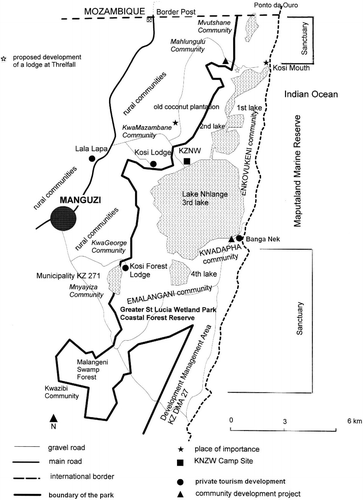
Geographically, Kosi Bay (see ), on the north-eastern coast of South Africa, includes the whole area between the Indian Ocean, the grasslands on the western and southern parts of the four lakes system and the Mozambican border in the north. Although it is a tribal land in the custody of the Tembe Tribal Authority, the major part of this land was proclaimed a nature reserve in the late 1980s by the provincial administration. From a human point of view, the Kosi Bay area comprises many different scattered communities. Some of them are part of the nature reserve (Emalangeni, KwaDapha, Enkovukeni), while some others are excluded from it (KwaZibi, KwaMazambane, KwaGeorge). Manguzi is the only small town next to the Kosi Bay area and it plays an important role as an administrative and commercial centre. Despite the difficulty of differentiating between urban, peri-urban and rural in these areas, Manguzi's urban population is estimated to be 10,000 and the population of the rural areas between the city and the Park around 20,000. The new municipality brings together 141,000 inhabitants (Municipal Demarcation Board, Citation2003).
Figure 1: The Kosi Bay area
In Kosi Bay, environmental conflicts oppose community-based extraction and nature conservation in the arena of competing tourism development. These conflicts are now occurring in a post-apartheid era characterised by a new and complex governance context.
1.3 The problem: political dimensions of environmental conflicts at Kosi Bay
Ten years ago, apartheid was abolished. The Kosi Bay area, formerly coveted by Afrikaners seeking access to the ocean and faced with the British hold on the area, is now exploited by the African National Congress (ANC) in order to reinforce its territorial power over the rural lands favouring the Inkatha Freedom Party (IFP).Footnote1 However, the influence of whites remains a reality in a spatial framework that is still very inert. It remains to be seen who will win in this dispute over the Kosi Bay coastal environment.
The Kosi Bay area is characterised by an environmental logic that makes preserving the environment a means to reserve the enjoyment of the area for a few wealthy individuals. Since the end of apartheid, new political strategies have accompanied this logic. Tourist development has come to the aid of the strictly environmentalist logic to try to create jobs and thus redistribute profits to the historically disadvantaged black populations.
The Kosi Bay area crystallises conflicting uses of the coastal environment, systems of stakeholders opposing each other and a territorialisation shared between regulatory ambition and post-apartheid geopolitical appropriation. The ANC government tries to reinforce its territorial power while simultaneously disengaging financially. The neo-liberal policy change of the new South Africa in 1996, with the adoption of the Growth, Employment and Redistribution Programme (GEAR)–thus putting to rest the ANC's initial socialist aspirations during the Reconstruction and Development Programme era (RDP, 1994–6)–also marks the renewal of South Africa's use of the environment as an economic asset (promoting and investing in natural parks, ecotourism). However, it is not a mistake that the ‘Rio + 10’ Summit was held in Johannesburg in September 2002. The South African government–the ‘good pupil’ of the international organisations–must agree to a policy of continued wise use of resources in all their forms, and the environmental issue is now at the heart of the international community's preoccupations.
1.4 Methodology
The methodology of this study is based on that developed by the French anthropologist Olivier de Sardan Citation(1998). A qualitative approach was used, based on interviews with representative and significant stakeholders and on meeting observations. Because some interviewees preferred to stay anonymous, this paper refers to them only by their positions. The interviews took place with the help of a local interpreter for the Zulu-speaking stakeholders between December 2000 and November 2004.
Three levels of stakeholders are involved in spatial competition: national, provincial and municipal (or local). While the local level is dealt with as a priority in the discussion because this is a case study based on one community, relationships between and potential conflicts with the other two levels of stakeholders are also central to this paper. At this stage it is important to define these stakeholders, who fall mainly into two categories. First are the decision-making actors (political, technical and economic for each sector) and, second are the regulating actors (for example, associations, citizens). Classifying traditional leaders in this twofold division proved problematic, so they have been put into a further category of stakeholders with their own strategies and dynamics.
A question that might be asked is why there is a gap between the discourse of stakeholders and what they put into practice (that is, between the stakeholders' logic and the logic of their choices). The difference between words and practice also has to do with the relationships between technical decision-making power and the elected political power. The technical decision-making power mainly involves white South Africans in mastering skills and conserving acquired advantages. The elected political power mainly involves black South Africans in implementing the transformation.
The aim of this paper is to reflect on the various implications of the new post-apartheid governance system in the light of a legacy of major and ongoing environmental conflicts. Section 2 gives some informative data about the Kosi Bay Area; section 3 is a historical flashback to help the reader understand the gravity of the local environmental conflicts; section 4 presents the complexity of the new post-apartheid governance system; and section 5 concludes by interpreting the political significance of this new system.
2. The Kosi Bay area: Poverty versus natural assets
2.1 One of the poorest regions in South Africa
Maputaland extends from 28° to 26° south along the eastern coast of South Africa. While it is rich in natural resources, this part of KwaZulu-Natal is poor when measured by socio-economic standards. For instance, according to the Demarcation Board, 89 per cent of the population of the whole of Maputaland (Umkhanyakude District Municipality–DC 27) earns less than R18,000 (approximately US$2,850) per year compared to 43, 46 and 27 per cent for the Durban, Johannesburg and Cape Town Metropolitan Areas respectively (Guyot, Citation2002).
Kosi Bay is situated on the north-eastern coast of South Africa (see ). The entire coastline of Maputaland from the Mozambican border to the St Lucia Estuary is historically considered as confined in relation to the entire KwaZulu-Natal coast, and in opposition to the more developed southern part. Many physical constraints (for example, the subtropical humid climate and its related endemic diseases such as malaria and tick bite fever, and natural obstacles such as lakes and dunes) inhibit the development of the Kosi Bay area. Except in the swamp forest zones, the sandy soils are naturally poor and the method of cultivation that is traditionally used by farmers worsens the natural lack of nutrients (Mountain, Citation1990). Maize and peanuts are the major subsistence crops in the area. The remainder of the diet mainly comprises fish and shellfish and natural resource extraction from dune forests. A more sustainable agriculture has to remain an important activity locally to insure minimum standards of living for the populace (Bulfoni, Citation2002).
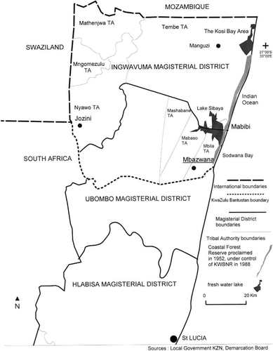
Figure 2: Maputaland, Apartheid era
The three communities inside the nature reserve are located between the Indian Ocean and the four lakes system. There are accessible only by four-wheel drive vehicle and by boat. There are residents who organise paying shuttle services with their own four-wheel drive vehicles. All government infrastructures such as hospitals, library, post office and so on are available in Manguzi. The poor system of communications contributes to the territory's isolation, apart from Manguzi, which is now well linked to the South African roads network. Water supply in Manguzi is delivered through public taps, sometimes with individual boreholes. It is essential that basic services be supplied to the people, otherwise the poverty of black rural communities, and their frustrations with nature conservation, will continue to increase.
2.2 A range of natural assets
The Kosi Bay coastal belt is, in many ways, the most attractive part of Maputaland and has great potential for tourism development. It is characterised by five different ecosystems. The coastline has sand beaches and a tidal zone rich in corals and reef life. Dune forests consist of tropical and subtropical evergreen trees growing on dunes which reach 70–120 metres in height. Grasslands are found between the freshwater lake system (which comprises a separate aquatic ecosystem rich in fish) and the dune forests. A major arboreal component of the grassland ecosystem is the Lala palm, which is used traditionally to make palm wine. Swamp forests occur adjacent to the lake system. The indigenous population has settled in the grasslands, and they cultivate vegetable gardens here and in the swamp forests. The dune forest has been used traditionally for firewood and the sea has provided marine resources, particularly fish and mussels. The recent development of tourism has meant that settlements have developed near the beaches.
Although poor in services, the Kosi Bay area is surrounded by valuable assets such as pristine subtropical dune forest containing many rare species (Govender, Citation2001) and rich coral life offshore, including more than 30 species of tropical fish in the southern Hully Point. Other permanent attractions include the scenery and a year-round warm climate with temperatures ranging from 12 to 24°C in winter to 21 to 30°C in summer. The offshore water is warm (23–26°C) owing to the effects of the Agulhas Current (Bruton, Citation1980). The combination of these assets provides a potentially tourist-friendly environment, as is evidenced by the mushrooming of tourism developments in this area today.
3. A review of local environmental conflicts
3.1 The apartheid context and the Bantustan issue: 1948–88
An the nalysis of the historical background is necessary to understand the complexity of today's environmental conflicts.
The natural assets of Kosi Bay were first taken into account in 1950 with the proclamation of the first Kosi Bay Nature Reserve by the Natal Parks Board on the western banks of Lake Nhlange for the purpose of outdoor recreation activities. At the same time the Emalangeni swamp forest was declared an Indigenous Forest Reserve by the Department of Water Affairs and Forestry. This zoning was done without taking into account the fact that the land was tribal and occupied by various communities extracting natural resources on a daily basis. However no conservation regulations were enforced before the whole area was proclaimed a nature reserve in 1989. Prior to 1972, before the creation of the KwaZulu Homeland, the provincial government administered this part of Natal from a distance. It was considered a ‘black population territory’ (see ).
The administrative affairs of the people in the Kosi Bay area were controlled by the Ingwavuma Magisterial District based in Manguzi at this time. In the 1960s governance was handed over to the Tribal Authority, especially in respect of infrastructure development. A Tribal Authority consisted of a chief (inkosi) who delegated his power, with the agreement of the people, to an induna (headman of the Tribal Authority). The latter was a person in charge of a ward–a piece of land within the boundaries of the Tribal Authority (Crouzel, Citation1999). The Tembe Tribal Authority was in charge of the whole Kosi Bay area, with the support of 49 indunas. During the apartheid era these traditional leaders were appointed by the government in Pretoria and received grants for local development (Crouzel, Citation1999).
After 1972, the area north of Sodwana Bay, which includes Mbazwana, was integrated into the KwaZulu Government Territory, an officially designated self-governing territory. The poor level of development in Maputaland is evidence that this region was not a high priority for the KwaZulu government–based in Ulundi–at this time. The reason for this was most probably the high proportion of Tonga in the area in comparison to Zulus, and its geographically peripheral location. This government managed the area with the purpose of conservation.
In the 1980s, the KwaZulu government realised that it would be beneficial in terms of self-governing autonomy to have control of its conservation areas and also to be able to proclaim new parks, as happened at Tembe Elephant Park in 1984. The control of the Kosi Bay Nature Reserve was passed from the Natal Parks Board to the KwaZulu Bureau of Natural Resources (KBNR) in 1989. This conservation agency of the KwaZulu Bantustan was essentially managed by white ‘conservative conservationists’ under IFP influence.
3.2 The environmental conflict around the proclamation of the Kosi Bay Nature Reserve: 1988–94
This environmental conflict was partly orchestrated by white stakeholders.
3.2.1 The origins of the proclamation: a possible threat to the swamp forest?
In the mid-1980s the state of the Malangeni swamp forest was a source of serious concern, but only to conservation officials. These officials were close to conservative circles within both the Zulu and the English-speaking community (Draper, Citation1998).
There was very heavy destruction of the swamp forests, and to us the swamp forests were very important to maintaining the system as it was, the clarity of the water, the nutrients, the sedimentation and silting up. We felt if we lost the swamp forests the whole area would change, the fish and the ecology. So it is of critical importance and the easiest way to protect it is to make the area a nature reserve to protect the swamp forests and the integrity of the estuarine system. So we drew a line on a map to ensure it would cover as much of the swamp forest as possible. That was the primary reason for the proclamation, to protect the swamp forests, to protect the waters of the system. (Interview with local conservation officials, Kosi Bay, 18 June 2001)
Before the proclamation a study was conducted on communities located inside the boundaries to show their different impacts on the ecosystems. Some groups of people had only a low impact on the natural environment, as in the case of Enkovukeni and KwaDapha situated between the ocean and the lakes. Other groups, however, appeared more problematic for white environmentalists, such as the KwaZibi community, who used the swamp forest for planting crops, and KwaGeorge, KwaMazambane and Mahlungulu, which were too close to the lakes and the estuary.
3.2.2 The process of relocation and compensation
The extension of the territory of the Kosi Bay Nature Reserve in 1989 implied that 158 households living inside the new boundaries had to be relocated elsewhere. These 158 families consisted of 1,200 people. The original aim of the KwaZulu Bureau of Natural Resources was not to remove these people forcibly (Natal Witness, 27 June 1989, and interview with former KBNR officials, Pietermaritzburg, 23 March 2001). Its aim was to consult the people through their intermediary, their indunas, to compensate all of them with cash for all their houses, crops and produce. Two committees were established: the Compensation Committee and the Swamp Forest Committee.
Each homestead was assessed for the type of building and the square meterage, then each banana plant was counted and the compensation rates were drawn up by the Department of Agriculture. There was a list of the homesteads and the valuation, and cheques were issued of the amount. If the person went to the magistrate and said he'd moved out, then he would get the money. That basically happened three to five years after the proclamation. The money was given directly to the people. You got a cheque in your sticky little paws. As soon as you went to the magistrate and said I've moved everything out of the reserve the magistrate gave you a personal cheque. (Interview with local conservation officials, Kosi Bay, 18 June 2001)
Nevertheless, in 1990 the KwaZulu Bureau of Natural Resources was accused by the Association for Rural Advancement (AFRA: a leftist civil society activists group close to the ANC) of forcibly removing the people without consultation and compensation (interview with AFRA officials, Pietermaritzburg, 21 January 2001). Some citizens started to resist. They did not understand why certain communities could stay (for example KwaDapha) and why others had to move out of the nature reserve (AFRA, Citation1990). It was then that frustrations within the black rural communities arose.
3.2.3 The manipulation of the process by political interests
The political context of this conflict was expressed by the ecologist of the nature reserve:
Politics got involved, IFP, ANC, the government, NGOs, there was a whole lot of political players, organisation for rural advancement. They were playing a political game, we were trying to do our responsibility. Yes: we said no to a lot of people. The politicians were trying to get votes of all parties. (Interview with local conservation officials, Kosi Bay, 18 June 2001)
To understand this conflict at the end of the apartheid era, one must analyse the role of the external non-governmental organisations (NGOs, such as the Association for Rural Advancement; CROP–the Community Research Organisation Programme, and CORD–the Centre for Community Organisation Research and Development) which decided to defend the oppressed citizens and to oppose the KwaZulu Bureau of Natural Resources and the KwaZulu homeland, which were pro-Pretoria. They started a resistance committee, Isidisi, against the removal of the population. They lobbied for a proper consultation process with the local communities and for respect for traditional agriculture. These organisations were linked with the ANC and COSATU (Congress of South African Trade Unions) and included white academics working in the anti-apartheid movement (Natal Mercury, 30 May 1990). They opposed a conservative coalition composed of whites who had long experience of conservation and were close to the KwaZulu government. This conflict was highly political, using the unhappiness of local communities as a pretext for resisting the proclamation of a nature reserve.
The chronological context of this conflict is very sensitive. The end of the apartheid was legitimating the work done by the NGOs and questioning the action of the KwaZulu government. The rural areas were at stake in KwaZulu-Natal, especially with regard to the ANC–IFP vote when the urban areas were already being disturbed by political violence (Hessel, Citation2003).
The protection of the natural environment did not improve after this event: the residents once again saw conservation as an interdiction preventing them from using their traditional land. The high level of poverty did not change with the proclamation of the nature reserve. Within the Kosi Bay area, the Banga Nek case study is a good example of what local resistance could be when boosted by external support.
3.3 A multiplication of local ‘illegal’ initiatives threatening the natural environment
Banga Nek is the tourist name of the KwaDapha location. It is situated between Lake Nhlange (the third lake of the Kosi Bay system) and the Indian Ocean. This area is populated by 300 inhabitants, originally Thonga-speaking.Footnote2 It is a traditional land managed by the Tembe Tribal Authority with the induna GN. It is also now one the best coastal spots of the Greater St Lucia Wetland Park, recognised as a World Heritage Site.
David Webster, an anthropologist from the University of the Witswatersrand, and an anti-apartheid activist, was one of the first whites interested in the development of the people of KwaDapha. He was assassinated in Johannesburg on 10 May 1989 by a member of the apartheid police. This sad event ended his research within the local community. At the same time, other academics, students and NGOs were interested in KwaDapha during the conflict surrounding the proclamation of the Kosi Bay Nature Reserve. One of them was Andrew Zaloumis (Community Research Organisation Programme), the present acting Chief Executive Officer of the Greater St Lucia Wetland Park. They helped the local people to stay within the boundaries of the proclaimed area. Influenced by these organisations and by Webster's wife, they decided to give the anthropologist's hut to the community and to start around this ‘monument’ a community camp directly managed by the locals, including the two neighbouring communities of Enkovukeni and Emalangeni.
A rivalry started between the three communities for the benefits appropriation. Some other indunas from the western side of Lake Nhlange were feeling isolated and jealous. These tensions were quite legitimate: the western communities (KwaGeorge, KwaMazambane) had been removed from the nature reserve and did not have the same tourism opportunities as the coastal communities. There were even reports of some murders between clans.Footnote3 In 1997, the KwaDapha community camp was bankrupt and had to be sold.
Now every community is trying to implement its own ecotourism project, which creates new conflicts (Guyot, Citation2004). The question now is how the new post-apartheid governance system will resolve–or worsen–these environmental conflicts.
4. The complexity of the new governance system
Since the democratic elections in 1994, the national priorities for development have been changing. The national policy of the reconstruction and development programme indicates that an equitable share of prosperity exists for all, especially in underdeveloped rural areas. But priority has been given since 1997 to neo-liberalism and private development, to attract investment in South Africa in the context of a New Partnership for African Development (NEPAD) (Bond, Citation2004). Thus, a complex and confused governance framework has been institutionalised to hide two current fundamental tasks: ANC political power in IFP territories (‘How can we control Zulu rural areas?’) and neo-liberalist development (‘How can we make money from the environment?’).
4.1 A complex governance framework recognising the natural heritage of Kosi Bay
shows the complexity of the new governance framework for the Kosi Bay area. All the various levels of power shown in this Table have some kind of management responsibility for the area, but with contrasting financial ability to drive development and different levels of legitimacy in the eyes of the community. The fact that development can only be founded on a national, ANC government-driven level, means that it is difficult for local people to initiate development. The bodies that are close to the people, at the local level, do not have the financial resources to promote real development alternatives. The political differences at the various levels, for example the ANC nationally and the IFP locally, are a deep source of rivalry and competition over resources, especially in an area with a majority of IFP voters.
Table 1: The new governance framework for the Kosi Bay area
The two main stakeholders, the residents and the tourists, who are part of the governance sphere, are not included in this table. The residents have powers through elections and popular protest, while tourists represent a (potentially) important source of financial input. The full division of powers and functions between these different levels and bodies is still evolving on the eve of the next local elections (January 2006).
In 2000, the coastline between Kosi Bay in the North and Mapelane in the South was recognised as a World Heritage Site by the United Nations Educational, Scientific and Cultural Organization (UNESCO). The protected area of Kosi Bay is located within this site. In the context of this newly acquired status, many conservationists now see an opportunity to implement a single conservation area that extends from the Mozambican border to the St Lucia estuary, as opposed to the existing fragmented pockets (i.e. Kosi Bay Nature Reserve, the Coastal Forest Nature Reserve, Sodwana Bay National Park, the Maputaland Marine Reserve, St Lucia Marine Reserve, St Lucia Game Reserve, St Lucia Park, the Mapelane Nature Reserve and the Mkuze Game Reserve). A new national authority has been proclaimed for the management of the Greater St Lucia Wetland Park. This new authority is ‘an autonomous body legally established to manage the Greater St Lucia Wetland Park and take responsibility for conserving its World Heritage Status’.Footnote4 The Greater St Lucia Wetland Park is an ‘anchor’ project of the Lubombo Spatial Development Initiative (LSDI) with KwaZulu-Natal Wildlife and the KwaZulu-Natal Tourism Authority. The close ties between the LSDI and the new authority can be seen in the fact that the LSDI manager is acting Chief Executive Officer for the new authority, Andrew Zaloumis. As a consequence, new development is included directly within the context of the park, and the priority is to create infrastructure and tourist accommodation to attract overseas visitors. The most pertinent question is: ‘Who will (really) benefit from these developments?’ (Guyot, Citation2003).
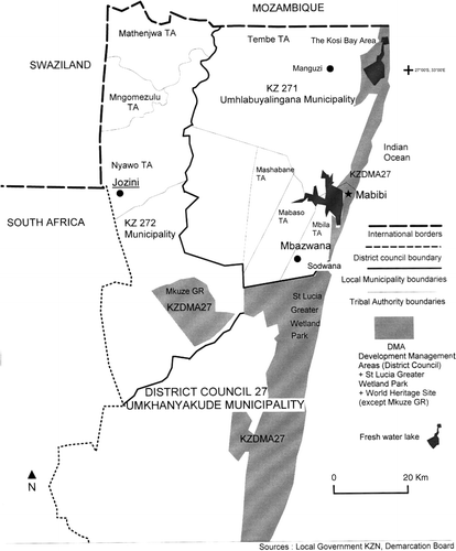
Since the second local elections in South Africa on 5 December 2000, the Municipal Demarcation Board has changed all the areas of local government so as to improve service delivery and the redistribution of prosperity. The former Regional Council was divided into two parts to create a District Council, which now represents the regional level. This new District Council consists of five municipalities at the local level, which have amalgamated rural and urban areas. A third level of local government is reserved for the less densely populated areas and the conservation areas. These are District Management Areas (DMA) and they are managed directly by the District Council. One representative is elected from each DMA as councillor on the District Council.
People who voted in DMAs had two votes for parties of their choice: (i) for the District as a whole, and (ii) for the DMA representative. The DMA representative is not for a particular area, but for all the DMA voters throughout the District municipality. Given that there is no specific person for the DMA areas (no ward councillor) in practice what should happen is that the District municipality would appoint a person from their council (who could be the DMA representative or even another councillor, as they have the right to delegate responsibilities in terms of the Municipal Structures Act.) The DMA is not a legal body, but rather the Category C (District) municipality has all the municipal powers for the DMA areas. There is no real conflict with the National Heritage Authority and I am working with them to sort out any perceived or real problems. (Interview with Mike Sutcliffe, head of the Municipal Demarcation Board, 8 April 2001)
The protected areas of Kosi Bay are now included in a DMA within DC 27. In the interviews, we noticed confusion among the local stakeholders about the boundaries of these new councils, the actual existence of the DMA, and the effective division of powers and functions. This confusion is not conducive to managing the existing conflicts (Guyot, Citation2002). Could it be a tool for extending ANC political power within a neo-liberal economy context (Guyot, Citation2003)?
Added to this is the fact that the land in question is still traditionally the property of the Tembe Tribal Authority (Ingonyama Trust). This tribal authority is now integrated in the Local Municipality, KZ 271–Umhlabuyalingana Municipality. The main consequence of these changes in political structures for the Kosi Bay area is increasing complexity. People will have to deal with this complex governance and it is pertinent to ask what the direct consequences are for development and improvements to the quality of life for the majority of the population. The following are some examples of this confusion at a local level.
4.2 A multiplication of bodies with few common aims
4.2.1 Outside the protected area
Since the end of apartheid, some development initiatives in Manguzi seem to have become totally disconnected from one another. The groups of stakeholders appear segmented. The Maputaland Development and Information Center (MDIC) is founded by NGOs. It has no permanent link with the newly elected municipality. The latter has no official link with the Tribal Authority and a limited budget to sustain its service delivery prerogatives. The Tribal Authority has no resources for starting any forms of development and is conflicting with the newly elected bodies seen as competitors for its ‘traditional’ power (interviews with local stakeholders, Manguzi, 19/20 June 2001).
At present no major progress has been made on attracting tourism to this area because these two local government structures (DC 27 and KZ 271) are very new (and they have to find a means of integration for the Tribal Authority within the councils, a national debate between ANC and IFP). They are waiting for their normal amount of equitable share from national government. However, this has been delayed, in part because of their IFP opposition status.Footnote5 No formal infrastructure exists to accommodate these forms of governance and, in order for development to take place, these new local government structures will first have to develop their own infrastructures in terms of offices, equipment and financing. The confusion among the residents can be seen by the fact that on 5 December 2000 they voted but did not know it was for a mayor.
4.2.2 Inside the protected area
The only effective level of decision making taking place at Kosi Bay at the present time is therefore inside the protected area with the new authority of the Greater St Lucia Wetland Park, aided by the LSDI. A part of the development phase of GSLWP (Phase 2a infrastructure and water project) includes Kosi Bay: the idea being to promote low intensity, high value ecotourism along the coast and around Lake Nhlange, which necessitates upgrading the sand road from Manguzi to KwaDapha and providing a reliable water supply. This proposal is being funded by the national government as part of the LSDI. However, the ranking of this project's aims is interesting: the first aim is to promote ecotourism and the second to provide benefits to the local community. Currently the LSDI is trying to attract foreign tourism developers to the area. Unfortunately, consultation between people and organisations at the national and local levels, and especially consultation with the residents, is very poor.Footnote6 This poor level of consultation could be a source of future conflicts between the local residents and the authorities, as new developments will not be accepted or properly used if the community is not part of the decision-making process. The majority of the residents were not informed about the LSDI and about the World Heritage Status.
4.3 What is legal or illegal, legitimate or illegitimate in environmental conflicts?
The following section reviews the existing legislative framework to understand the current confusion: development versus environment, and community participation versus national authoritarianism.
4.3.1 The legality side
The various categories of laws regulating the land use in the Kosi Bay protected area and especially in KwaDapha are complex. To be ‘legal’ is a question of respecting not just one category of laws but all of them, because they are not necessarily contradictory but complementary.
The traditional custody of the land is managed by the Ingonyama Trust, as for 40 per cent of the land of the KwaZulu-Natal Province. The Trust's permission is necessary for any development on tribal land (Glavovic, Citation1991). The environment is the concern of the NEMA (National Environmental Management Act), which indicates that any development must undergo an environmental impact assessment. Within a protected area, rules and regulations from KZN Wildlife also apply. Because the area has been proclaimed a World Heritage Site, other rules to do with this new international status need to be respected.
The Development Act encourages all form of development that can benefit the local communities and the national economy. This Act cannot be enforced without respecting the previous categories of laws and regulations. The LSDI, even though it is the national government's development project, nevertheless has to enforce all these rules and regulations.
4.3.2 The legitimacy side
The different categories of stakeholders concerned with the land use of the Kosi Bay area are not necessarily legitimated by the democratic rules of the new South Africa. The really influential stakeholders, who are recognised as such, at a local level (for example the traditional leaders) and at a national level (for example the national developers, the LSDI) who decide for the others are not democratically elected by the people from the ground. And the genuinely elected people at local and regional levels do not have budgets to be legitimated by the majority.
5. Political implications
The example of Kosi Bay makes it clear that political and electioneering stakes are the most important. Ecotourism development at Banga Nek, linked to the increase in the levels of territorial management foreseen for the Greater St Lucia Wetland Park (Guyot, Citation2002, Citation2004), conceals major political stakes, mostly tied to the apartheid era's unsettled legacies.
Stakeholders, grouped into two main coalitions, are sensitive to this context, which partly influences them. The end of apartheid signified the end of the Bantustans and an unprecedented loss of power for the IFP. The pro-ANC organisations know that democracy seems a credible alternative. Locally, the new enemy to beat is the IFP. Violence has already occurred in the townships between factions of the two parties (Hessel, Citation2003). Kosi Bay's rural areas are a sizeable stake owing to the influence of the traditional leaders, who favour the KwaZulu government. Other bodies seem more attuned to residents' expectations. Certain indunas, such as the one in the KwaDapha community, chose to support CORD and one of its representatives, such as Andrew Zaloumis, feeling that the development needs of their ‘community’ were better understood.
In 2003, the failure of this part of the Greater St Lucia Wetland Park to open up to ecotourism was thus the result of a national political struggle perpetuated under another guise whereby the ANC would capture the IFP's Zulu rural lands by means of major projects, in this case the LSDI, and with a new national authority, the Greater St Lucia Wetland Park (interview with ANC and Demarcation Board representatives, 19 January 2002). It is worth noting that these two bodies are run by the same person, Andrew Zaloumis, who chose to support Banga Nek's residents during the Park's extension in 1989. Moreover, the ANC government put in place a local-level land reform that increased the number of local institutions (see ), which lacked significant financial means, and undermined their credibility, to the benefit of the national level. In creating elected municipalities (district-level within the park), it killed two birds with one stone: it gave traditional leaders elected competitors from within the same political spectrum, the IFP, thus favouring a conflict between ‘ancients’ and ‘moderns’, and it proved that the municipal structure cannot bypass the central state, for want of sufficient budgets, in providing basic services to the population (Antheaume & Giraut, Citation2002; Guyot, Citation2003). At the same time, it speeded up the completion of road facilities by the LSDI, to demonstrate its development and intervention capacity. However, it neglected to consult the majority of residents and relied only on intermediary stakeholders, who were sometimes not very representative. Moreover, it silently favoured white elitist tourism, reinforced spatial discrimination, and did not deal with the frustrations residents felt about the protected area. For its part, the IFP and its local networks try to stimulate their own ecotourism development projects and rely on traditional leaders' close relations with the population for legitimacy.
Figure 3: Different groups of stakeholders in Kosi Bay and their philosophy of action. Source: Author
These local rivalries generate confusion, allowing certain stakeholders to achieve their goals. Certain black residents–fairly influential, conscious of their role as intermediaries–develop strategies, playing on different levels, which allows them to gain time while preserving, sometimes for the use of the whole community, hunting grounds and forestry and fish-breeding resources.
Resolution of environmental conflicts necessitates new forms of cooperation between the Park Authority, the tourism developers and the residents in order to create a sustainable future for the area and to maximise benefits from any form of development to the community in a social way (Choudree, Citation1999). The new complex governance framework that is being implemented is not addressing the real needs of the people. Cooperation can be achieved only if the division of powers and functions is clear to all stakeholders, and if every level of governance has sufficient budget to deliver its services and respect the laws. In reality, however, the different organisations do not work together effectively (Guyot, Citation2002). The ANC's aim is obviously to win power within IFP land.
The question of the legitimacy of traditional leaders and their possible participation in the local government also remains unresolved (Vaughan & Xaba, Citation1996; Keulder, Citation1998; Guyot, Citation2002). Tensions were perceptible in March 2004 between the IFP and the ANC regarding the 2004 national and provincial elections campaign.
Autonomy within the local community and its ability to drive its future does not seem to have improved. There is a large gap between a costly and complex institutional framework and its ability to deliver improvements on the ground. It may be that every stakeholder needs time to be able to understand his or her real rights and duties. The priority is to provide basic services to the whole population. Local and national governments should attract foreign investment to promote this scenically beautiful location as a unique ecotourism and cultural destination under UNESCO rules and regulations. The World Heritage Site status has perhaps given the Kosi Bay area an unexpected positive recognition. However, it is not apparent which philosophy is being used to reconcile the necessary development and the valorisation of a pristine environment: participation or authoritarianism, legality or illegality, legitimacy or illegitimacy?
The future of the Kosi Bay area is still far from being written. Certainly, some trends have become apparent. Whereas the effort to democratise is certain, redistributing wealth seems uncertain in a neo-liberal context, except as guided by the mode of ‘redistributive criminality’. This region's most uncertain trajectory relates to AIDS, because this part of South Africa holds the sad record for infection for South Africa, with approximately a 35–40 per cent infection rate in the 15–50-year age group. If South Africa takes up the AIDS challenge–and it can–then all hopes are certainly possible for the future.
Additional information
Notes on contributors
Sylvain Guyot
Post-doctoral research fellow, Department of Geography and Environmental Studies, University of Fort-Hare, PBX1314, Alice 5700, South Africa.Notes
1The ANC is a modernist party with an urban electoral base, while the IFP is the Zulu traditionalist party with a rural electoral base. The IFP is also the opposition party to the ANC at a local level in KwaZulu-Natal, and part of the governing majority at a provincial and national level.
2Information derived from an interview with a KwaDapha resident, 28 November 2001.
3Information from an interview with local senior conservation officials, Kosi Bay, 16 June 2001.
4Government Notice 4477 of 2000, Government Gazette No. 21778, Vol. 425, Pretoria, 24 November 2000.
5Based on an interview with municipal representatives, Manguzi, 20 June 2001 and 2 May 2003.
6Based on an interview with legal opponents of LSDI, Durban, 30 August 2001.
References
- Afra . 1990 . Maputaland: conservation and removals , Pietermaritzburg : AFRA .
- Antheaume , B and Giraut , F . 2002 . “ Les marges au cœur de l'innovation territoriale? Regards croisés sur les conflits administratifs (Afrique du Sud, France, Maroc, Niger, Togo…) ” . In Regards sur l'Afrique , Edited by: Bart , F , Bonvallot , J and Pourtier , R . 39 – 58 . Paris : Numéro spécial d'Historiens & Géographes . UGI Durban, août 2002
- Biehl , J and Staudenmaier , P . 1995 . Ecofascism, lessons from the German experience , San Francisco : AK Press .
- Bond , P . 2002 . Unsustainable South Africa: environment development and social protest , Pietermaritzburg : University of Natal Press .
- Bond , P . 2004 . “ South Africa and global apartheid: continental and international policies and politics ” . Upsala, , Sweden : Address to the Nordiska Afrikainstitutet .
- Bruton , M N . 1980 . Studies on the ecology of Maputaland , Grahamstown : Rhodes University .
- Bulfoni , E . 2002 . Sustainable agriculture in a natural reserve of KwaZulu-Natal (South Africa) , University of Udine . Master's thesis
- Choudree , R B. G . 1999 . Tradition of conflict resolution in South Africa . African Journal on Conflict Resolution , 1 ( 1 ) : 9 – 27 .
- Clarke , J . 2002 . Coming back to earth: South Africa's changing environment , Houghton : Jacana .
- Collinson , H . 1996 . Green guerrillas: environmental conflicts and initiatives in Latin America and the Caribbean , London : Latin America Bureau .
- Crouzel , Y . 1999 . La chefferie traditionnelle face à la démocratisation des pouvoirs locaux . Afrique Contemporaine , 192 : 30 – 9 .
- Crowfoot , J E and Wondolleck , J M . 1990 . Environmental disputes: community involvement in conflict resolution , Washington : Island Press .
- Dahl , G . 1993 . Green arguments and local subsistence , Edited by: Dahl , G . Stockholm : SSSA .
- Dietz , T . 2001 . “ Thinking about environmental conflicts ” . In Celebrating scholarship , Edited by: Kadous , L M . Virginia : Fairfax, College of Arts and Science, George Mason University .
- Dovers , S , Edgecombe , R and Guest , B . 2002 . South Africa's environmental history: cases and comparisons , Athens : Ohio University Press . Cape Town: David Philip
- Draper , M . 1998 . Zen and the art of garden province maintenance: the soft intimacy of hard men in the wilderness of KwaZulu-Natal, South Africa, 1952–1997 . Journal of Southern African Studies , 4 ( 24 ) : 801 – 28 .
- Eden , S . 2000 . Environmental issues: sustainable progress . Progress in Human Geography , 1 ( 24 ) : 111 – 8 .
- Glavovic , P D . 1991 . Traditional rights to the land and wilderness in South Africa . Journal of International Law , 2 ( 23 )
- Govender , Y . 2001 . Environmental factors maintaining coastal biodiversity in Maputaland , University of Zululand . Master's thesis
- Guyot , S . 2002 . Spatial competition and the new governance framework in Mabibi (Maputaland): implications for development . Geographical Journal , 1 ( 168 ) : 18 – 32 .
- Guyot , S . 2003 . L'environnement contesté: La territorialisation des conflits environnementaux sur le littoral du KwaZulu-Natal (Kosi Bay, Mabibi, St Lucia, Richards Bay, Port Shepstone) , University of Paris 10 . [Disputed environments: territorialisation of environmental conflicts on the KwaZulu-Natal coast (Kosi Bay, Mabibi, St Lucia, Richards Bay, Port Shepstone)]. PhD thesis
- Guyot , S . 2004 . Derrière le masque de l'écotourisme, le politique: conservation et discrimination territoriale en Afrique du Sud . Revue Tiers-Monde , 45 ( 178 ) : 341 – 63 .
- Hessel , S . 2003 . Constitution d'une base de données spatio-temporelle pour une analyse géopolitique des violences au KwaZulu-Natal entre 1991 et 1994 en Afrique du Sud , University of Provence . Master's thesis
- Keulder , C . 1998 . Traditional leaders and local government in Africa: lessons for South Africa , Pretoria : HSRC .
- Moore , C W . 1998 . “ The practice of cooperative environmental conflict resolution in developing countries ” . In Environmental conflict resolution , Edited by: Napier , C . London : Cameron May .
- Mountain , A . 1990 . Maputaland: paradise under pressure , Johannesburg : Southern Books .
- Municipal Demarcation Board . 2003 . Available at: www.demarcation. org.za. Accessed June 2003
- Olivier De Sardan , J-P . 1998 . Anthropologie et développement: Essai en socio-anthropologie du changement social , Paris : APAD–Karthala .
- Thompson , G . 2002 . “ The dynamics of ecological change in an era of politicial transformations: an environmental history of the Eastern Shores of Lake St Lucia ” . In South Africa's environmental history, cases and comparisons , Edited by: Dovers , S , Edgecombe , R and Guest , B . 191 – 214 . Athens : Ohio University Press . Cape Town: David Philip
- Vaughan , A and Xaba , T . 1996 . Traditional authorities and land reform in South Africa: lessons from KwaZulu-Natal . Development Southern Africa , 3 ( 13 ) : 339 – 57 .
- Wong , P P . 1993 . Tourism versus environment: the case for coastal areas , Dordrecht : Kluwer Academic .