
Abstract
Despite the fact that the field of GIScience has been around for two decades, there is still little agreement as to the exact contents and boundaries of the field. Many authors have dedicated several publications concerned with defining the field, yet little consensus has been reached. Because of the highly dynamic nature of the discipline, new areas are constantly added and rigid borders may have a constraining influence on the field. On the contrary, one agreed part of the many GIScience definitions is the search for general principles, but principles for what? Can we define one field or discipline or all potential fields using geospatial information? Probably not. Therefore, rather than attempting to demarcate exact boundaries for GIScience as a discipline or a multidisciplinary field in order to prove its respectability, we herein attempt to analyze the contents of such a dynamic field on the basis of scientific literature and to assess the multidisciplinary and multiparadigmatic nature of GIScience. Such a discussion is not purely of academic nature, but also bears implications beyond academic discourse, in terms of external scientific funding and research grants. We question whether there is a “dominant” paradigmatic approach in GIScience and identify a need for adopting a multiparadigmatic view to accommodate the multifaceted nature of space, spatial representations, and the societal implications of geospatial information.
Introduction
Several authors have noted the advantages of multidisciplinary and interdisciplinary perspectives within the field of Geographic Information Science (Goodchild Citation1992, 2004b; Mark Citation2003; Blaschke, Strobl, et al. Citation2012; Reitsma Citation2013) and within Geoinformatics. From an epistemological and from a bibliographic standpoint, however, the multidisciplinary nature of research on questions raised by GIS, the research field that will define the next generation of GIS, the body of knowledge that GIS implements, and the use of GIS as a tool for scientific research (Goodchild Citation2009, l. 527) may result in the fragmentation of an otherwise unified body of literature. Because such research is conducted within several academic fields, scholars who focus only on the established sources of a particular discipline may bypass important studies that have appeared elsewhere. Further complications may arise due to differences in terminology across academic disciplines, conflicting standards for the assessment of funding proposals and published results and the inadequacy of widely used practices to pigeonhole interdisciplinary research in a well-labeled academic field. In this context, it is important to assess the term “science” in “GIScience” and how it impacts the perception and credibility of the field. Furthermore, it is interesting to evaluate how the term is variously perceived depending on the authors’ own backgrounds and possible differences in perception across the globe. While some are reserved in using the term “GIScience” and prefer the term “Geoinformatics,” others are strong advocates who entirely agree with the phrase “GIScience,” despite the fact that both the terms “geographic” and “science” have been widely disputed within this context. In this article, we analyze scientific literature and coherently structure the competing views, thereby attempting to analyze the advantages of the multidisciplinary perspectives within GIScience and the challenges encompassed in the multidisciplinary and multiparadigmatic nature of the field. We decouple this situation from GIS as the underlying technology. Undoubtedly, GIS has been successful in any respect. Harvey (Citation2013) argues that while successful technologies disappear; they become infrastructure. GIS may, therefore, be regarded as integral foundation of the information age. Harvey argues to consider this situation to be a “Post-GIS era.” This might be going too far. Using the analogy of cars as nearly ubiquitous goods in western societies, this would not lead to a “Post-car society” – unless getting rid of individual cars. We therefore in this article avoid to talk too much of GIS regarding the presence, but we need to discuss the critical discussion about GIS in throughout the late 1980s and the 1990s.
Scientific disciplines as well as multi- and interdisciplinary fields may be associated with scientific communities and may have own conferences and journals, just to name a few typical manifestations of academic work. The study of Geographic Information Science is one such interdisciplinary community. Creation of new institutions has also occurred, with specific goals of connecting scientists from different disciplines, but also providing a better visibility to this field. Naming may therefore be important.
To comprehensively assess the nature of GIScience and where it fits in to the complex structure of academia, this article will comprehend the following
We discuss what GIScience is currently believed to be, based on previous research about GIScience and its positioning, by distinguishing insiders’ views and the appreciation by a wider scientific community.
We analyze the development of GIScience in three phases, from the initial definition of the field through to the most recent developments
We empirically analyze the structure of this topic area based on its overall statistics: number of papers, number of authors, number of citations, h-index of the topic area, average citations per paper, and average citations per author.
And finally we discuss the nature of GIScience (science vs. multiparadigmatic field), based on the findings of the research outlined in the prior sections
We hypothesize that GIScience did not just evolve as an interdisciplinary field by accident or because leading scientists lacked an academic “home base”; rather, the necessity to work across traditional disciplinary lines increases, as well as the ability to do so. If our hypothesis holds true, then there is a need to develop an understanding of the structure of multidisciplinary scholarship. This will help to better acknowledge and reward multidisciplinary scholars, like those studying GIScience research questions, and allow academia to better address the geospatial problems we face today.
Previous research about GIScience and its positioning
When writing about GIScience, one needs to start with the work of Goodchild, particularly his 1992 definitional article and his 2010 progress review article. Goodchild coined the term Geographic Information Science in a key note talk at the Fourth International Symposium on Spatial Data Handling in 1990 in Zürich and in a related article published in January 1992. As Couclelis (Citation2012) points out, defining Geographic Information Science is more complex than naming it. She claims that from the various definitions given over the years, few are fully satisfactory, most being either too narrow or too broad. She diagnoses that part of the problem is that the field itself keeps evolving. The more recent developments may be less tightly coupled to GIS as a tool or method and may reach much further into disciplines like Computer Science or Cognitive Sciences. We may distinguish here three main perspectives of why scientists address GIScience as a field: (a) Many of the earlier attempts to define GIScience started from the GIS technology and a widely believed theory deficit; (b) in a later phase, scientists increasingly often tried to demarcate the field. Both perspectives – or phases – are certainly interwoven and overlapping in regard to their usage through time. They are increasingly ensued by (c) a multiparadigmatic approach, which we will discuss in detail in Section “widening up – a multidisciplinary and multiparadigmatic perspective.” Like in other fields, scientists increasingly try to build their arguments on literature analyses or on other lists that can be derived from the topic areas of key GIScience conferences, such as the bi-annual GIScience conference series or the COSIT conferences (Fisher Citation2001; Caron et al. Citation2008; Parr and Lu Citation2010; Kemp, Kuhn, and Brox Citation2012; Blaschke and Eisank Citation2012).
Raper (Citation2009, 74) comprehensively studied the field of GIScience, mainly examining its history and the main issues it addresses. He concludes that GIScience is “a perfect multi-discipline with a core of theory, data, and software engineering work and a periphery of engagement with related disciplines.” He justifies his conclusion by establishing that GIScience utilizes aspects of both hard science (induction, deduction, and abduction) and social sciences (ethnography and critical social theory) in order to deal with the theoretical aspects of spatiotemporal representation, thereby serving as a fundamental theoretical framework for the field of GIS, whereby science seems to be the “dominant mode.”
Blaschke, Strobl, and Donert (Citation2011) and Blaschke, Strobl, et al. (Citation2012) have argued that GIScience is a relatively new interdisciplinary field of research based upon the understanding that basic and applied research must be reflected within society (Craglia et al. Citation2008). GIS has been well established in many different economic sectors, like natural resource management, real estate, and insurance. New fields for GIScience research have arisen, for example, in the health care sector, concerning epidemiology, hospital management, and patient care logistics. Interdisciplinary domains including computer science, surveying, or image processing and applied fields such as forestry, geology, spatial planning, hydrology, or utility management have played an important role, at least in the technical realm.
GIScientists may sometimes find themselves in a somewhat defensive role when it comes to positioning Geographic Information Science (Kemp, Kuhn, and Brox Citation2012; Blaschke and Eisank Citation2012, Reitsma Citation2013). Kemp, Kuhn, and Brox (Citation2012) state that researchers in this field often find it difficult to argue in established disciplines like Geography, Statistics, or Computer Science. Kemp, Kuhn, and Brox diagnose reasons for this to include problems of a narrow focus on indices like Thomson-Reuters’ for use in assessment metrics, or the relative importance of conferences versus journals, or different criteria used in geography and computer science (as well as other fields, such as statistics or economics), or the highly variable meaning of “strong impact factors” across fields, and so on (Kemp, Kuhn, and Brox Citation2012, 268).
Analysis of the development of GIScience
To fully understand the role of GIScience, it is essential to take a look at its roots and development. The necessity for GIScience lies in GIS technology, which is anchored within the broader framework of geography. Although GIS was devised in the 1960s, it was not until the 1980s, by which time GIS had assumed much larger dimensions, that anyone saw a need for a GIScience (Goodchild Citation2004a). Herein we distinguish three main phases of the young development of GIScience.
GIScience’ initial phase
Differentiation of GIScience from GIS and geography
Although many prominent signposts of the roots of GIS are in disciplines such as landscape planning, forestry, and resource management, GIS is regarded to be connected to Geography – also because of the name. In the German speaking countries, many textbooks, names of institutions, academic programs, or job titles avoid the term “Geographic” and use “Geo-Informationssysteme” instead. Nevertheless, worldwide, the term Geographic(al) Information System is widely accepted. The relationship between GIScience and Geography also lies in the realm of GIS technology, since GIS emerged as a sub-discipline of Geography and GIScience emerged as a result of the inherent conceptual shortcomings in GIS. After the decline of the discipline of Geography in North America around the mid-twentieth century, marked by several internationally renowned North-American Universities closing their Geography departments (Harvard, the University of Michigan, the University of Chicago, Columbia University, amongst others), the emergence of GIS technology seemed to offer a new glimpse of hope for the subject (Goodchild Citation2007b). Goodchild (Citation2007b) is certain that the revival of the discipline of Geography is largely owed to GIS. However, the relationship between GIS and Geography was initially quite hostile. A summary of the critique directed at the field of GIS from the late 1980s until the mid-1990s can be found in , along with the respective results or reactions.
Table 1. Timeline of GIS-critique.
Following Friday Harbor, John Pickles assembled and edited a book by the name of “Ground Truth: The Social Implications of Geographic Information Systems,” which addresses many weaknesses of GIS from a social perspective; for example, how GIS were being used to further empower those already in power, while marginalizing others. As a direct result of this issue, addressed in “Ground Truth,” the field of Participatory GIS emerged (Goodchild Citation2006), which demonstrates the importance of critique for the positive evolution of a domain.
Naturally, Friday Harbor did not completely end the debates surrounding GIS; however, it did steer them in a new direction, characterized by collaboration between stakeholders, in order to ensure a positive development of the discipline.
The storehouse metaphor
In his 1992 paper in which the term GIScience was initially coined, Goodchild addresses the special properties of geographic information, as well as issues raised by the use of GIS technology because of the nature of geographic information. He goes on to suggest GIScience as a possible solution to deal with the theoretical shortcomings of conventional GIS and attempts to define a generic set of questions that need to be addressed (Goodchild Citation1992, 34). Close to two decades later in his follow-up paper, Goodchild refers to the issues which he outlined earlier, namely data collection and measuring, data capture, spatial statistics, data modeling and theories of spatial data, data structures, algorithms and processes, display, analytical tools, as well as institutional, managerial, and ethical issues, as his own take on a GIScience research agenda, while Clarke (Citation1997) defined GIScience as “the discipline that uses geographic information systems as tools to understand the world.” Mark (Citation2003) adequately analyzed and summed up various views about GIScience but avoided providing an own – new – definition.
This earlier phase of GIScience may be characterized by the metaphor of GIScience as a storehouse of knowledge that is implemented in GIS and makes the tools of GIS possible. Until around 2002/2003, consensus was reached that GIScience searches for general principles (Goodchild Citation1992, 2004a, 2004b), such as the enumeration of possible topological relationships between pairs of features by Egenhofer and Franzosa (Citation1991), one of the most cited papers in GIScience (Fisher Citation2001). It may discover faster algorithms, more efficient indexing schemes, or new ways of visualizing geographic information. In a nutshell, most of the definitional papers in GIScience started from GIS as a technology that has been fundamental to the creation of combined computer hardware and software for the capture, storage, checking, integration, manipulation, display, and analysis of spatially referenced data (Longley et al. Citation2005).
GIS has been and still regarded as a technology to integrate data that can be mapped and that provides powerful solutions to spatial analysis problems in geography and in many other disciplines. Likewise, GIScience research in its earlier years often focused on the role of geography and the relationship to other disciplines.
Phase 2: defining the field of GIScience
Without a sharp dividing line, we may diagnose that since around 2003/2004, more emphasis in scientific literature was put on defining the field of GIScience. To some degree, the nature of this growing field has already been delineated earlier, for example, by Mark (Citation2003), who attempted to collect various views on the research focus of GIScience and structure them according to repeating items in the different research agendas. shows the competing agendas, as defined by Goodchild (Citation1992) and the UCGIS (1996), respectively. The topics in italics represent corresponding themes in the two research agendas, themes that might therefore stand out as being of particular importance.
Table 2. A comparison of the GIScience research agendas proposed by Goodchild (Citation1992) and the UCGIS (1996).
In this second phase, more research can be identified that did not directly deal with GIS as a tool or that tries to justify why to do GIScience research. We may identify research which increasingly goes beyond assumptions of economically rational homo economicus behavior and which addresses the “non-mappable.”
While entering unsafe ground, we may also conclude that many of the early GIScience articles started from classic geographical concepts. Such were predominantly based on strong assumptions that distance (time and cost involved in crossing it) is a major explanatory variable to spatial behavior. While the latter assumption may very often hold true, its importance has declined substantially over the last years, and approaches from other disciplines were increasingly embraced in GIScience literature, namely concepts from computer science and from cognitive sciences. After the mid-1990s, many other disciplines discovered the potential of GIScience and began to utilize its methodologies and tools. According to Raper, many of these impacts were often very high profile. Only very recently, GIScientists and Geographers exposed a wide audience through a cross-cutting publication in a prestigious publication outlet, namely Science (Richardson Citation2013). They claimed a spatial turn in health research – a field where much more money is spent on research as compared to “classic” GIS and GIScience fields. Geospatial data on health and social environments have also been used to provide information about health disparities. Richardson provide tangible examples like GIS-based ethnic density measures and spatial data on mothers’ residential locations or studies of infant health inequalities among immigrant women in New York City. We agree with Raper that GIScience is arguably critical for the study of the spread of disease, the definition of risk and premiums in insurance cover, the deployment of military forces over battlefields, and the targeting of services based on demographic information. The last examples already lead to the next phase. The methods, values, and tools of the various disciplines involved open up a multiparadigmatic perspective with multifaceted introspections about methods and values.
Phase 3: crumbling disciplinary walls – VGI, Web 2.0, and neogeography
The rapid gain in popularity of social media platforms such as Twitter or Flickr, amongst others, is resulting in a vast magnitude of volunteered geographic information (VGI), a term coined by Goodchild (Citation2007a), which encompasses all geographic data provided by users, oftentimes in the form of web content supported by Web 2.0 technologies (Elwood, Goodchild, and Sui Citation2012). We may claim that Web 2.0 and the ubiquity of data and mapping have radically altered not only the technological landscape of GIS but GIScience, too. Web 2.0 refers to a generation of Internet services and technology that enable a bi-directional and participatory use of the Internet – more and more in a sense of an operating system. Overcoming the earlier realm of providing information in one-way mode while mainly distributing static information the Web 2.0 is characterized by user-generated content and collaboration. The years 2005 to 2007 witnessed an unprecedented growth of applications such as Wikis, blogs, or mash-ups. The use of spatial information became very common here and social networking and user-generated web content – that has been termed “VGI” – have disclosed so far unknown possibilities of the participation of citizens in planning initiatives and administration (Atzmanstorfer and Blaschke Citation2013). The advent of freely available Virtual Globes such as Google Earth, Microsoft Bing Maps 3D, and similar applications allow users to interact with and query overhead imagery and spatial data via a three-dimensional representation of the Earth (Butler Citation2006). Virtual Globes make it relatively straightforward to build spatially enabled web applications. It is simple to overlay available data layers and to visualize them (Craglia et al. Citation2008). Anybody can explore the high resolution imagery provided and can superimpose additional layers such as street networks, place-names, hotel information, or landmarks. When trying to summarize Web 2.0 techniques and tools that fall outside the realm of “traditional” GIS, the term Neogeography is sometimes used. We may claim that Neogeography is bringing traditional cartographic and GIS skills to the masses (Blaschke, Donert, et al. Citation2012), but the term is very questionable – what is new today while writing this article may not be new when it will be read 2 or 3 years later – and will not be used further in this article. We may summarize that the advent of Web 2.0 and the availability of crowd-sourced information provided the ground for the development of applications that integrate spatial web technologies and VGI in novel and powerful tools that aim at improving citizen participation in spatial planning and public administration referring to the concept of good governance as a common ground of political action (Atzmanstorfer and Blaschke Citation2013). Most kinds of VGI applications can be found in the context of disasters, in participatory planning, but also for all kinds of useful and less useful attempts to collectively map events and affairs. Goodchild and Glennon (Citation2010) describe the potential of VGI for forest-fire mapping as an example of a time-critical application. Well known is the example of Zook et al. (Citation2010), who document the role of mashing up geographic information in the Haiti relief effort, including CrisisCamp Haiti, OpenStreetMap, Ushahidi, and GeoCommons. Liu and Palen (Citation2010) analyze the design and creation of crisis-map mash-ups in emergency management and disaster relief. In both publications, the respective online mapping mash-ups are found to be a key means through which individuals can significantly contribute to the work of relief and aid agencies without being physically present in Haiti. We may conclude here that through VGI (1) way more users are involved, (2) in a two-way communication mode and (3) VGI can have a clear societal impact. In this respect, GIScience as a scientific field is becoming prominent and societal relevant.
Probably the most often used example for harvesting social media data in GIScience at the moment is Twitter. Because of its open application programming interface, making the entire user-generated content freely available, Twitter data nowadays constitutes an important source of freely accessible data, providing the basis for a vast range of GIS-based analyses (Leetaru et al. Citation2013). Since first appearing online in mid-2006, the platform has been utilized for posting over 170 billion “tweets” by its 870 million active users, seeing it become one of the most popular big data sources for social research (Leetaru et al. Citation2013). However, since such data also entails a spatial component, it is also receiving growing attention within the field of GIScience.
For example, Li and Goodchild (Citation2012) analyzed geotagged photographs collected on the online photo management service Flickr, in order to deduce a collective view regarding the location and spatial boundaries of the sense of place, while Takhteyev, Gruzd, and Wellman (Citation2012) examined the influence of different languages, jurisdictive boundaries, geographic distance, as well as frequency of air travel on the social ties evident between Twitter users. Furthermore, Crampton et al. (Citation2013) assessed the potential impacts of big data for critical human geography using exploratory methods in an attempt to overcome constraints commonly associated with the use of VGI, while Goodchild and Glennon (Citation2010) analyze the use of VGI for disaster response.
Aside from the analytical GIScience research avenues enabled by social media VGI, such as analyzing the notion of place or relating subjective perceptions extracted from user-generated data to objective GIS data, volunteered geographic information has properties that differ greatly from conventional data sources, which bring to light new challenges, necessitating further GIScience research (Elwood, Goodchild, and Sui Citation2012). Such challenges include, for example, the quality and comprehensiveness of a given data set in terms of obtaining a representative sample population, privacy issues surrounding the use of VGI, as well as spatial data handling methods and techniques. Elwood, Goodchild, and Sui (2012, 1) describe the notion of VGI as a “paradigmatic shift in how geographic information is created and shared,” underlining the crucial need for research to be conducted in order to produce appropriate methods for synthesizing and using these data sources. As such, the recent developments of VGI/big data pose new challenging research avenues to the field of GIScience in terms of emerging analytical capabilities for GIScience research, while at the same time, GIScience seeks to offer a methodological framework for handling the particular constraints associated with the use of VGI/big data.
Most recent and foreseeable trends
Geoinformatics trends
It is challenging to characterize and structure the current situation in a rapidly evolving field, and it seems nearly dangerous to identify, name, and portray trends that are just at the horizon. When looking into the future, while minimizing speculation, one needs to carefully analyze very recent trends. We revisited some earlier literature, particularly Craglia et al. (Citation2008), Blaschke and Strobl (Citation2010), Goodchild (Citation2010) and we summarize and weight some key findings. Blaschke and Strobl Citation2010 identified some trends in GIScience while treating GIS and GIScience rather synergistically. They organized these trends liberally in 10 themes spanning from (1) spatial data abundance and (2) spatial thinking to (3) non-Boolean searches and “spatializing” non-spatial data. (4) Spatial computing is expected to form the baseline for (5) ubiquitous computing. Major challenges rise for future information handling (6) beyond Cartesian metrics and (7) advanced spatial theory on the sphere. An additional topic is (8) user-generated (volunteered) Geographic Information. All these – and other – trends may lead to (9) an “un-GISing” of GIS and GIScience and may lend themselves as stepping stones towards (10) Geo-literacy and empowerment.
From a 2014 perspective, we need to emphasize the importance of the Internet of Things. We may expect every facet of society to be affected or even transformed by the Internet of Things. Already existing examples include security applications where sensors inform information systems, which analyze information based on contextual information. We also witness applications that support the protection of the environment. Economically promising applications include farm production or technical installations to get early warnings of structural weaknesses in bridges and dams to more individual energy saving solutions, enabling people to remotely control their lights, sprinkler systems, or washing machines at home.
While the Internet of Things may be seen as the technological backbone, which renders possible to track moving objects, like GPS-equipped vehicles, commodities with RFID’s, people with smartphones and so on, GIScience needs to be at the forefront of these developments to guarantee privacy and to reduce misuses.
Societal and scientific appraisal
Obviously, there is no “right” or “wrong” when identifying and characterizing trends. Nevertheless, when revisiting the above findings some 4 years later, we may state that they mainly represented a Geoinformatics point of view and less so a societal perspective. Although the authors did not claim to be exhaustive, several major developments are not adequately described, some of them which have been at least on the horizon at the time of writing. Therefore, we try to group such recent and forseeable trends more from a societal/scientific point of view:
Virtual Globes/Geobrowers: the spatially enabled society
A renaissance of time Geography: Mobile objects, mobile users and trajectories
Beyond classic geospatial scales: indoor Geographies
Beyond the directly measurable: digital humanities
Big data analytics
The first development reached the mass market around 2005 and has been described comprehensively in literature. Initially, the quality of VGI data raised some legitimate concern amongst professional GIS-practitioners regarding certainty, accuracy, and quality of spatial data collected by laypersons (Crampton Citation2010). Goodchild (Citation2008) argues that cartographic products elaborated by highly qualified cartographers in traditional mapping agencies guarantee certain standards and specifications, whereas these quality standards are not necessarily inherent to crowd-sourced spatial data, so that VGI is sometimes termed “asserted geographic information, in that its content is asserted by its creator without citation, reference, or other authority” (Goodchild Citation2008, 220). Furthermore, VGI data sets tend to reflect the characteristics of specific online-communities of interest and do not represent the qualities of a random sample population (Fischer Citation2012).
Indoor Geographies may be a future trend based on the recent technology developments in indoor positioning. Sensor fusion will evolve to support indoor location. Location-based sensor fusion will pave the way for geo-enabled manufacturing as well as the use of the “quantified self” through “ambient intelligence.” We witness first business cases of analytical services for indoor/outdoor physical space operations based, for example, on WiFi or RFID technologies.
As briefly discussed before, the Internet of Things permits new applications, with or without combinations of other trends identified here. Borders will become fuzzy. So far, elderly people are protected against accidents as doctors and emergency responders will be alerted the moment their patients fall. With increasing amounts of users of such technologies, false alarms are becoming a real burden and trigger research in all kind of plausibility checks between near real-time data from moving objects or humans and contextual information.
Geo-enabled smart buildings: Building Information models (BIM) are becoming a lynchpin in data-to-information workflows for physical environments. Companies like Autodesk aim for “intelligent buildings” in order to support the concept of “smart buildings” while also integrating the surrounding infrastructure, roads, transportation, bridges, site planning, city design, utilities, and much more. Increasingly, professionals in those areas recognize the need and the potential for geospatial information in a more cohesive design and planning. Here, indoor Geographies may grow together with 3D-planning tools and even Geodesign as promoted by ESRI and its City Engine software.
Big Data is maybe one of the most important paradigm shifts, which may – with some delay – influence GIScience. Over the past few years, actually since 9/11, the geospatial industry explores ways to explore and to share “big data” and to create services. Despite security issues, climate change, geospatial health research, and new ways to explore human–environment interactions create the need for early warning systems, personalized maps, and insights gained from those maps and interactive analyses. Increasingly, GIScience may also have to deal with the issue of national security encroaching personal privacy. “Big Data analytics” currently utilizes spatial and nonspatial information techniques. These are growing together toward an ambient information analysis: Social media data is generated from individuals while increasingly analyzed for groups of individuals in an anonymous way which vaguely separates it from VGI, which is often non-anonymous. Geographic information penetrates our daily lives and provides opportunities to gain insights on information flow and social networking within a society. Here, we may reference a recent special issue on “Mapping Cyberspace and Social Media” (Tsou and Leitner Citation2013) for an overview of this fast growing application field.
We may conclude so far that GIScience is highly relevant to society. This is harder to prove as compared to geographic information technologies, which have been verified many times to influence society and, likewise, to be influenced by society (Harvey and Chrisman Citation2004; Chrisman Citation2005). For GIS, tangible examples exist where boundaries, map projection, or different representations influence society. Naturally, for GIScience, such a debate needs to be conducted mainly on a theoretical level.
The multidisciplinary and multiparadigmatic nature of GIScience
Widening up – a multidisciplinary and multiparadigmatic perspective
Technical developments have broadened the user base and enabled ordinary citizens to generate geographic data through diverse forms of user-generated content. Science needs to not only observe, analyze, and interpret such developments. Rather, many new scientific research questions arise. Also still being a clear minority and exotic in some fields, “mixed-methods research” may direct the way for human geography, as illustrated by Sui and deLyser (Citation2012), eventually leading to the development of qualitative GIS (Aitken and Kwan Citation2010), which may, according to Sui and deLyser, along with participatory GIS, feminist GIS, and critical GIS, work to re-conceptualize GIS as more than only quantitative in terms of data, analysis, and representation.
Many more disciplines use GIScience methods (this is well known), for example, when examining the literature available on “GIScience,” “Geographic Information Science,” and “Geographical Information Science” in the ISI Web of Knowledge database, it becomes obvious that several disciplines other than Geography utilize GIScience (see ).
Figure 1. Contributing disciplines to GIScience and their respective methods.
These disciplines increasingly influence GIScience, perhaps even to a degree that we need to re-define the field. Since this is an on-going process, repeatedly attempting to find a single comprehensive definition seems to make less and less sense. This leads to pluralist research approaches and an increase of studies using mixed methods. A pluralist research approach to theory consequentially raises the issue of incommensurability of paradigms.
In his 1962 book “Structure of Scientific Revolutions,” Thomas Kuhn described the process of intellectual revolution. The key concept – if extremely condensed and simplified – is that common practice may be regarded as normal science, whereas new concepts when clearly contradicting established thoughts may be called revolutionary science. Scientists make discoveries based on their training with exemplary solutions to past puzzles, which Kuhn calls paradigms. A paradigm is “what the members of a scientific community share” (Kuhn Citation1962, 176). This comprises not only the laws and results of this scientific community but the methodologies, the aims, the conventions, the research questions, and their unsolved problems. Research questions are expected to be answered within the constraints of the paradigm.
A major problem in many disciplines including Geography and Computer Science and manifested in the respective body of research literature is the dichotomies between research approaches. Leszczynski (2009a, 2009b) claims that we need to continue to study the everyday practices and materiality of GIS and mapping. We argue here that the use of GIS – and subsequently GIScience research about this usage – was somehow manageable until a few years ago. The use is today so widespread in terms of day-to-day applications that it is at least extremely difficult to continue to study this usage.
A classic way of thought is that paradigms are mutually exclusive and, subsequently, that they offer different ways of seeing. A synthesis is not possible, one cannot operate in more than one paradigm at any given point in time, since in accepting the assumptions of one; we defy the assumptions of all the others. For example, in organization science, Weaver and Gioia (1994, 565) claim that there is “no common measure among paradigms of inquiry” nor “meaningful communication” across paradigms. There were similar discussions in Geography, which are not repeated here. For GIS (not GIScience), we refer to the literature describing the waves of critique (Schuurman Citation2000). Regarding GIScience, we may exemplarily point to a debate between human geographers in this field, namely between Schuurman and Leszczynski on the one side and Crampton on the other. Crampton (Citation2009) summarizes his critique around the argument of the “materiality of GIS.” He states that Schuurman and Leszczynski (Leszczynski Citation2009a; Schuurman Citation2006; Schuurman and Leszczynski Citation2006) argue for the materiality of GIS by developing formal, abstract, computationally tractable descriptions of entities, which GIScience calls “ontology.” In his response, Crampton outlines his doubts with these statements. In particular, Crampton sees a severe problem in the different uses of the term ontology in GIScience. This small issue alone may indicate problems, which exist in well-established disciplines with different schools of thoughts. The situation in newer disciplines may be different as the situation is in Engineering and mostly technological fields of science: here, schools of thoughts may generally play a small role. For instance, if the word “paradigm” is found in Computer Science literature, it is mainly used in combination with different approaches to databases or computing, for example, object-oriented. The authors also want to refer to a recent article of Blaschke et al. (Citation2014) on a paradigm shift at the interface between remote sensing and GIScience, namely Object-based Image Analysis – GEOBIA arose from earlier research on image segmentation and use GIS-like spatial analysis within classification and feature extraction approaches but has only more recently been accepted as a new paradigm within the pixel-centered world of remote sensing.
Pavlovskaya (Citation2006), although writing about the field of GIS and not about GIScience, identifies a growing literature on the so-called mixed methods, explicitly making a case for combining quantitative and qualitative techniques. She states that the number of such projects has grown exponentially. In such designs, both techniques are used simultaneously or at different stages within a single project. This “mixed method” approach may be identified as one important element in a multi-paradigmatic field.
Haklay (2012, 479) criticizes the GIScience research agendas by stating that “while these agendas might seem like a coherent body of topics that set the direction of research within the discipline of GIScience, arguably these are not forward-looking but more stock-taking exercises.” He argues that GIScience is merely a reaction to GIS technology, rather than an innovative field of research and therefore labels it as an inclusive research approach (Haklay Citation2012). Furthermore, Haklay (2012, 480) believes that “the research agenda is shaped by societal and technological changes, and the people that are involved in GIScience research seem content to include new research avenues.” He argues that GIScience eventually incorporates such new “research avenues” into its research agenda, even if it encounters initial critique within the GIScience community. He gives the example of critical GIS, which is nowadays a legitimate aspect of GIScience; however, it was initially faced with a great deal of controversy (Haklay Citation2012). Such a multiparadigmatic characterization of today’s situation in GIScience may reach its limits when individual parameters drift away perpendicularly. A bifurcation tendency is exemplified by the two controversy positions in a recent book “Are there fundamental principles in Geographic Information Science?” (Harvey Citation2012). The two main contributions of the “Tobler Lecture Event” by Frank (Citation2012) and Chrisman (Citation2012) could hardly be more antagonistic. Frank formulates a mathematical and formal view on GIScience, which mainly captures the quantitative and computational GIScience literature, while Chrisman presents a more modest, anti-essentialist, anti-interpretative deflationary stance of GIScience. Chrisman claims that this deflationary approach leaves room to compile a list of fundamental principles, but without great claims of essentialism. Nevertheless, if taking this deflationary approach to its extreme, we may end up in a completely unstructured field with or without any formalized approaches existing next to each other. Before we can answer if this is a danger to an evolving field, we may first – in the next subsection – analyze how “big” and how well perceived this field is.
Literature analysis: the field of GIScience and its impact
Dozens of metrics have been created to serve as proxies for productivity of individual researchers, or of groups of researchers, or even institutions. Many of these indicators are also used to inform about the “importance” or the “impact” of a particular publication, or, if aggregated, of a particular researcher, group, or institution. While there are certainly appropriate uses for a variety of measures, there are also dangers of misuse, such as the creation of abstruse incentives to maximize the number of publications.
Despite all the widely known limitations and flaws of bibliometric measurements, we carry out a small study to find out how well GIScience is being reflected in peer-reviewed literature and what are the main actors and their related disciplines. One of the greatest limitations of such an analysis is the fact that the underlying databases, namely ISI – Web of Knowledge and SCOPUS – predominantly cover English language publications and relatively few documents written in other languages. Nevertheless, we assume that this bias affects all disciplines relevant to our study subject.
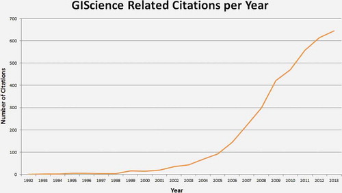
When searching for the phrases “geographical information science,” “geographic information science,” or the term “GIScience” in the Web of Science database, a total of 480 publications can be found (January 2014). The first publication indexed in this database dates back to 1992, and the number of articles being published has steadily increased ever since (). The three peaks indicated in roughly correspond to the three phases of GIScience research identified in this article, while displays the number of citation received per year.
Figure 2. ISI-Indexed GIScience related publications per year.
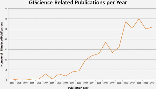
Figure 3. GIScience-related articles: number of citations per year.
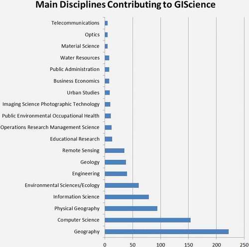
Using the same search criteria and keywords, we analyzed which disciplines are the main contributors to GIScience research (). Hereby we used a threshold of five publications (of a total of 433). indicates that over 35% of the total publications matching our search criteria fall into the domain of the computer sciences, whereas only roughly 22% fall into the category of Physical Geography. Geography constitutes the largest component with just over 51%; however, also disciplines such as the Information Sciences (~18%), Ecology (~14%), Engineering (~9%), Geology (~9%) and Remote Sensing (~8%) play a significant role.
Figure 4. Main disciplines contributing to GIScience publications according to the ISI Web of Science database.
Is GIScience a science at all?
The ongoing debate surrounding the question of whether GIScience is a science or not is nearly as old as the field itself. Therefore, it has received much attention in literature and is a commonly discussed theme among GIScientists, who feel the need to defend their discipline to outsiders and to promote it as a justifiable field of research and teaching (Reitsma Citation2013). Since this issue has been recently comprehensively and, as we feel, very convincingly and appropriately addressed by F. Reitsma, we will keep this section very short and refer mainly to her line of arguments.
To determine whether GIScience is a science or not, one may look at the bounds of the term “science” itself. However, these are by no means clearly or uniformly defined, a problem which is commonly known as the “demarcation problem” (Reitsma Citation2013). The demarcation problem constitutes the issue of separating science from pseudo-science, anti-science, or para-science. This problem has historically been based on the discordance of defining science based on a scientific method, as opposed to a universal set of sufficient demarcation criteria (Reitsma Citation2013). However, defining science based on a scientific method raises an entirely new debate as to the nature of a scientific method, which has been broadly discussed, yet has not resulted in a uniform or coherent conclusion. Reitsma (2013, 215) states that “if we agree that science lacks a definitive and objective methodology, we might happily throw GIScience in the melee, yet we have not yet solved the problem of demarcating science, if it cannot be done on its method.” Assuming the alternate means of defining science, namely, based on a universal set of demarcation criteria, is also problematic, since most philosophers doubtfully regard the existence of a set of sufficient conditions which may be used to demarcate science from non-science (Reitsma Citation2013). Thus, there is increasing agreement on the fact that there may not be any clearly definable criteria for demarcating science, which subsequently means that there is no consensus about the nature of science itself (Reitsma Citation2013). Nevertheless, there are a number of criteria, which an increasing number of philosophers of science agree on as being central to demarcating science. Such key criteria include, for instance, simplicity, predictive accuracy, coherence with known facts, as well as testability (Stamos Citation2007).
Multidisciplinary versus interdisciplinary
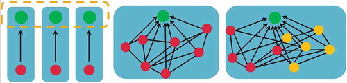
To characterize and distinguish the unique structure of a multidisciplinary discipline, as opposed to a unified academic discipline, it is perhaps essential to look at the way an academic discipline is defined. Repko (2008, 4) defines such as “a particular branch of learning or body of knowledge whose defining elements, phenomena, assumptions, epistemology, concepts, theories, and methods distinguish it from other knowledge formations.” From this definition alone it becomes evident that GIScience does not fulfill the premises it entails, in the sense that it is not a closed entity, but rather draws on the theories, concepts, and methods provided by other disciplines. Since the academic community, including institutions, funding agencies, and journals, require a field to define itself under some sort of umbrella term, in order to account for academic credibility and recognition, but also to be eligible for funding, it is essential to take a look at how GIScience fits under such an umbrella term. GIScience is often termed as “interdisciplinary,” “multidisciplinary,” “transdisciplinary,” or even “multiparadigmatic”; however, the usage of these terms seems to be synonymous, although they strongly differ in meaning. Therefore, we aim to define the abovementioned terms in order to subsequently determine where GIScience can be placed. Jantsch (Citation1972) already identified three forms of collaborative activity amongst scholars from different fields, namely, multidisciplinary, interdisciplinary, and transdisciplinary research. He describes multidisciplinary research as a research scenario, with scholars from different disciplines collaborating in a manner which upholds the autonomy of each separate discipline, and that does not challenge the underlying disciplinary or theoretical structures. The second scenario, namely, interdisciplinary research is described as the disciplinary-transcending collaboration between scholars, involving a uniform terminology, methodology, or research framework as the interface between the various disciplines. And the last scenario of transdisciplinary research is said to engage in a “mutual interpenetration of disciplinary epistemologies” (Jantsch Citation1972, 104). Furthermore, Gioia and Pitre (1990, 585) define a paradigm as “a general perspective or way of thinking that reflects fundamental beliefs and assumptions about the nature of organizations,” which in turn makes a multiparadigmatic field one where many such perspectives or schools of thinking collaborate in the production of knowledge. Based on these definitions, we regard the field of GIScience to be of multidisciplinary and multiparadigmatic nature, because of the manner in which experts from different fields and with different backgrounds contribute to the body of knowledge, while still remaining autonomous in their various fields. depicts these differences in intensity and quality of interactions graphically.
Figure 5. Multidisciplinary research (left), interdisciplinary research (middle), and transdisciplinary research (right), after Tress, Tress, and Fry (Citation2003), modified.
For a field as comprehensive as GIScience, the use of just one paradigm would result in a too narrow perception of its multifaceted nature. One discipline alone could by no means offer all the necessary input for the theories, concepts, and methods of GIScience, since these require a broader outlook in order to break down their complexity and offer solutions. Therefore, it is essential for GIScience research to transcend the boundaries of various disciplines and paradigms, all bearing profoundly different assumptions and thereby making a valuable contribution to the body of knowledge.
“The most difficult thing in science, as in other fields, is to shake off accepted views” (Sarton Citation1929/1959, 88). This quote reflects the challenge that GIScience and other multidisciplinary fields are facing today. In the established and somewhat rigid views of academia, a field which cannot be pigeonholed or distinctly defined as a single comprehensive domain often finds itself in a less favorable position, compared to a unified and distinct academic field. This is reflected both in academic credibility given to the research resulting from such a field, as well as funding and the availability of specialized journals.
Discussion
GIScience: a multiparadigmatic field (or an own scientific discipline)?
Why is this discussion – discipline versus sub-discipline versus multidisciplinary field – relevant at all? According to Reitsma (Citation2013), it is important to justify the field of GIScience as a science in order to receive funding from agencies. She states that funding agencies favor “hard” sciences, which work with empirical methods and produce substantial results, as opposed to “soft” sciences, whose contribution is often not sufficiently recognized (Reitsma Citation2013). Furthermore, Wright, Goodchild, and Proctor (Citation1997) argue that the term “science” is often used synonymously with the term “research” and that it therefore functions as a “crude but convenient shorthand for academic legitimacy” (Wright, Goodchild, and Proctor Citation1997, 354). Reitsma (Citation2013) also points out that underpinning the label of science leads to more credibility for arguments or evidence gained within a field and, therefore, states that there may well be good reason for “a bit of scientific gerrymandering” (Reitsma Citation2013, 219) in order to include GIScience within the realm of sciences.
Given that there seems to be no clear demarcation of science itself, placing GIScience under the umbrella term of science is a difficult task and can be approached in various manners. One such approach was taken by Reitsma (Citation2013), who compared some examples taken from the field of GIScience against various scientific key criteria (). Another approach was taken by Goodchild (Citation2004b), who bases his arguments on Anselin’s concept of spatial heterogeneity and Tobler’s first law of Geography and points out that GIScience has law-like statements. Furthermore, it has been argued that GIScience is based on inductive methods, which leads us to reason that it may belong to the humanities rather than the natural sciences. In the following section, these three approaches are briefly outlined and discussed and the importance attached to being labeled as a science is examined.
Attempting to position GIScience as an own scientific discipline
Adherence to key criteria central to a scientific discipline
Reitsma (Citation2013) examined a number of criteria, which an increasing number of philosophers of science agree on as being central to demarcating science, in the context of GIScience research. Such key criteria include, for instance, simplicity, predictive accuracy, coherence with known facts, as well as testability (Stamos Citation2007).
Table 3. Scientific key criteria and their application in the field of GIScience according to Reitsma (Citation2013).
Reitsma (Citation2013) concludes that GIScience may well pass as a science, if defined on the basis of the key-criteria identified by Stamos (Citation2007), as it contains significant aspects of most criteria. However, she goes on to mention that it is difficult to define a science based on a small list of criteria, since there may well be further noteworthy criteria to be considered such as the generality of results (Reitsma Citation2013). She also notes that GIScience does not study the world as such, in contrast to most other sciences, but rather studies representations of the world in terms of geographic information and considers the procedures involved in gathering, managing, analyzing, and visualizing such information. Therefore, she concludes that GIScience cannot exist independently from other sciences, but rather “It exists in symbiosis with other disciplines, such as geography and psychology, which guide data collection and other information needs” (Reitsma Citation2013, 219).
The validity of laws and principles in GIScience
Goodchild (Citation2004b) states that “all fields of scientific activity serve to simplify the world around us through the identification of general principles (…)” and from this, draws the conclusion that “principles therefore form the foundation of most learning in science” (Goodchild Citation2004b). Therefore, Goodchild (Citation2004b) attempts to justify GIScience as a science on the basis of its dependence on scientific laws and principles.
Goodchild (Citation2004b) concludes that the merits of GIScience as a science are indeed attributed to the foundation on such, and many more, scientific principles. However, he concedes that there is currently little consensus as to the underlying principles of GIScience and that it is “hard to find clear statements of the founding principles of the emerging discipline of GIScience as it is to find clear statements of the founding principles of Geography” (Goodchild Citation2004b). Therefore, although Goodchild (Citation2004b) is convinced of the validity of GIScience as a field of science based on its foundation on scientific principles, these are not universally recognized as adequate criteria and therefore the debate may well continue. lists four main principles identified by Goodchild and adds their respective relevance to GIScience. We may also conclude that it would be a too much reductionist view to consider GIScience as an offshoot of information science, a danger which has already been identified by Goodchild (Citation2006). Indeed, some GIScientists today occupy positions in computer science departments. One of the arguments for GIScience has been that it represents a relatively well-defined area of information science, and that as a result, it may be possible to make more substantial progress than in the larger discipline and perhaps eventually to generalize the results of GIScience to the larger context. We therefore need to discuss if and how GIScience is embedded in the social sciences and humanities, what are the specificities of the spatial approach in the broader context of ICT, and what GIScience can in turn contribute to this broader context.
Table 4. Main principles identified by Goodchild (Citation2004b), adopted and extended, and relevance to GIScience.
GIScience as a social science?
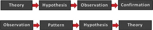
As reasoned by Haklay (Citation2012) in his paper entitled “Geographic Information Science: Tribe, badge and Sub-Discipline,” the field of GIScience is based on an inductive rather than deductive approach. While deductive methods begin with a theory, which is then extended to a hypothesis, and subsequently either confirmed or discarded depending on the observations (tests) carried out ( upper part), inductive methods work the other way around, building theories on the basis of observations ( lower part). Inductive approaches (also referred to as “bottom-up” approaches) work with initial observations and, based on these, aim to detect patterns and regularities, which may then lead to the formulation of hypotheses and, ultimately, theories.
Figure 6. Inductive “bottom-up” workflow (upper part) and deductive “top-down worklows” (bottom).
Max Born, a Nobel-Prize winning physicist, states that induction is the process in which a number of observations may be generalized into a general rule (Born Citation1949). He concludes that although there is no definite criterion for the validity of an inductive rule, there is a scientfic code which defines the criteria necessary for validifying an induction. However, he refrains from specifying what such a code may entail and stresses that it may well be rejected by other members of the scientific community, since there is no guarantee that they will accept the same criteria for defining valid induction. Therefore, he concludes that induction may be considered as a meta-physical principle, “namely something beyond physics” (Born Citation1949,7)
In this context, one could argue that a discipline which is based on inductive principles may be more suited within the realm of the humanities, rather than the natural sciences. As defined by Longmans Dictionary of Contemporary English, Science is “knowledge about the world, especially based on examining, testing, and proving facts.” In this sense, one would expect a field considered as a science to work in a deductive manner, that is, formulating theories and hypotheses and then examining, testing, and proving these in order to be able to either confirm or reject them.
If we think about the processes which take place in GIScience, however, it becomes evident that it does indeed – at least partially – implement an inductive workflow. GIScience develops methodologies to address problems or research challenges which arise as a result of the emergence of new GIS tools and technologies (Haklay Citation2012). These methodologies may then in turn lead to the development of a founded theoretical understanding of both the technologies themselves, as well as the impacts these have on society (Haklay Citation2012). For example, GIScience addresses issues of ethics and privacy, which emerged as a direct result of the development and implementation of GI-Software. The issue of ethics and privacy were addressed in both the research agenda by the UCGIS, as well as that by Michael Goodchild and therefore seems to be a key theme of GIScience.
For this reason, we herein argue that GIScience cannot soley be considered as a natural “hard” science. Rather its close ties to the humanities must be acknowledged, both on the basis of its inductive nature and on the basis of its thematic links to social science disciplines. However, certain other branches of GIScience most certainly have a place within the “hard” sciences, as demonstrated by Reitsma (Citation2013) and Goodchild (Citation2004b). This leads us to conclude that GIScience is of dichotomic nature, rather than being a coherent whole, which can be placed under the umbrella term of “science” or “humanity.”
Conclusion
In this article, we started from the hypothesis that GIScience is a multidisciplinary and multiparadigmatic field – rather than attempting to demarcate exact boundaries for GIScience as a discipline. It is safe to say that GIScience is a fast developing field with fuzzy boundaries, that there is a not very clear understanding of what it is and that many scientists may use other terminology when using core concepts of GIScience. We tried to analyze this dynamic field on the basis of scientific literature and to assess the multidisciplinary and multiparadigmatic nature of GIScience. The first part seems to be easy: counting publications and citations. Yet, when a field misses clear common and widely agreed definitions, clear terminologies and an understanding of core concepts, an attempt to count publications with certain words in them may be too straightforward and maybe flawed.
This article suggests a pluralistic, complex, and multiparadigmatic vision of GIScience. We are aware that there are limits to this thought. The validity of our conclusions mainly depends on the key peer-reviewed literature identified. There is a danger that this view is biased toward opinions in highly developed countries and articles written in English language only. We may miss aspects which would arise from a multi-cultural, multi-lingual perspective. One of the main lessons we draw from this investigation is that GIScience is undergoing a rather dynamic nonlinear process of change than a rational and linear one. But we believe that such a change is needed. Today’s “big problems” are complex, data-intensive, and often require to work collaboratively to solve such complex problems. Such collaboration requires low latency information exchange and a certain degree of common understanding of the methods and tools used.
When we conclude that GIScience is a multidisciplinary and multiparadigmatic field, then the exact boundaries to other disciplines are less relevant. It is sometimes believed that this is generally true in an era when science is more and more collaborative and multidisciplinary (e.g., Couclelis Citation2012). Reitsma (Citation2013) argues that the domain addressed by GIScience is nevertheless well-defined and persistent and that therefore GIScience is unlikely to be absorbed into one of its intersecting disciplines: geography, computer science, or information science. Being a multidisciplinary and multiparadigmatic field may bear a potential for interaction with a broader domain of spatial information sciences but faces the risk to be not flagged out well enough for funding agencies, education evaluation systems, and other kind of peer reviews, which often relay on predefined categories. In fact, the linkage of research and education programmers coupled with responsibility for outreach and professional education is increasingly relevant to the instructional component of output and a defining characteristic of the particular higher education institution. Programs which are clearly “earmarked” in respect to recognizable disciplines may have advantages in a competitive higher education market. In addition, when concluding that GIScience is a multidisciplinary and multiparadigmatic field which is strongly related to ICT developments including sensors, the Internet of Things, or big data analytics, fundamental questions about emerging technologies need to be formulated. GIScience needs to keep up with such developments so that GIScientists can ask questions about the spatiotemporal representations that are needed. They need to critically reflect and engage. This may make them distinct from, for example, computer science.
The co-existence of sets of distinctive portfolios of methods and practices in GIScience also reveals that Kuhn’s model of normal science interrupted by occasional revolutions may not be relevant. Nevertheless, such an argumentation which favors disciplinary recognisability is too short-minded. New fields such as neurosciences or nanotechnologies would not have gained so much interest. The key might be the public recognition of “the Geo-domain.” Even the big players like Google help to promote the GIScience field – or open up the ground for it to develop further. We may conclude that one of the most problematic issues remaining is the naming dilemma: is it GIScience, geospatial science, Geoinformatics, Geocomputation, or may we come up with another term every few years? Naming and branding may be more important as many scientists think, for instance, when dealing with research funding organizations. Even more subtle, we may not be able to define the “we,” that is, we will not be able to define the community and to tell others who “we” are if we (sic!) are not able to speak with a unified voice.
References
- Aitken, S., and M. P. Kwan. 2010. “GIS as Qualitative Research: Knowledge, Participatory Research, and the Politics of Affect.” In Handbook of Qualitative Geography, edited by D. DeLyser, S. Herbert, S. Aitken, M. Crang, and L. McDowell, 287–304. London: SAGE.
- Anselin, L. 1988. Spatial Econometrics: Methods and Models. Vol. 4. Berlin: Springer.
- Atzmanstorfer, K., and T. Blaschke. 2013. “Geospatial Web: A Tool to Support the Empowerment of Citizens through E-Participation?” In Handbook of Research on E-Planning: Icts for Urban Development and Monitoring, edited by C. Nunes Silva, 144–171. Hershey, PA: IGI-Global.
- Blaschke, T., K. Donert, F. Gossette, S. Kienberger, M. Marani, S. Qureshi, and D. Tiede. 2012. “Virtual Globes: Serving Science and Society.” Information 3: 372–390. doi:10.3390/info3030372.
- Blaschke, T., and C. Eisank. 2012. “How Influential is Giscience?” In Proceedings of Giscience 2012, 7th International Conference on Geographic Information Science, edited by N. Xiao, M.-P. Kwan, and H. Lin. Columbus, OH: Springer.
- Blaschke, T., G. J. Hay, M. Kelly, S. Lang, P. Hofmann, E. Addink, R. Feitosa, et al. 2014. “Geographic Object-based Image Analysis – Towards A New Paradigm.” ISPRS Journal of Photogrammetry and Remote Sensing 87 (1): 180–191. doi:10.1016/j.isprsjprs.2013.09.014.
- Blaschke, T., and J. Strobl. 2010. “Geographic Information Science Developments.” GisScience Zeitschrift Für Geoinformatik 23 (1): 9–15.
- Blaschke, T., J. Strobl, and K. Donert. 2011. “Geographic Information Science: Building a Doctoral Programme Integrating Interdisciplinary Concepts and Methods.” Procedia – Social and Behavioral Sciences 21: 139–146. doi:10.1016/j.sbspro.2011.07.013.
- Blaschke, T., J. Strobl, L. Schrott, R. Marschallinger, F. Neubauer, A. Koch, E. Beinat, et al. 2012. “Geographic Information Science as a Common Cause for Interdisciplinary Research.” In Bridging the Geographic Information Sciences. Springer Lecture Notes in Geoinformation and Cartography, edited by J. Gensel, D. Josselin, and D. Vandenbroucke, 411–427. Berlin: Springer.
- Born, M. 1949. Natural Philosophy of Cause and Chance. Oxford: Clarendon Press.
- Butler, D. 2006. “Virtual Globes: The Web-Wide World.” Nature 439: 776–778. doi:10.1038/439776a.
- Caron, C., S. Roche, D. Goyer, and A. Jaton. 2008. “Giscience Journals Ranking and Evaluation: An International Delphi Study.” Transactions in GIS 12 (3): 293–321. doi:10.1111/j.1467-9671.2008.01106.x.
- Chrisman, N. R. 2005. “Full Circle: More than Just Social Implications of GIS.” Cartographica: The International Journal for Geographic Information and Geovisualization 40 (4): 23–35. doi:10.3138/8U64-K7M1-5XW3-2677.
- Chrisman, N. R. 2012. “A Deflationary Approach to Fundamental Principles in Giscience.” In Are There Fundamental Principles in Geographic Information Science. Tobler Lecture Event 2012, edited by F. J. Harvey, 42–64. CreateSpace Independent Publishing Platform. https://www.createspace.com/3932452
- Clarke, K. C. 1997. Getting Started with Geographic Information Systems. Upper Saddle River, NJ: Prentice Hall.
- Couclelis, H. 2012. “Climbing on a Milestone for a Better View: Goodchild’s ‘Geographical Information Science’ Paper as Vantage Point and Ground for Reflection.” International Journal of Geographical Information Science 26 (12): 2291–2300. doi:10.1080/13658816.2012.713959.
- Craglia, M., M. F. Goodchild, A. Annoni, G. Camara, M. Gould, W. Kuhn, and D. Mark, et al. 2008. “Next-Generation Digital Earth: A Position Paper from the Vespucci Initiative for the Advancement of Geographic Information Science.” International Journal of Spatial Data Infrastructures Research 3: 146–167.
- Crampton, J. W. 2009. “Cartography: Maps 2.0.” Progress in Human Geography 33 (1): 91–100. doi:10.1177/0309132508094074.
- Crampton, J. W. 2010. Mapping: A Critical Introduction to Cartography and GIS. Oxford: Wiley-Blackwell.
- Crampton, J. W., M. Graham, A. Poorthuis, T. Shelton, M. Stephens, M. W. Wilson, and M. Zook. 2013. “Beyond the Geotag: Situating “Big Data” and Leveraging the Potential of the Geoweb.” Cartography and Geographic Information Science 40 (2): 130–139. doi:10.1080/15230406.2013.777137.
- Egenhofer, M. J., and R. D. Franzosa. 1991. “Point-Set Topological Spatial Relations.” International Journal of Geographical Information Systems 5 (2): 161–174. doi:10.1080/02693799108927841.
- Elwood, S., M. F. Goodchild, and D. Z. Sui. 2012. “Researching Volunteered Geographic Information: Spatial Data, Geographic Research, and New Social Practice.” Annals of the Association of American Geographers 102 (3): 571–590. doi:10.1080/00045608.2011.595657.
- Fischer, F. 2012. “Geotagging and the City – Understanding the Use of Social Location Applications in Urban Space.” PhD thesis, Paris-Lodron University Salzburg.
- Fisher, P. 2001. “Citations to the International Journal of Geographical Information Systems and Science: The First 10 Years.” International Journal of Geographical Information Science 15: 1–6. doi:10.1080/13658810109699908.
- Frank, A. U. 2012. “GIS Theory – the Fundamental Principles in Giscience: A Mathematical Approach.” In Are There Fundamental Principles in Geographic Information Science. Tobler Lecture Event 2012, edited by F. J. Harvey, 12–41. CreateSpace Independent Publishing Platform. https://www.createspace.com/3932452
- Gioia, D. A., and E. Pitre. 1990. “Multiparadigm Perspectives on Theory Building.” The Academy of Management Review 15 (4): 584–602.
- Goodchild, M. F. 1991. “Geographic Information Systems.” Progress in Human Geography 15 (2): 194–200.
- Goodchild, M. F. 1992. “Geographical Information Science.” International Journal of Geographical Information Systems 6: 31–45. doi:10.1080/02693799208901893.
- Goodchild, M. F. 2004a. “Giscience, Geography, Form, and Process.” Annals of the Association of American Geographers 94: 709–714.
- Goodchild, M. F. 2004b. “The Validity and Usefulness of Laws in Geographic Information Science and Geography.” Annals of the Association of American Geographers 94: 300–303. doi:10.1111/j.1467-8306.2004.09402008.x.
- Goodchild, M. F. 2006. “Giscience Ten Years after Ground Truth.” Transactions in GIS 10 (5): 687–692. doi:10.1111/j.1467-9671.2006.01022.x.
- Goodchild, M. F. 2007a. “Citizens as Sensors: The World of Volunteered Geography.” Geojournal 69 (4): 211–221. doi:10.1007/s10708-007-9111-y.
- Goodchild, M. F. 2007b. “Geography prospers from GIS.” ArcWatch, April. http://www.esri.com/news/arcwatch/0407/ feature.html.
- Goodchild, M. F. 2008. “Commentary: Whither VGI? Whither VGI?” Geojournal 72: 239–244. doi:10.1007/s10708-008-9190-4.
- Goodchild, M. F. 2009. “Geographic Information Systems and Science: Today and Tomorrow.” Annals of GIS 15 (1): 3–9. doi:10.1080/19475680903250715.
- Goodchild, M. F. 2010. “Twenty Years of Progress: Giscience in 2010.” Journal of Spatial Information Science 1: 3–20.
- Goodchild, M. F., and J. A. Glennon. 2010. “Crowdsourcing Geographic Information for Disaster Response: A Research Frontier.” International Journal of Digital Earth 3: 231–241. doi:10.1080/17538941003759255.
- Haklay, M. 2012. “Geographic Information Science: Tribe, Badge and Sub-Discipline.” Transactions of the Institute of British Geographers 37: 477–481. doi:10.1111/j.1475-5661.2012.00541.x.
- Harvey, F. 2013. “A New Age of Discovery: The Post-Gis Era.” In Gi_Forum 2013. Creating the Gisociety, edited by T. Jekel, A. Car, J. Strobl, and G. Griesebner, 272–281. Berlin: Wichmann-Verlag.
- Harvey, F., and N. R. Chrisman. 2004. “The Imbrication of Geography and Technology: The Social Construction of Geographic Information Systems.” In Geography and Technology, edited by S. D. Brunn, S. L. Cutter, and J. W. Harrington, 65–80. Dordrecht: Kluwer.
- Harvey, F. J. 2012. (ed.). Are There Fundamental Principles in Geographic Information Science. Tobler Lecture Event 2012. CreateSpace Independent Publishing Platform, United States, pp. 100. https://www.createspace.com/3932452
- Jantsch, E. 1972. “Towards Interdisciplinarity and Transdisciplinarity in Education and Innovation.” In Interdisciplinarity: Problems of Teaching and Research in Universities, edited by OECD, 97–121. Paris: OECD/CERI.
- Kemp, K., W. Kuhn, and C. Brox. 2012. “A Delphi Survey to Rate Giscience Publication Outlet.” In Multidisciplinary Research on Geographical Information in Europe and Beyond Proceedings of the AGILE’2012 International Conference on Geographic Information Science, edited by J. Gensel, D. Josselin, and D. Vandenbroucke, 268–271. Avignon: Institute of Electrical and Electronics Engineers.
- Kuhn, T. 1962. The Structure of Scientific Revolution. Chicago, IL: University of Chicago Press.
- Kwan, M.-P. 2012. “The Uncertain Geographic Context Problem.” Annals of the Association of American Geographers 102 (5): 958–968. doi:10.1080/00045608.2012.687349.
- Leetaru, K. H., S. Wang, A. Padmanabhan, E. Shook, and E. Schook. 2013. “Mapping the Global Twitter Heartbeat: The Geography of Twitter.” First Monday, 18 (5). http://journals.uic.edu/ojs/index.php/fm/article/view/4366/3654#author. doi:10.5210/fm.v18i5.4366.
- Leszczynski, A. 2009a. “Poststructuralism and GIS: Is There a ‘Disconnect’?” Environment and Planning D: Society and Space 27: 581–602. doi:10.1068/d1607.
- Leszczynski, A. 2009b. “Quantitative Limits to Qualitative Engagements: GIS, Its Critics, and the Philosophical Divide.” The Professional Geographer 61 (3): 350–365. doi:10.1080/00330120902932026.
- Li, L., and M. F. Goodchild. 2012. “Constructing Places from Spatial Footprints.” In Proceedings of the 1st ACM SIGSPATIAL International Workshop on Crowdsourced and Volunteered Geographic Information, 15–21. New York: ACM.
- Liu, S., and L. Palen. 2010. “The New Cartographers: Crisis Map Mashups and the Emergence of Neogeographic Practice.” Cartography and Geographic Information Science 37: 69–90. doi:10.1559/152304010790588098.
- Longley, P. A., M. F. Goodchild, D. J. Maguiere, and D. W. Rhind. 2005. Geographic Information Systems and Science. 2nd ed. New York: Wiley.
- Mark, D. M. 2003. “Geographic Information Science: Defining the Field.” In Foundations of Geographic Information Science, edited by M. Duckham, M. F. Goodchild, and M. F. Worboys, 3–18. London: Taylor & Francis.
- Openshaw, S. 1991. “A View on the GIS Crisis in Geography, or, Using GIS to Put Humpty-Dumpty Back Together Again.” Environment and Planning A 23: 621–628.
- Parr, D. A., and Y. Lu. 2010. “The Landscape of Giscience Publications 1997–2007: An Empirical Investigation with Latent Semantic Analysis.” Transactions in GIS 14: 689–708. doi:10.1111/j.1467-9671.2010.01228.x.
- Pavlovskaya, M. 2006. “Theorizing with GIS: A Tool for Critical Geographies?” Environment and Planning A 38 (11): 2003–2020. doi:10.1068/a37326.
- Raper, J. 2009. “Geographical Information Science.” In Annual Review of Information Science and Technology, edited by B. Cronin, Vol. 43, 1–117. Medford, NJ: Information Today.
- Reitsma, F. 2013. “Revisiting the ‘Is Giscience a Science?’ Debate (or Quite Possibly Scientific Gerrymandering).” International Journal of Geographical Information Science 27 (2): 211–221. doi:10.1080/13658816.2012.674529.
- Repko, A. F. 2008. Interdisciplinary Research: Process and Theory. Los Angeles, CA: SAGE.
- Richardson, D. B. 2013. “Real-Time Space–Time Integration in GIScience and Geography: Space–Time Integration in Geography and GIScience.” Annals of the Association of American Geographers 103 (5): 1062–1071.
- Sarton, G. 1929/1959. “Science in the Renaissance.” In The Civilization of the Renaissance, edited by J. W. Thompson, G. Rowley, F. Schevill, and G. Sarton, 75–95. New York: Un-gar.
- Schuurman, N. 2000. “Trouble in the Heartland: GIS and Its Critics in the 1990s.” Progress in Human Geography 24: 569–590. doi:10.1191/030913200100189111.
- Schuurman, N. 2006. “Formalization Matters: Critical GIS and Ontology Research.” Annals of the Association of American Geographers 96: 726–739. doi:10.1111/j.1467-8306.2006.00513.x.
- Schuurman, N., and A. Leszczynski. 2006. “Ontology-Based Metadata.” Transactions in GIS 10: 709–726. doi:10.1111/j.1467-9671.2006.01024.x.
- Stamos, D. N. 2007. “Popper, Laws, and the Exclusion of Biology from Genuine Science.” Acta Biotheoretica 55: 357–375. doi:10.1007/s10441-007-9025-6.
- Stefanidis, A., A. Crooks, and J. Radzikowski. 2012. “Harvesting Ambient Geospatial Information from Social Media Feeds.” Geojournal 78 (2): 1–20.
- Sui, D. Z. 1994. “GIS and Urban Studies: Positivism, Post-Positivism, and Beyond.” Urban Geography 15: 258–278. doi:10.2747/0272-3638.15.3.258.
- Sui, D. Z. 2004. “Tobler’s First Law of Geography: A Big Idea for A Small World? A Big Idea for A Small World?” Annals of the Association of American Geographers 94: 269–277. doi:10.1111/j.1467-8306.2004.09402003.x.
- Sui, D. Z., and D. deLyser. 2012. “Crossing the Qualitative–Quantitative Chasm I: Hybrid Geographies, the Spatial Turn, and Volunteered Geographic Information (VGI).” Progress in Human Geography 36 (1): 111–124. doi:10.1177/0309132510392164.
- Takhteyev, Y., A. Gruzd, and B. Wellman. 2012. “Geography of Twitter Networks.” Social Networks 34 (1): 73–81. doi:10.1016/j.socnet.2011.05.006.
- Taylor, P. J., and M. Overton. 1991. “Further Thoughts on Geography and GIS: A Preemptive Strike?” Environment and Planning A 23: 1087–1094.
- Tress, B., G. Tress, and G. Fry. 2003. “Potential and Limitations of Interdisciplinary and Transdisciplinary Landscape Studies.” In Interdisciplinarity and Transdisciplinarity in Landscape Studies: Potential and Limitations, edited by B. Tress, G. Tress, A. Van der Valk, and G. Frey, 182–192. Delta Series No. 2. Wageningen: Delta Program.
- Tsou, M. H., and M. Leitner. 2013. “Visualization of Social Media: Seeing A Mirage or a Message?” Cartography and Geographic Information Science 40 (2): 55–60. doi:10.1080/15230406.2013.776754.
- UCGIS. 1996. “Research Priorities of the University Consortium for Geographic Information Science.” Cartography and Geographic Information Systems 23 (3): 115–127.
- Weaver, G., and D. Gioia. 1994. “Paradigms Lost: Incommensurability vs Structurationist Inquiry.” Organization Studies 15 (4): 565–589. doi:10.1177/017084069401500404.
- Wright, D. J., M. F. Goodchild, and J. D. Proctor. 1997. “Demystifying the Persistent Ambiguity of GIS as ‘Tool’ Versus ‘Science’.” Annals of the Association of American Geographers 87: 346–362. doi:10.1111/0004-5608.872057.
- Zook, M., M. Graham, T. Shelton, and S. Gorman. 2010. “Volunteered Geographic Information and Crowdsourcing Disaster Relief: A Case Study of the Haitian Earthquake.” World Medical and Health Policy 2: 6–32. doi:10.2202/1948-4682.1069.