
ABSTRACT
The current popularity of government open data platforms as a way to share geospatial data has created an opportunity for government to receive direct feedback and edits on this very same data. This research proposes four models that can define how government accepts direct edits and feedback on geospatial data. The four models are a “status quo” of open data provision, data curation, data mirroring, and crowdsourcing. These models are placed on a continuum of government control ranging from high levels of control over data creation to a low level of control. Each model is discussed, with relevant challenges highlighted. These four models present an initial suite of options for governments looking to accept direct edits from data end users and can be framed as a partial realization of many of the principles of open government. Despite the varied potential of these approaches, they generate a shift in locus of control away from government, creating several areas of risk for government. Of these models, near-term interest may focus on data curation and data mirroring as evolutionary, rather than revolutionary steps that expand on the simple provision of open data.
1. Introduction
Governments at all levels collect, maintain, and analyze spatial data as a key support to program delivery and decision-making (Janssen, Charalabidis, and Zuiderwijk Citation2012; Zuiderwijk and Janssen Citation2014). A recent trend toward government provision of “open data,” that is, internal government data placed online, for no cost, with minimal restrictions on use, has opened up citizen access to select government data sources (Kulk and Van Loenen Citation2012; Zuiderwijk and Janssen Citation2014). Moving beyond the enhancement of simple access to information, the provision of open data presents an opportunity for governments to create a conduit for direct feedback, edits, or commentary on the data itself (Johnson and Robinson Citation2014; Sieber and Johnson Citation2015). This type of direct editing of open data can be considered as a general realization of open government, namely a suite of initiatives where governments aim to increase the transparency and accountability of their actions and decision-making, creating new avenues for citizen engagement (Alexopoulos, Loukis, and Charalabidis Citation2014; Conradie and Choenni Citation2014). Pressure for increased transparency, accountability, and citizen engagement is driven both externally from government by civil society actors, and also internally from the organization, as new data storage and delivery technologies, supported by philosophies that increasingly promote transparency, are adopted (Bates Citation2014; Johnson and Sieber Citation2013). This drive toward a more open government is also fueled through policies that seek to address a public desire to better track and even reduce the expenditures of government, broadly considered part of an agenda of neoliberalization (Bates Citation2013). This realization of a “government as platform” concept of enhanced data provision, but correspondingly reduced service or program spending, plays out in a spatial data context through an opening of the resource-intensive data collection and maintenance tasks of government (O’Reilly Citation2011) to input using procedures such as crowdsourcing (Brabham Citation2009; Haklay et al. Citation2014; Coleman Citation2013). This process can be conceptualized as a move from an expert-driven, top-down approach to data management, where government is the main authority for producing and distributing data, toward a hybrid one that has a distinct bottom-up component, based on the possible acceptance of contributed data (Elwood, Goodchild, and Sui Citation2013; Thatcher et al. Citation2015). These editors are typically volunteers, minimally compensated for their efforts (Budhathoki and Haythornthwaite Citation2013). This extension of data contribution from experts to nonpaid volunteers represents a change in the way that government geospatial data can be collected, updated, and managed, with an increasing number and diversity of individuals (Stephens Citation2013). Despite the interest in this use of volunteers to interact, edit, or update open government data, there is little coordinated effort to understand the mechanics and motivations behind this shift. In the further development of practical ways of supporting individual efforts to update government data, it is critical to consider how these new interactions are managed, exploited, and either develop or are abandoned.
The contribution of geospatial data by volunteers has been typically studied under the term of volunteered geographic information (VGI) (Goodchild Citation2007), though there are strong parallels to the more general and nonspatial phenomena of user-generated content (Hecht and Gergle Citation2010), crowdsourcing (Brabham Citation2009), and citizen science (Haklay Citation2013). The use of nonexperts for geospatial data collection has been widely explored in several contexts (Sui, Goodchild, and Elwood Citation2013), yet questions remain as to how this contributed data can be integrated into formal decision-making channels (Johnson and Sieber Citation2013; Bartenberger and Grubmüller Citation2014). In particular, what is the potential for nonexpert contributions to the data upon which government relies, to update, refine, and even suggest alterations? Existing government geospatial base map data, particularly rapidly changing infrastructure data, such as roads, buildings, and attributes of these objects, may be lacking in accuracy and completeness, creating a potential opportunity for volunteer efforts to improve this data (Haklay Citation2010). The primary challenge addressed in this research is to define current models of direct editing of government geospatial data, examining the potential for government to adopt contributed data. Implicit to this challenge is the definition of the constraints involved with government acceptance of volunteer edits. This is one of the many challenges of “openness,” broadly defined, where a move from closed data with traditional data protection and limited sharing practices is challenged, creating both a real and perceived risk for government. This concept of “risk” for government, and the importance of understanding government perception and management of risk, is real, with any move toward direct editing of geospatial data mediated by these risks (Conradie and Choenni Citation2014; Johnson and Sieber Citation2013). Four models are defined that illustrate how government may adopt open data editing practices as a complement to or even replacement for existing authoritative geospatial data gathering and management approaches. These models include a status quo open data approach, data curation, data mirroring, and crowdsourcing. These models are linked conceptually, and their definition provides a framing for how governments may accept data, with key challenges and constraints to adoption identified.
2. Challenges to government acceptance of contributed data
Governments have long accepted input from citizens. Within a democratic context, citizen participation in planning and government at its most basic level consists of voting at the ballot box to elect representative governments. Though critically important, this episodic and infrequent form of participation represents only a basic level of participation (Carver et al. Citation2001; Ghose and Huxhold Citation2001). Further efforts to either directly accept citizen input or to make citizens meaningful partners in decision-making and governance have taken varied forms, ranging from town hall meetings, focus groups, citizen membership on steering committees, the co-generation of policy and delivery of programs, and even direct democratic action (Ghose and Huxhold Citation2001; Haklay Citation2013; Lin Citation2013; Sæbø, Rose, and Flak Citation2008). The potential for digital engagement of citizens using Geographic Information Systems has long been proposed as a way to extend or reinvigorate the public participation process (Kingston et al. Citation2000; Rinner and Bird Citation2009). Brabham (Citation2009) specifically presents the possibility of crowdsourcing through digital means as an input into the public participation process, with urban planners accessing the “wisdom of the crowd,” and directing this input toward specific projects. Offenhuber (Citation2015) defines the concept of a “Participatory Infrastructure System,” where citizens, using mobile devices, act as mobile sensors, directly relaying information about the built and human landscape to city managers. This large-scale integration of nonexpert input into government operations and decision-making is mirrored in the VGI and citizen science literatures, where the potential for individuals to directly contribute to government-sponsored projects is highlighted (Budhathoki, Bruce, and Nedovic-Budic Citation2008; Connors, Lei, and Kelly Citation2012). Within the broad literature on VGI, crowdsourcing, and citizen science, there is an active thread indicating both the potential and perils of contributed data, forming a base on which this current work builds. From this review, two main challenges are identified: data quality (Cooper et al. Citation2011; Feick and Roche Citation2013) and ownership of data (Judge and Scassa Citation2010; Saunders, Scassa, and Lauriault Citation2012).
The quality of contributed data is a significant theme in the literature on characterizing VGI, and a persistent challenge in government use and adoption of contributed data (Johnson and Sieber Citation2013; Lin Citation2013). For example, when comparing expertly collected and authoritative data to data contributed by nonexpert amateurs, research has pointed to questions of technical accuracy of data gathering equipment, contributor motivations, jurisdiction of contributor, and the impacts of anonymity on data quality (Feick and Roche Citation2013; Goodchild Citation2007). Several studies examine the quality of crowdsourced geospatial data through comparisons of the volunteer-contributed base map OpenStreetMap (OSM) to national mapping agency data (Haklay and Weber Citation2008; Haklay Citation2010). OSM provides a test bed for the quality of contributed data as it is perhaps the best example of community-vetted data contribution by nonexperts. It is through these comparisons that the concept of “fitness-for-use” of VGI becomes a persistent theme in framing the understanding of VGI and citizen-contributed data quality (de Bruin, Bregt, and van de Ven Citation2001; Devillers et al. Citation2010; Feick and Roche Citation2013). Fitness for use considers that data available for use may be of variable quality (whether contributed by experts or amateurs), yet may in fact be of sufficient quality to support an intended use. Defining this fitness for use can depend on the level of integration of citizen contributions into government data sets. For example, if citizen contributions sit outside of government systems, acting in a purely supplementary (and thus, optional) role, the required quality of both data and rigor of contribution evaluation may be lower (Devillers et al. Citation2007). Comparatively, if citizen contributions are intended to be merged into official data sets, the level of quality required and scrutiny of contributions will be increased.
Fitness for use in a government context can be refined to fit with organizational needs and tolerance for the inherent risk of accepting contributed data (Feick and Roche Citation2013; Johnson and Sieber Citation2013). For example, how does contributed data actually integrate with specific government operations, and what is the tolerance of a particular government to the risk that can come from accepting contributed data? This builds directly on the fitness-for-use concept, in that contributed data may be suitable for one type of application (reporting municipal infrastructure issues) and yet unsuitable for another (modifying property boundaries). Implicit in this evaluation for each government is an assessment of what entails acceptable risk and also the installation of safeguards to protect both government and downstream data users until contributed data has been verified. This is a process that can require significant inputs of time and expertise on the part of the government agency. For example, contributors could choose to flag an issue for government follow-up or possibly manipulate the geometry of a building or road, which then triggers verification by a government expert or larger community of contributors (Offenhuber Citation2015). Each of these approaches requires a safeguard to ensure data quality, the former preventing citizen contributions from appearing until verified, and the latter reviewing them after appearance.
Recent scholarship has indicated that there are several legal issues to the use and adoption of VGI and contributed content (Judge and Scassa Citation2010; Saunders, Scassa, and Lauriault Citation2012). These include issues primarily around intellectual property and license, and seek to uncover who owns crowdsourced data, and how this data can be used by others (Judge and Scassa Citation2010). This is a critical question for two reasons: first, data ownership and license may permit or restrict government usage of contributed data, integration with existing government data, and hamper its ability to share data with others, particularly under an open license. Governments may face issues with accepting data from individuals through their own data collection system as users would need to acknowledge that they claim no right to the data or the database. Without such a clause, government would be at risk of having data contributors potentially remove their edits from a database. A second challenge would come from the integration of part or all of a separate database, such as OSM into a government database, which is then provided under a separate license than OSM (Saunders, Scassa, and Lauriault Citation2012). OSM currently uses a license that has a share-alike clause, where any significant portion of the OSM data incorporated into a “derivative” database must continue to be licensed under the same Open Database License (ODbL v.1.0), including a share-alike clause. This means that any derivative data set must then be shared with the same or compatible licensing as the current OSM database (for more information, see https://wiki.osmfoundation.org/wiki/License). Through a complex and emerging field of database licensing law and compatibility, this share-alike clause may restrict the potential for blended OSM-government data products to be created as this derivative database would need to be contributed back to OSM and be made available under a separate license than from the government open data license. For example, the United States Geologic Survey (USGS) notes that they cannot integrate OSM data into the USGS National Map since OSM data uses a Creative Commons Share-Alike license, while their work needs to be under the public domain (Wolf, McNinch, and Poore Citation2011).
3. Models of citizen editing of government spatial data
Given the opening up of government geospatial data, delivered as open data and the potential for incorporating direct edits into government geospatial data, there is potential to develop and consider approaches that government could use to support or facilitate this process. Four broad models are defined of how input into government geospatial data collection can be realized. These models include the status quo of open data, data curation, data mirroring, and acceptance of external crowdsourced data. These models are placed on a continuum from high levels of government control to lower levels of government control. Within each model, the constraints and tensions that can drive the selection of a model or models is highlighted.
3.1. Status quo open data
The creation of geospatial data within government follows a conventional arc: government agencies with direct mandates for environmental, economic, health, and social management employ scientific and para-scientific staff to collect data from and about citizens and their environment, to support the service provision and policy goals of government, broadly defined. For example, government scientific and research staff may collect data on drinking water quality to ensure that contaminants are below accepted guidelines. This information may be used to identify industrial polluters and issue health warnings to the general population. This approach allows government to maintain control over data, releasing findings only as digested reports or news bulletins, if at all (Bates Citation2014). The ways that governments can and do provide data is a rapidly changing area, moving away from this traditional form of delivering information. Instead of restricting the delivery of information, governments are placing raw data online as “open data,” a way to support access to government data with the aim of allowing citizens and other stakeholders to participate in and understand government functioning and service provision through their own scrutiny, analysis, and interpretation of raw data (Boulton et al. Citation2011; Kulk and Van Loenen Citation2012). Open data is typically provided according to a nonrestrictive license, and for no cost, allowing a broad range of stakeholders, whether citizens, private enterprises, or nonprofits to access and use government data for commercial and noncommercial purposes alike. The benefits of open data are considered to be varied, though few studies quantify the value empirically (Bonina Citation2013; Charalabidis, Loukis, and Alexopoulos Citation2014; Sieber and Johnson Citation2015). Typically, the government provision of open data is said to support government transparency, reduce costs of data sharing both within/between government agencies, and with other organizations, spur innovation in civic services, and support economic development (Janssen, Charalabidis, and Zuiderwijk Citation2012; Zuiderwijk and Janssen Citation2014). The level of government control over data in this model is high. Though government may consult with citizens to select data sets to release, ultimate control over data structure, format, level of detail, and critically, update frequency rests with the government (Robinson et al. Citation2009).
Despite the enthusiasm for open data, provision has several areas of implementation constraint. For example, significant challenges exist from an organizational perspective in deciding which data to make open, the format of that data, managing privacy constraints, such as what personally identifying data may need to be redacted, updating data sets, and lastly, measuring the use of data that has been made open (Alexopoulos, Loukis, and Charalabidis Citation2014; Conradie and Choenni Citation2014). Most notably, within this status quo model of direct editing, there are limited options for direct input. Though increasingly governments work with specific end user communities to select data sets for release, the ability to comment on or edit a specific piece of data is limited to contributing a “bug” or error report that could highlight missing or outdated data. This type of report would be contributed from end user to government, typically via an email, phone, or web contact form. Such changes may then be incorporated into subsequent data releases, but generally the updating of government open data is locked to the internal government update cycle, which can vary tremendously from government to government. This model of citizen editing is based around a passive connection between government and data user, where government provides a service with little tracking of its impact or effect. This unidirectional relationship involves government provision of data, with limited opportunity for end user contribution or feedback. Though invariably there is value in end user reports of errors or changes required, with a traditional open data model, there is limited support for feedback, and effectively no support for the direct editing of data.
3.2. Data curation
Moving beyond the simple provision of open data are models where data users are given a specific entry point into providing edits. One approach is a “data curation” model, where direct contributions are made to government data through a purpose-built interface that allows for an authoritative expert to vet or otherwise evaluate a proposed change or edit. This expert vetting provides a government employee or team with responsibility for geospatial data management, creating an opportunity to verify contributed data before it becomes part of the official government database. This data curation model is positioned as a compromise between the crowdsourced model detailed later and the traditional model of open data with little to no opportunity for direct input.
The data curation model provides a counter to the current enthusiasm for the potential of crowdsourced and community-vetted contributions to create high-quality, authoritative data (Brabham Citation2009; Dodge and Kitchin Citation2013). In VGI literature, there is a significant focus on establishing that user-contributed data contributed meets expected levels of quality or accuracy (Girres and Touya Citation2010; Goetz and Zipf Citation2013). Despite several promising assessments of the quality of VGI (Cooper et al. Citation2011; Goodchild and Li Citation2012), it is argued that for government use in such critical areas as infrastructure management, health care, services planning, and emergency plan development, that such contributed data faces significant constraints to adoption (Johnson and Sieber Citation2012, Citation2013). Though the temporal currency and broad scope of contributed data may have advantages compared to traditional data sets, the quality, accuracy, provenance, and even legitimacy of contributed data generally remain opaque (Feick and Roche Citation2013). These issues are all identified as critical barriers to the adoption of contributed data by government operations (Johnson and Sieber Citation2013). The data curation model responds to government concerns over data quality issues, including data provenance, accuracy, and completeness (Johnson and Sieber Citation2012). The data curation model can potentially overcome the data quality challenges of contributed data as user-submitted changes are not adopted directly, but rather serve as a specific flag for government to either accept, reject, or follow up on with an investigation if need be. An example of the data curation model in practice is the USGS National Map Corps program (https://my.usgs.gov/confluence/display/nationalmapcorps/Home), developed as a way to expedite and broaden the process of community feedback into the National Map, a nationwide, authoritative map of the United States (Bearden Citation2007; Budhathoki, Bruce, and Nedovic-Budic Citation2008; Wolf, McNinch, and Poore Citation2011). Volunteer map editors use online tools to update, correct, and verify components of the national topographic data set (typically structures of the built environment). Changes proposed by volunteer mappers are then verified by other mappers and by USGS staff before being incorporated into the National Map database. This process shows how users are engaged to both add new and edit existing features using a system that preserves government control over the editing, and provides a specific system for verifying changes.
Implementing a data curation model requires negotiation of both technical and organizational challenges. From a technical perspective, the development of a reporting tool and workflow that would support this type of contribution is needed. Additionally, any such data curation system must be done in a way that is efficient for municipal staff to handle and update, so as to not increase required human resources (Hartog et al. Citation2014; Johnson and Sieber Citation2013). Difficulties in learning and adapting to new technology, ostensibly designed to ease workload, is a cited constraint to the adoption of new technologies within government (Janssen, Charalabidis, and Zuiderwijk Citation2012; Johnson and Sieber Citation2012). As a result, such technical systems should be based around augmenting existing practices and technologies (Conradie and Choenni Citation2014; Sieber and Johnson Citation2015). A significant challenge to the data curation model is the recruitment of volunteers to contribute data. This is an acknowledged challenge with many VGI applications, where volunteer enthusiasm and dedication to contribute to a project can fluctuate dramatically over time (Byron and Curtis Citation2002; Cooper et al. Citation2011). The time and resources required for the maintenance of a core contributing volunteer base should not be underestimated (Budhathoki and Haythornthwaite Citation2013). Particularly if a government data curation platform is built to resemble the OSM editing interface, and indeed, duplicates many of the data creation or editing tasks, it may seem redundant to contributors to engage with both systems. Integral to this development and maintenance of a volunteer base is the quick response from government to contributions. As shown in Johnson and Sieber (Citation2012), when government asks for citizen input, it is critical that government be prepared to act on that input in a prompt and meaningful way. For example, if a citizen contribution within a data curation process is accepted, rejected, or reviewed, this status of the contribution needs to be communicated, showing that government has both received the request and it is being processed. Failure to acknowledge citizen contributions or to meaningfully incorporate or discuss reasons for rejection or modification can lead to a data curation model being seen as a “black box,” with no observable outcome from the citizen perspective. In this way, data curation can set up increased expectations of openness and transparency of government that may or may not be realized, depending on how the model would be implemented.
3.3. Data mirroring
The data curation model proposes a new conduit for data contributions, yet brings up questions of duplication of volunteer effort between government-specific editing interfaces and third-party interfaces, such as OSM. As an alternative or enhancement to data curation, government can use an existing external data set as a “mirror” to compare differences with existing municipal data, creating a list of issues to be investigated and potentially reconciled. From a geospatial data perspective, the most likely external data set that could be compared with existing municipal government data is OSM. This model of direct editing of government geospatial data has been proposed by the recent “Change Within” project from geospatial data company MapBox, OpenStreetMap.org, and the government of New York City (NYC) (https://www.mapbox.com/blog/nyc-and-openstreetmap-cooperating-through-open-data/). Building on the recent publication of municipal street, building footprint, and address data as open data, and subsequent adoption of this base data within OSM, NYC government is notified of changes to NYC data made in OSM, with the OSM community creating a daily list of changes that government can then consider for adoption into the authoritative database. As of August 2015, this workflow of adoption of OSM changes into the master database is still a proposal from the OSM and NYC developer communities, with extensive testing of the integration of NYC data into OSM, and the generation of a changeset to be delivered to government (for more information, see http://wiki.openstreetmap.org/wiki/Import/Catalogue/NYC_Buildings_Addresses).
As currently presented, there are several challenges to this mirroring model. As this process is driven by the open data/developer community, it could potentially suffer from adoption challenges within government as government workers have no direct obligation to use the tools developed by the community, accept a daily list of changes, or to act on that list, if accepted. Additionally, there are potential technical and resource requirement constraints, similar to the data curation model, with government data mirroring tasks requiring human resources that are not available, and technical infrastructure to be developed. A notable difference is made between data curation and mirroring in terms of control of the user editing conduit. With data curation, that conduit is designed by and controlled by the sponsoring government. With mirroring, this conduit relies on both the actions of an external community and also the receiving government. Despite the distinction between internally developed editing tools (data curation) and externally developed tools (mirroring), the potential “choke point” of requisite expert curation to incorporate community-made changes into official data, the resulting resource requirements within government are similar. Again, in a similar fashion to the data curation model, government adoption of data mirroring may increase expectations of government to thoroughly and quickly treat data change requests. Given the fluctuating resources available to government for these tasks, expectations may quickly outstrip capabilities.
3.4. Crowdsourcing
The creation of geospatial information is currently happening outside of government channels, through the OSM project (Haklay and Weber Citation2008). OSM is a wiki-style base map of the world that is open and editable by any registered user. There are permissive usage controls over OSM data, and a range of private sector companies currently use OSM data to supplement or even replace geographic data that they would have typically purchased from commercial map providers. OSM facilitates the asynchronous and distributed editing of a global geospatial dataset, and the relative success of OSM demonstrates that from a technical perspective, a structure exists to facilitate the contribution of geospatial content by nonexperts. A crowdsourcing model of editing supports contributions that are made directly to the information source (a “living database” of spatial features), with updates appearing in near real time. Contributions are evaluated by a community of users, who may choose individually to remodify, alter, or even erase the contribution, with this editing process becoming part of the database, as a record showing how the representation of a given feature has evolved.
For governments that do not have active geographic data collection, analysis, and updating capabilities, access to a potentially more current, updated base map for little to no direct cost, may be appealing. This use of OSM for crisis response, in nations with limited national basemapping agencies, shows the potential benefits to adoption of OSM, especially considering the extreme cost and difficulty in deploying professional surveyors to collect similar data on a national basis (Budhathoki and Haythornthwaite Citation2013; Crutcher and Zook Citation2009; Zook et al. Citation2010; Burns Citation2015). The World Bank has moved forward with exploring the use of OSM as a data source for both humanitarian crisis situations and also on an ongoing basis in specific countries that lack current base mapping capabilities (Haklay et al. Citation2014). Though the case for direct OSM adoption can be more easily made for areas that lack existing digital base maps, the potential for government adoption of crowdsourced base maps in situations where existing base maps are present is more complex. With the general trend toward government provision of the underlying data content of a base map as open data, government could “donate” existing base maps to OSM and then benefit from the community updates/corrections made upon that data, such as in the mirroring model, or even go one step further, and draw their base map data directly from the most recent OSM data, with both government and contributors (locally and internationally) collaborating to update the OSM base.
There are notable limitations to the adoption of a crowdsourcing model of integrating user edits into government data. First and foremost, governments are highly regulated custodians of critical public data, including geospatial data that is used for determining property boundaries, routing emergency vehicles, and assessing taxation or service levels. Given these application areas for government data, data quality, data ownership, and control over editing are important for maintaining the integrity and consistency of a database. The quality of OSM (Haklay Citation2010; Haklay and Weber Citation2008), while suitable in some instances, can be very uneven, with the open nature of OSM creating issues, particularly with maintaining the integrity of such foundational municipal data as property boundaries. The ability to manipulate geometries is a distinct advantage in making it easy for volunteers to edit OSM; however, this ease of editing is not necessarily a desirable characteristic for all types of features, particularly those with legal ramifications that would need to be verified on the ground with an expert survey. As a partial solution to this challenge, government may be selective about the data sets that would specifically be drawn from OSM, restricting editable features to those without direct legal or security ramifications. The openness afforded by a geospatial data editing platform such as OSM can potentially ease contribution, yet presents a challenge for government use that requires control over who is editing data, placing a premium on verified data creation and management by professionals. This points to critical challenges with adoption of OSM within government, particularly with how conflicts between government and volunteer edits could be resolved in an environment where each editing party is afforded the same status. Issues of jurisdictionality of contribution, anonymity, and indeed the authority of contributors to make changes are all relevant in the instance that government were to adopt OSM. Through using OSM as a source of not only geospatial data, but as a conduit for edits, government shifts power over data creation and editing outside the walls of city hall.
4. Data creation by citizens: issues of control
These four models for direct editing of government spatial data are not exhaustive, but rather trace the current landscape of direct editing, identifying key challenges to implementation. Interest in these models is driven from both the government and the citizen/data contributor perspectives. For government, often under pressure to improve services with fewer resources, while also demonstrating accountability and transparency, new forms of data collection and base map updating may hold interest. Each model presented stands in contrast to the traditional ways of editing geospatial data within government, where a certified expert, acting on behalf of the government, exerts cartographic power with little risk of public scrutiny or critique. When considering the significant task of maintaining and updating mass amounts of data, there are strong pressures on government to adopt alternative strategies in this space, opening new avenues of engagement with government (Bates Citation2014). Direct editing of geospatial data forms an instance of just such an opening – allowing citizens to not only access open data, but to directly contribute and inform its development. This promise of openness for government is one of increased engagement with citizenry, increased accountability delivered through transparency and data sharing, and also one of increased involvement of citizens in civic life. Though lacking a concrete end point or deliverable, this concept of open government is made up of a multithreaded process formed from specific initiatives, such as open data portals and direct editing of government geospatial data (Bartenberger and Grubmüller Citation2014; Bertot, McDermott, and Smith Citation2012).
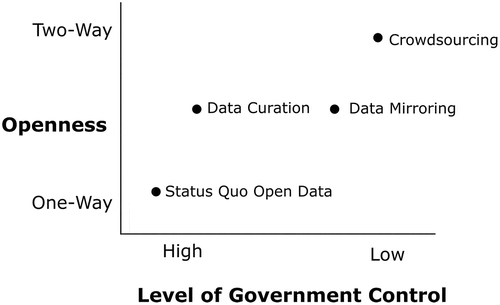
Despite the potential of direct editing of government geospatial data, the path to implementation encounters several challenges, both technical and organizational. Accompanying the implementation of a user-editing model is a shift in the locus of control of geospatial data creation and editing, moving from data providing government toward the data user. plots each of the four models described here on two axes: level of government control and relative “openness” for end users. The four models move from high levels of government control (status quo open data) to lower levels of government control (crowdsourcing). Level of “openness” is conceived of as the relative access of data to end users, ranging from “open” for download in the case of status quo open data, through various forms of editing control, to the participatory potential of the crowdsourcing model. From a government perspective, a loss of control over the complete data system can represent an opening up of a government to risks – risk of poor quality data contributions, risk of intentionally disruptive edits, even a risk of lack of use of an editing system that was expensive and time consuming to implement. Data curation, data mirroring, and crowdsourcing each aim to support the participation and collaboration aspects of open government, through opening up this channel for direct input. The government-focused safeguards of data curation and data mirroring make the adoption of these models more responsive to government concerns of loss of control. With each of these two models, government maintains direct control over the adoption of edits, with the ability to reject or follow-up on these edits before incorporation into a master database. With the crowdsourcing model, this data can again be vetted by government or by other users, but in this model, government is not privileged the same way as in the data curation and data mirroring models. Rather, government must abide by and respect the multiple ways that the community of users may edit or add to spatial data of a particular area. Crowdsourcing shows direct editing at its most divergent from current practices, what was once a data creation process defined by relatively complete government control over data gathering, storage, analysis, and primary sharing channels could be at least partially replaced by a crowdsourced data set created by a global community of at-times anonymous contributors to a project governed at a distance. Though an extreme case, this could represent divergent poles on a continuum of control over data creation and editing.
Figure 1. Four models of direct editing of government data.
New ways of using and interacting with government geospatial data are being created, with potential to bring together data created by government about citizens, with data created for government by citizens. This dynamic of data collection is thus framed as an ongoing conversation, providing a conduit to better connect citizens with one of the fundamental roles of government – data collection. This shift in control from government to citizen mirrors the general storyline of open government – where government aims to become more transparent, participatory, and collaborative (McDermott Citation2010). The presented models of direct editing of government data advance these three broad aims of open government via making government data available as open data (transparency), providing channels for citizen input and direct information sharing (participatory), and by opening up the data collection and editing work of government to others (collaborative). That this definition of open government is more diverse than simple access to data is critical – it is the processes, such as participation and collaboration that surround both data and citizen–government relationships, that can be considered as part of the open government movement (Meijer, Curtin, and Hillebrandt Citation2012).
5. The future of direct editing of government data
Should a government pursue direct data editing, the evolutionary models of data curation and data mirroring represent the most realistic near-term targets. These two models contrast with the crowdsourcing model in that government retains more control over access and acceptance of user edits. The mechanisms of control enforced by data curation and data mirroring provide government with checkpoints that can reduce risks of unwanted or erroneous data edits. It is possible to consider data curation and data mirroring as steps toward more extreme forms of direct editing, such as crowdsourcing. These two measures can be deployed to test both the user response to editing ability and also the government’s ability to accept and integrate edits. This type of staged implementation suggests that adoption of direct editing of data is a process that could unfold in an incremental fashion as a way to mediate government risk (or perception of risk) through a gradual roll-out of some of the data editing strategies described here.
Government data collection and mapping tasks are where land, space, and names are codified and attached to legal regulation, have potential to become enacted in real time, and as a potentially more participatory and transparent process. This does not necessarily mean that editing of government geospatial data will be improved from a technical standpoint, but rather that it could become an exercise in citizen engagement. This research sketches out four current and potential models of direct editing of government data. Open data serves as a starting point for not only the use of government data by third parties, but the opening up of government data collection and updating strategies to those same third parties. With this opening up, there are several models that can be potentially adopted or used, including the status quo of open data, data curation where government accepts feedback through a specifically developed system, mirroring, where government compares existing data with an externally generated crowdsourced data set, such as OSM, and lastly, the outright acceptance and integration of crowdsourced, third-party data sets within government applications and usage. There are several areas of constraints that could restrict the adoption of any or all of these models of citizen editing of government base geospatial data, centering on the issue of control of data creation and editing. To move on from a simple open data platform, governments must determine whether they are both able (from a legal requirement perspective, as custodians of public data) and willing (from an organizational culture and implementation perspective) to change or alter current operational procedures. Given a willingness to move forwards, key areas of necessary research follow-up include assessing the development and deployment of user-editing interfaces, an evaluation of the data received by government through any type of data curation, mirroring, or crowdsourcing approach, and a critical look at the trade-offs between edits or features made by a community of users, and the cost of alternate data editing models (both financial and other). It is this latter point that will bear a significantly closer look as the sustainability of any user-focused data editing strategy must rely on both the continued engagement of volunteers and continued support by government. To assess this sustainability, key metrics of value of the process of user-editing of data need to be developed, to better understand the changing directionality and nature of the feedback loop between data producer and consumer as ultimately it is the actualities of how government incorporates citizen contributions that will determine the future of these models. (Budhathoki, Bruce, and Nedovic-Budic Citation2008; Zuiderwijk and Janssen Citation2014).
Acknowledgments
I wish to thank Dr. Brent Hall and Jonathan Van Dusen from Esri Canada for conceptualizing and testing applications of the data curation model. Dr. Robert Feick from the University of Waterloo provided valuable comments on an early draft of this paper.
Disclosure statement
No potential conflict of interest was reported by the author.
Additional information
Funding
References
- Alexopoulos, C., E. Loukis, and Y. Charalabidis. 2014. “A Platform for Closing the Open Data Feedback Loop Based on Web2.0 Functionality.” eJournal of eDemocracy & Open Government 6 (1): 62–68. http://jedem.org/index.php/jedem/article/view/327
- Bartenberger, M., and V. Grubmüller. 2014. “The Enabling Effects of Open Government Data on Collaborative Governance in Smart City Contexts.” eJournal of eDemocracy & Open Government 6 (1): 36–48. doi:10.2139/ssrn.2474974.
- Bates, J. 2013. “The Domestication of Open Government Data Advocacy in the United Kingdom: A Neo-Gramscian Analysis.” Policy & Internet 5 (1): 118–137. doi:10.1002/poi3.25.
- Bates, J. 2014. “The Strategic Importance of Information Policy for the Contemporary Neoliberal State: The Case of Open Government Data in the United Kingdom.” Government Information Quarterly 31 (3): 388–395. doi:10.1016/j.giq.2014.02.009.
- Bearden, M. J. 2007. “The National Map Corps.” Workshop on Volunteered Geographic Information, Santa Barbara, University of California, December 13–14. http://www.ncgia.ucsb.edu/projects/vgi/docs/position/Bearden_paper.pdf.
- Bertot, J. C., P. McDermott, and T. Smith. 2012. “Measurement of Open Government: Metrics and Process.” In 2012 45th Hawaii International Conference on System Science (HICSS), 2491–2499. New York: IEEE. doi:10.1109/HICSS.2012.658.
- Bonina, C. M. 2013. “New Business Models and the Value of Open Data : Definitions, Challenges and Opportunities.” http://www.nemode.ac.uk/wp-content/uploads/2013/11/Bonina-Opendata-Report-FINAL.pdf
- Boulton, G., M. Rawlins, P. Vallance, and M. Walport. 2011. “Science as a Public Enterprise: The Case for Open Data.” The Lancet 377 (9778): 1633–1635. doi:10.1016/S0140-6736(11)60647-8.
- Brabham, D. C. 2009. “Crowdsourcing the Public Participation Process for Planning Projects.” Planning Theory 8 (3): 242–262. doi:10.1177/1473095209104824.
- Budhathoki, N. R., B. C. Bruce, and Z. Nedovic-Budic. 2008. “Reconceptualizing the Role of the User of Spatial Data Infrastructure.” GeoJournal 72 (3–4): 149–160. doi:10.1007/s10708-008-9189-x.
- Budhathoki, N. R., and C. Haythornthwaite. 2013. “Motivation for Open Collaboration: Crowd and Community Models and the Case of OpenStreetMap.” American Behavioral Scientist 57 (5): 548–575. doi:10.1177/0002764212469364.
- Burns, R. 2015. “Rethinking Big Data in Digital Humanitarianism: Practices, Epistemologies, and Social Relations.” GeoJournal 80 (4): 477–490. doi:10.1007/s10708-014-9599-x.
- Byron, I., and A. Curtis. 2002. “Maintaining Volunteer Commitment to Local Watershed Initiatives.” Environmental Management 30 (1): 59–67. doi:10.1007/s00267-002-2552-7.
- Carver, S., A. Evans, R. Kingston, and I. Turton. 2001. “Public Participation, GIS, and Cyberdemocracy: Evaluating on-Line Spatial Decision Support Systems.” Environment and Planning B: Planning and Design 28 (6): 907–921. doi:10.1068/b2751t.
- Charalabidis, Y., E. Loukis, and C. Alexopoulos. 2014. “Evaluating Second Generation Open Government Data Infrastructures Using Value Models.” In 2014 47th Hawaii International Conference on System Sciences, 2114–2126. New York: IEEE. doi:10.1109/HICSS.2014.267.
- Coleman, D. J. 2013. “Potential Contributions and Challenges of VGI for Conventional Topographic Base-Mapping Programs.” In Crowdsourcing Geographic Knowledge, edited by D. Sui, S. Elwood, and M. Goodchild, 245–263. Dordrecht: Springer Netherlands. http://www.springerlink.com/index/10.1007/978-94-007-4587-2_14.
- Connors, J. P., S. Lei, and M. Kelly. 2012. “Citizen Science in the Age of Neogeography: Utilizing Volunteered Geographic Information for Environmental Monitoring.” Annals of the Association of American Geographers 102 (6): 1267–1289. doi:10.1080/00045608.2011.627058.
- Conradie, P., and S. Choenni. 2014. “On the Barriers for Local Government Releasing Open Data.” Government Information Quarterly 31 (June): S10–S17. doi:10.1016/j.giq.2014.01.003.
- Cooper, A. K., S. Coetzee, I. Kaczmarek, D. G. Kourie, A. Iwaniak, and T. Kubik. 2011. “Challenges for quality in volunteered geographical information.” Paper presented at AfricaGeo 2011, Cape Town, May 31–June 2. http://www.africageodownloads.info/115_cooper_coetzee_kaczmarek.pdf.
- Crutcher, M., and M. Zook. 2009. “Placemarks and Waterlines: Racialized Cyberscapes in Post-Katrina Google Earth.” Geoforum 40 (4): 523–534. doi:10.1016/j.geoforum.2009.01.003.
- de Bruin, S., A. Bregt, and M. van de Ven. 2001. “Assessing Fitness for Use: The Expected Value of Spatial Data Sets.” International Journal of Geographical Information Science 15 (5): 457–471. doi:10.1080/13658810110053116.
- Devillers, R., Y. Bédard, R. Jeansoulin, and B. Moulin. 2007. “Towards Spatial Data Quality Information Analysis Tools for Experts Assessing the Fitness for Use of Spatial Data.” International Journal of Geographical Information Science 21 (3): 261–282. doi:10.1080/13658810600911879.
- Devillers, R., A. Stein, Y. Bédard, N. Chrisman, P. Fisher, and W. Shi. 2010. “Thirty Years of Research on Spatial Data Quality: Achievements, Failures, and Opportunities: Thirty Years of Research on Spatial Data Quality.” Transactions in GIS 14 (4): 387–400. doi:10.1111/j.1467-9671.2010.01212.x.
- Dodge, M., and R. Kitchin. 2013. “Crowdsourced Cartography: Mapping Experience and Knowledge“. Environment and Planning A 45 (1): 19–36. doi:10.1068/a44484.
- Elwood, S., M. F. Goodchild, and D. Sui. 2013. “Prospects for VGI Research and the Emerging Fourth Paradigm.” In Crowdsourcing Geographic Knowledge, edited by D. Sui, S. Elwood, and M. Goodchild, 361–375. Dordrecht: Springer Netherlands. http://www.springerlink.com/index/10.1007/978-94-007-4587-2_20.
- Feick, R., and S. Roche. 2013. “Understanding the Value of VGI.” In Crowdsourcing Geographic Knowledge, edited by D. Sui, S. Elwood, and M. Goodchild, 15–29. Dordrecht: Springer Netherlands. http://www.springerlink.com/index/10.1007/978-94-007-4587-2_2.
- Ghose, R., and W. E. Huxhold. 2001. “Role of Local Contextual Factors in Building Public Participation GIS: The Milwaukee Experience.” Cartography and Geographic Information Science 28 (3): 195–208. doi:10.1559/152304001782153017.
- Girres, J. F., anf G. Touya. 2010. “Quality Assessment of the French OpenStreetMap dataset“. Transactions in GIS 14 (4): 435–459. doi:10.1111/j.1467-9671.2010.01203.x.
- Goetz, M., and A. Zipf. 2013. “The Evolution of Geo-Crowdsourcing: Bringing Volunteered Geographic Information to the Third Dimension“. In Crowdsourcing Geographic Knowledge, edited by D. Sui, S. Elwood, and M. Goodchild, 139–159. Dordrecht: Springer Netherlands. doi:10.1007/978-94-007-4587-2_9.
- Goodchild, M. F. 2007. “Citizens as Sensors: The World of Volunteered Geography.” GeoJournal 69 (4): 211–221. doi:10.1007/s10708-007-9111-y.
- Goodchild, M. F., and L. Li. 2012. “Assuring the Quality of Volunteered Geographic Information.” Spatial Statistics 1: 110–120. doi:10.1016/j.spasta.2012.03.002.
- Haklay, M. 2010. “How Good Is Volunteered Geographical Information? A Comparative Study of OpenStreetMap and Ordnance Survey Datasets.” Environment and Planning B: Planning and Design 37 (4): 682–703. doi:10.1068/b35097.
- Haklay, M. 2013. “Citizen Science and Volunteered Geographic Information: Overview and Typology of Participation.” In Crowdsourcing Geographic Knowledge, edited by D. Sui, S. Elwood, and M. Goodchild, 105–122. Dordrecht: Springer Netherlands. http://www.springerlink.com/index/10.1007/978-94-007-4587-2_7.
- Haklay, M., V. Antoniou, S. Basiouka, R. Soden, and P. Mooney. 2014. “Crowdsourced Geographic Information Use in Government.” Report. London: Global Facility for Disaster Reduction & Recovery, World Bank. http://discovery.ucl.ac.uk/1433169/.
- Haklay, M., and P. Weber. 2008. “Openstreetmap: User-Generated Street Maps.” IEEE Pervasive Computing 7 (4): 12–18. doi:10.1109/MPRV.2008.80.
- Hartog, M., B. Mulder, B. Spée, E. Visser, and A. Gribnau. 2014. “Open Data within Governmental Organisations.” eJournal of eDemocracy & Open Government 6(1): 49–61. http://jedem.org/index.php/jedem/article/view/291
- Hecht, B., and D. Gergle. 2010. “The Tower of Babel Meets Web 2.0: User-Generated Content and Its Applications in a Multilingual Context.” In CHI ’10: 28th International Conference on Human Factors in Computing Systems, 291–300. New York: ACM. doi:10.1145/1753326.1753370.
- Janssen, M., Y. Charalabidis, and A. Zuiderwijk. 2012. “Benefits, Adoption Barriers and Myths of Open Data and Open Government.” Information Systems Management 29 (4): 258–268. doi:10.1080/10580530.2012.716740.
- Johnson, P. A., and P. Robinson. 2014. “Civic Hackathons: Innovation, Procurement, or Civic Engagement?: Civic Hackathon: Procurement or Civic Engagement?” Review of Policy Research 31 (4): 349–357. doi:10.1111/ropr.12074.
- Johnson, P. A., and R. E. Sieber. 2012. “Motivations Driving Government Adoption of the Geoweb.” GeoJournal 77 (5): 667–680. doi:10.1007/s10708-011-9416-8.
- Johnson, P. A., and R. E. Sieber. 2013. “Situating the Adoption of VGI by Government.” In Crowdsourcing Geographic Knowledge, edited by D. Sui, S. Elwood, and M. Goodchild, 65–81. Dordrecht: Springer Netherlands. http://www.springerlink.com/index/10.1007/978-94-007-4587-2_5.
- Judge, E. F., and T. Scassa. 2010. “Intellectual Property and the Licensing of Canadian Government Geospatial Data: An Examination of GeoConnections’ Recommendations for Best Practices and Template Licences: Intellectual Property and the Licensing of Canadian Government Geospatial Data.” Canadian Geographer/Le Géographe Canadien 54 (3): 366–374. doi:10.1111/j.1541-0064.2010.00308.x.
- Kingston, R., S. Carver, A. Evans, and I. Turton. 2000. “Web-Based Public Participation Geographical Information Systems: An Aid to Local Environmental Decision-Making.” Computers, Environment and Urban Systems 24 (2): 109–125. doi:10.1016/S0198-9715(99)00049-6.
- Kulk, S., and B. Van Loenen. 2012. “Brave New Open Data World?” International Journal of Spatial Data Infrastructures Research 7: 196–206. doi:10.2902/1725-0463.2012.07.art10.
- Lin, W. 2013. “When Web 2.0 Meets Public Participation GIS (PPGIS): VGI and Spaces of Participatory Mapping in China.” In Crowdsourcing Geographic Knowledge, edited by D. Sui, S. Elwood, and M. Goodchild, 83–103. Dordrecht: Springer Netherlands. http://www.springerlink.com/index/10.1007/978-94-007-4587-2_6.
- McDermott, P. 2010. “Building Open Government.” Government Information Quarterly 27 (4): 401–413. doi:10.1016/j.giq.2010.07.002.
- Meijer, A. J., D. Curtin, and M. Hillebrandt. 2012. “Open Government: Connecting Vision and Voice.” International Review of Administrative Sciences 78 (1): 10–29. doi:10.1177/0020852311429533.
- Offenhuber, D. 2015. “Infrastructure Legibility–a Comparative Analysis of open311-Based Citizen Feedback Systems.” Cambridge Journal of Regions, Economy and Society 8 (1): 93–112. doi:10.1093/cjres/rsu001.
- O’Reilly, T. 2011. “Government as a Platform.” Innovations: Technology, Governance, Globalization 6 (1): 13–40. doi:10.1162/INOV_a_00056.
- Rinner, C., and M. Bird. 2009. “Evaluating Community Engagement through Argumentation Maps—A Public Participation GIS Case Study.” Environment and Planning B: Planning and Design 36 (4): 588–601. doi:10.1068/b34084.
- Robinson, D., H. Yu, W. Zeller, and E. Felten. 2009. “Government Data and the Invisible Hand.” Yale Journal of Law & Technology 11: 160. http://yjolt.org/government-data-and-invisible-hand.
- Sæbø, Ø., J. Rose, and L. S. Flak. 2008. “The Shape of eParticipation: Characterizing an Emerging Research Area.” Government Information Quarterly 25 (3): 400–428. doi:10.1016/j.giq.2007.04.007.
- Saunders, A., T. Scassa, and T. P. Lauriault. 2012. “Legal Issues in Maps Built on Third Party Base Layers.” Geomatica 66 (4): 279–290. doi:10.5623/cig2012-054.
- Sieber, R. E., and P. A. Johnson. 2015. “Civic Open Data at a Crossroads: Dominant Models and Current Challenges.” Government Information Quarterly 32 (3): 308–315. doi:10.1016/j.giq.2015.05.003.
- Stephens, M. 2013. “Gender and the GeoWeb: Divisions in the Production of User-Generated Cartographic Information.” GeoJournal 78 (6): 981–996. doi:10.1007/s10708-013-9492-z.
- Sui, D., M. Goodchild, and S. Elwood. 2013. “Volunteered Geographic Information, the Exaflood, and the Growing Digital Divide.” In Crowdsourcing Geographic Knowledge, edited by D. Sui, S. Elwood, and M. Goodchild, 1–12. Dordrecht: Springer Netherlands. http://www.springerlink.com/index/10.1007/978-94-007-4587-2_1.
- Thatcher, J., L. Bergmann, B. Ricker, R. Rose-Redwood, D. O’Sullivan, T. J. Barnes, and L. R. Barnesmoore, et al. 2015. “Revisiting Critical GIS.” Environment and Planning A. doi:10.1177/0308518X15622208.
- Wolf, E. B., K. McNinch, and B. S. Poore. 2011. “OpenStreetMap Collaborative Prototype, Phase 1: U.S. Geological Survey Open-File Report 2011-1136.” Reston, VA: USGS. http://pubs.usgs.gov/of/2011/1136/pdf/OF11-1136.pdf
- Zook, M., M. Graham, T. Shelton, and S. Gorman. 2010. “Volunteered Geographic Information and Crowdsourcing Disaster Relief: A Case Study of the Haitian Earthquake.” World Medical & Health Policy 2 (2): 6–32. doi:10.2202/1948-4682.1069.
- Zuiderwijk, A., and M. Janssen. 2014. “Open Data Policies, Their Implementation and Impact: A Framework for Comparison.” Government Information Quarterly 31 (1): 17–29. doi:10.1016/j.giq.2013.04.003.