
ABSTRACT
The increased use of mobile maps in our highly mobile digital culture has resulted in a large variety of map users and map use situations. For mobile map applications that engage a broad user base and feature diverging map usage contexts, one-size-fits-all map interface designs might result in significant usability tradeoffs. To respond to this challenge, changing the map design based on map use context attributes, such as increasing icon sizes for people with impaired vision or using the user’s position to highlight information on the map are only a few of the many ways mobile map applications can be designed and adapted to respond to the needs of users and their map use situations. However, there remains a clear need for research on the intersections between map use contexts and mobile map application design and adaptation. Therefore, this article reviews and synthesizes literature on map use context research and design adaptation of mobile map applications. To push forward efforts in these areas, we propose future research themes and approaches. We first evaluate options for modeling map use context, which plays a significant part in map adaptations for detecting relevant context attributes on which to base adaptation decisions. We then consider dynamic possibilities to assess the usability of these adaptations by reviewing the HEART framework. We conclude by offering ways to move the suggested approaches from concepts closer to practice.
1. Introduction
Ideally, map applications should be easily usable by all of their potential map users and for all of their intended map use situations. The design of the application should consequently aim for a positive experience by meeting the requirements emerging from these map use situations (Roth et al., Citation2017). The design is, therefore, crucial to ensure the usability and utility of the application and should correspond to established human-computer interaction (HCI) principles (Newman et al., Citation2010). To determine and implement an adequate design, Roth et al. (Citation2017) indicate that a user-centered design (UCD) helps to identify the map user, map use situation, and their respective design requirements.
However, especially in a highly mobile digital society, map users and their map use situations will be rather diverse in, for example, user characteristics or map use environments, or environments can change rapidly. This is also acknowledged by Griffin, Robinson et al. (Citation2017), mentioning as their fourth “crosscutting theme” for future cartographic research the fact that diversity plays an important role in defining, among others, users, use cases, and visualizations of maps. Creating inclusive cartographic designs, which consider “accessibility, disability, literacy, and other individual user differences” is another relevant aspect for designing and adjusting maps (Roth & International Cartographic Association, Citation2019, p. 2). Griffin et al. (Citation2017) also emphasize the importance of considering individual differences between map use context for the design, adjustment, and transferability of maps. In response to that, Newman et al. (Citation2010) suggest to clearly identify and distinguish users so as to adequately present and build the required features.
In practice, map applications are usually designed in a way that is adequate for most map users and typical map use situations (i.e. map use contexts). A usability tradeoff may be accepted, which means that the design is not necessarily satisfactory for all users or all contexts. Meng and Malczewski (Citation2009) and Gottwald et al. (Citation2016) argue that if map users encounter usability problems with the map, the frustration level of these users increases and, with this, users’ motivation to continue using the mapping tool decreases. The potential for map applications to alienate portions of its intended user base threatens the ability of these tools to adequately support decision-making processes and, in general, map use activities (Gottwald et al., Citation2016). This is particularly true for applications that have a very broad utility and usability in a variety of map use contexts (i.e. users and situations of map use).
To account for these differences in map use context, and to overcome this tradeoff, the map application design could adapt to the requirements of individual differences in map use context. With the term map design adaptation, we refer to either the map users being able to adjust the map based on their preferences (i.e. adaptable map design) or the map itself controls and initiates the adaptation (i.e. adaptive map design). Both adaptation behaviors aim to support the users in their map use activities and, therefore, depend on the map use context. Hence, we must assess the map use context as it is a significant aspect to consider when creating and adjusting the design of mobile map applications.
In the early 2000s, some research was conducted on assessing map use context for the design and adaptation of mobile maps (e.g. Reichenbacher (Citation2003) or Sarjakoski and Nivala (Citation2005)). Since then, besides research on Location-Based Services (LBS) (Huang et al., Citation2018), map use context and mobile map design adaptations have not gained much traction in the cartographic community. However, in recent years, the concept of map design transferability has reawakened attention for considering map use context in cartographic design (Griffin, White et al., Citation2017; Roth et al., Citation2017).
This article builds on past research to consider map use context for the design of mobile map applications, and recently renewed interest as a result of the significant increase of mobile map use in a highly mobile society. The objective of this article is to review how to overcome map design usability challenges by adapting their design to the different users and map use situations by considering map use context. This review article particularly intends to investigate the following aspects:
The role of map use context for the design of mobile map applications.
Concepts of how mobile map application designs adapt to the map use.
Potential future research themes in the field of context-based design adaptations of mobile map applications.
To address these aspects, we review and synthesize themes from recent literature in cartography and its collaborative linkages in other fields. We begin by describing the relevance of map use context for the map application design and then continue reviewing how map use context can be used for adaptations in mobile map applications. We further highlight two possible future research themes for moving forward in the field of map application adaptation. For this, we first review approaches on how to model map use context. We then examine the relevance of dynamic usability evaluations for monitoring map design adaptations. In the final section, we conclude with a call for action for continuing research on these topics.
2. Map use context and its role for the mobile map application design
Map use context can have a significant impact on the (perceived) usability of a map application. For example, (color-)vision-deficient users may be significantly challenged with inadequate color choices, icon display sizes, or font types in maps, especially in low-light situations; and digitally low-literate users may be challenged with a range of interface functionalities that overburden them cognitively. Hence, not only do the attributes of the map use context impact map design usability, but also the differing background, training, needs, and use objectives of the map users, as well as their map use situations. The constantly growing number of mobile devices, and hence mobile map use, extends the classic map use contexts and gives rise to further challenges, such as screen size and interactivity limitations, distractors in the environment, parallel tasks, time pressure, etc. This is also acknowledged within the field of LBS, where services should not only be adapted to users’ location, but also to other relevant contextual factors, such as their environment, the time of the day, their interest, and tasks, etc. (context-aware LBS from a technical perspective is reviewed by Huang et al. (Citation2018)).
In computer science, context is defined, in the most general terms, as information that characterizes the situation of a user (Dey & Abowd, Citation1999; Schilit et al., Citation1994). Most of the reviewed literature categorize map use context in terms of information about the activity and task (or purpose of use), physical environment (location, weather), temporal situation (time, season), experiences, preferences and aversions, culture, and system/technology (display size, transfer rate) (see e.g. Reichenbacher (Citation2004), Sarjakoski and Nivala (Citation2005), and Griffin et al. (Citation2017)). While some of the human background factors (i.e. gender and age) received attention in many map use studies, others are less frequently the focus of map use research, including, for example, vision constraints or the level of map reading skills, etc. (Griffin, White et al., Citation2017).
Sagl et al. (Citation2015) distinguish external and internal context, whereby external context refers to physical/environmental information, and internal context refers to human cognitive (internal) factors. Ballatore et al. (Citation2010) propose various context layers, including sensor layers, semantic layers (i.e. map features and POIs), and process layers (i.e. assigning user-interest scores to each map feature). Zhang et al. (Citation2009) propose different factors to capture context, i.e. through physical sensors (e.g. location sensors, GNSS), virtual sensors (e.g. scheduled activities from the users’ calendar), and logical sensors (i.e. combining information from the physical and virtual sensors, e.g. whether scheduled activities can be attended on time based on the users’ location).
Generally, two types of context acquisition can be distinguished: implicit and explicit context acquisition (Zhang et al., Citation2009). Explicit context refers to the map user explicitly selecting interface or map design preferences (e.g. changing the map extent or changing the interface language, etc.). In contrast, implicit context is derived from a users’ behavior on the map or the behavior during map use (e.g. mouse or gaze movement, users’ location or speed of movement, etc.) (Ballatore & Bertolotto, Citation2015). Here, the user does not have to explicitly input any information for the context definition. While the explicit context information provided by a map user (i.e. the user purposely changes map or interface preferences) considers mostly static, or non-frequently changing information, implicit context acquisition is dynamic, as temporal or environmental factors may frequently change (Mac Aoidh et al., Citation2009).
In the following, we summarize some of the predominantly discussed map use context attributes, and how one may adapt the map application design to them accordingly:
2.1. User activity and tasks
Sarjakoski and Nivala (Citation2005) emphasize the importance of adapting the map to its specific purpose of use. For the case of outdoor mobile map applications, the authors illustrate that while orienteers require detailed topographic information, a family out hiking is more likely to require information about campsites and the primary walking tracks. As landmarks play a critical role in wayfinding, choosing which to show on the map (i.e. local landmarks only seen along the route, or global landmarks visible from everywhere) and where to position them (i.e. at or between route decision points) (Schwering et al., Citation2017) will also depend on the context of navigation (Credé et al., Citation2019a, Citation2019b). Hence, the activity or purpose of use plays a vital role in adjusting the content of the base map or activity-adapted points of interest (POIs), including landmarks. Dransch (Citation2005) emphasizes the importance of specific map use tasks for certain user activities. For example, navigation activities require map use tasks, such as identifying departure and destination locations, identifying locational map symbols, or planning a route. These tasks can be differentiated by their level of complexity, and they can be guided through task-related map adaptations. Additionally, Elias et al. (Citation2005) differentiate navigation purposes and respective route characteristics, including the shortest, fastest, most touristic, most scenic, or the easiest route. For navigation and wayfinding, contextual factors such as wayfinder’s cultural background, individual spatial abilities, mobility preferences, environmental conditions, etc. can influence route choice. In the context of map assisted-wayfinding, the map type (i.e. augmented reality display or 2D cartographic map) and map design (i.e. realistic 3D landmarks or 2D landmarks) can impact wayfinding, and spatial knowledge acquisition (Cheng, Ruginski, Fabrikant et al., Citation2021; Cheng, Ruginski, Wunderlich et al., Citation2021; Freksa, Citation1999; Kapaj et al., Citation2021).
2.2. Physical environment
The most commonly discussed physical or environmental factors are the location, weather conditions, or illuminance (Sarjakoski & Nivala, Citation2005). In response to visibility constraints based on the light conditions, the interface should react to a dark environment (Zhang et al., Citation2009) differently compared to bright sunlight (Schilling et al., Citation2005) by for example, adjusting the label size or map symbol colors (Sarjakoski & Nivala, Citation2005). Weather conditions may also impact navigation (Sarjakoski & Nivala, Citation2005), for example, in terms of selecting an appropriate route. Apart from location and weather conditions, distractions triggered by noise level or by highly populated environments (e.g. sport events, crowded city centers, etc.) can temporarily constrain the cognitive capability of the user.
2.3. Temporal situation
As Elias et al. (Citation2005) state, navigation purposes are influenced by temporal and situational factors of the user, such as their mode of movement, e.g. by car, bike, or on foot, and the time of the day/season (e.g. rush hour, holidays, visual restrictions at night, road conditions during winter). In terms of temporal conditions, Raubal and Panov (Citation2009) and Weninger (Citation2012) suggest adapting the map symbology and display icons to the time of the day or the season. Information regarding the speed of movement may indicate the mode of transportation (Liang et al., Citation2010). The movement type can also be used to define the map extent (Raubal & Panov, Citation2009) and influences its information density and map symbology (Reichenbacher, Citation2005). The speed of movement influences the change of contextual information, for example, regarding services that are only available in certain locations (Dransch, Citation2005; Reichenbacher, Citation2005). The speed of movement further impacts time constraints. Higher speed of movement may require faster decision-making, creating time pressure for accessing information quickly and tailored to the immediate need (Meng, Citation2005).
2.4. Experience, spatial and cognitive abilities
Atzmanstorfer et al. (Citation2016) mention that users with less experience in smartphone use may be less familiar with applications other than social media. Dunn (Citation2007), Aditya (Citation2010), Gottwald et al. (Citation2016), and Eitzinger et al. (Citation2019) further reveal that such users are challenged when using mobile map applications. Bartling et al. (Citation2019) found that users with less experience in smartphone use and interactive maps were struggling to identify their own location when zooming in and out of the map because the level of detail shown on the base map changed. With this change of base map information, some users were challenged to re-orient themselves on the map. Thrash et al. (Citation2019) delineate how users’ expertise and emotional response impact task performance, spatial learning, and user experience. In terms of cognitive abilities and information processing, Berendt et al. (Citation1998, p. 313) describe how analyzing the structure of maps gives clues about how map users “perceive, represent, and interact with their spatial environment.” The same authors further describe their aspect map approach. They argue that the information visualized on the map is a selection of aspects to represent geographic entities and that how users cognitively process these aspects depends on the task and type of visualization. Cognitive abilities have also been discussed in literature on navigational tasks and wayfinding. Schwering et al. (Citation2017), for example, reviewed how users acquire route knowledge and route memory through turn-by-turn navigational support, whereas users acquire survey knowledge through the support of orientation wayfinding.
2.5. Preferences and aversions
The map content should correspond to the preferences or aversions of the users (Petit et al., Citation2007). Past map use activities should be documented and evaluated to understand preferences. This information may reveal the users’ interests in certain information or locations and can be responded to through, e.g. POI-recommendations on the map (Liang et al., Citation2010; McArdle et al., Citation2010).
2.6. Culture and identity
Weninger (Citation2012), Yingjie et al. (Citation2001), Slocum et al. (Citation2001), and Nivala and Sarjakoski (Citation2007) reveal that color schemes and icon symbolizations are subject to different cultural associations. Even though icon representations are often pre-defined and commonly used (such as those found in Google’s Material Design or Ionic Icons), these may not represent local or cultural conventions. These differences must also be considered for the language, and for reflecting the cultural and social conventions of a place (Atzmanstorfer et al., Citation2016; Slocum et al., Citation2001).
These contextual attributes and their influence on potential mobile map design adaptations are some of the predominantly discussed map use contexts found in the reviewed literature. The list should serve as an overview of how different map applications can be designed depending on the specific needs of different map use contexts. Further, map use context serves as a basis for map application adaptations and adaptive systems that dynamically adjust the map application to changes in map use context. In the next section, we review concepts of context-based adaptations for mobile maps.
3. Context-based mobile map design adaptation
Adapting interfaces to computers, systems, or applications to different user needs and preferences has a long tradition in the field of HCI (Miraz et al., Citation2021). Regarding the objective for adapting a user interface, Sanderson and Treu (Citation1993, p. 245) find that “[…], depending on the needs of a particular user to whom the interface is to adapt, the adaptation behavior should be facilitative, such as by enabling the user to complete tasks more quickly or with less knowledge and effort.”
In general, two types of adaptive behavior can be distinguished (Chou et al., Citation2018): adaptability and adaptivity. The key distinctive features are the initiative and control over the adaptation. Adaptable systems allow users to change parts of the system themselves, e.g. by selecting profiles or by making interactive changes. Adaptive systems perform these steps automatically. Both of these adaptive behaviors require a system that is non-static and allows adaptation. Dieterich et al. (Citation1993) proposed a framework for allocating the user and the system to four phases of the adaptation process: initiative for adaptation, proposal of changes, decision upon action, and execution of change. We refer to adaptability when all four steps are allocated to the user, and adaptivity when all four steps are allocated to the system.
Hence, an adaptive map application can become useful if the number of user interactions to change the interface becomes too large and/or too complex to perform manually by the users of map applications. Also, as stated above, an adaptive approach should be considered if the user group is known to lack the required knowledge and skills or when users are too distracted by temporal circumstances to perform the adaptation by themselves or to customize the interface according to their preferences.
For map applications, it must be determined which domain should be the object of adaptation. The three different domains that can be adapted are the data or content domain, the visual representation and map symbolization, and the map interface (Reichenbacher, Citation2004). All three domains can be adapted toward a target (i.e. map use context). In addition, it is also important to consider where (locality) and at what level (granularity) changes should be made to the interface (Sanderson & Treu, Citation1993) of map applications. A further decision is whether changes should be made globally (e.g. general color settings) or only affect a specific element of the interface (e.g. disabling a particular map function).
Another important issue is the timing of the adaptation. An adaptation can be triggered by differences (e.g. user characteristics) or changes (e.g. daytime) (Alatalo & Peräaho, Citation2001). In addition, adaptation can be accomplished before use and/or during use (Dieterich et al., Citation1993). Differences in static map use context (e.g. eye constraints or age) could be an example of a trigger for adaptation before use.
Adaptation of interfaces can enable or disable functions or settings, switching between pre-selected settings, reconfiguring previously set parameters, or unconstrained editing of all system functionality and elements of an interface (Cockton (Citation1987), as cited in Rouillard (Citation2010)). Depending on what part of the interface is affected, adaptation is manifested on the logical or on the physical level (Dieterich et al., Citation1993). In the literature, these are also often referred to as the semantic, syntactic, and lexical levels according to the three levels of interaction in an interface (e.g. Stephanidis et al. (Citation2012), Paramythis et al. (Citation2010)). The semantic level is responsible for conveying the meaning of an interface element to the user, e.g. the underlying function of a button. The syntactic level deals with the structure of interactions, e.g. the interdependence of a set of buttons. The lexical level concerns the explicit form an interaction would take, e.g. the visual appearance of a button.
The degree of adaptation depends on the available information about the user and their context. The more (detailed) information is available about the map use context, whether it be explicit or implicit, the more specifically a map application can potentially be adapted. However, adaptation is a spectrum, and several researchers have proposed mixed-initiative adaptations, i.e. combinations of automated system-initiated changes and user- initiated changes.
Adaptive user interfaces have been widely studied since the 1990s (Browne et al., Citation1990; Brusilovsky, Citation1996; Dieterich et al., Citation1993; Fischer, Citation2001; Oppermann, Citation1994; Schneider-Hufschmidt et al., Citation1993), mainly with the dominance of the WIMP (windows–icons–menus–pointer) paradigm in HCI. More recently, this field has regained attention from a broader research community. Reasons for this revival of adaptive interfaces (though in different variations, e.g. “responsive design,” “personalized interface”) may be the diversity of devices and platforms (web, tablets, smartphones, etc.), the increasing complexity of systems, and the advances in technology, i.e. automation, Artificial Intelligence (AI), abundance of logged data, etc. Another reason is that map applications, and collaborative and participatory initiatives have become mainstream. Therefore, the user base has grown and become more diverse. Similarly, map use contexts have increased through the ubiquitous use of mobile map applications, and with this, the map use context has become more dynamic. Dynamic attributes of map use context, such as temporal and environmental context factors, can subsequently lead to the need for dynamic adaptations of the application.
However, a challenge of the dependence on (dynamic) map use context in adaptive systems is linked to the problem of privacy. Adaptivity relies on detailed information about the map use context to effectively adapt the application. Such information can be logged interactions, user observation, location data, or other sensitive data and immediately affects the privacy of users. However, without revealing some information and exhibiting at least some degree of trust, adaptive behavior cannot be implemented. A key challenge for any adaptive system is thus the handling of the information used for adaptivity and the way the process is communicated to the user in a trustworthy manner. Yet, tradeoffs will always remain, such as those between usability, automation, control, consistency, and privacy.
Subsequently, if adaptivity is not well implemented, too intrusive, or its mechanisms not transparent and comprehensible for the user, it can be counterproductive. Automatic and dynamic changes and adaptive behavior can conflict with the principle of consistency in HCI. Moreover, automation always comes with a loss of control, which is a major challenge of adaptive systems (Browne et al., Citation1990). Most users are reluctant to give up full control to a system and prefer to have full control or to at least stay in the loop (Kiefer et al., Citation2017).
4. Future research themes for context-based adaptations of mobile map applications
In the previous sections, we reviewed and synthesized recent literature on how the map use context is relevant for the design of mobile map applications to create suitable maps that are responsive and adaptive. We now continue by highlighting two significant challenges for research on context-based adaptations of map applications.
Firstly, the evaluation and definition of context attributes that are relevant for adaptation and the interplay between different context attributes, in particular when numerous context attributes are collected, is a challenge, and has limited coverage in the literature. In concurrence with Huang et al. (Citation2018) and Thrash et al. (Citation2019), we argue that it is important to understand whether age, educational background, or the emotional state of users play a role for the map adaptation and whether their relevance for adaptation differs in its interplay with, e.g. the general application purpose, the task a user wants to carry out, or environmental conditions. Griffin et al. (Citation2017) mention the issue of evaluating and defining relevant context attributes and formulate this problem as an open research question. In their study, they suggest that map designers define relevant context attributes by identifying similarities and differences between users in their context. Evaluating these similarities and differences in dynamic adaptive systems requires the processing of potentially large datasets with numerous context attributes. We, therefore, argue that we need to find ways to model map use context in a way that enables these similarities and differences to be detected more automatically.
Secondly, given the challenges related to the implementation of map application adaptations to respond to map use context, it is essential to evaluate these adaptations by monitoring their success and adequateness (Reichenbacher, Citation2004; Thrash et al., Citation2019). Adaptations can be implemented in the map application in numerous ways, e.g. by responding to different types of map use context (e.g. map use activities, physical environment, etc.), with different levels and degrees of adaptation, on different domains, and in a static or dynamic manner. Particularly dynamic contextual factors, such as temporal or environmental context attributes, are typically included in extensive and detailed map use context datasets. These types of map use context data can facilitate dynamic context-based adaptations in map applications to respond to frequently changing map use context attributes (Huang et al., Citation2018; Thrash et al., Citation2019). However, the challenge here is that traditional UCD practices to evaluate usability might not be suitable to assess these dynamic changes in map design adaptations in relation to map use context and usability.
Therefore, besides the challenge of modeling map use context data, we see another challenge in dynamically assessing the usability of map design adaptations. Within both challenges, we propose two future research themes. In the following sections, we will characterize these major themes, proposals, and call for action for future work.
4.1 Future research theme 1: modeling map use context
In the literature, different ways have been outlined, compared, and evaluated to model context data for interface adaptations. Grifoni et al. (Citation2018) and Mokbel et al. (Citation2011) consider personalization and recommendation as the two main adaptation strategies. Examples of methods to create user profiles for personalization and recommendation are explained in Petit et al. (Citation2007), Richter et al. (Citation2010), Mac Aoidh et al. (Citation2009), and Grifoni et al. (Citation2018) review techniques for recommender systems and categorize them into content-based filtering and collaborative filtering. The content-based filtering method takes into account past actions and focusses on the characteristics of a particular content or interface element that a user liked and content or elements with similar characteristics will be recommended in the future (McArdle et al., Citation2012). In collaborative filtering, the focus lies on detecting similarities between users’ preferences, where items that have been liked by other users with similar preferences will be recommended in the future (Hannula et al., Citation2019). Collaborative filtering can be implemented using memory-based or model-based methods (Su & Khoshgoftaar, Citation2009). Especially model-based methods are preferable for big data applications as memory-based methods have scalability and sparsity issues (RaviKanth et al., Citation2021). Model-based methods comprise machine learning-based techniques such as clustering and dimensionality reduction (Su & Khoshgoftaar, Citation2009). However, methods such as Principal Component Analysis (as a dimensionality reduction technique) or k-means (as a clustering technique) suffer from various limitations (Mørup & Hansen, Citation2012). Principal Component Analysis leads to complex representations of the dataset that are difficult to interpret. While clustering algorithms simplify the interpretation of the dataset by assigning each data point to a defined cluster, they lack the ability to describe data points that also have relationships to other clusters, e.g. data points on the edges of clusters (Mørup & Hansen, Citation2012). To overcome the hurdles of these methods, archetypal analysis provides highly interpretable representations and the possibility to cluster data points (Cabero & Epifanio, Citation2019). It has been successfully applied to various use cases for collaborative filtering such as the Netflix price (Mørup & Hansen, Citation2012), matching footwear size (Alcacer et al., Citation2021), and game recommendations (Sifa et al., Citation2014).
With archetypal analysis, the goal is to represent the dataset by calculating distinct archetypes and identify explicit descriptors for these archetypes (Cutler & Breiman, Citation1994; Mørup & Hansen, Citation2012; Seth & Eugster, Citation2016). Data points of a dataset can then be described as an observation on a spectrum between these archetypes (i.e. a blend of archetypes), where a data point is represented by each archetype to a varying degree. While archetypal analysis has been applied as a technique for collaborative filtering, Bartling et al. (Citation2021) applied archetypal analysis to a dataset on map use context and usability evaluation for generating map design profiles suitable to their map users, which provides an approach toward content-based filtering.
Hence, while archetypal analysis has received little attention as a technique for content-based filtering, we propose this method to be an interesting additional method to consider. Archetypal analysis might be particularly useful for the approach outlined by Griffin et al. (Citation2017) since similarities and differences between users can be detected and described with the use of the spectrum between archetypes (constituting a core advantage over other context modeling methods). In practice and for map design adaptations specifically, archetypal representations of the context dataset can be used to approximate the adaptation needs of users in their map use situations (e.g. by designing map design profiles for each archetype as outlined in Bartling et al. (Citation2021)), but, if necessary, the adaptation can also respond to stronger individual contextual differences (depending on the users’ position on the spectrum, i.e. mixtures of archetypes).
To simplify and describe the approach, we assume an archetypal representation of a context dataset with three calculated archetypes and explicit descriptors, where archetype 1 (A1) constitutes a map user sitting on a bus, archetype 2 (A2) a map user standing outside on the street, and archetype 3 (A3) a map user at home. In this example, users on the bus (A1) or street (A2) are usually surrounded by a fluctuating environment, which is why time availability can be constrained or distractions can be high. By contrast, users sitting at home (A3) are most likely surrounded by few other persons, which creates a calmer and less distracting atmosphere. To respond to the needs of each user in their map use situation, the adjustment of the map design may occur on the map content, map content representation, or map elements of the interface. For the bus scenario (A1), the contrast and size of the symbology might be increased. The content could be filtered and grouped into layers to accommodate larger icons and fonts. For the street scenario (A2), the user might need a reduced range or simplified set of functionalities and modes of interactivity. The user could benefit from a reduced level of detail of the content and a prioritization of information to highlight user interest. For the home scenario (A3), the interface could respond with a full range of functionalities and modes of interactivity and detailed geographic features and symbologies. When it comes to users that are represented by a mixture of archetypes, it would be possible that only specific elements are adapted. For example, a user sitting in a coffee shop could be represented by a mixture of archetypes A1 and A3, since context attributes of this user may range between these two archetypes. While the user in the coffee shop is not impacted by environmental factors (e.g. rain or direct sunlight) and has no time constraints, the user might be distracted by the surrounding people in the coffee shop. Hence, the application might respond by slightly reducing the functionalities and filtering the information on the map to support the user.
The implementation of archetypal analysis for map adaptation in practice depends on the definition of archetypes, acquisition, quantity, quality, and variance of these context dimensions, and on the dataset and defined thresholds for the map adaptation. Archetypal analysis can be done with an already acquired dataset or on the fly in the moment of context information acquisition. Thus, archetypes can be re-calculated frequently, depending on the growth of the dataset. The archetypal approach enables the application to dynamically include new context data of users into the dataset and represent them as a composition of the pre-defined archetypes whenever there is a change in map use context. Subsequently, the application can dynamically respond to this change in context data with a suitable map application adaptation.
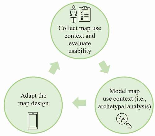
A possible workflow for dynamic map adaptation (see ) could be that a map application is used and data from the users and their context is collected by the application. Traditional UCD practices and dynamic usability metrics (see sub-section 4.2) are necessary to evaluate the usability of the map application design and its components regarding the map use context. Based on the collected user context dataset, archetypes are calculated and related to the results of the usability evaluations. In a subsequent step, decisions on how the adaptation of the map interface should look can be derived for each archetype and/or mixture of archetypes. From here on, the map adaptation can be iteratively adjusted and refined by continuously and dynamically evaluating the usability, re-creating archetypes if necessary, and adjusting the design decisions of the map adaptation.
Figure 1. Iterative workflow for combining map use context modeling, usability evaluation, and dynamic, context-based map design adaptations.
4.2 Future research theme 2: dynamically evaluating map adaptation usability
As dynamically changing context attributes play a significant role in map adaptation, the question arises how to improve the process of evaluating the impact of context on the map adaptation to conduct proper needs assessments for map design decisions. Common UCD practices to evaluate usability, such as heuristic evaluations, questionnaires, cognitive walkthroughs, or field and lab studies (Poppe et al., Citation2007), and the creation of scenarios to test specific design elements, are useful. As Avouris et al. (Citation2008) indicate, these scenarios may test and focus on aspects such as the locations and settings (environmental and temporal factors), movement and posture, workloads, distractions and activities, devices and usage, users and personas. However, these traditional evaluation methods may struggle to represent the complex and dynamically changing circumstances that are found in real map use context data, and in some cases, evaluations that can characterize dynamic changes are time and resource consuming to conduct (e.g. eye-tracking). As we deal with dynamically changing context and map interface settings, we also need to find ways to respond to these changes with suitable and adaptation-tailored usability evaluation methods and metrics.
Assessing large-scale datasets (that are typically acquired through contextual data) provides the possibility to apply metrics for understanding user behavior. Big data analytics help to compare these metrics between similar users (e.g. of similar archetypal representations) to generate meaningful interpretations of the metrics. Rodden et al. (Citation2010) suggest the HEART framework (Happiness, Engagement, Adoption, Retention, and Task success), where traditional usability metrics (happiness and task success) are coupled with the engagement, adoption, and retention of the users when interacting with the application. Logging data to evaluate these metrics is less intrusive to the user and can be continuously measured during the user interaction with the map application. This is demonstrated in a study by Savino et al. (Citation2021), who tracked users’ interaction with the Google Maps application, and by commercial systems like Maptiks. Logging interactional and behavioral data might, therefore, provide candidates for tailoring usability metrics to assess the dynamic adaptation process. Interaction logging is by no means new (Hilbert & Redmiles, Citation2000), but viewing interaction logs through a lens such as the HEART framework suggests a departure from looking at individual mouse movements or clicks. Instead, we might focus more broadly on the extent to which users are adopting a platform and returning to use it regularly and emphasize evaluation techniques that can characterize evidence of user satisfaction and general forms of engagement. This stands in contrast to the more traditional use of interaction logs to explicitly measure time and task success and to focus on those measurements at the level of individual users.
For adaptive map applications, we see two strategies to apply such a framework. Firstly, usability metrics could be generated for the overall use of the application as an overarching evaluation of the entire adaptation process. We suggest focusing on happiness (user satisfaction), and retention (long-term active users) as these are relevant factors for the use of mapping applications. In contrast, the evaluation of the task success and user engagement might depend on specific tasks and activities (which we will mention in later paragraphs of this section). For these specific tasks and activities, the satisfaction of the users is also relevant. Simplified and short ratings that pop up throughout their use of the application might be helpful in these cases. However, a high quantity of surveys and ratings to obtain users’ opinions about the specifics of the adaptation might burden the users. Finding better metrics or effective proxies to assess user satisfaction would be useful in this case. Otherwise, traditional usability evaluations (e.g. focus groups to evaluate users’ satisfaction) could be included into the workflow of applying the framework, while relying on interaction logs for other assessments (e.g. retention or engagement).
To assess the adaptation process more specifically, dissecting each adaptation and finding suitable metrics to track the usability is the second step in the evaluation of map adaptations. As the adaptation of map interfaces should assist the users in their specific needs, the metrics might look completely different between different map use contexts based on what kind of interface “works” for each user. For example, a possible objective for some map applications that are used outdoors might not be that a user spends as much time as possible interacting with the application. Rather, the application might be designed in a way that a user can accomplish the tasks as fast as possible. Hence, a higher number of clicks or a long time and in-depth engagement with the application might not equal a positive usability in all map use situations.
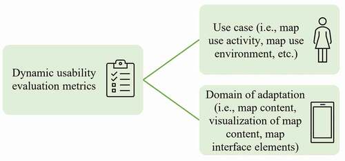
To choose which usability metrics are suitable to evaluate the adaptation, two dependencies are of potential interest (see ): the use case, and the domain of adaptation (i.e. content, visualization, and interface elements).
Figure 2. Dependencies for designing dynamic usability evaluation metrics.
4.2.1 Map evaluation depending on the use case
As seen in the example above, the use case might determine the activity a user wants to accomplish. For example, the map application for a user sitting at home (with fewer distractions and more time available) might offer a broader range of functionalities (e.g. managing additional geographic layers, reviewing or adding detailed geographic information, e.g. lines and polygons in addition to point features) and detailed geographic features and symbologies. A user would potentially need to engage with such an information-rich interface for a longer time period, and in a more in-depth manner. Hence, more in-depth engagement with the interface might yield improved usability. In contrast, the map application may adapt to a user in a car or on the street by highlighting relevant geographic features on the map (e.g. street network, gas stations), contrasting the symbology to increase the readability of these features, and reducing the complexity of interaction (e.g. panning/zooming, searching for features). Therefore, in the case of a user in a distracting environment, the shorter the time spent engaging with the map application, the better the adaptation in its support for the map use context. With these two use cases, we exemplify how diverse the usability evaluation of map adaptations can and should be. For some use cases and activities, less engagement might equal a better usability.
4.2.2 Map evaluation depending on the domain of adaptation (content, visualization, and interface elements)
The selection of a suitable evaluation method may not only depend on the map use situation (i.e. use cases) but also on the specific adaptation of objects in the map application. For the elements of the interface, we assume that map feature adoption and retention rates might be suitable indicators for understanding which specific elements of the map are actually used and returned to by the users on a long-term basis. For example, geographic information might be stored in additional feature layers. Yet, when users are not pressing the layer toggle button at all or only occasionally, the map adaptation might need to be revised. Also, the frequent use of the search bar to filter or search for map features could potentially indicate that the content presentation or pre-filter of the content of the map adaptation is not suitable as the users have to search for the desired content and information (e.g. when browsing for specific locations or POIs). The use of specific elements can also be evaluated by the task success. However, this metric might be difficult to assess since it might not always be clear what exactly the user wants to achieve when using interface elements. For example, users might be moving (zooming and panning) on the map to familiarize themselves with the geographic area or explore the surroundings of a location without actually pursuing a specific task. In terms of the content and its visualization, when the readability of the symbology (e.g. feature size and shape, contrast and color scale of the symbology) is reduced (e.g. in illuminated situations on sunny days), the user might need to spend more time on the map and retrieve additional map information to clarify the meaning of the content. A more in-depth engagement would not be desired in this case.
Overall, we assume that the retention rate of using the map application for specific use situations might give further clues about the usefulness of the adaptation for these circumstances. The overall diversity of map use situations might also be useful to assess the versatility of the map application adaptation. In general, we see the potential to invest future research in continuing to develop dynamic assessment methods for context-aware map applications as this will be relevant for the success of map adaptations. Future research on this might also be complemented with metrics on cognitive aspects and spatial and adaptive learning (Huang et al., Citation2018; Schwering et al., Citation2017; Thrash et al., Citation2019). In contrast to traditional performance metrics (i.e. the task success metric within the HEART framework), increased spatial cognition and spatial decision-making potentially enhance users’ awareness of their environment (and therefore of their context) (Schwering et al., Citation2017; Thrash et al., Citation2019). The evaluation of the map design adaptation, therefore, could also depend on these kinds of cognitive aspects and could complement and extend the described metrics of the HEART framework.
5. Conclusions
In this paper, we aimed to review research on map use context and design adaptation of mobile map applications and build on recent trends on map design transferability. We further introduced and proposed two main future research themes as a call for action for continuing research on context-based mobile map design adaptation and transferability. In particular for mobile map applications that engage a broad user base and feature diverging map use contexts, a one-size-fits-all interface design may lead to tradeoffs in usability. In the literature, many usability constraints concerning the diversity of map users and map use situations are mentioned, and the call for more research on the intersections between map use contexts and map application design is evident. Map personalization and context-based map adaptations are potential ways to adjust designs of mobile map applications to diverse map use contexts.
Changing the map design to specific map use context attributes, such as increasing the icon sizes for people with impaired vision, using the user’s location and interest to filter or emphasize content, and adapting the color scheme to cultural conventions are some of the many ways in which map applications can adapt to the users. Several previous studies have evaluated specific map use context attributes for the usability of map applications. Yet, there is currently little research that analyzes the interplay between a broader range of map use contexts, the dynamic nature of the tasks they are attempting to complete, dynamic context attributes such as environmental conditions, modes of movement, or levels of distraction, and the assessment of relevant context attributes.
The conceptualization and implementation of context-based adaptations in mobile map applications will benefit from research on the interplay of these diverse context attributes, their influence on the adaptation, and the evaluation of relevant map use context attributes. These context-based adaptations may differ in how they look depending on their implementation. Whether the map application is adaptable or adaptive, whether the adaptation will take place before or during use, and when, where, and what should adapt can vary and depends on the conceptualization of the adaptation. Implementing context-based adaptations depends on the purpose of the application, the user audiences with their context attributes, available resources to implement adaptations, and other factors. However, there is currently a lack of guidelines and recommendations, and little research that evaluates the implementation of map application adaptations, not only regarding the adaptation architecture, but also regarding privacy, and usability concerns.
This article was guided by several research aspects to evaluate the relevance of map use context for the map design, and to inspect ways on how to implement map use context-based map adaptations. Furthermore, we identified two major challenges regarding map use context modeling and the evaluation of map application adaptations and proposed two future research themes based on these challenges. While our intention was not to provide a comprehensive research agenda, we aimed to provide two potential solutions to two identified research gaps and challenges.
First, we examined ways to model map use context that can be used for the adaptation of mobile map applications and proposed the use of archetypal analysis as an interesting addition to commonly used context modeling techniques. We see this approach as one that flexibly and dynamically includes and responds to the context attributes of application users by representing the map use context data through archetypes and mixtures of archetypes. We call for the evaluation of archetypal analysis to describe map adaptation and studies that target the spectrum between archetypes. In practice, dealing with users who exhibit mixtures of archetypes will pose challenges in terms of how map designs can be adapted. When a user and their map use context is placed on the edge between two or more archetypes, individual map application elements (e.g. symbology, range of functionalities, etc.) could be adjusted based on rules, depending on the specific composition of each mixture of archetypes.
As a second future research theme, we identified that for long-term and large-scale usability evaluations, logging metrics and characterizing them in aggregated form, through, e.g. the HEART framework, might be useful to continuously monitor and dynamically evaluate the usability to understand the suitability of map design decisions in context-based map adaptations. Developing and comparing suitable and dynamic ways to track and evaluate the quality and success of map adaptations is an area of significant potential for future research. Further development of dynamic metrics to monitor map design adaptation, leveraging empirical evidence from spatial cognition research, provides opportunities to complement traditional user interface/user experience performance metrics with relevant insights from spatial cognition research, including adaptive learning.
While we reviewed both potential future research themes through the lens of examples, both of the proposed methods have been reviewed and applied to use cases in other domains (see examples on archetypal analysis in Seth and Eugster (Citation2016) and Bauckhage and Thurau (Citation2009), and on the HEART framework in Lachner et al. (Citation2017)). We, therefore, see potential to apply, test, and validate the proposed methods with datasets on map use context from actual measurements.
In addition to the reviewed concepts in this article, adaptive learning and context-based learning in gaming research, where, for example, the difficulty level depends on the users’ abilities (see, for example, the stealth assessment aspect outlined in Shute and Ventura (Citation2013)), might also provide insights with potential to be reviewed and translated to context-based adaptations in the cartographic domain. It would, therefore, be interesting to systematically review context and its implementation in other domains, such as in gaming and cognition research, adaptive learning, as well as data science. We limited our review on spatial cognition (see the corresponding paragraph in Section 2) and adaptation strategies (see Section 4.1) only to a few aspects and methods, which could be extended in subsequent studies. To conclude, suitable and useful solutions have yet to be found to carry the proposed concepts to the stage of being used in practice and on a large-scale to deal with dynamic context-based adaptations of mobile map applications. However, it is essential to rise to the challenge of finding suitable and practical solutions if we are to develop effective design workflows to ensure that map applications can be truly adaptive to their intended users in a variety of real-world map use contexts.
Acknowledgments
We would like to thank the anonymous reviewers for their helpful comments and suggestions.
Disclosure statement
No potential conflict of interest was reported by the author(s).
Additional information
Funding
References
- Aditya, T. (2010). Usability issues in applying participatory mapping for neighborhood infrastructure planning. Transactions in GIS, 14(3), 119–147. https://doi.org/https://doi.org/10.1111/j.1467-9671.2010.01206.x
- Alatalo, T., & Peräaho, J. (2001). A modelling method for designing adaptive hypermedia. In 8th International Conference on User Modeling (UM2001)-Third Workshop on Adaptive Hypertext and Hypermedia, Sonthofen, Germany. Symposium conducted at the meeting of Citeseer.
- Alcacer, A., Epifanio, I., Valero, J., & Ballester, A. (2021). Combining classification and user-based collaborative filtering for matching footwear size. Mathematics, 9(7), 771. https://doi.org/https://doi.org/10.3390/math9070771
- Atzmanstorfer, K., Eitzinger, A., Marin, B. E., Parra Arteaga, A., Gonzalez Quintero, B., & Resl, R. (2016). HCI-Evaluation of the GeoCitizen-reporting App for citizen participation in spatial planning and community management among members of marginalized communities in Cali, Colombia. GI_Forum, 1(1), 117–132. https://doi.org/https://doi.org/10.1553/giscience2016_01_s117
- Avouris, N., Fiotakis, G., & Raptis, D. (2008). On measuring usability of mobile applications. In Proceedings of the International Workshop on Meaningful Measures: Valid Useful User Experience Measurement, Reykjavik, Iceland. Toulouse, France: Institute of Research in Informatics of Toulouse (IRIT).
- Ballatore, A., & Bertolotto, M. (2015). Personalizing maps. Communications of the ACM, 58(12), 68–74. https://doi.org/https://doi.org/10.1145/2756546
- Ballatore, A., McArdle, G., Kelly, C., & Bertolotto, M. (2010). Recomap. In S. Y. Shin (Ed.), Proceedings of the 2010 ACM Symposium on Applied Computing (p. 887). ACM. https://doi.org/https://doi.org/10.1145/1774088.1774273
- Bartling, M., Havas, C. R., Wegenkittl, S., Reichenbacher, T., & Resch, B. (2021). Modeling patterns in map use contexts and mobile map design usability. ISPRS International Journal of Geo-Information, 10(8), 8. https://doi.org/https://doi.org/10.3390/ijgi10080527
- Bartling, M., Resch, B., Eitzinger, A., & Zurita-Arthos, L. (2019). A multi-national human‐computer interaction evaluation of the public participatory GIS GeoCitizen. GI_Forum 2019, 7(1), 19–39. https://doi.org/https://doi.org/10.1553/giscience2019_01_s19
- Bauckhage, C., & Thurau, C. (2009). Making archetypal analysis practical. In J. Denzler, G. Notni, and H. Süße (Eds.), Lecture Notes in Computer Science: Vol. 5748, Pattern recognition: 31st DAGM symposium, Jena, Germany, September 9- 11,2009; proceedings (pp. 272–281). Springer.
- Berendt, B., Barkowsky, T., Freksa, C., & Kelter, S. (1998). Spatial representation with aspect maps. In C. Freksa, C. Habel, & K. F. Wender (Eds.), Lecture Notes in Computer Science: Vol. 1404. Spatial Cognition: An Interdisciplinary Approach to Representing and Processing Spatial Knowledge (pp. 313–336). Springer. https://doi.org/https://doi.org/10.1007/3-540-69342-4_15
- Browne, D., Totterdell, P., & Norman, M. (1990). Adaptive user interfaces. Computers and people series. Academic Press, Harcourt Brace Jovanovich Publishers.
- Brusilovsky, P. (1996). Methods and techniques of adaptive hypermedia. User Modeling and User-Adapted Interaction, 6(2–3), 87–129. https://doi.org/https://doi.org/10.1007/BF00143964
- Cabero, I., & Epifanio, I. (2019). Archetypal analysis: An alternative to clustering for unsupervised texture segmentation. Image Analysis & Stereology, 38(2), 151–160. https://doi.org/https://doi.org/10.5566/ias.2052
- Cheng, B., Ruginski, I. T., & Fabrikant, S. I. (2021). Enhancing spatial learning during navigation by optimizing landmark density on digital maps. In S. Bartušēvica, L. Zariņa, and J. Šķilters (Chair) (Eds.), Book of abstracts (pp. 28-29). University of Latvia.
- Cheng, B., Ruginski, I. T., Wunderlich, A., Gramann, K., & Fabrikant, S. I. (2021). Effect of cognitive load on spatial learning during navigation: A virtual reality study. In International Neuroergonomics Conference 2021, Ludwig-Maximilians-Universität Fakultät für Mathematik, Informatik und Statistik, Munich, Germany.
- Chou, C.-Y., Lai, K. R., Chao, P.-Y., Tseng, S.-F., & Liao, T.-Y. (2018). A negotiation-based adaptive learning system for regulating help-seeking behaviors. Computers & Education, 126, 115–128. https://doi.org/https://doi.org/10.1016/j.compedu.2018.07.010
- Cockton, G. (1987). Some critical remarks on abstractions for adaptable dialogue managers. In D. Diaper, and R. Winder (Eds.), British Computer Society workshop series. People and computers III: proceedings of the Third Conference of the British Computer Society, Human-Computer Interaction Specialist Group (pp. 323–344). University of Exeter, UK, Cambridge University Press.
- Credé, S., Thrash, T., Hölscher, C., & Fabrikant, S. I. (2019a). The acquisition of survey knowledge for local and global landmark configurations under time pressure. Spatial Cognition & Computation, 19(3), 190–219. https://doi.org/https://doi.org/10.1080/13875868.2019.1569016
- Credé, S., Thrash, T., Hölscher, C., & Fabrikant, S. I. (2019b). The advantage of globally visible landmarks for spatial learning. Journal of Environmental Psychology, 67, 101369. https://doi.org/https://doi.org/10.1016/j.jenvp.2019.101369
- Cutler, A., & Breiman, L. (1994). Archetypal analysis. Technometrics, 36(4), 338–347. https://doi.org/https://doi.org/10.1080/00401706.1994.10485840
- Dey, A. K., & Abowd, G. D. (1999). Towards a better understanding of context and context-awareness. In HUC ’99: Proceedings of the1st international symposium on Handheld and Ubiquitous Computing (pp. 304–307). Springer-Verlag. ftp://ftp.cc.gatech.edu/pub/gvu/tr/1999/99-22.pdf
- Dieterich, H., Malinowski, U., Kühme, T., & Schneider-Hufschmidt, M. (1993). State of the art in adaptive user interfaces. Human Factors in Information Technology, 10, 13.
- Dransch, D. (2005). Activity and context — A conceptual framework for mobile geoservices. In L. Meng, T. Reichenbacher, & A. Zipf (Eds.), Map-based mobile services: Theories, methods and implementations (pp. 31–42). Springer-Verlag Berlin Heidelberg. https://doi.org/https://doi.org/10.1007/3-540-26982-7_3
- Dunn, C. E. (2007). Participatory GIS — A people’s GIS? Progress in Human Geography, 31(5), 616–637. https://doi.org/https://doi.org/10.1177/0309132507081493
- Eitzinger, A., Cock, J., Atzmanstorfer, K., Binder, C. R., Läderach, P., Bonilla-Findji, O., Bartling, M., Mwongera, C., Zurita, L., & Jarvis, A. (2019). GeoFarmer: A monitoring and feedback system for agricultural development projects. Computers and Electronics in Agriculture, 158, 109–121. https://doi.org/https://doi.org/10.1016/j.compag.2019.01.049
- Elias, B., Hampe, M., & Sester, M. (2005). Adaptive visualisation of landmarks using an MRDB. In L. Meng, T. Reichenbacher, & A. Zipf (Eds.), Map-based mobile services: Theories, methods and implementations (pp. 73–86). Springer-Verlag Berlin Heidelberg. https://doi.org/https://doi.org/10.1007/3-540-26982-7_6
- Fischer, G. (2001). User modeling in human‐computer interaction. User Modeling and User-Adapted Interaction, 11(1–2), 65–86. https://doi.org/https://doi.org/10.1023/A:1011145532042
- Freksa, C. (1999). Spatial aspects of task-specific wayfinding maps. Visual and Spatial Reasoning in Design, 15–32. https://www.semanticscholar.org/paper/SPATIAL-ASPECTS-OF-TASK-SPECIFIC-WAYFINDING-MAPS-A-Freksa/f5cdddc87931555f9a23c8a8c213296188e5067e
- Gottwald, S., Laatikainen, T. E., & Kyttä, M. (2016). Exploring the usability of PPGIS among older adults: Challenges and opportunities. International Journal of Geographical Information Science, 30(12), 2321–2338. https://doi.org/https://doi.org/10.1080/13658816.2016.1170837
- Griffin, A. L., Robinson, A. C., & Roth, R. E. (2017). Envisioning the future of cartographic research. International Journal of Cartography, 3(sup1), 1–8. https://doi.org/https://doi.org/10.1080/23729333.2017.1316466
- Griffin, A. L., White, T., Fish, C., Tomio, B., Huang, H., Sluter, C. R., Bravo, J. V. M., Fabrikant, S. I., Bleisch, S., Yamada, M., & Picanço, P. (2017). Designing across map use contexts: A research agenda. International Journal of Cartography, 3(sup1), 90–114. https://doi.org/https://doi.org/10.1080/23729333.2017.1315988
- Grifoni, P., D’Ulizia, A., & Ferri, F. (2018). Context-Awareness in location based services in the big data era. In G. Mastorakis, C. X. Mavromoustakis, C. Dobre, E. Pallis, & G. Skourletopoulos (Eds.), SpringerLink Bücher: Vol. 10. Mobile Big Data: A Roadmap from Models to Technologies (Vol. 10, pp. 85–127). Springer. https://doi.org/https://doi.org/10.1007/978-3-319-67925-9_5
- Hannula, R., Nikkilä, A., & Stefanidis, K. (2019). GameRecs: Video Games Group Recommendations. In European Conference on Advances in Databases and Information Systems. Bled, Slovenia: Symposium conducted at the meeting of Springer.
- Hilbert, D. M., & Redmiles, D. F. (2000). Extracting usability information from user interface events. ACM Computing Surveys (CSUR), 32(4), 384–421. https://doi.org/https://doi.org/10.1145/371578.371593
- Huang, H., Gartner, G., Krisp, J. M., Raubal, M., & van de Weghe, N. (2018). Location based services: Ongoing evolution and research agenda. Journal of Location Based Services, 12(2), 63–93. https://doi.org/https://doi.org/10.1080/17489725.2018.1508763
- Kapaj, A., Lanini-Maggi, S., & Fabrikant, S. I. (2021). The impact of landmark visualization style on expert wayfinder’s cognitive load during navigation. In International Cartographic Conference. Symposium conducted at the meeting of International Cartographic Association, Florence, Italy.
- Kiefer, P., Giannopoulos, I., Athanasios Anagnostopoulos, V., Schöning, J., & Raubal, M. (2017). Controllability matters: The user experience of adaptive maps. Geoinformatica: An International Journal on Advances of Computer Science for Geographic Information Systems, 21(2017), 619–641. https://doi.org/http://dx.doi.org/10.1007/s10707-016-0282-x
- Lachner, F., Fincke, F., & Butz, A. (2017). Ux metrics: Deriving country-specific usage patterns of a website plug-in from web analytics. In R. Bernhaupt, G. Dalvi, A. Joshi, D. K. Balkrishan, J. O’Neill, and M. Winckler (Eds.), Lecture Notes in Computer Science: Vol. 10515, Human-computer interaction - INTERACT 2016: 16th IFIP TC 13 International Conference, Mumbai, India, September 25-29, 2017: Proceedings (pp. 142–159). Springer.
- Liang, Z., Kesorn, K., & Poslad, S. (2010). The USHER system to generate semantic personalised maps for travellers. In M. Wallace, I. E. Anagnostopoulos, M. Bielikova, & P. Mylonas (Eds.), Studies in computational intelligence: Vol. 279. Semantics in adaptive and personalized services: Methods, tools and applications (Vol. 279, pp. 49–71). Springer-Verlag Berlin Heidelberg. https://doi.org/https://doi.org/10.1007/978-3-642-11684-1_4
- Mac Aoidh, E., McArdle, G., Petit, M., Ray, C., Bertolotto, M., Claramunt, C., & Wilson, D. (2009). Personalization in adaptive and interactive GIS. Annals of GIS, 15(1), 23–33. https://doi.org/https://doi.org/10.1080/00207720903270985
- McArdle, G., Ballatore, A., Tahir, A., & Bertolotto, M. (2010). An open-source web architecture for adaptive location based services. The International Archives of the Photogrammetry, Remote Sensing and Spatial Information Sciences, 38(2), 296–301.
- McArdle, G., Petit, M., Ray, C., & Claramunt, C. (2012). Recommendations based on region and spatial profiles. In S. Di Martino (Ed.), Lecture Notes in Computer Science Ser: v.7236. Web and Wireless Geographical Information Systems: 11th International Symposium, W2GIS 2012, Naples, Italy, April 12-13, 2012, Proceedings (Vol. 7236, pp. 167–184). Naples, Italy: Springer Berlin/Heidelberg. https://doi.org/https://doi.org/10.1007/978-3-642-29247-7_13
- Meng, L., & Malczewski, J. (2009). Web-PPGIS usability and public engagement: A case study in Canmore, Alberta, Canada. CyberGeo: European Journal of Geography, Advance online publication. https://doi.org/https://doi.org/10.4000/cybergeo.22849
- Meng, L. (2005). Ego centres of mobile users and egocentric map design. In L. Meng, T. Reichenbacher, & A. Zipf (Eds.), Map-based mobile services: Theories, methods and implementations (pp. 87–105). Springer-Verlag Berlin Heidelberg. https://doi.org/https://doi.org/10.1007/3-540-26982-7_7
- Miraz, M. H., Ali, M., & Excell, P. S. (2021). Adaptive user interfaces and universal usability through plasticity of user interface design. Computer Science Review, 40, 100363. https://doi.org/https://doi.org/10.1016/j.cosrev.2021.100363
- Mokbel, M. F., Bao, J., Eldawy, A., Levandoski, J. J., & Sarwat, M. (2011). Personalization, socialization, and recommendations in location-based services 2.0. 5th International Workshop on Personalized Access, Profile Management, and Context Awareness in Databases, PersDB. Seattle, Washington, USA. http://www.cs.ucr.edu/~eldawy/publications/persdb11a.pdf
- Mørup, M., & Hansen, L. K. (2012). Archetypal analysis for machine learning and data mining. Neurocomputing, 80, 54–63. https://doi.org/https://doi.org/10.1016/j.neucom.2011.06.033
- Newman, G., Zimmerman, D., Crall, A., Laituri, M., Graham, J., & Stapel, L. (2010). User-friendly web mapping: Lessons from a citizen science website. International Journal of Geographical Information Science, 24(12), 1851–1869. https://doi.org/https://doi.org/10.1080/13658816.2010.490532
- Nivala, A.-M., & Sarjakoski, T. L. (2007). User aspects of adaptive visualization for mobile maps. Cartography and Geographic Information Science, 34(4), 275–284. https://doi.org/https://doi.org/10.1559/152304007782382954
- Oppermann, R. (Ed.). (1994). Adaptive user support: Ergonomic design of manually and automatically adaptable software. CRC Press.
- Paramythis, A., Weibelzahl, S., & Masthoff, J. (2010). Layered evaluation of interactive adaptive systems: Framework and formative methods. User Modeling and User-Adapted Interaction, 20(5), 383–453. https://doi.org/https://doi.org/10.1007/s11257-010-9082-4
- Petit, M., Ray, C., & Claramunt, C. (2007). A user context approach for adaptive and distributed GIS. In S. I. Fabrikant & M. Wachowicz (Eds.), Lecture notes in geoinformation and cartography. The European information society: Leading the way with geo-information (Vol. 43, pp. 121–133). Springer-Verlag Berlin Heidelberg. https://doi.org/https://doi.org/10.1007/978-3-540-72385-1_7
- Poppe, R., Rienks, R., & van Dijk, B. (2007). Evaluating the future of HCI: Challenges for the evaluation of emerging applications. In T. S. Huang, A. Nijholt, M. Pantic, and A. Pentland (Eds.), Lecture Notes in Computer Science: Vol. 4451. Artificial intelligence for human computing: ICMI 2006 and IJCAI 2007 international workshops, Banff, Canada, November 3, 2006 and Hyderabad, India, January 6, 2007 (Vol. 4451, pp. 234–250). Springer. https://doi.org/https://doi.org/10.1007/978-3-540-72348-6_12
- Raubal, M., & Panov, I. (2009). A formal model for mobile map adaptation. In W. Cartwright, G. Gartner, L. Meng, M. P. Peterson, & K. Rehrl (Eds.), Lecture notes in geoinformation and cartography. Location based services and telecartography II: From sensor fusion to context models (Vol. 58, pp. 11–34). Springer Berlin Heidelberg. https://doi.org/https://doi.org/10.1007/978-3-540-87393-8_2
- RaviKanth, K., ChandraShekar, K., Sreekanth, K., & Kumar, P. S. (2021). Recommendation system for e-commerce by memory based and model based collaborative filtering. In A. Abraham, M. A. Jabbar, S. Tiwari, and I. M. S. Jesus (Eds.), Springer eBook Collection: Vol. 1182. Proceedings of the 11th International Conference on Soft Computing and Pattern Recognition (SoCPaR 2019) (1st ed., Vol. 1182, pp. 123–129). Hyderabad, India: Springer International Publishing; Imprint Springer. https://doi.org/https://doi.org/10.1007/978-3-030-49345-5_13
- Reichenbacher, T. (2003). Adaptive methods for mobile cartography. In The International Cartographic Association (Chair), Proceedings of the 21st International Cartographic Conference (ICC): Cartographic Renaissance, Durban, South Africa: International Cartographic Association.
- Reichenbacher, T. (2004). Mobile cartography: Adaptive visualisation of geographic information on mobile devices. Zugl.: München, Techn. Univ., Diss., 2004 (1. Aufl.). Geowissenschaften. Verl. Dr. Hut. https://mediatum.ub.tum.de/doc/601066/file.pdf
- Reichenbacher, T. (2005). Adaptive egocentric maps for mobile users. In L. Meng (Ed.), Map-based mobile services: Theories, methods and implementations (pp. 141–158). Springer. https://doi.org/https://doi.org/10.1007/3-540-26982-7_10
- Richter, K.-F., Dara-Abrams, D., & Raubal, M. (2010). Navigating and learning with location based services: A user-centric design. In G. Gartner, and Y. Li (Chairs), eds. Proceedings of the 7th International Symposium on LBS & TeleCartography (LBS2010) Guangzhou, China.
- Rodden, K., Hutchinson, H., & Fu, X. (2010). Measuring the user experience on a large scale: User-Centered metrics for web applications. In Proceedings of CHI 2010 Atlanta, Georgia: Association for Computing Machinery, New York. http://www.rodden.org/kerry/heart-metrics-chi2010.pdf
- Roth, R. E., Çöltekin, A., Delazari, L., Filho, H. F., Griffin, A., Hall, A., Korpi, J., Lokka, I., Mendonça, A., Ooms, K., & van Elzakker, C. P. J. M. (2017). User studies in cartography: Opportunities for empirical research on interactive maps and visualizations. International Journal of Cartography, 3(sup1), 61–89. https://doi.org/https://doi.org/10.1080/23729333.2017.1288534
- Roth, R. (2019). What is mobile first cartographic design? In International Cartographic Association (Ed.), ICA joint workshop on user experience design for mobile cartography. Bern, Switzerland: International Cartographic Association.
- Rouillard, J. (2010). Plastic interfaces for ubiquitous learning. In T. T. Goh (Ed.), Multiplatform e-learning systems and technologies: Mobile devices for ubiquitous ICT-based education (pp. 128–146). Information Science Reference. https://doi.org/https://doi.org/10.4018/978-1-60566-703-4.ch008
- Sagl, G., Resch, B., & Blaschke, T. (2015). Contextual sensing: Integrating contextual information with human and technical geo-sensor information for smart cities. Sensors (Basel, Switzerland), 15(7), 17013–17035. https://doi.org/https://doi.org/10.3390/s150717013
- Sanderson, D. P., & Treu, S. (1993). Adaptive user interface design and its dependence on structure. Human Factors in Information Technology, 10, 241.
- Sarjakoski, L. T., & Nivala, A.-M. (2005). Adaptation to context — A way to improve the usability of mobile maps. In L. Meng, T. Reichenbacher, & A. Zipf (Eds.), Map-based mobile services: Theories, methods and implementations (pp. 107–123). Springer-Verlag Berlin Heidelberg. https://doi.org/https://doi.org/10.1007/3-540-26982-7_8
- Savino, G.-L., Sturdee, M., Rundé, S., Lohmeier, C., Hecht, B., Prandi, C., Nunes, N. J., & Schöning, J. (2021). MapRecorder: Analysing real-world usage of mobile map applications. Behaviour & Information Technology, 40(7), 646–662. https://doi.org/https://doi.org/10.1080/0144929X.2020.1714733
- Schilit, B., Adams, N., & Want, R. (1994). Context-aware computing applications. In Workshop on Mobile Computing Systems 1994 (pp. 85–90). Santa Cruz, CA, USA: IEEE. https://doi.org/https://doi.org/10.1109/MCSA.1994.512740
- Schilling, A., Coors, V., & Laakso, K. (2005). Dynamic 3D maps for mobile tourism applications. In L. Meng, T. Reichenbacher, & A. Zipf (Eds.), Map-based mobile services: Theories, methods and implementations (pp. 227–239). Springer-Verlag Berlin Heidelberg. https://doi.org/https://doi.org/10.1007/3-540-26982-7_15
- Schneider-Hufschmidt, M., Kühme, T., Malinowski, U., and Hufschmidt, M. S. (Eds.). (1993). Human factors in information technology: Vol. 10. Adaptive user interfaces: Principles and practice. North Holland. http://www.loc.gov/catdir/enhancements/fy0601/93008442-d.html
- Schwering, A., Krukar, J., Li, R., Anacta, V. J., & Fuest, S. (2017). Wayfinding Through Orientation. Spatial Cognition & Computation, 17(4), 273–303. https://doi.org/https://doi.org/10.1080/13875868.2017.1322597
- Seth, S., & Eugster, M. J. A. (2016). Probabilistic archetypal analysis. Machine Learning, 102(1), 85–113. https://doi.org/https://doi.org/10.1007/s10994-015-5498-8
- Shute, V., & Ventura, M. (2013). Measuring and Supporting Learning in Games: Stealth Assessment. The MIT Press. https://doi.org/https://doi.org/10.7551/mitpress/9589.001.0001
- Sifa, R., Bauckhage, C., & Drachen, A. (2014). Archetypal game recommender systems. In T. Seidl, M. Hassani, C. Beecks (Eds.), Proceedings of the LWA 2014 Workshops: KDML, IR, FGWM (pp. 45-56). Aachen, Germany, 8-10 September 2014.
- Slocum, T. A., Blok, C., Jiang, B., Koussoulakou, A., Montello, D. R., Fuhrmann, S., & Hedley, N. R. (2001). Cognitive and usability issues in geovisualization. Cartography and Geographic Information Science, 28(1), 61–75. https://doi.org/https://doi.org/10.1559/152304001782173998
- Stephanidis, C., Antona, M., Savidis, A., Partarakis, N., Doulgeraki, K., & Leonidis, A. (2012). Design for all: Computer-Assisted design of user interface adaptation. In G. Salvendy (Ed.), Handbook of human factors and ergonomics (4th ed., pp. 1484–1507). John Wiley & Sons. https://doi.org/https://doi.org/10.1002/9781118131350.ch54.
- Su, X., & Khoshgoftaar, T. M. (2009). A survey of collaborative filtering techniques. Advances in Artificial Intelligence, 2009, 1–19. Article ID 421425. https://doi.org/https://doi.org/10.1155/2009/421425
- Thrash, T., Lanini-Maggi, S., Fabrikant, S. I., Bertel, S., Brügger, A., Credé, S., Do, C. T., Gartner, G., Huang, H., Münzer, S., & Richter, K.-F. (Eds.) (2019). The Future of Geographic Information Displays from GIScience, Cartographic, and Cognitive Science Perspectives (Vision Paper). Schloss Dagstuhl - Leibniz-Zentrum fuer Informatik GmbH, Wadern/Saarbruecken, Germany.
- Weninger, B. (2012). Deducing parameters for personalizing maps from map interaction patterns. In C. Duarte, L. Carriço, J. Jorge, S. Oviatt, and D. Gonçalves (Eds.), Iui ‘12: Proceedings of the 17th International Conference on Intelligent User Interfaces, February 14-17, 2012, Lisbon, Portugal; [including workshop papers (p. 341). Lisbon, Portugal: ACM. https://doi.org/https://doi.org/10.1145/2166966.2167044
- Yingjie, W., Yue, L., Xiaogang, C., Yufen, C., & Meng, L. (2001). Adaptive geovisualization: An approach towards the design of intelligent geovisualization systems. Journal of Geographical Sciences, 11(S1), 1–8. https://doi.org/https://doi.org/10.1007/BF02837439
- Zhang, D., Adipat, B., & Mowafi, Y. (2009). User-Centered context-aware mobile applications―The next generation of personal mobile computing. Communications of the Association for Information Systems, 24(1). Article 3, 28–46 . https://doi.org/https://doi.org/10.17705/1CAIS.02403