
ABSTRACT
The response of the Greenland Ice Sheet to future climate change is relatively unconstrained. Determining the extents and rates of ice-margin fluctuations during the Holocene provides a longer-term perspective on ice-sheet changes and offers an analogue of how the ice-sheet may respond to future changes. Here, we present sixteen new 10Be ages of boulders on moraines, boulders perched on bedrock, and bedrock surfaces that mark the timing of ice-margin fluctuations during the Holocene in the Kangerlussuaq region of southern west Greenland. We show that the Keglen moraines date to 8.0 ± 0.3 ka (n = 6) and that the average ice-margin retreat rate slowed from about 49 to 13 m yr−1 after about 8.0 ka, likely in response to the ice margin retreating onto land at the head of the fjord Kangerlussuaq at this time. The average retreat rate further slowed to less than 1 m yr−1 between 6.8 ka and 4.2 cal kyr BP, a time when nearby paleoclimate records document warm summers and increased precipitation. Finally, we show that the historical advances of the ice margin occurred during the past 200 years, likely in response to cooler summer temperatures.
KEYWORDS:
Introduction
Global sea level is predicted to rise 0.5–1.2 m (Stocker et al. Citation2013) by the end of the twenty-first century and contributions from the Greenland Ice Sheet (GrIS) are projected to be 8–22 cm by AD 2100 (Bindschadler et al. Citation2013). Determining the extents and rates of GrIS margin fluctuations during the Holocene, including warmer-than-present times such as the Holocene Thermal Maximum (HTM, 8–5 ka; Briner et al. Citation2016; Dahl-Jensen et al. Citation1998; Kaufman et al. Citation2004), provides a longer-term record of how the ice-sheet responds to climate conditions and may refine predictions of how the ice sheet will respond to future climate changes (e.g., Briner et al. Citation2010; Carlson et al. Citation2014; Kelley, Briner, and Zimmerman Citation2015; Larsen et al. Citation2014; Levy et al. Citation2012; Rinterknecht et al. Citation2009; Winsor et al. Citation2015; Young et al. Citation2011). Here, we present sixteen new 10Be ages of boulders on moraines, boulders perched on bedrock, and bedrock surfaces that constrain the Holocene extents and thicknesses of the western GrIS margin fluctuations near Kangerlussuaq, Greenland. Based on these ages, we calculate early to middle Holocene ice-margin retreat rates and compare them to nearby paleoclimate records to evaluate the possible mechanisms that influenced ice-margin fluctuations throughout the Holocene.
Field setting and prior work
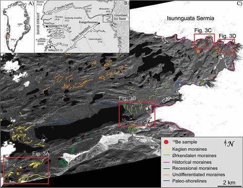
The Kangerlussuaq region of southern west Greenland hosts an exceptional record of Holocene GrIS extents in the form of north-south trending moraines (). These well-preserved moraines exist from the coast near Sisimiut to the present-day ice margin, and mark stillstands or readvances of the ice-sheet margin (Ten Brink Citation1975; Ten Brink and Weidick, Citation1974; van Tatenhove, van der Meer, and Koster Citation1996). The ages of many of these moraines have been previously constrained using minimum and maximum radiocarbon ages (Ten Brink Citation1975; van Tatenhove, van der Meer, and Koster Citation1996). More recently, some have been dated directly using 10Be dating (Carlson et al. Citation2014; Levy et al. Citation2012; Rinterknecht et al. Citation2009; Winsor et al. Citation2015). In this article, we focus on the region between Kangerlussuaq and the present-day ice margin where three moraine systems occur: the Keglen, Ørkendalen, and historical moraines.
Figure 1. Location of the field area in southern west Greenland. (A) Map of Greenland showing the field area (red rectangle) and locations of the Dye-3 and GISP2 ice cores. (B) Map of southern west Greenland showing previously published ages of moraines (dashed lines), which delineate former extents of the GrIS margin (after Carlson et al. Citation2014; Levy et al. Citation2012; Ten Brink Citation1975; van Tatenhove, van der Meer, and Koster Citation1996; Weidick Citation1972, Citation1976; Winsor et al. Citation2015). Moraine ages are in cal kyr BP. Black dots represent 10Be deglaciation ages at the coast in ka (Roberts et al. Citation2009; Winsor et al. Citation2015). (C) WorldView-2 satellite imagery of the field area. We mapped moraines based on categorization by Ten Brink (Citation1975). The “undifferentiated” moraines refer to moraines that were not classified by Ten Brink (Citation1975), however, they may be coeval with the Keglen moraines. The orange star marks the location of Lake Lucy as referred to in the text (Young and Briner Citation2015)
Originally defined by Ten Brink and Weidick (Citation1974), the Keglen and Ørkendalen moraine systems represent a GrIS margin stillstand or readvance during the middle Holocene, a time when constraints on ice-sheet extents are rare (Funder et al. Citation2011). The Keglen moraines are named after their type locality at Mount Keglen (Ten Brink Citation1975) and have been dated to more than 7.97 ± 0.16 cal kyr BP based on a radiocarbon age of bivalve in a nearby marine terrace (van Tatenhove, van der Meer, and Koster Citation1996). More recently, 10Be dating of boulders on the Keglen moraines indicate an age of 8.0 ± 0.2 ka (n = 3; , ; Winsor et al. Citation2015). The Ørkendalen moraines are located less than 2 km from the present-day ice margin. The age of the Ørkendalen moraines (~6.8 ka) is constrained by radiocarbon ages of buried peat deposits, radiocarbon ages of basal lake sediments inboard and outboard of the moraines, and 10Be ages of moraine boulders (Carlson et al. Citation2014; Levy et al. Citation2012; van Tatenhove, van der Meer, and Koster Citation1996). Radiocarbon and 10Be ages of the Ørkendalen moraines agree well, giving high confidence to both this age assignment and the methodologies. A more detailed description of the Ørkendalen moraine system and its age can be found in Levy et al. (Citation2012).
Figure 2. Photos of sampling locations. (A) Boulder (sample LL1109) on a right-lateral Keglen moraine. View to the southwest. The moraine continues in the background. (B) Boulder (sample LL1103) on a left-lateral Keglen moraine on Mount Keglen. View to the east. (C) Two distal-most historical moraines near sampling sites LL1137 and LL1139. The third, most proximal moraine is not pictured here, but it is just out of view to the right of photo. (D) Boulders distal to the historical trimline (marked by yellow dashed line). Note the vegetation growing on the boulders in the Ørkendalen drift in comparison to the trimline and the fresh, unweathered historical moraines in the background
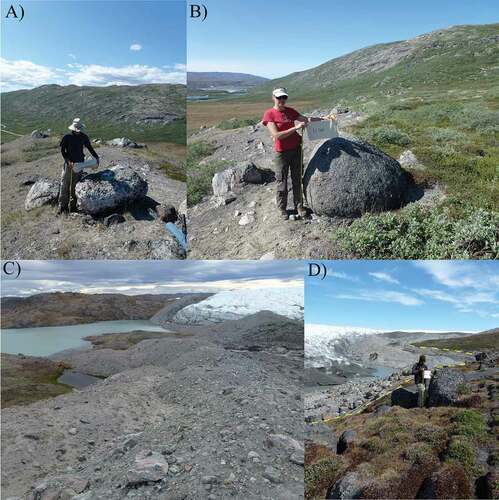
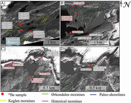
Figure 3. WorldView-2 satellite imagery showing the sample locations and ages (in ka). Sample name in parentheses with prefix “LL” removed. (A) Keglen moraines and boulder and bedrock samples atop Mount Keglen. 10Be samples from Winsor et al. (Citation2015) are outlined in blue. (B) Boulders on bedrock from the ridge on the south side of Moraine valley (JBC1006, JBC1007). Samples outlined in red are from Levy et al. (Citation2012). (C) Boulders on the historical moraine (LL1137, LL1139) as well as previously dated samples of Levy et al. (Citation2012) outlined in red. (D) Samples on the historical drift (LL1130, LL1131) and just distal to the historical trimline (LL1133)
Between the Ørkendalen moraines and the present-day ice margin are the historical moraines. In general, the historical moraines occur less than 100 m distal to the present-day ice margin and are steep-sided and ice-cored. They consist of fresh, unweathered boulders and host little to no vegetation (). The historical moraines in the Kangerlussuaq region are also characterized by having from two to three crests, indicating that they were created by multiple stillstands or readvances. In some locations the historical limit of the ice-sheet margin is not marked by a moraine, but instead is represented by an erosional trimline. This trimline appears as fresh, unweathered, glacially polished, and striated bedrock. In places, the bedrock is overlain by fresh, unweathered, perched boulders. The trimline is 50–200 m distal to the present-day ice margin, contiguous with the Ørkendalen drift (; Forman et al. Citation2007), and geographically correlates with the historical moraines. Based on lichenometry, the outermost historical moraine and associated trimline in the Kangerlussuaq region are thought to have formed between 80 and 120 years ago (Forman et al. Citation2007). Other historical moraines that occur along the western GrIS margin show high variability in timing and extent (Kelley et al. Citation2012). However, photographs and maximum-limiting radiocarbon ages indicate that a historical advance of the western GrIS margin culminated as late as the twentieth century (Kelley et al. Citation2012; Weidick Citation1968).
Methods
Mapping and dating of moraines
We conducted geomorphic mapping of the moraines and glacial features in the Kangerlussuaq region using 0.5 m-resolution WorldView-1 and -2 imagery as well as field observations. We obtained 10Be samples of boulders on both Keglen and historical moraines to determine the timing of moraine deposition. We also obtained 10Be samples of boulders perched on glacially polished bedrock to determine the timing of deglaciation of the landscape in between moraines. All samples are from the uppermost surfaces of large boulders (>1 m high) that were stable and had minimal evidence of erosion (e.g., ). We used the drill and blast method of Kelly (Citation2003) to obtain samples from the upper surfaces of boulders and bedrock. We processed all 10Be samples in the Cosmogenic Nuclide laboratory at Dartmouth College, using modified methods of Stone (Citation2001). 10Be/9Be ratios of the samples were measured at the Center for Accelerator Mass Spectrometry at Lawrence Livermore National Laboratory. We calculated 10Be ages using the CRONUS-Earth online calculator (v. 2.3; Balco et al. Citation2008) and using the Arctic production rate (Young et al. Citation2013b) and time invariant scaling by Lal (Citation1991) and Stone (Citation2000). We did not make corrections for isostatic uplift, snow cover, or erosion on the boulder surface.
Results
We present sixteen new 10Be ages of the Keglen moraines, boulders on bedrock, and bedrock surfaces on Mount Keglen, Ørkendalen drift, and the historical moraines. Six 10Be ages of boulders on the Keglen moraines range from 7.9 ± 0.2 (LL1109) to 8.1 ± 0.2 (LL1104), with a mean age of 8.0 ± 0.3 ka (uncertainty includes 1σ standard deviation of the mean and production rate uncertainty; , B and 3A; ). Three 10Be ages atop Mount Keglen are 7.8 ± 0.2 (LL1134, boulder), 8.1 ± 0.2 (LL1135a, bedrock), and 8.2 ± 0.2 ka (LL1136a, bedrock). These ages agree well with each other and show that there is little 10Be in the bedrock surfaces inherited from periods of prior exposure (; ). We suggest that this indicates significant subglacial erosion, which is common in samples from southern west Greenland (Young et al. Citation2016) and is supported by ice-erosional forms such as striations and crescentic gouges on the bedrock surface. The boulder and bedrock samples from the top of Mount Keglen align with the Keglen moraines and indicate ice-margin retreat at approximately the same time as deglaciation from the Keglen moraines 220 m below. Therefore, these ages constrain the thickness of the ice margin near Kangerlussuaq at about 8 ka–220 m.
Table 1. 10Be ages and sample information of boulders on moraines, boulders perched on glacially polished bedrock, and bedrock. We calculated all 10Be ages using the Arctic production rate (Young et al. Citation2013b) and the time-invariant scaling scheme of Lal (Citation1991) and Stone (Citation2000). The 10Be/9Be ratio for the three processing blanks ranged from 1.42 to 5.62 × 10⁻¹⁶. The 10Be ages reported here are slightly older than those reported by Levy (Citation2014) and Winsor et al. (Citation2015). This difference is because of an updated concentration of the 4G Beryl carrier
Two 10Be ages of boulders perched on a bedrock ridge on the south side of Moraine valley within the Ørkendalen drift (as mapped by Ten Brink Citation1975) are 7.0 ± 0.2 (JBC1006) and 7.2 ± 0.2 ka (JBC1007) (; ). These ages mark ice retreat at the same time as the Ørkendalen moraines approximately 130 m below, and therefore constrain the thickness of the ice margin at about 7.1 ka. A 10Be age of a boulder perched on bedrock just distal to the historical trimline is 7.0 ± 0.2 ka (LL1133) ( and ; ). Based on our mapping, this boulder is also within the Ørkendalen drift.
Two 10Be ages of boulders on the historical moraines are 0.1 ± <0.1 ka (LL1137) and 0.1 ± <0.1 ka (LL1139) ( and ; ) and are located on adjacent ridges. Sample LL1139 is from the most proximal ridge and LL1137 the next distal ridge. We did not sample the third and most distal ridge of the historical moraines because we could not find any boulders that were stable and not covered by till. Two boulders perched on bedrock along the historical trimline described by Forman et al. (Citation2007) date to 0.2 ± <0.1 ka (LL1130) and 5.3 ± 0.1 ka (LL1131) (; ). The older age (5.3 ± 0.1 ka) likely results from 10Be in the boulder surface inherited from a prior period of exposure. This is the only evidence for obvious inherited 10Be in our dataset, and we suggest that it is the result of insufficient erosion of the boulder surface, possibly because of a short subglacial transport distance to the historical trimline. We did not use sample LL1131 to determine the age of the historical ice extent and omit it from further discussion.
Discussion
Holocene deglaciation and GrIS margin fluctuations
Our age of the Keglen moraines (8.0 ± 0.3 ka, n = 6) agrees well with the previous estimates by van Tatenhove, van der Meer, and Koster (Citation1996) of 7.3 ± 0.6 cal kyr BP, using 14C-limiting ages (n = 4), and by Winsor et al. (Citation2015) of 8.0 ± 0.2 ka (n = 3), using 10Be ages (). The good agreement of 10Be ages between this study and Winsor et al. (Citation2015) serves as an encouraging inter-laboratory comparison, because the samples were collected separately and processed at different cosmogenic laboratories, but both were measured at Lawrence Livermore National Laboratory. Based on the age of the Keglen moraines (~8 ka), we suggest that they were formed in response to the 8.2 ka event (cf. Winsor et al. Citation2015), an abrupt cooling event when temperatures dropped 3.3 ± 1.1°C in less than approximately 20 years over Greenland (Alley et al. Citation1997; Kobashi et al. Citation2007; Rasmussen et al. Citation2007). The lack of cross-cutting relationships (van Tatenhove, van der Meer, and Koster Citation1996) and the small size of the moraines indicates that the Keglen moraines do not represent a large readvance of the ice margin, but, rather, a small stillstand or readvance associated with colder climate conditions (cf. Winsor et al. Citation2015).
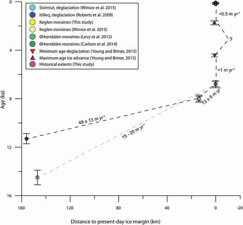
Figure 4. Time-distance diagram showing 10Be deglaciation ages between the outer coast and the present-day ice margin, east of Kangerlussuaq. Retreat rates between the two coastal sites, Itilleq and Sisimiut, are shown. Note that the Sisimiut to Keglen transect is north of the Itilleq to Keglen transect. We use the retreat rate from Itilleq to the Keglen moraines (49 ± 13 m yr−1) because it follows the flow line of the GrIS along the fjord Kangerlussuaq. Note that the rate of less than 0.5 m yr−1 refers to a readvance of the ice margin during late Holocene time
The Keglen moraines are nearly identical in age to the Tasiussaq moraines near Jakobshavn Isfjord (8.2–8.0 ka; Young et al. Citation2013a), about 220 km north of Kangerlussuaq, indicating that the GrIS responded nearly synchronously to the 8.2 ka event along its western Greenland margin. We suggest that the similar response of the ice sheet at distant locations was likely influenced by regional climate conditions, such as summer temperature. Summer temperature reconstructions (Axford et al. Citation2009) as well as glacier moraine records (Young et al. Citation2012) from Baffin Island, 800 km northwest from Kangerlussuaq, provide evidence for colder summers during the 8.2 ka event. Unfortunately, existing summer temperature reconstructions from along the GrIS margin in western Greenland only extend back to about 8 ka (Axford et al. Citation2013; D’Andrea et al. Citation2011; Thomas et al. Citation2016). We suggest that the 8.2 ka event may have involved a decrease in summer temperatures, and early Holocene summer temperature reconstructions extending beyond 8 ka along the western GrIS margin would provide valuable data.
The well-dated Ørkendalen moraines (6.8 ± 0.3 cal kyr BP, van Tatenhove, van der Meer, and Koster Citation1996; 6.8 ± 0.3 ka, Levy et al. Citation2012; 7.0 ± 0.3 ka, Carlson et al. Citation2014; ) are prevalent in the Kangerlussuaq region, but correlative moraines have not been mapped or dated elsewhere in western Greenland. To the north near Jakobshavn Isfjord, 10Be ages of boulders and bedrock just distal to the historical limit are approximately 7.6 ka (Carlson et al. Citation2014; Corbett et al. Citation2011; Young et al. Citation2013a), slightly older than the Ørkendalen moraines. It is possible that moraines coeval with the Ørkendalen moraines existed in the Jakobshavn Isfjord region but were subsequently overrun by the ice margin during the late Holocene. Therefore, it is unclear whether the Ørkendalen moraines mark a local or more regional response of the ice margin to climate conditions.
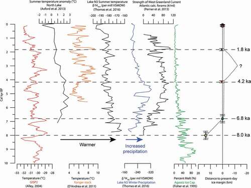
There is evidence for colder temperatures in some Greenland climate records coeval with the timing of Ørkendalen moraine deposition. The borehole corrected GISP2 temperature record, which registers mean annual temperatures atop the ice sheet (Alley Citation2004) shows cooling at about 7.1 ka, which is on a similar scale to the 8.2 ka event (). This cooling is also exhibited in the Lake N3 record of summer temperatures at 7.1 cal kyr BP (Thomas et al. Citation2016), and it may have caused a stillstand or readvance of the ice margin and therefore deposition of the Ørkendalen moraines (). However, it is unclear what caused the colder temperatures at about 7.1 cal kyr BP.
Figure 5. Records of Holocene climate conditions from Greenland and the Agassiz Ice Cap in Canada compared to a time-distance diagram of ice-margin fluctuations near Kangerlussuaq from 8 ka to the present. Horizontal dashed lines mark time constraints on ice-margin extents. The grey vertical line marks the present-day ice margin. The dotted line indicates our hypothesized ice-margin fluctuations at the study site. See for key of symbols
The 10Be ages from the historical moraines and trimline (0.1 ± <0.1 ka, 0.1 ± <0.1 ka, and 0.2 ± <0.1) suggest that 10Be dating can be used to date landforms deposited as late as the early twentieth century. Because there is only one 10Be age from each of the two most proximal moraine ridges, we cannot provide firm age constraints on the historical moraine ridges. However, using the range of ages (0.1–0.2 ka), we suggest that the historical moraines and trimline in the Kangerlussuaq region were formed within the past approximately 200 years. Ages of the historical moraines of the GrIS have been determined elsewhere in western Greenland (Weidick Citation1968, and references therein; Kelley et al. Citation2012; Weidick et al. Citation2012). Photographs and maximum-limiting radiocarbon ages of plant remains in historical moraines indicate that the culminating historical advance in the southeastern Disko Bugt region occurred during the twentieth century (Kelley et al. Citation2012), similar to our 10Be ages of historical moraines in the Kangerlussuaq region. A compilation of photographs, written reports, and drawings from more than fifty locations along the GrIS margin shows that two stillstands or readvances of the GrIS margin occurred at AD 1890 and AD 1920 with the AD 1890 extent representing the maximum historical extent of the ice sheet in many locations (Weidick Citation1968). Because of the high spatial variability of these data and the various dating methods, it is difficult to correlate the timing and extent of the historical limits along the western margin of the GrIS.
Early to middle Holocene retreat rates of a terrestrial GrIS margin
We used new and previously published 10Be ages of early to middle Holocene GrIS extents to estimate average retreat rates from the west coast of Greenland to the present-day ice margin, approximately along the fjord Kangerlussuaq. At the coast, 50 km north of the fjord mouth of Kangerlussuaq near the village of Itilleq, 10Be ages indicate that deglaciation occurred by 11.3 ± 0.6 ka (age recalculated using Arctic production rate [Young et al. Citation2013b] and Lal/Stone time invariant scaling [Lal Citation1991; Stone Citation2000]; ; Roberts et al. Citation2009). We calculate an average retreat rate of 49 ± 13 m yr−1 between the Itilleq at the coast and the Keglen moraines, 150 km to the northeast. We assume no major stillstands/readvances of the ice margin during this time (11.3–8.0 ka). However, there are at least three sets of mostly continuous moraines present between the coast and the Keglen moraines (Weidick Citation1968, Citation1972; Ten Brink Citation1975; ), and therefore our average retreat rate assumption may be incorrect. This rate is higher than that previously calculated by Winsor et al. (Citation2015), who estimate an average retreat rate of 15–20 m yr−1 using a transect of 10Be ages farther to the north, from the coastal town of Sisimiut to the present-day ice margin (14.5–6.8 ka; ).
Between the Keglen moraines (8.0 ± 0.3 ka) and the Ørkendalen moraines (6.8 ± 0.3 ka; ), we calculate an average retreat rate of 13 ± 6 m yr−1 (). Although some small recessional moraines exist between the Keglen and Ørkendalen moraines (), there is no evidence of major ice stillstands/readvances on the landscape between the two moraine sets. Therefore, we believe that our assumption about an average retreat rate is reasonable. We document a significant reduction in the ice retreat (more than threefold) after about 8.0 ka. After deposition of the Ørkendalen moraines, the ice-sheet margin retreated inland of its present-day margin, making it difficult to document ice-margin extents and fluctuations until the nineteenth century, when the historical moraines were deposited. A sediment record from Lake Lucy, located near to the left lateral margin of Isunnguata Sermia (Young and Briner Citation2015; ), shows minerogenic sediment input from the beginning of the record to 4.2 cal kyr BP, suggesting that the ice margin did not retreat more than 900 m inboard of the present-day ice margin until 4.2 cal kyr BP. Using this record, we calculate an average ice retreat rate of less than 1 m yr−1 (<900 m in 2.6 ka) for the time period 6.8 ka to 4.2 cal kyr BP. The Lake Lucy record also shows minerogenic input from 1.8 cal kyr BP to the present, indicating that the ice margin was less than 900 m behind its present-day extent for the past 1,800 years. Using the oldest 10Be age on the historical trimline (0.2 ± <0.1 ka; LL1130), we calculate that the ice margin advanced at a rate of approximately 0.5 m yr−1 from 1.8 cal kyr BP to the early nineteenth century (). Therefore, we document an overall pattern of relatively high average retreat rates in the early Holocene; significantly slower average retreat rates in the middle Holocene, and a slow readvance of ice during the late Holocene. This pattern of a faster early Holocene ice retreat near the coast and slower ice retreat closer to the present-day ice margin during the middle Holocene also has been documented for other areas along the western GrIS margin where average retreat rates were from two to seven times faster closer to the coast than near the present-day ice margin (Kelley, Briner, and Zimmerman Citation2015).
Potential causes for varying early to middle Holocene ice-retreat rates
The varying ice-margin retreat rates throughout the Holocene may have been influenced by changes in the proglacial environment and climate conditions. As the ice retreated inland of the head of the fjord Kangerlussuaq, it transitioned from a marine- to terrestrial-terminating ice margin. Marine-terminating glaciers are vulnerable to ice loss via submarine melting and calving, whereas terrestrial-terminating margins lose mass only by surface melting. The Keglen moraines are about 20 km northeast of the head of the fjord Kangerlussuaq, where the ice margin would have become terrestrial based. Therefore, the ice retreat rate may have slowed between the head of the fjord Kangerlussuaq and the Keglen moraines; however, we are only able to track the change in average retreat rate subsequent to the deposition of the Keglen moraines. Further dating of moraines between Itilleq and Kangerlussuaq would help constrain changes in the ice retreat rates and the mechanisms that influenced deglaciation in the region.
Climate conditions such as summer temperature and winter precipitation also likely influenced ice retreat rates. Three records of summer temperature and one of winter precipitation exist in western Greenland (Axford et al. Citation2013; D’Andrea et al. Citation2011; Thomas et al. Citation2016). Unfortunately, none of these records extend beyond 8 ka, and so it is not possible to evaluate the response of the ice margin to regional climate conditions prior to this time. A chironomid-based summer temperature record from North lake, situated less than 2 km north of Jackobshavn Isfjord and 240 km to the north of our study site, shows relatively warm temperatures from 6 to 3 cal kyr BP and cooling at AD 1880 (Axford et al. Citation2013), with an overall Holocene trend that closely resembles the Dye-3 borehole record (Dahl-Jensen et al. Citation1998). In comparison, a qualitative summer temperature record from Lake N3, 55 km south of Jakobshavn Isfjord, which is based on terrestrial leaf wax δ2H, shows a cooling trend from 8 to 6 cal kyr BP (Thomas et al. Citation2016). It is dissimilar to the North lake summer temperature record from 8 to 3 cal kyr BP, but the records are similar for the past approximately 3 cal kyr. An alkenone-based summer temperature record from near Kangerlussuaq, known as the Kanger Stack (D’Andrea et al. Citation2011), documents cooling from its onset at 5.6–5.0 cal kyr BP and then warming until 3 cal kyr BP. There are significant differences between these three summer temperature records from western Greenland, perhaps reflecting local climate differences between the Disko Bugt and Kangerlussuaq regions. Because of these differences, as well as the lack of local summer temperature records from the early Holocene, it is difficult to make a correlation between ice-margin retreat and summer temperatures in western Greenland. However, a farther afield record of relative summer temperatures from the Agassiz Ice Cap on Ellesmere Island, 1,800 km to the north of Kangerlussuaq, dates through the entire Holocene (Fisher, Koerner, and Reeh Citation1995; ). The Agassiz Ice Cap percent melt record documents warm summers from the early Holocene until about 6.8 ka, when percent melt becomes low (<20%) and constant for the remainder of the Holocene.
Only one record of winter precipitation exists for western Greenland. This is the Lake N3 record that is based on δ2H of aquatic leaf waxes (Thomas et al. Citation2016). It shows increasing winter precipitation from the start of the record at 8 cal kyr BP until about 4.5 cal kyr BP, a sharp decrease from 5.2 to 5.0 cal kyr BP, and then decreasing precipitation for the remainder of the Holocene (Thomas et al. Citation2016). Thomas et al. (Citation2016) link increased precipitation in western Greenland to the strength of the warm West Greenland Current (WGC; Perner et al. Citation2013) in the Labrador Sea. As the WGC strengthened throughout the early Holocene, it influenced a reduced sea-ice extent in Baffin Bay (Thomas et al. Citation2016) and the Labrador Sea (de Vernal et al. Citation2013) and created a nearby source for precipitation in western Greenland (cf. Thomas et al. Citation2016). The warm summer temperatures, such as those registered in the North lake record (Axford et al. Citation2013), may have also influenced reduced sea-ice extent in Baffin Bay and the Labrador Sea during the middle Holocene. The timing of increasing winter precipitation in the Lake N3 record corresponds to a decreased average ice-margin retreat rate near Kangerlussuaq, and the increased precipitation may have offset the amount of ice-margin retreat influenced by warm summer air temperatures (Thomas et al. Citation2016).
Determining the climate conditions that influenced changes in ice-margin retreat rates prior to the deposition of the Keglen moraines is difficult because the earliest nearby ice-margin climate records extend back only to approximately 8.0 ka (). However, the warm summers as documented by the Agassiz Ice Cap melt record correlate with the higher ice-margin retreat rates near Kangerlussuaq until about 6.8 ka, indicating that climate may have also influenced the early to middle Holocene ice-margin retreat rates. The continued decrease in average retreat rate of the ice margin from 6.8 ka to 4.2 cal kyr BP may have been influenced by increased winter precipitation (). Between 4.2 and 1.8 cal kyr BP, when the extent of the ice margin behind its present-day limit is not well-constrained, winter precipitation decreased and both the Kanger Stack and the North lake records document cooling summer temperatures from about 3 to 2 cal kyr BP (Axford et al. Citation2013; D’Andrea et al. Citation2011). The ice advance that culminated in the ice margin extending into the Lake Lucy catchment at 1.8 cal kyr BP until the twentieth century, when the historical moraines were deposited, was likely in response to cooler summer temperatures as registered in both the North lake and the Kanger Stack records (Axford et al. Citation2013; D’Andrea et al. Citation2011).
Conclusions
We present sixteen new 10Be ages that further constrain the Holocene extents of the western margin of the GrIS east of Kangerlussuaq. We show that the Keglen moraines date to 8.0 ± 0.3 ka (n = 6), and likely represent the response of the ice margin to the 8.2 ka event, an abrupt cooling registered in Greenland ice-core records. The average Holocene retreat rates of the GrIS margin slowed from 49 ± 13 m yr−1 (~11.3–8.0 ka) to about 13 ± 6 m yr−1 (8.0–6.8 ka). We suggest that this slowing was the result of the change from a marine-terminating to terrestrial-terminating margin at the head of the fjord Kangerlussuaq. After deposition of the Ørkendalen moraines, the average retreat rate of the ice margin decreased to less than 1 m yr−1 between 6.8 ka and 4.2 cal kyr BP. Based on a comparison with nearby summer temperature and winter precipitation records, we suggest that ice-margin retreat was likely influenced by warm summer temperatures during the early and middle Holocene, and may have been tempered by increased precipitation until the middle Holocene, as proposed by Thomas et al. (Citation2016). New 10Be ages on the historical moraines and associated erosional trimline constrain the timing of the historical ice advance to the past 200 years. The three historical moraine crests indicate that there were at least three ice-margin stillstands or advances during historical time. Summer temperature records from North lake (Axford et al. Citation2013) and Lake N3 (Thomas et al. Citation2016) broadly register cooling in the past 200 years in western Greenland, which likely influenced the advance to the historical moraines. The 10Be ages presented here will help constrain Holocene ice-sheet models, such as the Huy3 model (Lecavalier et al. Citation2014) that hindcast past fluctuations of the GrIS. However, a better understanding of the ice-margin fluctuations between the western coast of Greenland and Kangerlussuaq and more records of early Holocene climate conditions near the GrIS margin are needed to fully understand the mechanisms affecting the ice margin throughout the Holocene.
Acknowledgments
We thank Claire Arthur for her help with laboratory work. Polar Field Services provided logistical support and the 109th National Guard provided safe travel to and from Greenland.
Additional information
Funding
References
- Alley, R. 2004. GISP2 ice core temperature and accumulation data, IGBP PAGES/World data center for paleoclimatology. Boulder, CO: NOAA/NGDC Paleoclimatology Program.
- Alley, R. B., P. A. Mayewski, T. Sowers, M. Stuiver, K. C. Taylor, and P. U. Clark. 1997. Holocene climatic instability: A prominent, widespread event 8200 yr ago. Geology 25 (6):483–86. doi:https://doi.org/10.1130/0091-7613(1997)025<0483:HCIAPW>2.3.CO;2.
- Axford, Y., J. P. Briner, G. H. Miller, and D. R. Francis. 2009. Paleoecological evidence for abrupt cold reversals during peak Holocene warmth on Baffin Island, Arctic Canada. Quaternary Research 71 (2):142–49. doi:https://doi.org/10.1016/j.yqres.2008.09.006.
- Axford, Y., S. Losee, J. P. Briner, D. R. Francis, P. G. Langdon, and I. R. Walker. 2013. Holocene temperature history at the western Greenland Ice Sheet margin reconstructed from lake sediments. Quaternary Science Reviews 59:87–100.
- Balco, G., J. O. Stone, N. A. Lifton, and T. J. Dunai. 2008. A complete and easily accessible means of calculating surface exposure ages or erosion rates from 10 Be and 26 Al measurements. Quaternary Geochronology 3 (3):174–95. doi:https://doi.org/10.1016/j.quageo.2007.12.001.
- Bindschadler, R. A., S. Nowicki, A. Abe-Ouchi, A. Aschwanden, H. Choi, J. Fastook, G. Granzow, R. Greve, G. Gutowski, and U. Herzfeld. 2013. Ice-sheet model sensitivities to environmental forcing and their use in projecting future sea level (the SeaRISE project). Journal of Glaciology 59 (214):195–224. doi:https://doi.org/10.3189/2013JoG12J125.
- Briner, J., H. Stewart, N. Young, W. Philipps, and S. Losee. 2010. Using proglacial-threshold lakes to constrain fluctuations of the Jakobshavn Isbræ ice margin, western Greenland, during the Holocene. Quaternary Science Reviews 29 (27):3861–74. doi:https://doi.org/10.1016/j.quascirev.2010.09.005.
- Briner, J. P., N. P. McKay, Y. Axford, O. Bennike, R. S. Bradley, A. de Vernal, D. Fisher, P. Francus, B. Fréchette, and K. Gajewski, A. Jennings, D. S. Kaufman, G. Miller, C. Rouston, and B. Wagner. 2016. Holocene climate change in Arctic Canada and Greenland. Quaternary Science Reviews 147:340–64.
- Carlson, A. E., K. Winsor, D. J. Ullman, E. J. Brook, D. H. Rood, Y. Axford, A. N. LeGrande, F. S. Anslow, and G. Sinclair. 2014. Earliest Holocene south Greenland ice sheet retreat within its late Holocene extent. Geophysical Research Letters 41 (15):5514–21. doi:https://doi.org/10.1002/2014GL060800.
- Corbett, L. B., N. E. Young, P. R. Bierman, J. P. Briner, T. A. Neumann, D. H. Rood, and J. A. Graly. 2011. Paired bedrock and boulder 10Be concentrations resulting from early Holocene ice retreat near Jakobshavn Isfjord, western Greenland. Quaternary Science Reviews 30 (13):1739–49.
- D’Andrea, W. J., Y. Huang, S. C. Fritz, and N. J. Anderson. 2011. Abrupt Holocene climate change as an important factor for human migration in West Greenland. Proceedings of the National Academy of Sciences 108 (24):9765–69. doi:https://doi.org/10.1073/pnas.1101708108.
- Dahl-Jensen, D., K. Mosegaard, N. Gundestrup, G. D. Clow, S. J. Johnsen, A. W. Hansen, and N. Balling. 1998. Past temperatures directly from the Greenland ice sheet. Science 282 (5387):268–71. doi:https://doi.org/10.1126/science.282.5387.268.
- de Vernal, A., C. Hillaire-Marcel, A. Rochon, B. Fréchette, M. Henry, S. Solignac, and S. Bonnet. 2013. Dinocyst-based reconstructions of sea ice cover concentration during the Holocene in the Arctic Ocean, the northern North Atlantic Ocean and its adjacent seas. Quaternary Science Reviews 79:111–21.
- Fisher, D. A., R. M. Koerner, and N. Reeh. 1995. Holocene climatic records from Agassiz ice cap, Ellesmere Island, NWT, Canada. The Holocene 5 (1):19–24. doi:https://doi.org/10.1177/095968369500500103.
- Forman, S. L., L. Marin, C. Veen, C. Tremper, and B. Csatho. 2007. Little ice age and neoglacial landforms at the Inland Ice margin, Isunguata Sermia, Kangerlussuaq, west Greenland. Boreas 36 (4):341–51. doi:https://doi.org/10.1080/00173130601173301.
- Funder, S., K. K. Kjeldsen, K. H. Kjær, and C. Ó Cofaigh. 2011. The Greenland Ice Sheet during the past 300,000 years: A review. In Quaternary glaciations, extent and chronology: A closer look, ed. J. Ehlers, P. L. Gibbard, and P. D. Hughes, 699–713. Amsterdam, The Netherlands: Elsevier.
- Kaufman, D., T. Ager, N. Anderson, P. Anderson, J. Andrews, P. Bartlein, L. Brubaker, L. Coats, L. C. Cwynar, and M. Duvall. 2004. Holocene thermal maximum in the western Arctic (0–180 W). Quaternary Science Reviews 23 (5):529–60. doi:https://doi.org/10.1016/j.quascirev.2003.09.007.
- Kelley, S. E., J. P. Briner, N. E. Young, G. S. Babonis, and B. Csatho. 2012. Maximum late Holocene extent of the western Greenland Ice Sheet during the late 20th century. Quaternary Science Reviews 56:89–98.
- Kelley, S. E., J. P. Briner, and S. R. Zimmerman. 2015. The influence of ice marginal setting on early Holocene retreat rates in central West Greenland. Journal of Quaternary Science 30 (3):271–80. doi:https://doi.org/10.1002/jqs.2778.
- Kelly, M.A. 2003. The late Würmian Age in the western Swiss Alps – last glacial maximum (LGM) ice-surface reconstruction and 10Be dating of late-glacial features, PhD diss., University of Bern.
- Kobashi, T., J. P. Severinghaus, E. J. Brook, J.-M. Barnola, and A. M. Grachev. 2007. Precise timing and characterization of abrupt climate change 8200 years ago from air trapped in polar ice. Quaternary Science Reviews 26 (9):1212–22. doi:https://doi.org/10.1016/j.quascirev.2007.01.009.
- Lal, D. 1991. Cosmic ray labeling of erosion surfaces: In situ nuclide production rates and erosion models. Earth and Planetary Science Letters 104 (2–4):424–39. doi:https://doi.org/10.1016/0012-821X(91)90220-C.
- Larsen, N. K., S. Funder, K. H. Kjær, K. K. Kjeldsen, M. F. Knudsen, and H. Linge. 2014. Rapid early Holocene ice retreat in West Greenland. Quaternary Science Reviews 92:310–23.
- Lecavalier, B. S., G. A. Milne, M. J. Simpson, L. Wake, P. Huybrechts, L. Tarasov, K. K. Kjeldsen, S. Funder, A. J. Long, and S. Woodroffe. 2014. A model of Greenland ice sheet deglaciation constrained by observations of relative sea level and ice extent. Quaternary Science Reviews 102:54–84.
- Levy, L. B. 2014. Late glacial and Holocene fluctuations of local glaciers and the Greenland Ice Sheet, eastern and western Greenland. Hanover, NH: Dartmouth College.
- Levy, L. B., M. A. Kelly, J. A. Howley, and R. A. Virginia. 2012. Age of the Ørkendalen moraines, Kangerlussuaq, Greenland: Constraints on the extent of the southwestern margin of the Greenland Ice Sheet during the Holocene. Quaternary Science Reviews 52:1–5.
- Nishiizumi, K., M. Imamura, M. W. Caffee, J. R. Southon, R. C. Finkel, and J. McAninch. 2007. Absolute calibration of 10 Be AMS standards. Nuclear Instruments and Methods in Physics Research Section B: Beam Interactions with Materials and Atoms 258 (2):403–13. doi:https://doi.org/10.1016/j.nimb.2007.01.297.
- Perner, K., M. Moros, A. Jennings, J. M. Lloyd, and K. L. Knudsen. 2013. Holocene palaeoceanographic evolution off West Greenland. The Holocene 23 (3):374–87. doi:https://doi.org/10.1177/0959683612460785.
- Rasmussen, S. O., B. M. Vinther, H. B. Clausen, and K. K. Andersen. 2007. Early Holocene climate oscillations recorded in three Greenland ice cores. Quaternary Science Reviews 26 (15–16):1907–14. doi:https://doi.org/10.1016/j.quascirev.2007.06.015.
- Rinterknecht, V., Y. Gorokhovich, J. Schaefer, and M. Caffee. 2009. Preliminary 10Be chronology for the last deglaciation of the western margin of the Greenland Ice Sheet. Journal of Quaternary Science 24 (3):270–78. doi:https://doi.org/10.1002/jqs.v24:3.
- Roberts, D. H., A. J. Long, C. Schnabel, B. J. Davies, S. Xu, M. J. Simpson, and P. Huybrechts. 2009. Ice sheet extent and early deglacial history of the southwestern sector of the Greenland Ice Sheet. Quaternary Science Reviews 28 (25–26):2760–73. doi:https://doi.org/10.1016/j.quascirev.2009.07.002.
- Stocker, T., D. Qin, G. Plattner, M. Tignor, S. Allen, J. Boschung, A. Nauels, Y. Xia, B. Bex, and B. Midgley. 2013. IPCC, 2013: Climate change 2013: The physical science basis. Contribution of working group I to the fifth assessment report of the Intergovernmental Panel on Climate Change New York, NY: Cambridge University Press.
- Stone, J., 2001. Extraction of Al & Be from Quartz for isotopic analysis. http://depts.washington.edu/cosmolab/chem/Al-26_Be-10.pdf
- Stone, J. O. 2000. Air pressure and cosmogenic isotope production. Journal of Geophysical Research: Solid Earth (1978–2012) 105 (B10):23753–59. doi:https://doi.org/10.1029/2000JB900181.
- Ten Brink, N. W. 1975. Holocene history of the Greenland ice sheet based on radiocarbon-dated moraines in West Greenland. Meddelelser Om Grønland 201 (4):1–44.
- Ten Brink, N. W., and A. Weidick. 1974. Greenland ice sheet history since the last glaciation. Quaternary Research 4 (4):429–40. doi:https://doi.org/10.1016/0033-5894(74)90038-6.
- Thomas, E. K., J. P. Briner, J. J. Ryan-Henry, and Y. Huang. 2016. A major increase in winter snowfall during the middle Holocene on western Greenland caused by reduced sea ice in Baffin Bay and the Labrador Sea. Geophysical Research Letters 43 (10):5302–8. doi:https://doi.org/10.1002/2016GL068513.
- van Tatenhove, F. G., J. J. van der Meer, and E. A. Koster. 1996. Implications for deglaciation chronology from new AMS age determinations in central West Greenland. Quaternary Research 45 (3):245–53. doi:https://doi.org/10.1006/qres.1996.0025.
- Weidick, A. 1968. Observations on some Holocene glacier fluctuations in west Greenland. Meddelelser om Grønland 165:1–202.
- Weidick, A. 1972. Holocene shore-lines and glacial stages in Greenland: An attempt at correlation. Grønlands Geologiske Undersøgelse, 1–39.
- Weidick, A. 1976. Glaciation and the Quaternary of Greenland. Geology of Greenland 4:431–458.
- Weidick, A., O. Bennike, M. Citterio, and N. Nørgaard-Pedersen. 2012. Neoglacial and historical glacier changes around Kangersuneq fjord in southern West Greenland. Geological Survey of Denmark and Greenland Bulletin vol. 27.
- Winsor, K., A. E. Carlson, M. W. Caffee, and D. H. Rood. 2015. Rapid last-deglacial thinning and retreat of the marine-terminating southwestern Greenland ice sheet. Earth and Planetary Science Letters 426:1–12.
- Young, N. E., and J. P. Briner. 2015. Holocene evolution of the western Greenland Ice Sheet: Assessing geophysical ice-sheet models with geological reconstructions of ice-margin change. Quaternary Science Reviews 114:1–17.
- Young, N. E., J. P. Briner, J. Maurer, and J. M. Schaefer. 2016. 10Be measurements in bedrock constrain erosion beneath the Greenland Ice Sheet margin. Geophysical Research Letters 43 (22):11,708–11,719. doi:https://doi.org/10.1002/2016GL070258.
- Young, N. E., J. P. Briner, D. H. Rood, and R. C. Finkel. 2012. Glacier extent during the Younger Dryas and 8.2-ka event on Baffin Island, Arctic Canada. Science 337 (6100):1330–33. doi:https://doi.org/10.1126/science.1222759.
- Young, N. E., J. P. Briner, D. H. Rood, R. C. Finkel, L. B. Corbett, and P. R. Bierman. 2013a. Age of the Fjord Stade moraines in the Disko Bugt region, western Greenland, and the 9.3 and 8.2 ka cooling events. Quaternary Science Reviews 60:76–90.
- Young, N. E., J. P. Briner, H. A. Stewart, Y. Axford, B. Csatho, D. H. Rood, and R. C. Finkel. 2011. Response of Jakobshavn Isbræ, greenland, to Holocene climate change. Geology 39 (2):131–34. doi:https://doi.org/10.1130/G31399.1.
- Young, N. E., J. M. Schaefer, J. P. Briner, and B. M. Goehring. 2013b. A 10Be production‐rate calibration for the Arctic. Journal of Quaternary Science 28 (5):515–26. doi:https://doi.org/10.1002/jqs.v28.5.