
ABSTRACT
There is a lack of detailed information on the Holocene evolution of the west Greenland ice margin, not least because it was farther inland than at present and thus at present is covered by ice. Suggestions have been put forward, both of relatively quick ice-margin retreat and of relatively stable ice-margin positions. This study presents the first exploitation of sediments from an ice-dammed basin. Sediment that is rich in organic material records a period of time sufficient for vegetation to thrive; thus, without a lake and with a distal and diminished ice mass relative to the present. In contrast, sediment composed of suspension-settling deposits and with drop stones records an ice-dammed lake and a proximal calving ice-margin. Overall, we evidence relatively coarse-grained glacifluvial sedimentation predominantly from an ice-marginal delta and/or a proglacial, braided river soon after the early Holocene deglaciation of this area. Subsequent mid-Holocene aeolian activity deposited leaves, some vegetation (roots) developed in the basin, and ponding of water formed organic-rich “gyttja” sediments and thin layers of peat. The lake then became ice marginal, and ice advances are interpreted to have occurred at approximately 4000 cal. yr BP, and between 2776 ± 26 cal. yr BP and 2440 ± 45 cal. yr BP. The Little Ice Age ice-margin advance at Russell Glacier apparently reached its maximum extent after 147 ± 39 cal. yr BP, whereas at Isunnguata Sermia the maximum could have been as early as 245 ± 26 cal. yr BP. Given that ice-marginal lakes are becoming globally ubiquitous, improved resolution and new geological data on lake and ice-margin dynamics and interactions, such as ice-dammed lake-basin sediments, will be important for numerical models for assessing past and future ice-mass evolution.
Introduction
The ice margin in west Greenland has experienced both advance and retreat phases during the mid-late Holocene. Quantification of the spatiotemporal dimensions of these ice-margin changes is therefore desirable for understanding ice-sheet mass-balance responses to climate change. However, because the ice margin was farther inland than at present during the mid-late Holocene, the landform and sedimentary evidence needed for such quantification is extremely limited.
Table 1. Radiocarbon ages from ice-dammed lakes at the margin of Russell Glacier and Isunnguata Sermia. Calibration is based on the IntCal13 calibration curves (Reimer et al. Citation2013)
Evidence in the form of submarine moraines has confirmed that the western ice margin of the Greenland Ice Sheet (GrIS) began to retreat from its Last Glacial Maximum (LGM), or Sisimiut glaciation, position beyond the present coastline at approximately 10,800 cal. yr BP (Bennike and Björck Citation2002; Bennike, Wagner, and Richter Citation2011). At that time, global sea level was approximately 120 m lower than today, and the western Greenland land mass was isostatically depressed. Marine sediments deposited within the outer reaches of fjords and ridges of moraine with crests aligned in a north-south direction together evidence that the ice margin in west Greenland had reached a position shortly behind the present coastline by approximately 9500 cal. yr BP (Young and Briner Citation2015).
On land, the general retreat during the Holocene Thermal Maximum (HTM; 9000–5000 cal. yr BP) was punctuated by several minor ice-margin readvances, which left a series of large-scale and near-continuous sinuous and lobate major moraine systems across west Greenland. These major moraines were classified, dated, and named by Ten Brink and Weidick (Citation1974), Ten Brink (Citation1975), van Tatenhove, van der Meer, and Koster (Citation1996), Rinterknecht et al. (Citation2009), and Levy et al. (Citation2012). Prominent moraine ridges situated approximately halfway between Sisimiut and Kangerlussuaq have been used to evidence that the ice margin in west Greenland had a minor advance at approximately 8700 cal. yr BP, and Fjordstade moraines at Strømfjordshavn (about 20 km west of Kangerlussuaq) evidence another small ice-margin advance at approximately 8100 yr BP (Funder and Hansen Citation1996; Ten Brink Citation1975; van Tatenhove, van der Meer, and Koster Citation1996).
In the Kangerlussuaq-Russell Glacier area of west Greenland (), further insights into the mid-late Holocene landscape evolution have been gained by analyses of lake sediments (Aebly and Fritz Citation2009; Anderson and Leng Citation2004; Eisner et al. Citation1995; Young and Briner Citation2015; Young et al. Citation2013) and valley fill sediments (Storms et al. Citation2012). These observations in combination give the most recent consensus that the Fjordstade moraine system dates to 8340–9080 cal. yr BP, the Umîvît moraine system to 7360–7960 cal. yr BP, the Keglen moraine system to 6490–7190 cal. yr BP, and the Ørkendalen moraine system to 6400–7030 cal. yr BP (Storms et al. Citation2012).
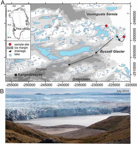
Figure 1. Location in west Greenland of the lake basins considered in this study and of local topography and contemporary ice-margin configuration (A): Image of an approximately 1 km-wide ice-dammed lake on the northern margin of Russell Glacier in a semidrained state in July 2014. (B): Grid coordinates are UTM 22N
The innermost parts of the fjord Kangerlussuaq () were free of ice by approximately 8000 cal. yr BP. The area of tundra between Kangerlussuaq and Russell Glacier was probably ice free from approximately 6800 cal. yr BP. This date is suggested by 10Be cosmogenic datings of the Ørkendalen moraines (Levy et al. Citation2012) and the presence of organic material underlain by about 1 m of glacifluvial sediment, dated at approximately 5700–5850 cal. yr BP (Eisner et al. Citation1995). The organic material presumably required a considerable amount of time to accumulate. Lake-sediment investigations have also indicated that the climate during the period 8000–4300 cal. yr BP was more arid than today, with higher air temperatures and less precipitation (Anderson and Leng Citation2004). The peak warming during the HTM was probably between 6000 and 5000 yr BP (Renssen et al. Citation2012), although regionally it may have occurred as late as 3500–2000 cal. yr BP (Kaufman et al. Citation2004; Young and Briner Citation2015). The greatest retreat (i.e., the easternmost ice-margin position during the Holocene) of the GrIS in west Greenland was probably reached between 5000 and 4000 yr BP, where the ice-sheet margin may have been located as far inland as 80 km from its current position (Simpson et al. Citation2009). However, the timing and degree of the minimum extent is very uncertain (Simpson et al. Citation2009; Young and Briner Citation2015; Young et al. Citation2013).
Optically stimulated luminescence (OSL) dates from the bottom of aeolian sediment beds have been used by Forman et al. (Citation2007) together with an absence of any younger moraines to suggest that the area of tundra between Russell Glacier and Isunnguata Sermia () has been continuously deglaciated between approximately 6000 and 2000 cal. yr BP. In the same area, a neoglacial (2000 yr BP) moraine ridge closely corresponds in position to Little Ice Age (LIA) moraines and to the position of the present ice margin (Forman et al. Citation2007). Thus, the ice margin in western Greenland has apparently been remarkably stable in position throughout the past 2,000 years.
Despite these efforts in geochronological and geomorphological disciplines, there remains a lack of relatively detailed information on the mid-late Holocene temporal evolution of the ice margin in west Greenland. Suggestions of relatively quick retreat, or of relatively stable ice-margin positions as mentioned previously, could simply be an artifact of the limited spatiotemporal information presently available.
The aim of this study is therefore to present the first exploitation of peat layers found within ice-dammed lake sediments to provide a centennial-millennial scale assessment of ice-margin fluctuations in west Greenland during the mid-late Holocene. A similar exploitation of organic layers within proglacial lake sediments was very recently reported by Larsen et al. (Citation2017) working in southwest Greenland.
Study site: Ice-dammed lakes near Kangerlussuaq, west Greenland
An aerial photograph, “Geodetic Institute route B 23 A-L, no.92,” obtained in 1942 and reproduced in Weidick (Citation1968), together with aerial photographs taken on August 17, 1968 and 1974, and an observation from an aeroplane in 1982 (Scholz, Schreiner, and Funk Citation1988) have been used with more recent field observations (1) to identify eight ice-dammed lake basins in the vicinity of Kangerlussuaq () that have experienced marked water fluctuations because of lake drainage and subsequent refilling (Scholz, Schreiner, and Funk Citation1988) and (2) to characterize multiple drainages of the most prominent of these ice-dammed lakes, which is approximately 1 km2 and at 420 m a.s.l. and is situated on the northern flank of Russell Glacier (). Ice-dammed lakes drain either gradually, because of ice-margin recession, or suddenly, because of a failure of the ice dam. In the latter case, the integrity of an ice dam depends on the balance between the hydrostatic pressure exerted by the lake water and thus lake-water depth, and the ice overburden pressure, which is largely a function of ice thickness (Carrivick and Tweed Citation2013). The ice-dammed lake on the northern margin of Russell Glacier drains englacially and thence into a cascade series of other proglacial lakes (; Russell et al. Citation2011; Carrivick et al. Citation2013; Carrivick et al. Citation2016).
Historically, this ice-dammed lake drained repeatedly from the late 1940s to July 17–19, 1987 (Gordon Citation1986; Russell Citation1989, 1988; Russell and De Jong Citation1989; Sugden, Clapperton, and Knight Citation1985). Then, following twenty years of a relatively stable lake level, a glacier outburst flood, or jökulhlaup, on August 31, 2007, marked renewed ice-dammed lake drainage (Mernild et al. 2008; Mernild and Hasholt Citation2009) and a new jökulhlaup cycle (Russell et al. Citation2011). To date, this new cycle has resulted in lake drainages and jökulhlaups almost every year, specifically on August 31, 2007, August 31, 2008, September 11, 2010, August 14, 2011, August 11–12, 2012, September 14–15, 2013, August 3, 2014, and July 28, 2015. The longer-term (centennial to millenial) evolution of this lake and of the many other ice-dammed lakes in west Greenland (Carrivick and Quincey Citation2014; Carrivick et al. Citation2016, 2017) is to date unknown, despite the importance of that knowledge for (1) meltwater discharge and chemistry (Mikkelsen et al. Citation2013; Yde et al. Citation2014), (2) sediment transfers and proglacial landscape evolution (Anderson et al. Citation2017; Carrivick et al. Citation2013), and for (3) inferring ice-margin configuration and hence ice-sheet mass-balance fluctuations.
Methods
On July 27, 2008, a vertical profile was excavated into the bank of a gully, which was eroded into the lake bed during the 2007 jökulhlaup. The profile was located in the central part of the drained lake, approximately 600 m from the ice margin (). Permafrost was not encountered during the excavation of the profile in 2008, but when the site was revisited in August 2009 the ground was frozen.
The profile was logged to a depth of 1.92 m, and the lithofacies were described in situ with respect to lithology, structures, and grain sizes. Below 1.92 m, there was a layer of sand overlying a boulder-rich layer, which prevented further excavation. Five samples () of organic material were collected in polyethylene bags for 14C dating. The dating analyses were conducted at the AMS 14C Dating Centre at Aarhus University using mass spectrometry. The 14C ages (before year 1950) are reported in calendar years before present (year 2000) obtained from IntCal13 calibration curves (Reimer et al. Citation2013).
In addition, two samples of organic material were collected for 14C dating from a shallow profile at a partly drained lake located 6.5 km northwest of the large ice-dammed lake on the southern margin of the outlet glacier Isunnguata Sermia ().
Our quantification of the ice-dammed lake bathymetry was made via differential Global Positioing System measurements, as described by Russell et al. (Citation2011). The quantification of distributed glacier-bed topography was obtained by combining ice-thickness data (Bamber et al. Citation2013), InSAR-derived ice surface (Palmer et al. Citation2011) and IceBridge data (Leuschen Citation2013), and was gridded with a 100 m cell size.
Results
Profile description
The base of the profile () was delimited by a clast-supported boulder layer, which prevented further excavation. A massive (structureless) medium-grained and greenish-tinted sand with some lenses of clast-supported rounded fine- to medium-grained gravel was present below 1.92 m depth (). A gyttja (an organic-rich, fine-grained lake deposit) layer at 1.60–1.92 m () visually contained more organic material than those types of layers above; it was darker in color and composed of many root and leaf fragments. Some cobbles were also found within this gyttja layer and the matrix was generally silty. A 14C dating of the roots and leaves within this gyttja layer yielded a calibrated age of 3480 ± 45 cal. yr BP (SampleID 12974; 14C age = 3217 ± 40 cal. yr BP).
Figure 2. Image of the sediment profile excavated from the ice-dammed lake basin on the northern margin of Russell Glacier (A) and the corresponding sediment log and basic description (B)
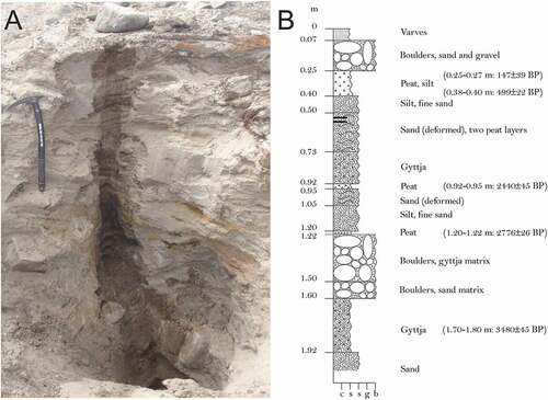
Another boulder-rich layer was found between the lowermost thin organic peat layer and the lower gyttja layer. It consisted of an upper dark part (at 1.22–1.50 m depth) with a gyttja matrix and a lower lighter part (at 1.50–1.60 m depth) with a sand matrix (). A thin peat layer was found between 1.20 m and 1.22 m depth and yielded a calibrated age of 2776 ± 26 cal. yr BP (SampleID 12973; 14C age = 2560 ± 39 cal. yr BP). A nonstructured layer of sand and silt was between 1.05 m and 1.20 m depth, and an irregularly deformed layer of fine sand and gravel was between 0.95 m and 1.05 m. A thin organic layer of peat occurred between 0.92 m and 0.95 m depth. Dating of this peat layer produced a calibrated age of 2440 ± 45 cal. yr BP (SampleID 12972; 14C age = 2369 ± 35 cal. yr BP).
The uppermost layer of gyttja was located between 0.73 m and 0.92 m depth, and consisted of organic material mixed with coarse-grained sand (). This gyttja layer was situated immediately above one of the thin peat layers. The matrix of this upper gyttja layer was less silty than the lower gyttja layer. A couple of thin organic-rich laminae were found between 0.55 m and 0.60 m depth and within a unit of fine sand (). A grey-brown layer of silt and fine sand with cross bedding was found between 0.40 m and 0.50 m depth, and was underlain by an irregularly deformed layer at 0.50 m to 0.73 m depth. It had laminations of coarse sand and two thin peat laminae (). Peat material from the 0.40 m depth part of this layer produced a calibrated age of 499 ± 22 cal. yr BP (SampleID 12975; 14C age = 353 ± 24 cal. yr BP). A thick coherent layer of peat with a well-sorted, silty matrix lay between 0.25 m and 0.40 m depth (). Organic material extracted from 0.25 m depth (the top of this layer) yielded a calibrated age of 147 ± 39 cal. yr BP (SampleID 12971; 14C age = 108 ± 32 cal. yr BP). No organic layers or laminations were found stratigraphically above. A boulder-rich layer lay between 0.07 m and 0.25 m (). The matrix between the boulders was dominated by sand and gravel. The top of the profile to approximately 0.07 m depth comprised a fragile sequence of approximately sixteen to seventeen laminae each of 1–3 mm thickness (). This varve layer was seen to be continuous spatially across the surface of the drained lake basin.
Interpretation
The presence of homogeneous and unstructured medium-grained sand with gravel lenses at a depth of 1.90 m or more, without any visible sign of organic material, indicates that this relatively coarse-grained deposition took place as a result of flowing water. The most likely source of flowing water is from the (then retreating) ice margin, and so we consider these sediments to most likely represent proglacial, perhaps ice-marginal, and either deltaic or braided river meltwater deposits.
Boulders within the lower gyttja layer at 1.60–1.92 m depth are most likely dropstones from icebergs. We do not consider the boulders to be a product of sudden lake drainage and jökulhlaups, because while being more than capable of transporting large-caliber sediment, contemporary (and thus presumably past) floods initially route subglacially (); that is, not over our sample site. Furthermore, while boulders can be found within moraine along the contemporary ice-sheet margin, they are otherwise uncommon in the surrounding landscape.
The finely bedded silt and sand layers most likely derive from deposition of suspended sediments, and the lack of boulders within those silt and sand layers could be interpreted to indicate either that no iceberg calving occurred or that the source of boulders from the ice margin had become exhausted.
Given that the matrix of the lower gyttja layer was more silty than the upper gyttja layer, deposition from suspension settling from lake inflows is probable, but aeolian activity cannot be excluded as a possible source. The uppermost layer of gyttja, located between 0.73 m and 0.92 m depth, is interpreted to have been formed when vegetation was subaqueously drowned. The sand layer above (0.73–0.50 m) could have formed as part of a delta or fan.
The thin organic-rich laminae between 0.55 m and 0.60 m depth are interpreted to represent episodes when the ice-dammed lake had been drained for sufficient time for vegetation to establish—a time period probably on the order of several decades. The irregular deformation within the sand layer indicates post-depositional cryoturbation, which must have occurred during time periods when the lake was drained.
The uppermost layer of plants and peat with a well-sorted, silty matrix very likely derives from aeolian deposition, as seen currently throughout the study area (Bullard and Austin Citation2011; Dijkmans and Törnqvist Citation1991). Because no organic layers or laminations were found stratigraphically above, and because of its age (147 cal. yr BP–499 cal. yr BP), we interpret that this organic layer represents the most recent period when the extent of the GrIS was diminished relative to the present-day position of the ice-sheet margin. The number of laminae from the top to 0.07 m depth is virtually consistent with the twenty years that elapsed between lake drainage and major jökulhlaup in 1987 and the onset of a new cycle of jökulhlaups that initiated in 2007 (Russell et al. Citation2011). Because of their grain size, laminae bedding, and number they are therefore interpreted as (annual) varves.
Overall, the profile obtained from the ice-dammed lake basin () constituted two main genetic facies: a terrestrial facies, characterized by organic-rich material, and a glaciolacustrine facies, dominated by lithogenic deposits. In addition, layers distinctive for being of sediment-rich in organic matter (i.e., gyttja deposits) are identified, but we acknowledge that these layers could genetically belong to one or both of the terrestrial or glaciolacustrine facies. The profile did not contain any sediments that could be interpreted as till deposits or any sediments that contained any other signs of having been glacier covered.
14C datings from a drained lake at Isunnguata Sermia
The partially drained ice-marginal lake at the southern lateral margin of the GrIS outlet glacier Isunnguata Sermia is smaller than the ice-marginal lake at Russell Glacier, and its drainage history is unknown. When samples were collected, the ground contained permafrost, making it impossible to get a complete vertical profile.
The top layer consisted of silt and sand, and a dark peat layer was found below that. A 14C date of a sample from the top of the peat yielded a calibrated age of 245 ± 26 cal. yr BP (SampleID 13777; 14C age = 159 ± 31 cal. yr BP), whereas 14C dating of the bottom of the peat produced a calibrated age of 3944 ± 38 cal. yr BP (SampleID 13779; 14C age = 3601 ± 39 cal. yr BP). The peat layer appeared (visually) coherent, so we interpret that this lake did not exist between 245 and 3944 cal. yr BP.
Discussion
Changes between the two main genetic facies represent environmental changes in the history of the ice-dammed lake and serve as a proxy for the relative position of the ice-sheet margin. During periods with vegetation cover at the point of the profile sample, we consider that there must have been no ice-marginal lake, and thus the margin of the GrIS must have been located further inland than at present (i.e., the regional extent of the GrIS was smaller than today). In contrast, deposition of glaciolacustrine sediments is an indication of a GrIS with a similar or slightly larger extent and thickness than at present. The same interpretations of environmental changes from similar main genetic facies of proglacial lake sediments have very recently been reported by Larsen et al. (Citation2017) from work in southwest Greenland.
We also consider that the ice-dammed lake was controlled during the Holocene as it is today. The lake fills up to the level of its terrestrial bedrock spillway during periods with thick ice and consequently with no jökulhlaups (Carrivick et al. Citation2013). When the ice margin is thinner and sudden lake drainages occur, the lake refills immediately after each jökulhlaup (Russell et al. Citation2011). If the ice margin were to retreat from its present position, a new lower spillway at the southwestern corner of the lake would route meltwater along the ice margin and thereby prevent the formation of the lake. In consideration of a more advanced ice margin (during the 3480 ± 45 cal. yr BP time period covered by the profile) in comparison to that of today, we note that there are no moraine deposits around the shores of the lake, and the only moraine ridges on the northern margin of Russell Glacier were formed during AD 1985 and 2000 (Knight et al. Citation2000, Citation2007).
The relatively coarse grain size of the deltaic-type sediments at 1.90 m or more depth indicates that the distance to the glacier margin was probably small during this phase of deposition (). This interpretation, with a note of an absence of boulders in these facies, as well as the stratigraphic context of these sediments relative to the rest of the profile (and hence the ensuing environmental history part of which we have dated), helps us to propose that that these delta-type or braided river–type sediments formed following the retreat of the ice margin of the GrIS across the area (). Consensus in the literature places this deglaciation/ice retreat in this part of west Greenland as initiating at approximately 7000–6800 cal. yr BP (Carlson et al. Citation2014; Levy et al. Citation2012; Storms et al. Citation2012; van Tatenhove, van der Meer, and Koster Citation1996; Young and Briner Citation2015).
Figure 3. Conceptual model of local environmental history and specifically of ice-marginal lake evolution, as interpreted from the presence and age of peat layers found within terrestrial and glaciolacustrine sediments within a lake basin on the northern margin of Russell Glacier, west Greenland
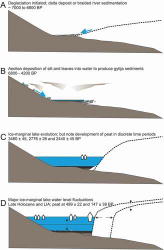
Our date of 3480 ± 45 cal. yr BP for roots and leaves in the ice-dammed lake basin that were subsequently buried in lake water and our date of 3944 ± 38 cal. yr BP in the Isunnguata Sermia lake basin both demand a substantial period of time beforehand for those roots, leaves, and peat, respectively, to accumulate in the (then virtually empty) lake basins (). Those timings coincide with the first of two pronounced episodes of aeolian deposition that Willemse et al. (Citation2002) reported as being between 4900 and 3500 cal. yr BP. Those dates also agree with the suggested onset of “additional and proximal glacifluvial sedimentary systems,” so presumably with glacial expansion approximately 4000 cal. yr BP (Anderson et al. Citation1999). After this time period, formation of the gyttja deposits evidences submergence beneath standing water of that organic material and thus lake formation (). Ponding of water at this time is perhaps difficult to explain, because normally the lake is ice dammed. We therefore tentatively suggest that the lake within which the lower gyttja deposits were formed was shallow and impounded by the delta or braided-river gravels. We have no evidence of a (recessional) moraine ridge across the mouth of the lake basin (the contemporary ice margin), but it is perfectly plausible that one existed there during early Holocene deglaciation.
The boulder-rich layer, which formed by calving icebergs between 3480 ± 45 cal. yr BP and 2776 ± 26 cal. yr BP, indicates that the mid-Holocene (neoglacial) position of the ice-sheet margin at Russell Glacier must have been close to its LIA maximum. Assuming that the minimum Holocene ice-sheet extent occurred later than 5000 cal. yr BP and the maximum distance from the present-day margin was tens of kilometers inland (Kaufman et al. Citation2004; Simpson et al. Citation2009; van Tatenhove, van der Meer, and Koster Citation1996; Young and Briner Citation2015), the early neoglacial advance of the ice-sheet margin must therefore have progressed at a mean advance rate of at least 5–20 m yr−1. Unfortunately, we are not able to provide more quantitative detail on the most inland position of the ice margin during the mid-late Holocene.
In contrast, the temporal evolution of the ice margin is now better constrained by the data presented within this article. Specifically, documentation of two layers of organic material at 0.92 m depth and 1.20 m depth of late-Holocene age (2440 ± 45 cal. yr BP and 2776 ± 26 cal. yr BP, respectively) improves the geochronological resolution of knowledge of the ice-margin dynamics at this time. They both reveal the timing of periods without an ice-dammed lake present, and thus of a relatively diminished ice mass, that were sufficiently long enough for vegetation growth to occur within the lake basin ().
In comparison, Young and Briner (Citation2015) concluded that between approximately 4200 cal. yr BP and 1800 cal. yr BP the ice margin was more than 900 m inland of the contemporary position. Forman et al. (Citation2007) concluded that a neoglacial ice advance at approximately 2000 cal. yr BP was probably of similar magnitude as the LIA maximum. To reconcile our ages of a drained lake state with the age of a neoglacial ice advance suggested by Forman et al. (Citation2007), it must be considered that significant ice-margin advances and retreats in this location occur rapidly—hundreds of meters at least and within just a few centuries at most. Very recent work by Larsen et al. (Citation2017) in southwest Greenland has highlighted that the GrIS response to neoglacial cooling was strongly controlled by altitude. They evidence regrowth of glaciers at approximately 5500 cal. yr BP BP at approximately 1,370 m a.s.l., 3600 cal. yr BP at 1,170 m a.s.l., and approximately 1600 cal. yr BP at 1,000 m a.s.l. We find that Russell Glacier has apparently advanced to form its ice-marginal ice-dammed lake (situated at 420 m a.s.l.) at approximately 4000 cal. yr BP, and between 2776 ± 26 cal. yr BP and 2440 ± 45 cal. yr BP.
The formation of the lower peat layer (2776 ± 26 cal. yr BP) evidences a period of ice recession, followed by ice advance between 2776 ± 26 cal. yr BP and 2440 ± 45 cal. yr BP. From 2440 ± 45 cal. yr BP to 499 ± 22 cal. yr BP, glaciolacustrine facies indicate a several millennia period during which the ice margin must have been located close to the LIA maximum, although the two intercalated thin peat layers show some variability in local glacier mass balance during this time.
Our identification of young (147 ± 39 cal. yr BP, 499 ± 22 cal. yr BP) organic material in the main ice-dammed lake basin (and of 245 ± 26 cal. yr BP in the Isunnguata Sermia lake basin) is novel. Because this organic material is of an age corresponding to the latter part of the LIA (Forman et al. Citation2007), they are at first glance inconsistent with what would be expected during a time of general ice expansion. That is because for peat to form the lake must have been drained for a sufficient period of time for peat to accumulate and thus the ice must have been relatively diminished in comparison to that at present (). However, while we caution that the age uncertainty is quite large on these samples, we also note that Forman et al. (Citation2007) remarked on the geomorphological evidence for an LIA ice expansion in the Russell Glacier–Isunnguata Sermia area being of a complex pattern and indicative of considerable spatial variability. Weidick (Citation1968, Citation1991) mentioned this variability of land-terminating parts of the ice sheet, and it has been somewhat quantified more recently by Larsen et al. (Citation2017) and Levy et al. (Citation2017) for sites in southwest Greenland.
Nonetheless, both of the lake basins we sampled in this study have very similar ages for the most recent period of peat accumulation. Local variability has to be because of local factors and, arguably, our recognition of peat layers sheds light on the nature of these local factors. Most importantly, the ice sheet in this area has to advance up a topographically reverse slope. That setting facilitates meltwater to be ponded at the ice margin within ice-dammed lakes and to likely persist subglacially too. The presence/absence and drainages of these ice-marginal lakes must surely affect local ice-margin dynamics (Carrivick and Tweed Citation2013).
Therefore, the simplest explanation to resolve our late-Holocene-dated peat layers against the literature is that the ice-sheet margin at Russell Glacier receded before 499 ± 22 cal. yr BP, perhaps as a consequence of the warm Medieval Climate Anomaly from 1200 to 1000 cal. yr BP, which is observed in Greenland ice-core records (Dahl-Jensen et al. 1998). This ice-margin recession was followed by the LIA advance, which apparently reached its maximum extent at Russell Glacier after 147 ± 39 cal. yr BP. At Isunnguata Sermia, the LIA maximum may have been reached as early as 245 ± 26 cal. yr BP.
During the twentieth century, the position of the ice-sheet margin has stabilized, with only minor variations (Knight et al. Citation2000, Citation2007), but after AD 1995–1998 the marginal area of the ice sheet has rapidly thinned (Krabill et al. Citation1999), leading to lake drainage and jökulhlaups (Russell et al. Citation2011).
Conclusions
While lacustrine-terminating glaciers can be partially decoupled from climate, the identification of Holocene geological records of the drainage of ice-dammed lakes must imply glacier ice-margin recession or ice-dam thinning. This study has demonstrated the utility of the sedimentary archives within ice-dammed lake basins that can contain information about the position of ice-sheet margin and, by inference, of local glacier mass balance. That information can evidently be relatively detailed in comparison to that from the dating of moraine ridges, for example.
In summary, the ice margin in the vicinity of Kangerlussuaq, at Russell Glacier and Isunnguata Sermia, retreated from the topographic basin(s) that are now occupied by ice-dammed lakes approximately 7,000–6800 cal. yr BP. We have suggested that the Russell Glacier lake basin subsequently received relatively coarse-grained glacifluvial sediment predominantly from an ice-marginal delta and/or a proglacial, braided river. Aeolian activity deposited silt and leaves, and some vegetation (roots) developed in the basin. Ponding of (probably hillslope runoff) water formed organic-rich gyttja sediments and thin layers of peat up to approximately 4200 cal. yr BP. The lake then became ice marginal and received suspended sediment and drop stones from calving icebergs. This ice-marginal lake has persisted throughout the late Holocene. Ice advances are interpreted to have occurred at approximately 4000 cal. yr BP, and between 2776 ± 26 cal. yr BP and 2440 ± 45 cal. yr BP. The LIA advance at Russell Glacier apparently reached its maximum extent after 147 ± 39 cal. yr BP, whereas at Isunnguata Sermia the LIA maximum may have been reached as early as 245 ± 26 cal. yr BP. The Russell Glacier lake has been drained for sufficiently long time periods for peat layers to accumulate (i.e., time periods of major ice-margin recession have occurred) at 3480 ± 45 cal. yr BP, 2776 ± 26 cal. yr BP, 2440 ± 45 cal. yr BP, 499 ± 22 cal. yr BP, and 147 ± 39 cal. yr BP. The Isunnguata Sermia lake basin was drained sufficiently long enough for organic material accumulation at 245 ± 26 cal. yr BP.
The wider significance of this study is that at present, land-terminating parts of the west GrIS margin are becoming progressively more lacustrine terminating (Carrivick and Quincey Citation2014). Understanding how this ongoing transition will affect local and regional GrIS dynamics in the future will probably require numerical models of ice-flow dynamics to include lacustrine-terminating processes. These types of models would ideally be developed with contemporary field data for parameterization and for validation, but such field data are extremely sparse. Therefore, improved temporal resolution of geological reconstructions of lake and ice-margin dynamics and interactions, such as within this study, will be important both for numerical models that attempt to assess ice extent throughout the Holocene (Simpson et al. Citation2009; Young and Briner Citation2015) and for models considering the future evolution of the GrIS.
Acknowledgments
We thank Jan Heinemeier, Jesper Olsen, and Ann Berith Jensen at the Aarhus AMS Centre (AARAMS) for conducting the radiocarbon datings. We also appreciate the logistic support, which we received from Kangerlussuaq International Science Support (KISS).
References
- Aebly, F. A., and S. C. Fritz. 2009. Palaeohydrology of Kangerlussuaq (Søndre Strømfjord), west Greenland during the last ~8000 years. The Holocene 19:1–11. doi:https://doi.org/10.1177/0959683608096601.
- Anderson, N. J., J. E. Saros, J. E. Bullard, S. M. P. Cahoon, S. McGowan, E. A. Bagshaw, C. D. Barry, R. Bindler, B. T. Burpee, J. L. Carrivick, et al. 2017. The Arctic in the twenty-first century: Changing biogeochemical linkages across a paraglacial landscape of Greenland. Bioscience 67 (2):118–33.
- Anderson, N. J., O. Bennike, K. Christoffersen, E. Jeppesen, S. Markager, G. Miller, and I. Renberg. 1999. Limnological and paleolimnological studies in southwestern Greenland. Geology of Greenland Survey Bulletin 183:68–74.
- Anderson, N. J., and M. J. Leng. 2004. Increased aridity during the early Holocene in west Greenland inferred from stable isotopes in laminated-lake sediments. Quaternary Science Reviews 23:841–49. doi:https://doi.org/10.1016/j.quascirev.2003.06.013.
- Bamber, J. L., J. A. Griggs, R. T. W. L. Hurkmans, J. A. Dowdeswell, S. P. Gogineni, I. Howat, J. Mouginot, J. Paden, S. Palmer, E. Rignot, et al. 2013. A new bed elevation dataset for Greenland. The Cryosphere 7 (2):499–510. doi:https://doi.org/10.5194/tc-7-499-2013.
- Bennike, O., and S. Björck. 2002. Chronology of the last recession of the Greenland Ice Sheet. Journal of Quaternary Science 17:211–19. doi:https://doi.org/10.1002/jqs.670.
- Bennike, O., B. Wagner, and A. Richter. 2011. Relative sea level changes during the Holocene in the Sisimiut area, south-western Greenland. Journal of Quaternary Science 26:353–61. doi:https://doi.org/10.1002/jqs.1458.
- Bullard, J. E., and M. J. Austin. 2011. Dust generation on a proglacial floodplain, West Greenland. Aeolian Research 3:43–54. doi:https://doi.org/10.1016/j.aeolia.2011.01.002.
- Carlson, A. E., K. Winsor, D. J. Ullman, E. J. Brook, D. H. Rood, Y. Axford, A. N. LeGrande, F. S. Anslow, and G. Sinclair. 2014. Earliest Holocene south Greenland ice sheet retreat within its late Holocene extent. Geophysical Research Letters 41:1–8. doi:https://doi.org/10.1002/2014GL060800.
- Carrivick, J. L., A. G. Turner, A. J. Russell, T. Ingeman-Nielsen, and J. C. Yde. 2013. Outburst flood evolution at Russell Glacier, western Greenland: Effects of a bedrock channel cascade with intermediary lakes. Quaternary Science Reviews 67:39–58. doi:https://doi.org/10.1016/j.quascirev.2013.01.023.
- Carrivick, J. L., and F. S. Tweed. 2013. Proglacial lakes: Character, behaviour and geological importance. Quaternary Science Reviews 78:34–52. doi:https://doi.org/10.1016/j.quascirev.2013.07.028.
- Carrivick, J. L., and D. J. Quincey. 2014. Progressive increase in number and volume of ice-marginal lakes on the western margin of the Greenland Ice Sheet. Global and Planetary Change 116:156–63. doi:https://doi.org/10.1016/j.gloplacha.2014.02.009.
- Carrivick, J. L., J. Yde, A. J. Russell, D. J. Quincey, T. Ingeman‐Nielsen, and J. Mallalieu. 2016. Ice‐margin and meltwater dynamics during the mid‐Holocene in the Kangerlussuaq area of west Greenland. Boreas 46:369–87. doi:https://doi.org/10.1111/bor.12199.
- Carrivick, J. L., F. Tweed, F, Ng, D. Quincey, J. Mallalieu, T. Ingeman-Nielsen, A. Mikkelsen, S. Palmer, J. Yde, R. Homer, A. and Russell. 2017. Ice-dammed lake drainage evolution at Russell Glacier, west Greenland. Frontiers in Earth Science 5: 100.
- Dahl-Jensen, D., K. Mosegaard, N. Gundestrup, G. D. Clow, S. J. Johnsen, A. W. Hansen, and N. Balling. 1998. Past temperatures directly from the Greenland ice sheet. Science 282 (5387):268–71.
- Dijkmans, J. W. A., and T. E. Törnqvist. 1991. Modern periglacial eolian deposits and landforms in the Søndre Strømfjord area, West Greenland and their palaeoenvironmental implications. Meddelelser Om Grønland Geoscience 25:3–39.
- Eisner, W. R., T. E. Törnquist, E. A. Koster, O. Bennike, and J. F. N. van der Leeuwen. 1995. Paleoecological studies of a Holocene lacustrine record from the Kangerlussuaq (Søndre Strømfjord) Region of West Greenland. Quaternary Research 43:55–66. doi:https://doi.org/10.1006/qres.1995.1006.
- Forman, S. L., L. Marín, C. van der Veen, C. Tremper, and B. Csatho. 2007. Little ice age and neoglacial landforms at the Inland Ice margin, Isunnguata Sermia, Kangerlussuaq, west Greenland. Boreas 36:342–51. doi:https://doi.org/10.1080/00173130601173301.
- Funder, S., and L. Hansen. 1996. The Greenland ice sheet: A model for its culmination and decay during and after the last glacial maximum. Bulletin of the Geological Society of Denmark 42:137–52.
- Gordon, J. E. 1986. Correspondence: Glacial lake drainage near Søndre Strømfjord, West Greenland. Journal of Glaciology 31 (111):304. doi:https://doi.org/10.1017/S0022143000015641.
- Kaufman, D., T. Ager, N. Anderson, P. Anderson, J. Andrews, P. Bartlein, L. Brubaker, L. Coats, L. C. Cwynar, and M. Duvall. 2004. Holocene thermal maximum in the western Arctic (0-180 W). Quaternary Science Reviews 23:529–60. doi:https://doi.org/10.1016/j.quascirev.2003.09.007.
- Knight, P. G., C. E. Jennings, R. I. Waller, and Z. P. Robinson. 2007. Changes in ice margin processes and sediment routing during ice-sheet advance across a marginal moraine. Geografiska Annaler 89A (3):203–15. doi:https://doi.org/10.1111/j.1468-0459.2007.00319.x.
- Knight, P. G., R. I. Waller, C. J. Patterson, A. P. Jones, and Z. P. Robinson. 2000. Glacier advance, ice-marginal lakes and routing of meltwater and sediment: Russell Glacier, Greenland. Journal of Glaciology 46 (154):423–26. doi:https://doi.org/10.3189/172756500781833160.
- Krabill, W., E. Frederick, S. Manizade, C. Martin, J. Sonntag, R. Swift, R. Thomas, W. Wright, and J. Yungel. 1999. Rapid thinning of parts of the southern Greenland Ice Sheet. Science 283:1522–24. doi:https://doi.org/10.1126/science.283.5407.1522.
- Larsen, N. K., A. Strunk, L. B. Levy, J. Olsen, A. Bjørk, T. L. Lauridsen, E. Jeppesen, and T. A. Davidson. 2017. Strong altitudinal control on the response of local glaciers to Holocene climate change in southwest Greenland. Quaternary Science Reviews 168:69–78. doi:https://doi.org/10.1016/j.quascirev.2017.05.008.
- Leuschen, C. 2013. IceBridge MCoRDS L1B geolocated radar echo strength profiles. NASA DAAC at the National Snow and Ice Data Centre, Boulder, Colorado.
- Levy, L., M. A. Kelly, J. A. Howley, and R. A. Virginia. 2012. Age of the Ørkendalen moraines, Kangerlussuaq, Greenland: Constraints on the extent of the southwestern margin of the Greenland Ice Sheet during the Holocene. Quaternary Science Reviews 52:1–5. doi:https://doi.org/10.1016/j.quascirev.2012.07.021.
- Levy, L. B., N. K. Larsen, T. A. Davidson, A. Strunk, J. Olsen, and E. Jeppesen. 2017. Contrasting evidence of Holocene ice margin retreat, south‐western Greenland. Journal of Quaternary Science 32:604–16. doi:https://doi.org/10.1002/jqs.v32.5.
- Mernild, S. H., and B. Hasholt. 2009. Observed runoff, jökulhlaups and suspended sediment load from the Greenland ice sheet at Kangerlussuaq, West Greenland, 2007 and 2008. Journal of Glaciology 55 (193):855–58.
- Mernild, S. H., B. Hasholt, D. L. Kane, and A. C. Tidwell. 2008. Jökulhlaup observed at Greenland ice sheet. Eos, Transactions American Geophysical Union 89 (35):321–22.
- Mikkelsen, A. B., B. Hasholt, N. T. Knudsen, and M. H. Nielsen. 2013. Jökulhlaups and sediment transport in Watson River, Kangerlussuaq, west Greenland. Hydrology Research 44 (1):58–67. doi:https://doi.org/10.2166/nh.2012.165.
- Palmer, S., A. Shepherd, P. Nienow, and I. Joughin. 2011. Seasonal speedup of the Greenland Ice Sheet linked to routing of surface water. Earth and Planetary Science Letters 302 (3–4):423–28. doi:https://doi.org/10.1016/j.epsl.2010.12.037.
- Reimer, P. J., E. Bard, A. Bayliss, J. W. Beck, P. G. Blackwell, C. B. Ramsey, C. E. Buck, H. Cheng, R. L. Edwards, M. Friedrich, et al. 2013. IntCal13 and Marine13 radiocarbon age calibration curves, 0–50,000 years cal BP. Radiocarbon 55 (4):1869–87. doi:https://doi.org/10.2458/azu_js_rc.55.16947.
- Renssen, H., H. Seppä, X. Crosta, H. Goosse, and D. Roche. 2012. Global characterization of the Holocene thermal maximum. Quaternary Science Reviews 48:7–19. doi:https://doi.org/10.1016/j.quascirev.2012.05.022.
- Rinterknecht, V., Y. Gorokhovich, J. Schaeffer, and M. Caffee. 2009. Preliminary 10Be chronology for the last deglaciation of the western margin of the Greenland Ice Sheet. Journal of Quaternary Science 24 (3):270–78. doi:https://doi.org/10.1002/jqs.1226.
- Russell, A. J. 1989. A comparison of two recent jökulhlaups from an ice-dammed lake, Søndre Strømfjord, West Greenland. Journal of Glaciology 35 (120):157–62. doi:https://doi.org/10.3189/S0022143000004433.
- Russell, A. J., J. L. Carrivick, T. Ingeman-Nielsen, J. C. Yde, and M. Williams. 2011. A new cycle of jökulhlaups at Russell Glacier, Kangerlussuaq, west Greenland. Journal of Glaciology 57 (202):238–46. doi:https://doi.org/10.3189/002214311796405997.
- Russell, A. J., and C. De Jong. 1989. Lake drainage mechanisms for the ice-dammed Oberer Russellsee, Søndre Strømfjord, West Greenland. Zeitschrift Für Gletscherkunde and Glazialgeologi 24 (2):143–47.
- Scholz, H., B. Schreiner, and H. Funk. 1988. Der einflussvon gletscherläufen auf die schemlzwasserablagerungen des Russell-Gletschers bei Söndre Ströfjord (West Grönland). Zeitschrift Für Gletscherkunde and Glazialgeologi 24 (1):55–74.
- Simpson, M. J. R., G. A. Milne, P. Huybrechts, and A. J. Long. 2009. Calibrating a glaciological model of the Greenland ice sheet from the last glacial maximum to present-day using field observations of relative sea level and ice extent. Quaternary Science Reviews 28:1631–57. doi:https://doi.org/10.1016/j.quascirev.2009.03.004.
- Storms, J. E., I. L. de Winter, I. Overeem, G. G. Drijkoningen, and H. Lykke-Andersen. 2012. The Holocene sedimentary history of the Kangerlussuaq Fjord-valley fill, West Greenland. Quaternary Science Reviews 35:29–50. doi:https://doi.org/10.1016/j.quascirev.2011.12.014.
- Sugden, D. E., C. M. Clapperton, and P. G. Knight. 1985. A jökulhlaup near Søndre strømfjord, West Greenland, and some effects on the ice-sheet margin. Journal of Glaciology 31 (109):366–68. doi:https://doi.org/10.1017/S0022143000006729.
- Ten Brink, N. W. 1975. Holocene history of the Greenland ice-sheet based on radiocarbon dated moraines in West Greenland. Meddelelser Om Grønland 201:44p.
- Ten Brink, N. W., and A. Weidick. 1974. Greenland ice sheet history since the last glaciation. Quaternary Research 4 (4):429–40. doi:https://doi.org/10.1016/0033-5894(74)90038-6.
- van Tatenhove, F. G. M., J. J. M. van der Meer, and E. A. Koster. 1996. Implications of deglaciation chronology from new AMS age determinations in central west Greenland. Quaternary Research 45:245–53. doi:https://doi.org/10.1006/qres.1996.0025.
- Weidick, A. 1968. Observations on some Holocene glacier fluctuations in west Greenland. Meddelelser om Grènland 165:1–202.
- Weidick, A. 1991. Present-day expansion of the southern part of the Inland Ice. Rapport Grønlands Geologiske Undersøgelse 152:73–79.
- Willemse, N.W. 2002. Holocene sedimentation history of the shallow Kangerlussuaq lakes, west Greenland (Vol. 4). Danish Polar Center.
- Yde, J. C., N. T. Knudsen, B. Hasholt, and A. B. Mikkelsen. 2014. Meltwater chemistry and solute export from a Greenland Ice Sheet catchment, Watson River, west Greenland. Journal of Hydrology 519:2165–79. doi:https://doi.org/10.1016/j.jhydrol.2014.10.018.
- Young, N. E., and J. P. Briner. 2015. Holocene evolution of the western Greenland Ice Sheet: Assessing geophysical ice-sheet models with geological reconstructions of ice margin change. Quaternary Science Reviews 114:1–17. doi:https://doi.org/10.1016/j.quascirev.2015.01.018.
- Young, N. E., J. P. Briner, D. H. Rood, R. C. Finkel, L. B. Corbett, and P. R. Bierman. 2013. Age of the Fjord Stade moraines in the Disko Bugt region, western Greenland, and the 9.3 and 8.2 ka cooling events. Quaternary Science Reviews 60:76–90. doi:https://doi.org/10.1016/j.quascirev.2012.09.028.