
ABSTRACT
Little is known about the presence, distribution, age, or activity of rock glaciers in the British Columbia Coast Mountains of western Canada. Reflecting debris accumulation and mass wasting under a periglacial climate, these rock glaciers describe a geomorphic response to permafrost regimes that may or may not presently exist. An inventory of rock glacier landforms in the eastern front ranges of the Coast Mountains, using high-resolution Google Earth imagery, documented 165 rock glaciers between lat. 50°10ʹ and 52°08ʹ N. The majority of these rock glaciers occur at sites positioned between 1,900 and 2,300 m above sea level, where rain shadow effects and continental air masses result in persistent dry, cold conditions. Morphology and field observation suggest that these features contain intact ice. The rock glaciers occupy predominately northwest- to northeast-facing slopes, with talus-derived rock glaciers largely restricted to north-facing slopes. Glacier-derived features outnumber talus-derived features by a ratio of 5:1. Several of the inventoried rock glaciers were located up valley from presumed Younger Dryas terminal moraines, indicating that they formed after 9390 BP. Dendrogeomorphological investigations at one rock glacier record contemporary activity that resulted in 1.3 cm/yr of frontal advance since AD 1674. This inventory is the first to document the presence of rock glaciers in the Coast Mountains and supports preliminary understandings of permafrost distribution in the southwestern Canadian Cordillera.
Introduction
The British Columbia Coast Mountains flank the Pacific coast of western Canada, rising from sea level to more than 4,000 m in the Mt. Waddington area (). Along their windward maritime slopes, deep winter snow packs persist into the summer months, allowing for the development of high-elevation ice fields and large valley glaciers. Eastward glaciers decrease in size and number, because strong rain shadow effects result in a subcontinental environment in the front ranges abutting the Chilcotin Plateau. While ice fields are absent in the front ranges and glaciers are largely restricted to shaded northeast-facing high-elevation cirques (Falconer, Henoch, and Østrem Citation1965; Østrem Citation1966; Østrem and Arnold Citation1970), satellite imagery shows that rock glaciers of varying size and morphology are abundant.
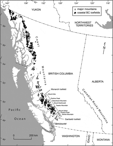
Figure 1. Map of British Columbia, Canada, showing the location of the front ranges study area. Mountain peaks are provided for geographic reference
Little is known about the presence, distribution, age, or activity of rock glaciers in the Coast Mountains (French and Slaymaker Citation1993). Reflecting debris accumulation and mass wasting under a periglacial climate (Haeberli et al. Citation2006; Humlum Citation2000), their occurrence describes a geomorphic response to permafrost thermal regimes that may or may not presently exist (Humlum Citation1998). While a provisional map suggests that much of the region is currently favorable for the development and persistence of permafrost (Hasler, Geertsma, and Hoelzle Citation2014), it remains to be determined whether these landforms are the fossilized remains of rock glaciers active during Late Pleistocene or Holocene permafrost conditions or whether they illustrate a geomorphic response to present-day permafrost environments.
The intent of this research was to document the distribution and general characteristics of rock glaciers in the southeastern front ranges of the Coast Mountains. We hypothesized that the spatial and altitudinal distribution of rock glaciers in this region would allow for interpretation of their paleohistory in the context of Holocene climatic variability, and would allow for further understanding of the present-day occurrence of permafrost within this setting. To achieve these objectives, the characteristics of a large sample of rock glaciers from the region are compared to regional climatic gradients and topographic conditions. Dendrochronology was used at one rock glacier site to gain an understanding of contemporary rock glacier geomorphology.
Research background
The term rock glacier is associated with a range of landform types found in arctic and alpine environments (Janke et al. Citation2013). By definition, rock glaciers consist of perennially frozen masses of ice and debris that creep downslope under the weight of gravity (Barsch Citation1996; Haeberli Citation1985; Haeberli et al. Citation2006). Transverse ridges and longitudinal furrows are the surface expression of this internal ice deformation (Barsch Citation1996; Frehner, Ling, and Gärtner-Roer Citation2014).
The surface of most rock glaciers consists of a seasonally thawed active layer characterized by angular boulders and large interstitial spaces. This debris mantle acts as a filter between external climatic conditions and the permanently frozen interior below the permafrost table (Haeberli et al. Citation2006; Humlum Citation1996; Wahrhaftig and Cox Citation1959). Cold, dense air settles in the interstitial spaces between the rocks and cools the permafrost despite short-term surface fluctuations in snow cover and above 0°C air temperatures (Humlum Citation1997). Rock glaciers, therefore, provide evidence of the lower extent of permafrost because of their ability to maintain a frozen state despite the general trend of warmer mean annual air temperatures at lower elevations (Boeckli et al. Citation2012; Lilleøren and Etzelmuller Citation2011; Lilleøren et al. Citation2013a; Scotti et al. Citation2013).
In high mountain regions, rock glaciers commonly form at sites characterized by cool air temperatures and moderate amounts of precipitation (Haeberli Citation1985; Humlum Citation1998). While rock glaciers are occasionally found in maritime climate regions (Humlum Citation1982; Lilleøren et al. Citation2013a; Martin and Whalley Citation1987), their distribution is largely restricted to continental climate zones. Rain shadow conditions are ideal for rock glacier formation, as the thin mountain snowpack that characterizes many of these regions reduces insulation, allowing cold winter air temperatures to sustain negative ground temperatures (Haeberli et al. Citation2006; Humlum Citation1997). In mountainous settings rock glaciers are most commonly located were shading shields them from insolation and the local topography directs cold winds down into the debris layer (Humlum Citation1997, Citation1998).
Previous descriptions of rock glaciers in the western Canadian Cordillera focus on those found in the southern Canadian Rocky Mountains in Alberta (Bachrach et al. Citation2004; Carter et al. Citation1999; Gardner Citation1978; Koning and Smith Citation1999; Luckman and Crockett Citation1978; Osborn Citation1975), as well as in the St. Elias and Selwyn Mountains in Yukon (Johnson Citation1978, 1980; Sloan and Dyke Citation1998). The majority of rock glaciers in the southern Canadian Rocky Mountains are located in high-elevation, north-facing cirques where the local lithology exerts a strong control on their form and presence. In that area, rock glaciers are common in the shales and quartzites of the Main Ranges, but are sparse in the shales and carbonates of the Front Ranges (Luckman and Crockett Citation1978). Most of these rock glaciers are believed to have developed following the retreat of the Cordilleran Ice Sheet at the end of the Pleistocene, although absolute origin ages have not been assigned (Johnson Citation1978; Luckman and Crockett Citation1978).
Study area
The study area for this research includes the southeastern Coast Mountain Front Ranges from east of the Garibaldi Icefield (lat. 50°10ʹ N) to terrain northwest of the Monarch Icefield (lat. 52°08ʹ N; ). The region is south of the continuous permafrost limit in western Canada but is assumed to contain isolated patches of permafrost (up to 10%) at the highest altitudes (Brown and Péwé Citation1973; Hasler, Geertsma, and Hoelzle Citation2014; Heginbottom, Dubreuil, and Harker Citation1995; Rodenhuis et al. Citation2007). Mean annual air temperatures (1969–1990) range between −5°C and 0°C at the highest elevations on the lee side of the range, with precipitation totals averaging 750 mm/yr or greater (Dawson, Werner, and Murdock Citation2008).
The region is located within the Coast Mountain Belt, a major tectonic feature located between the Insular and Intermontane superterranes of western British Columbia that were accreted along the continental margin from Middle Jurassic to Early Cretaceous time (Journeay and Friedman Citation1993). Deformation and contraction resulted in the deposition of preexisting terranes into metamorphosed thrust sheets intruded with plutons (Bustin et al. Citation2013; Journeay and Friedman Citation1993; Monger and Journeay Citation1994). Pockets of volcanic and sedimentary rocks not consumed by the intrusion remain throughout the region, particularly along the eastern border of the Yalakom fault where they are separated from the neighboring Intermontane Belt (Massey et al. Citation2005).
Following degradation and downwasting of the Cordilleran Ice Sheet and a Late Pleistocene glacial advance in 10.7–10.5 ka (Grubb Citation2006; Margold et al. Citation2013), by 10.0 ka glaciers in the study area had retreated several kilometers upvalley to rarely expand beyond their mountain-front terminal positions through the Holocene (Menounos et al. Citation2009; Mood and Smith 2015). Intervals of cooler/wetter and warmer/drier climates resulted in only minor ice-front oscillations during the Holocene, at least until the last millennia when Little Ice Age (LIA) climate changes (Larocque and Smith Citation2005a; Steinman et al. Citation2014) initiated a period of sustained glacier expansion (Larocque and Smith Citation2005b; Wood, Smith, and Demuth Citation2011). In the last century rising air temperatures and variable snowpacks (Dawson, Werner, and Murdock Citation2008) have resulted in negative mass-balance conditions and significant volumetric losses of glacier ice (Bolch, Menounos, and Wheate Citation2010; Schiefer, Menounos, and Wheate Citation2007; VanLooy and Forster Citation2008). Within the study area, many of the cirque glaciers active during the LIA have melted entirely, and a thick cover of rockfall debris mantles the surface of those that remain.
Methods and data
Rock glacier classification
The rock glacier inventory was completed using high-resolution Google Earth satellite imagery (2004/2005). Google Earth was previously used for rock glacier identification in the Bolivian Andes and the Hindu Kush-Himalayan region (Rangecroft et al. Citation2014; Schmid et al. Citation2014), and in the Coast Mountains it represents the best available imagery for detecting rock glaciers across large spatial areas. Google Earth uses SPOT or products from DigitalGlobe (e.g., IKONOS or Quickbird) that have a spatial resolution close to that of aerial photographs (Schmid et al. Citation2014). The application geo-rectifies the imagery onto a Digital Terrain Model with an accuracy of up to ±90 m (Rusli, Majid, and Din Citation2014). Only snow-free and cloud-free imagery was used in the survey, and identification was supplemented with field validation where access permitted.
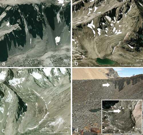
Rock glaciers were categorized based on genesis and ice presence. It is widely accepted that rock glaciers are transitional features, oftentimes marking the interaction between ice of mixed glacial and periglacial origin (Haeberli et al. Citation2006; Monnier and Kinnard Citation2015). For this reason, we used a classification scheme that distinguishes between rock glaciers predominately influenced by slope dynamics, such as rock falls and slides (talus-derived; ), and those related to glacial dynamics (glacier-derived; and ). Talus-derived rock glaciers originate from talus slopes directly attached to headwalls (Barsch Citation1996; Haeberli Citation1985; Haeberli et al. Citation2006; Humlum Citation1984); these are often referred to as “true rock glaciers” in the literature (e.g., Clark et al. Citation1998). Within the glacier-derived category, two forms are present: (1) rock glaciers originating from glacial debris, such as lateral and terminal moraine deposits ()—these features satisfy Barsch’s (Citation1996) classification of “debris rock glaciers” and are comparable to those detailed in previous moraine-derived classification schemes (Lilleøren and Etzelmuller Citation2011; Lilleøren et al. Citation2013a)—and (2) rock glaciers that are visually connected to glaciers but lack a defined boundary between the glacier ice and the rock glacier below (). The upper sections of these rock glaciers often contain thermokarst thaw pits or are characterized by a depression between the mountainside and the rock glacier deposit. Humlum (Citation1996, Citation1997) describes similar features in western Greenland, arguing that despite the similarity to glaciers these features display active-layer dynamics and should be termed permafrost landforms. Similar features have been documented in Wyoming (Clark et al. Citation1998), the Andes of central Chile (Brenning Citation2005), and in the French Alps (Monnier et al. Citation2013). The glacier-derived category of rock glaciers includes landforms influenced by glacial activity more broadly, but does not make the claim that these features are of a glacigenic origin (e.g., Berthling Citation2011; Clark et al. Citation1998). Massive ice was confirmed at one of the rock glaciers included in our inventory (), supporting the applicability of the glacier-derived classification scheme in this setting.
Figure 2. Rock glacier classification: (a) intact talus-derived (ID #98); (b) intact glacier-derived, type A (ID #109); (c) intact glacier-derived, type B (ID #26); and (d) massive ice at Razorback Peak (ID #87). Numbers provided refer to rock glacier ID (see )
In an effort to avoid inferring activity from morphology (Berthling Citation2011), this research considered intact rock glaciers as those containing ice and relict forms as those with ice no longer present (Haeberli Citation1985). Only rock glaciers with apparent intact morphology were considered in this study because of the limitations of objective classification without on-the-ground observation. An intact rock glacier was identified as a feature with a steep front at or near the angle of repose with a collection of spilled boulders commonly found in the foreground, indicating surface transport (Barsch Citation1996; Haeberli Citation1985). Internal deformation was apparent from ridge/furrow morphology along the surface, and material sorting was visible at the front and sides (). Vegetation was not used as an indicator because vegetation has been shown to be present on both intact and relict features (Haeberli Citation1985; Sorg et al. 2015). While landforms with flatter, thinner fronts and minimal front angles were observed in the study area, these features were not classified as relict. We recognized that shadowing or image resolution could be responsible for the different toe appearance, and direct evidence would be required before these forms could be included in the regional inventory. Furthermore, these features did not appear to be significantly different from intact features in their altitude, aspect, or environmental conditions.
Rock glacier mapping and analysis
The lowermost point of a rock glacier (e.g., toe) was chosen as a discrete boundary between the rock glacier and the surrounding terrain in order to reduce subjectivity in the mapping process. In the case of many glacier-derived rock glaciers, the boundary between glacier, debris-covered ice, and rock glacier was unclear. To prevent an inaccurate estimation of rock glacier extent, the rock glacier toe was used as the best first estimate of rock glacier presence in an area. Additional field reconnaissance would have been necessary to classify many of the transitional features visible in the imagery.
The topographic and climatic characteristics of the rock glaciers identified in the inventory were recorded in a Geographical Information System (GIS) environment (ArcMap 10.0). The coordinate of each rock glacier toe was joined with elevation and aspect layers derived from the Canadian Digital Elevation Model at a resolution of 50 m (Geogratis Citation2013). In the case of rock glaciers with multiple tongues, the tongue with the lowest elevation was used to obtain a toe coordinate. A digital version of the Geological Map of British Columbia from the British Columbia Ministry of Energy and Mines (1:250,000; Massey et al. Citation2005) was added to the rock glacier location data to include rock class within the spatial database. Mean annual air temperature (MAAT) and mean annual precipitation (MAP; 1971–2000) data were obtained for each rock glacier toe using ClimateBC (v. 5.04) interpolated weather-station data (Spittlehouse and Wang Citation2014; Wang et al. Citation2012). ClimateBC calculates a lapse rate specific to the spatial location, elevation, and variable of interest to produce a scale-free estimate of climatic conditions (Wang et al. Citation2012).
Environmental conditions were summarized for glacier-derived and talus-derived rock glaciers. Average and standard deviation values were calculated to characterize the populations, followed by pairwise comparisons using the Kruskal-Wallis one-way analysis of variance by ranks for nonparametric data to identify statistically significant differences between categories. All statistical calculations were completed using the software environment R (v. 3.1.2). Circular plots were used to determine the relative spread or concentration of slope aspect across rock glacier categories.
Estimating thermal regimes
In the absence of ground-temperature data from the study area, the spatial distribution of rock glaciers was compared to the location of glaciers and to the position of the upper treeline to estimate the altitudinal extent of periglacial activity (e.g., French and Slaymaker Citation1993; Harris and Brown Citation1981). An inverse relationship was assumed to exist between the lower limit of permafrost and the altitude of glaciers (French and Slaymaker Citation1993). In most cases, where heavy snowfall results in low-lying glaciers near the treeline, the ground is insulated from perennial freezing, and permafrost is restricted to the highest elevations. Conversely, in continental regions with less precipitation, glaciers form at higher elevations. Permafrost often occurs between the lower limits of glaciation and the contemporary treeline, where the forest cover enhances snow accumulation and insulates the ground (French and Slaymaker Citation1993).
To facilitate comparison between glaciers, treeline, and rock glaciers at the valley scale, a spatial query selected the closest glacier or treeline position to each rock glacier within a 10 km search distance. The geographic location of glaciers within each search area was derived from the center point of Global Land Ice Measurements from Space (GLIMS) polygons (Racoviteanu et al. Citation2009) and the upper treeline limit was digitized as a polyline in Google Earth. Mean elevation values for each GLIMS polygon were derived from the 50 m × 50 m Digital Elevation Model (DEM), and treeline elevation was determined using the polyline vertices. The MAAT and MAP for proximal glaciers and the treeline were also gathered using ClimateBC interpolated weather-station data (Spittlehouse and Wang Citation2014; Wang et al. Citation2012) to discuss the climatic constrictions associated with discontinuous permafrost distribution. The dependence of MAAT on elevation was tested using a Pearson product-moment correlation coefficient, after which a trend line was used to determine the elevation of the −3°C and 0°C isotherms across the range.
Dendrogeomorphology
Dendrogeomorphological investigations were completed at Hellraving rock glacier (unofficial name) located in the Pantheon Range (51°42ʹ10ʺ N, 125°05ʹ22ʺ W; ). Hellraving rock glacier is located at the foot of a steep north-facing bedrock wall 5 km south of Hellraving Peak (2,905 m a.s.l.) in the headwaters of Hellraving Creek (51°42ʹ10ʺ N, 125° 5ʹ23ʺ W; ). Local geologic descriptions are sparse, indicating only that the surficial bedrock is comprised of mid-Cretaceous granitic and gneissic rocks associated with an unnamed pluton (Roddick Citation1983; van der Heyden, Mustard, and Friedman Citation1994).
Figure 3. Hellraving rock glacier (#105). (a) North-facing rock wall and Hellraving rock glacier; (b) uppermost collection of sampled trees partially buried in the rock glacier toe debris; and (c) rock glacier toe and surrounding ponded area. Both smaller images were taken facing downslope
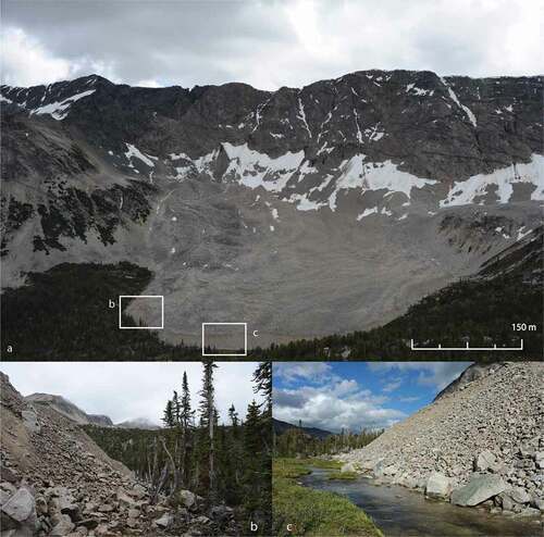
The gently sloping surface (15°) of Hellraving rock glacier is mantled by large angular boulders and covers approximately 0.5 km2 (1 km long by 0.5 km wide; ). The eastern extent of the rock glacier is distinguished by rounded, convoluted ridges beyond which a large depression is evident on the rock glacier surface. Downslope of the depression, a series of transverse ridges suggest that compressional flow has occurred within the lower section of the rock glacier (i.e., Kääb and Weber Citation2004). Vegetation and lichen were absent on the rock glacier surface.
Sediment sorting is evident on the rock glacier snout and flanks. Larger angular boulders form a 1–2 m thick layer on the surface of the rock glacier, while smaller cobbles and sands extend down the steeply sloping snout to the valley floor at 1,800 m a.s.l. ( and ). The toe area is surrounded by a mixed forest composed of whitebark pine (Pinus albicaulis) and subalpine fir (Abies lasiocarpa) trees (). A large pond interspersed with silt deposits and small rock fragments surrounds a portion of the rock glacier snout ().
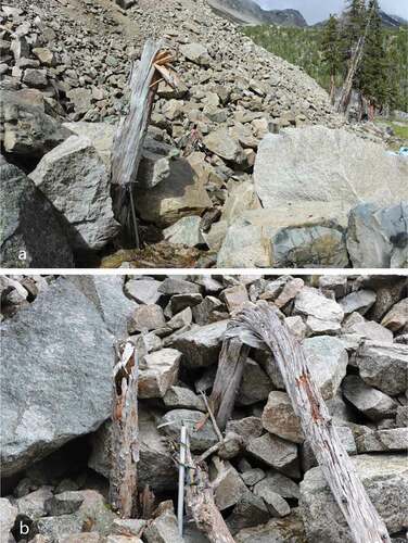
Boulders that have spilled beyond the rock glacier snout form a characteristic ring of boulders, or “boulder collar” (after Haeberli Citation1985). While dead and partially buried tree trunks emerge from this debris at several locations (), only the northernmost section of the snout appears to be active and advancing into standing trees. Within this area coarse rock debris is spilling down the steep frontal ramp (>30°) to overwhelm and progressively bury trees as the rock glacier advances downslope (). In contrast, most trees located in the eastern extent of the snout appear to have been killed by sporadic boulder topples spilling down moderately sloped talus (˂25°) to the valley floor (e.g., Barsch Citation1996).
Figure 4. Partially buried trunks and sheared stumps found in the frontal debris of Hellraving rock glacier: (a) sample HRG06 and (b) samples HRG14 (left) and HRG15 (right)
Dendrogeomorphological methods were employed to date the historical rate of advance of Hellraving rock glacier into the surrounding forest (e.g., Shroder Citation1978). Where trees appeared to have been killed by Hellraving rock glacier, their death date was obtained by cross-dating their annual growth rings to living tree-ring chronologies (Giardino, Shroder, and Lawson Citation1984). An annual rate of movement activity was then assigned by dividing the number of years since the time of death by the horizontal distance to the leading edge of continuous toe debris (Bachrach et al. Citation2004; Carter et al. Citation1999).
At Hellraving rock glacier partially buried rooted stumps and trunks were excavated, and cross-sections of the stems were cut with a chainsaw (). The horizontal distance from the root position to the debris edge was either directly measured or estimated where excavation was not possible. The tree samples were returned to the University of Victoria Tree-Ring Laboratory (UVTRL) where they were allowed to air dry, and tree species were identified using bark and anatomical characteristics (Hoadley Citation1990). Following this, the samples were sanded to a fine polish to highlight the annual ring boundaries. The samples were then scanned with a high-resolution scanner to obtain digital images, and the annual ring widths were measured along the longest pathway with a WinDendro (v. 2012c) image-processing measurement system (Guay, Gagnon, and Morin Citation1992).
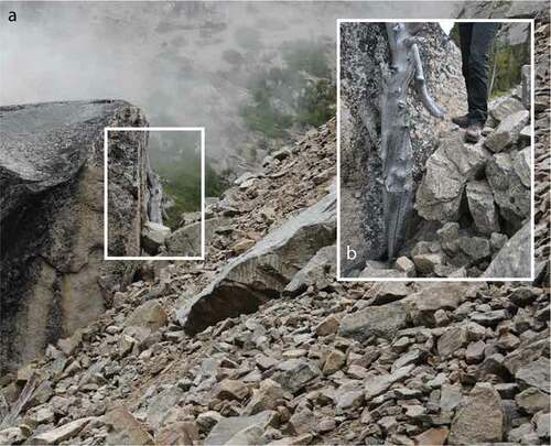
Figure 5. Hellraving rock glacier: (a) oldest sample (HRG16; AD 1674) shown pressed up against the proximal face of a large boulder and (b) close-up view of the sample, person for scale
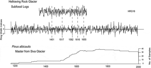
Minimum kill dates were assigned by cross-dating the samples to existent master tree-ring chronologies. Subalpine fir samples were cross-dated to a chronology collected by Starheim, Smith, and Prowse (Citation2013) at Jacobsen Glacier in the nearby Monarch Icefield area (AD 1533–2009). Whitebark pine samples were cross-dated to a tree-ring chronology from Siva Glacier (AD 1189–2000) constructed by Larocque and Smith (Citation2005a; ). The cross-dating was verified using COFECHA (Grissino-Mayer Citation2001; Holmes Citation1983), and the age of the outermost ring was assigned using the COFECHA master chronology.
Table 1. Characteristics of master tree-ring chronologies
Results
Inventory and distribution
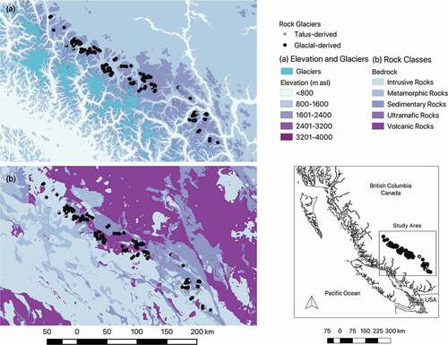
A total of 165 intact rock glaciers were identified in the study area (, ) with an indeterminate number likely overlooked because of topographic shading or poor image quality. Rock glaciers appeared evenly distributed within the intrusive, sedimentary, and volcanic rocks that characterize the southeastern front ranges of the Coast Mountains (, ). Rock glacier distribution was bounded by the Yalakom and Fraser faults to the east and plutons to the west. Rock glaciers have formed within the volcanic, marine, and sedimentary rocks of the Bridge River, Cadwallader, Methow, and Overlap terranes. Rock glaciers also formed within localized granitodioritic intrusives associated with the Post Accretionary terrane along the border between the southeast and southwest Coast Mountains.
Table 2. Rock glacier inventory for the Front Ranges study area, British Columbia
Table 3. Distribution of rock glaciers across bedrock classes attained from the digital Geological Map of British Columbia (Massey et al. Citation2005)
Figure 6. Map of the study area showing the location of the inventoried rock glaciers. The inset maps show the: (a) general terrain elevation of the study area and the location of prominent glaciers and icefields and (b) spatial position and extent of the major regional bedrock classes
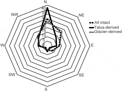
In the study area rock glaciers occupy predominately north-facing (NW, N, NE) slopes (). Glacier-derived rock glaciers display the broadest range of slope aspects, while talus-derived rock glaciers were primarily restricted to north-facing slopes (). The mean elevations for glacier-derived features and talus-derived features are similar (2,100 ±50 m and 2,090 ±50 m, respectively; ). Rock glaciers are generally located at sites with MAAT values of −1°C and MAP values of 1,250 mm/yr (). Despite some variation in the elevation or environmental conditions between categories (), the results of pairwise comparisons indicate that these differences are statistically insignificant (). No evidence was found to support a systematic difference in the altitudinal or environmental variables across the rock glacier categories.
Table 4. Summary of the environmental variables collected within the rock glacier inventory
Table 5. Results of the pairwise comparisons of environmental variables by rock glacier category
Figure 7. Relative abundance of slope aspects for all, glacier-derived, and talus-derived rock glaciers
The relationship between MAAT and elevation for glaciers and treeline was used to estimate the −3°C and 0°C isotherms, respectively (r = −0.87 for both; ). Because intact rock glaciers occur between the lower altitudinal boundary of glaciers and the upper extent of treeline (, ), their distribution was largely bounded by the estimated −3°C isotherm (2,400 m) and the 0°C isotherm (1,800 m).
Figure 8. The relationship between mean annual air temperature and elevation used to estimate the 0°C and −3°C isotherms
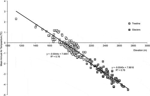
Figure 9. Regional elevation histograms for (a) intact rock glaciers, (b) glaciers, and (c) treeline. Each column represents 100 m in elevation
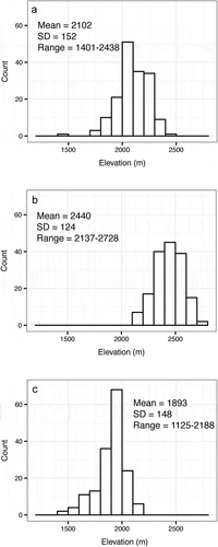
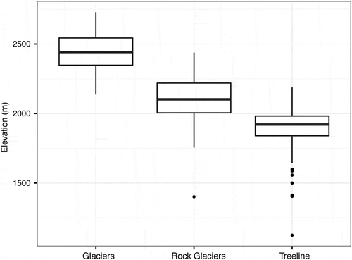
Figure 10. Boxplots indicate the elevation of inventoried intact rock glaciers as compared to glaciers and treeline. Outliers are shown as dots
Dendrogeomorphology at Hellraving rock glacier
The remains of erect and partially buried tree trunks found along the leading edge of Hellraving rock glacier were excavated in July 2014. The majority of trunks were traced to rooted stumps and boles found tipped over or broken in the direction of assumed rock glacier movement ( and ). A single whitebark pine bole (HRG16) was found pressed against the proximal face of a large lichen-covered boulder 5 m from the debris edge. Buried to an estimated depth of 3 m, this tree appears to have been overwhelmed as debris spilled from the rock glacier margin to surround the boulder.
Eleven cross sections were collected: ten subalpine fir trees were cross-dated to the Jacobsen Glacier chronology (), and one whitebark pine sample was cross-dated to the Siva Glacier chronology (). Younger samples were significantly correlated (r > 0.328) to their respective master chronology for the entire growth period. The oldest samples (HRG01, HRG14, HRG16) were significantly correlated to the master chronology during the past 100 years of growth (). Beyond this range, limited sample depth within the master chronologies prevented accurate cross-dating ( and ). Because impact wounds were not observed on the samples, we assume that the trees died shortly after burial was initiated.
Table 6. Kill dates and estimates of Hellraving rock glacier advance rate
Figure 11. Subalpine fir samples from Hellraving rock glacier visually cross-dated into the living subalpine fir master chronology from Jacobsen Glacier. Marker years, indicated by the dashed lines, were used to visually cross-date before verifying in COFECHA
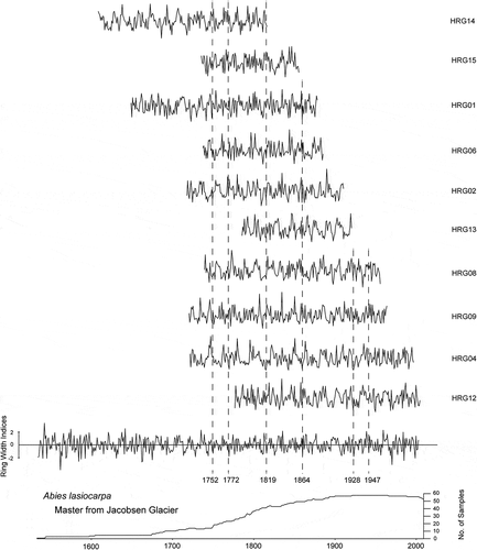
Figure 12. Whitebark pine sample from Hellraving rock glacier visually cross-dated to the living whitebark pine master chronology from Siva Glacier. Marker years, indicated by the dashed lines, were used to visually cross-date before verifying in COFECHA
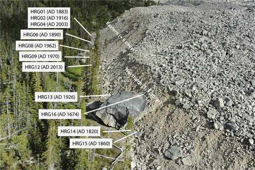
Dendrogeomorphological evidence describing the frontal advance of Hellraving rock glacier is limited to the northern snout area, where the trees were progressively buried by spilled debris. Large boulders with lichen-covered undersides characterize the steep talus apron in this location, suggesting that surface transport down the toe and deposition at the snout perimeter were responsible for the frontal advance (Barsch Citation1996; Koning and Smith Citation1999; Wahrhaftig and Cox Citation1959). Estimated rates of down-valley movement in this section range from 0.9 to 1.7 cm/yr (average 1.3 cm/yr) during the AD 1674–2003 period. In contrast, there is no evidence to suggest that the eastern toe area has moved down valley within the past 150 years (HRG01-12; .
Figure 13. Sample numbers and kill dates for trees sampled from the toe debris of Hellraving rock glacier. The northern and eastern sections of the terminus are also indicated along with the average advance rates
Discussion
Regional trends in the southwestern Canadian Cordillera
Rock glaciers are abundant in the southeastern front ranges of the Coast Mountains from 50°10ʹ to 52°08ʹ N latitude, with several forms present within a limited spatial area. Rock glaciers were observed originating from talus accumulated below steep headwalls, as well as in association with retreating glaciers. Rock glaciers were often seen extending from large hummocky moraines or directly from the debris-covered snouts of glaciers. Most rock glaciers have steep toe angles and appear to originate from fresh debris.
Contrary to findings in the southern Canadian Rocky Mountains, where rock glacier distribution is confined to the shales and quartzites of the Main Ranges, rock glacier distribution in the southeastern Coast Mountains appears to be consistent across several bedrock lithologies. While this finding is likely a product of the heterogeneous geology of the area and the coarse resolution of geologic maps (1:250,000; Massey et al. Citation2005), a close spatial association with the Yalakom fault system of the southern Chilcotin Ranges (Umhoefer and Schiarizza Citation1996) suggests that tectonic activity may influence headwall weathering rates and the production of talus. Where the large size of rock glaciers is not explained by local weathering rates and lithology, proximity to major faults known to trigger rock falls may account for high talus production (Bolch and Gorbunov Citation2014). Steep east-dipping faults, metamorphism, and volcanic arcs on the retro-wedge side of the bivergent Coast Mountain Range (Bustin et al. Citation2013; Mustard and van der Heyden Citation1997) warrant more investigation, yet are outside the scope of this research.
The distribution of intact rock glaciers at elevations above treeline ( and ) agrees with preliminary assessments of permafrost occurrence in the Coast Mountains. An average MAAT of −1°C for all rock glaciers () corroborates regional estimates of the lower limit of permafrost along MAAT isotherms of −1°C (Brown and Péwé Citation1973; French and Slaymaker Citation1993) and colder than 0°C (Harris Citation1981; Rodenhuis et al. Citation2007; ). The distribution also agrees with the general climatic boundaries of rock glacier development at high-elevation sites with below 0°C MAAT and moderate precipitation totals (<2,500 mm/yr; Brazier, Kirkbride, and Owens Citation1998; Haeberli Citation1985; Johnson, Thackray, and van Kirk Citation2007; Scotti et al. Citation2013).
Table 7. Previous estimates of permafrost in the front ranges of the Coast Mountains
In the study region, several of the rock glaciers included in the inventory were found at sites several kilometers up valley from the presumed terminal position of Younger Dryas valley glaciers (9390 ±40 BP; Grubb Citation2006). This maximum age, and that determined by Luckman and Crockett (Citation1978; 9000 ±500 BP) for rock glaciers in the southern Canadian Rocky Mountains, suggests that most rock glaciers in the Canadian Cordillera are likely of Holocene age. Despite reports of up to seven Holocene glacier advances in the region (Menounos et al. Citation2009; Mood and Smith 2015), pre-LIA moraines are largely absent in the study area and many rock glaciers were found distal to inferred LIA terminus positions. These permafrost landforms are large, well developed, and unlikely to have been produced by LIA climates alone. Complex rock glacier landforms with apparently older tongues, partially overwhelmed by unweathered rock debris, can be found throughout the study area. Their presence could explain the lack of relict rock glaciers included within the inventory. Many permafrost landforms in the front ranges are, therefore, assumed to predate the LIA and signify the presence of periglacial activity influenced by permafrost climates during the Holocene. Unlike the findings of some rock glacier inventories, a clear altitudinal boundary between intact and relict forms is not present in this area, and the complex relationship between Holocene climate variability and rock glacier activity warrants further investigation.
Glacier-derived rock glaciers display a broader distribution in aspect orientation. While the majority face to the north-northeast, between 10 percent and 15 percent of these rock glaciers occupy east- and west-facing slopes (). This finding suggests that topographic shading is not the dominant control of intact glacier-derived forms, as is evident with talus-derived rock glaciers, and that local conditions related to glacial dynamics are important for their distribution. Retreating glaciers lose energy through meltwater runoff, sometimes resulting in cold ablation areas with permafrost below the equilibrium line (Etzelmuller and Hagen Citation2005; Kneisel and Kaab Citation2007; Lilleøren et al. Citation2013b). This outcome, in combination with the high sediment supply of debris-covered glaciers (Kirkbride Citation2011), could explain a proglacial environment that is highly conducive to permafrost formation in the Front Ranges. The dominance of glacier-derived rock glaciers is consistent with other coastal-proximate studies, where frequent interaction between surface ice and permafrost conditions results in composite ice-debris features of both periglacial and glacial origin (Berthling Citation2011; Lilleøren et al. Citation2013a; Ribolini and Fabre Citation2006). In the European Alps and the Chilean Andes, active debris-ice features proximal to retreating glaciers indicate that a transition is occurring from glacial to periglacial processes under the contemporary climate (Monnier and Kinnard Citation2015; Seppi et al. Citation2015). Rock glaciers respond slower than glaciers to climatic variability because of the cooling and insulating effects of a thick debris cover (Janke et al. Citation2013; Kirkbride Citation2011). A large proportion of the glacier-derived features included within this inventory were observed originating from the debris-covered termini of retreating glaciers, suggesting that a similar transition is occurring in the Coast Mountains. Environmental conditions in the front ranges are, therefore, assumed to be presently conducive to periglacial activity yet are unable to support positive glacial mass-balance conditions. This finding further suggests that periglacial activity in this region may have persisted throughout interstadial periods of glacial retreat during the Holocene.
Movement at Hellraving rock glacier
The observed rates of frontal movement at Hellraving rock glacier are comparable to those described at sites in the Canadian Rocky Mountains, where similar investigations describe rates of frontal advance at two rock glaciers ranging from 1.2 to 1.6 cm/yr throughout the past several centuries (Bachrach et al. Citation2004; Carter et al. Citation1999). Comparable rates of contemporary frontal advance averaging 1.6 cm/yr were established by geodetic surveys at King’s Throne rock glacier in the Front Ranges of the Canadian Rocky Mountains (Koning and Smith Citation1999).
The rate of frontal advance established for Hellraving rock glacier is comparable to that recorded at other sites in North America and is similar to those reported for rock glaciers located in Central Asia, Greenland, and Svalbard (). Unlike the situation at many locations in the European Alps, where warming permafrost has accelerated rock glacier advance since the 1990s to several meters per year (Bodin et al. Citation2009; Delaloye et al. 2008, 2013; Ikeda, Matsuoka, and Kääb Citation2008; Roer et al. Citation2008), there was no indication of recent changes in the rate of frontal advance at Hellraving rock glacier. In this regard the behavior of Hellraving rock glacier is similar to that of rock glaciers in Colorado, where the rock glaciers are acclimatized to the present-day climate and do not display significant increases in activity during the past sixty years (Janke Citation2005).
Table 8. Published rates of rock glacier frontal advance. Based in part on Roer (Citation2005) and Burger, Degenhardt, and Giardino (Citation1999)
Conclusion
This study is the first to report on the presence of intact and active rock glaciers within the southeastern front ranges of the British Columbia Coast Mountains. All the rock glaciers surveyed are located at elevations between that of cirque glaciers in the region (average 2,400 ±50 m a.s.l.) and the local treeline (average 1,900 ±50 m a.s.l.). The research indicates that rock glacier distribution in the southeastern front ranges can be partly explained by topography and Holocene climates. Statistical rock glacier distribution models, with variables related to surface characteristics, snow accumulation, and topography (i.e., Brenning, Grasser, and Friend Citation2007; Brenning and Trombotto Citation2006; Esper Angillieri Citation2010; Johnson, Thackray, and van Kirk Citation2007), as well as ground temperature data, will be necessary to provide a detailed distribution of permafrost conditions (cf. Bonnaventure et al. Citation2012) in the Coast Mountains.
The estimated rate of frontal advance (1.3 cm/yr) for one rock glacier in the study area appears to have remained constant since AD 1674, even as rising regional air temperatures promoted glacial retreat and downwasting from LIA terminal positions (Bolch, Menounos, and Wheate Citation2010; Larocque and Smith Citation2003; Schiefer, Menounos, and Wheate Citation2007). These results are consistent with similar studies in the Canadian Rocky Mountains and support the observation of Janke (Citation2005) that climatic variability in North America has not caused the same marked change in rock glacier dynamics as witnessed in the European Alps (Delaloye et al. Citation2013; Roer et al. Citation2008). If air temperatures on the lee side of the British Columbia Coast Mountains continue to rise (Dawson, Werner, and Murdock Citation2008), however, the geomorphic activity of Hellraving rock glacier and other similarly positioned rock glaciers may soon fundamentally change.
The abundance of intact rock glaciers originating from the moraines and from the heavily debris-laden tongues of small alpine glaciers suggests that glacial and periglacial systems are highly interrelated in the Coast Mountains. Because air temperatures are predicted to continue rising in the study area (Dawson, Werner, and Murdock Citation2008), the influence of disappearing glaciers on permafrost landforms downslope should be monitored. Rock glaciers can store significant amounts of freshwater during times of drought, and an understanding of their internal characteristics and behavior is important to future water security in this region (Rangecroft et al. Citation2014). The inventory presented here is the first step toward monitoring rock glacier dynamics under changing climate regimes in the mountain landscapes of southwestern British Columbia.
Acknowledgments
Research funding was provided by a Natural Sciences and Engineering Research Council of Canada (NSERC) Discovery Grant to Smith. We thank Øyvind Paasche and an anonymous reviewer for their thoughtful insights and suggestions for improvement on an earlier version of the manuscript. Special thanks are offered to Bryan Mood and Vikki St-Hilaire for their assistance in the field.
Supplemental Material
Download Zip (13.8 KB)Disclosure statement
No potential conflict of interest was reported by the authors.
Related Research Data
References
- Associate Committee on Geotechnical Research. 1988. Glossary of Permafrost and Related Ground-Ice Terms. Technical Memorandum, Vol. 142. Ottawa, ON: National Research Council Canada.
- Bachrach, T., K. Jakobsen, J. Kinney, P. Nishimura, A. Reyes, C. P. Laroque, and D. J. Smith. 2004. Dendrogeomorphological assessment of movement at Hilda rock glacier, Banff National Park, Canadian Rocky Mountains. Geografiska Annaler 84A:1–24.
- Barsch, D. 1996. Rockglaciers: Indicators for the Present and Former Geoecology in High Mountain Environments. Heidelberg, Berlin: Springer-Verlag.
- Berger, J., K. Krainer, and W. Mostler. 2004. Dynamics of an active rock glacier (Ötztal Alps, Austria). Quaternary Research 62:233–42.
- Berthling, I. 2011. Beyond confusion: Rock glaciers as cryo-conditioned landforms. Geomorphology 131:98–106.
- Blumstengel, W. K., and S. A. Harris. 1988. Observations on an active lobate rock glacier, Slims River Valley, St. Elias Range, Canada. In Proceedings of the 5th International Conference on Permafrost, ed. K. Senneset., Vol. 1, 689–94. Trondheim: Norway, Tapir Publishers.
- Bodin, X., P. Schoeneich, and S. Jaillet. 2008. High-resolution DEM extraction from terrestrial LIDAR topometry and surface kinematics for the creeping alpine permafrost: The Laurichard rock glacier case study (Southern French Alps). Proceedings of the Ninth International Conference on Permafrost, D. L. Kane, and K. M. Hinkel, eds., Vol. 1, 137–42. Fairbanks: University of Alaska.
- Bodin, X., E. Thibert, D. Fabre, A. Ribolini, P. Schoeneich, B. Francou, L. Reynaud, and M. Fort. 2009. Two decades of responses (1986–2006) to climate by the Laurichard rock glacier, French Alps. Permafrost and Periglacial Processes 20:331–44. Fairbanks: University of Alaska.
- Boeckli, L., A. Brenning, S. Gruber, and J. Noetzli. 2012. Permafrost distribution in the European Alps: Calculation and evaluation of an index map and summary statistics. The Cryosphere 6:807–20.
- Bolch, T., and A. P. Gorbunov. 2014. Characteristics and Origin of Rock Glaciers in Northern Tien Shan (Kazakhstan/Kyrgyzstan). Permafrost and Periglacial Processes 25:320–32.
- Bolch, T., B. Menounos, and R. Wheate. 2010. Landsat-based inventory of glaciers in western Canada 1985 – 2005. Remote Sensing of the Environment 114:127–37.
- Bonnaventure, P. P., A. G. Lewkowicz, M. Kremer, and M. C. Sawada. 2012. A permafrost probability model for the southern Yukon and northern British Columbia, Canada. Permafrost and Periglacial Processes 23:52–68.
- Brazier, V., M. P. Kirkbride, and I. F. Owens. 1998. The relationship between climate and rock glacier distribution in the Ben Ohau Range, New Zealand. Geografiska Annaler 80A:193–207.
- Brenning, A. 2005. Geomorphological, hydrological and climatic significance of rock glaciers in the Andes of Central Chile (33-35S). Permafrost and Periglacial Processes 16:231–40.
- Brenning, A., M. Grasser, and D. A. Friend. 2007. Statistical estimation and generalized additive modeling of rock glacier distribution in the San Juan Mountains, Colorado, United States. Journal of Geophysical Research 112:1–10.
- Brenning, A., and D. Trombotto. 2006. Logistic regression modeling of rock glacier and glacier distribution: Topographic and climatic controls in the semi-arid Andes. Geomorphology 81:141–54.
- Brown, R. J. E., 1967: Permafrost in Canada. Map NRC 9769. National Research Council of Canada, Division of Building Research, Ottawa, and Geological Survey of Canada Map 1246A.
- Brown, R. J. E., and T. L. Péwé, 1973: Distribution of permafrost in North America and its relationship to the environment: A review, 1963-1973. In Permafrost: North American Contribution [to The] Second International Conference. Washington, DC:National Academy of Sciences.
- Burger, K. C., J. J. Degenhardt Jr, and J. R. Giardino. 1999. Engineering geomorphology of rock glaciers. Geomorphology 31:93–132.
- Bustin, A. M. M., R. M. Clowes, J. W. H. Monger, and J. M. Journeay. 2013. The southern Coast Mountains, British Columbia: New interpretations from geological, seismic reflection, and gravity data. Canadian Journal of Earth Sciences 50:1033–50.
- Carter, R., S. LeRoy, T. Nelson, C. P. Laroque, and D. J. Smith. 1999. Dendroglaciological investigations at Hilda Creek rock glacier, Banff National Park, Canadian Rocky Mountains. Géographie Physique Et Quaternaire 53:365–71.
- Chaix, A. 1943. Les coulées des blocs du Parc National Suisse: Nouvelles mesures et comparison avec les “rock streams” de la Sierra Nevade de Californie. Le Globe 82:121–28.
- Clark, D. H., M. M. Clark, and A. R. Gillespie. 1994a. Debris-covered glaciers in the Sierra Nevada, California, and their implications for snowline reconstruction. Quaternary Research 41:139–53.
- Clark, D. H., M. M. Clark, and A. R. Gillespie. 1994b. Reply to comment by M. Jakob on debris-covered glaciers in the Sierra Nevada, California, and their implications for snowline reconstruction. Quaternary Research 42:359–62.
- Clark, D. H., E. J. Steig, N. Potter, and A. R. Gillspie. 1998. Genetic variability of rock glaciers. Geografiska Annaler 80A:175–82.
- Dawson, R. J., A. T. Werner, and T. Q. Murdock. 2008. Preliminary analysis of climate change in the Cariboo-Chilcotin area of British Columbia. Victoria BC: Pacific Climate Impacts Consortium, University of Victoria. 49.
- Delaloye, R., S. Morard, C. Barboux, D. Abbet, V. Gruber, M. Riedo, and S. Gachet. 2013. Rapidly moving rock glaciers in Mattertal. In Mattertal–Ein Tal in Bewegung, C. Graf. ed., 21–31. Birmensdorf: Eidg. Forschungsanstalt WSL.
- Delaloye, R., E. Perruchoud, M. Avian, V. Kaufmann, H. Bodin, A. Ikeda, A. Kääb, A. Kellerer-Piklbauer, K. Krainer, C. Lambiel, et al., 2008: Recent interannual variations of rock glacier creep in the European Alps. In Ninth International Conference on Permafrost, Fairbanks, AK, 343–48.
- Esper Angillieri, M. Y. E. 2010. Application of frequency ratio and logistic regression to active rock glacier occurrence in the Andes of San Juan, Argentina. Geomorphology 114:396–405.
- Etzelmuller, B., and J. O. Hagen. 2005. Glacier-permafrost interaction in arctic and alpine mountain environments with examples from southern Norway and Svalbard. In Cryospheric Systems: Glaciers and Permafrost, eds. C. Harris, and J. B. Murton., Vol. 242, 11–27. London: Geological Society, Special Publications.
- Falconer, G., W. E. S. Henoch, and G. M. Østrem. 1965. A glacier map of southern British Columbia and Alberta. Geographical Bulletin 8:108–12.
- Francou, B., and L. Reynaud. 1992. Ten years of surficial velocities on a rock glacier (Laurichard, French Alps). Permafrost and Periglacial Processes 3:209–13.
- Frehner, M., A. H. M. Ling, and I. Gärtner-Roer, 2014: Furrow and ridge morphology on rockglaciers explained by gravity driven buckle folding: A case study from the Murtèl Rockglacier (Switzerland). Permafrost and Periglacial Processes. Published online in Wiley Online Library.
- French, H. M., and O. Slaymaker. 1993. Canada’s Cold Environments, Vol. 1. Montreal, QC: McGill Queen’s University Press.
- Gardner, J. 1978. Wenkchemna Glacier: Ablation complex and rock glacier in the Canadian Rocky Mountains. Canadian Journal of Earth Sciences 15:1200–04.
- Geogratis. 2013. Canadian Digital Elevation Model Product Specifications, Edition 1.1. Government of Canada, Natural Resources Canada, Map Information Branch, Sherbrooke, Quebec. http://ftp.geogratis.gc.ca/pub/nrcan_rncan/elevation/cdem_mnec/ doc/CDEM_product_specs.pdf.
- Giardino, J. R., J. F. Shroder, and M. P. Lawson. 1984. Tree-ring analysis of movement of a rock glacier complex on Mount Mestas, Colorado, U.S.A. Arctic, Antarctic, and Alpine Research 16:299–309.
- Gorbunov, A. P., 1983: Rock glaciers of the mountains of Middle Asia. In Proceedings of the Fourth International Conference on Permafrost. National Academy Press: Washington, 359–62.
- Gorbunov, A. P., S. N. Titkov, and V. G. Polyakov. 1992. Dynamics of rock glaciers of the northern Tien Shan and the Djungar Ala Tau, Kazakhstan. Permafrost and Periglacial Processes 3:29–39.
- Grissino-Mayer, H. D. 2001. Evaluating crossdating accuracy: A manual and tutorial for the computer program COFECHA. Tree-Ring Research 57:205–21.
- Grubb, M. C., 2006: Evidence for a late Pleistocene alpine glacier advance in the middle Coast Mountains, British Columbia. B.Sc. thesis, Geography Program, University of Northern British Columbia, Prince George, British Columbia.
- Guay, R., R. Gagnon, and H. Morin. 1992. A new automatic and interactive tree-ring measurement system based on a line scan camera. The Forestry Chronicle 38:138–41.
- Haeberli, W. 1985. Creep of mountain permafrost: Internal structure and flow of Alpine rock glaciers. Mitteilungen Der Versuchsanstalt Fur Wasserbau, Hydrologie Und Glaziologie an Der ETH Zurich 77:5–142.
- Haeberli, W., B. Hallet, L. Arenson, R. Elconin, O. Humlum, A. Kääb, V. Kaufmann, B. Ladanyi, N. Matsuoka, S. Springman, et al. 2006. Permafrost creep and rock glacier dynamics. Permafrost and Periglacial Processes 17:189–214.
- Harris, S. A. 1981. Climatic relationships of permafrost zones in areas of low winter snow-cover. Arctic 34:64–70.
- Harris, S. A., and R. J. E. Brown, 1981: Permafrost distribution along the Rocky Mountains in Alberta. Proceedings from the Fourth Canadian Permafrost Conference, pp. 59–67.
- Hasler, M., M. Geertsma, and M. Hoelzle, 2014: Permafrost favourability map of British Columbia. Conference Abstract, Geological Society of America Annual Meeting, Vancouver, British Columbia.
- Hausmann, H., K. Krainer, E. Brückl, and W. Mostler. 2007. Internal structure and ice content of Reichenkar rock glacier (Stubai Alps, Austria) assessed by geophysical investigations. Permafrost and Periglacial Processes 18:351–67.
- Heginbottom, J. A. 2002. Permafrost mapping: A review. Progress in Physical Geography 26:623–42.
- Heginbottom, J. A., M. A. Dubreuil, and P. A. Harker. 1995. Canada Permafrost, Sheet MCR 4177. The National Atlas of Canada, 5th. Ottawa: Natural Resources Canada.
- Hoadley, R. B. 1990. Identifying Wood: Accurate Results with Simple Tools. Newton, CT: The Taunton Press.
- Holmes, R. L. 1983. Computer-assisted quality control in tree-ring dating and measurement. Tree-Ring Bulletin 43:69–78.
- Humlum, O. 1982. Rock glacier types on Disko, central West Greenland. Geografisk Tidsskrift 82:59–66.
- Humlum, O. 1984. Altitudinal trends of talus-derived lobate rock glaciers on Disko, central West Greenland. Geografisk Tidsskrift 84:35–39.
- Humlum, O. 1996. Origin of rock glaciers: Observations from Mellemfjord, Disko Island, central West Greenland. Permafrost and Periglacial Processes 7:361–80.
- Humlum, O. 1997. Active layer thermal regime and three rock glaciers in Greeland. Permafrost and Periglacial Processes 8:383–408.
- Humlum, O. 1998. The climatic significance of rock glaciers. Permafrost and Periglacial Processes 9:375–95.
- Humlum, O. 2000. The geomorphic significance of rock glaciers: Estimates of rock glacier debris volumes and headwall recession rates in West Greenland. Geomorphology 35:41–67.
- Ikeda, A., N. Matsuoka, and A. Kääb. 2008. Fast deformation of perennially frozen debris in a warm rock glacier in the Swiss Alps: An effect of liquid water. Journal of Geophysical Research 113:1–12.
- Janke, J. R. 2005. Long-term flow measurements (1961-2002) of the Arapaho, Taylor, and Fair rock glaciers, Front Range, Colorado. Physical Geography 26:313–36.
- Janke, J. R., N. R. Regmi, J. R. Giardino, and J. D. Vitek. 2013. 8.17 Rock Glaciers. In Treatise on Geomorphology, Volume 8: Glacial and Periglacial Geomorphology, J. R. Giardino, and J. M. Harbor. eds., 238–73. San Diego: Elsevier Academic Press.
- Johnson, B. G., G. D. Thackray, and R. van Kirk. 2007. The effect of topography, latitude, and lithology on rock glacier distribution in the Lemhi Range, central Idaho, USA. Geomorphology 91:38–50.
- Johnson, P. G. 1978. Rock glacier types and their drainage systems, Grizzly Creek, Yukon Territory. Canadian Journal of Earth Sciences 15:1496–507.
- Johnson, P. 1980. Glacier-rock glacier transition in the Southwest Yukon Territory, Canada. Arctic and Alpine Research 12:195–204.
- Journeay, J. M., and R. M. Friedman. 1993. The Coast Belt thrust system: Evidence of Late Cretaceous shortening in southwest British Columbia. Tectonics 12:756–75.
- Kääb, A. 1996. Photogrammetrische Analyse zur Früherkennung gletscher- und permafrostbedingter Naturgefahren im Hochgebirge. Mitteilungen Der VAW/ETH Zürich 145:181.
- Kääb, A. 1997. Oberflächenkinematik ausgewählter Blockgletscher des Oberengadins. Beiträge aus der Gebirgs-Geomorphologie. Mitteilung Der VAW-ETH Zürich 158:121–40.
- Kääb, A., and C. Kneisel. 2006. Permafrost creep within a recently deglaciated glacier forefield: Muragl, Swiss Alps. Permafrost and Periglacial Processes 17:79–85.
- Kääb, A., and M. Weber. 2004. Development of transverse ridges on rock glaciers: Field measurements and laboratory experiments. Permafrost and Periglacial Processes 15:379–91.
- Kirkbride, M. 2011. Debris-covered glaciers. In Encyclopedia of Snow, Ice, and Glaciers, V. P. Singh, P. Singh, and U. K. Haritashya. eds., 190–92. Netherlands: Springer.
- Kneisel, C., and A. Kääb. 2007. Mountain permafrost dynamics within a recently exposed glacier forefield inferred by a combined geomorphological, geophysical and photogrammetrical approach. Earth Surface Processes and Landforms 32:1797–810.
- Koning, D. M., and D. J. Smith. 1999. Movement of Kings Throne rock glacier, Mount Rae area, Canadian Rocky Mountains. Permafrost and Periglacial Processes 10:151–62.
- Krainer, K., and W. Mostler. 2000. Reichenkar rock glacier: A glacier derived debris-ice system in the western Stubai Alps, Austria. Permafrost and Periglacial Processes 11:267–75.
- Krummenacher, B., K. Budmiger, D. Mihajlovic, and B. Blank. 1998. Periglaziale Prozesse und Formen im Furggentälti, Gemmipass. In Analysen zur räumlich-zeitlichen Entwicklung der Permafrostverbreitung und der Solifluktion, basierend auf der Entwicklung und Anwendung moderner Arbeitsmethoden, 245. Davos Dorf: Mitteilungen des Eidgenössisches Institutes für Schnee-und Lawinenforschung.
- Larocque, S. J., and D. J. Smith. 2003. Little Ice Age glacial activity in the Mt. Waddington area, British Columbia Coast Mountains, Canada. Canadian Journal of Earth Sciences 40:1413–36.
- Larocque, S. J., and D. J. Smith. 2005a. A dendroclimatological reconstruction of climate since AD 1700 in the Mt. Waddington area, British Columbia Coast Mountains, Canada. Dendrochronologia 22:93–106.
- Larocque, S. J., and D. J. Smith. 2005b. ‘Little Ice Age’ proxy glacier mass balance records reconstructed from tree rings in the Mt Waddington area, British Columbia Coast Mountains, Canada. The Holocene 15:748–57.
- Lilleøren, K. S., and B. Etzelmuller. 2011. A regional inventory of rock glaciers and ice-cored moraines in Norway. Geografiska Annaler 93A:175–91.
- Lilleøren, K. S., B. Etzelmüller, I. Gärtner‐Roer, A. Kääb, S. Westermann, and Á. Guðmundsson. 2013a. The distribution, thermal characteristics and dynamics of permafrost in Tröllaskagi, Northern Iceland, as inferred from the distribution of rock glaciers and ice-cored moraines. Permafrost and Periglacial Processes 24:322–35.
- Lilleøren, K. S., O. Humlum, A. Nesje, and B. Etzelmüller. 2013b. Holocene development and geomorphic processes at Omnsbreen, southern Norway: Evidence for glacier–Permafrost interactions. The Holocene 23:796–809.
- Luckman, B. H., and K. J. Crockett. 1978. Distribution and characteristics of rock glaciers in the southern part of Jasper National Park, Alberta. Canadian Journal of Earth Sciences 15: 540–50.
- Margold, M., K. N. Jansson, J. Kleman, A. P. Stroeven, and J. J. Clague. 2013. Retreat pattern of the Cordilleran Ice Sheet in central British Columbia at the end of the last glaciation reconstructed from glacial meltwater landforms. Boreas 42:830–47.
- Martin, H. E., and W. B. Whalley. 1987. Rock glaciers part 1: Rock glacier morphology: Classification and distribution. Progress in Physical Geography 11:260–82.
- Massey, N. W. D., J. W. MacIntyre, P. J. Desjardins, and R. T. Cooney, 2005: Ministry of Energy and Mines, Geofiles. Available at: http://www.empr.gov.bc.ca/Mining/Geoscience/BedrockMapping/Pages/BCGeoMap.aspx
- Menounos, B., G. Osborn, J. J. Clague, and B. H. Luckman. 2009. Latest Pleistocene and Holocene glacier fluctuations in western Canada. Quaternary Science Reviews 28:2049–74.
- Monger, J. W. H., and J. M. Journeay. 1994. Guide to the geology and tectonic evolution of the southern Coast Mountains. In Geological Survey of Canada Open File 2490, 77. Ottawa, Ontario: Geological Survey of Canada.
- Monnier, S., C. Camerlynck, F. Rejiba, C. Kinnard, and P. Y. Galibert. 2013. Evidencing a large body of ice in a rock glacier, Vanoise Massif, Northern French Alps. Geografiska Annaler 95A:109–23.
- Monnier, S., and C. Kinnard. 2015. Reconsidering the glacier to rock glacier transformation problem: New insights from the central Andes of Chile. Geomorphology 238:47–55.
- Mood, B. J., and D. J. Smith. 2015. Holocene glacier activity in the British Columbia Coast Mountains, Canada. Quaternary Science Reviews 128:14–36.
- Mustard, P. S., and P. van der Heyden. 1997. Geology of Tatla Lake (92N/15) and the east half of Bussel Creek (92N/14) map areas. Geological Survey of Canada, Paper 2:103–18.
- Ødegard, R. S., K. Isaksen, T. Eiken, and J. L. Sollid. 2003. Terrain analyses and surface velocity measurements of the Hiorthfjellet rock glacier, Svalbard. Permafrost and Periglacial Processes 14:359–65.
- Osborn, G. 1975. Advancing rock glacier in the Lake Louise area, Banff National Park. Canadian Journal of Earth Sciences 12:1060–62.
- Østrem, G. 1966. The height of the glaciation limit in southern British Columbia and Alberta. Geografiska Annaler 48A:126–38.
- Østrem, G., and K. Arnold. 1970. Ice-cored moraines in southern British Columbia and Alberta, Canada. Geografiska Annaler 52A:120–28.
- Pillewizer, W. 1957. Untersuchungen an Blockströmen der Ötztaler Alpen. Abhandlungen Des Geographischen Institutes Der Freie UniversitäT Berlin 5:37–50.
- Potter, N., Jr. 1972. Ice-cored rock glacier, Galena Creek, Northern Aksaroka Mountains, Wyoming. Geological Society of America Bulletin 83:3025–58.
- Racoviteanu, A. E., F. Paul, B. Raup, S. J. S. Khalsa, and R. Armstrong. 2009. Challenges and recommendations in mapping of glacier parameters from space: Results of the 2008 Global Land Ice Measurements from Space (GLIMS) workshop, Boulder, Colorado, USA. Annals of Glaciology 50(53):53–69.
- Rangecroft, S., S. Harrison, K. Anderson, J. Magrath, A. P. Castel, and P. Pacheco. 2014. A First rock glacier inventory for the Bolivian Andes. Permafrost and Periglacial Processes 25:333–43.
- Ribolini, A., and D. Fabre. 2006. Permafrost existence in the rock glaciers of the Argentera Massif (Maritime Alps, Italy). Permafrost and Periglacial Processes 17:49–63.
- Roddick, J. A. 1983. Geophysical review and composition of the Coast Plutonic Complex, south of latitude 55°N. Circum-Pacific Plutonic Terranes: Geological Society of America Memoir 159:195–211.
- Rodenhuis, D. R., K. E. Bennett, A. T. Werner, T. Q. Murdock, and D. Bronaugh. 2007. Hydro-climatology and future climate impacts in British Columbia. In Pacific Climate Impacts Consortium, 1–132. Victoria: University of Victoria.
- Roer, I. 2005. Rockglacier kinematics in a high mountain geosystem. PhD diss., Universitäts-und Landesbibliothek Bonn.
- Roer, I., W. Haeberli, M. Avian, V. Kaufmann, R. Delaloye, C. Lambiel, and A. Kääb. 2008. Observations and considerations on destabilizing active rock glaciers in the European Alps. Ninth International Conference on Permafrost, 1505–10.
- Rusli, N., M. R. Majid, and A. H. M. Din. 2014. Google Earth’s derived digital elevation model: A comparative assessment with Aster and SRTM data. IOP Conference Series: Earth and Environmental Science 18:1–6.
- Schiefer, E., B. Menounos, and R. Wheate. 2007. An inventory and morphometric analysis of British Columbia glaciers, Canada. Journal of Glaciology 54:551–60.
- Schmid, M.-O., P. Baral, S. Gruber, S. Shahi, T. Shrestha, D. Stumm, and P. Wester. 2014. Assessment of permafrost distribution maps in the Hindu Kush-Himilayan region using rock glaciers mapped in Google Earth. The Cryosphere Discussions 8:5293–319.
- Schneider, B., and H. Schneider. 2001. Zur 60jährigen Messreihe der kurzfristigen Geschwindigkeitsschwankungen am Blockgletscher im Äusseren Hochebenkar, Ötztaler Alpen, Tirol. Zeitschrift FüR Gletscherkunde Und Glazialgeologie 37:1–33.
- Scotti, R., F. Brardinoni, S. Alberti, P. Frattini, and G. B. Crosta. 2013. A regional inventory of rock glaciers and protalus ramparts in the central Italian Alps. Geomorphology 186:136–49.
- Seppi, R., T. Zanoner, A. Carton, A. Bondesan, R. Francese, L. Cartura, M. Zumiani, M. Giorgi, and A. Ninfo. 2015. Current transition from glacial to periglacial processes in the Dolomites (South-Eastern Alps). Geomorphology 228:71–86.
- Sherzer, W. H. 1907. Glaciers of the Canadian Rockies and Selkirks (Smithsonian Expedition of 1904). Smithsonian Institution, No. 1692. Washington, DC.
- Shroder, J. F. 1978. Dendrogeomorphological analysis of mass movement on Table Cliffs Plateau, Utah. Quaternary Research 9:168–85.
- Sloan, V. F., and L. D. Dyke. 1998. Decadal and millennial velocities of rock glaciers, Selwyn Mountains, Canada. Geografiska Annaler 80A:237–49.
- Sorg, A., A. Kääb, A. Roesch, C. Bigler, and M. Stoffel. 2015. Contrasting responses of Central Asian rock glaciers to global warming. Nature Research Journal: Scientific Reports 5:8228.
- Spittlehouse, D., and T. Wang. 2014. Evaluation of ClimateBC V5. Retrieved from http://climatemodels.forestry.ubc.ca/climatebc/downloads/ClimateBCv5_evaluation.pdf
- Starheim, C. C. A., D. J. Smith, and T. D. Prowse. 2013. Multi-century reconstructions of Pacific salmon abundance from climate-sensitive tree rings in west central British Columbia, Canada. Ecohydrology 6:228–40.
- Steinman, B. A., M. B. Abbott, M. E. Mann, J. D. Ortiz, S. Feng, D. P. Pompeani, N. D. Stansell, L. Anderson, B. P. Finney, and B. W. Bird. 2014. Ocean-atmosphere forcing of centennial hydroclimate variability in the Pacific Northwest. Geophysical Research Letters 41:2553–60.
- Umhoefer, P. J., and P. Schiarizza. 1996. Latest Cretaceous to early Tertiary dextral strike-slip faulting on the southeastern Yalakom fault system, southeastern Coast Belt, British Columbia. Geological Society of America Bulletin 108:768–85.
- van der Heyden, P., P. S. Mustard, and R. Friedman. 1994. Northern continuation of the Eastern Waddington Thrust Belt and Tyaughton Trough, Tatla Lake-Bussel Creek map areas, west-central British Columbia. In Current Research 1994-A, Cordillera and Pacific Margin, 87–94. Ottawa, Ontario: Geological Survey of Canada.
- VanLooy, J. A., and R. R. Forster. 2008. Glacial changes of five southwest British Columbia icefields, Canada, mid-1980s to 1999. Journal of Glaciology 54(186):469–78.
- Wahrhaftig, C., and A. Cox. 1959. Rock glaciers in the Alaska Range. Geological Society of America Bulletin 70:383–436.
- Wang, T., A. Hamann, D. L. Spittlehouse, and S. N. Aitken. 2006. Development of scale-free climate data for Western Canada for use in resource management. International Journal of Climatology 26:383–97.
- Wang, T., A. Hamann, D. L. Spittlehouse, and T. Q. Murdock. 2012. ClimateWNA-High-resolution spatial climate data for western North America. Journal of Applied Meteorology and Climatology 51:16–29.
- White, S. E. 1971. Rock glacier studies in the Colorado Front Range, 1961 to 1968. Arctic and Alpine Research 3(1):43–64.
- White, S. E. 1987. Differential movement across transverse ridges on Arapaho rock glacier, Colorado, Front Range, USA. In Rock Glaciers, J. R. Giardino, J. F. Shroder Jr, and J. D. Vitek. eds., 145–49. London: Allen and Unwin.
- Wood, L. J., D. J. Smith, and M. N. Demuth. 2011. Extending the Place Glacier mass-balance record to AD 1585, using tree rings and wood density. Quaternary Research 76:305–13.