
 ?Mathematical formulae have been encoded as MathML and are displayed in this HTML version using MathJax in order to improve their display. Uncheck the box to turn MathJax off. This feature requires Javascript. Click on a formula to zoom.
ABSTRACT
We present the first comprehensive inventory and analysis of rock glaciers in the hydrographic Great Basin (GB), United States, documenting 842 features (mean 9.9 ha; range 0.1–201 ha) across thirty-two mountain ranges. These encompassed 8° latitude (from 36.5°N to 44.3°N) and 11° longitude (from −110.7°W to −121.4°W), and composed 83.1 km2, or 1.1 percent, of the cumulative area above the lowest rock glacier elevation. Forty-five percent of the features were mapped as intact (containing ice) and occurred across sixteen mountain ranges. Rock glaciers conservatively contained cumulative water volume of 0.8924 km3. We also mapped 237 persistent ice fields from thirteen GB ranges. Ice-field water equivalent was 0.0653 km3; rock glaciers contributed 93 percent of the total water volume (rock glacier:icefield ratio, 14:1). Rock glaciers occurred on northerly aspects at high elevations (mean, 3,196 m) and had a mean annual air temperature of 1.7°C (range, 1.3–3.3°C). Contributions of water from rock-glacier springs and groundwater have not been included in GB hydrologic assessments, nor have rock glaciers been evaluated for their roles in supporting cold-adapted aquatic fauna and promoting vegetation communities and habitat for alpine terrestrial species. Rock glaciers provide hydrologic and ecologic refugia previously unrecognized in the GB with respect to warming future climates.
Introduction
Rock glaciers are high-elevation, rocky landforms, common in many mountain regions of the world. They have been subject to extensive study on topics relating to morphology (Barsch Citation1977, Citation1992; Martin and Whalley Citation1987), internal structure (Burger, Degenhardt, and Giardino Citation1999; Hausmann et al. Citation2007, Citation2012), origin and development (Clark et al. Citation1998; Anderson et al. Citation2018), movement (Haeberli et al. Citation2006; Kääb, Frauenfelder, and Roer Citation2007; Liu et al. Citation2013), paleohistoric and recent climate (Clark et al. Citation1996; Millar and Westfall Citation2008), and roles in permafrost processes (Barsch Citation1996; Osterkamp and Romanovsky Citation1999). Hitherto little discussed outside the cryosphere community, rock glaciers are attracting increasing attention for their role as persistent mountain reservoirs, significant in a warming world (Azócar and Brenning Citation2010; Rangecroft, Harrison, and Anderson Citation2015; Jones et al. Citation2018, Citation2019). Ice that accumulates in deep, rocky mantles or glacial ice that is buried by rock debris, is insulated against changes in external air temperature and lags in response to seasonal and long-term climatic variability (Burger, Degenhardt, and Giardino Citation1999; Brenning Citation2005; Liu et al. Citation2013). The recent comprehensive study by Jones et al. (Citation2018) to quantify the water content of rock glaciers and compare that to ice glaciers provides an important estimate of relative significance at the global scale. Despite important advances in understanding the hydrologic processes of rock glaciers (Burger, Degenhardt, and Giardino Citation1999; Brenning Citation2005; Hausmann et al. Citation2012) and in quantifying mountain aquifers (Krainer and Mostler Citation2002; Azócar and Brenning Citation2010; Rangecroft, Harrison, and Anderson Citation2015; Jones et al. Citation2018), knowledge of the output and significance of rock glaciers remains scant for most regions (Colombo et al. Citation2018).
At the regional scale in North America, there have been no systematic efforts to assess distribution or climatic attributes of rock glaciers, although some individual ranges and parts of ranges have been mapped and evaluated (Wahrhaftig and Cox Citation1959; Ellis and Calkin Citation1979; Janke Citation2007; Johnson, Thackray, and Van Kirk Citation2007; Millar and Westfall Citation2008). An inventory of rock glaciers for western North America was developed for Fegel et al. (Citation2016), but is unpublished. Fegel et al. (Citation2016) evaluated comparative biochemistry and microbial characteristics of glacial and rock glacial springs from sample locations in the Cascade Mountains, Rocky Mountains, and Sierra Nevada. No attempts have been made to quantify the water content of rock glaciers in North American mountains or to evaluate their hydrologic contribution relative to water stored in glaciers or ice patches (collectively, persistent ice fields). The present study addressed gaps in the understanding of North American rock glaciers for a large, semiarid mountainous region, the Great Basin (GB), by addressing the following questions:
What is the extent and distribution of rock glaciers and persistent ice fields in the hydrographic GB?
What climate variables correlate with rock glacier locations? How do these vary across the GB and compare to climates in other rock glacier regions of the world?
What is the quantitative estimate of the water content of rock glaciers relative to persistent ice fields for individual mountain ranges, GB subregions, and collectively across the GB? How does this compare to other mountain regions, and what are the implications for GB hydrology and ecosystems of these little-recognized land forms?
Setting: The Great Basin
The hydrographic GB encompasses a large area of the southwestern United States, covering 520,000 km2 and is defined by topography where surface waters drain into interior, evaporative basins. Extending from 33° to 44° north latitude and 111° to 122° west longitude, the GB includes parts of California, Oregon, Idaho, Utah, and most of Nevada (). Contained within this region are approximately 635 mountain ranges (Charlet Citation1996; Grayson and Basin Citation2011). Many ranges attain alpine elevations, with the highest summits extending higher than 4,000 m (highest, Mt Whitney, CA, 4,421 m); sixty-eight ranges in Nevada alone reach above 2,750 m (Charlet Citation1996). The area is geologically complex, with orogenies resulting from Cenozoic continental plate dynamics and extensional faulting (Grayson and Basin Citation2011). Major cordillera of the GB include the Sierra Nevada of California, whose hydrographic crest defines the western boundary of the GB, and the Wasatch Mountains east of Great Salt Lake, Utah, near the eastern GB boundary. Bedrock in the higher elevations of GB mountains includes Paleozoic quartzites and carbonates, Mesozoic meta-sedimentary and meta-volcanic rocks, Cenozoic granitic and gneissic intrusions, and Tertiary volcanic rocks. While the region as a whole is semiarid, climates vary across latitude and longitude, and include warm Mediterranean systems dominated by wet winters and long dry summers, hot desert climates of the southern GB, cold continental climates, and regions with monsoon effects that result in the sparse annual rainfall distributed across seasons.
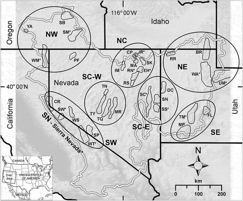
Figure 1. Map of the hydrographic Great Basin study region, United States, showing mountain ranges containing rock glaciers, ranges with persistent ice fields (marked with *), and eight subregions used in analysis. Mountain ranges are defined in . Subregions: SN = Sierra Nevada (not enclosed by polygon); SW = southwest; NW = northwest; SC-W = south-central west; SC-E = south-central east; NC = north central; NE = northeast; SE = southeast.
Many of the higher mountain ranges of the GB bear clear evidence of past glaciation, several of which have been the focus of intensive study. Pleistocene glaciers carved textbook cirques and canyons, and left deposits of obvious glacial origin in at least forty-one ranges (Osborn and Bevis Citation2001). Glacial inventories and chronologies are best developed for the Sierra Nevada (Blackwelder Citation1931; Sharp and Birman Citation1963; Phillips et al. Citation1996; Clark and Gillespie Citation1997), Snake Range (Piegat Citation1980; Wayne Citation1984), Ruby Mountains/East Humboldt Range (Sharp Citation1938; Wayne Citation1984), Wasatch Mountains (Blackwelder Citation1931; Madsen and Currey Citation1979), and Uinta Mountains (GB portion; Oviatt Citation1994). Osborn and Bevis (Citation2001) summarized these and provided a GB-wide review. Pleistocene glaciers in the GB are recognized as having melted by the early Holocene (Madsen and Currey Citation1979; Clark and Gillespie Citation1997). Small glaciers redeveloped in the highest cirques of two to three ranges during the late Holocene, some of which remain (Bowerman and Clark Citation2011; Glaciers of the American West, accessed December 21, 2018, http://glaciers.us/index).
The Sierra Nevada, California (including the parts outside the GB), has the largest number of contemporary glaciers, although they are declining. An inventory based on 1975–1984 photos mapped 1,719 glaciers and small ice fields (including 122 “true” glaciers), 90 percent of which were less than 0.05 km2 in area (Basagic and Fountain Citation2011). The largest remaining glacier in the Sierra Nevada, the Palisades Glacier west of Big Pine, California, covers 0.8352 km2 (Basagic and Fountain Citation2011). Fifty-two percent of the glacial area in the Sierra Nevada disappeared between 1990 and 2013 (McCabe and Fountain Citation2013). The largest glaciers in Yosemite National Park, Lyell and Maclure Glaciers, have been intensively monitored for nearly 150 years. Detailed study shows that they have diminished by 68–79 percent since 1883, with as much as 16 percent of that loss during the California drought of 2012–2015 (Stock et al. Citation2017).
Outside the Sierra Nevada, only one other glacier is recognized in the GB, the Wheeler Glacier in the Snake Range, Nevada (Osborn and Bevis Citation2001; Glaciers of the American West, accessed December 21, 2018, http://glaciers.us/index); however, its status is tentative given recent warming. Graham (Citation2014) describes the exposed ice as having melted entirely, whereas in the dry year of 2014 a small persistent ice patch remained visible at the base of the headwall (pers. obs. CIM; September 2014). A glacierette was described in the early twentieth century at Mt. Timpanogos in the Wasatch Mountains, Utah (Ives Citation1950), but it appears to have melted by the mid-twentieth century, and is not recognized in recent inventories (Glaciers of the American West, accessed December 21, 2018).
No systematic inventory has been done of rock glaciers or rock-glacier till for any mountain range in the GB, let alone the entire region. The Sierra Nevada has received the most study, where research has been limited either to specific regions, such as the central-eastern Sierra Nevada (Kesseli Citation1941; Millar and Westfall Citation2008), or focused on a small number of features for intensive study; for example, to reconstruct the former snow line (Clark, Clark, and Gillespie Citation1994) or to assess contemporary movement (Liu et al. Citation2013). Coats (Citation1964) briefly noted several rock glaciers in the Jarbidge Range during preparation of a geologic map. The prominent rock glacier on Wheeler Peak in the Snake Range has long been described and studied (Russell Citation1885; Graham Citation2014). In an unpublished Master’s thesis, Piegat (Citation1980) mapped glacial geology in central Nevada, noting a few rock glaciers in the Toiyabe, Toquima, and Snake Ranges. These were corroborated and supplemented by the observations of Osborn and Bevis (Citation2001), whose primary focus was on (ice) glacial geology. By and large, rock glaciers have gone unnoticed and unstudied across the Great Basin.
Methods
Mapping
Rock glaciers
The perimeter boundary of the hydrographic GB was derived from the National Hydrography Dataset (Levels 2, 3, and 4 HUC; USGS, The National Map: https://viewer. nationalmap.gov/basic/#startUp, accessed October 11, 2017). We restricted mapping to rock glaciers and persistent ice features within this boundary, with exceptions: features on the east slope of the main crest of the Jarbidge Range, Nevada, the east slope of the Fish Lake Mountains, Utah, and the north slope of the Raft River Range, Utah, were included. These slopes contain features in regions that are otherwise sparsely represented, lie less than 1 km from the GB boundary, and occur in the same geoclimatic environment as adjacent slopes within the GB. All GB mountain ranges previously noted to contain glacial topography (Osborn and Bevis Citation2001) were assessed, as were a number of additional high ranges. Ranges where no features were found are listed in Supplemental Table S1.
Mapping was done in Google Earth Pro (GEP; versions 7.3.1 and 7.3.2). With 3-D navigating, GEP imagery reveals features better than do other imagery or maps. The most current imagery in GEP was used unless historical imagery better revealed features because of lack of snow or sun angle, and so forth. Included as “rock glaciers” were landforms having a tongue-shape or lobate form, over-steepened sides and/or fronts, and often having furrowed surfaces (classic rock glaciers, sensu Wahrhaftig and Cox Citation1959; Barsch Citation1996). Also included as rock glaciers were landforms referred to as sidewall rock glaciers or protalus ramparts (Martin and Whalley Citation1987), because these features can contain persistent ice (Johnson Citation1983; Anderson et al. Citation2018). These are mostly wider than long, have over-steepened fronts, and are located in cirques, valley heads, or under crests and valley walls.
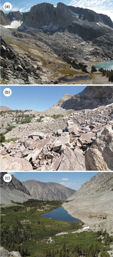
For each rock glacier feature, the following attributes were derived from GEP: latitude and longitude of midpoint, elevation at the top and bottom, area, aspect using cardinal and ordinal octants, presence or absence of furrows, environment of the forefield (water body, springs, wet meadow, shrub wetland, aspen-riparian, upland vegetation, or rock), and association or not with a persistent ice field. We assigned a morphology type to each feature as follows (): RGC was a classic rock-glacier landform in a cirque setting; TALV was a rampart below talus and along a valley or ridge wall; and TALC was a rampart or nascent lobate/tongue-shaped feature below talus in a cirque or below talus along main crests or in a headwall setting. Features with over-steepened fronts but of uncertain origin were classed as SLUMPs. Solifluction lobes, patterned ground, and other periglacial forms were not included. Large rock-glacier tills at low elevation and of likely Pleistocene origin were excluded. For each feature we estimated the angle of the steepened front, using measurements from GEP and standard trigonometry. Examples of mapping methods are in Supplemental Figure S1.
Figure 2. Examples of rock-glacier morphology types mapped in the Great Basin. (a) Cirque rock glacier (RGC); (b) crest-headwall rock glacier (TALC); (c) valley wall rock glacier (TALV; protalus rampart).
Rock-glacier activity, that is, presence or absence of internal ice and movement, has been subject to lengthy discussion in the literature, and is related to similarly lengthy debates about the glacigenic versus periglacial origins (e.g., Wahrhaftig and Cox Citation1959; Clark et al. Citation1998; Burger, Degenhardt, and Giardino Citation1999; Anderson et al. Citation2018; Knight, Harrison, and Jones Citation2019). Recognizing that while some features with high probability contain ice (active) and some do not (relict), without knowledge of internal structure the activity level cannot be definitively assessed from external morphology alone. Given the current conditions of headwall ice (thin veneer) separated from rock-glacier bodies, the lack of active LIA (Little Ice Age) glaciation in much of the GB outside the Sierra Nevada, and the absence of moraine evidence for extensive glaciers in the Sierran LIA, we assume that GB rock glaciers are unlikely to be debris-covered glaciers. Instead, we assume ice in active GB features to be either fully contained in ice-rich permafrost, as in Hausmann et al. (Citation2012; their Figure 10a) or “hybrid” forms whereby glacial ice or a persistent ice field occupies only a small fraction of the rock glacier in the uppermost cirque. Aside from these assumptions about debris-covered glaciers, we took a neutral position regarding the origin when classifying features, with the assumption of equifinality of causes (Johnson Citation1983; Burger, Degenhardt, and Giardino Citation1999; Anderson et al. Citation2018). We addressed activity by ascribing condition classes with the following strategy: We first mapped features in the Sierra Nevada where ice-embedded, moving rock glaciers have been identified (Liu et al. Citation2013); these are most securely “active.” Using those features as standards, we assessed traits most likely related to their activity (Barsch Citation1996; Burger, Degenhardt, and Giardino Citation1999), finding no single or consistent threshold or status that regularly distinguished active features. There were, however, combinations of attributes—not all always present—that characterized active features, including steep front and side angles; unweathered boulders; large boulders pitched at the crest of the fronts and sides; fine sediment on the fronts below the crest; steep-crested furrows on the surface; high elevation and cold aspect; sparse or no vegetation on the feature; springs, tarns, and/or wetland below the front—if tarns, water may contain suspended sediments and appear aquamarine in color; and associated persistent ice fields above the feature or thermokarsts revealing ice on the surface. By contrast, the morphology of other features suggested that they neither contained ice nor were moving. These included gradually sloping fronts with vegetation and/or boulder cover, weathered boulders, lower elevation and warm aspects, upland vegetation (trees, dry shrub) on the forefields, and no persistent ice fields above the feature. Many features had combinations of these characteristics.
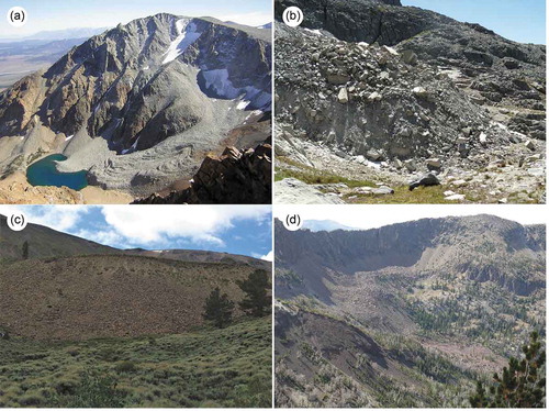
Based on this GEP exercise and extensive field observations, we followed the approach used by Barsch (Citation1992) and many others to ascribe condition classes as “active” (A1) for those features that had most or all of the characters of known active features (), “relict” (R) for those with least or no characters of active features (), and “inactive” (A2) for those intermediate (), but more similar to active than relict. In so doing, we considered these labels to be hypotheses about the condition of each feature pending study of their internal morphologies or other confirmation. Field observations of a subset of characters after GEP mapping, including those we have observed prior to the current mapping effort and/or mapped in our prior study (Millar and Westfall Citation2008), added confidence to the characterizations.
Figure 3. Examples of condition types estimated for features mapped in the Great Basin. (a) Active (A1), Mt. Gibbs, Sierra Nevada, California; (b) active front (A1), Mammoth Crest, Sierra Nevada, California; (c) likely active (A2), Moores Canyon, Toquima Range, Nevada; (d) relict (R), Cougar Peak, Jarbidge Range, Nevada.
Persistent ice fields
Although our study focused on rock glaciers, a goal was to compare the water content of rock glaciers to persistent ice fields. To do so, we mapped ice fields using GEP. To distinguish persistent ice from annual snow, we alternated among historical imagery views on GEP to focus on the driest years with high-resolution imagery (post 2000) and chose an imagery date latest in autumn. Persistent ice in those cases appeared grey and translucent, often striated, and sometimes with fractures parallel to the contour near the top (referred to as bergschrunds); by contrast, snowfields were opaque white. We mapped features greater than or equal to 0.01 ha, noting elevation, aspect (by octant), area, presence of bergschrund-like fractures, and whether the icefield was associated with a rock glacier. We did not attempt to distinguish between glaciers (named or not) and static ice patches.
Analysis
Geographic attributes
For analysis, mountain ranges were grouped into eight geographic subregions of the GB (), using the divisions of Millar et al. (Citation2018) that had been found to be robust for geographic, geologic, and climatic coherence, and adding three to include mountain regions not in the former study that distinguish important climate regions. Differences in elevation, area, mantle thickness, and angle of the front among the ranges and rock-glacier condition classes (A1, A2, R) were tested in a factorial multivariate analysis of variance (MANOVA) with the range x class interaction omitted because of imbalances; overall differences among subregions and classes were assessed in discriminant (canonical) analysis. To assess differences among aspects and forefield groups, we applied a nominal logistic analysis of variance (factorial ANOVA), assessing differences among ranges and GB subregions and the rock-glacier condition classes and their interactions. We also tested overall differences in aspect among rock-glacier types and between rock glaciers and persistent ice fields (JMP 12.2; SAS, Citation2015). The cover of rock glaciers for each mountain range was estimated as the percent of area relative to the overall mountain-range area. The latter was defined by first determining the minimum elevation of rock glaciers for each range and then computing the area above that elevation from 30 m DEMs in ArcGIS (ESRI, Citation2015), following the approach of Azócar and Brenning (Citation2010; their “specific density of rock glaciers”).
Climatic relationships
Climate relationships were evaluated by subregion, mountain ranges, and condition classes (A1, A2, R) of rock glaciers using the 800 m (30 arc-sec) tiles from the PRISM climate model (Daly, Neilson, and Phillips Citation1994) and extracting climate variables that were found useful for Sierra Nevada rock glaciers (Millar and Westfall Citation2008). Summary statistics were compiled by rock-glacier class, subregion, and overall for the GB. Climate differences were assessed by discriminant (canonical) analysis, and were tested with a mixed-model MANOVA, with subregion, mountain range within subregion, rock-glacier condition class, as main effects, and the subregion x class interaction. Correlations, discriminant analysis, mixed-model ANOVA and MANOVA, and tests of significance (F statistics, t tests) were performed in JMP (JMP 12.2; SAS, Citation2015). Tests for distributions of residuals in the ANOVA and MANOVA analyses showed values close to normality.
Water volume
To estimate water volume in GB rock glaciers (for intact features, A1 and A2) and persistent ice fields we followed criteria and assumptions outlined in Azócar and Brenning (Citation2010) and Jones et al. (Citation2018). We first estimated the thickness in meters of ice-rich permafrost from the rock-glacier area by an empirical power-law function from Brenning (Citation2005): 50 × [area (km2)]0.2. Geophysical assessments indicate that 40–60 percent of the ice-rich permafrost contains ice (Hausmann et al. Citation2007, Citation2012); we assumed a mean of 50 percent per Azócar and Brenning (Citation2010) and Jones et al. (Citation2018). We assumed the density (weight) of ice to be 900 kg m−3 (Azócar and Brenning Citation2010). This is a conservative estimate because of our assumptions that GB features are mostly not debris-covered glaciers. For comparison, we also estimated water content under an assumption that all intact cirque rock glaciers were debris-covered glaciers and contained 75 percent pure ice (Jones et al. Citation2019). To estimate water in persistent ice fields, the volume and thickness of ice were first estimated by the power law-function (Chen and Ohmura Citation1990): 28.5 × (area [km2])0.357; then, water volume was calculated using the same density of water in ice as for rock glaciers.
Results
Geographic attributes
Rock glaciers
From GEP imagery, we mapped 842 rock glaciers across thirty-two mountain ranges (thirty-six, including significant range subdivisions) of the GB (, Supplemental ). Field observations confirmed 31 percent of these features in seventeen ranges. The central and southern Sierra Nevada had the largest number of rock glaciers (55%), followed by the Wasatch Mountains (6%), Uinta Mountains (4%), Fish Lake Mountains (4%), Jarbidge Range (3%), Ruby Mountains (3%), Toiyabe Range (3%), Snake Range (3%), and White Mountains (2%); the remaining ranges had less than 1 percent each of the total number of features. Rock glaciers had a mean size of 9.9 ha (range, 0.1–201 ha). The smallest features were 0.1 ha (many) and the largest was 201 ha (Wasatch Mountains). These rock glaciers amounted to a total GB area of 83.1 km2, or 1.1 percent of the cumulative area above the lowest rock-glacier elevation in each range. Only three ranges had greater than or equal to 1 percent of this area as rock glaciers: the Sierra Nevada (central and southern combined; 2.1%), Wasatch Mountains (1.8%), and the Fish Lake Mountains (1.3%).
Table 1. Geographic attributes for rock glaciers of the Great Basin. Intact rock glaciers include condition classes A1 and A2; relict rock glaciers are class R.
Table 2. Geographic attributes for persistent ice fields of the Great Basin.
All effects in the overall mixed-model MANOVA (subregions, ranges within subregion, rock-glacier classes, and subregion x class interaction) for rock-glacier geographic attributes were significant (p < .0001). Strength of the differences was greatest for subregions. Discriminant analysis distinguished the subregions, with elevation the most highly correlated trait in the first canonical vector (81% of the variation—primarily associated with elevation and weakly to thickness; Supplemental Figure S2). The mean elevation for all rock glaciers was 3,196 m, with a range from 2,265 m (Strawberry Mountains) to 3,470 m (southern Sierra Nevada). Elevations followed latitude as expected, with higher elevations of rock glaciers in the south and lower in the north. Distinctions between the northeast (NE) and south-central (SC) subregions correlated with the second vector (13% of the variation), which related to rock-glacier thickness and weakly to area.
Overall, 45 percent of the mapped rock glaciers were assessed to be intact (A1, A2; ). Sixteen mountain ranges had rock glaciers in these classes, with the largest number in the Sierra Nevada (275, central and south combined), then Wasatch Mountains (26), Jarbidge Range (15), White Mountains (13), Ruby Mountains (5), Snake Range (6), and Sweetwater Mountains (5); the remaining had fewer than five intact features. Analyses consistently highlighted differences among the rock-glacier condition classes in geographic attributes (; Supplemental Figure S3). Significant differences (all p < .0001) distinguished the classes in mean elevation (3,421 m; 3,201 m; 3,088 m for A1, A2, and R, respectively), rock-glacier thickness (32 m; 28 m; 25 m), and snout angle (30 deg; 28 deg; 24 deg). Aspects for all rock-glacier classes were disproportionately in the N–NE quadrant (N22.5°W–N67.5°E) with a mean overall of 56 percent (25 percent expected under equal distribution of aspects). Differences among the classes were significant (p < .0001), with 77 percent N–NE for class A1, 55 percent for A2, and 52 percent for R. Of the intact features, 52 percent had furrowed surfaces versus 17 percent for relict features, a strongly significant difference (p < .0001). Forefields in all rock-glacier classes were dominated by wetland vegetation communities, springs, or lakes/tarns (mean, 55%) or rock (23%): only 22 percent had upland vegetation in the forefields. Differences among classes were highly significant (p < .0001), with A1 features having the most wetland types, including springs, tarns-lakes, wet meadows, and wet shrubland communities. The proportion of forefields that were rocky did not differ significantly among the classes.
Persistent ice fields and comparison to rock glaciers
We mapped 237 persistent icefields across thirteen mountain ranges (fourteen, including subdivisions of the Sierra Nevada) of the GB, which amounted to 5.4 km2 (, Table A1). The combined central and southern Sierra Nevada had the largest proportion of icefields (76%), followed by the Ruby Mountains (6%), East Humboldt and Jarbidge Ranges (4% each), and the Wasatch Mountains (3%); the remaining ranges had less than or equal to 1 percent each. The mean area, which was biased toward the Sierra Nevada, was 2.3 ha; ice fields in all other ranges had mean areas less than 0.4 ha and many were less than or equal to 0.2 ha. The area of individual ice fields was significantly smaller than rock glaciers of any class (p < .0001). The smallest ice fields measured were 0.01 ha (many) and the largest was 70.3 ha (Palisades Glacier, Sierra Nevada). The mean elevation for all ice fields was 3,494 m, and ranged from 2,552 m (Warner Mountains) to 4,031 m (White Mountains); on average, ice fields were located significantly higher than rock glaciers (p < .0001). Aspects for ice fields were disproportionately on N–NE aspects, with 96 percent overall in that quadrant, which was a significantly larger percent than for rock glaciers (p < .0001). Bergschrund-like fractures were observed only in the central and southern Sierra Nevada, where forty-three ice fields (24%) had fractures. Not all ice fields were associated with rock glaciers. Rock glaciers in eight GB mountain ranges had persistent ice fields associated with them, mostly located above them (). Otherwise, ice fields were most often located on high crests in areas protected from insolation.
Climatic relationships
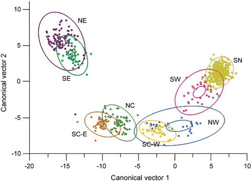
In the overall mixed-model MANOVA, all effects were significant (p < .0001) except rock-glacier classes. The strength of differences was greatest for subregions (). From the discriminant analysis of subregions, the first two canonical vectors (CV) described 87 percent of the variation (Supplemental Table S3). For CV1, the highest correlations in the climate data were with summer precipitation (precipitation; −0.9 > r < −0.8), followed by positive correlations with winter precipitation (0.5 > r < 0.6) and negative correlations (−0.6 > r < −0.5) with summer maximum temperature (Tmax) and minimum vapor pressure deficit (VPD). In CV2, July dewpoint had the strongest correlations (r = 0.73), followed by annual and winter precipitation (0.4 > r < 0.5).
Figure 4. Discriminant analysis of subregions in the hydrographic Great Basin ( for subregion names) and twenty-five PRISM climate variables ( for variables). Dots are PRISM climate tiles containing rock-glacier sites; overlapping sites are contained in many of the single dots: NE = purple; SE = green; SC-E = brown; SC-W = gold; NC = light green; NW = blue; SW = pink; SN = yellow-green. Larger ellipsoids indicate 50 percent concentration of the points; smaller (inner) ellipsoids indicate 95 percent confidence intervals of the class means. The mean misclassification rate was 1.4 percent.
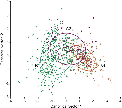
Discriminant analysis of the rock-glacier classes alone resolved highly significant climate differences between individual classes (p < .0001; , Supplemental Table S2). The strongest climate correlations (|0.6| > r < |0.8|), were with winter precipitation (positive; A1, highest values), annual Tmax and summer Tmax (negative; A1, lowest values for both), and maximum VPD (negative; A1, lowest values); summer Tmin had slightly lower and negative correlations (r ~ −0.6). The first CV explained 91 percent of the variation. Climate means illustrate the strong differentiation among rock-glacier classes and subregions (). Annual precipitation was greatest in the SN (Sierra Nevada), NE, and northwest (NW) subregions, and least in the southwest (SW), south-central east (SC-E), and south-central west (SC-W). Precipitation overall was low (mean 1,010 mm, range 583–1,074 mm). Higher summer precipitation distinguished the NE, SC-E, SC-W, and southeast (SE) subregions, whereas high winter precipitation distinguished the NE, NW, and SN. Overall mean annual air temperature (MAAT) was 1.7°C, with highest MAATs in the NW and SC-W subregions (3.3°C and 2.7°C, respectively) and lowest in the SN and SE (1.3°C and 1.5°C, respectively). Climate means differed among rock-glacier classes, with ranking as expected for active, inactive, and relict classes (). Active rock glaciers were located in wettest, coldest, and most humid locations; relict features had the opposite and inactive were intermediate. MAAT was 0.6°C for active features, 1.6°C for inactive, and 2.2°C for relict rock glaciers.
Figure 5. Discriminant analysis of rock-glacier condition classes in the hydrographic Great Basin and twenty-five PRISM climate variables (see Table 3). Dots are PRISM climate tiles containing rock-glacier sites; overlapping sites are contained in many of the single dots. Class A1 (active) = brown; class A2 (inactive) = purple; class R (relict) = green. Larger ellipsoids indicate 50 percent concentration of the points; smaller (inner) ellipsoids indicate 95 percent confidence intervals of the class means. The mean misclassification rate was 39 percent.
Water volume of rock glaciers and ice fields
The volume of water in intact rock glaciers was estimated to be 0.8924 km3 overall for the GB (). Rock glaciers in the Sierra Nevada (central and south combined) contained the highest fraction of water (78.2% of total), followed by the Wasatch Mountains (12.2%), White Mountains (1.8%), Fish Lake Mountains (1.6%), Jarbidge Range (1.3%), and Uinta Mountains (1.2%). The remaining ranges each contained less than 1 percent of the total. The active class had significantly greater water content than inactive (p < .003). In that our assumptions about rock-glacier origins likely yield low estimates of water content, for comparison we also calculated water content under the assumption that all intact cirque rock glaciers in our inventory were debris-covered glaciers, with 75 percent ice content. This yields a 66 percent increase in water stored for those features, or a cumulative increase in water volume from GB rock glaciers of 0.0162 km3.
Table 3. Summary of mean climatic data by subregions, rock-glacier condition class, and overall for the Great Basin (GB). Data extracted from PRISM climate model (1981–2010 normals, Daly, Neilson, and Phillips Citation1994). Subregions: NC = north-central; NE = northeast; NW = northwest; SC-E = south-central east; SC-W = west-central west; SE = southeast; SN = Sierra Nevada; SW = southwest. Classes: A1 = active; A2 = inactive; R = relict.
Table 4. Water volume estimated for rock glaciers and persistent ice fields of the Great Basin. For rock glaciers, volume was calculated only for features assessed as intact (condition classes A1 or A2). Blank cells indicate mountain ranges without active rock glaciers or without ice fields.
Persistent ice fields for the GB overall were estimated to contain 0.0653 km3 of water (), with 99 percent deriving from the central and southern Sierra Nevada. The amount of water contained in GB rock glaciers, thus, represented 93 percent of the total water content from rock glaciers and ice fields for the GB (0.9577 km3). Ratios of rock glacier to ice-field water volume were strongly skewed to excess in rock glaciers (overall, 14:1; ). The lowest ratios were for the Sierra Nevada south, Warner Mountains, and Sierra Nevada central (8:1, 15:1, and 19:1, respectively), whereas for ranges in the interior GB, ratios were very high, with the largest for the Tushar Mountains and White Mountains (3,138:1, 4,082:1, respectively). Excluding the Sierra Nevada, rock glaciers in the remaining mountain ranges contributed 99.5 percent of the total water volume (1,968.9 km3 × 104). The Wasatch Mountains contained more than three times as much water in ice fields as any of the other interior ranges, with the Jarbidge Range, Ruby Mountains, and Uinta Mountains next in importance.
Discussion and conclusions
Distribution and water volume
We present the first comprehensive inventory and analysis of rock glaciers in the Great Basin, United States, documenting 842 features across thirty-two mountain ranges, which collectively cover 83.1 km2 and encompass 8° latitude (from 36.5°N to 44.3°N) and 11° longitude (from −110.7°W to −121.4°W). Rock glaciers contribute 1.1 percent of total mountain area above the lowest rock-glacier elevation by range in the GB. This compares to 1.4 percent in the dry Chilean Andes, 5–7.7 percent in other parts of the Andes, and 0.3 percent in the humid Swiss Alps (from Azócar and Brenning Citation2010). Not surprising for its size, extent of area above 3,000 m, and exposure to moisture-laden winter storms from the Pacific Ocean, the Sierra Nevada strongly biased the total number of GB features (55%). Less expected was that the remaining 45 percent were relatively evenly distributed across the thirty-one interior ranges. Unexpected for this semiarid region was the estimate that 45 percent of the total GB features were intact (containing ice). Of those, 72 percent were in the Sierra Nevada while the remaining 28 percent (106) were distributed across fifteen other mountain ranges. Subregional variability, with a high density of rock glaciers in some areas and a low density in others, occurs in mountain regions elsewhere; for example, the Andes (Azócar and Brenning Citation2010), where topography, geology, and climate vary spatially, as these conditions do in the GB.
The rock-glacier inventory and assessment of activity enabled us to estimate a total water equivalent for the GB from ice within intact rock glaciers of 0.8924 km3. For ranges with intact rock glaciers, the GB water volume translates to 0.136 km3 of water per 1,000 km2 mountain area above the lower rock-glacier elevation. Whereas this is about half the ratio calculated for the Andes of Santiago (0.3 km3 per 1,000 km2; Brenning Citation2005), the ratio for the Sierra Nevada portion of the GB (0.264 km3 per 1,000 km2) closely corresponds to the Andes. To compare the relative significance of water in rock glaciers, we also estimated water volume from persistent ice fields, which required first developing a comprehensive inventory of those features. Although an inventory of glaciers exists for western North America (Glaciers of the American West, http://glaciers.us), and the Sierra Nevada has been intensively surveyed (Basagic and Fountain Citation2011), small persistent ice fields have otherwise not been surveyed for GB mountains. Although previously only one glacier (Wheeler Glacier, now assumed melted) has been known to occur beyond the Sierra Nevada, of the 237 total ice fields we mapped, 24 percent occurred in twelve ranges of the GB other than the Sierra Nevada. Although ice fields in the Sierra Nevada attain moderate size (twenty-three were greater than 0.05 km2; three were greater than 0.3 km2), in other ranges, they were very small. The largest were in the Jarbidge Range (0.007 km2), Snake Range (0.008 km2), Uinta Mountains (0.011 km2), and Wasatch Mountains (0.02 km2).
Overall, the water equivalent from ice fields (0.0653 km3) represents a miniscule contribution to GB hydrology. The rock-glacier water contribution, modest as the values we estimated were, is fourteen times more than icefields (93 percent of the combined total). Further, the contribution from rock glaciers might be much larger than our estimates if in fact some or many of our mapped cirque rock glaciers are of glacial origin and thus contain much more ice than the equations we use assume. At the global scale, Jones et al. (Citation2018) estimated the ratio of rock glacier to glacier water equivalent for seventeen rock-glacier regions on six continents, and, in contrast to the GB, found all ratios indicating that rock glaciers contribute little compared to glaciers—the global ratio, excluding polar regions, was 1:456. The smallest ratios were for North Asia (1:26) and Central Europe (1:33). Among individual mountain regions where this ratio has been calculated, only the dry Chilean Andes between 30°S and 31°S had an excess of water in rock glaciers (8.3:1; Azócar and Brenning Citation2010), although that ratio is still much less than for the GB.
Geographic and climatic relationships
As found in other regions, rock glaciers occupy a consistent geographic niche in GB mountains. Johnson, Thackray, and Van Kirk (Citation2007) considered high elevation, north aspect, and low solar insolation necessary for the presence of rock glaciers in the Lemhi Range of Idaho, just north of the GB, and these conditions are commonly observed in other regions (Brazier et al. Citation1998; Janke Citation2007; Azócar and Brenning Citation2010; Wang et al. Citation2017). Rock glaciers in the GB generally occurred in high, northerly aspect locations; but, in contrast to the Lemhi Range, these were not necessary conditions. Fifty percent of relict features and 34 percent of intact features occurred on non-northerly aspects. This more closely follows the observations of Ran and Liu (Citation2018), who mapped rock glaciers in the southeastern Tibetan Plateau as generally northerly, but with other aspects represented. They observed, as we found in the GB, that cirque rock glaciers (RGC) were more likely northerly than talus forms (RGV). This is the case even though GB cirques often have easterly orientation, because of the regular north-south orientation of GB ranges. Rock glaciers often occupy a northerly orientation within the cirques in those cases.
Similar to surveys in other regions (Brazier, Kirkbride, and Owens Citation1998; Janke Citation2007; Johnson, Thackray, and Van Kirk Citation2007), the three activity classes hypothesized during the GB mapping exercise resolved geographic distinctions in analysis, with features scored as active located higher and on more northerly aspects than inactive features, and these were followed by relict forms. The condition of the rock-glacier forefields, whether springs, streams, lakes, tarns, wetlands, or dry upland vegetation, also usefully distinguished rock-glacier activity, with wet and wetland attributes characterizing intact features. These attributes are not commonly included in other surveys, and we recommend they be added because they are easy to distinguish from imagery, pertain to the condition and diversity of the terrestrial and aquatic communities supported by the rock glaciers, and thus allow an assessment of upland ecosystem health as well as the hydrologic activity of the rock glacier.
Other attributes did not differ as consistently among the activity classes. The angle of the rock-glacier fronts, long considered an indication of the presence or absence of internal ice (Wahrhaftig and Cox Citation1959), differed weakly among the activity classes. Further, although some features had over-steepened fronts, in general the angles (= 29° for intact rock glaciers) were smaller than those found in other regions, and fronts of intact features did not always attain threshold angles of repose (~30–45° for substrates and textures in the GB; Al-Hashemi and Al-Amoudi Citation2018). Angles much steeper than in the GB (35–43°) have been reported from other rock-glacier regions (Burger, Degenhardt, and Giardino Citation1999; Brenning Citation2005). Lower angles might be because of the coarse nature of GB rock-glacier clasts, with a small proportion of fine sediments and generally dry substrates, meaning that the fronts are more likely to release than those with small clasts bound by wet soils.
Although GB rock glaciers occupied cold and wet environments within the context of the GB, MAAT was at the warm end of values reported for rock glaciers in other parts of the world. Haeberli and Burn (Citation2002) gave warm limits for discontinuous permafrost of from −3°C to −8°C at the range of GB precipitation (500–1,000 mm), while Harris (Citation1981) concluded that for regions with less than 50 cm annual snowpack (as is much of GB mountain regions), permafrost requires a MAAT less than 0°C. For the humid Swiss Alps, MAAT less than −1°C characterized intact rock glaciers (Barsch Citation1977, Citation1996). By contrast, the MAATs of GB rock glaciers for all subregions and activity classes were positive, with a high for the northwest subregion of 3.3°C. The GB intact rock-glacier MAAT overall of 1.1°C was above the threshold temperature for the lowest rock-glacier elevation in the southern Chilean Andes (0.5–1.0°C), although higher temperatures were found (4°C) to characterize this threshold farther north in the Andes (Azócar and Brenning Citation2010). Warm MAATs that nonetheless support cold internal rock glacier and talus matrix temperatures with permafrost in the eastern Sierra Nevada have been observed previously, where unique ventilation was implicated (Millar and Westfall Citation2008; Millar, Westfall, and Delany Citation2013, Citation2014). For these and other reasons, rock glaciers are known to depress regional discontinuous permafrost elevations by as much as 1,000 m (Morard, Delaloye, and Lambiel Citation2010).
Temperatures extracted from recent GB PRISM data might be in disequilibrium with thresholds under which ice in rock glaciers formed or temperatures that maintain intact features. During the past century, minimum air temperatures have risen in GB mountains by 1–4°C (Chambers Citation2008; Millar et al. Citation2015a). For California, average minimum summer temperatures rose by 0.1°C per decade from 1895 to 2018, with the pace of warming post-2000 accelerating to 0.7°C per decade (NOAA Citation2018). Despite insulation from rocky mantles on rock glaciers, rock glaciers eventually lose ice and become relict. Current temperatures might well already be warm enough to initiate melting trends. How long it would take for GB intact rock glaciers to melt—albeit at a slow pace governed by the rate of ice melt beneath and within a rocky mantle—is not estimable given large uncertainties and many unknowns, including at least the depth of the mantle, inner matrix temperatures, and the extent and thickness of the embedded ice.
Uncertainties
The findings in this article are presented as preliminary in recognition of potential errors and biases. Important sources of uncertainty include but are not limited to the following: Cartographic resolution of GEP (distances, elevation, resolution of imagery) and differences in resolution between dates of imagery, and mapping errors of omission, commission, and misidentification, and errors of classification (including scoring rock glaciers versus debris-covered glaciers and intact versus relict forms; for ice-field errors in mapping persistent ice versus annual snow patches). Biased estimates of water volume could derive from errant assumptions of ice in features mapped as active and inactive as well as features having different origins (debris-covered glacier versus periglacial), the amount and distribution of ice within rock glaciers (ice lenses; rocky permafrost, or massive ice), and of rock-glacier and ice-field thicknesses. To address some of these sources of error, we re-mapped 20 percent of the GB mountain range area in GEP and observed 31 percent of GEP-mapped features in the field. Our strategy for scoring rock glaciers as intact versus relict included an initial calibration phase based on a large number of rock glaciers known to be active. The equation for estimating water content was derived from conditions pertaining to Andean Mountain rock glaciers, and differences in GB conditions might introduce bias. This equation, and assumptions regarding estimations of ice volume, however, followed those used in the recent literature for rock glaciers of many continents (Jones et al. Citation2018).
Concerns have been raised about errors inherent in the PRISM climate model (Oyler et al. Citation2015). When used as intended (Daly, Neilson, and Phillips Citation1994), modeled data have been found to be highly accurate if systematically slightly biased (Strachan and Daly Citation2017). In past research we compared observed temperatures from data loggers in the vicinity of periglacial taluses to PRISM-extracted data and found small but consistent biases in some variables. We also found that PRISM was able to model GB microclimates including a cold-air drainage well (Millar, Westfall, and Delany Citation2014).
Hydrologic and thermal significance of rock glaciers
The significance of rock glaciers as hydrologic reserves in the GB must be considered relative to contributions from other sources. Relative to persistent ice fields (including glaciers) mapped in this study, their contribution is large. Beyond the Sierra Nevada, however, there was no prior expectation that ice fields occurred in the GB at all, so our finding of many small features scattered across ranges of the interior GB amounts to a new additional, if tiny, source of upland water. By the small cumulative amount of ice-field water, rock-glacier water volume appears very large. More important for comparison is the contribution of rock-glacier water relative to annual snowpack and its discharge. Although those calculations are beyond the scope of this study, qualitative expectations regarding rock glaciers can be considered as follows.
While snowpack and groundwater reservoirs are no doubt the major sources of water in the GB, under warming climates annual snowpacks in this region as elsewhere have been declining and are projected to continue to diminish (Chambers Citation2008; Mote et al. Citation2018; Reich et al. Citation2018). Even without major changes in future annual precipitation, the snowline will continue to rise in elevation such that less precipitation in winter falls as snow, and thus less water is stored as snow for warm-season discharge (Reich et al. Citation2018). Warming temperatures further increase evaporation thresholds such that exposed ice and water bodies are subject to increasing loss. Mountain reservoirs such as rock glaciers that discharge water persistently through the warm season will have an increasingly disproportionate role in delivering water, especially late in the season (Azócar and Brenning Citation2010; Colombo et al. Citation2018; Jones et al. Citation2019). Such activity has been observed in GB rock-glacier springs, which also remained active throughout periods of prolonged drought when other springs desiccated (Millar, Westfall, and Delany Citation2013). Under warming climates, rock glaciers may be expected to release more water late in the warm season, as eventually their ice stores will experience greater melt (Janke, Bellisario, and Ferrando Citation2015; Rangecroft, Harrison, and Anderson Citation2015; Rangecroft et al. Citation2016; Jones et al. Citation2019).
Seasonal lag in ice melt within the matrices of rock glaciers is influenced not only by insulation from rocky mantles but also as a result of internal ventilation processes in these landforms (Wicky and Hauck Citation2017). The structure of the coarse, open matrix of the mantle produces convection that is partially decoupled from the external atmosphere and over-cools the matrices relative to external air, especially in the summer (Morard, Delaloye, and Lambiel Citation2010), as has been documented for GB features (Millar, Westfall, and Delany Citation2014). This occurs independently of the presence of ice, yet feeds back to promote the freezing of water and the persistence of ice once formed. Even in features without embedded ice, therefore, temperatures within rock glaciers are significantly cooler than outside air temperatures, which in turn reduces the evaporation of the water that percolates or collects under and within the mantle (Jones et al. Citation2019). Thus, while many rock glaciers in the interior GB are relict forms and unlikely to contain persistent ice, their insulated condition and ventilated interiors mean that annual snow and precipitation are retained seasonally, and they contribute disproportionately to dry upland slopes as water sources (Burger, Degenhardt, and Giardino Citation1999; Geiger et al. Citation2014; Wagner, Pauritsch, and Winkler Citation2016; Harrington, Hayashi, and Kurylyk Citation2017). The annual temperature disequilibria of rock glaciers relative to external air can translate into decades or centuries in lag of melting under extended periods of warming, especially for the thicker features (Osterkamp and Romanovsky Citation1999; Haeberli et al. Citation2006).
Relative to other upland sources, rock-glacier springs maintain cooler water temperatures with little diurnal fluctuation (Krainer and Mostler Citation2002; Harrington, Hayashi, and Kurylyk Citation2017). In the GB, water temperatures from rock glaciers also are colder than springs from non-glacial sources (Millar, Westfall, and Delany Citation2013), and rock-glacier meltwater temperatures in the Sierra Nevada are only slightly different from those of glaciers (Fegel et al. Citation2016). Cold water temperatures result not only from melting ice within the landforms but also from the ventilated, cool interiors that keep liquid water cool (Millar, Westfall, and Delany Citation2014). Rock-glacier seeps and springs maintain cool water temperatures even in streams below the landforms and into late summer (Burger, Degenhardt, and Giardino Citation1999; Millar, Westfall, and Delany Citation2013; Fegel et al. Citation2016; Harrington, Hayashi, and Kurylyk Citation2017). Cold and persistent springs suggest that rock-glacier-derived waters may be an important previously unrecognized factor in supporting cold-adapted fauna in streams and lakes, especially in warm, semiarid regions such as the GB where water temperatures otherwise are high (Mania et al. Citation2018). While this connection has been little investigated, the persistence of cold-water-requiring stream-form Lahontan cutthroat trout (Oncorhynchus clarki henshawi), stranded in headwater streams of high GB mountain ranges (Coffin and Cowan Citation1995), suggest a possible linkage. To the extent that aquatic fauna in the GB depend on cold water, rock-glacier springs may become increasingly important as climate refugia (Isaak et al. Citation2015), providing locations for survival despite the regional warming of other waters. In addition to lotic and lentic environments, wetlands associated with rock glaciers support the development and persistence of cool-wet-adapted plant and invertebrate communities, adding to their importance as climate refugia (Burga et al. Citation2004; Millar et al. Citation2015b; Tampucci et al. Citation2017). Water emanating from rock glaciers differs significantly in biochemical properties from glacial discharge in pH, metal, nutrient, and microbial characteristics (Fegel et al. 2013), which could affect their value to plants, animals, and downstream human communities, and should be considered in assessments.
Aside from hydrologic roles, the unique ventilation and cooling processes of rock-glacier matrices provide buffered habitat for a range of cool-adapted terrestrial biota (Gobbi et al. Citation2014) that otherwise are rare in dry uplands. Thermally sensitive, cool-adapted American pikas (Ochotona princeps), for instance, are restricted to cool talus matrices for habitat. Talus characteristics enable this small mammal to thrive across GB mountains and persist despite external warming (Millar et al. Citation2018). Plant species growing on the mantles of intact and relict rock glaciers in the GB as elsewhere reflect cool adaptations typical of elevations that are significantly higher than the rock glaciers, and represent regionally endemic diversity (Fickert et al. Citation2007; Millar et al. Citation2015b).
The hydrologic dynamics and broader refugial potential of rock glaciers are of particular relevance in arid and warm-temperate regions (Burger, Degenhardt, and Giardino Citation1999; Brenning Citation2005; Rangecroft, Harrison, and Anderson Citation2015) such as the GB, where rapidly melting glaciers (McCabe and Fountain Citation2013; Vaughan et al. Citation2013) and diminishing annual snowpacks (Mote et al. Citation2018) result in hydrologic deficits with impacts on water resources, including dependent human communities and ecosystems. This is especially severe for regions such as the GB with extended summer drought (e.g., Mediterranean climates). To date, regional water storage and stream discharge volumes have not been included in GB hydrologic or ecologic modeling or projections under climate change. Thus, volumes of water storage are likely underestimated. Inclusion of rock-glacier sources in models might improve water-balance calculations. Further, ecological assessments of GB upland terrestrial and aquatic ecosystems have not included the potential roles of rock-glacier environments or wetlands, especially important under changing climates. Greater understanding of the extent of rock glaciers across semiarid regions such as the GB, and their ecological and hydrologic significances, should improve projections about future conditions, enabling more informed decision making by resource managers and conservationists.
Supplemental Material
Download Zip (3 MB)Acknowledgments
The authors thank Doug Clark (Western Washington University), Andrew Fountain (Portland State University), Greg Stock (Yosemite National Park), and Wally Woolfenden (U.S. Forest Service, retired) for helpful discussions about rock glaciers over many years. We also thank Diane Delany for rendering the figures and Chrissy Howell (U.S. Forest Service) for reviewing the draft manuscript. We especially thank Robert Anderson and an anonymous reviewer for valuable critique of the submitted manuscript.
Disclosure statement
No potential conflict of interest was reported by the authors.
Supplementary material
Supplemental data for this article can be accessed here.
Additional information
Funding
Related Research Data
References
- Al-Hashemi, H. M. B., and O. S. B. Al-Amoudi. 2018. A review on the angle of repose of granular materials. Powder Technology. doi:10.1016/j.powtec.2018.02.003.
- Anderson, R. S., L. S. Anderson, W. H. Armstrong, M. W. Rossi, and S. E. Crump. 2018. Glaciation of alpine valleys: The glacier-debris-covered glacier-rock-continuum. Geomorphology 311:127–42. doi:10.1016/j.geomorph.2018.03.015.
- Azócar, G. F., and A. Brenning. 2010. Hydrological and geomorphological significance of rock glaciers in the dry Andes, Chile (27–33 S). Permafrost and Periglacial Processes 21:42–53. doi:10.1002/ppp.669.
- Barsch, D. 1977. Nature and importance of mass-wasting by rock glaciers in alpine permafrost environments. Earth Surface Processes 2:231–45. doi:10.1002/esp.3290020213.
- Barsch, D. 1992. Permafrost creep and rockglaciers. Permafrost and Periglacial Processes 3:175–88. doi:10.1002/ppp.3430030303.
- Barsch, D. 1996. Rock glaciers; Indicators for the present and former geoecology in high mountain environments. Berlin: Springer.
- Basagic, H. J., and A. G. Fountain. 2011. Quantifying 20th century glacier change Sierra Nevada, California. Arctic, Antarctic, and Alpine Research 43:317–30. doi:10.1657/1938-4246-43.3.31.
- Blackwelder, E. 1931. Pleistocene glaciation in the Sierra Nevada and Basin Ranges. Bulletin of the Geological Society of America 42:865–922. doi:10.1130/GSAB-42-865.
- Bowerman, N. D., and D. H. Clark. 2011. Holocene glaciation of the central Sierra Nevada, California. Quaternary Science Reviews 30:1067–85. doi:10.1016/j.quascirev.2010.10.014.
- Brazier, V., M. P. Kirkbride, and I. F. Owens. 1998. The relationship between climate and rock glacier distribution in the Ben Ohau Range, New Zealand, Geografiska Annaler: Series A, Physical Geography 80:193–207. doi:10.1111/j.0435-3676.1998.00037.x.
- Brenning, A. 2005. Geomorphological, hydrological and climatic significance of rock glaciers in the Andes of Central Chile (33–35° S). Permafrost and Periglacial Processes 16:231–40. doi:10.1002/ppp.528.
- Burga, C. A., R. Frauenelder, J. Ruffet, M. Hoelzle, and A. Kääb. 2004. Vegetation on Alpine active rock glacier surfaces: A contribution to abundance and dynamics on extreme plant habitats. Flora 199:505–15. doi:10.1078/0367-2530-00179.
- Burger, K. C., J. J. Degenhardt, and J. R. Giardino. 1999. Engineering geomorphology of rock glaciers. Geomorphology 31:93–132. doi:10.1016/S0169-555X(99)00074-4.
- Chambers, J. C. 2008. Climate change and the Great Basin. In Collaborative management and research in the Great Basin - examining the issues and developing a framework for action, ed. J. C. Chambers, N. Devoe, and A. Evenden, 29–32. Gen. Tech. Rep. RMRS-GTR-204, Fort Collins, CO: U.S. Department of Agriculture, Forest Service, Rocky Mountain Research Station.
- Charlet, D. A. 1996. Atlas of Nevada conifers. A phytogeographic reference, 319. Reno, Nevada: University of Nevada Press.
- Chen, J., and A. Ohmura. 1990. Estimation of Alpine glacier water resources and their change since the 1870s. In Hydrology in mountainous regions. I – hydrological measurements: The water cycle, proceedings of two Lausanne symposia, ed. H. Lang and A. Musy, Vol. 193, 127–35. Wallingford, UK: IAHS Press.
- Clark, D. H., M. M. Clark, and A. R. Gillespie. 1994. Debris-covered glaciers in the Sierra Nevada, California, and their implications for snowline reconstructions. Quaternary Research 41:139–53. doi:10.1006/qres.1994.1016.
- Clark, D. H., and A. R. Gillespie. 1997. Timing and significance of late-glacial and Holocene cirque glaciation in the Sierra Nevada, California. Quaternary International 38:21–38. doi:10.1016/S1040-6182(96)00024-9.
- Clark, D. H., E. G. Steig, N. Potter Jr., J. Fitzpatrick, A. B. Updike, and M. G. Clark. 1996. Old ice in rock glaciers may provide long-term climate records. Eos 77:217–22. doi:10.1029/96EO00149.
- Clark, D. H., E. J. Steig, N. Potter, and A. R. Gillespie. 1998. Genetic variability of rock glaciers. Geografiska Annaler 80:175–82. doi:10.1111/j.0435-3676.1998.00035.x.
- Coats, R. R. 1964. Geology of the Jarbridge Quadrangle, Nevada-Idaho. 1141-M, 28. Geological Survey Bulletin. Washington, DC: US GPO.
- Coffin, P. D., and W. F. Cowan. 1995. Lahontan cutthroat trout (Oncorhynchus clarki henshawi) recovery plan. Portland, Oregon: U. S. Fish and Wildlife Service, Region I.
- Colombo, N., L. Sambuelli, C. Comina, C. Colombero, M. Giardino, S. Gruber, G. Viviano, L. Vittori Antisari, and F. Salerno. 2018. Mechanisms linking active rock glaciers and impounded surface water formation in high‐mountain areas. Earth Surface Processes and Landforms 43:417–31. doi:10.1002/esp.v43.2.
- Daly, C. R., R. P. Neilson, and D. L. Phillips. 1994. A statistical-topographic model for mapping climatological precipitation over mountainous terrain. Journal of Applied Meteorology 33:140–58. doi:10.1175/1520-0450(1994)033<0140:ASTMFM>2.0.CO;2.
- Ellis, J. M., and P. E. Calkin. 1979. Nature and distribution of glaciers, neoglacial moraines, and rock glaciers, east-central Brooks Range, Alaska. Arctic and Alpine Research 11:403–20. doi:10.1080/00040851.1979.12004149.
- ESRI (Environmental Systems Research Institute). 2015. ArcGIS 10.3.1 for desktop. Redlands, CA: Environmental Systems Research Institute.
- Fegel, T. S., J. S. Baron, A. G. Fountain, G. F. Johnson, and E. K. Hall. 2016. The differing biogeochemical and microbial signatures of glaciers and rock glaciers. Journal of Geophysical Research: Biogeosciences 121:919–32. doi:10.1002/2015JG003236.
- Fickert, T., D. Friend, F. Grüninger, B. Molnia, and M. Richter. 2007. Did debris-covered glaciers serve as Pleistocene refugia for plants? A new hypothesis derived from observations of recent plant growth on glacier surfaces. Arctic, Antarctic, and Alpine Research 39:245–57. doi:10.1657/1523-0430(2007)39[245:DDGSAP]2.0.CO;2.
- Geiger, S. T., J. M. Daniels, S. N. Miller, and J. W. Nicholas. 2014. Influence of rock glaciers on stream hydrology in the La Sal Mountains, Utah. Arctic, Antarctic, and Alpine Research 46:645–58. doi:10.1657/1938-4246-46.3.645.
- Gobbi, M., F. Ballarin, C. Compostella, V. Lencioni, R. Seppi, D. Tampucci, and M. Caccianiga. 2014. Physical and biological features of an active rock glacier in the Italian Alps. The Holocene 24:1624–31. doi:10.1177/0959683614544050.
- Graham, J. P. 2014. Great Basin National Park; Geologic resources inventory report. Natural Resource Report NPS/NRSS/GRD/NRR-2014/762, National Park Service, Natural Resource Stewardship and Science, 95.
- Grayson, D. K. 2011. The Great Basin. A natural prehistory. A natural prehistory, 418. Berkeley, CA: University of California Press.
- Haeberli, W., and C. R. Burn. 2002. Natural hazards in forests: Glacier and permafrost effects as related to climate. Environmental Change and Geomorphic Hazards in Forests 9:167.
- Haeberli, W., B. Hallet, L. Arenson, R. Elconin, O. Humlum, A. Kääb, V. Kaufmann, B. Ladanyi, N. Matsuoka, S. Springman, et al. 2006. Permafrost creep and rock glacier dynamics. Permafrost and Periglacial Processes 17:189–214. doi:10.1002/ppp.561.
- Harrington, J. S., M. Hayashi, and B. Kurylyk. 2017. Influence of a rock glacier spring on the stream energy budget and cold‐water refuge in an alpine stream. Hydrological Processes 31:4719–33. doi:10.1002/hyp.11391.
- Harris, S. A. 1981. Climatic relationships of permafrost zones in areas of low winter snow-cover. Arctic 34(1):64–70. https://www.jstor.org/stable/40509106.
- Hausmann, H., K. Krainer, E. Brückl, and W. Mostler. 2007. Internal structure and ice content of Reichenkar rock glacier (Stubai Alps, Austria) assessed by geophysical investigations. Permafrost and Periglacial Processes 18:351–67. doi:10.1002/ppp.601.
- Hausmann, H., K. Krainer, E. Brückl, and C. Ullrich. 2012. Internal structure, ice content and dynamics of Ölgrube and Kaiserberg rock glaciers (Ötztal Alps, Austria) determined from geophysical surveys. Austrian Journal of Earth Sciences 105:12–31.
- Isaak, D. J., M. K. Young, D. E. Nagel, D. L. Horan, and M. C. Groce. 2015. The cold‐water climate shield: Delineating refugia for preserving salmonid fishes through the 21st century. Global Change Biology 21:2540–53. doi:10.1111/gcb.12879.
- Ives, R. L. 1950. Glaciations in Little Cottonwood Canyon, Utah. The Scientific Monthly 71:105–17.
- Janke, J. R. 2007. Colorado Front Range rock glaciers: Distribution and topographic characteristics. Arctic, Antarctic, and Alpine Research 39:74–83. doi:10.1657/1523-0430(2007)39[74:CFRRGD]2.0.CO;2.
- Janke, J. R., A. C. Bellisario, and F. A. Ferrando. 2015. Classification of debris-covered glaciers and rock glaciers in the Andes of central Chile. Geomorphology 241:98–121. doi:10.1016/j.geomorph.2015.03.034.
- Johnson, B. G., G. D. Thackray, and R. Van Kirk. 2007. The effect of topography, latitude, and lithology on rock glacier distribution in the Lemhi Range, central Idaho, USA. Geomorphology 91:38–50. doi:10.1016/j.geomorph.2007.01.023.
- Johnson, P. G. 1983. Rock glaciers. A case for a change in nomenclature. Geografiska Annaler: Series A, Physical Geography 65:27–34. doi:10.1080/04353676.1983.11880071.
- Jones, D. B., S. Harrison, K. Anderson, and R. A. Betts. 2018. Mountain rock glaciers contain globally significant water stores. Scientific Reports 8:2834. doi:10.1038/s41598-018-21244-w.
- Jones, D. B., S. Harrison, K. Anderson, and W. B. Whalley. 2019. Rock glaciers and mountain hydrology: A review. Earth-Science Reviews 193:66–90. doi:10.1016/j.earscirev.2019.04.001.
- Kääb, A., R. Frauenfelder, and I. Roer. 2007. On the response of rockglacier creep to surface temperature increase. Global and Planetary Change 56:172–87. doi:10.1016/j.gloplacha.2006.07.005.
- Kesseli, J. E. 1941. Rock streams in the Sierra Nevada, California. Geographical Review 31:203–27. doi:10.2307/210204.
- Knight, J., S. Harrison, and D. B. Jones. 2019. Rock glaciers and the geomorphological evolution of deglacierizing mountains. Geomorphology 324:14–24. doi:10.1016/j.geomorph.2018.09.020.
- Krainer, K., and W. Mostler. 2002. Hydrology of active rock glaciers: Examples from the Austrian Alps. Arctic, Antarctic, and Alpine Research 34:142–49. doi:10.1080/15230430.2002.12003478.
- Liu, L., C. I. Millar, R. D. Westfall, and H. A. Zebker. 2013. Surface motion of active rock glaciers in the Sierra Nevada, California, USA: Inventory and a case study using InSAR. The Cryosphere 7:1109–19. doi:10.5194/tc-7-1109-2013.
- Madsen, D. B., and D. R. Currey. 1979. Late Quaternary glacial and vegetation changes, Little Cottonwood Canyon area, Wasatch Mountains, Utah. Quaternary Research 12:254–70. doi:10.1016/0033-5894(79)90061-9.
- Mania, I., R. Gorra, N. Colombo, M. Freppaz, M. Martin, and A. M. Anesio. 2018. Prokaryotic diversity and distribution in different habitats of an alpine rock glacier-pond system. Microbial Ecology 1–15. doi:10.1007/s00248-018-1272-3.
- Martin, H. E., and W. B. Whalley. 1987. Rock glaciers. Part 1: Rock glacier morphology, classification, and distribution. Progress in Physical Geography 11:260–82. doi:10.1177/030913338701100205.
- McCabe, G. J., and A. G. Fountain. 2013. Glacier variability in the conterminous United States during the twentieth century. Climatic Change 116:565–77. doi:10.1007/s10584-012-0502-9.
- Millar, C. I., D. L. Delany, K. A. Hersey, M. R. Jeffress, A. T. Smith, K. J. Van Gunst, and R. D. Westfall. 2018. Distribution, climatic relationships, and status of American pikas (Ochotona princeps) in the Great Basin, USA. Arctic, Antarctic, and Alpine Research 50:e1436296. doi:10.1080/15230430.2018.1436296.
- Millar, C. I., and R. D. Westfall. 2008. Rock glaciers and related periglacial landforms in the Sierra Nevada, CA, USA; inventory, distribution and climatic relationships. Quaternary International 188:90–104. doi:10.1016/j.quaint.2007.06.004.
- Millar, C. I., R. D. Westfall, and D. L. Delany. 2013. Thermal and hydrologic attributes of rock glaciers and periglacial talus landforms: Sierra Nevada, California, USA. Quaternary International 310:169–80. doi:10.1016/j.quaint.2012.07.019.
- Millar, C. I., R. D. Westfall, and D. L. Delany. 2014. Thermal regimes and snowpack relations of periglacial talus slopes, Sierra Nevada, California, USA. Arctic, Antarctic, and Alpine Research 46:483–504. doi:10.1657/1938-4246-46.2.483.
- Millar, C. I., R. D. Westfall, D. L. Delany, A. L. Flint, and L. E. Flint. 2015a. Recruitment patterns and growth of high-elevation pines in response to climatic variability (1883–2013), in the western Great Basin, USA. Canadian Journal of Forest Research 45:1299–312. doi:10.1139/cjfr-2015-0025.
- Millar, C. I., R. D. Westfall, A. Evenden, J. G. Holmquist, J. Schmidt-Gengenbach, R. S. Franklin, J. Nachlinger, and D. L. Delany. 2015b. Potential climatic refugia in semi-arid, temperate mountains: Plant and arthropod assemblages associated with rock glaciers, talus slopes, and their forefield wetlands, Sierra Nevada, California, USA. Quaternary International 387:106–21. doi:10.1016/j.quaint.2013.11.003.
- Morard, S., R. Delaloye, and C. Lambiel. 2010. Pluriannual thermal behavior of low elevation cold talus slopes in western Switzerland. Geographica Helvetica 65:124–34. doi:10.5194/gh-65-124-2010.
- Mote, P. W., S. Li, D. P. Lettenmaier, M. Xiao, and R. Engel. 2018. Dramatic declines in snowpack in the western US. Npj Climate and Atmospheric Science 1:2. doi:10.1038/s41612-018-0012-1.
- NOAA National Centers for Environmental Information, State of the Climate. 2018. National Climate Report for July, published online August 2018. https://www.ncdc.noaa.gov/sotc/national/201807.
- Osborn, G., and K. Bevis. 2001. Glaciation in the Great Basin of the western United States. Quaternary Science Reviews 20:1377–410. doi:10.1016/S0277-3791(01)00002-6.
- Osterkamp, T. E., and V. E. Romanovsky. 1999. Evidence for warming and thawing of discontinuous permafrost in Alaska. Permafrost and Periglacial Processes 10:17–37. doi:10.1002/(SICI)1099-1530(199901/03)10:1<17::AID-PPP303>3.0.CO;2-4.
- Oviatt, C. G. 1994. Quaternary geologic map of the upper Weber River drainage basin, Summit County, Utah. Utah Geological Survey, Map 156. doi:10.3168/jds.S0022-0302(94)77044-2.
- Oyler, J. W., S. Z. Dobrowski, A. P. Ballantyne, A. E. Klene, and S. W. Running. 2015. Artificial amplification of warming trends across the mountains of the western United States. Geophysical Research Letters 42:153–61. doi:10.1002/2014GL062803.
- Phillips, F. M., M. G. Zreda, L. V. Benson, M. A. Plummer, D. Elmore, and P. Sharma. 1996. Chronology for fluctuations in late Pleistocene Sierra Nevada glaciers and lakes. Science 274:749–51. doi:10.1126/science.274.5288.749.
- Piegat, J. J. 1980. Glacial geology of central Nevada. M.S. thesis, Purdue University, 106.
- Ran, Z., and G. Liu. 2018. Rock glaciers in Daxue Shan, south-eastern Tibetan Plateau: An inventory, their distribution, and their environmental controls. The Cryosphere 12:2327–40. doi:10.5194/tc-12-2327-2018.
- Rangecroft, S., S. Harrison, and K. Anderson. 2015. Rock glaciers as water stores in the Bolivian Andes: An assessment of their hydrological importance. Arctic, Antarctic, and Alpine Research 89–98. doi:10.1657/AAAR0014-029.
- Rangecroft, S., A. J. Suggitt, K. Anderson, and S. Harrison. 2016. Future climate warming and changes to mountain permafrost in the Bolivian Andes. Climatic Change 137:231–43. doi:10.1007/s10584-016-1655-8.
- Reich, K. D., N. Berg, D. B. Walton, M. Schwartz, F. Sun, X. Huang, and A. Hall. 2018. Climate change in the Sierra Nevada: California’s water future. Vol. 1–52. University of California Los Angeles, Center for Climate Science, Los Angeles.
- Russell, I. C. 1885. Geological history of Lake Lahontan, a Quaternary lake of northwestern Nevada, U.S. Geological Survey Monograph 11:288.
- SAS Institute, Inc. 2015. JMP® 12.2. Cary, NC: SAS Institute Inc.
- Sharp, R. P. 1938. Pleistocene glaciation in the Ruby-East Humboldt Range, northeastern Nevada. Journal of Geomorphology 1:296–323.
- Sharp, R. P., and J. H. Birman. 1963. Additions to classical sequence of Pleistocene glaciations, Sierra Nevada, California. Geological Society of America Bulletin 74 (8):1079–86. doi:10.1130/0016-7606(1963)74[1079:ATCSOP]2.0.CO;2.
- Stock, G., R. Anderson, T. Painter, B. Henn, and J. Lundquist. 2017. Impending loss of Little Ice Age Yosemite National Park, Paper No. 361-6. Geological Society of America Abstracts with Programs, 49(6). doi: 10.1130/abs/2017AM-299617.
- Strachan, S., and C. Daly. 2017. Testing the daily PRISM air temperature model on semiarid mountain slopes. Journal of Geophysical Research: Atmospheres 122:5697–715. doi:10.1002/2016JD025920.
- Tampucci, D., M. Gobbi, G. Marano, P. Boracchi, G. Boffa, F. Ballarin, P. Pantini, R. Seppi, C. Compostella, and M. Caccianiga. 2017. Ecology of active rock glaciers and surrounding landforms: Climate, soil, plants and arthropods. Boreas 46:185–98. doi:10.1111/bor.12219.
- Vaughan, D. G., J. Comiso, I. Allison, J. Carrasco, G. Kaser, R. Kwok, et al. 2013. Observations: cryosphere in climate change 2013: The physical science basis. In Contribution of working group I to the fifth assessment report of the intergovernmental panel on climate change, ed. T.F. Stocker, et al., 317–82. New York: Cambridge University Press.
- Wagner, T., M. Pauritsch, and G. Winkler. 2016. Impact of relict rock glaciers on spring and stream flow of alpine watersheds: Examples of the Niedere Tauern range, Eastern Alps (Austria). Australian Journal of Earth Science 109:84–98. doi:10.17738/ajes.2016.0006.
- Wahrhaftig, C., and A. Cox. 1959. Rock glaciers in the Alaska Range. Geological Society of America Bulletin 70:383–436. doi:10.1130/0016-7606(1959)70[383:RGITAR]2.0.CO;2.
- Wang, X., L. Liu, L. Zhao, T. Wu, Z. Li, and G. Liu. 2017. Mapping and inventorying active rock glaciers in the northern Tien Shan of China using satellite SAR interferometry. Cryosphere 11:997–1014. doi:10.5194/tc-11-997-2017.
- Wayne, J. W. 1984. Glacial chronology of the Ruby Mountains—East Humboldt Range, Nevada. Quaternary Research 21:286–303. doi:10.1016/0033-5894(84)90069-3.
- Wicky, J., and C. Hauck. 2017. Numerical modelling of convective heat transport by air flow in permafrost talus slopes. The Cryosphere 11:1311–25. doi:10.5194/tc-11-1311-2017.