
ABSTRACT
Arctic lakes are exposed to warming during increasingly longer ice-free periods and, if located in glaciated areas, to increased inflow of meltwater and sediments. However, direct monitoring of how such lakes respond to changing environmental conditions is challenging not only because of their remoteness but also because of the scarcity of present and previously observed lake states. At the glacier-proximal Lake Tarfala in the Kebnekaise Mountains, northern Sweden, temperatures throughout the water column at its deepest part (50 m) were acquired between 2016 and 2019. This three-year record shows that Lake Tarfala is dimictic and is overturning during spring and fall, respectively. Timing, duration, and intensity of mixing processes, as well as of summer and winter stratification, vary between years. Glacial meltwater may play an important role regarding not only mixing processes but also cooling of the lake. Attribution of external environmental factors to (changes in) lake mixing processes and thermal states remains challenging owing to for example, timing of ice-on and ice-off but also reflection and absorption of light, both known to play a decisive role for lake mixing processes, are not (yet) monitored in situ at Lake Tarfala.
Introduction
Surface freshwater environments in the Arctic comprise mainly lakes (87 percent) but also ponds, rivers, streams, and wetland complexes. Together, they can cover more than 80 percent of the land surface in some regions of the Arctic (Wrona et al. Citation2013). Lakes may also be in direct contact with glaciers or receive meltwater from glaciers in their surroundings.
Global warming, currently increasing at 0.2°C/decade on a global average and at rates two to three times higher in the Arctic (Intergovernmental Panel on Climate Change Citation2018), implies that the period during which lakes are ice covered, between ice-on in autumn and ice-off in spring, decreases (Prowse et al. Citation2011; Benson et al. Citation2012; Šmejkalová, Edwards, and Dash Citation2016; Lehnherr et al. Citation2018; Sharma et al. Citation2019). Recent warming has also led to widespread mass loss from ice sheets and glaciers (Intergovernmental Panel on Climate Change Citation2019). This, too, has implications for arctic lakes because they may receive larger amounts of meltwater, sediment, organic matter, and nutrients while glaciers are melting.
Because lake ice cover is often for simplicity linked to air surface temperature only, it has also been suggested that lake water temperatures increase with increasing air temperature (Livingstone and Lotter Citation1998; Dibike et al. Citation2011; Prowse et al. Citation2011). However, it is possible that elevated lake temperatures may not yet be observed in glacier proximal lakes because of the increased influx of cold, glacial meltwater. This raises questions about the relative importance of competing processes governing lake water temperatures and about the implications that ongoing warming may have for water temperature-induced vertical mixing processes in lakes.
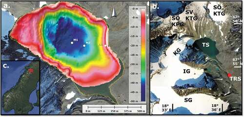
By the year 2100, mass loss from Scandinavian glaciers is projected to amount to more than 80 percent (compared to their mass in 2015, lost at a rate of 2 ± 1 Gt/year during 2006–2015) under Representative Concentration Pathway (RCP) 8.5 (medium confidence), compared to 36 ± 11 percent for global glacier mass loss (Hock et al. Citation2019). In the Kebnekaise Mountains, northern Sweden, Lake Tarfala () is located in a proglacial alpine setting at 1,162 m.a.s.l. The Kebnepakte Glacier, neighboring Storglaciären for which the world’s longest glacier mass balance record is kept, terminated with an ice cliff in Lake Tarfala until 1945 and retreated onto land thereafter (Kirchner et al. Citation2019). With a maximum depth of 49.8 m, Lake Tarfala is exceptionally deep compared to other lakes at similar latitudes and/or altitudes, where mostly paleolimnological studies or short-term surveys of physical, biological, and chemical variables have been conducted (Anderson et al. Citation1999; Massa et al. Citation2012; Weckström et al. Citation2016; Sharma et al. Citation2019). It is also a primary location for studying ongoing lake processes, with potential to extend investigations to focus on past changes (from, e.g., the lake sedimentary record; Catalan et al. Citation2013; Rosqvist et al. Citation2013).
Figure 1. (a) Lake Tarfala, with color-coded high-resolution bathymetry from Kirchner et al. (Citation2019) overlain on orthophoto Rgb050 (GSD 2+ elevation data, Lantmäteriet Citation2015), showing also the terminus of Kebnepakteglaciären, formerly terminating in the northwestern part of Lake Tarfala. Lake level (yellow stippled line) is at 1,162 m.a.s.l. White dots mark mooring sites M1 and M2. At M1, water temperature has been measured at various depths in the water column since 2016. The white diamond marks the site L1 where a StarOddi CTD sensor was moored. (b) The Tarfala area on a regional overview map from Google Earth (image: 10 August 2013) with Lake Tarfala (Tarfalasjön, abbreviated TS) in the center. Red dot marks the location of TRS. Storglaciären (SG), Isfallsglaciären (IG), and Kebnepakteglaciären (KG) are marked, as well as Sydöstra Kaskasapakteglaciären (SÖ KPG), Sydvästra Kaskasatjåkkaglaciären (SV KTG), and Sydöstra Kaskasatjåkkaglaciären (SÖ KTG). Note that Tarfala Bridge is located outside of the area shown in (b). (c) Location of the Tarfala area in northern Sweden (image from Google Earth).
Perhaps more important, the projected high mass loss of the Scandinavian glaciers may render Lake Tarfala a natural observatory where changes in processes, inherent timescales, and impacts in response to competing drivers can be studied before they occur at other glacial lakes sites where glaciers melt at a slower pace. For example, a better understanding of vertical mixing dynamics in Lake Tarfala is not only needed to assess, in forthcoming efforts, how the lakes’ limnological, ecological, and biogeochemical regimes are affected. It can also help inform studies of other glacier-fed arctic lakes, for which timescales of anticipated change caused by glacial melt are different and for which, therefore, the development of new balances between lake carbon emission and burial rates (Lundin et al. Citation2015; Jansen et al. Citation2019) and the passing of thresholds associated with thermal stratification, leading to accelerated biological responses in lakes (Smol et al. Citation2005), could be delayed.
Lake mixing is triggered when temperature-induced density changes lead to sinking of denser water masses and upwelling of less dense water masses (both with respect to the ambient layers). The density of pure water increases nonlinearly between the freezing temperature and 3.98°C, where the maximum density is attained. Above 3.98°C, the density decreases nonlinearly. Essentially the same behavior is observed for natural water; that is, freshwater with practically negligible contents of minerals and hence negligible salinity and conductivity. Mixing is mainly a vertical process, upon termination of which a stable stratification (epilimnion overlying the hypolimnion and separated from it by a metalimnion containing the thermocline as the position of the largest vertical temperature gradient) may or may not be attained (Wetzel Citation2001; Boehrer and Schultze Citation2008; Hutter, Wang, and Chubarenko Citation2011). Depending on the number of mixing processes occurring during an annual cycle, lakes are characterized (Hutchinson Citation1957) as amictic (no mixing) or mono-, di-, or polymictic (mixing once, twice, or many times).
Here, we present the first continuous record (2016–2019) of water temperatures from the deepest part of Lake Tarfala, extending from 2 m below lake surface (mbls) to the lake bottom. Analyzing the temperature record, we identify timing and duration of vertical mixing processes and discuss challenges of attributing external environmental factors and processes to observed interannual variability in the lakes’ thermal state and structure. First results provide a strong motivation for continued measurements of state variables to better understand how arctic lakes respond to the competing impacts of increasing glacial meltwater inflow and warming air temperatures.
Regional setting
Lake Tarfala is a headwater lake in the Tarfala Valley in the Kebnekaise Mountains, northern Sweden (~67°55′ N, ~18°35′ E). Its surface area is ~0.56 km2, and its volume is 11.8 × 10⁶ m3 (Kirchner et al. Citation2019). Lake Tarfala’s catchment area is ~8.5 km2. A natural outlet is located at 1,162 m.a.s.l. at the lake’s southeastern margin (), downstream of which the water is known as Tarfalajokken (Tarfala River). Five glaciers and several perennial snow fields are located in the valley; of these, Kebnepakteglaciär en and Sydöstra Kaskasatjåkkaglaciären drain into Lake Tarfala. Also, meltwaters from Sydöstra Kaskasapakteglaciä ren and a snowfield, formerly Sydvästra Kaskasatjåkkagla-ciären, reach the lake. Tarfala Research Station (TRS) is located ~1 km southeast of Lake Tarfala. Meltwater from Storglaciären drains directly into Tarfalajokken ~1.5 km down valley of TRS.
Intense research on glacier mass balance has been conducted at Storglaciären since 1946 (Grudd and Schneider Citation1996; Holmlund, Karlén, and Grudd Citation1996; Holmlund and Jansson Citation1999), but Lake Tarfala has received considerably less attention. Pioneering investigations focusing on the bathymetry and thermal state of Lake Tarfala were made in 1959 and 1966/1967 (Larje and Nyberger Citation1960; Björklund Citation1967). For Lake Tarfala, the bathymetric information was updated recently to a modern, high-resolution data set (Kirchner et al. Citation2019). Lake water temperature measurements have not been systematically repeated since 1966/1967. Observation of the timing of ice-on and ice-off by means of time-lapse photography was initiated in June 2020. Environmental variables monitored at TRS include air temperature, wind speed and direction, solar irradiance, and (liquid) precipitation. Water level of Tarfalajokken is recorded at Tarfala Bridge, ~6 km down valley of TRS. At Storglaciären, precipitation and glacier surface height are measured.
Methods and data
Water temperature in Lake Tarfala
Four Seabird Scientific SBE56 temperature sensors were arranged in a vertical array to acquire water temperatures at 10, 20, 30, and 40 mbls at the deepest part of Lake Tarfala (67°55′26.5″ N, 18°35′20.6″ E, mooring site M1, water depth 49 m), starting 18 September 2016. A second SBE56 sensor array was moored at site M2 (67°55′25.2″ N, 18°35′30.0″ E, water depth 40 m; see ) from 18 September 2016 to 18 September 2017. At M2, sensors were placed at 10, 20, 30, and 35 mbls. Paired t tests, run in the software R (R Core Team Citation2020) on temperature measurements from the same depth but different locations (M1 and M2), returned a p value of less than 2.2e−16. Therefore, after a 36-hour maintenance period starting 18 September 2017, 12.00 UTC, measurements continued only at site M1 from 20 September 2017. The instruments logged, time-stamped, and saved measured water temperatures every 30 minutes, at a temperature resolution and accuracy of 0.0001°C and ±0.002°C, respectively, and a clock accuracy of ±5 s/month.
Five HOBO Water Temp Pro v2 profilers were attached to the SBE56 mooring at site M1 on 28 April 2019 and acquired water temperature at 2, 4, 6, 8, and 10 mbls every 120 minutes until 5 September 2019. The HOBO profilers have a temperature resolution and accuracy of 0.02°C and ±0.21°C, respectively, and a clock accuracy of ±1 min/month.
A StarOddi DST CTD sensor was moored at site L1 (67°55′25.1″ N, 18°35′47.1 E″, water depth 8 m; ), mbls, between 5 September 2018 and 8 September 2019 and recorded temperatures only, in a shallow part of the lake. The temperature sensor’s range, resolution, and accuracy are −1°C to 40°C, 0.032°C, and ±0.1°C, at a clock accuracy of ±1 min/month.
Conductivity in Lake Tarfala was measured in 2017 to 13.3 μS/cm at 1, 10, and 30 mbls and to 17.5 μS/cm at 50 mbls (SITES data portal Citation2020). These values confirm that Lake Tarfala is comprised of freshwater.
Raw data retrieved from the instruments were processed and visualized with Matlab Citation2019.
Air temperature, wind speed, and solar irradiance at Tarfala Research Station
The temporal resolution of meteorological data from TRS depends on the periods and sources of data acquisition: Monthly means of summer air temperatures (June, July, August) are available between 1946 and 1964. Data between 1946 and 2012, together with relevant metadata (e.g., type of instrumentation), are available at Bolin Centre Database from 2013 onward, meteorological data including air temperature, wind speed, and solar irradiance at TRS were collected every 10 minutes by an automatic weather station (referred to as TRS-AWS). Recent TRS-AWS data are available from SITES (SITES data portal Citation2020). Air temperature, wind speed, and solar irradiance data from TRS-AWS were downsampled to 30 minutes to facilitate comparison with the water temperature data.
Results
Lake water temperatures
The variation in temperatures in Lake Tarfala over time and at different depths is shown in and detailed in and S1. Water temperatures during 2017 and 2018, for which data from the full years (January to December) are available, show that Lake Tarfala can be characterized as dimictic and holomictic (i.e., mixing throughout the entire water column). Its annual cycle is characterized by winter stratification, followed by warming, spring overturning, summer stratification, cooling, fall overturning, and winter stratification. However, timing and duration of mixing periods varies: During 2017, a short period of cooling occurred in the beginning of July, which delayed spring overturning and resulted in a weak and short summer stratification (accomplished around 23 August). Fall overturning was completed by 1 September, whereafter cooling and the formation of winter stratification (characterized by warm, dense bottom waters, overlain by cooler and less dense water; see ) was observed. During 2018, spring overturning was accomplished by mid-July, after which a summer stratification developed (until around 1 August). Fall overturning was completed by the end of September and continued into a winter stratification (see ) characterized by low water temperatures (<2°C at 10 mbls and below) compared to 2016/2017 and 2017/2018 (>3°C at 10 mbls and below; cf. ).
Figure 2. Water temperatures in Lake Tarfala. Colorscale ranges from blue (cold, 0°C) to red (warm, 6.5°C). Temperature data are plotted at a temporal resolution of 2 hours (SBE56 data were downsampled to match the temporal resolution of the HOBO sensor data). Note that no interpolation was carried out in the vertical (implying that water temperatures shown between, e.g., 40 and 31 mbls are the water temperatures measured at 40 mbls and that those shown between 30 and 21 mbls are the temperatures measured at 30 mbls, etc.). (a) Water temperature at various depths (40, 30, 20, 10 mbls) during the period 18 September 2016 to 5 September 2019 at mooring site M1 (see ), based on data acquired every 30 minutes with the exception of a 36-hour maintenance period 18–20 September 2017) by a vertical array of SBE sensors. White cells denote unavailable data in the uppermost water layers prior to April 2019. Black solid frame in the upper right corner denotes depth–time snippet shown in (b). Black stippled frames indicate depth–time regions shown in and S1. (b) Water temperatures at depths of 8, 6, 4, and 2 mbls during the period 28 April 2019 to 5 September 2019 based on data acquired every 120 minutes by HOBO sensors attached to the mooring at M1.
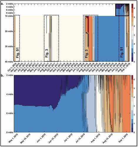
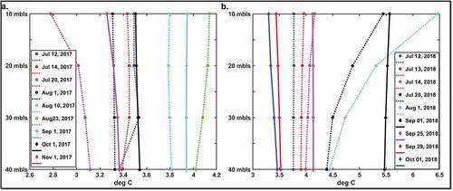
Figure 3. Average daily water temperature and its variation with depths at selected dates during (a) 2017 and (b) 2018 (cf. also ). Profiles during winter stratification, warming, spring overturning, and summer stratification are denoted with stippled lines. Profiles during cooling and arrival at the following years’ winter stratification are denoted with solid lines. Values between depths where water temperature has been acquired (indicated by the lables on the y-axes) are interpolated.
For 2016, the transition from summer stratification (as observed in late September) into fall overturning (completed by 2 October), and further cooling is shown in Figure S1a. For 2019, the transition from winter stratification (exhibiting a strong temperature gradient in the near-surface water masses not sampled prior to 2019) into warming and the onset of spring overturning in early August are shown in Figure S1b. Spring overturning was completed by 20 August, after which summer stratification developed.
Synopsis of lake water temperatures, and weather conditions
A combined view of air temperature, wind speed, solar irradiance (variables available from TRS-AWS), and lake water temperature is shown in (for the periods 1 July–15 November in 2017 and 2018, respectively) and Figure S2 (for the periods 15 September–15 November 2016 and 1 June–5 September 2019).
Figure 4. Synopsis of weather conditions recorded at TRS and lake water temperatures for the period 1 July–15 November 2017 (panels (a1)–(a4)) and 2018 (panels (b1)–(b4)). Vertical colored (stippled and solid) lines mark dates for which selected temperature profiles are presented in . Panel 1: Air temperatures. Panel 2: Wind speed. Panel 3: Solar irradiance. Black solid lines in Panels 1, 2, and 3 denote 12-hour moving averages. Panel 4: Lake water temperature. (a4) and (b4): Water temperature at 10 mbls (green dots, 2-hour resolution; light green line, 12-hour moving average), 20 mbls (turquoise line, 12-hour moving average), 30 mbls (light blue line, 12-hour moving average), and 40 mbls (dark blue line, 12-hour moving average).
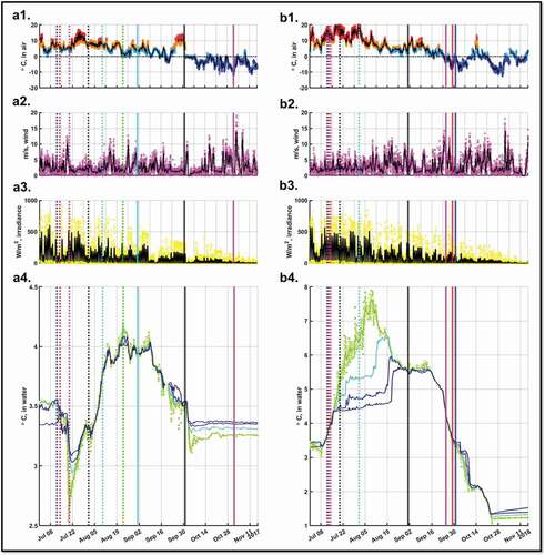
From and and Figures S2 and S1, it is observed that an initial increase in lake water temperatures in 2017 (between 20 July and 1 August), 2018 (between 14 and 20 July), and 2019 (between 1 July and 1 August) coincided with periods of overall high air temperatures and irradiance and low wind speed. Subsequent increases in lake water temperatures were also observed for other combinations, such as moderately high (or even low) air temperature, irradiance, and wind speed (e.g., 10–23 August 2017, 20 July–1 August 2018, 5–10 August 2019). An overall initial decrease in lake water temperatures coincided with periods of decreasing air temperatures and irradiance (e.g., 25 September–1 October 2016, 1 September–1 October 2017, 1–25 September 2018). Wind speeds during these periods were generally variable and moderate. However, on shorter timescales, decreasing lake water temperatures coincided with high wind speed (e.g., 1–2 October 2016, 14–20 July 2017, 23 August–1 September 2017), and with first drops of air temperature to subzero values, irrespective of whether moderate (25–29 September 2018) or low (around 4–5 October 2016) wind speeds prevailed.
Discussion
Vertical mixing dynamics
The thermal regime of Lake Tarfala and the timing and duration of its mixing processes during the ice-free summer months have not yet been studied extensively. Based on the three-year lake water temperature record presented here, it is argued that Lake Tarfala is dimictic and that mixing throughout the entire water column occurs in the spring and in the fall. Practical constraints related to the deployment and recovery of the temperature sensors imply that the first mixing captured in the lake water temperature record was the fall overturning in 2016, followed by both spring and fall overturning in 2017 and 2018 and the spring overturning 2019. Although only two complete annual cycles (based on full years) are available at present, we expect to find evidence for the fall overturning 2019 (and also for spring overturning 2020) once data acquired since 5 September 2019 at site M1 are retrieved and analyzed.
Spring and fall overturning are separated by a period where summer stratification to certain water depths may or may not develop. Because measurements of the lake water temperatures in the uppermost 10 m of the water column at site M1 started only at the end of April 2019, little detail concerning possible stratification in the near-surface water layers can be inferred for September 2016 to April 2019. As seen from Figure S1b, it is essential to acquire temperatures at water depth less than 10 m if stratification is to be captured (Figures S1a and 3) without ambiguities. For 2018, summer stratification at 10 mbls and below is evidenced in . Support for continued stratification into the uppermost water layers (less than 10 mbls) is obtained from temperatures acquired at 3 mbls at the shallow site L1 (), which peaked at 6.7°C on 8 September 2018 as compared to 5.7°C recorded at 10 mbls at M1 on the same day (data not shown). By 25 September 2018, summer stratification had ceased and approached winter stratification for which water temperatures, in the deep as well as the shallow part of Lake Tarfala, attained almost the same values (see , Table S1). Because data from L1 also provide evidence for summer stratification in the uppermost water layers during 2019 (confirming measurements at M1 at, e.g., 4 mbls; see Table S1), it is suggested that measurements at L1 during 2018 support the interpretation that Lake Tarfala was stratified throughout the entire water column during the summer of 2018. During 2017, water masses at depths greater than 10 mbls were weakly stratified, but whether or not the stratification was more pronounced in the uppermost layers cannot be concluded with certainty, because no data are available. Further detail regarding summer stratification in 2019 is expected once the data from M1, acquired since 5 September 2019, are retrieved and analyzed. For 2019 and onward, combination of the lake water temperature data with wind speed data may even give insights into likely patterns and processes of stratification in water depths less than 2 m (for which no measurements are available).
Fall and spring overturning are separated by the winter stratification, during which lake water temperatures at 10 mbls and deeper are at ~3.5°C (2016/2017, 2017/2018) and at ~1.5°C (2018/2019; cf. ), thus showing pronounced interannual variability (see section Lake thermal state: Interannual variability).
Attribution of external environmental conditions to mixing dynamics in Lake Tarfala
Changes in water temperature in lakes are responsible for changes in density and hence intimately related to mixing processes. Changes in water temperature are primarily driven by processes at and across the lake surface, such as the reflection and absorption of solar radiation and wind action. Absorption of solar energy, dissipated as heat in the lakes’ uppermost water layers, generally varies with geographic position, altitude, and season. It is also affected by, for example, optical properties of the lake water, such as turbidity, viz. a reduction in transparency caused by the presence of suspended particles and/or their advection by inflow from other sources in the lake catchment area. Further, absorption of solar energy is affected by local meteorological and atmospheric conditions, causing wind-induced waviness of the lake surface; scattering of the ambient solar radiation by, for example, clouds; and wind-induced redistribution of heat in the uppermost water layers. Finally, it is also greatly affected by the presence or absence of an ice and snow cover, notably impacting surface albedo. Note that transfer of heat from the air to the lake water across the lake surface is usually small in comparison to the heat received from absorbed solar energy. In shallow, clear lakes, incoming solar energy may reach the lake bottom, where it may be reflected by sediments and subsequently dissipated as heat into the water body (Imberger and Patterson Citation1990; Wetzel Citation2001).
At Lake Tarfala, none of these primary controlling factors are measured, rendering attribution of external environmental conditions to vertical lake mixing dynamics challenging. Air temperature, wind speed, solar irradiance, and liquid precipitation are measured at TRS, located ~1 km southeast of the lake, but need not always be representative of the local conditions at the lake. Crucially, neither the timing of ice-on and ice-off nor the thickness of snow cover on the frozen lake has been monitored in the past, implying that the ratio of incoming to reflected energy per unit area as a function of lake ice cover over time cannot even be crudely estimated. In the future, outputs from a recently installed time-lapse camera, as well as from novel combinations of remote sensing products (Miles et al. Citation2017; Barbieux, Charitsi, and Bertrand Citation2018), may offer a partial remedy but are yet unexplored for Lake Tarfala.
Lake thermal state: Interannual variability
With attribution of external factors to vertical mixing processes remaining a challenge, identification of causes for observed interannual variability in timing, duration, and intensity of thermal summer and winter regimes can necessarily be of speculative nature only.
Summer thermal regimes varied over the years (): In 2017, Lake Tarfala experienced only a brief period of elevated lake water temperatures at the end of August, and fall overturning was completed by early September, although air temperatures remained positive (with a few exceptions) until early October. In 2018, the warm summer state lasted from mid-July to mid-September, and fall overturning was completed by the end of September when also a shift to sustained negative air temperatures was observed ( and ). Similar to 2017, Lake Tarfala experienced a warm summer thermal regime at the end of August 2019. However, its duration remains elusive because no water temperatures are available yet after 5 September 2019. Initial warming has been put forward by Iestyn Woolway and Merchant (Citation2017) as a major factor determining the warming of surface waters of cold lakes. In addition, the relation between water temperatures at 10 mbls (and below) and combinations of air temperature, wind speed, and irradiance seems to be sensitive to timing, as exemplified here for July months when lake temperatures were still at their low winter values: During July 2017, when an initial lake cooling was observed at the end of the winter stratification, irradiance and air temperature were moderate to low, whereas wind speeds were moderate to high (). In contrast, during July 2018 and 2019, air temperature and irradiance were moderate to high (likely favoring an early ice-off and associated increased absorption of energy), and wind speeds were low ( and S2b). Indeed, with an average air temperature of 12.8°C, July 2018 was the hottest July on record since measurements at TRS began in 1946 (cf. Methods for references to TRS data sets and July average temperatures of 7.4°C and 9°C in 2017 and 2019, respectively).
Winter thermal regimes varied, too. The lowest winter lake temperatures (~1.3°C) in the three-year time series were attained during winter 2018/2019, following the warm and long summer state and fall mixing late in the season (). It is speculated that these observations can partly be explained by considering glacial meltwater and its potential role in cooling the lake. It is remarked that comparably low winter (1966/1967) lake water temperatures were observed in April 1967 by Björklund (Citation1967) but that a comparison with the 2018/2019 winter state remains speculative because of a scarcity of relevant external environmental data for both periods. Available data comprise average June–July–August air temperatures from TRS (7.4°C in 2018 and 5.7°C in 1966) and the surface mass balance record from Storglaciären (−1,600 mm water equivalent [w.e.] for the mass balance year 1 September 2017–31 August 2018 and −550 mm w.e. for the mass balance year 1 September 1965–31 August 1966; Holmlund, Karlén, and Grudd Citation1996; World Glacier Monitoring Service Citation2020). Both support the notion that cold winter thermal regimes may be related to elevated influx of glacial meltwater into Lake Tarfala during the late summer and fall, under the assumption that similar mass balances held for the glaciers draining into Lake Tarfala. Further, observations from a set of twelve large glacier-fed lakes in Alaska for which temperatures were 3°C lower than in clear lakes not fed by glaciers (Edmundson and Mazumder Citation2002) highlight the role that glacial meltwater may play for lake water temperatures. The variability in temperature and turbidity of glacier meltwaters on seasonal and diurnal timescales may moreover result in complex patterns of underflow, interflow, and overflow in glacier-fed lakes (Chanudet and Filella Citation2008; Peter and Sommaruga Citation2017). After ice-on, snow cover and light absorption would continue to impact winter lake water temperatures, but processes and impacts remain elusive in the absence of direct measurements.
When Lake Tarfala approached its warmer winter states in 2016/2017 and 2017/2018, mass balances at Storglaciären were slightly negative (−240 mm w.e. for the balance year ending 31 August 2016) and even positive (+470 mm w.e. for the balance year ending 31 August 2017). Reduced amounts of glacial meltwater inflow during 2017 may partly explain why lake mixing and summer stratification differ in 2017 and 2018, following the reasoning put forward by Slemmons, Saros, and Simon (Citation2013) that glacier meltwater can affect a lake by altering not only temperature but also physical processes related to hydrology, turbidity, water clarity, and stratification.
During an exceptionally warm summer (such as 2018), a flux of cold water into Lake Tarfala, originating from the surrounding glaciers (), could have enhanced lake mixing. Sediments transported with meltwater could have stirred the water column as they sank toward the lake bottom. According to Cohen (Citation2003), meltwater that is discharging directly from melting glaciers into lakes (ice-contact situations) frequently has suspended sediment concentrations sufficiently high to produce hyperpycnic underflows when entering a lake. In contrast, longer transport distances may cause much of the suspended sediment to settle out prior to its entry into a (pro)glacial lake, producing less concentrated homopycnic interflows or hypopycnic overflows at the lake edge.
Unfortunately, direct measurements of water fluxes into Lake Tarfala are not available. Indirect evidence is available from Tarfala Bridge, ~6 km downvalley of TRS. There, water level is continuously measured, providing a collective signal reflecting outflow of Lake Tarfala, rain, and melt of snow and ice from Storglaciären. During September 2018, high water levels at Tarfala Bridge were recorded even during periods with little precipitation, suggesting sustained ablation at Storglaciären, also supported by an observed lowering of its surface height (SITES data portal Citation2020). Assuming similar ablation patterns for neighboring glaciers, Lake Tarfala has likely received a sustained meltwater influx from Kebnepakteglaciären and Sydöstra Kaskasatjåkkaglaciären during September 2018 when the lake mixing process was ongoing.
Although glacial meltwater may influence stratification patterns, it remains unclear whether this impact is large enough to elicit nonlocal changes in lake thermal structure. Edmundson et al. (Citation1997), for example, examined the thermal stratification in a glacier-fed Alaskan lake and found that water temperatures at 1 mbls were ~1.0°C colder near the point of glacial input compared to further out in the lake. Yet, temperature at larger depth did not show this sensitivity. Further studies, focusing also on precipitation events over glacier surfaces (Peter and Sommaruga Citation2017), are needed to assess the role of glacial meltwater in deforming the mixing patterns and thermal structure of Lake Tarfala.
Conclusions
The first continuous water temperature record from the deepest part of Lake Tarfala is presented, covering the period between September 2016 and September 2019.
Lake Tarfala is characterized as a dimictic lake, where mixing throughout the entire water column takes place twice a year, during spring overturning and fall overturning.
Evidence is emerging that pronounced summer stratification and the location of the metalimnion are confined to the near-surface water layers (2–10 m water depth). Timing, duration, and intensity of summer stratification vary from year to year.
Winter lake water temperatures arrive at steady values during winter stratification but differ between years. The coldest winter lake water temperatures were attained in late 2018 (when a large negative glacier mass balance at Storglaciären was also observed) and after an unusually warm summer thermal state that prevailed for approximately two months and a fall overturning that took place late in the season.
Attribution of external environmental factors to timing and duration of mixing dynamics and thermal states between overturnings is challenging because important variables are not (yet) monitored in situ.
Explanations for observed interannual variability in water temperatures at Lake Tarfala remain speculative. However, glacial meltwater may play a decisive role because larger amounts may enter the lake during exceptionally warm summers (compared to less warm ones) and may therefore also affect mixing processes and have an impact on the winter lake water temperatures attained during winter stratification.
Author contributions
NK, JK, and GR designed the original study and conducted fieldwork in the initial phase of the project. AG and MH continued the fieldwork. NK, AG, KW, JW, FS, and AK designed the continuation of the measuring campaign in Lake Tarfala focusing on the near-surface water layer. NK analyzed all data sets, supported by PE for the TRS-AWS data analysis. NK drafted the article. All authors contributed to the interpretation of the data and results and the writing of the article.
Data availability
The lake water temperature data are available from the Bolin Centre Database at https://doi.org/10.17043/kirchner-2020 and via the SITES data portal at data.fieldsites.se/portal.
Supplemental Material
Download Zip (2.1 MB)Acknowledgments
We thank T. Bergelv, T. Bergström, P. Hancke, T. Karlin, E. Kirchner, L. Kirchner, and E. Strandell Erstorp for support in the field. We are grateful to the editor and two reviewers (Jeffery Stone and anonymous) whose valuable constructive feedback helped improve the article considerably.
Disclosure statement
No potential conflict of interest was reported by the authors.
Supplementary material
Supplemental material for this article can be accessed on the publisher’s website.
Additional information
Funding
References
- Anderson, N. J., O. Bennike, K. Christoffersen, E. Jeppesen, S. Markager, G. Miller, and I. Renberg. 1999. Limnological and palaeolimnological studies of lakes in south-western Greenland. Geology of Greenland Survey Bulletin 183:68–74. doi:https://doi.org/10.34194/ggub.v183.5207.
- Barbieux, K., A. Charitsi, and M. Bertrand. 2018. Icy lakes extraction and water-ice classification using Landsat 8 OLI multispectral data. International Journal of Remote Sensing 39 (11):3646–78. doi:https://doi.org/10.1080/01431161.2018.1447165.
- Benson, B. J., J. J. Magnuson, O. P. Jensen, V. M. Card, G. Hodgkins, J. Korhonen, D. M. Livingstone, K. M. Stewart, G. A. Weyhenmeyer, and N. G. Granin. 2012. Extreme events, trends, and variability in Northern Hemisphere lake-ice phenology (1855–2005). Climatic Change 112 (2):299–323. doi:https://doi.org/10.1007/s10584-011-0212-8.
- Björklund, G. 1967. Temperaturmätningar i Tarfalasjön och dess sedimentbotten [Temperature measurements in Lake Tarfala, and in its sedimentary bottom]. Proseminaruppsats [Proseminar Report], Stockholms universitet, Geografiska institutionen.
- Boehrer, B., and M. Schultze. 2008. Stratification of lakes. Reviews of Geophysics 46 (2):RG2005. doi:https://doi.org/10.1029/2006RG000210.
- Catalan, J., S. Pla-Rabés, A. P. Wolfe, J. P. Smol, K. P. Rühland, N. J. Anderson, J. Kopáček, E. Stuchlík, R. Schmidt, K. A. Koinig, et al. 2013. Global change revealed by palaeolimnological records from remote (high or far) lakes: A review. Journal of Paleolimnology 49 (3):513–35. doi:https://doi.org/10.1007/s10933-013-9681-2.
- Chanudet, V., and V. Filella. 2008. Size and composition of inorganic colloids in a peri-alpine, glacial flour-rich lake. Geochimica et Cosmochimica Acta 72 (5):1466–79. doi:https://doi.org/10.1016/j.gca.2008.01.002.
- Cohen, A. S. 2003. Paleolimnology: The history and evolution of Lake Systems, 499. Oxford: Oxford University Press.
- Dibike, Y., T. Prowse, T. Saloranta, and R. Ahmed. 2011. Response of Northern Hemisphere lake-ice cover and lake-water thermal structure patterns to a changing climate. Hydrological Processes. doi:https://doi.org/10.1002/hyp.8068.
- Edmundson, J. A., and A. Mazumder. 2002. Regional and hierarchical perspectives of thermal regimes in subarctic, Alaskan lakes. Freshwater Biology 47 (1):1–17. doi:https://doi.org/10.1046/j.1365-2427.2002.00775.x.
- Edmundson, J. A., G. B. Kyle, S. R. Carlson, and P. A. Shields. 1997. Trophic–level responses to nutrient treatment of meromictic and glacially influenced Coghill Lake. Alaska Fisheries Research Bulletin 4:136–53.
- Grudd, H., and T. Schneider. 1996. Air temperature at Tarfala Research Station 1946–1995. Geografiska Annaler: Series A, Physical Geography 78 (2–3):115–20.
- Hock, R., G. Rasul, C. Adler, B. Cáceres, S. Gruber, Y. Hirabayashi, M. Jackson, A. Kääb, S. Kang, S. Kutuzov, et al. 2019. High mountain areas. In IPCC special report on the ocean and cryosphere in a changing climate, ed. H.-O. Poörtner, D. C. Roberts, V. Masson-Delmotte, P. Zhai, M. Tignor, E. Poloczanska, K. Mintenbeck, A. Alegriía, M. Nicolai, A. Okem, et al. In press.
- Holmlund, P., and P. Jansson. 1999. The Tarfala mass balance programme. Geografiska Annaler: Series A, Physical Geography 81 (4):621–31. doi:https://doi.org/10.1111/j.0435-3676.1999.00090.x.
- Holmlund, P., W. Karlén, and H. Grudd. 1996. Fifty years of mass balance and glacier front observations at the Tarfala Research Station. Geografiska Annaler: Series A, Physical Geography 78 (2–3):105–14. doi:https://doi.org/10.1080/04353676.1996.11880456.
- Hutchinson, G. E. 1957. A treatise on limnology. Geography, Physics and Chemistry,Vol. 1, xiv + 1015. New York: Wiley.
- Hutter, K., Y. Wang, and I. P. Chubarenko. 2011. Physics of Lakes. Volume 1: Foundation of the mathematical and physical background. New York: Springer.
- Iestyn Woolway, R., and C. J. Merchant. 2017. Amplified surface temperature response of cold, deep lakes to inter-annual air temperature variability. Scientific Reports 7 (1):4130. doi:https://doi.org/10.1038/s41598-017-04058-0.
- Imberger, J., and J. C. Patterson. 1990. Advances in applied mechanics (27). New York: Academic Press.
- Intergovernmental Panel on Climate Change. 2018. Summary for Policymakers. In Global warming of 1.5°C. An IPCC special report on the impacts of global warming of 1.5°C above pre-industrial levels and related global greenhouse gas emission pathways, in the context of strengthening the global response to the threat of climate change, sustainable development, and efforts to eradicate poverty, ed. V. Masson-Delmotte, P. Zhai, H.-O. Pörtner, D. Roberts, J. Skea, P. R. Shukla, A. Pirani, W. Moufouma-Okia, C. Péan, R. Pidcock, et al., 32. Geneva, Switzerland: World Meteorological Organization.
- Intergovernmental Panel on Climate Change. 2019. IPCC special report on the ocean and cryosphere in a changing climate. In Summary for policymakers, ed. H.-O. Poörtner, D. C. Roberts, V. Masson-Delmotte, P. Zhai, M. Tignor, E. Poloczanska, K. Mintenbeck, A. Alegriía, M. Nicolai, A. Okem, et al. In press.
- Jansen, J., B. F. Thornton, M. M. Jammet, M. Wik, A. Cortés, T. Friborg, S. MacIntyre, and P. M. Crill. 2019. Climate-sensitive controls on large spring emissions of CH4 and CO2 from Northern Lakes. JGR Biogeoscience 124 (7):2379–99.
- Kirchner, N., R. Noormets, J. Kuttenkeuler, E. Strandell Erstorp, E. Schytt Holmlund, G. Rosqvist, P. Holmlund, M. Wennbom, and T. Karlin. 2019. High-resolution bathymetric mapping reveals subaqueous glacial landforms in the Arctic alpine lake Tarfala, Sweden. Journal of Quaternary Science 34 (6):452–62. doi:https://doi.org/10.1002/jqs.3112.
- Lantmäteriet. 2015. Digital media. GSD 2+ elevation data. Lantmäteriet, lantmateriet.se.
- Larje, R., and L. Nyberger. 1960. Kartering av bottentopografien I Tarfalasjön (Mapping of bottom topography in Lake Tarfala). Naturgeografiska proseminariet, Stockholms Högskola.
- Lehnherr, I., V. L. St. Louis, M. Sharp, A. S. Gardner, J. P. Smol, S. L. Schiff, D. C. G. Muir, C. A. Mortimer, N. Michelutti, C. Tarnocai, et al. 2018. The world’s largest High Arctic lake responds rapidly to climate warming. Nature Communications 9 (1):1290. doi:https://doi.org/10.1038/s41467-018-03685-z.
- Livingstone, D. M., and A. F. Lotter. 1998. The relationship between air and water temperatures in lakes of the Swiss Plateau: A case study with palæolimnological implications. Journal of Paleolimnology 19 (2):181–98. doi:https://doi.org/10.1023/A:1007904817619.
- Lundin, E. J., J. Klaminder, D. Bastviken, C. Olid, S. V. Hansson, and J. Karlsson. 2015. Large difference in carbon emission: Burial balances between boreal and arctic lakes. Scientific Reports 14248. doi:https://doi.org/10.1038/srep14248.
- Massa, C., B. B. Perren, E. Gauthier, V. Bichet, C. Petit, and R. Hervé. 2012. A multiproxy evaluation of Holocene environmental changefrom Lake Igaliku, South Greenland. Journal of Paleolimnology 48 (1):241–58. doi:https://doi.org/10.1007/s10933-012-9594-5.
- Matlab. 2019. Version 9.6.0.1072779 (R2019a). Natick: The MathWorks Inc.
- Miles, K. E., I. C. Willis, C. L. Benedek, A. G. Williamson, and M. Tedesco. 2017. Toward monitoring surface and subsurface lakes on the Greenland Ice Sheet using Sentinel-1 SAR and Landsat-8 OLI Imagery. Frontiers in Earth Science 5:58. doi:https://doi.org/10.3389/feart.2017.00058.
- Peter, H., and R. Sommaruga. 2017. Alpine glacier-fed turbid lakes are discontinuous cold polymictic rather than dimictic. Inland Waters 7 (1):45–54. doi:https://doi.org/10.1080/20442041.2017.1294346.
- Prowse, T., K. Alfredsen, S. Beltaos, B. Bonsal, C. Duguay, A. Korhola, J. McNamara, R. Pienitz, W. Vincent, V. Vuglinsky, et al. 2011. Past and future changes in Arctic lake and river ice. Ambio 40 (S1):53–62. doi:https://doi.org/10.1007/s13280-011-0216-7.
- R Core Team. 2020. R: A language and environment for statistical computing. Vienna, Austria: R Foundation for Statistical Computing. https://www.R-project.org/.
- Rosqvist, G. C., M. J. Leng, T. Goslar, H. J. Sloane, C. Bigler, L. Cunningham, A. Dadal, J. Bergman, A. Berntsson, C. Jonsson, et al. 2013. Shifts in precipitation during the last millennium in northern Scandinavia from lacustrine isotope records. Quaternary Science Reviews 66:22–34. doi:https://doi.org/10.1016/j.quascirev.2012.10.030.
- Sharma, S., K. Blagrave, J. M. Magnuson, C. M. O’Reilly, S. Oliver, R. D. Batt, M. R. Magee, D. Straile, G. A. Weyhenmeyer, L. Winslow, et al. 2019. Widespread loss of lake ice around the Northern Hemisphere in a warming world. Nature Climate Change 9 (3):227–31. doi:https://doi.org/10.1038/s41558-018-0393-5.
- SITES data portal. 2020. Meteorological data from Tarfala Research Station, 01-01–2019–12-31-2019. https://hdl.handle.net/11676.1/1DheskXcULPJ2ZaQsN1FVS57,andhttps://data-fieldsites.se/portal.
- Slemmons, K. E. H., J. E. Saros, and K. Simon. 2013. The influence of glacial meltwater on alpine aquatic ecosystems: A review. Environmental Science: Processes and Impacts. doi:https://doi.org/10.1039/c3em00243h.
- Šmejkalová, T., M. E. Edwards, and J. Dash. 2016. Arctic lakes show strong decadal trend in earlier spring ice-off. Scientific Reports 6 (1). doi:https://doi.org/10.1038/srep3844.
- Smol, J. P., A. P. Wolfe, H. J. B. Birks, M. S. V. Douglas, V. J. Jones, A. Korhola, R. Pienitz, K. Rühland, S. Sorvari, D. Antoniades, et al. 2005. Climate-driven regime shifts in the biological communities of arctic lakes. Proceedings of the National Academy of Sciences of the United States of America 102 (12):4397–402. doi:https://doi.org/10.1073/pnas.0500245102.
- Weckström, K., J. Weckström, K. Huber, C. Kamenik, R. Schmidt, W. Salvenmoser, M. Rieradevall, T. Weisse, R. Psenner, and R. Kurmayer. 2016. Impacts of climate warming on Alpine lake biota over the past decade. Arctic, Antarctic, and Alpine Research 48 (2):361–76. doi:https://doi.org/10.1657/AAAR0015-058.
- Wetzel, R. G. 2001. Limnology. Lake and river ecosystems. 3rd ed. New York: Academic Press.
- World Glacier Monitoring Service. 2020. Global Glacier change bulletin no. 3 (2016–2017). In ed. M. Zemp, I. Gärtner-Roer, S. U. Nussbaumer, J. Bannwart, P. Rastner, F. Paul, and M. Hoelzle, 274. Zurich, Switzerland: ISC(WDS)/IUGG(IACS)/UNEP/UNESCO/WMO, World Glacier Monitoring Service. Publication based on database version. doi:https://doi.org/10.5904/wgms-fog-2019-12.
- Wrona, F. J., J. Reist, and 27 Contributing Authors. 2013. Freshwater ecosystems. In Arctic biodiversity assessment. Status and trends in Arctic Biodiversity, ed. H. Meltofte. Akureyri: Conservation of Arctic Flora and Fauna. Digitally available from https://oaarchive.arctic-council.org/handle/11374/223.