
ABSTRACT
Northern lakes provide many ecosystem services, including the provision of traditional foods and clean water. These systems are vulnerable to climate-driven changes in hydrology and contaminant accumulation, but the direction and magnitude of projected changes are poorly constrained. One contaminant of concern is mercury; currently, we cannot accurately predict how mercury accumulation in lakes will respond to climate-induced changes, especially in lakes with glacial inflows and complex hydrology. Sediment cores collected from two regions of a glacially fed lake (Lhù’ààn Mân’; Kluane Lake, Yukon, Canada) were analyzed to investigate controls on sediment mercury accumulation in the context of previously described hydrological changes. Differences in catchment contributions drove differences in sediment mercury accumulation between lake regions during the Duke River hydrological period (ca. 750–1650). During the more recent Slims River hydrological period (ca. 1650–2015), mercury accumulation did not differ between regions, and mercury was delivered to the lake primarily via catchment organic matter and carbonate-rich sediments from the largest, glacially derived inflow (Slims River). Recent climate-induced geomorphic change caused loss of the main lake inflow (Slims River) in 2016, making Kluane Lake an ideal system for future investigations of how loss of glacial inflow will affect mercury accumulation in northern lakes.
Introduction
Mercury (Hg) loading to lakes, including remote lakes in the Arctic and subarctic, has increased since industrialization (Schuster et al. Citation2002; Arctic Monitoring and Assessment Programme Citation2011), and Hg concentrations in northern aquatic biota have also generally increased in recent decades (Lockhart et al. Citation2005; Carrie et al. Citation2010). Increases in concentrations of methylmercury (MeHg), a toxic, organic form of Hg, are of particular concern because MeHg bioaccumulates and biomagnifies through aquatic food webs and may reach levels in organisms, including fish, that pose risks to human health (see Mergler et al. Citation2007). This is of concern for northern communities, health care practitioners, and food safety regulators, because northerners rely more heavily on wild-caught fish as a source of food than communities in southern, urbanized regions (Receveur et al. Citation1998; Pirkle, Muckle, and Lemire Citation2016). Given the importance of subsistence fish and fisheries to northerners, it is imperative that we improve our ability to understand and predict effects of environmental change on Hg bioaccumulation in northern lakes (see Ficke, Myrick, and Hansen Citation2007).
The biogeochemical cycle of Hg in freshwater ecosystems is complex. The amount of MeHg available to bioaccumulate in food webs depends on the amount of Hg (both inorganic and MeHg) loaded to the lake ecosystem and on the processes that regulate rates of Hg methylation and demethylation (see Chételat et al. Citation2015; Paranjape and Hall Citation2017; Branfireun et al. Citation2020). Loading of Hg to lakes is affected by weathering rates, relative size and slope of the surrounding catchment (e.g., Drevnick et al. Citation2016), catchment soil composition (e.g., Luo et al. Citation2015), coverage and connectivity of wetlands (particularly peatlands) within the catchment (e.g., Rydberg et al. Citation2010), and atmospheric Hg deposition (e.g., Wiener et al. Citation2006). Allochthonous organic matter often serves as a transport vector for Hg, and increases in organic matter export from catchments can result in increased Hg delivery to lakes (Ouellet et al. Citation2009; Korosi et al. Citation2015; Isidorova et al. Citation2016; Bravo et al. Citation2017; Poste et al. Citation2019), whereas export of eroded minerogenic sediments from catchments can act to dilute Hg loaded to downstream lakes (e.g., Yang and Rose Citation2005; Köck et al. Citation2012; MacDonald et al. Citation2016). Once Hg is delivered to lakes in runoff from catchments and/or from atmospheric deposition, fluxes to bottom sediments are affected by several autochthonous processes, including rates of primary productivity; algal-derived organic matter can bind and concentrate Hg and deliver it to the lake bottom via particle settling (Sanei and Goodarzi Citation2006). Increases in algal production and scavenging of Hg by algal-derived organic matter have been invoked to explain temporal increases in sediment Hg accumulation in several northern lakes (e.g., Stern et al. Citation2009; Carrie et al. Citation2010; Brazeau et al. Citation2013), but these findings are not universal (e.g., Kirk et al. Citation2011; Phillips et al. Citation2011; Cooke et al. Citation2012).
Many of the factors that regulate loading of Hg to lakes and delivery of Hg to lake sediments will be altered by climate change (Rydberg et al. Citation2010; Stern et al. Citation2012). In northern and alpine landscapes, warmer, wetter conditions will likely act to increase exports of organic matter, sediment, and nutrients from catchments to lakes, which will increase fluxes of Hg to lake sediments (Gallagher, Macdonald, and Paton Citation2004; Phillips et al. Citation2011; Stern et al. Citation2012; Creed et al. Citation2018). Melting of glaciers may also release Hg that has accumulated in ice over decades to centuries (Stern et al. Citation2012; Zdanowicz et al. Citation2018) and result in increased loading to lakes. Effects of these changes on bioaccumulation of Hg through the food web are more difficult to predict: though glacial sediments can act as a transport vector for Hg to lakes (Frenet-Robin and Ottmann Citation1978; Plouffe Citation1997; El Bilali et al. Citation2002), strong adsorption onto fine-grained glacial-derived particles can reduce Hg bioavailability and subsequent entry into lake food webs (Zhu and Zhong Citation2015; Sun et al. Citation2016).
An incomplete understanding of how climate-induced changes in hydrology will affect Hg in sediments of northern and alpine lakes precludes generation of models that predict effects on Hg concentrations in biota, including in traditional food fishes. Some knowledge gaps can be filled by investigating how past changes in hydrology affected Hg accumulation in sediments, particularly when variations have been substantial and relatively abrupt. Here, we use paleolimnological methods to investigate Hg accumulation in sediments of Lhù’ààn Mân’ (Kluane Lake), a large, glacially fed lake located in southwestern Yukon Territory, Canada, that has experienced marked, abrupt hydrological changes. Kluane Lake receives inflow from several subcatchments that drain both the St. Elias and Ruby mountain ranges, and the lake is an important source of traditional, subsistence food for Kluane First Nation, Champagne and Aishihik First Nations, and White River First Nation. It is also a destination for sport fishing and recreation. During project development, community members expressed concern that the increased rate of melting of Tänshı̄ (Kaskawulsh Glacier), combined with other effects of climate change, was resulting in increased Hg delivery to Kluane Lake, which could affect levels of Hg in fish. Motivated by these community concerns, we conducted a multicore paleolimnological study to (1) assess whether previously characterized hydrological changes (Brahney et al. Citation2008a, Citation2008b) in Kluane Lake affected sediment Hg accumulation rates, (2) investigate drivers of variability in sediment Hg concentration and accumulation rates, and (3) investigate differences between two lake regions in sediment Hg. Our investigation into effects of hydrological change on Hg accumulation in this system is timely, because the lake has recently undergone another major hydrological change (Shugar et al. Citation2017). The main inflow (A’̈y Chù; Slims River), which delivered glacial meltwaters to the lake, was diverted into an adjacent drainage as a result of glacial recession, and both water quality and quantity in the lake are undergoing marked changes as a consequence.
Materials and methods
Study area
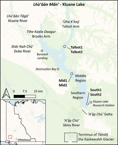
Kluane Lake is a large (area = 408 km2; maximum length = 71.6 km), deep (maximum = ~80 m) lake located in southwestern Yukon Territory (61°17′ N, 138°45′ W; ). The lake has four main regions (). At the time of the study, the inflowing, glacially fed A’̈y Chù (Slims River), located at the southern end of the lake, terminated in a shallow, sediment-rich delta that emptied into the relatively cold, steep-sided, deep southern region (maximum depth = 80, mean surface temperature = 9°C, July 2015; McKnight et al. Citation2021). Ùha K’ènji, the Talbot Arm, comprises the northeastern arm of the lake and is moderately deep (maximum depth = 40 m), as is the Middle Region (maximum depth = 60 m; McKnight et al. Citation2021). Kaala Daagur, the Brooks Arm, which comprises the northwestern arm of the lake, is shallower and warmer (maximum depth = 15 m, mean surface temperature = 15°C, July 2015; McKnight et al. Citation2021; ) and relatively productive. It is from the northwest arm of the lake that Lhù’ààn Tǎgà” (Kluane River) drains (). At the time of this study (April 2015), the largest individual hydrological input to the lake was the Slims River, which conveyed meltwater from the Kaskawulsh Glacier. Numerous other streams originating in the St. Elias and Ruby mountain ranges contribute to the lake over a wide range of scales, both perennially and seasonally (largely driven by annual snowmelt; ).
Figure 1. Map showing sediment core locations (white circles, bold text) and lake regions in Lhù’ààn Mân’ (Kluane Lake; red square, inset map), southwestern Yukon Territory. The communities of Burwash Landing and Destruction Bay and the Kluane Lake Research Station are indicated with gray squares. Other places mentioned in this study are indicated using traditional Southern Tutchone place names and settler English names. Base map data: CARTO Voyager.
Well-documented hydrologic changes to Kluane Lake have occurred several times during the past 2,200 years and resulted in striking changes in water level and locations of inflows and outflows (Brahney et al. Citation2008a, Citation2008b). At ca. BCE 200, water levels in Kluane Lake were approximately 25 m lower than in 2015 CE, and water drained southwards via the Slims River valley into the Kaskawulsh River (Brahney et al. Citation2008a, Citation2008b). By 650 CE, the Duke River () began to flow into Kluane Lake through Brooks Arm, which raised lake levels to approximately 10 to 15 m below 2015 CE levels (Brahney et al. Citation2008a, Citation2008b). During the Little Ice Age (ca. 1200s to 1800s CE; Luckman Citation2000), Kaskawulsh Glacier advanced, reaching its maximum extent ca. 1750 CE (Reyes et al. Citation2006). The advance of the glacier blocked the southern Slims River outflow and routed glacial meltwaters into the lake, which caused lake water levels to rise rapidly, more than 10 m above 2015 CE lake levels (Brahney et al. Citation2008b). This glacial advance was coincident with the loss of Duke River inflow by 1650 CE (Brahney et al. Citation2008a, Citation2008b). High water levels eroded through the Duke River sediment fan at the north end of the lake and formed Kluane River ca. 1690 CE (), which then drained the lake to 2015 CE levels (Clague et al. Citation2006).
In spring 2016 CE, retreat of Kaskawulsh Glacier resulted in diversion of meltwater from the Slims River into the Kaskawulsh River and away from Kluane Lake; this change is likely permanent (Shugar et al. Citation2017). Loss of the majority of glacial meltwater has resulted in record (contemporary) low water levels (Shugar et al. Citation2017) and greatly reduced inputs of both water and sediment to Kluane Lake.
Sediment core collection
Two cores from each of the southern region, middle region, and Talbot Arm of Kluane Lake (; ) were collected in April 2015 using a hammer gravity corer (Glew, Smol, and Last Citation2001) operated through holes drilled through lake ice. After collection, the six cores were transported to the Kluane Lake Research Station, where they were sectioned using a vertical push rod–type extruder (Glew, Smol, and Last Citation2001). Cores from the southern region were sectioned at 1.0-cm intervals, cores from the middle region were sectioned at 0.5-cm intervals, and cores from the Talbot Arm were sectioned at 0.5-cm intervals for the top 25 cm and then at 1.0-cm intervals for the remainder of the core, based on sedimentation rate estimates from previous studies (Brahney et al. Citation2008a, Citation2008b). Samples were placed in Whirlpak bags and stored in the dark at 4°C during shipping and until analysis.
Table 1. Analyses completed in sediment cores collected from the southern arm, the middle region, and the Talbot Arm of Kluane Lake
Sediment core analyses
Oven drying and loss on ignition (LOI) were used to determine water, organic matter, carbonate, and mineral contents of the clay-rich sediments from every core section, following methods described by Smith (Citation2003). Magnetic susceptibility, used as a proxy for terrestrial inputs including eroded soils and bedrock materials (Oldfield et al. Citation1983; Sandgren and Snowball Citation2001), was quantified using a Bartington MS2E high-resolution surface scanning sensor system on wet sediments from every core section. LOI and magnetic susceptibility analyses were conducted at the University of Waterloo Environmental Change Research Lab. Results from LOI and magnetic susceptibility analyses were used to align pairs of sediment cores from each sampling location and to select a core from each pair for further analyses (). For the southern region, core South2 was selected for radiometric dating because the sediment–water interface was lost during the collection of core South1. Both cores (South1, South2) were used for other analyses (). For the middle region, core Mid1 was selected for radiometric dating and core Mid2 was used for all other analyses. For the Talbot Arm, core Talbot2 was selected for radiometric dating and core Talbot1 was used for all other analyses.
Visual reflectance spectroscopy (VRS) was used to infer chlorophyll-a (chl-a) concentrations in lake sediments following methods of Michelutti et al. (Citation2010). Briefly, freeze-dried sediments were homogenized and sieved through 125-μm mesh. Sieved samples were then analyzed using a FOSS NIRS (near-infrared spectrophotometer) model 6500 series rapid content analyzer operating over the range of 400 to 2,500 nm. Chlorophyll-a concentrations were inferred using the percentage reflectance measured between 650 and 700 nm (Wolfe et al. Citation2006). VRS analyses were conducted at the Paleoecological Environmental Assessment and Research Lab at Queen’s University, Kingston, Ontario, Canada.
Total Hg concentrations in sediments were measured using a Milestone DMA-80 (direct mercury analyzer) in accordance with U.S. Environmental Protection Agency method 7473 and ISO 17025 QA/QC at the Biotron Experimental Climate Change Research Center, Western University, London, Ontario, Canada. Approximately 25 mg of freeze-dried, homogenized sediments were used for analysis. After every tenth sample, a duplicate sample was analyzed (mean percentage difference between duplicates ± SD: 3.82 percent ± 4.04 percent, n = 37), as well as a certified reference material (MESS-3: 0.091 ± 0.009 μg g−1 dw; National Research Council of Canada; mean recovery ± SD: 117.93 percent ± 3.79 percent, n = 32). Blanks were analyzed at the start of each run and after every 10 samples (n = 35). Mercury accumulation rates were calculated as the product of sediment dry mass accumulation rates and sediment Hg concentrations.
Sediment dating and age–depth modeling
Activity profiles of 210Pb, 226Ra (as 214Bi and 214Pb together), and 137Cs were determined for sediments from one core collected from each region () at the University of Waterloo Environmental Change Research Lab. Recent chronologies from sediment cores were then developed using the constant rate of supply (CRS) model on 210Pb activity profiles (Appleby Citation2001). Peaks observed in 137Cs activity, corresponding to the 1963 maximum nuclear fallout in the Northern Hemisphere, were used to confirm recent sediment chronologies based on 210Pb analysis (Appleby Citation2001).
Results of 210Pb dating indicated that some cores included time periods older than can be reconstructed by 210Pb methods. Consequently, two wood fragments recovered from Mid2 and Talbot1 were processed for 14C dating. Wood fragments were pretreated using acid–alkali–acid pretreatment (Gupta and Polach Citation1985) at the University of Waterloo Environmental Isotope Laboratory. Treated samples were then combusted and released carbon dioxide was trapped in 6-mm OD Pyrex glass break-seal tubes. Break-seal tubes were analyzed using DirectAMS radiocarbon techniques at Accium Biosciences Accelerator Mass Spectrometry Laboratory, Seattle, Washington. A subsample of carbon dioxide was evolved from each sample for stable carbon isotope analysis (δ13C/ δ12C) to correct 14C ages (Stenström et al. Citation2011). In addition, special attention was paid to a sand-like, white/gray, gritty sediment layer, approximately 4 cm thick, that was observed during sectioning of core Mid1. Subsequent magnetic susceptibility measurements indicated that this layer had distinctly high magnetic susceptibility, greater than ten times sediments in other sections. Following Brahney et al. (Citation2008b), this layer was identified as the White River tephra, a widespread layer of volcanic ash that covered the southwestern Yukon at approximately 803 CE ± sixty years (Clague et al. Citation1995; Bunbury and Gajewski Citation2009). This layer was not observed in any other cores collected but was used to refine the dating model for the middle region.
CRS-modeled sediment chronologies, 14C ages, and the White River tephra age were combined to develop age–depth models for select sediment cores using a Bayesian model implemented within the software package “Bacon” (Blaauw and Christen Citation2011) in R v3.2.5 (R Core Team Citation2016). Briefly, this software package combines data from multiple methods of sediment dating to reconstruct sediment accumulation rates (Blaauw and Christen Citation2011). Radiocarbon ages were calibrated using the IntCal13 calibration curve during age–depth model development (Reimer et al. Citation2013). Default prior distributions were used in model development. Weighted mean ages produced by the Bacon model, dry density (g cm−3; calculated using LOI data), and vertical accumulation rate (cm yr−1) were used to calculate dry mass accumulation rates for each sediment core section.
Preliminary analysis of dry density, magnetic susceptibility, and LOI data indicated the preservation of a seismite-like (Bertrand et al. Citation2008) layer in cores from the middle region and Talbot Arm that we attributed to the 1899 CE Yakutat Bay earthquake event (Lamontagne et al. Citation2008). Another deeper, seismite-like layer was also identified, which was previously characterized as indicating the formation of the Kluane River, between 1680 and 1700 CE, by Clague et al. (Citation2006). These layers were used to iteratively refine “Bacon” age–depth models.
Numerical and statistical analyses
To characterize the influence of past hydrological changes on sediment Hg accumulation in Kluane Lake, distinct hydrological periods were defined a priori following Brahney et al. (Citation2008a, Citation2008b): the Duke River period (ca. 750–1650 CE) and the Slims River period (ca. 1650–2015 CE). Hydrological periods were defined to reflect the time when these rivers were the major sources of water and sediment to Kluane Lake.
To investigate drivers of Hg accumulation in Kluane Lake sediments, mean Hg accumulation rates, dry mass accumulation rates, and sediment Hg concentrations were compared between hydrological periods and core locations using Welch’s unequal variances t tests. If significant differences were found, each region and hydrological period was analyzed separately. Because Hg accumulation rate is calculated as the product of dry mass accumulation rate and Hg concentration, each of these parameters was correlated (using Pearson’s product-moment correlations) with other paleolimnological proxies measured in that core, including organic, mineral, and carbonate content; magnetic susceptibility; and VRS-inferred chl-a. Prior to correlation analysis, statistical outliers were removed from stratigraphic data. Outliers were removed so that longer-term environmental drivers of mercury accumulation could be characterized without the influence of infrequent events (e.g., earthquakes) that do not reflect long-term processes. Outliers were defined as beyond 1.5 * interquartile range ± median.
All statistical analyses were conducted using the software R v3.2.5, with the core package libraries and “Bacon” v2.2 (Blaauw and Christen Citation2011). Figures were generated using R, SigmaPlot v12.0 (Systat Software, San Jose, California, USA), and open-source QGIS Desktop v3.2.0-Bonn. Residuals from correlation analyses and t tests were visually inspected for normality and tested for normality using Shapiro-Wilk tests. Alpha was set at .05.
Results and discussion
Sediment core chronologies
Total 210Pb activity decreased with depth in the sediment core from the southern region (South2), from 3.9 dpm g−1 at the surface to 2.34 dpm g−1 at 10.5 cm depth, before increasing to 2.47 dpm g−1 at 20.5 cm depth (Supplemental Materials). Low radioisotope activities suggested a high sedimentation rate in this core. Stratigraphies of LOI were used to transfer the age–depth relationship from the South2 core to the South1 core, and a linear estimate from the age–depth relationship for South1 produced a core bottom age of approximately 1908 CE at 86.0 cm depth. Based on these results, cores from the southern region did not include the hydrological change that occurred ca. 1650 CE that we intended to investigate and therefore other data from this core were not included in further analyses. Radioisotope activity profiles for core South2 and the estimated age–depth relationship and Hg accumulation rate for core South1 are included in the Supplemental Materials; stratigraphic data for LOI, total Hg concentration, dry mass accumulation rate, and Hg accumulation rate for both cores from the southern region are found in Zabel (Citation2017).
Total 210Pb activity decreased with depth in the sediment core from the middle region (Mid2), from 7.92 dpm g−1 at the surface to 1.64 dpm g−1 at 5 cm depth, before increasing to 2.32 dpm g−1 at 8.0 cm depth ( inset). Measured total 210Pb activity at 3.5 cm depth (1.98 dpm g−1 ± 0.18, 1 SD) was within one standard deviation of the mean estimated supported 210Pb activity (2.10 dpm g−1 ± 0.24, 1 SD), indicating that background was reached. Measured 210Pb activity exceeded background values at 4 cm depth, however, before returning to background at 4.5 cm depth ( inset). The peak activity of 137Cs (1.68 dpm g−1 ± 0.06, 1 SD) was measured at 2.5 cm depth, corresponding with a CRS date of 1963 CE (±7.3 years, 1 SD). The radiocarbon age of the twig was 1,108.43 ± 25.83 14C years BP at 52.0 cm. Using all available data, including radiocarbon ages and the depth of White River tephra, results from the Bacon model produced a core bottom weighted mean age of approximately 826 CE (95 percent confidence interval, 721–909 CE) for the core from the Middle region ().
Figure 2. Age–depth relations for core Mid2 (A, top) and core Talbot1 (B, bottom) from Kluane Lake, developed using Bacon, and radioisotope activity plots (inset). Radiocarbon dates were calibrated using IntCal13 (Reimer et al. Citation2013) and are plotted in blue. CRS model dates and marker layers (including the 1899 CE Yakutat Earthquake and formation of the Kluane River in 1690 CE and the White River tephra layer 803 CE) are plotted in teal. The weighted mean age–depth model is plotted with a red dashed line, the 95 percent confidence intervals are plotted as a gray dotted line, and the Markov chain Monte Carlo iterations for each section age are plotted as a black cloud (darker black represents a higher frequency of occurrence). Ages are plotted as calendar years before present (before 1950 CE). See Blaauw and Christen (Citation2011) for more information on Bacon age–depth modeling.

Total 210Pb activity in the sediment core from the Talbot Arm (Talbot1) increased from the surface (13.50 dpm g−1) to 0.5 cm depth (13.74 dpm g−1) before declining with depth to 2.16 dpm g−1 at 7 cm depth, at which point background was reached ( inset). The peak activity of 137Cs (2.22 dpm g−1 ± 0.06, 1 SD) was measured at 3.0 cm depth ( inset), corresponding with a CRS date of 1963 CE (±16.7 years, 1 SD). The radiocarbon age of the twig was 576.67 ± 25.06 14C years BP at 33.0 cm. Using all available data, including radiocarbon age and standard deviation and CRS ages and standard deviations, results from the Bacon model produced a core bottom weighted mean age of approximately 1009 CE (95 percent confidence interval, 811–1193 CE; ).
Description of sediment stratigraphies
Age–depth models indicated that the cores collected from the middle region and the Talbot Arm span both the Duke River and Slims River hydrological periods (Brahney et al. Citation2008a, Citation2008b, Citation2010). Stratigraphic profiles in cores from both regions indicate that after ca. 1650 CE (), variability in organic and carbonate content, dry density, and Hg concentration increased. The timing of this increase in variability in several paleolimnological proxies corresponds with a transition in hydrological periods, from the Duke River period (750–1650 CE) to the Slims River period (1650–2015 CE; ).
Figure 3. Stratigraphic plots showing temporal variation of measured variables in sediment cores Mid2 (top) and Talbot1 (bottom) collected from the middle region and Talbot Arm of Kluane Lake. Mercury accumulation on Mt. Logan reconstructed from an ice core (locally estimated scatterplot smoothing smoothing) is shown on the right in medium blue (modified from Beal et al. Citation2015). The Duke River period is shown with gray shading; the Slims River period is not shaded. The blue solid line represents the formation of the Kluane River (1690 CE; Clague et al. Citation2006). The orange dashed line represents a major sediment disturbance event in 1899 CE.
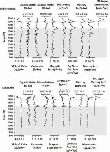
The Duke River period (750–1650 CE)
The Duke River period was characterized by relatively low variability in all variables (750–1650 CE; shaded zone in ). Though somewhat higher in the Talbot Arm than in the middle region, carbonate content decreased gradually in cores from both regions during the Duke River period (), which likely reflects decreasing inputs of carbonate-rich sediments that originated from the Duke River catchment. VRS-inferred chl-a concentrations indicated that primary production was generally higher in the Talbot Arm than in the middle region. Inferred chl-a values increased steadily in the core from the middle region, however, and became similar to those observed in the Talbot Arm core after ca. 1580 CE (). Relatively low variability in both Hg concentration and Hg accumulation in both cores likely also reflects the relatively invariable and low rate of atmospheric Hg deposition that occurred during this period (Beal et al. Citation2015; ), which was prior to the onset of anthropogenically induced increases in atmospheric Hg concentrations (Streets et al. Citation2011).
The Slims River period (1650–2015 CE)
Following the inferred transition from the Duke River period (750–1650 CE) to the Slims River period (unshaded zone in ; 1650–2015 CE), there were marked increases in stratigraphic variability in several paleolimnological variables from both the middle region and Talbot Arm cores (). This variability was likely driven by hydrologic change as well as numerous earthquakes that occurred during the Slims River period (Clague Citation1981; Lamontagne et al. Citation2008). Distinct peaks in carbonate content, mineral content, magnetic susceptibility, dry density, dry mass accumulation rate, Hg concentration, and Hg accumulation rate were observed in both cores ca. 1690, 1900, and 1955 CE (). The largest of the identified peaks occurred ca. 1690 CE (shown as a blue horizontal line in ), when magnetic susceptibility, dry density, dry mass accumulation rate, Hg concentration, and Hg accumulation rate increased in both cores, whereas carbonate content increased in the core from the Talbot Arm only. The inferred timing of this peak is consistent with formation of the Kluane River (1680–1700 CE; Clague et al. Citation2006). Brahney et al. (Citation2008b) observed a similar pattern in density and magnetic susceptibility in their sediment cores at this inferred time.
Despite differences in magnitude, we interpret peaks in several variables in cores at ca. 1900 and 1955 CE as indicative of seismic activity (orange dashed lines, ). Peaks in magnetic susceptibility, Hg concentration, and Hg accumulation rates were observed in both regions at ca. 1900 CE, whereas peaks in carbonate content, dry density, and dry mass accumulation rate were observed only in the middle region (). Doig (Citation1998) attributed a layer of dense, silty sediments in a Kluane Lake sediment core dated to ca. 1900 CE to the 1899 CE Yakutat Bay, Alaska, earthquakes (Lamontagne et al. Citation2008), and our results are consistent with this (horizontal orange dashed line in ). Another seismic event appeared to be reflected in the Talbot Arm core ca. 1955 CE, which is consistent with an earthquake that was recorded adjacent to the Talbot Arm in 1956 CE (Clague Citation1981).
It is possible, although very unlikely, that atmospheric deposition of Hg directly to Talbot Arm could be a driver of the increased Hg concentration and accumulation ca. 1950s CE that was observed in the Talbot Arm core. No similar concurrent peak or increase in Hg concentration or accumulation rate was observed in the middle region (); in fact, Hg concentration and accumulation in the middle region declined between ca. 1900 and 2015 CE. Timing of peak Hg accumulation rates inferred from ice core data collected from the Mt. Logan glacier, located within the nearby Kluane National Park and Reserve, appears to correspond with timing of peak Hg concentration and accumulation rates observed from the sediment core collected from the Talbot Arm (Beal et al. Citation2015; ). The mid-century peak in Hg accumulation on Mt. Logan was attributed to emissions of Hg from industrial aerosols and burning of coal across the Northern Hemisphere, which increased from World War II until approximately the 1970s (Beal et al. Citation2015). Because a peak in Hg concentration and/or accumulation rate was not observed in the core collected from the middle region, however, increased regional atmospheric deposition of Hg seems an unlikely driver of the peaks observed in Hg concentration and accumulation in the core collected from the Talbot Arm. We conclude that seismic activity, which likely triggered sediment resuspension and redeposition, as well as potential inputs of catchment soils through landslides or similar phenomena (Clague Citation1981; Doig Citation1991, Citation1998), drove observed peaks in Hg concentration, Hg accumulation rates, and magnetic susceptibility in the Talbot Arm ca. 1955 CE ().
Spatiotemporal differences in mercury accumulation rates
The Duke River period
During the Duke River hydrologic period, sediments accumulated faster in the Talbot Arm than in the middle region (t113 = 7.97, p < .001), but mean Hg concentration was higher (t59 = 8.491, p < .001) and Hg accumulated faster (t58 = 3.807, p < .001) in the middle region than in the Talbot Arm (). Results from correlation analyses revealed that these differences likely reflect between-site variability in sediment sources; it appears that mineral sediments that were higher in Hg and eroded from the catchment were relatively more important for the middle region, whereas glacially derived sediments that were lower in Hg (likely delivered via Duke River) were relatively more important for the Talbot Arm. Differences in sediment Hg concentration between regions thus appear to reflect variability in the underlying geology and exposed stratigraphy among the different subcatchments of the lake.
Table 2. Mean (SD) Hg concentration, Hg accumulation rate, dry mass accumulation rate, organic content, carbonate content, mineral content, VRS-inferred chl-a concentration, and magnetic susceptibility in cores Mid2 and Talbot1 during the Duke River period and the Slims River period
In the middle region during the Duke River hydrologic period, Hg concentrations were positively correlated with mineral content (), indicating an inorganic or geologic source of Hg, and negatively correlated with carbonate content (), indicating dilution of Hg by fine sediments eroded from the carbonate-rich catchments of the Duke River valley (Yukon Geological Survey Citation2017). Sediment dry mass accumulation rates were positively correlated with magnetic susceptibility (), which suggests that catchment erosion was a dominant source of sediments to the middle region during the Duke River hydrologic period.
Table 3. Significant correlations in cores Mid2 and Talbot1 during the Duke River period and Slims River period between Hg concentration and other paleolimnological variables and between dry mass accumulation rate and other paleolimnological variables
In the Talbot Arm during the Duke River hydrologic period, Hg concentration was not significantly correlated with any measured variables () and therefore inferences about Hg source cannot be made. In contrast to the middle region, where the dominant sediment source appeared to be catchment erosion, dry mass accumulation rate in the Talbot Arm was positively correlated with carbonate content and negatively correlated with mineral content (), indicating that glacial inflow from the Duke River was a dominant source of sediments.
Overall, the data indicate that catchment erosion and glacial river inflows drove sediment accumulation in the middle region and Talbot Arm, respectively, during the Duke River period. Incoming Hg, adsorbed to or contained in sediments derived from weathering and erosion of other catchment geology, was diluted by lower Hg glacial/riverine sediments transported by the Duke River. Because the middle region was further from the Duke River, it likely received proportionally more inputs from catchment weathering and erosion than from glacial river inputs during the Duke River hydrologic period; this is supported by relatively higher magnetic susceptibility and lower carbonate content in the middle region than in Talbot Arm (). Given the positive relationship between Hg concentration and direct contributions from catchment erosion (inferred from mineral content; ) in the middle region, a greater proportion of sediment inputs from catchment sources other than glacial inputs likely explains the higher observed sediment Hg concentrations in the middle region relative to the Talbot Arm (). The Talbot Arm, which was located closer to the Duke River inflow, likely received more glacial river sediments, which acted to dilute incoming Hg, as evidenced by the negative correlation between carbonate content and Hg concentration (). Dilution of trace metals, including Hg, from one sediment source by another has been observed in several lakes by Yang and Rose (Citation2005). Given the results of this study and the findings of Yang and Rose (Citation2005), we infer that sources of Hg to Kluane Lake during the Duke River period were largely nonglacial and inorganic. We further infer that rates of Hg accumulation in Kluane Lake during the Duke River hydrologic period were controlled by the relative importance of sediment contributions from the catchment, which were higher in Hg than sediments derived from glacial erosion, which were lower in Hg, and that differences in sediment contributions explain the spatial differences in Hg between lake regions.
The loss of Duke River inputs and the capture of Slims River inflow into the lake marked the transition from the Duke River hydrologic period to the Slims River hydrologic period and resulted in changes in mean Hg accumulation rate, Hg concentration, and dry mass accumulation rate in both studied regions of Kluane Lake ( and ). In the middle region, sediments accumulated faster during the Duke River period than during the Slims River period (independent samples t test: t114 = −2.124, p = .035; ), but mean Hg accumulation rate and mean Hg concentration did not differ significantly between the hydrologic periods (independent samples t test: t67 = 0.066, p = .947; t66 = 0.709, p = .480, respectively; ). In the Talbot Arm, mean Hg concentration was higher and Hg accumulated faster (independent samples t test: t61 = 4.114, p < .001; t61 = 2.113, p = .038, respectively; ) during the Slims River period relative to the Duke River period, despite no difference in sediment accumulation rate (independent samples t test: t79 = 1.852, p = .067; ). These region-specific differences in sediment accumulation rates and Hg concentrations between hydrological periods suggest a change in sediment and/or Hg source following hydrological reorganization.
The Slims River period
Similar to what was observed during the Duke River hydrologic period, Hg concentration was significantly higher in the middle region than in the Talbot Arm (t69 = 6.013, p < .001; ) during the Slims River hydrologic period. Also similar to the Duke River period, sediments accumulated faster in the Talbot Arm than in the middle region (t78 = −3.756, p < .001; ). Mean Hg accumulation rates, however, did not differ significantly between regions (t78 = −0.650, p = .517; ). Results of correlation analyses suggested that allochthonous organic matter may have been the dominant source of Hg in sediment to both regions ().
In both the Talbot Arm and the middle region, Hg concentration was positively correlated with organic content () during the Slims River period, indicating that organic matter was an important vector for Hg; this was not observed during the Duke River period. Mercury concentration was negatively correlated with VRS-inferred chl-a in the Talbot Arm (), and no significant correlation was found between Hg concentration and VRS-inferred chl-a in the middle region (r = −0.314, p = .255), which suggests that the source of organic matter that served as a vector for Hg was not autochthonous at either location. Given this, we suggest that algal scavenging was not an important mechanism for Hg delivery to sediments in either region during the Slims River period. There was no significant correlation between organic matter content and VRS-inferred chl-a in the middle region (r = −0.352, p = .198), and organic matter content was negatively correlated with VRS-inferred chl-a (r = −0.650, p = .001) in the Talbot Arm, which further supports the inference that the dominant source of organic matter to the lake, and the dominant source of organic matter that delivered Hg to sediments, was allochthonous in origin.
The finding that allochthonous organic matter was a more likely source of Hg to lake sediments than autochthonous organic matter contrasts with results from a previous study on sediment Hg accumulation in Kusawa Lake (Nàkhų Män). Kusawa Lake is also a large, deep, glacially fed lake in southwestern Yukon. Stern et al. (Citation2009) concluded that higher Hg concentrations in recent (post-1950s) sediment core samples were due to increased algal scavenging. In Stern et al. (Citation2009), algal organic matter production was inferred from concentrations of S1 and S2 carbon that were quantified using organic petrographic techniques (Rock-Eval, Vinci Technologies, France). Similarities in stratigraphic profiles between concentrations of Hg and in S1 and S2 carbon led the authors to conclude that algal scavenging was responsible for observed temporal increases in Hg concentration (Stern et al. Citation2009). We found no evidence of increased algal production or algal scavenging of Hg in either the middle region or the Talbot Arm of Kluane Lake using VRS-inferred chl-a. Previous authors have reported varying relationships between Hg concentration and algal production proxies (including inferred chl-a and Rock-Eval analysis) in sediments of arctic and subarctic lakes; results range from no relationship to strong positive relationships (e.g., Kirk et al. Citation2011; Cooke et al. Citation2012; Burke et al. Citation2018; Outridge et al. Citation2019). Conflicting and inconsistent results likely reflect variability among systems in the relative importance of allochthonous and autochthonous organic matter sources, catchment characteristics, relative catchment size, and dominant runoff mechanisms. Discrepancies also highlight the need for further study, including assessments of comparability of different proxies of algal production.
Carbonate content was significantly related to Hg concentrations in sediment in both regions during the Slims River period; however, relationships between carbonate content and sediment Hg concentration were not consistent between regions (). Whereas carbonate-rich sediments appeared to dilute Hg in the Talbot Arm, carbonate-rich sediments appeared to be a source of Hg in the middle region; this likely reflects different sources of carbonates. In the Talbot Arm, negative correlations between Hg concentration and both carbonate content and magnetic susceptibility indicate dilution of Hg by catchment-derived, carbonate-rich sediments (), similar to what was observed during the Duke River period. Hg concentration was also negatively correlated with dry mass accumulation rate, indicating that increased sedimentation rate diluted Hg inputs to this region (). A positive correlation between magnetic susceptibility and carbonate content (Pearson’s r = 0.560, p < .001) suggests that magnetic susceptibility is related to glacial river sediment and/or localized carbonate erosion inputs to this region. Calcareous tills line many of the valleys and creek beds in the Kluane region (Grier and Ballard Citation1981), and we suggest that erosion and transport of these tills by tributaries that are proximate to or drain into the Talbot Arm are likely sources of carbonate-rich sediments to the Talbot Arm; carbonate-rich glacial sediments delivered by the Slims River would have to be transported more than 40 km down the lake before deposition in the Talbot Arm. Given the negative correlations between Hg concentration and each of carbonate content, magnetic susceptibility, and dry mass accumulation rate (), we conclude that erosion and delivery of calcareous tills to the Talbot Arm during the Slims River period diluted Hg transported to this region from allochthonous organic matter sources.
Whereas carbonate-rich sediments originating from the catchment in the Talbot Arm region acted to dilute Hg, carbonate-rich sediments in the middle region appeared to act as a source of Hg to Kluane Lake. Carbonate content of sediments from the middle region was positively correlated with Hg concentration (), indicating a carbonate-rich sediment source of Hg to the middle region. The positive correlation between Hg concentration and dry mass accumulation rate () further indicates that the principal sediment source to the middle region is also the principal source of Hg. Further, the negative correlation between dry mass accumulation and mineral content () indicates that noncarbonate mineral contributions to sediments are minimal. The most likely source of carbonate-rich sediments to the middle region during this hydrological period is A’̈y Chù, the glacially sourced Slims River. Glacial rivers and sediments are often enriched in carbonates (Anderson et al. Citation2000). Glacial rivers and sediments can also be enriched in Hg, because of Hg accumulation on the glacier surface (via atmospheric deposition), followed by release during glacial ablation (Zdanowicz et al. Citation2018).
Higher atmospheric Hg concentrations after the Industrial Revolution likely explain why glacial sediments diluted Hg during the Duke River period but acted as a source of Hg during the Slims River period, despite the fact that glacial meltwater was the primary water source to Kluane Lake during both hydrological periods (). Atmospherically transported Hg, whether anthropogenic or natural in origin, accumulates on the surface of glaciers (Schuster et al. Citation2002), including those within the Duke River catchment and the Kaskawulsh Glacier, which fed Kluane Lake during the Duke River and Slims River periods, respectively (). During the Duke River period, as the glaciers within the Duke River catchment melted, only naturally occurring Hg was released. Ice core data indicate that deposition rates of naturally occurring Hg were relatively constant and low during this period (Beal et al. Citation2015), and we suggest that glacially derived sediments transported by the Duke River diluted Hg inputs from other sources, such as erosion. However, during the Slims River period, both natural and anthropogenic Hg were released and delivered to Kluane Lake via glacial meltwaters. The quantity of Hg delivered during the Duke River period via the Duke River would most likely be lower than that delivered via Slims River during the Slims River period, because the magnitude of global atmospheric Hg flux, and thus deposition to glaciers, has increased significantly since ca. 1850 due to anthropogenic activities (Beal et al. Citation2015). Erosion of the complex bedrock of the Slims River valley, which includes localized lignite coal, mineralized gold, and gypsum deposits, may also have contributed naturally occurring Hg to the Slims River after the hydrologic shift (Rytuba Citation2003; Yudovich and Ketris Citation2005). Natural sources are likely negligible compared to anthropogenically derived Hg delivered by atmospheric deposition to both glaciers and catchment soils, however, from which delivery to downstream Kluane Lake occurs via suspended sediment.
Total Hg concentration in Slims River water was quite low (total [Hg] in unfiltered water: 3.86 ng L−1), and similar to concentrations found in other subarctic and arctic rivers (Søndergaard et al. Citation2015; Vermilyea et al. Citation2017; Zolkos et al. Citation2020). Interestingly, most of the Hg in the Slims River was found in the particulate phase (dissolved [Hg]: <0.05 ng L−1, <1.3 percent of total Hg) and was likely sorbed to fine, glacial, suspended sediments carried by the river (Vermilyea et al. Citation2017) to downstream Kluane Lake. In the southern region, near the Slims River outlet (), sediment Hg accumulation rates were more than ten times higher (mean: 406 µg m−2 yr−1; Figure S2) than in the middle region, Talbot Arm (), and other regional lakes (Drevnick et al. Citation2016, Supplemental Data). The sediment-bound Hg delivered to the south basin of Kluane Lake is/was likely not very bioavailable, because the concentrations of mercury in lake trout (Salvelinus namaycush) and lake whitefish (Coregonus clupeaformis) muscle collected from Kluane Lake are among the lowest in subarctic and Arctic Canada (Zabel et al. Citation2016).
Anthropogenic mobilization and subsequent atmospheric deposition of Hg appears to have been a more important control of Hg delivery to Kluane Lake than hydrological change. Authors of a recent study of Kusawa Lake reached a similar conclusion regarding glacial sources of Hg to downstream lakes. Zdanowicz et al. (Citation2018) concluded that legacy anthropogenic Hg released from glacial ice is the largest current source of Hg to Kusawa Lake, a large, glacially fed lake located approximately 130 km east of Kluane Lake. Kluane (until 2016) and Kusawa lakes are fed by glacial rivers that originate in the same mountain ranges and have similar catchment characteristics. Geographic proximity suggests similar atmospheric Hg delivery to the alpine glaciers that provide(d) meltwater to both lakes and therefore likely a similar importance of glacial meltwater as a primary source of Hg, at least prior to the diversion of the Slims River (Shugar et al. Citation2017). Since the diversion of the Slims River in 2016, sources of water and Hg to Kluane Lake have changed significantly. Further work quantifying current inputs of Hg to Kluane Lake sediments should be undertaken to better understand the proportional contributions of glacial, catchment, and direct atmospheric sources, particularly in light of the recent diversion of the main lake inflow.
Conclusions and implications
In this study, we investigated how past hydrological changes affected sediment Hg accumulation in Lhù’ààn Mân’ (Kluane Lake; ). The transition from the Duke River to the Slims River hydrological period, which was marked by alterations of river inflows and outflows and hydrological reorganization, resulted in increased Hg accumulation in sediments in the Talbot Arm region. These increases were driven by both increased Hg concentration in sediment and increased sediment accumulation rate. Little change in mean Hg accumulation rate was observed in the middle region, and increased variability observed during the Slims River period is inferred to reflect the numerous earthquakes that occurred. Temporal trends in Hg accumulation, Hg concentration, and sediment accumulation differed between regions during the Slims River period, and results suggest that changes in sediment source and composition drove these observed differences. During the Duke River period, catchment erosion of Hg-bearing materials was likely the major source of Hg to Kluane Lake, whereas during the Slims River period, Hg borne on sediments transported by glacial meltwater and on catchment-derived organic matter appeared to be the dominant sources. The interaction between hydrological and environmental change, namely, an increase in anthropogenically sourced Hg that was transported to the catchment by atmospheric deposition, resulted in increased Hg export from both glacial and terrestrial sources.
Rapid warming of Yukon Territory (Streicker Citation2016), combined with the abrupt loss of the cold meltwaters from the Kaskawulsh Glacier in 2016 (Shugar et al. Citation2017), has triggered a new hydrologic period for Kluane Lake. The loss of glacial meltwater is expected to be a relatively permanent hydrological change (Shugar et al. Citation2017). Without meltwaters from the Kaskawulsh Glacier, flows in the Slims River have declined dramatically, as has, presumably, the amount of sediment being transported to the lake. The decline of both sediment and water inputs from Slims River means that Kluane Lake has lost its most significant source of mercury. It remains to be seen how this hydrological change will affect mercury accumulation dynamics in lake sediments and biota, because inputs from other tributaries, some of which are more forested and have lower concentrations of suspended sediments, will now represent proportionally greater inputs of water and Hg to the lake.
Following the findings of Zdanowicz et al. (Citation2018), lake sediment Hg concentrations may decline as legacy Hg inputs that derive from the Kaskawulsh Glacier decline. However, potential increases in autochthonous and/or allochthonous organic matter could result in increased sediment Hg concentrations (Stern et al. Citation2009; Branfireun et al. Citation2020). Warmer lake water, decreased fine sediment deposition, and/or regional warming could foster increased algal production, including phytoplankton and periphyton, and therefore Hg scavenging by autochthonous algal-derived organic matter (Stern et al. Citation2009; Whitehead et al. Citation2009; Chételat et al. Citation2015; Branfireun et al. Citation2020). Regional warming, due to climate change, could also result in increased allochthonous organic matter export through the alteration of organic matter storage and cycling in the terrestrial catchment. Increases in vegetative growth, acceleration of treeline expansion, alterations to vegetative succession, decreases in snowpack, and increases in decomposition rates in soil are expected and could result in increased delivery of allochthonous organic matter and Hg to Kluane Lake (Obrist Citation2007; Stern et al. Citation2009; Isidorova et al. Citation2016; Streicker Citation2016; Branfireun et al. Citation2020).
Changes in water chemistry in Kluane Lake that reflect hydrological change and regional warming may also affect mercury dynamics. Following the abrupt hydrologic shift and loss of glacial meltwaters, lake levels are at record lows (Water Survey of Canada, station 09CA001) and may continue to fall until the lake is a closed or semiclosed basin, a state that has occurred in the past (Brahney et al. Citation2008a, Citation2008b). With greatly decreased inflows and limited outflow, water residence time will presumably increase. Longer water residence time has been associated with lower total Hg concentrations in lake water (Richardson et al. Citation2021), suggesting that hydrologic (semi-)closure could continue to maintain the low lake water Hg concentrations in Kluane Lake. However, changing proportions of water sources could affect the chemistry of the lake and thereby mercury cycling dynamics. Stronger stratification may occur as a result of an increased proportion of dense, sulfate-rich groundwater inputs that originate from numerous upwellings throughout the lake (Harris Citation1990; McKenzie and Wilson Citation2005; Brahney et al. Citation2008a). Density-driven stratification could also result in localized meromictic conditions and subsequent sediment anoxia (Brahney et al. Citation2008a, Citation2008b). The potential combination of anoxic conditions and labile sulfur compounds in the hypolimnion, combined with potential increases in organic matter in the water column, from both the catchment and increased autochthonous primary production, could produce biogeochemical conditions that result in a release of Hg that had accumulated in the sediments over decades (Branfireun et al. Citation2020; Hudelson et al. Citation2020), but ongoing research is required to monitor and test this. Because the hydroecological future of Kluane Lake is uncertain, further study and ongoing monitoring are critical to understanding changes in Hg delivery and relative contributions from potential Hg sources to Kluane Lake in this new hydrological period, as well as the effect on mercury concentrations in aquatic organisms and valued fish species.
Supplemental Material
Download Zip (82.2 KB)Acknowledgments
This research was conducted under the Yukon Territory Scientists and Explorers License number 15-26S&E and took place on the traditional territories of the Kluane First Nation, the White River First Nation, and the Champagne and Aishihik First Nations. We thank N. Kassi and the citizens and administration of Kluane First Nation, especially M. Alatini, M. J. Johnson, G. Pope, and K. van Ballegooyen, for their support and facilitation of this project. We further thank the Dän Keyi Renewable Resource Council, especially P. Sias, for their support of the project. This project was made possible by assistance from L. Goodwin and S. Williams, D. Hik, E. McKnight, J. Turner, R. van Leeuwen, E. MacDonald, and E. Mehler. We sincerely thank Dr. P. E. Drevnick and one anonymous reviewer whose comments helped improve and clarify this article. 210Pb dating was conducted by J. Wiklund, University of Waterloo.
Disclosure statement
No potential conflict of interest was reported by the authors.
Supplementary material
Supplemental material for this article can be accessed on the publisher’s website.
Additional information
Funding
Related Research Data
References
- Anderson, S. P., J. I. Drever, C. D. Frost, and P. Holden. 2000. Chemical weathering in the foreland of a retreating glacier. Geochimica et Cosmochimica Acta 65 (7):1173–89. doi:https://doi.org/10.1016/S0016-7037(99)00358-0.
- Appleby, P. G. 2001. Chronostratigraphic techniques in recent sediments. In Tracking environmental change using lake sediments. Volume 1: Basin analysis, coring and chronological techniques, developments in paleoenvironmental research, ed. W. M. Last and J. P. Smol, 73–105. Dordrecht, The Netherlands: Kluwer Academic Publishers.
- Arctic Monitoring and Assessment Programme (AMAP). 2011. AMAP assessment 2011: Mercury in the Arctic. Oslo, Sweden: AMAP.
- Beal, S. A., E. C. Osterberg, C. M. Zdanowicz, and D. A. Fisher. 2015. Ice core perspective on mercury pollution during the past 600 years. Environmental Science & Technology 49 (13):7641–47. doi:https://doi.org/10.1021/acs.est.5b01033.
- Bertrand, S., F. Charlet, E. Chapron, N. Fagel, and M. de Batist. 2008. Reconstruction of the Holocene seismotectonic activity of the Southern Andes from seismites recorded in Lago Icalma, Chile, 39°S. Palaeogeography, Palaeoclimatology, Palaeoecology 259 (2–3):301–22. doi:https://doi.org/10.1016/j.palaeo.2007.10.013.
- Blaauw, M., and J. A. Christen. 2011. Flexible paleoclimate age-depth models using an autoregressive gamma process. Bayesian Analysis 6 (3):457–74. doi:https://doi.org/10.1214/ba/1339616472.
- Brahney, J., J. J. Clague, T. W. Edwards, and B. Menounos. 2010. Late Holocene paleohydrology of Kluane Lake, Yukon Territory, Canada. Journal of Paleolimnology 44 (3):873–885.
- Brahney, J., J. J. Clague, B. Menounos, and T. W. D. Edwards. 2008a. Geochemical reconstruction of late Holocene drainage and mixing in Kluane Lake, Yukon Territory. Journal of Paleolimnology 40:489–505. doi:https://doi.org/10.1007/s10933-007-9177-z.
- Brahney, J., J. J. Clague, B. Menounos, and T. W. D. Edwards. 2008b. Timing and cause of water level fluctuations in Kluane Lake, Yukon Territory, over the past 5000 years. Quaternary Research 70:213–27. doi:https://doi.org/10.1016/j.yqres.2008.05.001.
- Branfireun, B. A., C. Cosio, A. J. Poulain, G. Riise, and A. G. Bravo. 2020. Mercury cycling in freshwater systems – An updated conceptual model. Science of the Total Environment 745:140906. doi:https://doi.org/10.1016/j.scitotenv.2020.140906.
- Bravo, A. G., S. Bouchet, J. Tolu, E. Björn, A. Mateos-Rivera, and S. Bertilsson. 2017. Molecular composition of organic matter controls methylmercury formation in boreal lakes. Nature Communications 8:14255. doi:https://doi.org/10.1038/ncomms14255.
- Brazeau, M. L., A. J. Poulain, A. M. Paterson, W. Keller, H. Sanei, and J. M. Blais. 2013. Recent changes in mercury deposition and primary productivity inferred from sediments of lakes from the Hudson Bay Lowlands, Ontario, Canada. Environmental Pollution 173:52–60. doi:https://doi.org/10.1016/j.envpol.2012.09.017.
- Bunbury, J., and K. Gajewski. 2009. Variations in the depth and thickness of the White River Ash in lakes of the southwest Yukon. In Yukon exploration and geology 2008, ed. L. H. Weston, L. R. Blackburn, and L. L. Lewis, 77–84. Whitehorse, Canada: Yukon Geological Survey.
- Burke, S. M., C. E. Zimmerman, B. A. Brainfireun, J. C. Koch, and H. Swanson. 2018. Patterns and controls of mercury accumulation in sediments from three thermokarst lakes on the Arctic Coastal Plain of Alaska. Aquatic Sciences 80 (1). doi:https://doi.org/10.1007/s00027-017-0553-0.
- Carrie, J., F. Wang, H. Sanei, R. W. Macdonald, P. M. Outridge, and G. A. Stern. 2010. Increasing contaminant burdens in an Arctic fish, Burbot (Lota lota), in a warming climate. Environmental Science & Technology 44:316–22. doi:https://doi.org/10.1021/es902582y.
- Chételat, J., M. Amyot, P. Arp, J. M. Blais, D. Depew, C. A. Emmerton, M. Evans, M. Gamberg, N. Gantner, C. Girard, et al. 2015. Mercury in freshwater ecosystems of the Canadian Arctic: Recent advances on its cycling and fate. Science of the Total Environment 509-510:41–66. doi:https://doi.org/10.1016/j.scitotenv.2014.05.151.
- Clague, J. J. 1981. Landslides at the south end of Kluane Lake, Yukon Territory. Canadian Journal of Earth Sciences 18 (5):959–971.
- Clague, J. J., B. H. Luckman, R. D. Van Dorp, R. Gilbert, D. Froese, B. J. L. Jensen, and A. V. Reyes. 2006. Rapid changes in the level of Kluane Lake in Yukon Territory over the last millennium. Quaternary Research 66:342–55. doi:https://doi.org/10.1016/j.yqres.2006.06.005.
- Clague, J. J., S. G. Evans, V. N. Rampton, and G. J. Woodworth. 1995. Improved age estimates for the White River and Bridge River tephras, western Canada. Canadian Journal of Earth Sciences 32:1172–79. doi:https://doi.org/10.1139/e95-096.
- Cooke, C. A., A. P. Wolfe, N. Michelutti, P. H. Balcom, and J. P. Briner. 2012. A Holocene perspective on algal mercury scavenging to sediments of an Arctic lake. Environmental Science & Technology 46:7135–41. doi:https://doi.org/10.1021/es3003124.
- Creed, I. F., A.-K. Bergström, C. G. Trick, N. B. Grimm, D. O. Hessen, J. Karlsson, K. A. Kidd, E. Kritzberg, D. M. McKnight, E. C. Freeman, et al. 2018. Global change-driven effects on dissolved organic matter composition: Implications for food webs of northern lakes. Global Change Biology 24:3692–714.
- Doig, R. 1991. Effects of strong seismic shaking in lake sediments, and earthquake recurrence interval, Témiscaming, Quebec. Canadian Journal of Earth Science 28:1349–52. doi:https://doi.org/10.1139/e91-118.
- Doig, R. 1998. Paleoseismological evidence from lake sediments from recent movement on the Denali and other faults, Yukon Territory, Canada. Tectonophysics 296:363–70. doi:https://doi.org/10.1016/S0040-1951(98)00152-8.
- Drevnick, P. E., C. A. Cooke, D. Barraza, J. M. Blais, K. H. Coale, B. F. Cumming, C. J. Curtis, B. Das, W. F. Donahue, C. A. Eagles-Smith, et al. 2016. Spatiotemporal patterns of mercury accumulation in lake sediments of western North America. Science of the Total Environment 568:1157–70. doi:https://doi.org/10.1016/j.scitotenv.2016.03.167.
- El Bilali, L., P. E. Rasmussen, G. E. M. Hall, and D. Fortin. 2002. Role of sediment composition in trace metal distribution in lake sediments. Applied Geochemistry 17 (9):1171–81. doi:https://doi.org/10.1016/S0883-2927(01)00132-9.
- Ficke, A. D., C. A. Myrick, and L. J. Hansen. 2007. Potential impacts of global climate change on freshwater fisheries. Reviews in Fish Biology and Fisheries 17:581–613. doi:https://doi.org/10.1007/s11160-007-9059-5.
- Frenet-Robin, M., and F. Ottmann. 1978. Comparative study of the fixation of inorganic mercury on the principal clay minerals and the sediments of the Loire estuary. Estuarine and Coastal Marine Research 7:425–36. doi:https://doi.org/10.1016/0302-3524(78)90119-6.
- Gallagher, L., R. W. Macdonald, and D. W. Paton. 2004. The historical record of metals in sediments from six lakes in the Fraser River basin, British Columbia. Water, Air, and Soil Pollution 152:257–78. doi:https://doi.org/10.1023/B:WATE.0000015349.25371.af.
- Glew, J. R., J. P. Smol, and W. M. Last. 2001. Sediment core collection and extrusion. In Tracking environmental change using lake sediments. Volume 1: Basin analysis, coring, and chronological techniques, ed. W. M. Last and J. P. Smol, 73–105. Dordrecht, Netherlands: Kluwer Academic Publishers.
- Grier, C. C., and T. M. Ballard. 1981. Biomass, nutrient distribution, and net production in alpine communities of the Kluane Mountains, Yukon Territory, Canada. Canadian Journal of Botany 59:2635–49. doi:https://doi.org/10.1139/b81-316.
- Gupta, S. K., and H. A. Polach. 1985. Radiocarbon dating practices at ANU Handbook. Canberra, Australia: Radiocarbon Laboratory, Australian National University.
- Harris, S. A. 1990. Dynamics and origin of saline soils on the Slims River Delta, Kluane National Park, Yukon Territory. Arctic 43 (2):159–75. doi:https://doi.org/10.14430/arctic1607.
- Hudelson, K. E., P. E. Drevnick, F. Wang, D. Armstrong, and A. T. Fisk. 2020. Mercury methylation and demethylation potentials in Arctic lake sediments. Chemosphere 248:126001. doi:https://doi.org/10.1016/j.chemosphere.2020.126001.
- Isidorova, A., A. G. Bravo, G. Riise, S. Bouchet, E. Björn, and S. Sobek. 2016. The effect of lake browning and respiration mode on the burial and fate of carbon and mercury in the sediments of two boreal lakes. Journal of Geophysical Research: Biogeosciences 121:233–45.
- Kirk, J. L., D. C. G. Muir, D. Antoniades, M. S. V. Douglas, M. S. Evans, T. A. Jackson, H. Kling, S. Lamoureux, D. S. S. Lim, R. Pienitz, et al. 2011. Climate change and mercury accumulation in Canadian high and subarctic lakes. Environmental Science & Technology 45 (3):964–70. doi:https://doi.org/10.1021/es102840u.
- Köck, G., D. Muir, F. Yang, X. Wang, C. Talbot, N. Gantner, and D. Moser. 2012. Bathymetry and sediment geochemistry of Lake Hazen (Quttinirpaaq National Park, Ellesmere Island, Nunavut). Arctic 65 (1):56–66. doi:https://doi.org/10.14430/arctic4165.
- Korosi, J. B., J. McDonald, K. A. Coleman, M. J. Palmer, J. P. Smol, M. J. Simpson, and J. M. Blais. 2015. Long-term changes in organic matter and mercury transport to lakes in the sporadic discontinuous permafrost zone related to peat subsidence. Limnology and Oceanography 60:1550–61. doi:https://doi.org/10.1002/lno.10116.
- Lamontagne, M., S. Halchuk, J. F. Cassidy, and G. C. Rogers. 2008. Significant Canadian earthquakes of the period 1600–2006. Seismological Research Letters 79 (2):211–23. doi:https://doi.org/10.1785/gssrl.79.2.211.
- Lockhart, W. L., G. A. Stern, G. Low, M. Hendzel, G. Boila, P. Roach, M. S. Evans, et al. 2005. A history of total mercury in edible muscle of fish from lakes in northern Canada. Science of The Total Environment 351–352:427–463. doi:https://doi.org/10.1016/j.scitotenv.2004.11.027.
- Luckman, B. H. 2000. The Little Ice Age in the Canadian Rockies. Geomorphology 32 (3–4):357–384.
- Luo, Y., Y. Duan, G. Xu, and J. Hao. 2015. Inhibition of mercury release from forest soil by atmospheric deposition of Ca2+ and SO42-. Chemosphere 134:113–19. doi:https://doi.org/10.1016/j.chemosphere.2015.03.081.
- MacDonald, L. A., J. A. Wiklund, M. C. Elmes, B. B. Wolfe, and R. I. Hall. 2016. Paleolimnological assessment of riverine and atmospheric pathways and sources of metal deposition at a floodplain lake (Slave River Delta, Northwest Territories, Canada). Science of the Total Environment 544:811–23. doi:https://doi.org/10.1016/j.scitotenv.2015.11.173.
- McKenzie, J., and J. Wilson. 2005. Traditional and local knowledge survey in the Kluane Area and identification of upwelling groundwater areas in Kluane Lake. The Yukon River panel restoration and enhancement fund report RE-58-03. 35 pp.
- McKnight, E.A., H. Swanson, J. Brahney, and D. Hik. 2021. The physical and chemical limnology of Yukon’s largest lake, Lhù’ààn Mân’ (Kluane Lake), prior to the 2016 ‘A’äy Chù’ diversion. Arctic Science. doi:https://doi.org/10.1139/as-2020-0012.
- Mergler, D., H. A. Anderson, L. H. M. Chan, K. R. Mahaffey, M. Murray, M. Sakamoto, and A. H. Stern. 2007. Methylmercury exposure and health effects in humans: A worldwide concern. Ambio 36 (1):3–11. doi:https://doi.org/10.1579/0044-7447(2007)36[3:MEAHEI]2.0.CO;2.
- Michelutti, N., J. M. Blais, B. F. Cumming, A. M. Paterson, K. Rühland, A. P. Wolfe, and J. P. Smol. 2010. Do spectrally inferred determinations of chlorophyll a reflect trends in lake trophic status? Journal of Paleolimnology 43 (2):205–217.
- Obrist, D. 2007. Atmospheric mercury pollution due to losses of terrestrial carbon pools? Biogeochemistry 85:119–23. doi:https://doi.org/10.1007/s10533-007-9108-0.
- Oldfield, F., C. Barnosky, E. B. Leopold, and J. P. Smith. 1983. Mineral magnetic studies of lake sediments. A brief review. Hydrobiologia 103:37–44. doi:https://doi.org/10.1007/BF00028425.
- Ouellet, J.-F., M. Lucotte, R. Teisserenc, S. Paquet, and R. Canuel. 2009. Lignin biomarkers as tracers of mercury sources in lake water columns. Biogeochemistry 94:123–40. doi:https://doi.org/10.1007/s10533-009-9314-z.
- Outridge, P. M., G. A. Stern, P. B. Hamilton, and H. Sanei. 2019. Algal scavenging of mercury in preindustrial Arctic lakes. Limnology and Oceanography 64 (4):1558–71. doi:https://doi.org/10.1002/lno.11135.
- Paranjape, A. R., and B. D. Hall. 2017. Recent advances in the study of mercury methylation in aquatic systems. FACETS 2:85–119. doi:https://doi.org/10.1139/facets-2016-0027.
- Phillips, V. J. A., V. L. St. Louis, C. A. Cooke, R. D. Vinebrooke, and W. O. Hobbs. 2011. Increased mercury loadings to western Canadian alpine lakes over the past 150 years. Environmental Science & Technology 45:2042–47. doi:https://doi.org/10.1021/es1031135.
- Pirkle, C. M., G. Muckle, and M. Lemire. 2016. Managing mercury exposure in northern Canadian communities. Canadian Medical Association Journal 188:1015–23. doi:https://doi.org/10.1503/cmaj.151138.
- Plouffe, A. 1997. Physical partitioning of mercury in till: An example from central British Columbia, Canada. Journal of Geochemical Exploration 59:219–32. doi:https://doi.org/10.1016/S0375-6742(97)00017-4.
- Poste, A. E., C. S. Hoel, T. Andersen, M. T. Arts, P.-J. Færøvig, and K. Borgå. 2019. Terrestrial organic matter increases zooplankton methylmercury accumulation in a brown-water boreal lake. Science of the Total Environment 674:9–18. doi:https://doi.org/10.1016/j.scitotenv.2019.03.446.
- R Core Team. 2016. R: A language and environment for statistical computing. Vienna, Austria: R Foundation for Statistical Computing.
- Receveur, O., N. Kassi, H. M. Chan, P. R. Berti, and V. Kuhnlein. 1998. Yukon First Nations’ assessment of dietary benefit/risk. Centre for Indigenous Peoples’ Nutrition and Environment, 178. Montreal, Quebec, Canada: McGill University.
- Reimer, P. J., E. Bard, A. Bayliss, J. W. Beck, P. G. Blackwell, C. Bronk Ramsey, C. E. Buck, et al. 2013. IntCal13 and Marine13 radiocarbon age calibration curves, 0-50,000 years cal BP. Radiocarbon 55:1869–87. doi:https://doi.org/10.2458/azu_js_rc.55.16947.
- Reyes, A. V., B. H. Luckman, D. J. Smith, J. J. Clague, and R. D. Van Dorp. 2006. Tree-ring dates for the maximum Little Ice Age advance of Kaskawulsh Glacier, St. Elias Mountains, Canada. Arctic 59 (1):14–20.
- Richardson, M., J. Chételat, G. A. MacMillan, and M. Amyot. 2021. Mercury concentrations and associations with dissolved organic matter are modified by water residence time in eastern Canadian lakes along a 30° latitudinal gradient. Limnology and Oceanography 66:S64–S80. doi:https://doi.org/10.1002/lno.11580.
- Rydberg, J., J. Klaminder, P. Rosén, and R. Bindler. 2010. Climate driven release of carbon and mercury from permafrost mires increases mercury loading to sub-arctic lakes. Science of the Total Environment 408:4778–83. doi:https://doi.org/10.1016/j.scitotenv.2010.06.056.
- Rytuba, J. J. 2003. Mercury from mineral deposits and potential environmental impact. Environmental Geology 43:326–38. doi:https://doi.org/10.1007/s00254-002-0629-5.
- Sandgren, P., and I. Snowball. 2001. Application of mineral magnetic techniques to paleolimnology. In Tracking environmental change using lake sediments. Volume 2: Physical and geochemical methods, ed. W. M. Last and J. P. Smol, 217–37. Dordrecht: Netherlands: Kluwer Academic Publishers.
- Sanei, H., and F. Goodarzi. 2006. Relationship between organic matter and mercury in recent lake sediment: the physical–geochemical aspects. Applied Geochemistry 21:1900–1912.
- Schuster, P. F., D. P. Krabbenhoft, D. L. Naftz, D. Cecil, M. L. Olson, J. F. Dewild, D. D. Susong, J. R. Green, and M. L. Abbott. 2002. Atmospheric mercury deposition and during the last 270 years: A glacial ice core record of natural and anthropogenic sources. Environmental Science & Technology 36 (11):2303–10. doi:https://doi.org/10.1021/es0157503.
- Shugar, D. H., J. J. Clague, J. L. Best, C. Schoof, M. J. Willis, L. Copland, and G. H. Roe. 2017. River piracy and drainage basin reorganization led by climate-driven glacier retreat. Nature Geoscience 10:370–75. doi:https://doi.org/10.1038/ngeo2932.
- Smith, J. G. 2003. Aspects of the loss-on-ignition (LOI) technique in the context of clay-rich, glaciolacustrine sediments. Geografiska Annaler 85A (1):91–97. doi:https://doi.org/10.1111/1468-0459.00191.
- Søndergaard, J., M. Tamstorf, B. Elberling, M. M. Larsen, M. R. Mylius, M. Lund, J. Abermann, and F. Rigét. 2015. Mercury exports from a High-Arctic river basin in Northeast Greenland (74 N) largely controlled by glacial lake outburst floods. Science of the Total Environment 514:83–91. doi:https://doi.org/10.1016/j.scitotenv.2015.01.097.
- Stenström, K. E., G. Skog, E. Georgiadou, J. Genberg, and A. Johansson. 2011. A guide to radiocarbon units and calculations. Lund, Sweden: Lund University.
- Stern, G. A., H. Sanei, P. Roach, J. DeLaronde, and P. M. Outridge. 2009. Historical interrelated variations of mercury and aquatic organic matter from a subarctic lake in Yukon, Canada: Further evidence toward the algal-mercury scavenging hypothesis. Environmental Science & Technology 43:7684–90. doi:https://doi.org/10.1021/es902186s.
- Stern, G. A., R. W. Macdonald, P. M. Outridge, S. Wilson, J. Chételat, A. Cole, H. Hintelmann, L. L. Loseto, A. Steffen, F. Wang, et al. 2012. How does climate change influence arctic mercury? Science of the Total Environment 414:22–42. doi:https://doi.org/10.1016/j.scitotenv.2011.10.039.
- Streets, D. G., M. K. Devane, Z. Lu, T. C. Bond, E. M. Sunderland, and D. J. Jacob. 2011. All-time releases of mercury to the atmosphere from human activities. Environmental Science & Technology 45 (24):10485–10491.
- Streicker, J. 2016. Yukon climate change indicators and key findings 2015. White: Northern Climate ExChange, Yukon Research Centre.
- Sun, S., S. Kang, J. Huang, C. Li, J. Guo, Q. Zhang, X. Sun, and L. Tripathee. 2016. Distribution and transportation of mercury from glacier to lake in the Qiangyong Glacier Basin, southern Tibetan Plateau, China. Journal of Environmental Sciences 44:213–23. doi:https://doi.org/10.1016/j.jes.2015.09.017.
- Vermilyea, A. W., S. A. Nagorski, C. H. Lamborg, E. W. Hood, D. Scott, and G. J. Swarr. 2017. Continuous proxy measurements reveal large mercury fluxes from glacial and forested watersheds in Alaska. Science of the Total Environment 599:145–55. doi:https://doi.org/10.1016/j.scitotenv.2017.03.297.
- Whitehead, P. G., R. L. Wilby, R. W. Battarbee, M. Kernan, and A. J. Wade. 2009. A review of the potential impacts of climate change on surface water quality. Hydrological Sciences Journal 54 (1):101–23. doi:https://doi.org/10.1623/hysj.54.1.101.
- Wiener, J. G., B. C. Knights, M. B. Sandheinrich, J. D. Jeremiason, E. Brigham, D. R. Engstrom, S. J. Balogh, W. F. Cannon, and S. J. Balogh. 2006. Mercury in soils, lakes, and fish in Voyageurs National Park (Minnesota): Importance of atmospheric deposition and ecosystem factors. Environmental Science & Technology 40:6261–68. doi:https://doi.org/10.1021/es060822h.
- Wolfe, A. P., R. D. Vinebrooke, N. Michelutti, B. Rivard, and B. Das. 2006. Experimental calibration of lake-sediment spectral reflectance to chlorophyll a concentrations: Methodology and paleolimnological validation. Journal of Paleolimnology 36:91–100. doi:https://doi.org/10.1007/s10933-006-0006-6.
- Yang, H., and N. Rose. 2005. Trace element pollution records in some UK lake sediments, their history, influence factors and regional differences. Environment International 31:63–75. doi:https://doi.org/10.1016/j.envint.2004.06.010.
- Yudovich, Y. E., and M. P. Ketris. 2005. Mercury in coal: A review. Part 1. Geochemistry. International Journal of Coal Geology 62:107–34. doi:https://doi.org/10.1016/j.coal.2004.11.002.
- Yukon Geological Survey. 2017. Bedrock Geology [GIS data]. Whitehorse, Yukon.
- Zabel, N. 2017. Environmental controls of sediment mercury accumulation in a large, glacially-fed lake. Unpublished Master’s thesis, University of Waterloo, Waterloo, Ontario, Canada. https://uwspace.uwaterloo.ca/handle/10012/12078
- Zabel, N., H. K. Swanson, B. Branfireun, and N. Kassi (2016). Contaminants and Nutrients in Traditional Food Fishes in Kluane Lake, YT. Science Report. Prepared for: Kluane First Nation, Burwash Landing, Canada. 17 pp.
- Zdanowicz, C., P. Karlsson, I. Beckholmen, P. Roach, A. Poulain, E. Yumvihoze, T. Martma, A. Ryjkov, and A. Dastoor. 2018. Snowmelt, glacial, and atmospheric sources of mercury to a subarctic mountain lake catchment, Yukon, Canada. Geochimica et Cosmochimica Acta 238:374–93. doi:https://doi.org/10.1016/j.gca.2018.06.003.
- Zhu, D., and H. Zhong. 2015. Potential bioavailability of mercury in humus-coated clay minerals. Journal of Environmental Sciences 36:48–55. doi:https://doi.org/10.1016/j.jes.2015.02.011.
- Zolkos, S., D. P. Krabbenhoft, A. Suslova, S. E. Tank, J. W. McClelland, R. G. Spencer, A. Shiklomanov, A. V. Zhulidov, T. Gurtovaya, N. Zimov, et al. 2020. Mercury export from Arctic great rivers. Environmental Science & Technology 54 (7):4140–48. doi:https://doi.org/10.1021/acs.est.9b07145.