
ABSTRACT
Green infrastructure (GI) has become a panacea for cities working to enhance sustainability and resilience. While the rationale for GI primarily focuses on its multifunctionality (e.g. delivering multiple ecosystem services to local communities), uncertainties remain around how, for whom, and to what extent GI delivers these services. Additionally, many scholars increasingly recognize potential disservices of GI, including gentrification associated with new GI developments. Building on a novel dataset of 119 planning documents from 19 U.S. cities, we utilize insights from literature on justice in urban planning to examine the justice implications of criteria used in the siting of GI projects. We analyze the GI siting criteria described in city plans and how they explicitly or implicitly engage environmental justice. We find that justice is rarely explicitly discussed, yet the dominant technical siting criteria that focus on stormwater and economic considerations have justice implications. We conclude with recommendations for centering justice in GI spatial planning.
Introduction
Green infrastructure (GI) is increasingly advocated by researchers and policymakers as an important strategy for enhancing city sustainability and resilience (Benedict & McMahon, Citation2002; Zuniga-Teran et al., Citation2020). While a broad concept, two definitions prevail in the GI literature. One is the US Environmental Protection Agency’s (EPA) framing of GI as engineered technologies (e.g. permeable pavement) or vegetation (e.g. green roofs, rain gardens) to manage stormwater flow or water quality (Hoover & Hopton, Citation2019; US EPA, Citation2015). The other frames GI as an interconnected network of green space focused on conserving ecosystem functions and values (Benedict & McMahon, Citation2002). Following a recent review of GI definitions that defines GI as interconnected ecosystems, elements, and technologies providing social, environmental, and technological functions (Grabowski et al., in press), we consider GI to be any vegetated practices used in cities to deliver ecosystem benefits or functions.
With the growing popularity of GI, there is also increased recognition that GI planning is inevitably intertwined with environmental racism and continued injustice (Anguelovski et al., Citation2020; Shi, Citation2020). Inequalities in the social distribution of green space in most US cities are in part a legacy of systemic racism in urban planning, design, and financing (Grove et al., Citation2018; Rothstein, Citation2017; Wolch et al., Citation2014). For example, studies have shown that the effects of racial covenants, redlining (a policy of discriminatory home loan financing), and other forms of housing segregation are still reflected in green space and ecosystems (Locke et al., Citation2020; Schell et al., Citation2020). Efforts to redress these inequities by developing new GI in these communities are complicated by concerns that they may lead to ‘green gentrification’ (Anguelovski et al., Citation2019; Gould & Lewis, Citation2017) or reproduce uneven geographies (Heck, Citation2021).
While studies have examined the justice implications of GI planning theoretically (Cousins, Citation2021; Shi, Citation2020) or in individual cities, (e.g. New York (Kremer et al., Citation2016; Meerow, Citation2020) and Philadelphia (Fitzgerald & Laufer, Citation2017; Heckert & Rosan, Citation2016)), empirical cross-sectional studies that reveal broader patterns are lacking. This paper seeks to address this gap by asking ‘what criteria are cities claiming to use to site GI, and what are the environmental justice implications of said criteria?’ To answer this question, we briefly review literature on GI planning and justice to develop a working definition of justice in GI siting. We use that definition to examine how cities across the US determine where to implement GI, drawing on our analysis of GI siting criteria in 119 planning documents from 19 US cities. We end by outlining our vision for more environmentally just spatial planning of GI.
Green infrastructure multifunctionality and spatial planning
The potential for GI to provide multiple benefits to surrounding communities is a driver behind GI’s popularity across academic disciplines, organizations, and governments (Hansen et al., Citation2019; Matsler et al., Citation2021). These benefits, often framed as ‘ecosystem services’, are classified within this framework as provisioning, regulating, supporting, or cultural services (Elmqvist et al., Citation2016; Lovell & Taylor, Citation2013), while potential disservices of GI, such as vector-borne diseases and irrigation demands, are an emerging area of research (von Döhren & Haase, Citation2015). The design and density of GI influences the services provided (O’Brien et al., Citation2017; Zhao et al., Citation2018), and GI services and disservices primarily impact areas in GI’s immediate vicinity (Keeler et al., Citation2019). For example, research shows that cooling benefits of vegetation diminish with distance; one study observed no benefit beyond 224 meters of a park (Feyisa et al., Citation2014). Others find that residents’ mental health worsens with increasing distance from parks (Bowen & Lynch, Citation2017). Conversely, some research suggests that placing GI in low-income or minority neighborhoods can lead to gentrification, driving up real estate values and displacing residents (Anguelovski et al., Citation2019).
Thus, the spatial planning of GI, including decisions related to its siting and design, directly influence the services it provides and who benefits. GI’s inequitable distribution across the city, and non-inclusion of minoritized communities in planning decisions can magnify environmental injustices (Mabon & Shih, Citation2018; Wolch et al., Citation2014). Furthermore, perceptions of GI vary across demographic groups and have been changing under the Covid-19 pandemic (Lopez et al., Citation2020). These complexities are what Meerow (Citation2020) terms the ‘politics of green infrastructure planning’, and research suggests that these politics are more focused on stormwater management than justice or equity (Finewood et al., Citation2019; Newell et al., Citation2013). While planning processes are complex, the formal criteria used to site GI provide a basis for siting processes. In other words, if particular criteria are absent from the plans, especially ones pertaining to environmental justice or equity, then there is no guarantee they will be emphasized in the planning process. Conversely, the specification of siting criteria, even allowing for some flexibility, can increase accountability, transparency, and ensure justice considerations are addressed in planning and decision-making processes.
Planning, justice, and race
In the US, the politics of GI planning exists in a broader context of historic and ongoing racial/ethnic injustices. The ‘racialization of space' and the ‘spatialization of race' refers to the ways in which landscapes are shaped by racist expectations of who and how people move, are surveilled, or altogether excluded across space (Lipstiz, Citation2007). Systematic and labor-intensive practices of institutionalized exclusion in the early 20th century by planners and real estate agents created idyllic neighborhoods that centered ideologies of the white residential class (Glotzer, Citation2015). These metrics for housing developments permeated into mortgage loans and city planning, systematically devaluing neighborhoods where ethnic and communities of color live (Pietila, Citation2012; Rothstein, Citation2017). These same processes led to environmental racism and remain embedded in the methods used to identify areas for new or green development, magnifying environmental injustice (Heck, Citation2021; Pulido, Citation2000). As Hoover and Lim (Citation2020) discuss, how, for whom, and where green or open space is located is often an indicator of the racial background of both the people and the neighborhood.
Environmental justice (EJ) and equity are two terms cities are invoking to consider these histories in planning. Environmental justice, as defined by the EPA, dictates that all residents have the right to equal access to healthy environments, the fair treatment of all, and the ‘same degree of protection from environmental and health hazards' (US EPA, Citation2014). In the academic literature, EJ has expanded to include the procedures and processes for applying those rights and protections, in addition to the distribution (and elimination) of environmental goods and hazards (Bullard, Citation1996; Schlosberg, Citation2007). Building on Anguelovski et al. (Citation2020), we define environmental justice as actions taken to prevent future or current harm, increase or rebuild the relational value of residents to both the environment and the city, and repair the processes that have led to environmental injustices. Like Holifield (Citation2013), we acknowledge that the definition may change based on the underlying processes and relationships of a particular community. Using this definition, we ask: What criteria are cities claiming to use to site GI, and what are the environmental justice implications of said criteria?
Methods
City and document selection
This paper draws on a content analysis of GI planning, focusing on cities recognized as leaders in GI development (Milwaukee, Philadelphia, Portland, Seattle, Washington DC) (citing Hopkins et al., Citation2018) and others, representing a diversity of biophysical and social geographies (). A total of 303 city planning documents were screened. Regional, metropolitan, and plans created without support from city governments were excluded. Plans were considered if they were current, under the jurisdiction of the city (or co-authored or approved by a city agency or government), contained content on ‘green infrastructure’, and available in English, resulting in 119 plans. A more detailed analysis of the plan types used to site GI across these cities is available in Grabowski et al. (in press). The cities with the highest number of plans were Atlanta, Baltimore, Philadelphia, and New York. A summary of the total number of plans and years covered per city (), and a list of each plan type, year, and title by city are provided (Appendix B).
Figure 1. Map of the 20 United States’ cities used in the study of city plans as well as their corresponding populations shown to highlight the geographic diversity of cities included in the analysis. The land cover categories are reclassified from 2016 MRLC NLCD data. Population is from the 2010 decennial census.
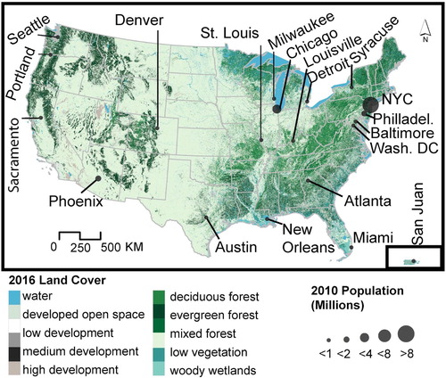
Table 1. A summary of the total number of plans and the range of years covered by the plans, by city. For plans with multiple or updated versions, we analyzed the most recent version of the plan.
Coding, prioritization and scale
We defined siting criteria as the project-scale, localized metrics, data, and considerations used to determine or identify in what neighborhoods or parcels to place GI. While decisions at the watershed/sewershed-scale occur, we were interested in how GI is located at the community level, as opportunities for benefits are localized. An initial non-case sensitive keyword search for ‘green infrastructure’ was run to identify relevant sections in the documents, after which we applied a descriptive coding regime that combined open and pattern coding in Atlas.TI software (Corbin & Strauss, Citation2014; Miles et al., Citation2014), with a short list of general siting criteria codes based on GI literature. We coded the plans iteratively, such that codes evolved to reflect new identified criteria, and allowed the assignment of multiple codes for text where appropriate.
All documents were reviewed by multiple coders to increase reliability, any disagreements were discussed until consensus was reached producing the final codebook (Appendix A). Categories were aggregated into larger themes for analysis, resulting in seven groups. When categories were highly diverse and contained a large quantity of coded content, we split these into subcategories. Criteria results are not weighted, but supplementary information on the percentage of siting criteria covered within the plans by city is provided (Appendix C). Henceforth, we italicize the categories and subcategories where mentioned. The seven groups are defined as follows:
Hydrologic (Hyd): criteria related to placing GI to manage the quality or quantity of stormwater, natural water systems, or availability.
Logistics (Log): in-vivo criteria related to placing GI based on physical observations, spatial constraints, professional expertize, or other opportunities.
Social (Soc): criteria related to placing GI based on resident or neighborhood engagement or involvement, increasing access to green space for cultural or social benefits, resident health, educational opportunities, or environmental justice or equity.
Economic (Ecn): criteria related to placing GI based on budget, cost, benefit–cost analysis, or opportunities for land or business development.
Transportation (Tsp): criteria related to placing GI along the right-of-way, based on pedestrian or traffic management, or department of transportation projects.
Environment (Env): criteria related to placing GI based on non-hydrologic environmental priorities or concerns such as increasing resiliency or improving air quality.
Other (Oth): criteria related to placing GI that could not be classified under the aforementioned groups or lacked specificity to be placed as a specific criteria category or subcategory.
Coded segments of text were exported and visualized using package ‘ggpubr’ in R (Kassambara, Citation2020; R Core Team, Citation2019), examining coding frequency and proportional distributions across cities. In the results section we present the results by group. Where direct quotations from the plans are used, the citation method follows the format of city-document #, page # (key available in Appendix B). In the discussion, we examine potential outcomes based on the criteria’s engagement with environmental justice.
Study limitations
While we believe it is important to identify and discuss the justice implications of siting criteria in formal planning documents, we recognize that they are only one part of the GI planning and implementation process. Research that examines how criteria are used in decision-making processes requires interviews with urban planners, engineers, and residents, as well as spatial mapping for siting validation. Interviews would also help verify an important assumption of this study, namely that the frequency of codes across planning documents is indicative of the relative importance cities place on siting criteria for the cities. Finally, evaluating the outcomes of current stormwater-driven GI planning practices is outside the scope of this study. However, research assessing the spatial distribution of GI implementation and the services and disservices communities receive from GI is critically needed to truly understand the breadth of justice-related implications.
Results: GI siting criteria
Our analysis comprised 1,805 coded entities across 12 categories and 35 subcategories. Results indicate that GI siting criteria are driven by technical criteria (e.g. feasibility, stormwater management), with a particular focus on managing flooding and runoff (). Of the 19 cities analysed, 16 cited hydrology or stormwater management, and all 19 used cost or economics as siting criteria. In comparison, seven cities explicitly mentioned environmental justice or equity as siting criteria, ().
Figure 2. Distribution of all siting criteria categories by frequency, where groups are represented as follows: Hydrologic (Hyd), Social (Soc), Economic (Ecn), Transportation (Tsp), Logistics (Log), Environment (Env) and Other (Oth). The figure highlights that hydrologic and logistic criteria are found much more frequently in plans than, for example, environment-related criteria.
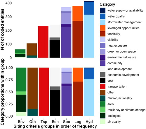
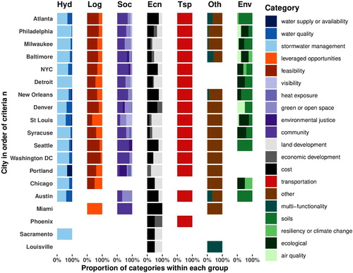
Figure 3. The proportionate distribution of siting criteria groups and categories by city, showing that criteria vary by city, but some categories are found in most cities (e.g. stormwater management), while others are limited to a few cities (e.g. environmental justice). Groups are represented as follows: Hydrologic (Hyd), Social (Soc), Economic (Ecn), Transportation (Tsp), Logistics (Log), Environment (Env) and Other (Oth).
Hydrologic criteria
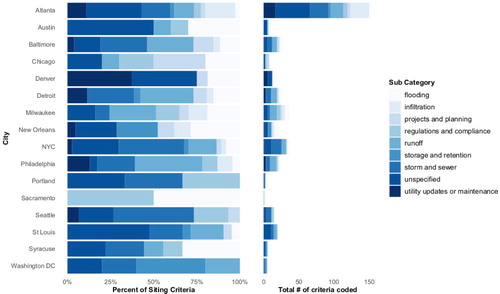
In line with the EPA’s definition of GI and previous research, many cities sited GI as a stormwater management strategy. GI siting criteria categories included stormwater management (n = 307), water quality (n = 93), and water supply or availability (n = 7). The largest category, stormwater management, contained nine subcategories (), the largest being runoff (n = 66) and storm and sewer (n = 59). The runoff subcategory included criteria targeting impervious areas, regulatory managed areas or managing overland flow. One example of how this criterion was discussed in plans included locating GI ‘based on their ability to mitigate these on-site flows' (AUS-06, 67). Under storm and sewer, siting criteria detailed locations where GI could reduce combined sewer overflows (CSOs) (e.g. inlets or outlets of the sewer system) or be ‘implemented in uncontrolled CSO basins where it is practical' (SEA-03, 3-70). Less common but still present were instances where siting criteria focused on municipal separate sewer systems (MS4).
Figure 4. The proportionate and frequency distribution of subcategories in the hydrologic group that fall under the stormwater management category by city showing which subcategories are most common and variation by city. Cities that did not contain any stormwater management subcategory criteria (Miami, Phoenix, and Louisville) are excluded from the figure.
Logistics criteria
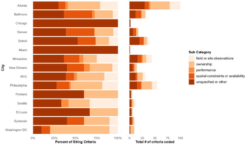
Logistics included two in-vivo codes: leveraged opportunities (n = 109) and feasibility (n = 270). Feasibility subcategories included spatial constraints or availability (n = 58), performance (n = 10), field observations (n = 61), unspecified or other (n = 28), and ownership (n = 113) (). Ownership captured planning language that prioritized city-owned land for GI, such as schools, streets, or parcels (e.g. ‘Projects within the street right-of-way (ROW) and/or City-owned parcels were considered priority locations' (ATL-04, appendix F, 2)). Field observations and spatial constraints or availability subcategories included site observations or specifications (e.g. ATL-09, 3-20; MWK-02, 15), prioritized parcels of a certain size (e.g. DEN-01, 31), or emphasized vacancy, which was cited by nine cities for ease of implementation (e.g. DTW-01, 92; NYC-01, 5). Note that vacancy was cross-coded with land development under the economic group.
Figure 5. The proportionate and frequency distribution of subcategories in the logistics group that fall under the feasibility category by city showing which subcategories are most common and variation by city. Cities that did not contain any feasibility subcategory criteria (Austin, Phoenix, Sacramento, and Louisville) are excluded from the figure.
Leveraged opportunities described the process of adding GI to projects already funded, planned, or in progress. Criteria were often discussed through cost-sharing (discussed and cross-coded in cost), current project site locations (for unrelated GI work), or established construction schedules. Examples of this include:
opportunities to partner with other COA departments to combine projects for cost-sharing will be considered as well. (ATL-10, 7-4)
Areas with existing GGI projects and the potential for economic development (BAL-03, 43)
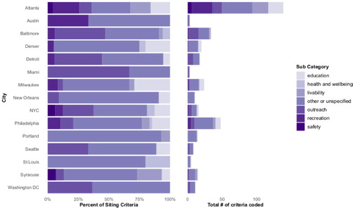
Social criteria
The third largest group, social categories, included community (n = 143), environmental justice (n = 21), heat exposure (n = 10), green or open space (n = 81), and visibility (n = 31). Community encompassed all resident-driven siting criteria and included seven subcategories: public outreach (n = 56), health and wellbeing (n = 6), education (n = 46), safety (n = 8), recreation (n = 43), livability (n = 32), and other or unspecified (n = 36) (). Environmental justice criteria accounted for just 1.2% of the total criteria coded, and were mentioned in 12 plans across seven cities: Atlanta, Baltimore, Denver, New York City, Philadelphia, Portland, and Seattle. Comparatively, Portland (n = 7) and Baltimore (n = 6) cited environmental justice criteria the most. We identified three ways environmental justice criteria was discussed (emphasis added):
Distribution of GI or amenities
Equitable distribution of implementation across City watersheds, neighborhoods, and demographics and potential to address environmental justice (BAL-03, 48)
Equitable spatial distribution of burdens and benefits (PHI-05, 3-3)
Use of demographic data
Also ensure that improvements help implement the City’s equity goals and strategies, especially as they relate to the history of impacts to Portland’s African-American community. (PDX-08, 104)
Evaluate grant funding to promote GI implementation on private property, focusing on low-income communities of color (ATL-01, 11)
Areas excluded from institutional investment and other metrics
Prioritize areas with historical and current underinvestment (PDX-02, 105)
Improving parks that have received little capital investment and are located in areas of high need, based on higher-than-average poverty, density, and population growth. (NYC-01, 164)
Figure 6. The proportionate and frequency distribution of subcategories in the social group that fall under the community category by city showing which subcategories are most common and variations by city. Cities that did not contain any community subcategory criteria (Chicago, Phoenix, Sacramento, and Louisville) are excluded from the figure.
Additionally, several heat exposure citations were cross-coded with environmental justice, but lacked specificity. These included siting GI in hotter areas to alleviate the impacts of heat on communities (e.g. ‘neighborhoods with populations at higher risk of adverse outcomes of urban heat island effects' (PDX-02, 104)). One plan cited ‘basic maps showing vulnerable populations and locations in the city based on the urban heat island effect' (BAL-10, 20), but did not provide a definition of vulnerable populations. Philadelphia and Syracuse cited criteria to reduce heat or provide shade but did not specify which neighborhoods or populations to prioritize, and Denver had criteria based on social determinants of health (DEN-01, 12), families in poverty, and education disparities (DEN-01, 101). The remaining citations for heat cited reducing the urban heat island.
Outreach, criteria driven by resident input (e.g. surveys or focus groups), was the largest community subcategory, and primarily referenced feedback from neighborhoods with prior engagement with the city, or 311 complaints. For example:
With respect to green infrastructure, a variety of factors are used to determine the priority of a project. This includes, reports of street flooding, basement backup claims data, community engagement/neighborhood participation. (DTW-03, 11-5)
The second largest category, green and open space, primarily discussed siting GI for green space in three ways. Fist, siting GI in or near parks as retrofits, improvements, or preferring areas closer to parks; second, as an overall goal to increase the percent canopy cover or greenspace across the city; third, as a focused or more specific investment in areas with low canopy over/park density, higher surface temperatures, or access. There was also one instance of a city’s green network plan ‘aligning infrastructure investments with communities in need' (BAL-02, 9).
The visibility category sited locations to showcase or demonstrate the function or use of GI to educate the public or build support for continued GI projects. Recreation criteria largely focused on adding GI alongside bicycle or trail connectivity projects or initiatives, and was frequently cross-coded with transportation and the subcategory livability. Under health and wellbeing, the most specific metrics for determining GI location were recreational beaches near outfall locations (NYC-02, 160), or neighborhoods with relatively higher rates of child and adult obesity, and relatively lower life expectancy (DEN-01, 101). Safety criteria, primarily discussed by Atlanta (6 out of 8 citations), sited GI based on their proximity to parks, schools, roads or sewer infrastructure. For example, Syracuse sited GI as a supportive infrastructure to provide safe walking routes to/from schools/parks. For roads/sewers, while not explained, Atlanta referenced protection and enhancement to existing infrastructure, ranked by GI’s proximity to sewer projects.
Economic criteria
The economic group included land development (n = 94), economic development (n = 17) and cost (n = 131) categories. Land development referred to new or re-development construction, including vacant lots. Economic development included criteria targeting GI in areas for desired or increased business opportunities, job creation or economic growth, including prioritizing GI in tax increment financing (TIF) zones. The largest category, cost, contained five subcategories (): available funding and budget (n = 21), property value (n = 2), types of costs (n = 32), services/effectiveness/sharing (n = 50), and unspecified or other (n = 26). Types of costs included criteria such as specific construction or calculation costs for a project, unspecified or other was coded if a plan indicated that ‘cost’ was important but did not state how or what types of costs were used in determining that importance. For example, an Atlanta plan states ‘Cost is usually a major determining factor in the prioritization of projects.' (ATL-08, appendix H, 2), but provides no explanation for how cost is weighted against other criteria. Available funding and budget referenced specific grant or funding lines on a per project basis or total funding.
Figure 7. The proportionate and frequency distribution of subcategories in the economic group that fall under the cost categories by city showing which subcategories are most common and variations by city. All 19 cities contain cost subcategory criteria.
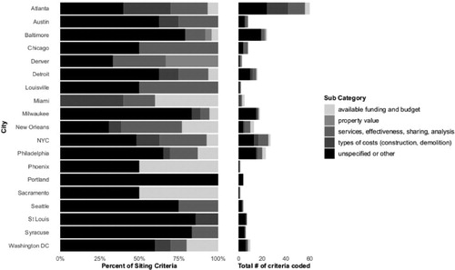
Cost-effectiveness (under subcategory services, effectiveness, sharing, analysis) was most frequently cited but rarely defined, as exhibited in the response to a public comment asking for a definition (bolding added).
There is no single definition or criterion for cost-effectiveness that the City can apply; all financial aspects of each individual project must be considered in combination. (NYC-02, 270)
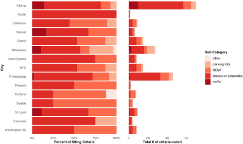
Transportation criteria
Transportation emerged as an important theme during the coding process. Categories included streets and sidewalks (n = 138), parking lots (n = 23), traffic (n = 16), the right-of-way (ROW) (n = 54), and other (n = 2) (). Parking lots criteria sited GI for both private and publicly owned parking lots. Under traffic, GI aimed to reduce vehicle flow, speed, or density, ROW referred to locating GI in the right-of-way, and streets and sidewalks sited GI on bike lanes, trails and green streets. GI was often prioritized on publicly-owned land, and streets and parking lots certainly represent a large share of public space in cities. A recent study of Phoenix, for example, estimated that 10% of the urban area was devoted to parking alone (Hoehne et al., Citation2019). Streets and sidewalks was the largest transportation subcategory, suggesting these are common locations for GI.
Figure 8. The proportionate and frequency distribution of transportation subcategories by city showing which subcategories are most common and variations by city. Cities that did not contain any transportation subcategory criteria (Chicago, Miami, Sacramento, and Louisville) are excluded from the figure.
Other & environment criteria
The environment group () encompassed ecological criteria that did not pertain to water such as air quality (n = 5) and ecological habitat (n = 22). The other group contained principles (n = 5), which involved ‘[i]dentifying and selecting projects that embody the principles of living with water' (MSY-02, 13), transitional (n = 3) criteria such as ‘currently un-developed and present an opportunity for providing habitat until such time in the future as economic conditions make them desirable for development' (STL-02, 14), and exclude (n = 32) criteria of areas not to place GI.
Discussion: justice implications of GI siting criteria
We now discuss how these criteria explicitly or implicitly engage with justice and the implications, concluding with recommendations for future GI planning. Criteria with explicit justice engagement focused on siting GI to improve minoritized communities, repair past injustices, or prevent future harm. Implicit engagement included criteria inextricably linked to broader social processes and patterns of inequality. For example, if a plan states an intention to increase residential park access but does not explicitly acknowledge the historical racist patterns of park distribution or lesser quality parks, it is classified as implicit engagement with justice.
Explicit engagement with justice
While social criteria represented the second largest thematic group, environmental justice criteria only accounted for 1.2% of all criteria, and when including heat, health or well-being 2.0%. Given the low prevalence of explicit criteria engaging justice, the ways in which GI gets sited (or not) in minoritized communities may not result in just outcomes (e.g. focusing on amenity investments without addressing underlying structural issues accelerating harm).
Our analysis also suggests that community engagement or outreach tends to be passive, commonly based on existing complaints or relationships. For example, GI was often promoted on public school property, which seems positive, but plans left unstated which school districts would be prioritized. US schools are notoriously segregated, and schools with large minority populations are under resourced (Jonathan Kozol, Citation1991; Meckler, Citation2019). Moving outreach efforts to an active engagement approach is achievable and could be done by giving higher weight or rank to community priorities and having explicit and clear processes for negotiating conflicts between city and community needs.
We see many ways in which commonly identified siting criteria could exclude minoritized communities from GI development, while other criteria might prioritize them inadvertently. The specific types of GI prioritized in the plans is outside the scope of this study, but it is worth noting that if hydrologic benefits are prioritized, GI features could be selected (e.g. permeable pavement) that provide minimal vegetation or co-benefits to communities most in need. One recent study showed that despite widespread implementation of GI in Philadelphia, overall ‘greenness’ was reduced (Spahr et al., Citation2020), while another chronicles the loss of Black-owned homes and lands at the expense of green sustainable housing (Aidoo, Citation2021).
Given the increasing literature demonstrating strong positive correlations between higher temperatures, heat-related health risks, and neighborhoods with majority residents of color or of lower-income (e.g. Keeler et al., Citation2019; Wilson, Citation2020), cities could more clearly acknowledge the justice implications of prioritizing hotter areas for GI.
Without more explicit focus on justice, we argue that GI siting runs the risk of replicating larger patterns of uneven urban infrastructure development, potentially resulting in green gentrification, displacement, and cultural loss (Anguelovski et al., Citation2019, Citation2020), which research shows disadvantages residents and communities of color (Heck Citation2021).
Implicit engagement with justice
Consistent with previous US-based single-site case studies (Finewood et al., Citation2019; Meerow, Citation2020; Newell et al., Citation2013; Heck Citation2021), more technocratic criteria, namely stormwater management, proliferate in GI siting decisions. In this way, the need for GI is based largely on characteristics of the built environment (e.g. imperviousness or sewer type) or the larger hydrologic system, rather than on the communities that live there and their distinct needs, relationships, or preferences (Meerow, Citation2020). Additional technocratic criteria included logistics criteria, such as leveraged opportunities, that placed GI into other in-progress or planned projects.
Similarly, the emphasis on cost-effectiveness/sharing, in practice, seems unlikely to benefit minoritized communities. Wealthier resident associations are more likely to have the capital to cost-share for GI development. Conversely, while the racist devaluing of land in Black and brown neighborhoods could make those spaces more cost-effective for GI, as Heck (Citation2021) argues, those cost savings replicate long-standing underinvestment in these areas. The ambiguous response to defining cost-effectiveness highlights the lack of transparency and continued ambiguity in how cities use, define, or weigh cost-effectiveness. While this ambiguity could allow for flexibility in project assessment, it seems doubtful given recent work on how drivers like cost-effectiveness actually mirror historical patterns of dis/under-investment in minoritized communities (Heck, Citation2021).
The use of GI as a placeholder for future development (e.g. ‘short-term beautification while holding parcels for long-term development opportunities.' BAL-02, 6), has both positive and negative justice implications. If or when the parcel(s) become commercially marketable, the GI could be replaced by a community-desired or identified business (e.g. grocery store). Conversely, if land values increased, the GI might be replaced by an undesired commercial development (e.g. luxury condos).
A similar logic applies to transportation criteria. Linking GI planning to transportation projects may exacerbate current and historical disinvestment in minoritized communities. Plans rarely discussed how they would determine which streets or sidewalks to enhance with GI through transit (e.g. neighborhoods or street types), and research suggests transportation investments often prioritize wealthier and whiter communities (Golub et al., Citation2013). Other research suggests that road resurfacing projects, sidewalk expansion, or bike and trail lanes, while done in an attempt to enhance active transportation, tend not to prioritize minoritized communities perpetuating inequalities across the landscape (Knight et al., Citation2018; Lee et al., Citation2017), and may serve as harbingers of gentrification (Flanagan et al., Citation2016).
Envisioning more just green infrastructure spatial planning
To avoid perpetuating inequities through the development of green infrastructure, cities should explicitly center justice in their GI spatial planning. We suggest that any GI planning effort should 1) prioritize GI in communities that have a want or need for it and are supportive of GI as a solution, 2) have methods and criteria that match stated justice goals, and 3) be implemented alongside policies or regulations that address systemic racism in planning.
Prioritizing GI in communities that want and support it
Trust is the foundation to any functioning relationship and cities and their residents are no different. Particularly when it comes to justice, trust between cities and minoritized communities has generally been non-existent (Jardine et al., Citation2013). Given this history, the path towards justice is one where cities cede the power of self-determination to these communities, identifying if/where/what GI practices residents desire through outreach. Examples of this include community-led planning activities that include historic preservation mapping, walking paths, needs identification, or participatory-mapping (Allen et al., Citation2019). Implementing GI based on how residents experience their environment and in turn using those experiences to inform the metrics for siting is a key tenet to justice-centered planning.
When it comes to GI siting, minoritized residents must be invited to the siting process at the beginning of the planning stages (as opposed to informational meetings at 30/60/90 percent project completion), and given priority over city criteria and preferences. Radical planning theory argues for the need to consider lived experiences as knowledge, created through dialogue, and to use it to inform planning (Jacobs, Citation2019). This is particularly critical for planning to mitigate disasters like stormwater-related flooding, where community voices are frequently ignored, and conversations of social vulnerability fail to focus on the ways white supremacy and sexism are amplified by environmental hazards (Jacobs, Citation2019). It was promising to see many references to public outreach in the plans, but it is insufficient to prioritize GI based on 311 complaints alone. Plans should outline steps to ensure residents feel comfortable participating in city governance. In fact, research suggests that procedural justice is critical in order to avoid harm (cultural, social, and economic) (Finewood et al., Citation2019; O’Brien et al., Citation2017; Rigolon & Németh, Citation2018). This can be done via resident steering communities, closely partnering with local non-profits and activist organizations rooted in the neighborhoods of interest and delivering on city support for the outlined needs or priorities of residents. Citing Jacobs (Citation2019) again, the integration of critical race theory (Price, Citation2010) alongside radical planning methods are fundamental to understanding and preventing production and reproduction of environmental injustices.
Matching goals to methods for prioritizing GI siting
The limited, explicit engagement with justice among the GI siting criteria seems problematic given the growing calls for social and environmental justice in green infrastructure planning (Shi, Citation2020). Embedding GI projects in transportation, capital projects, or other processes, which our findings suggest is commonplace, is unlikely to answer these calls. Planning of transportation and capital projects are inextricably tied to persistent racial injustice and inequities, and both have been shown to privilege white and wealthier neighborhoods (Golub et al., Citation2013; Knight et al., Citation2018). We also recognize the importance of shared governance and the opportunities for GI practices presented by increased communication and resource sharing among city departments, agencies, and organizations. However, shared resources for GI planning will only be meaningful if planned and sited in just ways.
Given the reduced financial resources – institutional and personal – that many minoritized communities experience, one restorative justice practice could include dedicated funds for GI maintenance or other needs when GI is located in minoritized communities. A consistent and reliable maintenance budget is an important supplement to balance historical financial overinvestment in predominantly white and wealthy neighborhoods. Where specific justice criteria are absent, having funding for GI free from other development (e.g. funding through impact fees) or investments (e.g. street upgrades) is a vital piece of moving towards justice. Dedicated funds can specifically address disparities that embedded GI practices alone will not address. In the absence of specific funding lines (e.g. for community supported GI siting or GI maintenance), our prediction is that GI will mirror the funding pathways of other infrastructure or capital investment projects. As such, establishing a budget exclusively for the maintenance and monitoring of GI placed in minoritized communities is a key recommendation.
Implementing GI with policies that intentionally address legacies of racism
Equal siting of GI is insufficient to address long-standing disparities in urban amenities and does not take into account the local context or history (Heckert & Rosan, Citation2016). We argue GI should only be prioritized in communities that are supportive of GI as a solution, while mitigating any community concerns (e.g. green gentrification) through proactive planning and policies. For example, displacement is a predictable outcome that can be addressed (Rigolon & Németh, Citation2018). Finally, we call for planners, geographers, and other social scientists to further examine justice in GI planning decisions, and what the long-term impacts are to the communities where GI is placed.
Conclusion
GI has become an increasingly popular approach for enhancing urban sustainability and resilience. The history of urban planning ‘solutions’ is fraught with injustices. As more cities integrate GI into their various plans and invest in its expansion it inevitably raises justice concerns. The spatial planning of GI can itself be seen as an issue of distributional environmental justice, as the impacts are mostly localized. Drawing on a novel dataset of qualitatively coded city planning documents from 19 diverse US cities, this study sought to specifically examine how cities intend to site GI. We identify many different spatial siting criteria outlined in the plans, most of which are highly technical or economic; justice is not a focus in GI siting priorities. To center justice in GI planning efforts, we recommend cities 1) prioritize GI in communities that either want, need or support GI, 2) have stated justice goals and the methods and criteria to match, and 3) implement GI alongside policies or regulations that address systemic racism in planning.
Acknowledgements
We gratefully acknowledge the support of The JPB Foundation for this work, through a project entitled “Environment, Health, and Poverty: Is Green Infrastructure a Universal Good?”.
Disclosure statement
No potential conflict of interest was reported by the author(s).
Additional information
Funding
Notes on contributors
Fushcia-Ann Hoover
Dr. Fushcia-Ann Hoover is a transdisciplinary researcher specializing in social-environmental urban systems, environmental justice, green infrastructure and planning. Her research centers equity and justice in urban planning and engages the racial histories and relationships between people, place and the environment. She is an Assistant Professor in Geography and Earth Sciences at the University of North Caroline-Charlotte, and a faculty affiliate with the Central Arizona-Phoenix Long-Term Ecological Research (CAP-LTER) program.
Sara Meerow
Dr. Sara Meerow is an interdisciplinary researcher working at the intersection of urban geography and planning on how to make cities more resilient to climate change and other social and environmental hazards in ways that are sustainable and just. She is an Assistant Professor in the School of Geographical Sciences and Urban Planning at Arizona State University.
Zbigniew J. Grabowski
Dr. Zbigniew J. Grabowski is a transdisciplinary researcher focused on enabling just transitions of socio-eco-technical systems. He has expertise in human and physical geography, biocultural conservation, hydrology, ecosystem and environmental science, and infrastructure studies. He is a Postdoctoral Research Associate at the Cary Institute of Ecosystem Studies, a Visiting Scholar at the Urban Systems Lab, and an Adjunct Assistant Professor at Portland State University.
Timon McPhearson
Dr. Timon McPhearson is an urban ecologist with expertise in urban data science, climate change risk, and nature-based solutions for urban resilience and sustainability. He is Director of the Urban Systems Lab, Associate Professor of Urban Ecology at The New School, and a Research Fellow at The Cary Institute of Ecosystem Studies and Stockholm Resilience Centre.
References
- Aidoo, F. S. (2021). Architectures of mis/managed retreat: Black land loss to green housing gains. Journal of Environmental Studies and Sciences. https://doi.org/https://doi.org/10.1007/s13412-021-00684-3
- Allen, D., Lawhon, M., & Pierce, J. (2019). Placing race: On the resonance of place with black geographies. Progress in Human Geography, 43(6). https://doi.org/10.1177/0309132518803775
- Anguelovski, I., Brand, A. L., Connolly, J. J. T., Corbera, E., Kotsila, P., Steil, J., Garcia-Lamarca, M., Triguero-Mas, M., Cole, H., Baró, F., Langemeyer, J., del Pulgar, C. P., Shokry, G., Sekulova, F., & Argüelles Ramos, L. (2020). Expanding the boundaries of justice in urban greening scholarship: Toward an emancipatory, antisubordination, intersectional, and relational approach. Annals of the American Association of Geographers, 110(6), 1743–1769. https://doi.org/https://doi.org/10.1080/24694452.2020.1740579
- Anguelovski, I., Connolly, J. J., Garcia-Lamarca, M., Cole, H., & Pearsall, H. (2019). New scholarly pathways on green gentrification: What does the urban ‘green turn’ mean and where is it going? Progress in Human Geography, 43(6), 1064–1086. https://doi.org/https://doi.org/10.1177/0309132518803799
- Benedict, M. A., & McMahon, E. T. (2002). Green infrastructure: Smart conservation for the 21 century. Renewable Resources Journal, Autumn, 20(3), 12–18.
- Bowen, K. J., & Lynch, Y. (2017). The public health benefits of green infrastructure: The potential of economic framing for enhanced decision-making. Current Opinion in Environmental Sustainability, 25, 90–95. https://doi.org/https://doi.org/10.1016/j.cosust.2017.08.003
- Bullard, R. D. (1996). Environmental justice: It’s more than waste facility siting. Social Science Quarterly, 77(3), 493–499. https://www.jstor.org/stable/42863495
- Corbin, J., & Strauss, A. (2014). Basics of qualitative research (4th ed.). Sage Publications. https://us.sagepub.com/en-us/nam/basics-of-qualitative-research/book235578
- Cousins, J. J. (2021). Justice in nature-based solutions: Research and pathways. Ecological Economics, 180, 106874. https://doi.org/https://doi.org/10.1016/j.ecolecon.2020.106874
- Elmqvist, T., Gomez-Baggethun, E., & Langemeyer, J. (2016). Ecosystem services provided by urban green infrastructure. In Handbook of ecosystem services (1st ed., p. 630). Routledge.
- Feyisa, G. L., Dons, K., & Meilby, H. (2014). Efficiency of parks in mitigating urban heat island effect: An example from Addis Ababa. Landscape and Urban Planning, 123, 87–95. https://doi.org/https://doi.org/10.1016/j.landurbplan.2013.12.008
- Finewood, M. H., Matsler, A. M., & Zivkovich, J. (2019). Green infrastructure and the hidden politics of urban stormwater governance in a postindustrial city. Annals of the American Association of Geographers, 109(3), 909–925. https://doi.org/https://doi.org/10.1080/24694452.2018.1507813
- Fitzgerald, J., & Laufer, J. (2017). Governing green stormwater infrastructure: The Philadelphia experience. Local Environment, 22(2), 256–268. https://doi.org/https://doi.org/10.1080/13549839.2016.1191063
- Flanagan, E., Lachapelle, U., & El-Geneidy, A. (2016). Riding tandem: Does cycling infrastructure investment mirror gentrification and privilege in Portland, OR and Chicago, IL? Transportation and Land Development: A Global View, 60, 14–24. https://doi.org/https://doi.org/10.1016/j.retrec.2016.07.027
- Glotzer, P. (2015). Exclusion in arcadia: How suburban developers circulated ideas about discrimination, 1890–1950. Journal of Urban History, 41(3), 479–494. https://doi.org/https://doi.org/10.1177/0096144214566964
- Golub, A., Marcantonio, R. A., & Sanchez, T. W. (2013). Race, space, and struggles for mobility: Transportation impacts on African Americans in oakland and the east Bay. Urban Geography, 34(5), 699–728. https://doi.org/https://doi.org/10.1080/02723638.2013.778598
- Gould, K. A., & Lewis, T. L. (2017). Green gentrification: Urban sustainability and the struggle for environmental justice (1st ed.). Routledge.
- Grove, M., Ogden, L., Pickett, S., Boone, C., Buckley, G., Locke, D. H., Lord, C., & Hall, B. (2018). The Legacy effect: Understanding How segregation and environmental injustice unfold over time in Baltimore. Annals of the American Association of Geographers, 108(2), 524–537. https://doi.org/https://doi.org/10.1080/24694452.2017.1365585
- Hansen, R., Olafsson, A. S., van der Jagt, A. P. N., Rall, E., & Pauleit, S. (2019). Planning multifunctional green infrastructure for compact cities: What is the state of practice? From Urban Sprawl to Compact Green Cities – Indicators for Multi-Scale and Multi-Dimensional Analysis, 96(Part 2), 99–110. https://doi.org/10.1016/j.ecolind.2017.09.042
- Heck, S. (2021). Greening the color line: Historicizing water infrastructure redevelopment and environmental justice in the St. Louis metropolitan region. Journal of Environmental Policy & Planning, 1–16. https://doi.org/https://doi.org/10.1080/1523908X.2021.1888702
- Heckert, M., & Rosan, C. D. (2016). Developing a green infrastructure equity index to promote equity planning. Urban Forestry and Urban Greening, 19, 263–270. https://doi.org/https://doi.org/10.1016/j.ufug.2015.12.011
- Hoehne, C. G., Chester, M. V., Fraser, A. M., & King, D. A. (2019). Valley of the sun-drenched parking space: The growth, extent, and implications of parking infrastructure in phoenix. Cities, 89, 186–198. https://doi.org/https://doi.org/10.1016/j.cities.2019.02.007
- Holifield, R. (2013). Defining environmental justice and environmental racism. Urban Geography, 22(1), 78–90. https://doi.org/10.2747/0272-3638.22.1.78
- Hoover, F.-A., & Hopton, M. E. (2019). Developing a framework for stormwater management: Leveraging ancillary benefits from urban greenspace. Urban Ecosystems, 22(6), 1139–1148. https://doi.org/https://doi.org/10.1007/s11252-019-00890-6
- Hoover, F.-A., & Lim, T. C. (2020). Examining privilege and power in US urban parks and open space during the double crises of antiblack racism and COVID-19. Socio-Ecological Practice Research, 1(3), 1–16. https://doi.org/10.1007/s42532-020-00070-3
- Hopkins, K. G., Grimm, N. B., & York, A. M. (2018). Influence of governance structure on green stormwater infrastructure investment. Environmental Science and Policy, 84, 124–133. USGS Publications Warehouse. https://doi.org/https://doi.org/10.1016/j.envsci.2018.03.008
- Jacobs, F. (2019). Black feminism and radical planning: New directions for disaster planning research. Planning Theory, 18(1), 24–39. https://doi.org/https://doi.org/10.1177/1473095218763221
- Jardine, C. G., Banfield, L., Driedger, S. M., & Furgal, C. M. (2013). Risk communication and trust in decision-maker action: A case study of the giant mine remediation plan. International Journal of Circumpolar Health, 72(1). https://doi.org/https://doi.org/10.3402/ijch.v72i0.21184
- Jonathan Kozol. (1991). Savage inequalities: Children in america’s schools (1st ed.). Crown.
- Kassambara, A. (2020). ggpubr: “ggplot2” Based Publication Ready Plots (0.4.0) [Computer software]. https://CRAN.R-project.org/package=ggpubr
- Keeler, B. L., Hamel, P., McPhearson, T., Hamann, M. H., Donahue, M. L., Meza Prado, K. A., Arkema, K. K., Bratman, G. N., Brauman, K. A., Finlay, J. C., Guerry, A. D., Hobbie, S. E., Johnson, J. A., MacDonald, G. K., McDonald, R. I., Neverisky, N., & Wood, S. A. (2019). Social-ecological and technological factors moderate the value of urban nature. Nature Sustainability, 2(1), 29–38. https://doi.org/https://doi.org/10.1038/s41893-018-0202-1
- Knight, J., Weaver, R., & Jones, P. (2018). Walkable and resurgent for whom? The uneven geographies of walkability in Buffalo, NY. Applied Geography, 92, 1–11. https://doi.org/https://doi.org/10.1016/j.apgeog.2018.01.008
- Kremer, P., Hamstead, Z. A., & McPhearson, T. (2016). The value of urban ecosystem services in New York City: A spatially explicit multicriteria analysis of landscape scale valuation scenarios. Environmental Science and Policy, 62, 57–68. https://doi.org/https://doi.org/10.1016/j.envsci.2016.04.012
- Lee, R. J., Sener, I. N., & Jones, S. N. (2017). Understanding the role of equity in active transportation planning in the United States. Transport Reviews, 37(2), 211–226. https://doi.org/https://doi.org/10.1080/01441647.2016.1239660
- Lipstiz, G. (2007). The racialization of space and the spatialization of race; theorizing the hidden architecture of landscape. Landscape Journal, 26(1), 10–23.
- Locke, D., Hall, B., Grove, J. M., Pickett, S. T. A., Ogden, L. A., Aoki, C., Boone, C. G., & O’Neil-Dunne, J. P. (2020). Residential housing segregation and urban tree canopy in 37 US Cities [Preprint]. SocArXiv. https://doi.org/https://doi.org/10.31235/osf.io/97zcs
- Lopez, B., Kennedy, C., & McPhearson, T. (2020). Parks are Critical Urban Infrastructure: Perception and Use of Urban Green Spaces in NYC During COVID-19. https://doi.org/https://doi.org/10.20944/preprints202008.0620.v1
- Lovell, S. T., & Taylor, J. R. (2013). Supplying urban ecosystem services through multifunctional green infrastructure in the United States. Landscape Ecology, 28(8), 1447–1463. https://doi.org/https://doi.org/10.1007/s10980-013-9912-y
- Mabon, L., & Shih, W.-Y. (2018). What might ‘just green enough’ urban development mean in the context of climate change adaptation? The case of urban greenspace planning in Taipei Metropolis, Taiwan. World Development, 107, 224–238. https://doi.org/https://doi.org/10.1016/j.worlddev.2018.02.035
- Matsler, A. M., Meerow, S., Mell, I. C., & Pavao-Zuckerman, M. A. (2021). A ‘green’ chameleon: Exploring the many disciplinary definitions, goals, and forms of “green infrastructure”. Landscape and Urban Planning, 214. https://doi.org/10.1016/j.landurbplan.2021.104145
- Meckler, L. (2019, February 26). Report finds $23 billion racial funding gap for schools. Washington Post. https://www.washingtonpost.com/local/education/report-finds-23-billion-racial-funding-gap-for-schools/2019/02/25/d562b704-3915-11e9-a06c-3ec8ed509d15_story.html
- Meerow, S. (2020). The politics of multifunctional green infrastructure planning in New York City. Cities, 100. https://doi.org/https://doi.org/10.1016/j.cities.2020.102621
- Miles, M., Huberman, A. M., & Saldana, J. (2014). Fundamentals of Qualitative data analysis. In Qualitative data analysis, A methods sourcebook (3rd ed., pp. 69–104). Sage Publications.
- Newell, J. P., Seymour, M., Yee, T., Renteria, J., Longcore, T., Wolch, J. R., & Shishkovsky, A. (2013). Green alley programs: Planning for a sustainable urban infrastructure? Cities, 31, 144–155. https://doi.org/https://doi.org/10.1016/j.cities.2012.07.004
- O’Brien, L., De Vreese, R., Atmiş, E., Stahl Olafsson, A., Sievänen, T., Brennan, M., Sánchez, M., Panagopoulos, T., de Vries, S., Kern, M., Gentin, S., Saraiva, G., & Almeida, A. (2017). Social and environmental justice: Diversity in access to and benefits from Urban green infrastructure – Examples from Europe. In D. Pearlmutter, C. Calfapietra, R. Samson, L. O’Brien, S. Krajter Ostoić, G. Sanesi, & R. Alonso del Amo (Eds.), The urban forest: Cultivating green infrastructure for people and the environment (pp. 153–190). Springer International Publishing. https://doi.org/https://doi.org/10.1007/978-3-319-50280-9_15
- Pietila, A. (2012). Not in my neighborhood: How bigotry shaped a great American city. Rowman & Littlefield.
- Price, P. L. (2010). At the crossroads: Critical race theory and critical geographies of race. Progress in Human Geography, 34(2), 147–174. https://doi.org/https://doi.org/10.1177/0309132509339005
- Pulido, L. (2000). Rethinking environmental racism: White privilege and urban development in southern california. Annals of the Association of American Geographers, 90(1), 12–40. https://doi.org/https://doi.org/10.1111/0004-5608.00182
- R Core Team. (2019). R: A language and environment for statistical computing. R Foundation for Statistical Computing. https://www.R-project.org/
- Rigolon, A., & Németh, J. (2018). “We’re not in the business of housing:” environmental gentrification and the nonprofitization of green infrastructure projects. Cities, 81, https://doi.org/https://doi.org/10.1016/j.cities.2018.03.016
- Rothstein, R. (2017). The color of Law: A forgotten history of How Our government segregated america. Liveright Publishing.
- Schell, C. J., Dyson, K., Fuentes, T. L., Des Roches, S., Harris, N. C., Miller, D. S., Woelfle-Erskine, C. A., & Lambert, M. R. (2020). The ecological and evolutionary consequences of systemic racism in urban environments. Science, 369(6510), eaay4497. https://doi.org/https://doi.org/10.1126/science.aay4497
- Schlosberg, D. (2007). Defining environmental justice: Theories, movements, and nature. Oxford University Press.
- Shi, L. (2020). Beyond flood risk reduction: How can green infrastructure advance both social justice and regional impact? Socio-Ecological Practice Research, 2(4), 311–320. https://doi.org/https://doi.org/10.1007/s42532-020-00065-0
- Spahr, K. M., Bell, C. D., McCray, J. E., & Hogue, T. S. (2020). Greening up stormwater infrastructure: Measuring vegetation to establish context and promote cobenefits in a diverse set of US cities. Urban Forestry & Urban Greening, 48, 126548. https://doi.org/https://doi.org/10.1016/j.ufug.2019.126548
- US EPA. (2015, September 30). What is Green Infrastructure? [Overviews and Factsheets]. US EPA. https://www.epa.gov/green-infrastructure/what-green-infrastructure
- US EPA, O. (2014, November 3). Environmental Justice [Collections and Lists]. US EPA. https://www.epa.gov/environmentaljustice
- von Döhren, P., & Haase, D. (2015). Ecosystem disservices research: A review of the state of the art with a focus on cities. Ecological Indicators, 52, 490–497. https://doi.org/https://doi.org/10.1016/j.ecolind.2014.12.027
- Wilson, B. (2020). Urban heat management and the Legacy of redlining. Journal of the American Planning Association, 86(4), 443–457. https://doi.org/https://doi.org/10.1080/01944363.2020.1759127
- Wolch, J. R., Byrne, J., & Newell, J. P. (2014). Urban green space, public health, and environmental justice: The challenge of making cities “just green enough.”. Landscape and Urban Planning, 125, 234–244. https://doi.org/https://doi.org/10.1016/j.landurbplan.2014.01.017
- Zhao, Q., Sailor, D. J., & Wentz, E. A. (2018). Impact of tree locations and arrangements on outdoor microclimates and human thermal comfort in an urban residential environment. Urban Forestry & Urban Greening, 32, 81–91. https://doi.org/https://doi.org/10.1016/j.ufug.2018.03.022
- Zuniga-Teran, A. A., Gerlak, A. K., Mayer, B., Evans, T. P., & Lansey, K. E. (2020). Urban resilience and green infrastructure systems: Towards a multidimensional evaluation. Current Opinion in Environmental Sustainability, 44, 42–47. https://doi.org/https://doi.org/10.1016/j.cosust.2020.05.001