
ABSTRACT
Worldwide, more integrated and spatially embedded forms of flood risk management have been advocated. In the Netherlands, this ‘spatial turn’ can be associated with a quest for spatial quality, i.e. making use of existing landscape values to create more liveable, aesthetic and sustainable flood risk management solutions. Reflecting on Dutch flood risk management practice, this paper inventorizes which policy instruments are currently used to strengthen spatial quality, and how involved actors view these instruments. We present empirical insights on common concerns, standpoints and dilemmas from the Dutch Flood Protection Programme (DFPP), a large-scale reinforcement operation to climate-proof the Netherlands’ main flood defences by 2050. Spatial quality here remains a rather ambiguous policy objective, lacking a legally binding framework. Using the NATO-policy instruments’ typology as a starting point, and based on a co-learning process between science and practice, we present an instruments palette that can be used to strengthen spatial quality in flood risk management. Our findings reveal that the DFPP makes use of rather ‘soft’ policy instruments. The actual achievement of spatial quality goals seems to depend largely on the combined project team competencies, guidance and support provided by responsible water authorities, and commitment of other project partners.
1. Introduction
Across borders, environmental quests for energy transition, circular agriculture, sustainable mobility and climate-proof flood management increase the pressure on space, asking for sustainable governance practices (Schaub et al., Citation2022). With different interests competing for space, worries about spatial quality – broadly referring to the liveability, aesthetics and sustainability of places – arises.
A concern for quality and the beauty of the landscape is key to many planning cultures, but the exact wording often differs (Healey, Citation2010; Stöglehner, Citation2019). Examples from the Anglo-American context are ‘landscape quality’ (Daniel, Citation2001), ‘good design’ (Sternberg, Citation2000), ‘quality of place’ (Healey, Citation2004) or ‘environmental quality’ (Cropper & Griffiths, Citation1994), whereas in Dutch and Flemish planning the term ‘spatial quality’ is a frequently used concept (Janssen-Jansen et al., Citation2009; Moulaert et al., Citation2013). Also on the European level, recent developments such as the ‘New European Bauhaus’, an initiative by the European Commission to support local authorities in implementing quality principles for the built environment, manifests the growing attention for (spatial) quality (Sadowski, Citation2021). However, spatial interventions usually emerge from other policy targets, such as affordable housing or improved flood risk management. Therefore, spatial quality requires cooperation between multiple sectors and actors. Achieving spatial quality can hence be considered a governance challenge that requires adequate policy tools, in particular, in a technically dominated field like flood risk management (Busscher et al., Citation2019).
Focusing on policy instruments for spatial quality in flood risk management also provides an opportunity to contribute to the knowledge gap on policy tools for spatial governance that Stead (Citation2021) identified. He argued that planning scholars have often focused on regulatory instruments (such as Environmental Impact Assessments) or informal-communicative instruments (such as ‘round tables’), whereas other insights and frameworks from policy sciences are largely overlooked in planning literature. One such framework is the NATO-framework, which distinguishes between four different types of policy instruments: nodality, authority, treasure and organization (in short ‘NATO’ – Hood, Citation1986; Howlett & Rayner, Citation2007). The NATO-framework offers the possibility to study the full range of policy instruments, including more market-based and organization-oriented instruments, and how they interact with each other in so-called ‘policy mixes’ (Howlett & Rayner, Citation2007; Verweij et al., Citation2021). Before such evaluation, first, an inventory of policy instruments is needed. Reflecting on Dutch flood risk management practice, the central question of this paper therefore is: Which policy instruments are currently used to strengthen spatial quality, and how do involved actors view these instruments?
We present the case of the Dutch Flood Protection Programme (DFPP, in Dutch ‘Hoogwaterbeschermingsprogramma’) to gain insight into policy instruments for spatial quality in the specific policy domain of flood risk governance. The DFPP entails the largest dike improvements in the Netherlands since the famous ‘Delta works’Footnote1. It aims at climate-proofing all main flood defences by 2050. Although climate adaptation implies significant spatial transformations of the Dutch riverine and coastal landscape, the programme started out with water safety as sole objective and less attention for spatial quality. This is striking, as the Netherlands applied successfully an integrated flood risk management approach in a previous policy programme – ‘Room for the River’ – in which water safety and spatial quality were defined as two equally important policy objectives (Rijke et al., Citation2012). Only recently, after political and societal upheaval (CRA, Citation2020; De Groot & Bromet, Citation2020), the DFPP has formulated the ambition to ‘safeguard spatial quality’ in the decision-making process by 2023. However, this still implies a weaker institutional anchorage of spatial quality than in the Room for the River-programme, leaving more responsibility to individual regional water authorities and project teams to account for spatial quality in the various flood risk management projects of the DFPP. Based on a three-step methodological approach, focused on co-learning between science and practice, we identify policy instruments for spatial quality in the DFPP. This results in an instruments palette which is classified according to the NATO-framework.
Hereafter, we first briefly explain the concept of spatial quality, how it relates to flood risk management, and why policy instruments matter in this context (Section 2). Section 3 introduces the DFPP case and the research context characterized by co-learning between science and practice. Subsequently, Section 4 explains our methodological approach; i.e. how we went from a broad collection of policy instruments to a validated categorization of policy instruments, using qualitative methods such as interviews and focus groups. Section 5 (results) presents an overview and critical discussion of policy instruments for spatial quality in the DFPP. Section 6 reflects on three key observations related to the instruments palette, and ends with suggestions for further research.
2. Spatial quality and flood risk management: the importance of policy instruments
Conceptualizing spatial quality in relation to flood risk management
Although the quest for spatial quality might be formed by particularities of Dutch flood risk management, it can be seen as part of a bigger ‘spatial turn’ in flood risk management, which is currently taking place in various European countries (van Ruiten & Hartmann, Citation2016). While flood risk management was traditionally a rather sectoral policy field – using mostly technical measures such as dikes, dams and sluices to prevent flooding – the spatial turn builds on the idea that additional space and spatial planning measures are needed to increase flood safety (Löschner, Citation2018; Oukes et al., Citation2022; van Ruiten & Hartmann, Citation2016). The field of flood risk management is moving towards more holistic and integrated approaches, in which spatial planning, and with that the spatial quality of the environment, plays a central role (Pattison & Lane, Citation2012; White, Citation2010). Incorporating spatial quality ambitions in flood risk projects fits with ideas of integrated flood risk management aimed at achieving more ‘by jointly aligning objectives and policies, reducing duplication, managing trade-offs and promoting synergy across interventions’ (Cumiskey et al., Citation2019).
However, spatial quality is a concept that is difficult to define and assess, making it a ‘contentious issue’ (Moulaert et al., Citation2013). While most people would agree that enhancing the quality of an area is important, they can have very different perspectives on what that quality is and how it can be enhanced. Nonetheless, there is a widely used definition of spatial quality, stemming from the Roman architect and engineer Vitruvius who used the terms utility (‘utilitas’), beauty (‘venustas’) and robustness (‘firmitas’) to describe well-designed buildings (Morgan, Citation1914). In Dutch planning, where spatial quality was introduced as a normative policy goal in 1988, these dimensions were translated into: user value, experiential value and future value (Dauvellier, Citation1991; Hooimeijer et al., Citation2001). For flood risk management, this was further specified in the Room for the River-programme (2007–2019). User value was defined as the relationship between the hydraulic effectiveness of a flood risk management project and other functionalities of the site (e.g. housing, agriculture). Experiential value was translated to ‘cultural meaning and aesthetics’, emphasizing that flood risk management projects should consider culture, history and existing landscape qualities. And future value was called ‘ecological robustness’, emphasizing that flood defences – wherever possible – should build on natural processes to limit disruptions and make the structure more durable and futureproof (Klijn et al., Citation2013).
While more integrated and spatially embedded forms of flood risk management have been advocated in many European countries for a long time, practice often remains control-dominated with a focus on technical solutions (van Ruiten & Hartmann, Citation2016; Wiering et al., Citation2018). Various scholars have highlighted that the incompletion of this shift results from path-dependencies, existing power relations among actors and vested interests (e.g. Dieperink et al., Citation2016). This also applies to the actual integration of spatial quality in concrete flood risk management projects, for which several barriers could be identified.
First, the fuzziness of spatial quality implies that in every project an intersubjective meaning-making process is required, involving stakeholder engagement and public participation processes, which makes it highly contextual and hardly quantifiable (Leendertse et al., Citation2016; Moulaert et al., Citation2013). The latter presents a significant hurdle for flood risk management, which is a discipline dominated by numbers, statistical analysis and modelling to predict flood levels and find adequate technical design responses (Beven & Hall, Citation2014). Second, spatial quality ambitions often lack urgency, ownership and funding in flood risk management projects (AT Osborne, Citation2021). After all, the main responsibility of flood risk managers rests with flood safety, not spatial quality. Institutional fragmentation between spatial planning and water authorities (Dieperink et al., Citation2016; Wiering & Immink, Citation2006), reinforced through path dependency mechanisms (Wiering et al., Citation2018), can hence be seen as a major barrier for the integration of spatial quality. And even if spatial quality is taken aboard early on by water authorities in flood risk management projects, limited resources can still mean that the contractor decreases spatial quality to a minimum in the actual building phase (Busscher et al., Citation2019).
Policy instruments: the NATO-framework
Because the actual integration of spatial quality ambitions into flood risk management projects is mainly a governance challenge, as the barriers above indicate, policy instruments are at the centre of overcoming these barriers. Policy instruments, defined as ‘tools of the government’ (Salomon, Citation2002), are the means to implement abstract policy goals in practice (Acciai & Capano, Citation2021). They can provide a systematic ‘how-to-guide’ for solving complex policy problems.
Policy instruments have been classified in different ways. Bemelmans-Videc et al. (Citation1998) referred to policy instruments as ‘sticks’ (regulatory instruments), ‘carrots’ (economic instruments), and ‘sermons’ (informative instruments) – a classification also used by Mees et al. (Citation2014) to study policy instruments for climate adaptation. Another classification, called the ‘NATO-framework’ comes from Hood (Citation1986), who defined policy instruments based on four governance resources: nodality, authority, treasure, and organization. Nodality refers to the position of governments as central ‘node’ in societal networks to strategically collect and distribute information, with activities targeted at informing, consulting and persuading stakeholders, through for instance public consultations (Macintosh et al., Citation2015; Stead, Citation2021). While governments are always in a central node position, their exact role depends on e.g. the size of the actual network and (in)equalities of power division in this network. Authority refers to the official or legal powers of a government typically manifested in laws, regulations or requirements set out in codes or guidelines (Macintosh et al., Citation2015). Treasure is based on financial resources of a government and typically involves instruments such as contracts, loans and subsidies (Verweij et al., Citation2021). Nodality hence resembles the sermons, authority the sticks, and treasure the carrots. The main difference between the two classifications is the additional category of ‘organization’.
Organization refers to a government’s internal stock of land, buildings, equipment, and the organization’s human capital (Hood, Citation1986). Especially the latter, the personnel’s capacity, is important in spatial planning processes (Stead, Citation2021). At the same time, government authorities often need to hire external know-how because of ‘hollowing out of the state’-developments (Rhodes, Citation1996). The human capital aspect is also important in the context of spatial quality and flood risk management, because often non-governmental experts – e.g. landscape architects – are hired to span boundaries between different actors and organizations (van den Brink et al., Citation2019; Verweij et al., Citation2021).
To account for the importance of human capital, we use the NATO-typology to identify policy instruments for spatial quality in current Dutch flood risk management. As Stead (Citation2021) already noted, the NATO-typology seems to be largely overlooked in planning literature, where policy instruments are often not classified at all, although planning – and planning literature – is all about ‘finding tools for the job’. Identifying and classifying policy instruments – that is, developing an ‘instruments palette’ – can help to understand and analyse the use of policy instruments. While different policy instruments can certainly enact different modes of governance (e.g. nodality instruments as a means to achieve network governance), the idea of the instruments palette is that it can provide a toolbox for designing careful ‘policy mixes’. Policy mixes, also referred to as ‘New Governance Arrangements’, make use of instruments from different governance resources and can lead to policy integration when the mixes are consistent and coherent (Howlett & Rayner, Citation2007). Establishing such an overview of policy instruments for spatial quality in the DFPP can therefore be regarded as the first step to a more systematic analysis of how policy instruments are used in the field of flood risk management, and to what end and effect.
3. Introducing the Dutch Flood Protection Programme (DFPP) and the research context
The DFPP was initiated in 2012, as an alliance between the Dutch National Government and the 21 regional water authorities. Its main purpose is to climate-proof all main flood defences in the Netherlands until 2050, with a yearly budget of around 350 million Euros (Duijn et al., Citation2021). The water authorities are responsible for carrying out the individual projects, in close collaboration with other relevant stakeholders such as municipalities, provinces, nature organizations, or other interest groups. The (national) DFPP programme board is responsible for project approval, supervision along the way, and facilitating knowledge exchange between the different water authorities. Because of this shared responsibility, the DFPP represents a combination of a centralized and decentralized governance approach. DFPP projects are also collectively financed by the Dutch National Government and the regional water authorities. Current estimations indicate that the reinforcement operation requires 2000km of dike strengthening and the upgrade of 500 sluices and pumping stations.
The DFPP set out the ambition to reinforce 50 km of primary flood defences per year at a cost of approximately 7 million Euro per km (DFPP, Citation2020). So far, however, the DFPP was unable to meet these targets: less kilometres were realized at higher costs (Bos, Citation2022). The consequence is that all DFPP projects are closely watched in terms of time and money, which can compromise spatial quality ambitions. The Board of Government Advisors (CRA) – who advises National Government on spatial quality – criticized the DFPP for its sectoral approach, stressing that it should work from ‘sober and efficient’ towards ‘smart and efficient’ dike reinforcements instead, in which spatial quality is proactively adopted (CRA, Citation2020). A first attempt by the DFPP to monitor the integration of spatial quality in its projects showed that it differs strongly per project if, and to what extent, spatial quality is considered (DFPP, Citation2021).
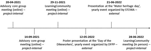
Against this background, the research project ‘RuiKwa-LAB’ (which in Dutch stands for ‘Ruimtelijke kwaliteit in waterveiligheidsbeheer’, and translates to English as ‘Spatial quality in Dutch flood risk management’) was established in 2021. RuiKwa-LAB is a 4-year cooperation between the Universities of Groningen and Wageningen and various Dutch regional water authorities, consultancies and knowledge institutes. In total, the consortium consists of 19 organizations. The goal is to provide concrete insights into how spatial quality can be integrated into flood risk management projects, from a planning and design perspective. To ensure continuous knowledge exchange between science and practice, a ‘Learning Community’ was formed with all involved partners which meets 1–2 times per year. Next to this Learning Community, the research team (including the authors of this paper) regularly seeks advice from the ‘advisory core group’ consisting of representatives from three water authorities and three consultancies who meet 3–4 times per year. The overview and critical reflection of policy instruments for spatial quality in the DFPP (see Section 5), is one of the products of this research collaboration. A three step-methodological approach was applied to rigorously manage this co-learning process between science and practice.
4. A three-step methodological approach for co-learning
Step 1: Initial exploration and collection of instruments
A first exploration and collection of policy instruments for spatial quality was based on three focus group meetings with the Learning Community-members and an analysis of policy documents. The focus group meetings were part of the project’s kick-off meeting in March 2021 (which was online due to COVID-restrictions). Representatives from 12 Dutch regional water authorities and three consultancy agencies participated. Participants were divided into three groups to ensure active discussions. They were asked to name all sorts of instruments they would use to incorporate spatial quality in flood risk management projects, which resulted in a collection of policy instruments using Google Jamboard and accompanying discussions about their experiences with these instruments. At this stage, the researchers had not yet introduced the NATO-typology, but instead encouraged the Learning Community-members to think broadly about the term ‘policy instrument’. That way, we aimed to get a better grasp on the professionals’ view on helpful tools without already steering into a particular direction.
This initial identification of policy instruments was further substantiated by an analysis of 11 guiding policy documents, which were either related directly to the DFPP or flood risk management in general and addressed spatial quality (see overview in Appendix). This first step of the research process enabled us to identify commonly suggested policy instruments for spatial quality, without yet further clustering these instruments.
Step 2: Bundling and categorization of instruments according to NATO-typology
In a second step, we interviewed members of the Learning Community (i.e. representatives from the involved Dutch regional water authorities and the DFPP) to get a better grip on the instruments (i.e. how frequently they are used and how wide-spread their application is). In total, 13 interviews were held; often multiple representatives of the organization were present (see ). Next to improving our understanding of the instruments and the DFPP context, the interviews were also intended to build rapport for the remainder of the project and understand how participants view the changing role of their organization from mainly technical towards more socio-spatially engaged water authorities. The interviews helped to group the instruments under one category and eliminate others which were too (context-)specific or less relevant. For instance, ‘landscape biographies’, ‘artist impressions’ and ‘visions on spatial quality’ became all part of the category spatial quality frameworks. The actual categorization of the instruments according to the NATO-typology involved several discussions among the research team and was further supported by existing literature on policy instruments for spatial quality in the Dutch Room for the River-programme (e.g. Busscher et al., Citation2019; Verweij et al., Citation2021).
Table 1. Overview of interviewees.
Step 3: Validation and fine-tuning of instruments overview
To validate and fine-tune the overview and classification of instruments according to the NATO-typology, we built several feedback moments into our research design where we presented our findings about the instrument palette to the Learning Community members and to other water authorities and water professionals. The goal of these internal and external feedback moments was to check with Dutch water professionals whether our overview of instruments was complete, and the classification logical. In total, we had six feedback moments between April 2021 and June 2022 (see ). We deliberately chose to focus on project-internal feedback moments first, and then gradually moved to external feedback sessions with a broader audience of water professionals. The internal feedback helped to fine-tune the categories – e.g. ‘hiring consultants’ was added to the palette. During the external events the content and classification of the instruments’ palette was not questioned, but rather evoked in-depth discussions about some of the instruments (e.g. the role of spatial designers).
Figure 1. Timeline of co-learning process and feedback moments.
5. Policy instruments for spatial quality in the Dutch Flood Protection Programme (DFPP)
The co-learning process between science and practice resulted in instruments palette for strengthening spatial quality in Dutch flood risk management (see ). In the remainder, the identified instruments will be explained in more detail, including a critical reflection on common standpoints, concerns and dilemmas related to the DFPP.
Figure 2. Instruments palette for spatial quality in the DFPP.
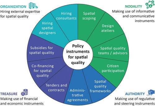
Organization: the need for a ‘spatial integrator’
In this study, the identified organization instruments relate particularly to the human resources of an organization. Many professionals call for the role of a ‘spatial integrator’ in the project team. At the ‘Day of the Dikeworkers’ (see ), one of the keynote speakers proposed that: ‘A spatial integrator in the project team leads to a gain of time, money and quality’, an opinion shared by many regional water authorities from our Learning Community. Although it is common practice to work with Integrated Project Management (IPM)-teamsFootnote2, many feel like the IPM-model is insufficient to safeguard spatial quality as none of the assigned roles necessarily possess any spatial planning or design skills. This kind of expertise is often lacking in regional water authorities, as interviewee (R6) explained: ‘Thinking in spatial planning, experience with spatial planning procedures, and participating in these procedures from an integral perspective, is something we strongly need, but do not naturally have within our organization’. Therefore, organization instruments identified in this study relate to hiring professionals with these skills.
First, it was argued that spatial designers – often landscape architects – can view the flood risk management problem in a broader spatial context. Their spatial design skills help in better understanding the spatial values of an area, generate assessment criteria for (technical) interventions, and evaluate designs against these criteria. Moreover, maps and drawings are strong visual tools to start discussions about complex matters and (co-)create alternative futures, which is why designers are increasingly also involved as process managers to improve communication with stakeholders (cf. Kempenaar & van den Brink, Citation2018; Nassauer, Citation2012; van den Brink et al., Citation2019). However, some interviewees believed that spatial quality should not be a ‘landscape architects’ domain alone’. As interviewee (R3) explained: ‘I think that spatial quality is something of everyone involved in a project, it is certainly something of the whole environment.’
Consultants were also mentioned as potential ‘integrators’, although less frequently than spatial designers. Compared to spatial designers they have a less clearly defined disciplinary background; their strength is that they have often worked in a variety of flood risk management projects, which has broadened their scope. Moreover, their organizations usually employ people from several disciplinary backgrounds, which can help in fostering an integrated approach. Also, consultancy firms are hired in almost every flood risk management project giving them the opportunity to put spatial quality onto the agenda. For example, consultants often play a significant role in choosing the preferred solution, as they advise on assessment criteria in which they can actively underline the importance of spatial quality (Conijn & Bijman-Van den Dungen, Citation2021). To what extent they do so, depends much on the individual consultant though – not every consultant has a strong affinity with spatial quality.
Overall, the need for a ‘spatial integrator’ very much resembles the concept of ‘boundary spanners’ – skilled networkers who can connect and build trust between different actors and organizations, and thereby enhance inter-organizational relationships (Edelenbos & van Meerkerk, Citation2015). During a Learning Community-day (June 2022), it became clear that spatial integrators often are spatial designers or landscape architects, as also pointed out by earlier research (van den Brink et al., Citation2019), but can also have different backgrounds. What matters more are certain personal characteristics such as good listening skills and the ability to connect, translate, ‘think spatially’ and ‘out of the box’. Translating these soft skills into transparent recruitment criteria is considered a challenge, though. Not every spatial designer, landscape architect or consultant naturally possesses these character traits. Conditions that are considered to be conducive for integrators are that they are involved throughout the course of the project, from early on, and that their position is recognized with a mandate, for instance an official place in the project team.
Nodality: balancing act between broad scope and efficiency
Nodality refers to the way in which regional water authorities interact with other stakeholders from the environment to make sense of spatial quality. In the DFPP, four types of nodality instruments were identified.
The first instrument is spatial scoping, which means that the water authority makes inquiries about other spatial challenges or plans in the (adjacent) area, for instance from municipalities, provinces or nature organizations. This involves both existing plans and plans that are still in the making. As also pointed out by Klijn et al. (Citation2013), such spatial scoping is particularly beneficial for spatial quality when carried out early in the project, because then possible policy synergies can be identified and acted upon. Spatial scoping might even be most effective when the project has not yet officially started, as it then also stimulates commitment among other relevant stakeholders. Interviewee (R2) suggested a pre-phase before the official start of the project, because:
Even parties interested in spatial quality, in the short time of the official exploration phase of a DFPP project, can hardly change their yearly budget to add to spatial quality. Also, they often think ‘well, it’s your project, so you take care of a good spatial fit’.
Another instrument applied by the water authorities are design ateliers, in which different stakeholders and multidisciplinary experts come together to collect, share, and co-create knowledge, using design as a tool. These ateliers are often organized by project teams in close collaboration with spatial designers or consultants. Ideally, design ateliers stimulate thinking beyond disciplines and help in making integral designs with multiple benefits (RWS-ontwerpt, Citation2020). Such ateliers are usually applied in rather complex projects, where several stakes are at play.
Third, water authorities can seek advice on spatial quality from specific spatial quality teams or from internal or external spatial quality advisors. Spatial quality teams are part of Dutch planning culture; they typically consist of 4-5 people, often with backgrounds in (landscape) architecture or cultural history, and consult – mostly municipal – governments on (urban) development issues (van Assen & van Campen, Citation2014). In the Room for the River-programme, a ‘Q-team’ was appointed by the National Government to advice projects on spatial quality and monitor their progress (Klijn et al., Citation2013). The DFPP does not have such a formal quality team in place, as spatial quality is less institutionalized (see Section 1). Nonetheless, a few regional water authorities mentioned that they have formed their own spatial quality teams. In one case the spatial quality team is a collaboration between the water authority and a foundation working on landscape management on the provincial level. Spatial quality advisors can work either internally at the water authority, or be employed externally at the National Office of Cultural Heritage, provinces, or municipalities. Although seeking advice from quality teams or advisors remains informative and not binding, an interviewee (R13) pointed out that ‘spatial quality teams can strengthen the role of spatial quality and spatial designers in the process’.
Lastly, citizen participation was an often-mentioned instrument related to spatial quality. Dutch regional water authorities are currently in a transition from technical-rational experts towards more responsive, democratic and ‘spatial’ organizations, in which close contact with their local environment – and hence citizen participation – is considered crucial (van den Brink & Restemeyer, Citation2021). Different levels of citizen participation were mentioned, ranging from formal hearings to rather informal resident gatherings (open events usually organized in community centres), ‘dike conversations’ (smaller group of residents invited to the concerning dike), ‘kitchen table talks’ (bilateral conversations taking place in people’s homes) and participation in design ateliers. Citizen participation is considered essential by most water authorities to better understand: citizen’s appreciation of, and desires for, the landscape; acquire local knowledge; build trust; and, gain support for specific flood risk management projects. Many interviewees, however, also felt that organizing intensive citizen participation goes beyond their key tasks and responsibilities (see also Mostert, Citation2017).
The application of these nodality instruments varies significantly among the water authorities and also depends on the complexity of the project. An often-heard dilemma was that most of these instruments are rather time-consuming, making it a delicate balancing act between applying a broad scope, with potential gains for spatial quality and democracy, and striving for efficiency.
Authority: rather soft than binding navigation devices
Authority-based instruments are tools in which the regional water authority, or another government authority, makes use of their regulatory powers to integrate spatial quality into flood risk management. Two instruments came to the fore during our analysis of the DFPP.
First, spatial quality frameworks, which can exist on multiple levels and scales. From our interviews and Learning Community-meetings, it became clear that the most common are project-specific spatial quality frameworks, made by landscape architects in the early phase of a flood risk management project, to better understand the history and landscape values of an area. It was argued that these frameworks can be helpful in making sense of spatial quality in the project-specific context. They often end with design principles for possible reinforcement solutions. Sometimes these design principles are then translated to specific ‘aesthetic programmes of requirements’ which are used to approach market parties and assess their proposed solutions in terms of spatial quality. Other examples are more generic spatial quality frameworks, either made by provinces on a broader regional scale (e.g. ‘Spatial Perspective on Dikes in Overijssel’ by BoschSlabbers (Citation2017)) or by regional water authorities themselves (e.g. ‘Blue Strategy on Spatial Planning and the Environment’ by Noorderzijlvest (Citation2021)). However, these generic spatial quality frameworks are rather rare and usually only have a guiding and not so much an obligatory character.
Second, administrative agreements can be used to outline the division of tasks, terms, and conditions between two or multiple parties. They are also called ‘collaboration agreements’. Often these agreements clarify responsibilities and help to formalize co-financing from other parties. How much they contribute to spatial quality also depends on if, and how, spatial quality is defined in these agreements; based on research about the Room for the River-programme, they are expected to be more successful when spatial quality is specified beyond the general notion (Busscher et al., Citation2019). While such agreements are meant to create commitment for spatial quality among multiple parties, living up to this ‘paper reality’ can be difficult, as one interviewee (R7) pointed out for a specific project:
We have an administrative agreement with ten parties who cooperate, but we as regional water authority are still officially in the lead. It remains challenging to keep everybody actively involved. Creating and keeping the feeling of ‘shared ownership’, for 12 years long, is quite a skill, especially in politically driven organisations.
In conclusion, both spatial quality frameworks and administrative agreements can be used to make more formal agreements on spatial quality, but they are still rather softer than binding navigation devices. This has of course much to do with the nature of spatial quality as an ambiguous policy objective, which makes it hard to embed it in more powerful rules and regulations. Therefore, their usage and effect depend much on individual project team members, their scrutiny and (existing) relationships with partners in the region.
Treasure: finding additional financial resources as sine qua non
Treasure instruments broadly relate to a regional water authority’s usage of financial and economic means. In the DFPP, three treasure instruments were identified.
First, water authorities can use tenders and contracts to secure spatial quality ambitions by making spatial quality an explicit criterion in these documents. Tender documents can for example specify spatial quality ambitions by setting out an ‘aesthetic programme of requirements’ (see Section 4.3), making spatial quality a formal assessment criterion. Previous research showed that different contract types can also affect the spatial quality (Verweij et al., Citation2021). Often more traditional contracts are used where the contractor only comes into the picture once the planning phase is completed. If not specified beforehand, spatial quality ambitions can then be compromised because of pressures on time and budget (Busscher et al., Citation2019). In more integrated and inclusive contracts – such as ‘Plan Design and Construct’-contracts – the contractor is already involved earlier. This can lead to potential benefits for efficiency and spatial quality, as expectations on spatial quality between contractor, water authority and other parties can be coordinated on time (Verweij et al., Citation2021).
The second and third instruments relate to finding additional money for realizing spatial quality. Interviewees mentioned acquiring co-funding as well as subsidies in this respect. Co-funding implies that other stakeholders contribute financially to the spatial quality ambitions of the project. Co-funding usually comes from other authorities, mostly provinces and municipalities, but sometimes also businesses, nature organizations or inhabitants contribute. In Limburg, for example, residents contributed to realize self-closing flood barriers, so that their usual view would not be compromised. Subsidies, on the other hand, usually come from European or national funds. Examples that were mentioned included funds from the European Water Framework Directive, innovation funds from the DFPP, or subsidies related to other national policy programmes (such as the ‘Programmatic Approach Great Waters’ – an investment programme targeted at improving water quality and strengthening nature in large Dutch waters).
Finding additional money is considered one of the biggest challenges by our Learning Community-members, because DFPP funds – stemming collectively from regional water authorities and National Government – may only be used for flood safety according to the motto ‘sober and efficient’ (see Section 3). A project receives funding for the water safety solution and ‘a good spatial fit’, which means that the spatial quality of the area may not decrease because of the project. When the project wants to improve the spatial quality of the environment, the additional costs for this improvement requires financing from other sources. What counts as ‘spatial fit’ and what counts as quality improvement of the environment, is often not immediately clear though. Arguments for a ‘spatial fit’ usually require compliance with a legal basis such as a municipal or provincial land-use plan. As these funding issues usually require much time during discussions with the DFPP supervision team, they have been described as ‘frustrating’. Water authorities wish for ‘less discussions’ and ‘more cooperation’ from the DFPP supervision team. However, interviewees indicated that they also understand the difficult situation of the DFPP concerning time delays and exceeding costs (see Section 3). The DFPP’s Advisor on Knowledge and Innovation (R19) speaks of an ‘intrinsic tension’ between the increased attention to spatial quality and the main goal of the DFPP to realize projects faster and cheaper. Overall, project teams need to be very persistent and persuasive, as finding additional financial resources can be considered as sine qua non for realizing spatial quality.
6. Discussion and conclusion
The aim of our research was to establish an instruments palette to strengthen spatial quality in flood risk management. The main theoretical contribution lies in making the NATO-framework specific for spatial quality and flood risk management, thereby offering a broad palette of instruments that can be used to reach (often) ambiguous policy objectives. As Stead (Citation2021) already argued, the NATO-framework – widely used in public policy studies – has been largely overlooked in spatial planning literature so far, and this is also true for flood risk management. The instrument palette helps in understanding which (sort of) instruments exist. The specific insights from the DFPP indicate how these instruments can be used and which dilemmas practitioners might encounter. Based on our empirical findings, we first elaborate on three key observations related to the instruments palette. Then we discuss the generalizability of the findings and indicate avenues for further research.
First, the organization category – absent in other typologies of instruments than NATO (such as Bemelmans-Videc et al., Citation1998; Mees et al., Citation2014) – proves to be rather important for achieving spatial quality in flood risk management. Considering the hiring of people as an instrument might at first sound bewildering, but in times where interdisciplinary work and policy integration are increasingly becoming a mandate, hiring expertise outside of the organization’s core skills can be absolutely necessary, and a means to achieve a certain policy goal. Previous research pointed already towards the importance of landscape architects as boundary spanners in this respect (e.g. van den Brink et al., Citation2022). Our research shows that also people with different disciplinary backgrounds can function as ‘spatial integrators’. In addition, often multiple boundary spanners, each having a specific role, contribute to achieving spatial quality in flood risk management projects. This is in line with previous research by for instance van Lente et al. (Citation2003) on the various roles of ‘systemic intermediaries’ (such as boundary spanners) in transition processes.
Second, the broad array of nodality instruments is proof of the ongoing transition towards more democratic and responsive regional water authorities (see also Mostert, Citation2017; van den Brink & Restemeyer, Citation2021). The traditionally ‘technical’ Dutch regional water authorities invest much in ‘democratic’ instruments such as citizen participation and design ateliers, as it also supports their ‘licence to operate’, but they also feel an intrinsic tension with their role as functional governments exclusively responsible for water management. This points towards an incomplete transition; further insights are needed how water authorities could reinvent their role and proactively participate as partner in integrated flood risk management projects.
Third, the current instruments palette is relatively light in terms of binding instruments, which relates to the ambiguous framing of spatial quality in the DFPP. Even the identified authority instruments are rather ‘soft’ than binding navigation devices. How much spatial quality frameworks and administrative agreements are used and brought to life, depends much on the scrutiny and commitment of specific project team members, their respective organizations and other project partners. In a similar vein, acquiring additional financial resources for spatial quality requires high perseverance and persuasion skills from project team members.
On a general level, although the insights are derived from the Dutch context, the instruments identified are rather generic and therefore may also support flood risk managers elsewhere to enhance the spatial turn in flood risk management. Because of their generic nature, the instruments can also be applied to strengthen spatial quality in other policy sectors that demand spatial transformations such as the energy transition, circular agriculture or sustainable mobility. Most of the dilemmas related to the use of these instruments in the DFPP come forth from the specific governance approach in this national policy programme where much of the responsibility for spatial quality is decentralized to the regional water authorities, leading to very different approaches per organization and even per project, making network-oriented governance crucial to achieving spatial quality. While spatial quality certainly asks for tailor-made approaches on local and regional levels, more formalized and centralized guidance and support would certainly help regional water authorities to commit more strongly to the spatial turn.
Concludingly, we suggest the following avenues for further research to substantiate the instruments palette. First, more research is needed on how specific instruments work out in practice, as well as which policy instrument mixes work best in which planning phase (from exploration, planning, realization, to management and maintenance). Second, examining cases from other policy sectors – in the Netherlands and internationally, preferably with varying governance approaches (e.g. more hierarchical or market-based) – can help to cross-check and expand the instruments palette, e.g. how to further develop authority and treasure instruments from rather soft towards more binding navigation devices. And third, longitudinal studies may enhance knowledge about e.g. how the use of instruments develops over time in policy programmes like the DFPP with changes in (national) political decisions and central programme steering.
Acknowledgements
We would like to thank all partners from the ‘RuiKwa-LAB’-Learning Community for their active engagement in our research - we could have not written this manuscript without their valuable insights. For more information about the research project and the participating partners in the Learning Community, please see the RuiKwa-LAB website: https://www.rug.nl/research/ursi/ruikwalab/.
Disclosure statement
No potential conflict of interest was reported by the authors.
Additional information
Funding
Notes
1 The Delta Works in the Netherlands, a series of dams, sluices, weirs and storm surge barriers, built between 1954 and 1997, brought the Dutch worldwide fame as ‘conqueror of the sea’.
2 IPM-teams consist of five roles: (1) principal project manager with ultimate responsibility for the project result; (2) stakeholder manager to consult with all relevant public and private stakeholders; (3) project controller to manage risks; (4) technical manager to ensure adequacy of content and technique; and (5) contract manager who manages contracts and contacts with market parties.
References
- Acciai, C., & Capano, G. (2021). Policy instruments at work: A meta-analysis of their applications. Public Administration, 99(1), 118–136. https://doi.org/10.1111/padm.12673
- AT Osborne. (2021). Ruimtelijke kwaliteit in wateropgaven – Een verkenning naar verbetermogelijkheden. https://open.overheid.nl/repository/ronl-556f0ac0-9420-44e0-95a8-e1be3fedeab8/1/pdf/bijlage-rapportage-verkenning-verbetermogelijkheden-ruimtelijke-kwaliteit-bij-wateropgaven.pdf
- Bemelmans-Videc, M. L., Rist, R. C., & Vedung, E. (1998). Carrots, sticks & sermons: Policy instruments and their evaluation. Transaction Publishers.
- Beven, K. J., & Hall, J. (2014). Applied uncertainty analysis for flood risk management. Imperial College Press.
- Bos, I. (2022). Stabiliteit HWBP-programm in het geding door vertragingen. https://www.waterforum.net/stabiliteit-hwbp-programma-in-het-gedingdoor-vertragingen/
- BoschSlabbers. (2017). Spatial perspective on dikes in Overijssel. https://vnrgemeenten.nl/wp-content/uploads/2019/05/Ruimtelijk-Perspectief-Dijken-Overijssel.pdf
- Busscher, T., van den Brink, M., & Verweij, S. (2019). Strategies for integrating water management and spatial planning: Organising for spatial quality in the Dutch ‘Room for the River’ program. Journal of Flood Risk Management, 12, e12448. https://doi.org/10.1111/jfr3.12448
- Conijn, A., & Bijman-Van den Dungen, S. (2021). Ingenieursbureaus versterken ruimtelijke kwaliteit. Land+Water, 5, 20–21.
- CRA, Board of Government Advisors. (2020). Dutch Flood Protection Programme – from ‘sober and effective’ to ‘smart and effective’. https://www.collegevanrijksadviseurs.nl/adviezen-publicaties/publicatie/2020/07/21/hoogwaterbeschermingsprogramma-van-sober-en-doelmatig-naar-slim-en-doelmatig
- Cropper, M., & Griffiths, C. (1994). The interaction of population growth and environmental quality. American Economic Review, 84(2), 250–254.
- Cumiskey, L., Priest, S. J., Klijn, F., & Juntti, M. (2019). A framework to assess integration in flood risk management: Implications for governance, policy, and practice. Ecology and Society, 24(4), https://doi.org/10.5751/ES-11298-240417
- Daniel, T. C. (2001). Whither scenic beauty? Visual landscape quality assessment in the 21st century. Landscape and Urban Planning, 54(1–4), 267–281. https://doi.org/10.1016/S0169-2046(01)00141-4
- Dauvellier. (1991). Ruimtelijke kwaliteit: de oorsprong en toepassing van een begrip. Rapporten Werkgroep Landelijk Gebied. NIROV.
- De Groot, T., & Bromet, L. (2020). Motion by parliamentary members de Groot and Bromet about combining spatial quality with the water challenge [Letter to Parlament]. https://www.tweedekamer.nl/kamerstukken/detail?id=2020Z23424&did=2020D49447
- DFPP. (2020). Dike workers continue to work [yearly report by the DFPP]. https://hoogwaterbescherming.foleon.com/jaarbericht/jaarbericht-2020/jaarbericht-2020/
- DFPP. (2021). Sustainability and spatial quality in the DFPP [monitoring report]. https://www.hwbp.nl/binaries/hoogwaterbeschermingsprogramma/documenten/rapporten/2021/03/16/index/Rapportage+monitoring+2020+Duurzaamheid+en+ruimtelijke+kwaliteit+def+%281%29.pdf
- Dieperink, C., Hegger, D. L. T., Bakker, M. H. N., Kundzewicz, Z. W., Green, C., & Driessen, P. P. J. (2016). Recurrent governance challenges in the implementation and alignment of flood risk management strategies: A review. Water Resources Management, 30(13), 4467–4481. https://doi.org/10.1007/s11269-016-1491-7
- Duijn, M., Vreugdenhil, H., Janssen, S., Tromp, E., & Ellen, G. J. (2021). Organising knowledge generation and dissemination in the Dutch high-water protection programme – A sender-receiver approach. Knowledge Management Research & Practice, 20(4), 606–618. https://doi.org/10.1080/14778238.2021.1886617
- Edelenbos, J., & van Meerkerk, I. (2015). Connective capacity in water governance practices: The meaning of trust and boundary spanning for integrated performance. Current Opinion in Environmental Sustainability, 12, 25–29. https://doi.org/10.1016/j.cosust.2014.08.009
- Healey, P. (2004). The treatment of space and place in the new strategic spatial planning in Europe. International Journal of Urban and Regional Research, 28(1), 45–67. https://doi.org/10.1111/j.0309-1317.2004.00502.x
- Healey, P. (2010). Making better places: The planning project in the twenty-first century. Macmillan Education UK.
- Hood, C. (1986). The tools of government. Chatham House Publishers.
- Hooimeijer, P., Kroon, H. J. J., & Luttik, J. (2001). Kwaliteit in meervoud (Issue June 2014). http://ruimtexmilieu.nl/uploads/documents/kwaliteit_in_meervoud (1).pdf
- Howlett, M., & Rayner, J. (2007). Design principles for policy mixes: Cohesion and coherence in ‘new governance arrangements’. Policy and Society, 26(4), 1–18. https://doi.org/10.1016/S1449-4035(07)70118-2
- Janssen-Jansen, L. B., Klijn, E. H., & Opdam, P. (2009). Ruimtelijke kwaliteit in gebiedsontwikkeling. Habiforum. http://www.habiforum.nl/upload/documents/20090804%20ESSAY%20RUIMTELIJKE%20KWALITEIT.pdf
- Kempenaar, A., & van den Brink, A. (2018). Regional designing: A strategic design approach in landscape architecture. Design Studies, 54, 80–95. https://doi.org/10.1016/j.destud.2017.10.006
- Klijn, F., de Bruin, D., de Hoog, M. C., Jansen, S., & Sijmons, D. F. (2013). Design quality of room-for-the-river measures in The Netherlands: Role and assessment of the quality team (Q-team). International Journal of River Basin Management, 11(3), 287–299. https://doi.org/10.1080/15715124.2013.811418
- Leendertse, W., Langbroek, M., Arts, J., & Nijhuis, A. (2016). Generating spatial quality through Co-creation: Experiences from the Blankenburgverbinding (The Netherlands). Transportation Research Procedia, 14, 402–411. https://doi.org/10.1016/j.trpro.2016.05.092
- Löschner, L. (2018). The spatial turn in flood risk management. A case study of Austria’s Changing Flood Policies [Doctoral Thesis]. https://www.wien.gv.at/umweltschutz/nachhaltigkeit/pdf/loeschner-2018.pdf
- Macintosh, A., Foerster, A., & McDonald, J. (2015). Policy design, spatial planning and climate change adaptation: A case study from Australia. Journal of Environmental Planning and Management, 58(8), 1432–1453. https://doi.org/10.1080/09640568.2014.930706
- Mees, H. L. P., Dijk, J., van Soest, D., Driessen, P. P. J., van Rijswick, M. H. F. M. W., & Runhaar, H. (2014). A method for the deliberate and deliberative selection of policy instrument mixes for climate change adaptation. Ecology and Society, 19(2).
- Morgan, M. H. (1914). Vitruvius: The ten books on architecture. Dover Publications.
- Mostert, E. (2017). Between arguments, interests and expertise: The institutional development of the Dutch water boards, 1953-present. Water History, 9(2), 129–146. https://doi.org/10.1007/s12685-016-0154-1
- Moulaert, F., Van Dyck, B., Khan, A. Z., & Schreurs, J. (2013). Building a meta-framework to ‘address’ spatial quality. International Planning Studies, 18(3–4), 389–409. https://doi.org/10.1080/13563475.2013.837137
- Nassauer, J. I. (2012). Landscape as medium and method for synthesis in urban ecological design. Landscape and Urban Planning, 106(3), 221–229. https://doi.org/10.1016/j.landurbplan.2012.03.014
- Noorderzijlvest. (2021). Blue Stratgey on Spatial Planning and the Environment. https://www.noorderzijlvest.nl/_flysystem/media/blauwe-omgevingsvisie-noorderzijlvest-december-2021.pdf
- Oukes, C., Leendertse, W., & Arts, J. (2022). Enhancing the use of flood resilient spatial planning in Dutch water management – A study of barriers and opportunities in practice. Planning Theory & Practice, 23(2), 212–232. https://doi.org/10.1080/14649357.2022.2034921
- Pattison, I., & Lane, S. N. (2012). The link between land-use management and fluvial flood risk. Progress in Physical Geography: Earth and Environment, 36(1), 72–92. https://doi.org/10.1177/0309133311425398
- Rhodes, R. A. W. (1996). The new governance: Governing without government. Political Studies, 44(4), 652–667. https://doi.org/10.1111/j.1467-9248.1996.tb01747.x
- Rijke, J., van Herk, S., Zevenbergen, C., & Ashley, R. (2012). Room for the river: Delivering integrated river basin management in The Netherlands. International Journal of River Basin Management, 10(4), 369–382. https://doi.org/10.1080/15715124.2012.739173
- RWS-ontwerpt. (2020). Integrale scopebepaling waterveiligheidsopgaven. https://www.hwbp.nl/documenten/rapporten/2021/03/08/integrale-scopebepaling-waterveiligheidsopgaven
- Sadowski, K. (2021). Implementation of the new European bauhaus principles as a context for teaching sustainable architecture. Sustainability (Switzerland), 13, 10715. https://doi.org/10.3390/su131910715
- Salamon, L. M. (Ed.). (2002). The tools of government : A guide to the new governance. Oxford University Press.
- Schaub, S., Vogeler, C., & Metz, F. (2022). Designing policy mixes for the sustainable management of water resources. Journal of Environmental Policy & Planning, 24(5), 463–471. https://doi.org/10.1080/1523908X.2022.2100751
- Stead, D. (2021). Conceptualizing the policy tools of spatial planning. Journal of Planning Literature, 36(3), 297–311. https://doi.org/10.1177/0885412221992283
- Sternberg, E. (2000). An integrative theory of urban design. Journal of the American Planning Association, 66(3), 265–278. https://doi.org/10.1080/01944360008976106
- Stöglehner, G. (2019). Conceptualising quality in spatial planning. Raumforschung und Raumordnung | Spatial Research and Planning, 77(1), 1–15. https://doi.org/10.2478/rara-2019-0002
- van Assen, S., & van Campen, J. (2014). Q-Factor – ruimtelijke kwaliteitsteams in nederland. blauwdruk.
- van den Brink, M., Edelenbos, J., van den Brink, A., Verweij, S., van Etteger, R., & Busscher, T. (2019). To draw or to cross the line? The landscape architect as boundary spanner in Dutch river management. Landscape and Urban Planning, 186, 13–23. https://doi.org/10.1016/j.landurbplan.2019.02.018
- van den Brink, M., & Restemeyer, B. (2021). Van waterschappen naar ‘klimaatschappen’? Kansen en belemmeringen voor strategische herpositionering in tijden van crisis. Bestuurskunde, 30(4), 41–51. https://doi.org/10.5553/Bk/092733872021030004005
- van den Brink, M., van den Brink, A., & Bruns, D. (2022). Boundary thinking in landscape architecture and boundary-spanning roles of landscape architects. Landscape Research, 1–13.
- van Lente, H., Hekkert, M., Smits, R., & van Waveren, B. (2003). Roles of systemic intermediaries in transition processes. International Journal of Innovation Management, 7(3), 247–279. https://doi.org/10.1142/S1363919603000817
- van Ruiten, L. J., & Hartmann, T. (2016). The spatial turn and the scenario approach in flood risk management—implementing the European floods directive in The Netherlands. AIMS Environmental Science, 3(4), 697–713. https://doi.org/10.3934/environsci.2016.4.697
- Verweij, S., Busscher, T., & van den Brink, M. (2021). Effective policy instrument mixes for implementing integrated flood risk management: An analysis of the ‘room for the river’ program. Environmental Science & Policy, 116, 204–212. https://doi.org/10.1016/j.envsci.2020.12.003
- White, I. (2010). Water and the city: Risk, resilience and planning for a sustainable future. Taylor & Francis.
- Wiering, M., & Immink, I. (2006). When water management meets spatial planning: A policy-arrangements perspective. Environment and Planning C: Government and Policy, 24(3), 423–438. https://doi.org/10.1068/c0417j
- Wiering, M., Liefferink, D., & Crabbé, A. (2018). Stability and change in flood risk governance: On path dependencies and change agents. Journal of Flood Risk Management, 11(3), 230–238. https://doi.org/10.1111/jfr3.12295