Abstract
Following the end of World War II the U.S. Army Map Service distributed maps captured from the German military to research libraries across the United States, where they have remained largely hidden collections. One focus of the University of California Berkeley’s German World War II captured maps digitization project has been the creation of detailed metadata for the German military map series. Data-rich catalog records with information about source maps and the need to do authority work for related corporate bodies provided entry points for exploring issues of provenance. The topographic map series that make up the bulk of this collection reflect the fragmentary nature of German cartographic history, with varying contributing corporate bodies, diverse source material, and a range of sophistication and technique. All of these characteristics evolved between 1936 and 1945 when the Nazi regime ramped up production of military maps. The authors make the case that it is worth the time and effort for libraries to invest in creating rich bibliographic descriptions for these map series.
Introduction
Hidden Collections
When it was established in 1917, the University of California (UC) Berkeley Library’s map collection consisted of only around 20,000 maps (Dowd Citation1961). As UC Berkeley map librarian Sheila Dowd reported, by 1961 the map collection had “quadrupled in size, the period of greatest growth coming after World War II when the Army Map Service made the University Library a depository for its own publications and its ‘distribution of captured maps’ program” (1961, 13). Between 1941 and 1968, the U.S. Army Map Service (AMS) was the military mapping agency of the United States. It was responsible for the production, publication, and distribution of topographic maps for use by the U.S. military (U.S. Army Citation1968). The AMS captured maps program redistributed maps captured by the U.S. military at the end of World War II, with the majority coming from German sources.
In the years leading up to World War II and during the actual war years, the German military amassed an enormous collection of cartographic materials. It prolifically published map series, initially for military contingency mapping, but ultimately for use in planning and carrying out a war for territorial expansion and subjugation. American military and intelligence forces captured many tons of cartographic materials toward the end of the war. Later they distributed many of these maps to research libraries, along with maps obtained from other enemy militaries. Yet despite their value in building the cartographic collection and as important historical documents, until the last few years UC Berkeley’s German captured maps have remained a hidden collection.Footnote1
UC Berkeley’s experience is not unique. Holdings of captured World War II military maps have largely remained a footnote in discussions of the AMS depository program (Dowd Citation1961; Hagen Citation1979). Libraries have typically either interfiled the captured maps amongst other map sets, a practice commonly used at the U.S. Geological Survey (USGS) Library (Hadden Citation2008) and also at UC Berkeley, or left them virtually untouched in storage areas, as was done at the University of Tennessee and the University of California, Riverside. For captured World War II maps, bare-bones catalog records, the inability to find the resources to provide quality access, and language barriers, have meant that, as Tatham remarked over forty years ago on the situation, “Despite all this inherent interest, and the value of these maps, they represent a resource that is grossly under-used (1978, 27).” This remains true today, even as recent scholarship and library digitization projects have brought more attention to the captured Japanese Gaihozu maps and Soviet maps (Quill and Dalmau Citation2019).
The historical significance of the German map series emerges more clearly when they are examined in a broader context. What follows is an inquiry into their provenance which accounts for the complex story of how the German maps were compiled and produced, acquired, and distributed to the research libraries which own them today. What is the historical significance of these maps? What corporate bodies were involved in their production and what roles did they play? Where does the source map data come from? How can we create metadata that adequately describes them and reflects their historical significance?
Merriam-Webster (Citation2021) defines provenance as “1: Origin, source; 2: the history of ownership of a valued object of art or literature.” In considering provenance broadly and investigating both the origins of the context in which a map series came together and the source materials upon which the cartographers relied, we can expand our understanding of the map series. These captured map collections have for various historical reasons been under-cataloged and under-used. As librarians begin to shine a light on these hidden collections through upgraded cataloging efforts and digitization, more of their secrets will be revealed. Provenance is the major thread to follow.
The Significance of the German Captured Maps
German military topographic map series represent the bulk of UC Berkeley’s German World War II captured maps. A few sets were issued by the civilian Reichsamt für Landesaufnahme or one of its surveying sections, but the majority were issued between 1936 and 1945 by the German military mapping organization which was administratively subordinated to the Army General Staff. Other German military mapping organizations, subordinated to the air force, navy, military intelligence, and Waffen-SS, also issued maps, but maps produced by these bodies are not well represented in UC Berkeley’s collection (CIA (Central Intelligence Agency) Citation1951).Footnote2 These German maps are important historical source materials. World War II was a watershed event that generated tremendous social, cultural, and political change around the globe. In many ways the war unmade an older world that was fundamentally transformed, swept away by upheaval and violence. These maps document what once existed, towns and villages that have been eradicated, place names that have been changed, political boundaries that have been redrawn. Also due to the widespread destruction in Europe during World War II and the torching of many cultural institutions, some of these maps are unique, the only surviving example of small print runs of a few hundred sheets. The captured map collections contain information that cannot be found elsewhere, but that is key to the work of historians, genealogists, and many other researchers.
The maps document the many crimes of the Nazi regime. These maps served as planning tools for a war to aggressively conquer and maintain control over vast territories. Some of the maps functioned as resource inventories which enabled German leaders to strategically extract resources from, exploit, and administer occupied countries and regions. The Nazis used census maps to uproot people from their homes and to plan the murder of countless others, foremost in the Holocaust (Müller and Hubrich Citation2009; Neumann Citation2015).
Historians of science and technology find value in the German captured maps as primary source materials. The German mapping agencies that produced these map series were important innovators in the use of photogrammetry, spearheaded the use of teams of military geologists, made pioneering use of military grids, and worked to integrate larger physical spaces through forward-looking geodetic work.
World War II was a turning point. The German captured maps help us to better understand the world that once existed, the world we have lost. The maps are not only evidence of what happened 75 years ago but also re-affirm the fact that these events are worth remembering. That includes the many crimes of the Nazi regime, and foremost the Holocaust.
A Brief History of German Mapping and Captured Maps
In many ways the story of the German World War II captured maps highlights the complexity and fragmentary nature of German history. The German word Kleinstaaterei has come to denote the territorial fragmentation of Germany. Local worlds were the focus of political activity, and mapping was long a local endeavor. That is reflected in the complicated histories of the German map series and the corporate bodies which issued them.
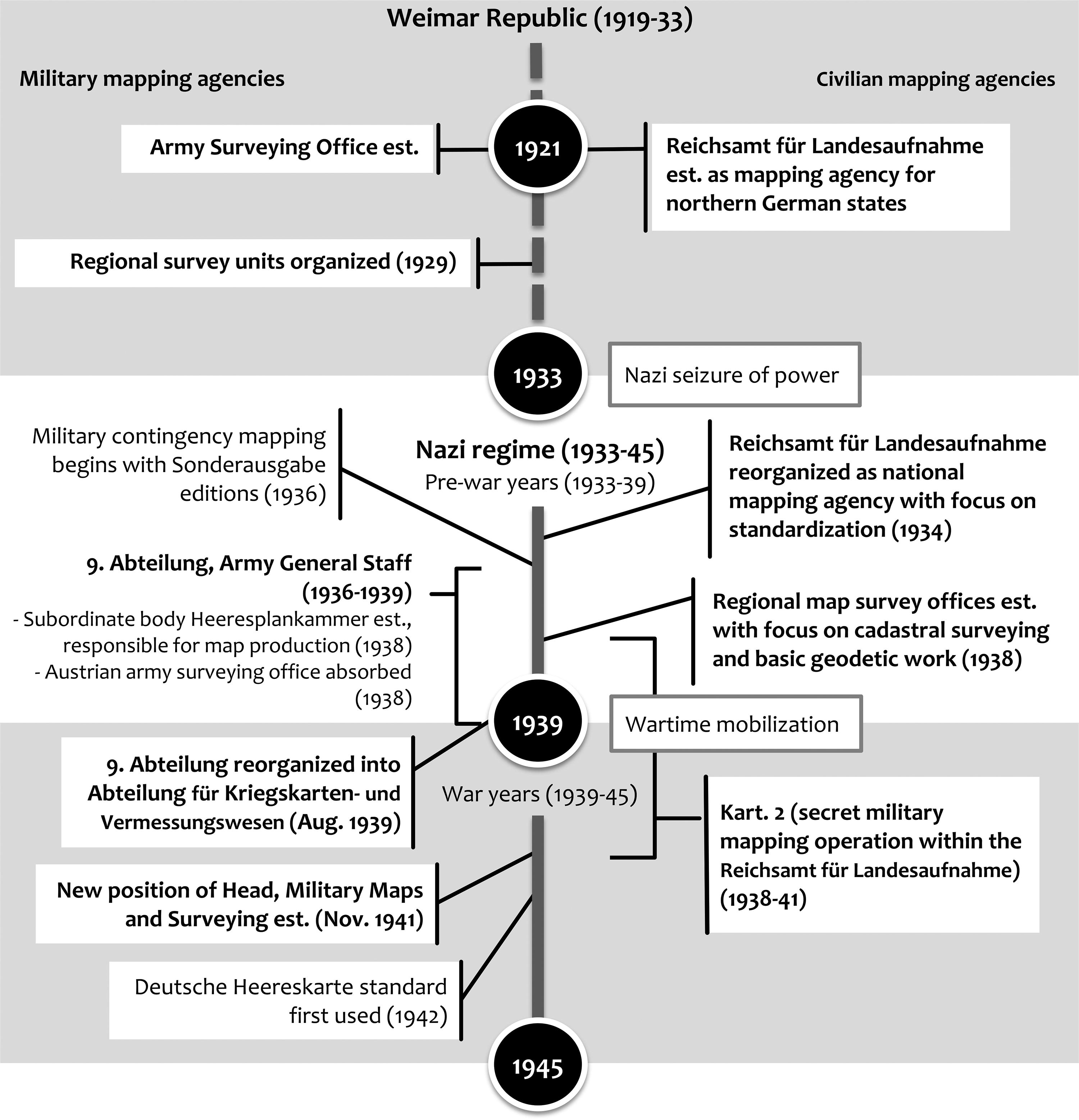
Eventually, a German nation state emerged in 1871, but the federal structure of the German Empire (1871–1918) and the Weimar Republic (1919–1933) preserved much of the historical complexity and hampered efforts to centralize and standardize German military and civilian mapping efforts. Although the bulk of UC Berkeley’s German World War II Captured Maps Collection consists of materials published in the 1930s and the first half of the 1940s, it also includes maps published as early as the 1870s. Many different state agency names appear on older sheets as cartographers or issuing bodies. That complexity came to an end with the Nazi seizure of power as the new regime centralized governmental functions.Footnote3 The state bodies which had published and issued maps ceased to exist. The Nazi regime wielded that same power to impose uniform national mapping standards and to homogenize the varied surveying and mapping practices of the German states (see Appendix A for a timeline of major events in the history of German mapping agencies from 1921 to 1945).
The sections below begin by providing a brief overview of this complex history. They also outline how German military maps were captured and amassed by American forces as fighting in the European theater of World War II came to a close. Ultimately these maps were distributed out to various academic, governmental, and public libraries in the years and decades afterwards.
The Institutional History of German Military Mapping
The original German topographic surveys were by-and-large military projects carried out by individual states. Consider, for example, the case of Prussia, the largest German state and one with a long state mapping tradition. In 1815, Prussia transferred all geodetic and cartographic tasks to the Prussian General Staff. Recording sheets were initially subject to military control. However, these detailed topographic maps gradually became more important as planning documents for economic and administrative matters. Around 1865, the Prussian military conceded to civilian pressures and began publishing topographic sheets at a scale of 1:25,000. Prussia established a military mapping agency in 1875, the Preußische Landesaufnahme [= Prussian Land Survey], which united sections of the General Staff engaged with surveying, triangulation, and mapmaking duties (see Appendix B for a list of translations of German-language terms and corporate bodies). All were subordinated to a single commanding officer (Albrecht Citation1969, Citation2004).
In July 1921, a reorganized Preußische Landesaufnahme, renamed as the Reichsamt für Landesaufnahme [= Land Survey Office], emerged from the chaotic German post-World War I transition. The new Landesaufnahme was a civilian body, administratively subordinated to the Weimar Republic’s Reich Ministry of the Interior. The Saxon Topographic Bureau, the mapping agency of the German state of Saxony, merged into this new institution that had been envisioned as a national mapping agency. But resistance from southern German states meant that in practice the Landesaufnahme functioned as the central surveying authority for northern Germany. Budgetary constraints and staffing reductions hampered the effectiveness of the institution (Lang Citation2008).
Following the Nazi seizure of power, the Reichsamt für Landesaufnahme served as a true national mapping agency from 1934 to 1945. Staffing expanded and the Landesaufnahme added new responsibilities in fields such as cadastral surveying. Fourteen regional surveying offices were established in 1938. The Landesaufnahme had always played a central role in the administration of surveying networks. This role expanded first into the southern German states, then into territories annexed to Nazi Germany, including Austria and the Czech lands. Eventually, this work expanded into areas conquered by Nazi Germany during World War II. Critical to integrating these vast spaces was geodetic work. Landesaufnahme staff made important contributions to basic geodetic research during work on projects to integrate and standardize Central European surveying networks. These projects would later be of great interest to American geodesists and provided the foundation for the geodetic reference system ED50, also identified as the European Datum 1950 (Torge Citation2007; Lang Citation2008).
Numerical restrictions on military personnel imposed on the German military by the Treaty of Versailles (1919) meant that military cartography largely halted in Germany in the 1920s and early 1930s. Mapping issues of concern to the German military therefore took a backseat. The military, once in charge of the Preuβische Landesaufnahme, now had to rely on advisory bodies to promote projects it deemed essential. A small Army Surveying Office was set up in 1921 and eight years later regional surveying units were established in all German military districts. As the Nazis consolidated power and military conscription was re-introduced in 1935, the military started to offer training courses and military surveying exercises to facilitate the wartime mobilization of mapmakers, civil engineers, surveyors, and cadastral officials (Müller and Hubrich Citation2009).
In 1936, Colonel Gerlach Hemmerich (1879–1969), a career army officer and military geodesist, was appointed head of the newly organized 9. Abteilung, Generalstab des Heeres (GdH) [= 9th Department, Army Surveying and Military Geography, of the Army General Staff], responsible for military mapping, surveying, and geographical analysis. Two military officers and 20 civilian employees of the Army Surveying Office and Section for Military Geography were initially assigned to this new command. After 1918, the German military had not engaged in military contingency mapping of foreign territory, so this was an urgent task for Hemmerich. He envisioned and constructed the military mapping machine that achieved this goal and eventually produced the maps that sustained the Nazi war effort. The centerpiece of Hemmerich’s efforts was the Heeresplankammer [= Army Planning Chamber], a subordinate body established in 1938 that oversaw the actual technical production of the German military maps. Over the next few years, he built up an efficient specialist service with a wide variety of offices and units. At its peak, during World War II, about 15,000 men served under his command. Almost all of these soldiers, including the professional staff, were civilians drafted into the military at the beginning of the war (Kneissl Citation1969; Müller and Hubrich Citation2009).
On August 26, 1939, following the war mobilization plans of the German army, the 9. Abteilung, GdH reorganized itself. During World War II it would be known as Abteilung für Kriegskarten- und Vermessungswesen [= Directorate for War Maps and Surveying]. In June 1941 Hemmerich’s command was directly subordinated to the Chief of the General Staff. A subsequent reorganization created the position of Chef, Kriegskarten- und Vermessungswesen [= Head, Military Maps and Surveying] with disciplinary powers comparable to those of a division commander. Hemmerich, now promoted to Lieutenant General, served in this role and simultaneously as commander of the Directorate for War Maps and Surveying (Müller and Hubrich Citation2009).
Compilation and Production
The German military maps held in captured World War II collections in American research libraries represent a wide variety of scales, cartographic styles, geographic areas, and source material languages (Tatham Citation1978). In part, this is a result of how the German military acquired foreign maps and map data, but it also reflects the state of German cartography before the war. A U.S. government research report describing and translating German mapping regulations between 1934 and 1944 recounts an overdue German effort to centralize and standardize mapping. Monmonier (Citation2005, 2) summarized, “Despite noteworthy advances in instrumentation and technique during the nineteenth century, German cartography in the early 1930s was distinguished by a diversity of products and procedures.” The emergence of the Reichsamt für Landesaufnahme as Germany’s first truly national mapping agency was an important initial step to remedy these deficiencies. Standardization efforts in surveying and heavy investment in basic geodetic work in subsequent years were additional steps that ultimately yielded positive results.
The German army used various tactics to build and refine its mapping program in the years between 1936 and 1945. In the early stages of Hemmerich’s tenure, the German military underwrote a major effort to acquire up-to-date foreign cartographic information through the map trade. They built a large map collection consisting chiefly of foreign topographic map series: they acquired entire sets and carefully tracked updates to sheets. Later, map collections and the offices of mapping agencies in occupied territories were systematically searched. Anything of potential value—documents, maps, geodetic data, and specialized equipment—was secured and analyzed. Some materials were removed and brought to Germany, but the primary goal of the German military was to integrate these foreign facilities and their resources into its system. In annexed and occupied territories, German military cartography and surveying units took over mapping agencies and map production facilities. This first happened in Vienna in 1938 where German civilian and military mapping agencies gained access to important resources and also knowledgeable highly skilled staff. Many of these sites became important nodes in the German military mapping and surveying operation. Gradually a system of German regional Kriegskarten- und Vermessungsämter [= War Maps and Surveying Departments] and map warehouse facilities emerged and covered much of Europe (Müller and Hubrich Citation2009; Neumann Citation2015).
The Heeresplankammer was the institution at the heart of the German military map production effort, but it initially lacked facilities and staff. Hemmerich thus relied on the cooperation of the civilian Reichsamt für Landesaufnahme to ramp up military map production. Its cartography department (Kartographische Abteilung) was subdivided into two sections, Kart. 1 and Kart. 2. Under the cloak of secrecy, beginning in 1938 the staff of Kart. 2 was assigned to work on “special projects” on the production of maps for areas outside German territory. This mapping was done as part of military contingency planning, a standard feature of military cartography operations in many countries (Cruickshank Citation2005).
The output grew steadily in the years 1938 and 1939, as an increasing number of print runs of military map series rolled off the printing presses. These maps were identified as Sonderausgabe [= Special Edition]. All staff designated to work on Sonderausgabe sheets came from the Cartography Department; no staff members with triangulation and compilation skills were assigned to Kart. 2. Staff with these skills were in short supply, engaged in civilian Landesaufnahme projects. Cruickshank (Citation2005) describes how this had a profound effect: most Sonderausgabe sets initially were well-made copies of the source maps, a reflection of the good reproduction and printing skills of Kart. 2 staff. But the lack of computational and compilational skills in Kart. 2 meant that newly derived maps incorporating additional material were rarely produced. Military grid information was also lacking on many Sonderausgabe sheets. Original trigonometrical data was unavailable.
Eggers, a cartographer assigned to work in the Heeresplankammer during World War II, describes the production processes in some detail (1974). Most Sonderausgabe sets were reprints with minor revisions. These minor revisions included resizing maps, making scale adjustments, and partially changing the color scheme. Other revisions were done to make it easier for the German-speaking troops to use the maps: adding German-language information to the map margin, inserting a bilingual legend (and sometimes a glossary), and translating into German any references to the landscape and names of important objects. Cartographic data updates, if they happened at all, were limited to border sheets. More significant revisions of the original maps took place when source map data was seen as inadequate. In that case, information from other cartographic data sets was added, for example, land cover data and contour lines. This was done for almost all sheets of the International Map of the World, 1:1,000,000, and other map series with a smaller scale. For essential projects, some map sheets were completely redrawn, if sufficient data was available and staff time was allocated. Eggers (Citation1974) cites some examples where this was done, the military map series Westliches Osteuropa, 1:300,000, and the sets which cover North Africa, 1:200,000.
Colonel Theo Müller, a German army officer who had served under Hemmerich’s command as a military surveyor and cartographer, provides insights into the production and publication process. Müller explains the introduction of the new Deutsche Heereskarte [= German Army Map] standard, starting in about 1942. These were maps with detailed military grids which could be used to direct artillery fire. The sheets had generally been updated, often with aerial photography and field checks. Scharfe (Citation2003) reports that other cartographic data was frequently added, for example, information from road maps for purposes of road classification. The same author discusses the complex production and publication history of a single German military map series, Spanien 1:50,000, for which a large number of sheets were produced in two editions between 1941 and 1944. As a result of an undercover intelligence operation, the German military was able to acquire Spanish military grid data for its own sheets before that data appeared on Spanish maps.
Gradually more editions of German map series were published with the Deutsches Heeresgitter [= German Army Grid], also sometimes identified as Europäisches Einheitsgitter [= European standard grid], which was based on the Gauß-Krüger coordinate system, with meridians six degrees apart for the zones (Lang Citation2008). Additional features appeared, for example, the Heeresmeldenetz [= Army Messaging Web], a grid used to locate observations and pass them up the chain of command. It was overprinted in orange on some sheets (). Similarly, new standard design features appeared on the map margin like the Ballenbezeichnung diagram that bundled key data. Many of these sets represent a leap forward in quality: Swiss cartographic historians have studied one of them, the Deutsche Heereskarte Schweiz 1:25,000, which mapped Switzerland in 254 sheets. They found that this German set was the basis for the Army Map Service’s military map series Switzerland 1:25,000, AMS series M895 (GSGS 4732), which was published by the U.S. military beginning in 1952 (Oehrli and Rickenbacher Citation2014).
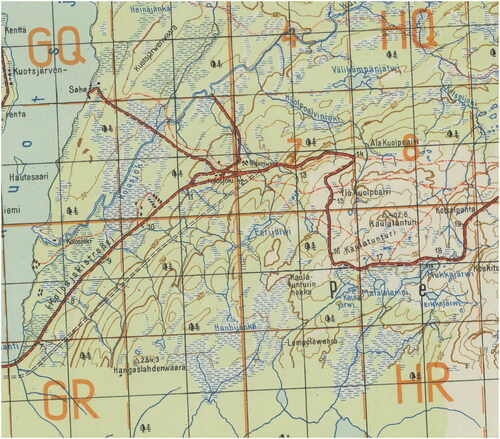
Figure 1. Inset of the Kolosjoki quadrangle (Norwegen/Finnland 1:50,000 sheet R36-10-W7) with 2 German military grids, Deutsches Heeresgitter, and Heeresmeldenetz overprinted in orange. Shows “Nickelwerk,” a mine where nickel, a rare metal used as steel hardener, was extracted. The nickel deposits of northern Finland were important to the German war effort in World War II. This sheet was produced in October 1943.
In summary, the map sets published by the German military between 1936 and 1945 differ a great deal and include varying levels of revision. Initial production consisted primarily of reprints and minimally revised editions that drew on the vast collections of maps amassed by the German military. Throughout the war, however, the Directorate for War Maps and Surveying and the mapping and surveying units under Hemmerich’s command increased their capacity for creating updated mapping using aerial photography and field checks (Anderson Citation2001; Scharfe Citation2003; Tatham Citation1978). They also steadily revised and standardized their base maps, leading to greater consistency and accuracy.
Capture
Floyd W. Hough (1898–1976), an American surveyor and geodesist, served in the U.S. Army Corps of Engineers during World War II. Hough was appointed a U.S. Army Major and was the leader of HOUGHTEAM, a special unit of the military intelligence division, Office of the Chief of Engineers. This secret U.S. Army military intelligence unit operated in the European Theater of Operations from October 1944 to September 1945. It successfully gathered more than 200 tons of German maps, geodetic data, and scientific instrumentation. Many of these resources were acquired during the last stages of World War II in Europe, as the U.S. Army invaded Germany and occupied German cities with large map collections. Other parts of the materials HOUGHTEAM collected were gathered in the immediate aftermath of the war in Europe, after the surrender of the Nazi regime had already taken place (Miller Citation2019).
Aachen, Germany, close to the border with Belgium, was the first large German city occupied by the U.S. military. When Aachen’s leaders surrendered on October 21, 1944, more than 70% of the buildings of the local college of applied sciences, the Technische Hochschule Aachen, had been either destroyed or were severely damaged (Klinkenberg Citation1970). But HOUGHTEAM successfully located important sets of geodetic data and a large treasure trove of German maps in the collections of the college’s Department of Geography (Miller Citation2019). This was just the first of many such opportunities. As German cities fell in quick succession in 1945, map collections in many German cultural institutions were visited by American military units.
Miller (Citation2019) notes that HOUGHTEAM spent considerable time searching map collections in Rhineland cities. Institutional ownership stamps in UC Berkeley’s German captured maps collection document that effort: a large number of sheets of the German map series Topographische Karte 1:25,000 (4 cm-Karte) in UC Berkeley’s collection have ownership stamps of the Geography Department of the University of Cologne. About half a dozen additional sheets came from a high school library in a nearby town, Bad Honnef.
German authorities evacuated people, factories, and cultural resources from urban areas when the Allied air forces began to gain the upper hand in the air war and systematically bombed German cities. A massive exodus relocated people and resources into the German countryside, primarily to areas in central and southern Germany. Art, books, document collections, and also maps and map data, including Nazi loot from occupied territories, were stored in warehouses, but also in underground mines. One of the largest troves of maps, a very significant collection of geological maps, was later discovered in a salt mine near Heringen, in eastern Hesse, near the boundary to Thuringia (Hadden Citation2008; Willig Citation2009).
The civilian German national mapping agency, the Reichsamt für Landesaufnahme, likewise, had evacuated its collections from Berlin to protect them from Allied air raids. The president, the central administration department, and the trigonometrical department ended up in Friedrichroda (Thuringia). The cartography department was split up, with the largest part moved to nearby Waltershausen (Thuringia). A substantial collection was stored in Jílové, Czech Republic, identified in German documents by its German name Eulau. Smaller parts were moved to Greiz (Thuringia) and Heidenau (Saxony). Resources associated with the Heeresplankammer, and therefore with the German military mapping operation, ended up in Greiz (Thuringia), Staßfurt (Saxony-Anhalt), and also in Saalfeld (Thuringia) (Böhme Citation1978).
This was the treasure trove of cartographic materials and geodetic data which American military planners had been looking for. A T-Force unit, part of a joint U.S. Army-British Army program to secure key German technology assets, was the first Allied mission to move into Thuringia to seize cartographic resources. The program, overseen by the Combined Intelligence Objectives Subcommittee (CIOS), had been designed specifically to loot defeated Germany’s intellectual assets and prevent them from falling into Soviet hands. John Gimbel, an American historian who wrote extensively about the U.S. occupation of Germany studied this effort and characterized it as “intellectual reparations,” a comprehensive and systematic program of extracting German scientific and technical know-how (Gimbel Citation1990; Peiss Citation2020).
U.S. troops occupied parts of Thuringia during the last weeks of fighting in Germany. But the U.S. military would have to ultimately vacate the area, due to decisions made by the Allied leaders at the conferences of Yalta and Potsdam. The area would be transferred under Soviet control. Later it was located within the boundaries of the Soviet occupation zone in Germany and ended up on the other side of the Iron Curtain, in Communist-controlled East Germany. Time was therefore of the essence. Important targets were scientists working for the Carl Zeiss Optical Works in Jena (Thuringia), which was the world’s premier manufacturer of instruments for surveying and geodetic work (Gimbel Citation1990).
The focus of “Wild Bill” Donovan, director of the Office of Strategic Service (OSS), initially was Germany’s foremost cartographic publisher, Justus Perthes, likewise located in Thuringia. On April 4, 1945, Donovan sent out a directive (T-Force #17554), using his OSS codename: “109 directs that contents of the firm Justus-Perthes (at Gotha, Germany), the largest map firm in the world, be obtained by OSS” (quoted in Crampton Citation2011). A team was ordered to Gotha immediately. Ultimately, nine tons of materials were removed and shipped to OSS facilities in Washington, D.C. (Wilson Citation1949; Crampton Citation2011).
Miller (Citation2019) describes HOUGHTEAM’s discovery of the collections of maps and geodetic data in Thuringia, collections associated with the German military mapping in the war but also collections that historically belonged to the Landesaufnahme. Americans had access to most of these sites until the end of June 1945. A large part of these collections was moved to Bamberg, Bavaria, located within the American occupation zone. There they were sorted and 90 tons of materials were ultimately shipped to the United States.
The Institute for Geodetic Work in Bamberg and later the Land Survey Office in Frankfurt employed Landesaufnahme staff under American auspices. These institutions became important institutional building blocks for a new West German national mapping agency, the Institut für angewandte Geodesie [= Institute for Applied Geodesy], which was established in Frankfurt in 1953. German federalism reasserted itself in West Germany, a clear division of labor emerged between the national mapping agency and the Land Survey Departments of the German states. In 1967, large shipments of cartographic resources arrived in Frankfurt. After negotiations, the U.S. government had agreed to return some cartographic resources which had been part of historical collections of the Reichsamt für Landesaufnahme (Böhme 1978).
Distribution
In 1945, AMS began distributing map sheets of the sets it was producing to participating depository libraries, including both academic and public institutions. Details are documented in surviving correspondence between Oregon State University and AMS from 1944 to 1947 (“OSU/AMS Correspondence, 1944–1947”). An AMS circular dated November 15, 1945, to its depository libraries, announced the availability of captured World War II and the AMS’s intention to distribute them. Along with this announcement, the AMS requested that libraries indicate their interest in receiving captured maps, and “any particular area or areas in which you consider you have a primary interest.” Some subset of depository libraries expressed interest in receiving captured maps in addition to the other map sets distributed by the AMS and, as can be seen from the Oregon State correspondence, some libraries also followed up with their geographic areas of interest. In the end, 35 U.S. research libraries received captured maps through the AMS depository program, as documented in a list provided by C.V. Ruzek, Jr. of the AMS in a February 27, 1950 memo to depository libraries. (For transcriptions of this correspondence, see Julie Sweetkind-Singer and Greg March, “Acquisition of World War II Captured Maps: A Case Study,” included in this issue).
While it seems clear that most captured maps were distributed through the AMS depository program, there is also evidence that some were distributed through other mechanisms. For example, the captured geological maps comprising the Heringen Collection at the USGS Library were gifted through a separate program. As Hadden (Citation2008, 260) describes, “Many of the captured Heringen maps were donated by the AMS to the Library of Congress and to other Federal Government agencies.” It is also probable that the Library of Congress distributed some captured maps through their summer program. (For description of Library of Congress summer project, see Paige Andrew, et al. “‘Will Work for Maps’: A History of the Library of Congress Geography and Map Division Special Map Processing Project,” included in this issue). Other World War II-era maps have been documented to be distributed in that way, for example, the Russian maps acquired by Dan Seldin for Indiana University, Bloomington (Quill and Dalmau Citation2019).
Overview of UC Berkeley’s Project
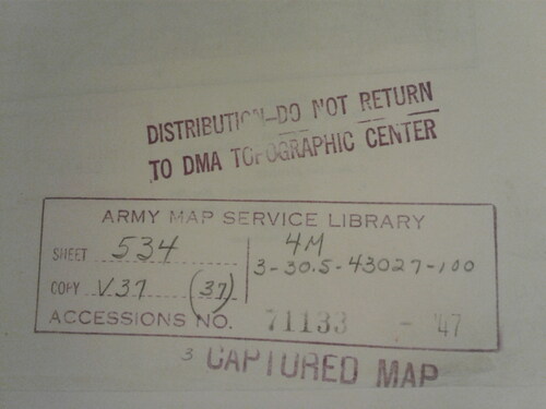
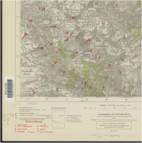
UC Berkeley Library’s German captured maps were acquired through the AMS depository program in the late 1940s and 1950s (Ruzek Citation1950; Dowd Citation1961), which is confirmed by two pieces of evidence. First, correspondence preserved in the UC Berkeley Library archives from UC Berkeley librarian Donald Coney to W.D. Milne, Colonel, Corps of Engineers of the AMS on December 26, 1945, confirms UC Berkeley’s interest in receiving captured maps (Coney Citation1945). Second, a list distributed in 1950 of 35 public and university libraries receiving captured maps through the AMS Depository Program includes the “Social Sciences Reference Service, [University of California Berkeley]” (Ruzek Citation1950). Many of the captured maps in UC Berkeley’s collection have AMS ownership stamps, chiefly from the late 1940s and early 1950s (), some of which reference the Omaha processing facility operated by the AMS. The UC Berkeley Library likewise inventoried the German captured maps it received using a date stamp. Acquisition stamp dates cluster in the mid-1950s. Phil Hoehn, who worked in UC Berkeley Library’s map collection beginning in 1980, recalled that the German captured maps were already minimally cataloged and integrated into the collection before he arrived at UC Berkeley (Hoehn, video call with authors, November 20, 2020).
Figure 2. An AMS processing stamp that includes such information as the date of the map, the AMS accessions number and date, and a note that is a “captured map.”
UC Berkeley Library staff handled the German captured maps they received like other maps obtained through the AMS depository program: no mention was made of their provenance in the catalog records. They were interfiled with map series of the same scale and geographic coverage for ease of use. Over time, many of these map sets were stored at the regional offsite shelving facility, the Northern Regional Library Facility (NRLF). These decisions made sense at the time for efficiency of processing and usability, but contributed to the “hidden collection” character of the German captured maps. Consequently, even though nearly all maps at UC Berkeley are cataloged, it has not been a simple task to identify the German World War II captured maps held by the UC Berkeley Library.
The project to identify UC Berkeley’s holdings was sparked in part by a discussion with UC Riverside. In 2017, the UC Riverside Library was taking steps to renovate its map and GIS space, which necessitated the withdrawal or re-location of a significant portion of its physical map collection (Reyes Citation2020). The UC Riverside GIS Librarian approached the GIS & Map Librarian at UC Berkeley with a proposal to transfer UC Riverside Library’s World War II captured map collections—both German and Japanese—to the UC Berkeley Library. Since UC Riverside never interfiled its captured maps collections, it could easily identify the maps that comprised the collection. The UC Riverside German captured maps include an estimated 13,888 sheets in total. A significant portion (6,300, or 45%) of the maps are unclassified, i.e. do not have call numbers. An additional fact of note about the UC Riverside German captured maps is that no AMS stamps have yet been encountered.
In early 2018, UC Riverside began shipping maps to UC Berkeley at a rate of approximately 300 per month with the goal of systematically integrating the maps from UC Riverside with the UC Berkeley Library collections. Thus far the duplication rate between the two libraries’ collections is high: to date, UC Berkeley holds approximately 92% of the sheets processed from UC Riverside. However, the duplication rate varies greatly between series, ranging from some that are complete duplicates to others with no duplicates at all.
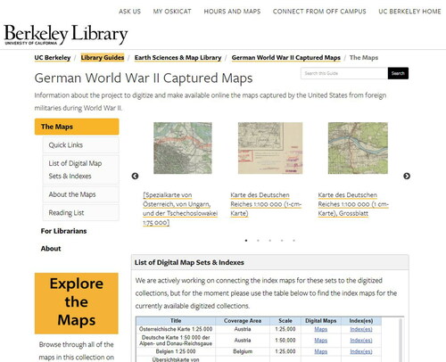
As UC Berkeley began receiving and processing the maps, the library staff were able to use the UC Riverside maps as one entry point to identifying captured map sets within the UC Berkeley Library collections. Library staff also used information such as corporate names and date ranges to search the library’s holdings for maps suspected to be captured German World War II maps. This list identified 273 bibliographic records held by UC Berkeley (of which 115 had only a single item), comprising 21,113 individual sheets. This information became the basis for a project to update catalog records (including the addition of provenance notes), digitize the sheets, and store the sets for preservation and protection from theft. Prior to the pandemic shutdown in March 2020, 40 map series had been cataloged and 10,208 sheets had been digitized. These were made available to the public in August 2020 through the soft launch on UC Berkeley Library’s digital collections site and the publication of an accompanying LibGuide ().
Figure 3. UC Berkeley Library’s LibGuide, created to accompany the soft launch of the German World War II Captured Maps digital collection, includes highlights from the collection, links to set indexes, and a reading list.
Importance of Provenance in Cataloging a Map Series
Cataloging cartographic resources is a data-driven exercise. Recording information such as relief, coverage area, scale information, and projection data necessitates unique data fields that are specific to cataloging cartographic resources. Map series can be large and complex, adding to the complications. For example, variation often plays a role as sheets are updated and reissued in new editions. Note fields have therefore become the friends of map catalogers by allowing for more descriptive catalog records that include details about the prime meridian, marginal data, sheet numbering, and more. Additionally, because map series catalog records provide access to and represent such large amounts of cartographic material, the authors argue that it is worth investing time in data-rich descriptions.
The authors encountered a variety of conundrums through the process of updating the map series catalog records in the course of UC Berkeley German captured maps project work. Some issues were revealed through looking at and attempting to understand the map series as whole entities, while other questions arose as the authors prepared map series for digitization and looked closely at individual sheets. Three areas the authors identified as particularly relevant and worth investment in for catalogers working with map series of this nature include local provenance tracings, authority control work, and documenting source data—all of which in a broader sense represent issues of provenance. These are explored briefly in turn below, followed by a few case studies that demonstrate different aspects of the complexity of delineating and cataloging these map series.
Local Approaches: Tracing Provenance, Managing Identities, and Tracking Source Map Data
An important aspect of UC Berkeley’s project has been to clearly identify maps that are part of the library’s German World War II Captured Maps collection through provenance and acquisitions tracings. Notes are used to record ownership and custodial history. Patrons are able to search on the collection name and find out which map series are part of this UC Berkeley collection. A standardized acquisitions note identifies these cartographic resources as “Maps distributed by United States Army Map Service following capture from foreign military during World War II.”
An important part of metadata creation is providing adequate authority control, recording all corporate bodies that are identified on these maps, such as cartographers, issuing bodies, or others that were involved in the production of the maps. In the decades after World War II, British and subsequently American map catalogers produced rudimentary record stubs for German military map sets. Instead of recording the full names of all corporate bodies which appear on the map sheets, some assigned responsibility by using a shorthand, employing ubiquitous phrases like “German General Staff.” As documented earlier, however, the German military mapping effort was organizationally much more complex. It relied on regionally operating Kriegskarten- und Vermessungsämter and military mapping units attached to armies and army corps as well as occupation governments to serve local needs. Therefore, many different corporate names therefore appear on the sheets. When cataloging UC Berkeley Library’s German captured maps, it was necessary to create authority records for local survey offices of the civilian Reichsamt für Landesaufnahme and small military mapping and surveying units assigned to work with particular German armies and occupation governments.
Another important task lies in tracing the origins of the source data used to create a map series. Which corporate bodies were involved in its creation? Were the data updated and through which methods? German World War II military map series usually reference the source data, sometimes extensively, with source map notes generally appearing in the lower-left corner of sheets. German war cartographers sometimes drew on a variety of source map sets to produce military map series. As discussed above, sets also at times were updated with aerial photography and fieldwork. The map series are not uniform. Although particular political and military challenges often defined production needs, production standards and capabilities generally improved during the war. Deutsche Heereskarte sheets which started to be published in 1942 generally provide more detailed information about data origins and updates than maps produced earlier.
Case Studies
The case studies from the Earth Sciences & Map Library of UC Berkeley presented below illustrate that the complicated histories of many map series are worth exploring and documenting. The description of source data and the tracing of contributing corporate bodies enrich our understanding of history and aid users in making better use of the collection.
Übersichtskarte von Mitteleuropa 1:300,000
A German map series with a long and fragmented history. It was issued by German military mapping agencies, as well as Civilian mapping agencies.The well-known Übersichtskarte von Mitteleuropa 1:300,000 was first issued from 1893 to 1918 by the Preußische Landesaufnahme, as discussed earlier, a military mapping agency of the State of Prussia, the largest and politically dominant German state. After the collapse of the German Empire (1871–1918), it was succeeded by the civilian Reichsamt für Landesaufnahme that issued new sheets of the Übersichtskarte von Mitteleuropa beginning in 1921. Reichsamt für Landesaufnahme cartographers made substantial changes. The new sheets emphasized roads and outdoor recreation features. Car owners and tourists emerged as an important map-buying audience. During World War II, sheets appeared which featured a new map series title “Übersichtskarte von Nord-, Mittel-, und Osteuropa 1:300,000.” Coverage was greatly expanded, particularly through sheets published between 1941 and 1943. After World War II, two German states emerged in 1949. In West Germany, state governments established mapping agencies, but very few Übersichtskarte sheets were issued in the decade after the war. In 1955, the West German government established the Institut für angewandte Geodäsie as the new national civilian mapping agency. It continued to issue Übersichtskarte sheets until about 1966.
The Übersichtskarte von Mitteleuropa changed substantially between 1893 and 1966. It was issued by three vastly different mapping agencies. The coverage area of this map series expanded during World War I and again dramatically during World War II, but in the 1950s and 1960s, it contracted to German territory. Key map features also changed. After some discussion, the authors decided those changes were significant enough to warrant dividing UC Berkeley’s set of Übersichtskarte von Mitteleuropa sheets into three sets. The reason for this decision was in part pragmatic. It conveniently allowed the library to separate the earlier sheets intended for digitization from those which the UC Berkeley Library bought in the 1950s and 1960s. But it also enabled within the bibliographic records a more detailed representation of the varied history and significant changes that took place during the more than 70 years of the Übersichtskarte von Mitteleuropa’s publishing history.
Austrian Spezialkarte 1:75,000
An Austrian military map series with a long history, published as a German military map series, its map data was repurposed for use in three other German map series.In March 1938, Nazi Germany annexed Austria. This was an important stepping stone in Adolf Hitler’s preparations for waging war. In Vienna, the Nazi regime gained access to important resources and capabilities: German civilian and military mapping agencies moved quickly to incorporate Austrian government institutions active in the fields of surveying and cartography. The new Vienna office of Germany’s civilian Reichsamt für Landesaufnahme absorbed Austria’s well-regarded Cartographic Institute, as well as the mapping and surveying staff of the Federal Office of Metrology and Surveying. The German military incorporated the Austrian Army’s survey office, which retained some of its distinct identity and operated under the name Heeresvermessungsstelle Wien.
Vienna played an important role within the German mapping operation during World War II because of unique local capabilities and cartographic staff expertise. Rather than reinvent the wheel, German military planners pragmatically worked within an established Austrian framework when they mapped parts of central and southeastern Europe. They continued to issue some Austrian map series with long traditions, among them the Spezialkarte der Österreichisch-Ungarischen Monarchie im Masse 1:75,000. Between 1873 and 1918, the Austro-Hungarian Empire’s Kaiserliches und Königliches Militärgeographisches Institut [= Imperial and Royal Military Geographic Institute] had published 752 sheets of this legendary map series. After the collapse of the Habsburg monarchy at the end of World War I, Austria’s Cartographic Institute and Hungarian, Czechoslovak, and German mapping agencies continued to issue updated sheets. The German military in turn used these as sources for the German military map series Spezialkarte von Österreich, von Ungarn, und der Tschechoslowakei 1:75,000, which was published between 1935 and 1944.Footnote4 The sheets of this series covered a large part of Central and Eastern Europe, the area where the Habsburg Empire had strategic interests. No wonder that German military planners took a special interest.
Austrian mapmakers working at the Cartographic Institute had also begun to repurpose Spezialkarte map data for a 1:50,000 topographic map series in the 1920s. This was another project German military planners found useful. They enlarged the scope of this effort, eventually publishing three 1:50,000 topographic map series covering Austria, Hungary, and much of the northern Balkans, respectively, using source map data from 1:75,000 Spezialkarte sheets and other sources (). All of these map series are well represented in UC Berkeley’s map collection which owns 420 sheets of the German military version of the Spezialkarte and also has strong holdings for the three 1:50,000 scale map series which repurposed its source map data.
Figure 4. Inset of the Zederhaus quadrangle (Deutsche Karte 1:50,000 der Alpen- und Donau-Reichsgaue sheet 5151 West) showing triangulation markings in red.
Norwegen/Finnland 1:50,000
A German military map series produced by a small motorized military mapping unit, Armee-Kartenstelle (mot.) 464. The unit served with the 20th German Mountain Army in Lapland during World War II.The regionally organized Kriegskarten- und Vermessungsämter, as well as local military mapping units attached to armies, army corps, and occupation authorities, played an important role in the German military mapping effort. The patchwork nature of the German military mapping organization, its need to improvise, its lack of standardization, its reliance on exploiting local resources—all these factors seem to indicate weakness. But there was also strength and flexibility in that patchwork quilt. Local bodies often responded more effectively to local needs, producing maps for use in both offensive and defensive actions.
Armee-Kartenstelle (mot.) 464 [= Army Map Post (motorized) 464]—a small military mapping unit—produced the German military map series Norwegen/Finnland 1:50,000 to support German mountain troops fighting on the Eastern Front against forces of the Soviet Red Army.Footnote5 This area of northernmost Norway and Finland and adjacent areas of the Soviet Union consists of forbidding terrain, largely permafrost tundra. One important challenge for the German military mapmakers was documenting Arctic tundra freeze-thaw cycles. Winters north of the Arctic Circle are long and summers are short. The active layer of permafrost, the topmost layer of soil, thaws in the summer and freezes in the winter. This, of course, greatly affects military operations.
In 1942, Armee-Kartenstelle (mot.) 464 had a staff of 53. The unit compiled maps utilizing Finnish, Norwegian, and Soviet source maps, Luftwaffe aerial photographs, and by performing field checks. It was motorized and equipped with trucks and half a trailer with the mapping and map printing equipment installed. Maps were chiefly printed in color. The unit established a base at Lager Neuer Kolonnenhof, a military camp of about 60–70 barracks, in Rovaniemi, Finland in January 1942, where it occupied a headquarters building, two garages for trucks, a workshop, a gas station, and other barracks. As the frontlines approached in October 1944 the German military mapping unit retreated to northernmost Norway (Mikkonen Citation2017).
Conclusion and Future Work
This article illustrates the complicated histories of many of the German captured map series. Variation within these rich cartographic resources makes it challenging to describe them. This is particularly true for the map series represented in UC Berkeley’s German World War II Captured Maps collection, which might best be described as a moving target. Cartographic resources produced before the war reflected many of the weaknesses of the German military mapping operation, particularly the lack of standardization and integration. But during the war years, that picture gradually started to change and real innovation happened.
With care, bibliographic catalog records can reflect some of the complexity that underlies so many of the German captured map series, thereby providing the library community and users of the maps with additional useful contextual information. An important goal of map metadata creation is providing provenance information to patrons and the library community. Traditionally, this has meant a focus on local data fields which provide information about special collections, previous owners, and gifts. Historical map series provide a special challenge, because of their sheer size and the complexity of the data sets.
Enlarging upon an overly narrow definition of provenance offers opportunities. The German captured maps deserve that treatment. After all, this is not merely an empty exercise or mental puzzle. These maps were the tools of a regime that murdered millions of people. By carefully re-assembling the German maps collection and describing the map series, we as a map library community can help scholars use these former tools of aggression to shine a light on the regime’s oppression and the atrocities that it perpetrated.
Scholars have researched the German captured maps, but there is still much to understand. Although this paper has featured examples of topographic map series—by far the most common type of map series represented in the German captured maps collection—the Nazi military also made use of many other types of maps. Non-topographic map series produced by the German military include such diverse types as road maps, city plans, nautical charts, thematic maps such as census maps, geological maps, terrain-study maps, and resource inventories used by the Nazi administration to administer and exploit occupied territories. Produced in smaller print runs these are not as widely held in U.S. research libraries, but contain rich additional information and would be worth additional study.
Encouraging more scholarship about local U.S. holdings of German World War II captured maps remains an important goal for learning more about the variety of experiences and collections. The authors look forward to increased collaboration amongst map libraries in documenting and making available these hidden collections. By sharing documentation, catalog records, and inventories we as a community can work together to create a whole greater than the sum of its parts. The authors also propose a close-up look at the other side of the Atlantic and collaborations with cultural institutions in Europe. Maps produced by German military and civilian bodies during the Nazi regime were scattered in the final phase of World War II and in the war’s aftermath. Collections in many places hold keys to some of the puzzles discussed in this paper. The collective knowledge we build about these maps will be a service to future scholars.
Acknowledgments
This article and the UC Berkeley Library’s World War II Captured Maps project would not have been possible without the work of many others. We would be remiss if we did not acknowledge the efforts of Library IT for their work managing and digitizing the maps, adding them to the digital collections site, and more; Northern Regional Library Facility (NRLF) staff for their work managing the retrieval and storage of the maps; Earth Sciences & Map Library staff for their logistical support; Interlibrary Services and Mail & Transportation Services; Library Administration for their support of the project; and Janet Reyes of the UC Riverside Library for project inspiration and map shipping/organization.
The authors would like to thank Randy Brandt and Philip Hoehn for sharing their institutional knowledge and contributing to the research on the history of UC Berkeley Library’s World War II captured maps collection. Due to the pandemic, we would not have had access to the library’s archives without Randy’s assistance. We would also like to extend our thanks to John Anderson, Greg March, Julie Sweetkind-Singer, Dierk Willig, and Marek Zielinski for sharing documents and ideas related to the history of the AMS World War II captured maps program. We are grateful to the editors and reviewers of this journal for their thoughtful comments which have strengthened our article.
Notes
1 In 1998 the Research Collections Committee of the Association of Research Libraries (ARL) found that no systematic data had been collected on special collections in ARL libraries for nearly 20 years. “Special collections in ARL libraries” proved to be a milestone. The ARL survey found that a “significant portion” of special collections materials had not been processed and cataloged. Therefore those collections could not be discovered, were not known to researchers, and could not be used (Panitch Citation2001). A subsequently issued ARL white paper "Hidden collections, scholarly barriers: Creating access to unprocessed special collections materials in North America’s research libraries" prominently featured the term "hidden collections" (Jones Citation2003). Since 2008, grants provided by the Council on Library and Information Resources (with funding from the Andrew W. Mellon Foundation) have helped rectify these deficiencies and spotlight the importance of historic collections (Banks Citation2019).
2 The chart “Geographic and Mapping Units of the German Armed Forces” in the CIA report “MIL-GEO: The Geographic Service of the German Army” identifies these bodies within the Nazi regime’s military organizational structure (CIA 1951, Chart 3084).
3 Building on Karl Dietrich Bracher’s influential analysis of the breakdown of the Weimar Republic’s political system and Adolf Hitler’s path to power, English-speaking historians have adopted the shorthand “Nazi seizure of power” to describe the events of the years 1930–1934 (Bracher Citation1970). The Nazis themselves coined the German word Machtergreifung [= seizure of power] to emphasize the revolutionary character of their efforts to destroy the Weimar Republic. Bracher utilized this term in his writings in the 1950s and 1960s to emphasize the extra-legal means the Nazis used to gain control of the government, construct an autocratic regime, and pursue a systematic program of Nazification. Hermann Beck, in a notable recent addition to the literature, used Machtergreifung in an English-language book title (Beck Citation2008). For an up-to-date discussion of the historiographical debates see the introductory chapter of From Weimar to Hitler (Beck & Jones Citation2019).
4 The source maps were issued by a range of state bodies including the Kartographisches Institut, Vojenský zeměpisný ústav, Magyar Királyi Állami Térképészet, Topographische Zweigstelle des Bayerischen Landesvermessungsamts, and the Reichsamt für Landesaufnahme’s Hauptvermessungsabteilung XIV in Wien.
5 Armee-Kartenstelle 464, an army formation, administratively subordinated to Armeeoberkommando Lappland, which was subsequently renamed Armeeoberkommando 20. Gebirgsarmee. The formation appears on rosters of subordinated units dated 25 June 1942, 1 August 1944, 21 October 1944 and 1 January 1945 (Lexikon Citation2021).
References
- Albrecht, O. 1969. Das Kriegsvermessungswesen während des Weltkrieges 1914–1918. München: Bayerische Akademie d. Wissenschaften; Beck in Komm.
- Albrecht, O. 2004. Beiträge zum militärischen Vermessungs- und Kartenwesen und zur Militärgeographie in Preußen (1803–1921). Euskirchen: Amt für Geoinformationswesen der Bundeswehr.
- Anderson, J. M. 2001. Forgotten battles, forgotten maps: Resources for reconstructing historical topographical intelligence using Army Map Service materials. Historical Geography 29:79–91. https://ejournals.unm.edu/index.php/historicalgeography/article/view/2999.
- Banks, J. M. 2019. The foundations of discovery: A report on the assessment of the impacts of the Cataloging Hidden Collections Program, 2008–2019. Arlington, VA: Council on Library and Information Resources. Accessed February 3, 2021. https://www.clir.org/wp-content/uploads/sites/6/2016/09/pub177.pdf.
- Beck, H. 2008. The fateful alliance: German Conservatives and Nazis in 1933: The Machtergreifung in a new light. New York: Berghahn Books.
- Beck, H., and L. E. Jones. 2019. Introduction: The Nazi seizure of power in historical and historiographical perspective. In From Weimar to Hitler: Studies in the dissolution of the Weimar Republic and the establishment of the Third Reich, 1932–1934, ed. Hermann Beck and Larry Eugen Jones, 1–22. New York: Berghahn Books.
- Böhme, R. 1978. Der Verbleib der Originale der amtlichen Kartenwerke des Deutschen Reiches. Frankfurt am Main: Verlag des Instituts für angewandte Geodäsie.
- Bracher, K. D. 1970. The German dictatorship: the origins, structure, and effects of National Socialism. New York: Holt, Rinehart and Winston.
- CIA (Central Intelligence Agency). 1951. Mil-Geo: The Geographic Service of the German army. M-12. Washington, DC: Central Intelligence Agency. Accessed March 29, 2021. http://maps.mapywig.org/m/m_documents/EN/MIL-GEO_THE_GEOGRAPHIC_SERVICE_OF_THE_GERMAN_ARMY_1951.pdf. [Note: Report originally classified. Includes overprint stating: “Declassified in Part - Sanitized Copy Approved for Release 2013/02/20”]
- Coney, D. 1945. Letter to W. D. Milne, 26 December. University of California, Berkeley Library records, 1902–2014, box 100, folder 6. Bancroft Library, University of California, Berkeley.
- Crampton, J. 2011. Arthur Robinson and the creation of America’s first spy agency. In Proceedings of the 25th International Cartographic Conference, Paris, France, 3–8 July 2011, ed. Anne Ruas [CO-174]. https://icaci.org/files/documents/ICC_proceedings/ICC2011/Oral%20Presentations%20PDF/B4-Maps,%20GIS,%20security%20and%20planning/CO-174.pdf.
- Cruickshank, J. L. 2005. The Reichsamt für Landesaufnahme and the Ordnance Survey (Part 1). Sheetlines 72 (April 2005):9–22. https://www.charlesclosesociety.org/files/Issue72page9.pdf.
- Dowd, S. 1961. Map collection of the University of California at Berkeley. Special Libraries Association Geography and Map Division Bulletin 43:13–4.
- Eggers, W. 1974. Kriegskarten im Zweiten Weltkrieg: Planung und Herstellung. Fachdienstliche Mitteilungen Des Obersten Fachvorgesetzten Des Militärgeographischen Dienstes 10:19–34.
- Gimbel, J. 1990. Science, technology, and reparations: Exploitation and plunder in postwar Germany. Stanford, CA: Stanford University Press.
- Hadden, R. 2008. The Heringen collection of the US Geological Survey Library, Reston, Virginia. Earth Sciences History 27 (2):242–65. doi: https://doi.org/10.17704/eshi.27.2.y1vq1168q51g1542.
- Hagen, C. 1979. Map libraries and the Armed Services—a story of uneven relationships. Western Association of Map Libraries Information Bulletin 11:3–22.
- Jones, B. M. (compiler). 2003. Hidden collections, scholarly barriers: Creating access to unprocessed special collections materials in North America’s research libraries [white paper]. Association of Research Libraries Task Force on Special Collections. Accessed February 3, 2021. https://www.arl.org/wp-content/uploads/2003/06/hidden-colls-white-paper-jun03.pdf.
- Klinkenberg, Hans Martin, ed. 1970. Rheinisch-Westfälische Technische Hochschule Aachen 1870–1970. Stuttgart: Oscar Bek Verlag.
- Kneissl, M. 1969. Generalleutnant Gerlach Hemmerich, sein Werk und Wirken: Eine Studie zu seinem 90. Geburtstag am 4. Februar 1969. München: Verlag der Bayerischen Akademie der Wissenschaften (in Kommission Verlag C.H. Beck).
- Lang, H. 2008. Deutschlands Vermessungs- und Kartenwesen: Aspekte seiner Entwicklung seit der Reichsgründung 1871. Dresden: Schütze, Engler, Weber Verlags GbR.
- Lexikon Der Wehrmacht - 20. Gebirgs-Armee. 2021. Accessed February 5, 2021. http://www.lexikon-der-wehrmacht.de/Gliederungen/ArmeenGeb/20GebArmee.htm.
- Merriam-Webster. 2021. Definition of provenance. Dictionary. https://www.merriam-webster.com/dictionary/provenance.
- Mikkonen, K. 2017. Parakkeja ja piikkilankaa: Saksan armeijan rakentamiseen liittyvä toiminta Rovaniemen seudulla, 1940–1944 [Barracks and barbed wire: Activities related to the construction of the German army in the Rovaniemi region 1940–1944]. Lapin maakuntamuseon julkaisuja 18. Rovaniemi, Finland: Lapin maakuntamuseo. https://www.rovaniemi.fi/loader.aspx?id=8100cbe5-70b3-40a6-b94e-69432a98b777.
- Miller, G. 2019. The untold story of the secret mission to seize Nazi map data. Smithsonian Magazine. https://www.smithsonianmag.com/history/untold-story-secret-mission-seize-nazi-map-data-180973317/.
- Monmonier, M. 2005. Mapping under the Third Reich: Nazi restrictions on map content and distribution. ALA Map and Geography Round Table Coordinates Series B, No. 2. http://hdl.handle.net/1969.1/129192.
- Müller, T., and D. Hubrich. 2009. Überblick über das Karten-und Vermessungswesen des deutschen Heeres von 1919 bis 1945. Euskirchen: Amt für Geoinformationswesen der Bundeswehr.
- Neumann, J. 2015. Military mapping by Germany. In History of cartography, ed. M. Monmonier, vol. 6, 909–21. Chicago: University of Chicago Press.
- Oehrli, M., and M. Rickenbacher. 2014. Deutsche Kriegskarten der Schweiz, 1939–1945: Ein Vademecum. Murten: Cartographica Helvetica.
- OSU/AMS Correspondence, 1944–1947. University of Washington Libraries web guide “Gaihozu: Why are the Gaihozu at UW?” Accessed January 15, 2021. https://guides.lib.uw.edu/research/gaihozu/why. https://guides.lib.uw.edu/ld.php?content_id=42914863.
- Paige, A, et al. Forthcoming. ‘Will work for maps’: A history of the library of congress geography and map division special map processing project. Journal of Map & Geography Libraries 16 (2).
- Panitch, J. M. 2001. Special collections in ARL libraries: Results of the 1998 survey: sponsored by the ARL Research Collections Committee. Washington, DC: Association of Research Libraries. Accessed February 3, 2021. https://www.arl.org/wp-content/uploads/2007/06/special-collections-arl-libraries.pdf.
- Peiss, K., 2020. Information hunters: When librarians, soldiers, and spies banded together in World War II Europe. New York, NY: Oxford University Press. doi: https://doi.org/10.1093/oso/9780190944612.001.0001.
- Quill, T., and M. Dalmau. 2019. Capture and release: The story of the Russian military topographic map collection. Cartographic Perspectives, (93):65–67. doi: https://doi.org/10.14714/CP93.1567.
- Reyes, J. 2020. A workbook for conducting a map collection review. Lightning talk presented at the Western Association of Map Libraries virtual conference, October 16.
- Ruzek, C. V. 1950. Memo to ‘all AMS depositories’ with subject: ‘Foreign maps’.
- Scharfe, W. 2003. German army map of Spain 1:50.000: 1940–1944. In Proceedings of the 21st International Cartographic Conference, Durban, South Africa,10–16 August, 2003, 2475–95. Durban: International Cartographic Association. https://www.icaci.org/files/documents/ICC_proceedings/ICC2003/Papers/323.pdf.
- Sweetkind-Singer, J., and G. March. Forthcoming. Acquisition of World War II captured maps: A case study. Journal of Map & Geography Libraries 16 (2).
- Tatham, A. F. 1978. German military mapping—an exploratory survey. The Cartographic Journal 15 (1):20–7. doi: https://doi.org/10.1179/caj.1978.15.1.20.
- Torge, W. 2007. Geschichte der Geodäsie in Deutschland. Berlin: Walter de Gruyter.
- U.S. Army. 1968. Corps of Engineers, Army Map Service. Washington: Army Map Service.
- Willig, D. 2009. Die Odyssee des Wehrgeologenarchivs als Teil der Heringen Collection: Versuch einer Rekonstruktion der Vorgänger von März 1945 bis heute. Euskirchen: Amt für Geoinformationswesen der Bundeswehr.
- Wilson, L. S. 1949. Lessons from the experience of the Map Information Section, OSS. Geographical Review 39 (2):298–310. doi: https://doi.org/10.2307/211051.
Appendix A:
Timeline of major events in the history of German mapping agencies (1921–1945)
Created using the “Vertical Timeline Using Shapes” template from Vertex42.com.