
ABSTRACT
GIS Day is an annual, international celebration of geographic information systems (GIS) and geospatial technologies that provides organizations with an opportunity to help others learn about the real-world applications and positive societal impacts of geography and GIS, highlight services, and celebrate accomplishments. Many academic libraries participate in GIS Day programs, using this well-known event to engage with their campus and local communities. In this article, we build on earlier research conducted by Weimer, Olivares, and Bedenbaugh to reassess the landscape of Association of Research Libraries (ARL) member involvement in GIS Day programs and, in particular, how these events demonstrate the educational and collaborative aspects of geospatial information services in libraries. For our web content analysis, we specifically focus on gathering information about GIS Day programs in 2019 and 2020, allowing for an examination of how libraries participating in GIS Day responded to the operational challenges posed by the COVID-19 pandemic, as well as new opportunities that may have emerged during this period. Finally, we offer our own 2020 GIS Day program as a brief example highlighting how it led to our first cross-institutional collaboration and fostered new opportunities for promoting and partnering on digital scholarship projects at our institutions.
Introduction
GIS Day is an international celebration of geographic information systems (GIS) and geospatial technologies. With Esri as one of its primary sponsors, GIS Day began in 1999 and has since been held annually on the Wednesday of Geography Awareness Week, which occurs during the third week of November (Esri Citation2000; Sinton Citation2017). While the number of GIS Day programs has grown over the years and the types of activities included have evolved, the main goals of GIS Day have largely remained consistent: to help others learn about the real-world applications and positive societal impacts of geography and GIS, to empower organizations to highlight services and celebrate accomplishments, and to inspire others to discover and use GIS (Esri Citationn.d.).
Academic libraries engaging in GIS and geospatial information services will likely recognize considerable alignment between the goals of GIS Day and the broad outreach, education, and service missions associated with their geospatial programs. As others have stated, for libraries in particular and outreach organizations generally, GIS Day provides an excellent opportunity for raising awareness, promoting services, and engaging with communities around GIS (Houser Citation2006; Weimer, Olivares, and Bedenbaugh Citation2012; Sinton Citation2017). Indeed, as Sinton (Citation2019) notes in discussing trends emerging over 20 years of GIS Day observance, the involvement of libraries in planning and hosting such events has increased notably over the decades.
Despite recognition of the outreach opportunities afforded by an established event like GIS Day and a trend of increasing library involvement, such programs have been treated sparingly in the library and information science literature. In offering helpful recommendations to early-career GIS librarians, Martindale (Citation2004, 71) highlights GIS Day as an opportunity to “invite the general public as well as the university community to come into the library to learn about GIS and how it affects everyday life.” Dixon (Citation2006) notes the libraries’ role at the University of Arkansas in hosting a GIS Day program with the mutual benefit of promoting GIS and bringing GIS researchers and students from various disciplines together in a library space for networking and discussing potential GIS collaborations. Likewise, Houser (Citation2006, 323) highlights the libraries’ participation in the GIS Day program at the University of Kansas, describing such events as “excellent opportunities to make and maintain contacts and raise awareness of library GIS services.”
In their discussion of data and GIS service models, Scaramozzino et al. (Citation2014) specifically mention hosting or co-hosting GIS Day events as an outreach strategy for four of the five university libraries profiled in the article. Sare, Olivares, and Weimer (Citation2013) discuss several lessons learned from hosting GIS Day programs at Texas A&M University, with one important benefit being increased opportunities to network with local government agencies, which strengthened the libraries’ relationships with those groups in ways that supported the university’s research agenda. Again focusing on Texas A&M University, Laddusaw et al. (Citation2017) note the evolution of their GIS Day program from a three-hour booth into a three-day event. They provide a timeline showing how the University Libraries event developed into a collaboration with the Department of Geography and then into a larger collaboration with representatives from five colleges and two support units across the university. This same idea of interdisciplinary collaboration and interest in GIS Day programs is also reflected in the work of Kong, Fosmire, and Branch (Citation2017), who highlight GIS Day as one outreach strategy for engaging with humanities and social science researchers. The authors discuss how their interactions with researchers in these areas led them to modify their practices around organizing GIS Day programs at Purdue University, including inviting faculty and graduate students in these disciplines to serve as members of the GIS Day planning committee and inviting keynote speakers to present on emerging GIS applications based on humanities and social science researchers’ requests.
The publications discussed above offer valuable perspectives on GIS Day activities in academic libraries, though most only briefly mention GIS Day in the context of broader studies. The two most substantial discussions of GIS Day in the library and information science literature include contributions by McAuliffe (Citation2014) and Weimer, Olivares, and Bedenbaugh (Citation2012). McAuliffe (Citation2014) discusses GIS Day as an opportunity for libraries to highlight GIS resources for STEM students and professionals before offering practical tips to aid individuals in organizing their own library-based GIS Day programs. Topics covered include defining the event scope and goals, planning the program (including potential partners, activities, and other logistical details), marketing and hosting the program, and post-event tasks.
Weimer, Olivares, and Bedenbaugh (Citation2012) perform a web content analysis for every academic-based U.S. member library of the Association of Research Libraries (ARL) in an attempt to characterize academic libraries’ participation in GIS Day events at their institution between 1999-2010. From this analysis, the authors indicate that 26% of the 99 institutions included in the study showed web evidence of library participation in a GIS Day program at least once between 1999-2010. The authors focus much of their attention on the role of outreach in academic libraries and the opportunities afforded by events like GIS Day “to both introduce users to GIS services and to surprise them with the notion that you can get these services at the library, thus enhancing and expanding the library image” (Weimer, Olivares, and Bedenbaugh Citation2012, 43). Through this work, the authors provide a detailed perspective on academic library participation in GIS Day programs, offer valuable recommendations related to web promotion for such activities, and put forward a call to action for libraries, especially those with GIS services, to participate in GIS Day events at their universities.
The purpose of the present study, in part, is to revisit the earlier work of Weimer, Olivares, and Bedenbaugh (Citation2012) and to reassess the landscape of ARL library involvement in GIS Day programs roughly a decade later. We also build on this earlier study, which focused on evidence of library participation in GIS Day, by characterizing the logistical features and types of activities associated with these events. We specifically focus on gathering information about GIS Day programs at ARL libraries in 2019 and 2020. In doing so, we are also able to examine how libraries participating in GIS Day responded to the operational challenges posed by the COVID-19 pandemic, as well as new opportunities that may have emerged during this period. Finally, we offer our own 2020 GIS Day program as a brief example highlighting how it led to our first cross-institutional collaboration and fostered new opportunities for promoting and partnering on digital scholarship projects at our institutions. This research will support a growing community of practice among map, geospatial, data, and subject librarians by describing the logistical features and types of activities associated with library-based GIS Day programs and by advancing ideas around how we can meaningfully engage with our communities on GIS Day and beyond.
Methodology
We used a comparable study sample and methodology to that described by Weimer, Olivares, and Bedenbaugh (Citation2012). We similarly focused on ARL libraries that are affiliated with a university, but unlike this earlier work, we also included Canadian ARL member libraries in our analysis. At the time our project was conducted, there were 124 ARL member libraries, 116 of which were academic libraries included in our analysis.Footnote1 We performed a web content analysis as an unobtrusive mechanism of identifying GIS Day programs associated with ARL member library/university pairs based on information collected from public-facing event web pages.
We used the following web search strategies to locate GIS Day event web pages associated with ARL members for 2019 and 2020: 1) keyword searching for GIS and GIS Day on ARL library websites, 2) keyword searching for GIS and GIS Day on ARL university websites, 3) browsing ARL libraries’ current and past event calendars when available, 4) browsing ARL libraries’ GIS services web pages when available, and 5) conventional web searching for GIS Day in combination with institution name and year if relevant GIS Day event pages were not discovered via other strategies. We conducted a first round of searching between October 28-November 17, 2020 to identify event pages posted prior to GIS Day 2020 (November 18) and a second round between November 19-25, 2020 to identify events that may not yet have been posted or were not otherwise identified during the first round of searching. We acknowledge a similar limitation in this methodology to one noted by Weimer, Olivares, and Bedenbaugh (Citation2012), namely that web page stability may have affected our ability to discover all GIS Day programs occurring at these institutions, particularly when retrospectively searching for 2019 events.
We examined the GIS Day event pages in detail to code a series of fields separated into the categories of logistics and activities. When links to external resources associated with the GIS Day program were included on the library or university event web page, such as promotional flyers, registration forms, or social media event listings, we examined that content as well. provides information about the fields we coded in the logistics category, including subcategories, field names, and descriptions. It is important to note that aside from those in the duration subcategory, the coded fields are not mutually exclusive. For example, a program could be coordinated with partners in multiple groups (cross-departmental, cross-institutional, etc.); a program might have components with different modes of delivery; and a program might have components with different intended audiences.
Table 1. Logistical features considered for GIS Day programs across ARL member institutions in 2019 and 2020.
provides information about the fields we coded in the activities category, which we divided into subcategories for active learning, presentations, showcasing, and networking. We coded all fields across the logistics and activities categories as either ‘not evident’ (0) or ‘evident’ (1). As our study relied on information from public-facing event web pages, which contained varying levels of detail, we could not be more definitive in our coding. For example, some event pages provided a detailed list of coordinators or sponsors, which served as evidence of library participation and independent or joint coordination of the program, while other event pages did not include these details. Some event pages provided a detailed program schedule with descriptive information, which served as evidence that certain types of activities took place, while other event pages did not provide a detailed agenda. In cases where these details were lacking, certain logistical features or activities may have occurred, but we were not able to identify evidence of that on the event web pages.
Table 2. Types of activities considered for GIS Day programs across ARL member institutions in 2019 and 2020.
Finally, like Weimer, Olivares, and Bedenbaugh (Citation2012), we focused our search on dedicated GIS Day events. However, if a GIS Day event was described as one component of a larger, integrated program, such as a series of events for Geography Awareness Week, we based our coding of logistics and activities on all of the information provided for that integrated program. This allowed us to capture more complete information about the ways that GIS Day events are organized across ARL member institutions, whether as a discrete event or as one part of a larger program.
Results
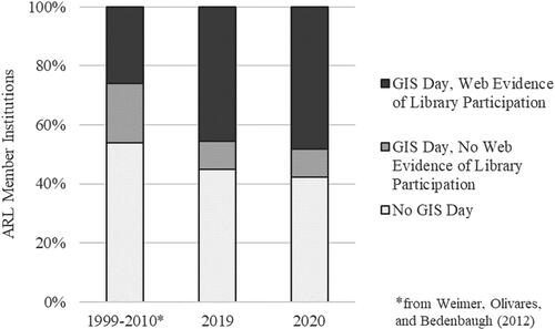
Information about GIS Day programs was located on the web pages of 64 (55.2%) ARL library/university pairs in 2019 and 67 (57.8%) in 2020. Web evidence of library participation in GIS Day was present for 53 (45.7%) ARL member institutions in 2019 and 56 (48.3%) in 2020. shows the percentage of institutions included in this study with no web evidence of GIS Day, evidence of GIS Day but not library participation, and evidence of GIS Day with library participation, as well as these same measures reported by Weimer, Olivares, and Bedenbaugh (Citation2012, 46) for their study spanning 1999-2010. A notable increase can be seen in the percentage of ARL libraries participating in GIS Day programs in 2019 and 2020 compared to 1999-2010. This increase may be partially, but not completely, explained by the inclusion of the 16 Canadian ARL member institutions in our study, whereas they had previously been excluded. Instead, this increase is likely due to a combination of more ARL libraries participating in GIS Day and greater use of library websites to communicate information about these events (including past events), both of which were recommendations made by Weimer, Olivares, and Bedenbaugh (Citation2012). This increase is even more pronounced if we consider the number of unique ARL libraries that participated in GIS Day programs in either 2019 or 2020. Web evidence of GIS Day participation was found for 38 libraries for both 2019 and 2020, 15 libraries for 2019 only, and 18 libraries for 2020 only, for a total of 71 (61.2%) participating libraries over this two-year span.
Figure 1. ARL member institution participation in GIS Day programs for 1999-2010, 2019, and 2020 based on web content analysis.
For the purposes of examining logistical features and types of activities in more detail, we will only consider those GIS Day programs with evidence of library participation. provides summary data for logistical features, with counts representing the number of ARL libraries participating in GIS Day programs with these characteristics (and not the number of unique GIS Day programs). allows for a visual comparison of GIS Day logistics in 2019 and 2020, with some interesting patterns emerging. While there is an expected shift from predominantly in-person events in 2019 (LM1) to virtual eventsFootnote2 in 2020 (LM2) due to the operational challenges posed by the COVID-19 pandemic, it is also interesting to note the apparent shift toward greater participation in multi-day programs in 2020 (LD1/LD2). Another striking result in terms of GIS Day logistics relates to the types of collaborations represented. While most of the fields in the coordination subcategory remain relatively consistent, there is a dramatic increase in the number of ARL libraries participating in cross-institutional GIS Day programs in 2020 (LC3; 53.6%) compared to 2019 (3.8%).
Figure 2. Logistical features associated with ARL library participation in GIS Day programs in 2019 and 2020.
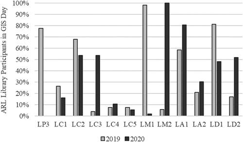
Table 3. Summary data for the logistical features of ARL library participation in GIS Day programs in 2019 and 2020. Counts represent the number of libraries participating in GIS Day programs with these features.
provides summary data for the types of activities associated with ARL library participation in GIS Day programs in 2019 and 2020. allows for a visual exploration of the activities included in GIS Day programs within and across the two years we analyzed for this study. The rank order of the four most frequent activities associated with ARL library GIS Day programs remained consistent across 2019 and 2020, including paper presentations/lightning talks (AP2), featured speakers/panel discussions (AP1), networking sessions — including professional development topics (AN2), and workshops (AL1). However, other predominant activities differed across the years. In 2019, more ARL libraries participated in GIS Day programs that included space/technology showcases - including technology vendor sessions (AS1; 39.6%), poster presentations (AP3; 35.8%), and resource/career fairs (AN1; 22.6%). In 2020, more ARL libraries participated in GIS Day programs that included map galleries - with contributions created by event attendees (AS3; 37.5%), games/trivia (AN3; 32.1%), and mapathons (AL2; 30.4%). These differences highlight ways that GIS Day coordinators adapted their programs in 2020, ostensibly shifting away from some activities better-suited for in-person events to others more conducive to virtual participation.
Figure 3 Types of activities associated with ARL library participation in GIS Day programs in 2019 and 2020.
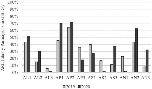
Table 4. Summary data for activities associated with ARL library participation in GIS Day programs in 2019 and 2020. Counts represent the number of libraries participating in GIS Day programs including these types of activities.
Discussion
Our web content analysis of ARL member institutions in 2019 and 2020 indicates that the number of libraries participating in GIS Day programs has increased substantially since Weimer, Olivares, and Bedenbaugh (Citation2012) found web evidence of GIS Day participation for only 26% of ARL libraries between 1999-2010. In addition, we found web evidence that 38 of the 53 libraries (71.7%) that participated in GIS Day in 2019 also participated in 2020. Depending on the size and scope of the program, planning for GIS Day can be one of the more significant outreach tasks undertaken by map and geospatial librarians and staff, even under the best of circumstances. The fact that so many libraries prioritized coordinating and participating in GIS Day programs that needed to be adapted for virtual environments in 2020 speaks to the perceived value these programs have as part of academic libraries’ outreach strategies.
We also found considerable variation in the size and scope of these programs. Some were relatively small and focused, consisting of only one or two activities, such as a workshop, featured speaker, or map gallery. Others were large and wide-ranging, consisting of many different types of activities and stretching over multiple days. We trust that GIS Day program organizers are working to design what they expect will be the most effective events for their institutional contexts and outreach goals, including perhaps choosing not to participate in GIS Day in favor of other types of activities that we will not have captured as part of this analysis, given our focus on dedicated GIS Day events. At the same time, we echo the sentiments of Weimer, Olivares, and Bedenbaugh (Citation2012) that well-known events like GIS Day provide libraries with a significant opportunity to promote geospatial resources and services in context and to broad audiences.
One useful way of thinking about GIS Day programs in academic libraries can be to draw on the tiered approach to GIS outreach described by Dodsworth (Citation2010). Under this approach, tier one activities are designed so that participants “will take away with them a general knowledge of what GIS technology can do,” while tier two activities demonstrate the uses of GIS in specific fields so that participants “will have enough of an introduction to warrant the technology as an option for research, analysis or as a map-making tool” (Dodsworth Citation2010, 27). Depending on their organizers’ goals, individual GIS Day programs can be designed as a blend of tier one (e.g., introductory workshops, mapathons, exhibits) and tier two activities (e.g., disciplinary presentation tracks, specialized workshops), as well as an additional tier aimed at engaging with more advanced users of GIS and geospatial technologies. Alternatively, libraries can design GIS Day programs with one tier in mind to complement other outreach activities they may already be engaging in at other tiers.
We also suggest a reframing of GIS Day programs in academic libraries to move the conversation beyond outreach and toward education. With this, we do not seek to diminish the role GIS Day programs can play in interdisciplinary library outreach, including demonstrating expertise, promoting geospatial services and resources, and engaging with various user communities. Rather, we wish to emphasize the role that libraries play in geography and GIS education at their institutions and how these same three goals (and more) are equally applicable when viewed through an educational lens.
Our web content analysis indicates that many participating libraries are including hands-on educational activities, which we have coded in the active learning subcategory, as part of their GIS Day programs. In both 2019 (43.4%) and 2020 (51.8%), workshops ranked as the fourth most predominant activity among ARL libraries participating in GIS Day programs. In contrast, workshops were not mentioned in the long list of activities Weimer, Olivares, and Bedenbaugh (Citation2012) discovered for ARL institutions participating in GIS Day programs between 1999-2010. The fact that a majority of participating libraries included workshops in their GIS Day programs in 2020, presumably developing new workshops or redesigning existing in-person activities for virtual delivery, is indicative of the perceived value of GIS Day as an informal or cocurricular educational opportunity. Though less frequent than workshops, mapathons are another active learning activity included as part of libraries’ GIS Day programs. Recent discussions of humanitarian mapathons in the library and information science literature emphasize the role these types of activities can play in teaching spatial and data literacy concepts, as participants both use and create geospatial data, often interpreting remotely-sensed imagery to digitize vector features such as buildings and roads (Quill Citation2018; McGowan Citation2020). In their discussion of humanitarian mapathons at Indiana University, Quill (Citation2018, 167) also indicates that mapathon participation has been more academically diverse than for other geospatial workshops, in that they “attracted participants from a wide variety of disciplines, as well as university staff, faculty, and community members.”
This educational reframing of GIS Day programs in academic libraries extends beyond hands-on experiences to presentations as well, with a focus on research, teaching, or professional applications of GIS. In their valuable discussion of library programming as pedagogy, Kasten-Mutkus (Citation2020, 425–426) states,
“Research-centric programming, in which scholarship is presented and discussed, is also an opportunity to define the library, to engage with the academic community, and to promote interdisciplinarity. Students are encouraged to view their learning as continuous with the research process and to regard the library as a nexus for scholarship and the exchange of knowledge.”
These kinds of scholarly programs, such as faculty speakers, panel discussions, and paper/poster presentations, also provide “an opportunity to extend concepts taught in an information literacy context and to allow students to see them in action” (Kasten-Mutkus Citation2020, 428). One need only add data and spatial literacy to that statement to recognize how activities that are already common in GIS Day programs across academic libraries (see ) can be appreciated as important cocurricular educational opportunities.
A final aspect of GIS Day programs in academic libraries that we would like to emphasize is their role in facilitating connections and collaborations, among both event participants and event coordinators. As Dixon (Citation2006) notes, events like GIS Day that bring together researchers and students from across a variety of disciplines provide a venue for networking and sharing ideas that could potentially lead to future collaborations. In addition to presentation sessions, which provide one setting for exchanging ideas and connecting with possible collaborators, many library-based GIS Day programs include networking sessions as another means of facilitating connections among event participants (see ).
GIS Day programs are also often jointly coordinated, with potential partners from other university departments, other institutions, the local community, and the geospatial industry (see ). Even when a program is not collaboratively organized, it still might involve inviting faculty speakers from across campus or including local GIS professionals in presentation or networking activities, helping to build or strengthen relationships that could prove beneficial in contexts outside of GIS Day (Kasten-Mutkus Citation2020; Sare, Olivares, and Weimer Citation2013). One striking result uncovered through our web content analysis was the increase in cross-institutional collaborations among ARL libraries participating in GIS Day, from two institutions (3.8%) in 2019 to 30 institutions (53.6%) in 2020. It seems that one way academic libraries adapted their GIS Day programs when facing the operational challenges posed by the COVID-19 pandemic was simply to work together. Additionally, for the 18 ARL libraries with web evidence of GIS Day participation in 2020 but not 2019, all but three involved some type of joint coordination, and 12 (66.7%) participated in cross-institutional collaborations. For libraries that may not yet regularly participate in GIS Day programs or that chose not to organize a virtual event in 2020, one option might be to draw on a network of map and geospatial librarians and staff from other institutions as possible collaborators.
To build on this idea, we will close our discussion by offering our own GIS Day program in 2020 as a brief example. Our experiences as we planned our first cross-institutional and virtual GIS Day program led us to wonder what other academic libraries were planning for GIS Day in 2020 and how these programs might differ from what had been done before. We undertook the present study with these questions in mind, and we see some of our own experiences and lessons learned reflected in the findings described above.
3C GIS Day
3C GIS Day (for Cleveland-Columbus-Cincinnati) was a cross-departmental and cross-institutional GIS Day collaboration, with coordinators from Case Western Reserve University, The Ohio State University, and the University of Cincinnati. The main goals of this collaboration were to highlight geospatial applications across a variety of disciplines and facilitate connections between researchers, students, and professionals across our respective institutions and regions. These shared goals directly influenced our choice of activities for the program, as well as our collaborative efforts in recruiting presenters and promoting the event as widely as possible across our communities.
In terms of highlighting diverse applications of geospatial methods and technologies, we organized four presentation tracks focused on GIS for health (specifically COVID-19), environment and mobility, the social sciences and humanities, and industry. We also coordinated an ArcGIS StoryMaps showcase, offering a venue for students, faculty, and staff affiliated with our institutions to highlight ways they are using geospatial data, methods, and tools in their own work. To facilitate connections between event participants, we organized four networking sessions, including two social hours for informal conversation and two professional development sessions on the topics of GIS education and GIS careers. All of these activities were conducted virtually over the course of a single day.
In some ways, the design of our program is reflected in the results for other library-based GIS Day events in 2020. For instance, it was entirely virtual and featured both cross-departmental and cross-institutional collaborations. We organized activities that were also frequent choices among our ARL peers, such as paper presentations/lightning talks and networking sessions, and our ArcGIS StoryMaps showcase contributed to the notable increase in GIS Day map galleries between 2019 and 2020. In other ways, our program was different, with some lessons learned through the results of this study and our own experiences. If we were to plan such a program again, we would spread it out across multiple days as many of our ARL peers did in 2020, as audience attrition was noticeable during our afternoon networking sessions. We would also incorporate more active learning opportunities into the program, such as workshops and mapathons, which we found to be common activities in other library-based GIS Day events in 2020.
While we acknowledge some things we would do differently, we also consider 3C GIS Day to have been a success as our first virtual, cross-institutional GIS Day collaboration. Some of our characterizations of the program as a success are based on the outcomes of the event itself. For instance, there were over 180 unique participants in the various 3C GIS Day sessions, nearly double the number of attendees for our largest in-person programs in previous years. Through our collaboration, we were also able to engage with communities from elsewhere across Ohio that we likely would not have reached through individual programs at each of our institutions. The virtual nature of the program substantially increased our institutions’ web presence related to GIS Day, including recording presentation sessions for the first time and making them accessible for continued viewing.
We also consider the event to have been a success based on various ways that we were able to connect it to other aspects of our geospatial programming and support. Though we did not include hands-on workshops as part of our 3C GIS Day program, we each offered virtual workshops or engaged in class visits around ArcGIS StoryMaps in the months leading up to GIS Day. By doing so, we were able to encourage participation in the ArcGIS StoryMaps showcase as part of our other educational activities, and in the future, we can reference contributions made by faculty, staff, and students when we provide instruction on using this platform for digital scholarship projects and assignments.
In addition, the geospatial information librarian at one of our institutions (Ohio State) organized an informal working group to provide virtual instruction, consultations, and other project support for libraries’ faculty and staff who were interested in creating something for the ArcGIS StoryMaps showcase. As a result of this work, librarians and staff representing special collections, area studies, the map room and geology library, and specific subject areas created five new story maps highlighting distinctive collections and organizational expertise. This was a great way to empower others across the libraries to use ArcGIS StoryMaps for their own research, teaching, or outreach, with GIS Day serving as a motivating factor in the creation of several new digital outputs. As a way for map and geospatial librarians to build partnerships with their colleagues and demonstrate the value of their expertise for library-based digital scholarship projects, this kind of activity could prove effective, whether or not it is done in association with GIS Day.
The GIS Day program we hosted in 2020 marked a significant departure from what we had coordinated at our respective institutions in prior years. However, there were some aspects of the program that felt very familiar. As in past years, the amount of time and effort dedicated to planning and hosting a GIS Day event was substantial, but so were the reasons that we continue to find such programming to be worthwhile for academic libraries. For us, GIS Day has consistently been one of our most popular geospatial programs, in terms of both the number and disciplinary and professional diversity of participants. It has helped us to build and strengthen relationships with faculty, students, and professionals across our campuses and communities. It has inspired us to draw connections between GIS Day and our other geospatial programming and support, sometimes leading to new educational offerings or project collaborations. At the time of writing, we do not know what GIS Day 2021 will look like, but we are glad to have a model that we can potentially expand upon to continue to take advantage of GIS Day as an opportunity for geospatial outreach, education, and collaboration.
Conclusion
GIS Day provides academic libraries with a valuable opportunity to highlight their expertise and services around geospatial data, methods, and technologies and to engage with broad, interdisciplinary communities. Our web content analysis of ARL libraries revealed a fairly high level of involvement in GIS Day programs, with a total of 71 (61.2%) libraries participating at least once during our study period (2019-2020). We also uncovered some interesting patterns related to logistical features and types of activities, along with various ways GIS Day programs were adapted for virtual delivery in 2020 in response to the operational challenges posed by the COVID-19 pandemic. Rather than being a special case, we suspect that GIS Day programs in academic libraries are really a reflection of established practices and values around outreach, education, and collaboration that characterize the work of many map and geospatial librarians and staff. It will be interesting to see how experiences associated with GIS Day in 2020, such as virtual programming and cross-institutional collaborations, will continue as part of future events or be represented in other aspects of academic libraries’ map and geospatial information services in the years ahead.
wmgl_a_1944950_sm9740.csv
Download Comma-Separated Values File (2.8 KB)wmgl_a_1944950_sm9741.csv
Download Comma-Separated Values File (15.1 KB)Acknowledgements
The authors wish to thank Holly Davis, Brian Frueh, and Nicole Hernandez for all of the promotional, technical, and logistical support they provided to make our 3C GIS Day event in 2020 a success. Thanks to Sharon Sadvari for providing feedback on an early draft of this paper, and to the two anonymous reviewers whose valuable suggestions improved the quality of this manuscript.
Data availability statement
The authors confirm that the data supporting the findings of this study are available as supplemental online material associated with this article.
Notes
1 For a complete list of the 116 institutions analyzed in our study, please refer to the supporting data included in the supplemental online materials for this article.
2 Our analysis indicates that all ARL libraries participating in GIS Day in 2020 did so through virtual events. The one example of in-person delivery we found for 2020 was a “socially-distanced drone demonstration” that was one component of an otherwise virtual program.
References
- Dixon, J. B. 2006. Essential collaboration: GIS and the academic library. Journal of Map & Geography Libraries 2 (2):5–20. doi: https://doi.org/10.1300/J230v02n02_02.
- Dodsworth, E. 2010. Indirect outreach in a GIS environment: reflections on a map library’s approach to promoting GIS services to non-GIS users. Journal of Library Innovation 1 (1):24–34.
- Esri. 2000. The first annual GIS Day: celebrating GIS. https://www.esri.com/news/arcuser/0100/gisday.html (accessed December 21, 2020).
- Esri. n.d. GIS Day. Accessed December 21, 2020. https://www.gisday.com (accessed December 21, 2020).
- Houser, R. 2006. Building a library GIS service from the ground up. Library Trends 55 (2):315–26. doi: https://doi.org/10.1353/lib.2006.0058.
- Kasten-Mutkus, K. 2020. Programming as pedagogy in the academic library. Portal: Libraries and the Academy 20 (3):425–34. doi: https://doi.org/10.1353/pla.2020.0023.
- Kong, N., M. Fosmire, and B. D. Branch. 2017. Developing library GIS services for humanities and social science: an action research approach. College & Research Libraries 78 (4):413–27. doi: https://doi.org/10.5860/crl.78.4.413.
- Laddusaw, S., C. Smith, W. Arant-Kaspar, and D. Goldberg. 2017. The largest GIS Day: How a 3-hour booth turned into a 3-day event. Available electronically from http://hdl.handle.net/1969.1/160508.
- Martindale, J. 2004. Geographic information systems librarianship: suggestions for entry-level academic professionals. The Journal of Academic Librarianship 30 (1):67–72. doi: https://doi.org/10.1016/j.jal.2003.11.008.
- McAuliffe, C. P. 2014. Celebrating geographic information systems through GIS Day @ your library. In How to STEM: Science, technology, engineering, and math education in libraries, ed. V. Gubnitskaia and C. Smallwood, 189–99. Lanham, MD: Scarecrow Press, Inc.
- McGowan, B. S. 2020. Measuring student motivation for participation in GIS data activities. Portal: Libraries and the Academy 20 (3):475–94. doi: https://doi.org/10.1353/pla.2020.0026.
- Quill, T. M. 2018. Humanitarian mapping as library outreach: A case for community-oriented mapathons. Journal of Web Librarianship 12 (3):160–8. doi: https://doi.org/10.1080/19322909.2018.1463585.
- Sare, L., M. Olivares, and K. H. Weimer. 2013. Integrative services for demographic and geographic information system (GIS) data. In The new academic librarian: Essays on changing roles and responsibilities, ed. R. Peacock and J. Wurm, 124–32. Jefferson, NC: McFarland & Company, Inc.
- Scaramozzino, J., R. White, J. Essic, L. A. Fullington, H. Mistry, A. Henley, and M. Olivares. 2014. Map room to data and GIS services: Five university libraries evolving to meet campus needs and changing technologies. Journal of Map & Geography Libraries 10 (1):6–47. doi: https://doi.org/10.1080/15420353.2014.893943.
- Sinton, D. S. 2017. GIS Day, then and now. https://www.directionsmag.com/article/7046 (accessed December 21, 2020).
- Sinton, D. S. 2019. It’s not 1999’s GIS Day anymore. https://www.directionsmag.com/article/9340 (accessed December 21, 2020).
- Weimer, K. H., M. Olivares, and R. A. Bedenbaugh. 2012. GIS Day and web promotion: Retrospective analysis of U.S. ARL libraries’ involvement. Journal of Map & Geography Libraries 8 (1):39–57. doi: https://doi.org/10.1080/15420353.2011.629402.