
ABSTRACT
The preservation of the cultural heritage is a current challenge for modern societies. Thus, it is important to analyse the structural behaviour of historical buildings in order to detect and prevent future damage. This paper analyses the historical settlements of the Giralda tower of the Cathedral of Seville. Currently, it has a tilt which might have been caused by a differential settlement. With this aim, a detailed characterisation of the foundation and its geotechnical model has been carried out. An accurate 3D Finite Elements Model (FEM) has been used to analyse the settlements, taking into account the different construction phases, the loads, the time of execution and consolidation between phases. Finally, the 3D FEM results have been compared with other previous works and the in-situ measurements of the verticality of the tower. Therefore, the authors have found that the tilt to the south-east direction has been caused by the thicker, soft strata under this corner, which has caused differential settlement in this direction. Moreover, it should be highlighted that a good agreement between the settlements of the model and its real top displacements has been obtained.
1. Introduction
The conservation and preservation of the cultural heritage is a current and challenging issue for the sustainable development of countries. It is one of the most important challenges in the European Union (EU) due to its richness and diversity. Therefore, policies and programmes to safeguard and to enhance Europe´s cultural heritage have been applied by regional and the local authorities. Today, it is one of the main issues that concerns cities due to the fact that damage in these buildings can be irreversible and could involve the loss of a symbol of a city. It is possible to reduce future damage by improving the prevention and carrying out conservation studies. In this sense, it is important to analyse the structural behaviour of historical buildings in order to detect and to prevent future damage caused by an inappropriate structural behaviour. Architectural heritage buildings are exposed to different actions such as natural disasters, for instance, earthquakes, floods and thunderstones, as well as others, for instance, pollution. Thus, the evaluation of the structural behaviour of heritage buildings is essential to establish their future performance and rehabilitation actions. In this sense, the study proposed in this paper about the Giralda foundation and its geotechnical characteristics is an essential step for future rehabilitation strategies. Furthermore, these studies must be part of preventive conservation actions.
Seville is a Spanish city located in the southwestern Iberian Peninsula. The city is situated in the centre of a wide river plain formed by the Guadalquivir valley. Its soil deposits have a different geological constitution. The west soil deposit is a scarp that has a slope of 60–100 m composed of tertiary age materials (Pliocene-Miocene): marl, silt and sands. The east soil deposit has a soft slope with a larger altitude, formed by calcareous cement sand (pipeclay). Hence, the east soil deposit, on which the tower is placed, has fluvial sediments of the Guadalquivir river and tributary streams more than 18 m thick (Soler Arias et al.), due to the presence of a superficial layer composed by fluvial filling.
The cultural heritage has a great wealth and diversity in Seville. It is a reference of the historical and social identity for its population. It is also one of the bases of the economic and cultural development of the city. In this sense, the Giralda tower of the Cathedral of Seville () is one of most representative buildings of the city and the country. It was declared as a Word Heritage Site by the UNESCO owing to its patrimonial value. It has the maximum level of protection as well: Outstanding Universal Value.
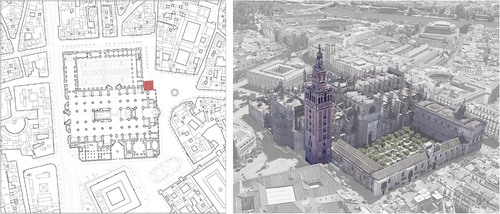
Figure 1. Localisation of the Giralda tower of the Cathedral of Seville.
The Giralda tower is the best-preserved element of the old mosque (), of which the tower is an independent architectural body. It has great importance due to its localisation and its symbolic characteristics. The tower was built in several construction phases, which were very distant in time and different in architectural style. Due to that, it is important to analyse the settlements taking into account these construction phases.
An accurate 3D FEM has been carried out for the settlement tower analysis using the FEM software PLAXIS 3D v20 (Bentley Systems Citation2020a). The geotechnical model and the foundation tower have been modelled. Furthermore, the analysis has been done bearing in mind the different construction phases of the tower.
The analysis and prediction of damage that can be caused by the differential settlements in masonry buildings is an important issue in the behaviour and retrofitting analysis of this type of structures (Giardina et al. Citation2020). Other works analyse the behaviour of the masonry buildings under the effect of different types of settlements and soils (Ferlisi et al. Citation2020), such as soft soils (Peduto et al. Citation2019). After an exhaustive search of similar works, a lack of studies about the soil, the foundation and the historical settlements of heritage buildings has been noted. The analysis of the damage caused by historical settlements (Micelli and Cascardi Citation2020) and the incidence of the soil in this type of buildings is necessary (Ivorra et al. Citation2010). In the analysis of the structural behaviour of these buildings it is important to bear in mind account the historical movements of the foundations in order to detect future damage and vulnerabilities. These buildings have generally had several constructions phases which have caused movement in the foundation due to load increases.
Many research works have just investigated the structural behaviour of heritage buildings, using different structural analysis methods (Malcata et al. Citation2020), where the non-linear analysis method and two-modelled method were used to evaluate the results of two softwares. Most of these studies have focused on the assessment of the seismic behaviour of these buildings (Degli Abbati et al. Citation2019) (D’Ayala and Paganoni Citation2011). Very few have applied the soil-structure interaction for this analysis (de Silva et al. Citation2015). In (de Silva, et al. Citation2018a) a non-linear static (push-over) analysis was applied in the model which considered the soil and the boundary conditions of the building. Then, the results were compared with a non-linear dynamic analysis taking into account the soil-foundation interaction. In (de Silva et al. Citation2018b), several types of interaction (surrounding buildings and soil-structure) were analysed comparing numerical models with in-situ dynamic surveys. In that work, the soil model was simplified by means of springs, simulating the soil-foundation impedance. Also, some previous studies worked on the structural assessment of the heritage bell towers (Milani and Clementi Citation2019)(Hadzima-Nyarko, Mišetić, and Morić Citation2017). Furthermore, other studies were centred on the characterisation of the buildings’ materials (Pineda Citation2016). In this study, an increase in the fundamental period of the structure owing to the structural material was identified. It therefore analysed the utilisation of traditional materials in order to optimise future repair works. It can be observed that there is abundant research concerning structural and soil-structure interaction for heritage buildings. However, to the author´s knowledge, there are not many studies that analyse in detail the foundation and its behaviour for heritage buildings.
In this research, several previous works about the case study building and the nearby area have been used to carry out an accurate definition of the geotechnical model, the foundation, the construction phases and the boundary conditions. According to the definition of the geotechnical model, several works performed at the base of the tower (Barrios-Padura et al. Citation1997a) (Barrios-Padura, Barrios-Sevilla, García-Navarro Citation2012) and in the nearby area (Diz-Mellado et al. Citation2021) have been used. A thorough and proper characterisation of the tower foundation has been done taking into account the different historical hypothesis (Rodriguez-Pérez Citation1988), borehole studies (Vorsevi Citation1988) and the archaeological campaigns (1996–1998) (Tabales-Rodríguez et al. Citation1996, Citation1998). In addition, the different modifications that the buildings have undergone over time have been considered, based on the studies realised and the literature published (Jiménez-Martín Citation2007, Citation1998Citation2018).
The main objective of this manuscript is to obtain and to analyse the foundation historical settlements of the Giralda tower bearing in mind several important aspects. An accurate definition of the geotechnical model and its foundation have therefore been performed. In this respect, an accurate 3D FEM of the foundation and its background has been carried out. In addition, several important construction phases have been defined to accurately analyse the foundation movements. The consolidation time between the different phases has also been defined, being an important factor to take into account for this building. Then, the 3D FEM model has been compared with the results in previous works and in-situ vertical measurements of the tower. Finally, the calculations were conducted using two different soil models (Mohr-Coulomb (MC) and Soft-soils (SS)), comparing both results.
The paper is structured as follows. First, the methodology used to determine and to analyse the settlements of the tower and to evaluate the possible differential settlements are described. Afterwards, an accurate definition of the case study building and its background are presented. Then, the results of the different soil models with different background conditions are shown.
2. Material and method
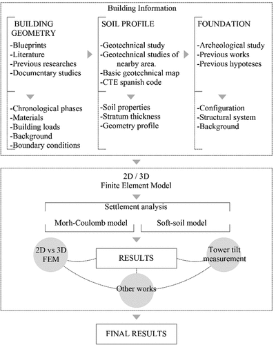
In this section the methodology of this manuscript is presented. It has been summarised in .
Figure 2. Schematic diagram of the methodology.
First, the data and previous research about the building, its foundation and the sub-soil setting has been collected considering previous works (Barrios-Padura, Barrios-Sevilla and García-Navarro Citation2012)(Barrios-Padura et al. Citation1997b).
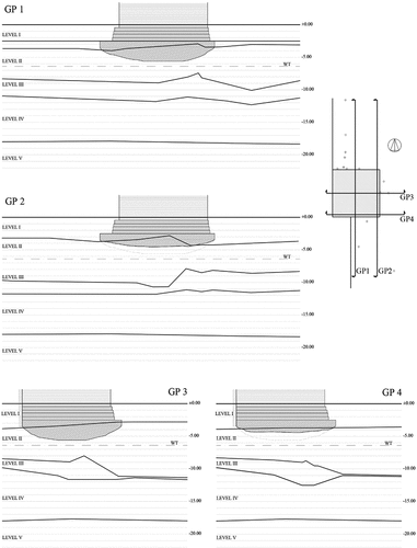
Second, a characterisation of the soil under the tower has been performed in order to obtain the depth of each layer and its geotechnical properties. Accordingly, an accurate definition of the subsoil profile has been done bearing in mind several geotechnical works concerning the base of the building and its surroundings. In this regard, the different strata of the geotechnical model under the tower have been accurately drawn in a 3D model based on the boreholes carried out in the base of the building. The surface of each layer has thus been defined through a point cloud. After that, four typical geotechnical profiles in 2D have been defined in order to better analyse the depth changes in each layer around the south-east corner and in the centre of the tower. To this aim, the commercial software Autodesk Civil3D (Autodesk, Inc Citation2020) has been used. The tower foundation has also been included in these profiles () in order to analyse its depth and the localisation of the irregularities of the strata in relation to it.
The geomorphology and of the geotechnical properties of the soil composing each layer have been analysed. The information has been mainly obtained from the geotechnical campaign executed in 1988 where eight boreholes were executed at the tower base (Vorsevi Citation1988). This study includes information of the laboratory tests of the samples which were extracted in this geotechnical campaign. With those data, the geotechnical properties have been compared with other boreholes performed in the nearby area, the Spanish code CTE DB-C (Ministerio de Fomento Citation2007), the basic geotechnical maps of Seville (Soler Arias et al.Citation2005) and the archaeological campaigns (1996–1998) (Tabales-Rodríguez et al. Citation1996, Citation1998).
A precise definition of the building foundation has been conducted considering several previous hypotheses and research works. These first hypotheses have been compared and completed with geotechnical works and archaeological campaigns in the base of the case study building. In the foundation model has thus been inserted in the different geotechnical profiles to assess the relationship with the important layer irregularities.
In order to perform a thorough calculation of the settlements, the most important construction phases have been defined based on several modifications that the building has undergone through its history. Considering these modifications is relevant for the model and the calculations, as the tower weight has substantially increased through the different periods. It also affected the foundation and its movements. Therefore, the execution time of each phase and the time of non-construction between them have also been considered. The cohesive layer has been modelled with undrained properties in order to assess the settlement caused by the consolidation effects. Afterwards, the loads and the boundary condition of each phase have been determined.
The deformation and stability of the foundation have been analysed using PLAXIS 3D v20 (Bentley Systems Citation2020a), which is a FEM software used to analyse the deformation and stability of geotechnical problems. In the case of the 3D FEM, the soil has been defined in the software through the definition of several boreholes, where the depth of each layer and the water table are specified. The base of mortar can be also considered in the schematic profile because it is an essential aspect in the composition of the tower’s foundation. Finally, the different construction phases have been defined according to the calculation phases in the software. For each of them, the pressure applied, its length and the time between phases has been considered to calculate the consolidation settlements.
In order to define the behaviour of the soil in the FEM, two models have been considered in the analysis of the foundation settlements. First, the Mohr-Coulomb model (Labuz and Zang Citation2012), which is an elastic perfectly-plastic model. The behaviour of the foundation has been taken into account to model and to obtain a first estimation of the tower’s settlement. The computation time is short due to the consideration of a constant average stiffness of the soil layer. This model requires five parameters in order to define the behaviour of the soil: two stiffness parameters (Effective Young’s modulus and Effective Poisson’s ratio) and three strength parameters (Effective cohesion, effective friction angle and dilatancy angle). These parameters are obtained from a basic laboratory test of soil samples.
Second, the Soft Soil model (SS) (Bentley Systems Citation2020b) has been used to do a more accurate analysis. This method is used for the analysis of soils such as normally consolidated clays, which can be found in the geotechnical model under the tower. The volumetric strain in this model is considered in the formulation of the compression and the swelling lines. To this effect the parameters of stiffness are defined by the modified compression index (λ*) and the modified swelling index (k*). These indexes have been obtained in function of the compression (λ) and the swelling index (k), respectively. Parameters obtained from the oedometric test can also be employed: the compression index Cc, the swelling index Cs and the initial void ratio e0.
The results obtained in the 3D FEM have been compared with other previous works and with the recent measurements of the tower verticality (Barrios-Padura, Barrios-Sevilla and García-Navarro Citation2012). Therefore, the 3D FEM model can be evaluated and calibrated with other studies. As a consequence, accurate conclusions about the historical foundation settlements have been obtained.
3. Case study: the Giralda of Seville
During the Almohad period (1147–1248), Seville was considered the capital of Al-Andalus, especially in the epoch of the caliphs Abū Ya’qūb and his son Abū Yūsuf. The construction of the Major Mosque, which was started in 1172 by Almad ibn Bāsu, was considered the most important event regarding the religiosity of the city (Molins Citation1998). It was constructed on swampy ground due to the Guadalquivir riverbed passing through this area, where a group of buildings (houses, a chapel, markets and gardens) were built extramural during the Cordoba caliphate. These buildings were expropriated and demolished by the Almohads in order to build the Major Mosque. Ahmad ibn Bāsu ordered that the ground in this area be levelled by means of a mortar wedge, which ensured the stability and the regularity of the mosque (Jiménez-Martín Citation2007), due to the soil in this area sloping to the southeast. The remains of these buildings were found in the different archaeological projects carried out on the east side of the Cathedral and the Virgen de los Reyes square (Tabales-Rodríguez et al. Citation2002).
The redevelopment of the meridional sector started in 1169, where several military enclosures, a new layout of the Almoravid wall and the Tagarete riverbed were constructed. The construction of the major Mosque in the entrance to the Alcazaba started in 1172. The caliph Abū Ya’qūb inaugurated the mosque in 1182. The caliph enclosed the building in a wall, including the construction of the Alminar, where the walls were joined in 1184. Later, in 1198, the caliph Abū Ya’qūb Yūsuf ordered the conclusion of the tower with the four golden spheres (Yamur) (Jiménez-Martín Citation2007).
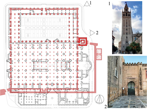
The Major Mosque had a dimension of 15,000 m2, composed of seventeen naves 5.46 m wide and 67.88 m long. The central nave was 7.01 m wide (). Its Alminar and its yard are the only parts of the old Islamic building currently preserved. The minaret (the Giralda tower) is the best element preserved, which conformed an autonomous architectural entity in the old mosque (Jiménez-Martín Citation2007) ().
Figure 3. Major mosque superimposed on the Gothic Cathedral floor (based on the hypothesis of A. Jimenez and A. Almagro). Photography of the Giralda tower (1) and the induced settlement on the Lagarto” gate (2).
The Giralda tower is the most symbolic building of Seville. It is a great example of the different cultures that have lived in the city throughout its history. Originally, it was built as a minaret for the Islamic main mosque of the city from 1184 to1198 during the Almohad period (1147–1248). It was the largest minaret built in the Islamic period compared to similar towers such as the Marrakesh and Rabat mosques. It should be noted that the Rabat mosque (Hassan Tower) was expected to be taller but it was not concluded (Jiménez-Martín Citation1998). The tower has undergone different construction phases and important modifications. The most relevant is the construction of the bell tower in the Renaissance by Hernán Ruiz in 1568. This construction was carried out 370 years after the conclusion of the Islamic minaret in 1198. Therefore, these two important works are very distant in time, form and style.
The cane of the tower, which belongs to the old minaret, was built with two parallel masonry walls. The plan has a quadratic dimension of 13.60 × 13.60 m and a height of 94.69 m (). The masonry walls thickness varies slightly from 2.00 m to 2.30 m. The interior cane has a dimension of 6.00 × 6.00 m, approximately, and its masonry walls have a thickness of 1.31 m. The wall is made of ceramic brick in its entire thickness; it has not an infill of other materials in its interior. This was tested with the boreholes carried out in several levels of the wall in 1985. In the core of the tower, within the interior walls, there are several vaults. The connection between both canes is made through the ascent ramps. These ramps are composed of solid ceramic bricks (0.10 m thick) and compact limestone concrete (0.12 m and 0.17 m thick). The thickness of the ramps ranges from 1.10 to 1.40 m. At the moment, the tower has a slight inclination towards the south-east corner, which may be caused by the settlements of the foundation or by irregularities in the construction. It must be mentioned that, nowadays, this tilt of the tower is not continuously monitored and the inclination data were obtained from previous works (Barrios-Padura, Fernández-Vélez and Martínez-Girón Citation1997c). Finally, it is important to highlight that the weight of the tower has caused induced settlements in the Cathedral, which can be visible in the “Lagarto” gate ( (2)).
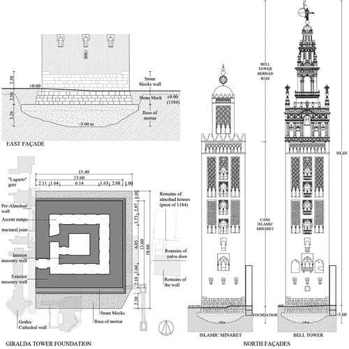
Figure 4. Giralda tower foundation, east façade elevation and plan (based on the archaeological studies carried out by Tabales (Tabales Rodríguez 1998)). North elevation of the Islamic minaret of the Major Mosque (based on the hypothesis of A. Almagro (Almagro-Gorbea and Zúñiga-Urbano Citation2007)(Almagro-Gorbea Citation2012)). Dimensions in metres.
3.1. Foundation of the giralda tower
The Giralda tower foundation has been defined according to several previous works carried out in the area. In this regard, the first foundation hypothesis, which was made in 1988 (Rodríguez-Pérez Citation1988), based on the boreholes drilled in the tower’s base, has been considered. This has been completed with the foundation study carried out in 1997 (Barrios-Padura, Fernández-Vélez and Martínez-Girón Citation1997c) (Barrios et al. Citation1997b) and the archaeological study made in 1998 in the base of the tower (Tabales-Rodríguez et al. Citation1998). The latter performed several surveys at the base in the south, north and east façades of the tower, producing a great definition of the foundation and its background.
The boreholes carried out in the area and the analysis of them have provided a sequence of human actions in the tower’s nearby area. The level of the different occupation phases oscillates between −3 and −5 m (Roman period) and −3 and −2 m (initial Islamic levels) and from −2 m and the current elevation for the Almohad levels.
The excavation of the foundation carried out has an inverted cone shape and was made in two phases. The first one had steeper walls than the second one. The excavation reached depths of −3.00 to −3.50 m in the first phase and −5.50 m to −6.00 m in second. In agreement with some hypotheses (Jiménez-Martin and Cabeza-Méndez Citation1988)(Tabales-Rodríguezet al. Citation1998), once the excavation was performed, it was filled in by adding mortar up to −2.50 m. This was carried out due to the possible presence of water: a superficial water table or a confined aquifer.
The base of the tower is a 0.85 deep foundation slab in the north face and 1.10–1.50 m deep in the south face (). It is important to highlight that the leaned boreholes (Barrios-Padura, Fernández-Vélez and Martínez-Girón Citation1997c), which were carried out in the tower’s base in 1988, confirmed that the mortar base has a larger depth in the centre. It has a thickness of around 3.00 m in the centre of the tower, reaching −5.60 m deep. It should be mentioned that the old mosque was over a fill, which was fully removed in the base of the Tower, when constructing its foundation. The remains of a sectioned Almohad building were located in the east façade (Tabales-Rodriguéz et al. Citation1996) ().
Figure 5. Giralda tower foundation, south and north façade elevation (based on the archaeological studies carried out by Tabales (Tabales-Rodríguez Citation1998)).
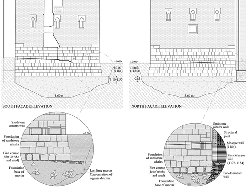
The slab is composed of mortar made of lime, sand, Islamic and Roman ceramic bricks, fragments of ceramic vessels, fragments of stone blocks, etc. (Tabales-Rodríguez et al. Citation1998). It has also been enlarged 1.00 m to the east and to the north and 2.30 m to the south. However, to the west, it has been attached over two pre-existing walls (one pre-Almohad (Emiral) and other of the Mosque, earlier than 1184) () (Tabales-Rodríguez et al. Citation1998). Therefore this mortar base has a dimension of 18.60 m (north-south direction) and 15.40 m (east-west direction), with an area of 287 m2 () (Tabales-Rodríguez et al. Citation1998).
The mortar of the footing slab has lost lime due to the presence of a large concentration of organic detritus in the south façade. This is owing to the presence of septic tanks and sewer pipes of the XIII and XVIII Century (Tabales-Rodríguez et al. Citation1998). This has caused the loss of cohesion in the mortar of this area ().
The tower´s foundation is composed of four courses of sandstone ashlars, which have a height of 0.48–0.58 m (). The first course stands out 0.70 m with respect to the south façade. The other courses widen, with their depth being around 0.08–0.10 m each. The base reaches a depth of 2.50 m with regards to the current level. The first and the second course were carried out with bend, which was used as a levelling technique during the construction of the minaret. There is a course of ceramic bricks, which was used as a wedge to regularise the surface in the contact with the footing slab under the first course (Tabales-Rodríguez et al. Citation1998). It is important to highlight that the joint between stone blocks in the first course was executed with the use of ceramic bricks, mud and wood ribbons in order to have less rigidity ().
As can be seen in , the foundation has been attached over two pre-existing walls in the west façade. It was built against the existing Pre-Almohad wall and the first mosque wall (1176–1184) (). Accordingly, it is important to highlight that there is a joint between the tower and the old mosque, as it was built as a structurally independent building.
3.2. Phases and loads
Several historical phases have been defined in order to accurately simulate the different stages that the tower has undergone. In consequence, three relevant phases have been selected for the analysis (foundation and base construction/Islamic minaret/Renaissance bell tower). These match historical moments where its weight increased substantially. It is important to define the time of each construction phase and the length of the periods of non-construction in order to consider the settlements caused by the consolidation effects. Arabian construction was based on experimentation and it had had an extensive experience in Africa and Al-Andalus. For instance, the caliph of Marrakesh built the Alminar of the Alí mosque in two different phases with six years of non-construction, so that the foundation could settle. In the case of the Giralda tower, the construction of its foundation and its base was stopped for four years, between 1184 to 1188 with the same goal (Tabales-Rodríguez et al.Citation1998). Later, there was a period of non-construction of 360 years between the construction of the Islamic minaret and the renaissance bell tower. The following phases have been considered in the calculation:
P1. Construction of the foundation (−2.50 m) and its base (2.50 metres of stone blocks). This was finished in 1184.
P2. Phase of consolidation, which corresponds to the time between the foundation and the base of the minaret with sandstone. This took place between 1184 and 1188 (4 years).
P3. Construction of the Alminar, which was built with ceramic brick. This took place between 1188 and 1198 (10 years).
P4. Phase of consolidation, which corresponds to the time later than the construction of the Alminar. The phase of consolidation which corresponds to the periods of non-construction, which has a great importance in this building, has been taken into account as well. This stage corresponds to the time between the end of the Islamic minaret construction in 1198 and the beginning of the construction of the bell tower in 1558 (360 years).
P5. Construction of the bell tower, which took place from 1558 to 1568. It raised the total height of the tower to 94,69 m. This was finished in 1568.
P6. Phase of consolidation, which corresponds to the subsequent time of the construction of the Renaissance bell tower.
The load of each of the three phases has been determined from the specific weight of each material, which has been obtained from other works (Barrios-Padura, Barrios-Sevilla and García-Navarro Citation2012) and the Spanish code CTE-DB-SE-AE (Ministerio de Fomento Citation2009). In addition, due to their relevance, the weight of the bells (24,710 kg), of the Giraldillo (1 500 kg) and the four bronze lilies (1 200 kg) has been borne in mind. In , the pressure and the cumulative pressure of each construction phase has been calculated.
Table 1. Pressure applied to the base of the foundation for the construction phases.
3.3. Geotechnical model
Seville is placed on recent alluvial materials from the Quaternary. These were transported by the Guadalquivir river and they were put on the Guadalquivir blue marls (Vázquez-Boza et al. Citation2015). The geotechnical model is composed of infill, sand, clay, gravel and marls (Soler Arias et al.).
The geotechnical model under the tower has been defined in (the ground levels correspond to the mean values of the bore tests carried out in the base of the tower and in the nearby area) and .
Table 2. Stratigraphy of the soil and layer thickness.
Figure 6. Geotechnical profiles (GP) under the tower. Dimensions in metres.
The physical and mechanical properties of the strata used for the calculations are listed in . These have been obtained from the geotechnical studies carried out on samples extracted from the boreholes drilled at the tower foot in 1988 (Barrios-Padura Fernández-Vélez and Martínez-Girón Citation1997c) and other boreholes drilled in the nearby area. In these geotechnical studies, several laboratory tests were carried out: Atterberg Limits, sieve analysis, unconfined compression strength, direct shear and oedometric tests. Furthermore, these data have been compared and completed with the archaeological study carried out in the area in 1996–1998 (Tabales-Rodríguez et al. Citation1996,Citation1998) , the Basic geotechnical maps of Seville (Soler Arias et al.), the Geological and Mining Institute of Spain (IGME) and the Spanish code CTE DB-SE-C (Ministerio de Fomento Citation2007). In addition, other research of the Giralda tower (Barrios-Padura, Barrios-Sevilla and García-Navarro Citation2012) and the nearby area (Barrios-Padura et al. Citation1997a) (Diz-Mellado et al. Citation2021) has been taken into consideration.
Table 3. Geotechnical properties of the strata.
The water table is at a depth of 6.00 m. Its depth changes according to the rainy season. The Guadalquivir river level also affects it. Due to that, its depth can change from 2.00–3.00 m to 9.00–10.00 m (Soler Arias et al.). In this work the water table have been considered at its average level.
The tower base is composed of mortar made of lime, sand, ceramic brick, fragments of vessels, fragments of stone blocks, etc. Its characteristics () have been determined according to other works (Barrios-Padura, Barrios-Sevilla and García-Navarro Citation2012) (Barrios-Padura et al. Citation1997a) and the Spanish code CTE-DB-C (Ministerio de Fomento Citation2007).
Table 4. Properties of the foundation base.
The accurate definition of the dimensions of the geotechnical model under the tower has been done taking into account the boreholes carried out in 1988, in the base of the tower. The top surface of each layer has been plotted through a point cloud, using the commercial software Autodesk Civil3D (Autodesk, Inc Citation2020). What is more, four 2D geotechnical profiles have been depicted in order to analyse the depth and the possible irregularities of each layer under the tower (). Two sections through the centre of the tower (N-S direction and E-W direction), and two under the south façade and east façade have thus been performed to analyse the geometry of the strata under the south-east corner of the tower, which presents the tilt (Barrios-Padura et al. Citation1997b). The profile of the tower foundation has also been inserted in these sections in order to accurately define its position.
It should be noted that the depth of the soft alluvial infill layer (Level II) is not uniform. It is 2.00–3.00 m thicker in the south-east corner of the tower. This is a soft layer which could have caused a larger settlement in this area. This layer has a heterogeneous composition with silty clay sand alternating with ceramic traces, ceramic brick traces and organic matter. In some zones there is a great content of organic matter, possibly caused by the presence of several cesspits of the old mosque (Tabales-Rodríguez et al. Citation1998).
4. Results and discussion
In this section, the most relevant results obtained from the calculations of the FEM models are shown and analysed. The settlements for each construction phase, considering the consolidation effects, are listed in . The results of both analyses (MC and SS models) are also presented. The settlements have been measured in five different points, which are located in the centre and under each corner of the foundation (). In order to evaluate the accuracy of the results, the different settlements in each point in the 3D FEM have been compared with other previous works and the real measurement of the verticality of the tower.
Table 5. Settlement for each point and construction phase. Results in centimetres.
Figure 7. Discretisation and measurement points of the 3D FEM.
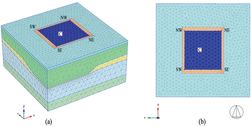
The 3D FEM has an area of 36 × 36 m and is 20 m deep (). The thickness of the different layers has been defined by means of several boreholes in the software. The depth of each layer has been determined by means of a cloud point as aforementioned. The FEM has been defined from the contact area between the stone blocks and the mortar base (−2.50 m level). The settlements have been measured in this level, where the foundation rests on the mortar base. The fill layer (up to 0.00 m level) has been defined as a superficial load. The tower foundation of four courses of sandstone ashlars has been defined by means of a plate. The tower foundation has been situated in the centre of the FEM. The cohesive strata (Levels II, III and V) have been defined with undrained conditions in order to analyse the movements caused by the consolidation effects.
It can be observed that the settlements are more uniform in the early phases. The largest increase of settlements is produced in the phase of the construction of the Islamic minaret (P3) and its consolidation phase (P4). This is in agreement with the big increase of the pressure applied (529.5 kPa) and the long time of consolidation (370 years). Finally, the settlements only increased in 2–4 cm with the construction of the bell tower (1568) and its consolidation (P5 and P6, respectively). It can also be noted that the settlements in the SS model are larger than the ones achieved in the MC model. These results are in accordance with the fact that the SS FEM is more accurate as it considers the compression index (Cc), the swelling index (CS) and the porosity (e0) of each layer. In this regard, it is expected that the deformation of the soft strata (Level II and III) will be more accurately calculated.
shows the total mesh displacement (uz) of the MC model in the section GP2 (south-north under the east façade) and GP4 (west-east under the south façade). These sections have been selected due to the larger depth of the soft strata. As can be seen, the settlement of the foundation is larger under the south-east corner (SE). In these sections the differential settlements are larger than in the central profiles. This is due to the irregularity of soft strata. The deformation, which is larger under the south-east corner, is similar in both.
Figure 8. Total mesh displacement of the MC model. Section GP2 (a) and GP4 (b).
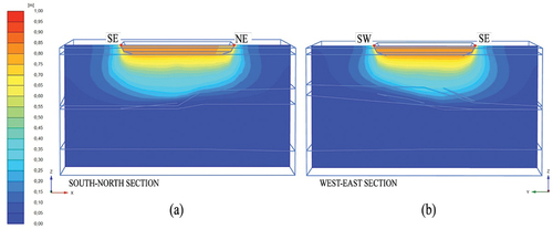
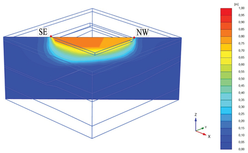
shows the total mesh displacement in a section from the south-east (SE) to the north-west (NW) corner. It can be observed that the settlement under the south-east corner is larger than the north-west corner. The tower has the largest settlement (−82.60 cm) under the south-east corner. This is due to an increase of 2.4 m in the depth of the soft layer (Level II) in that zone. It is important to highlight that the largest differential settlements have been obtained in this direction (NW to SE): 5.0 cm in the MC FEM () and 9.0 cm in the SS FEM (). This differential settlement coincides with the direction of the largest inclination measurement of the tower (Barrios-Padura, Fernández-Vélez and Martínez-GirónCitation1997c)(Barrios-Padura et al. Citation1997b).
Figure 9. Total displacement of the MC model. Section from the south-east to the north-west corner.
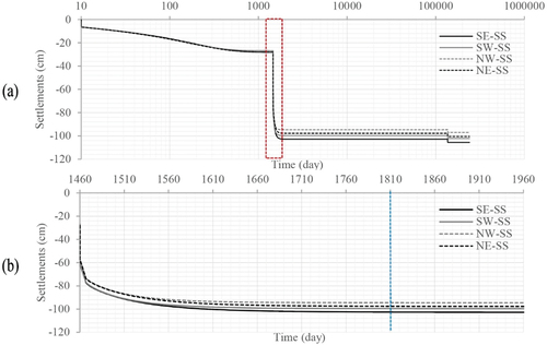
Also, the evolution of settlements in the four corners of the tower as a function of time are presented in for the MC model and in for the SS model. In that sense, the time has been plotted in a logarithmic scale in graphic (a), and the time has been plotted in linear scale in the construction (P3) and consolidation of the Alminar (P4) graphic (b). Generally, the largest settlements have been achieved for the P3 and P4 phases, which show the construction and consolidation of the Islamic Minaret. By contrast, the smallest settlements have been obtained for the Bell tower construction (P5 an P6 phases).
Figure 10. Settlements as a function of time (MC model) (a) All phases using a logarithmic scale (b) Enlargement plot of the construction and consolidation of the Alminar (P4 and P5). (SE, SW, NE and NW points).
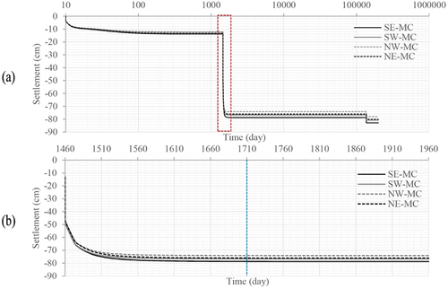
, shows that the foundation construction and its consolidation (4 years) caused a settlement of around 14 cm. The largest differential settlement was produced in the phase of construction and consolidation of the Islamic Minaret (P5 and P6) where the total settlement increased around 60 cm. The consolidation of the Minaret caused a settlement of 28 cm, which occurred in 8 months (). The largest differential settlement has been measured between SE (−82.6 cm) and NW (−77.6 cm), which is 5 cm. This is due to the thickness irregularity of the soft strata (Levels II and III), which increases by 2.40 m under the south-east corner (SE) with respect the north-west corner (NW).
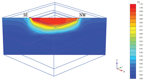
The total mesh displacement (uz) of the SS model in the north-south (a) section, the west-east (b) section under the east and south façade, respectively, and the south-east to the north-west corner section have been plotted in . In the SS model, the total displacements are greater than in the MC soil model (). In addition, the displacements are more irregular near the surface, as the deformation of the soft layer is more complex in the SS model. However, the largest vertical displacements have also been detected in the same points as for the MC model. The largest settlements have also been measured in Point SE (south-east corner).
Figure 11. Total displacement of Soft-Soil model. Section north-south (a) and section west-east (b).
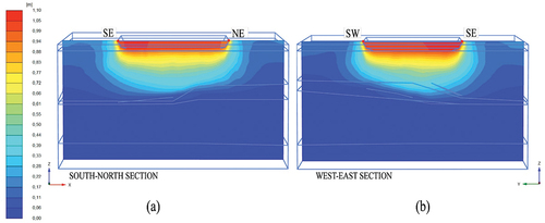
Figure 12. Total displacement for the SS model. Section from the south-east to the north-west corner.
The analysis of the evolution of settlements as a function of time in the SS model have been plotted in . As can be seen, the largest settlements are produced in the construction and its consolidation of the Islamic Minaret (P3 and P4) owing to these phases introducing the largest pressure increase. The consolidation of the Alminar construction (P4) caused settlements of 35 cm to 95–100 cm in a period of 12 months (), where the settlements remained constant at all points. There was a greater differential settlement in this phase, in which the largest differential settlement has been measured between the SE (−105.5 cm) and NW (−96.5 cm) corners, which was of 9 cm. This is due to the soft strata’s aforementioned thickness irregularity (Levels II and III). The settlement caused by the Bell tower construction was 4 cm and the differential settlements remained without changes.
Figure 13. Settlements as a function of time (SS model) (a) All phases using a logarithmic scale (b) Enlargement of the construction (P3) and consolidation of the Alminar (P4) (SE, SW, NE and NW points).
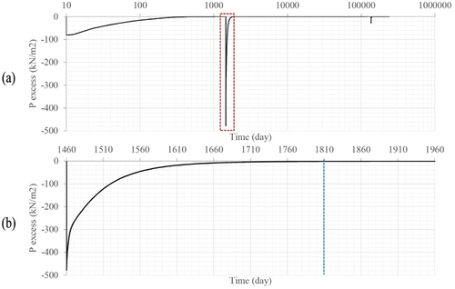
The pore pressure increased 75 kPa with the foundation construction (P1). This pressure is dissipated in a period of four years. Later, the greatest increase in pore pressure was obtained with the minaret construction (P3), where it increased to 478 kPa. This pore pressure was dissipated in a period of 12 months (). Finally, the construction of the Bell tower (P5) caused an increase on pore pressure of 28 kPa, which was dissipated in 7 months. This fact shows that the ground had already been consolidated.
Figure 14. Evolution of the pore pressure excess (KN/m2) measured at an intermediate point of the infill alluvial layer (Level II). (a) All phases using a logarithmic scale (b) Enlargement of the construction (P3) and consolidation of the Alminar (P4).
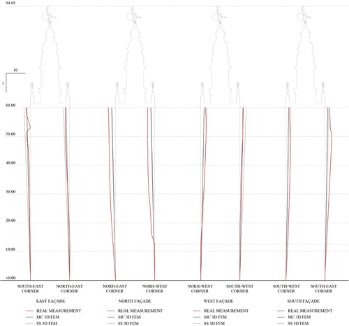
The comparison between the real measurement of verticality (Barrios-Padura et al. Citation1997b) and the different inclinations caused by the differential settlement has been plotted in . The differential settlements of the foundation cause a similar inclination in the tower compared to the real verticality measurement. As can be seen in , the east façade the MC 3D FEM are the one that best fit the real verticality measurement of the tower. In the case of the west façade, the SS 3D FEM shows the best fit for the north-west corner. Contrariwise, the MC 3D FEM is the best fit in the south-west corner (point SW). Furthermore, the SS 3D FEM are the most similar ones to the real values in the south façade. The largest difference in the inclination has been detected in the north façade. This deviation in some of the models might be caused because of the margin of error in the calculation models and the construction irregularities of the tower. There is also a lack of boreholes around the north-east corner, which would be necessary to more precisely define the thickness of the soft layer in this area.
Figure 15. Comparison between the real measurements of the verticality and the inclinations caused by the differential settlements.
5. Conclusions
In this research, the settlements of the Giralda tower have been studied, taking into account its different constructions phases. To do so, the MC and the SS in a 3DFEM have been calculated. For this aim, the tower foundation has been accurately defined in order to properly model the FEM. Thus, the following conclusions were drawn:
The analysis of the historical settlements is an important previous stage in refurbishment works in architectural heritage buildings. Specifically, it must be highlighted that there are many Islamic towers around the world. The Marrakesh and the Rabat towers are the most relevant (Jiménez-Martín Citation2018). Also, there are also significant towers built on soft soil, such as the Islamic tower of the Cordoba Mosque. Thus, the methodology carried out in this work can also be applied to the conservation and prevention analyses of these heritage towers, in order to understand the historical movements and possible damage. Furthermore, it must be noted that this work provides an important contribution to the structural analysis and future works of conservation concerning the Giralda tower, which has an Outstanding Universal Value according to the UNESCO.
The geotechnical profile under the tower presents two soft strata (Level II and Level III). These strata have some irregularity regarding their thickness. The Level II increases its depth by 2.50 m under the south-east corner of the tower.
The largest settlements in both soil models were due to the soft layer under the foundation of the tower, which have a large thickness. These strata (Levels II and III) have a very low elastic modulus (E), 5,428 kPa and 6,165 kPa, respectively. However, the differential settlements were caused by the irregular depth of the soft layer (level II), which increases its thickness by 2.50 m around the south-east corner. Due to this fact, the largest settlements were obtained in the south-east corner (Point SE) for all the soil models.
Comparing the results for both analyses, it can be observed that, for all the calculations, the vertical displacements were always larger in the SS, compared to those achieved for the MC. This is due to the fact that the definition of the soft strata (Levels II and III) is more accurate in the SS than in the MC, bearing in mind the compression index (Cc), the swelling index (CS) and the porosity (e0) of each layer.
In the foundation construction and its consolidations (P1 and P2) the differential settlement is smaller than in the minaret construction and its consolidation (P3 and P4). Accordingly, the largest increase of settlements has been obtained in these phases. This may be caused by the larger increase of the pressure applied (529.5 Kpa) and the long consolidation time (370 years). In contrast, the differential settlement only increased by 3.0–4.0 cm with the construction of the bell tower and its consolidation (P5 and P6).
It has been mentioned before that the tower has a tilt to the south-east corner, which could be caused by the differential settlements in its foundation, which attains its largest movements in the south-east corner. The tower inclination caused by the differential settlements is very similar to the real verticality measurements. However, as can be noted in , a small variation has been detected in the inclination obtained in some models. This could be due to construction irregularities and uncertainties in the FEM calculations (Barrios-Padura et al. Citation1997b).
According to the analysis, it can be stated that the load of the nearby Cathedral has a negligible effect on the settlements of the tower. It is important to highlight that that the loads of the Cathedral are smaller, more distributed and more superficial than the Giralda tower ones. In fact, it can be observed that the weight of the tower has caused induced settlements in the Cathedral, which are visible in the Lagarto gate ().
The ground has already been consolidated, as can be checked in the analysis of the evolution of settlements as a function in time and the analysis of the pore pressure. In that sense, the soil has dissipated all the pressures of the construction of the Bell Tower. In addition, more than 450 years have passed since its constructions.
In order to improve the uncertainties in the calculation, the author suggests several future works and research. In future geotechnical campaigns, new boreholes under the south façade and around the south-east and north-east should be carried out. These new boreholes are necessary in order to better define the soft strata properties (Level II and III) and to define the depth of these strata in detail. Therefore, it is necessary to carry out new laboratory tests on samples to obtain a new mechanical characterisation.
Acknowledgments
This work has been supported by FEDER_US-1380730 research project, entitled ”Proyecto para un patrimonio cultural resiliente a los terremotos. Casos de estudio: la Mezquita de Córdoba y la Giralda de Sevilla”. Romero-Sánchez, E. (author) wishes to acknowledge the financial support provided by the FPU Programme of Spain´s Ministry of Universities (FPU19/03597). The authors would like to thank the Cabildo Catedralicio of Seville.
Disclosure statement
No potential conflict of interest was reported by the author(s).
References
- Abbati, S., A. M. D’Altri, D. Ottonelli, G. Castellazzi, S. Cattari, S. de Miranda, and S. Lagomarsino. 2019. Seismic assessment of interacting structural units in complex historic masonry constructions by nonlinear static analyses. Computers & Structures 213:51–71. Elsevier Ltd. doi:10.1016/j.compstruc.2018.12.001.
- Almagro-Gorbea, A. 2012. Alminares de Al-Andalus y Al-Magrib. Laborarotiro de arqueología y arquitectura de la ciudad. Escuela de estudios Arabes, CSIC.
- Almagro-Gorbea, A., and J. I. Zúñiga-Urbano Escuela de estudios Árabes del CSIC . 2007. Atlas Arquitectónico de La Catedral de Sevilla. Sevilla - Granada: Cabildo de la Santa, Metropolitana y Patriarcal Iglesia Catedral de Sevilla 978-84-7170-213-5 . Escuela de.
- Autodesk, Inc California. 2020 AutoCad Civil3D.
- Barrios-Padura, A., F. Borja-Barrera, I. Valverde-Espinosa, A. Martínez-Girón, J. Polo-Velasco, A. Jiménez-Martín, and J. Barrios-Sevilla. 1997a. Estudio de La Cimentación de Los Pilares de La Catedral de Sevilla. Informes de La Construcción 48 (448):5–17. doi:10.3989/ic.1997.v48.i448.962.
- Barrios-Padura, A., I. Valverde-Espinosa, J. Polo-Velasco, M. A. FernándezVélez, and A. Matínez-Girón. 1997b. Caracterización de La Cimentación y Suelo Subyacente de La Giralda de Seville/España. Informes de La Construcción 49 (452):51–73. doi:10.3989/ic.1997.v49.i452.927.
- Barrios-Padura, A., J. Barrios-Sevilla, and J. García-Navarro. 2012. Settlement Predictions, Bearing Capacity and Safety Factor of Subsoil of Seville’s Giralda. International Journal of Architectural Heritage 6 (6):626–47. doi:10.1080/15583058.2011.594933.
- Barrios-Padura, A., M. A. Fernández-Vélez, and A. Martínez-Girón. 1997c Estudio sobre el reconocimiento getoécnico de la cimentación de la Giralda de Sevilla . .
- D’Ayala, D. F., and S. Paganoni. 2011. Assessment and Analysis of Damage in L’Aquila Historic City Centre after 6th April 2009. Bulletin of Earthquake Engineering 9 (1):81–104. doi:10.1007/s10518-010-9224-4.
- de Silva, F., F. Ceroni, S. Sica, M. RosariaPecce, and F. Silvestri. 2015. Effects of Soil-Foundation-Structure Interaction on the Seismic Behavior of Monumental Towers: The Case Study of the Carmine Bell Tower in Naples. Rivista Italiana Di Geotecnica 49 (3):7–27.
- de Silva, F., C. Ceroni, S. Sica, and F. Silvestri. 2018a. Non-Linear Analysis of the Carmine Bell Tower under Seismic Actions Accounting for Soil–Foundation–Structure Interaction. In Bulletin of Earthquake Engineering, Vol. 16. Springer Netherlands. doi:10.1007/s10518-017-0298-0.
- de Silva, F., D. Pitilakis, F. Ceroni, S. Sica, and F. Silvestri. 2018b. Experimental and Numerical Dynamic Identification of a Historic Masonry Bell Tower Accounting for Different Types of Interaction. Soil Dynamics and Earthquake Engineering 109:235–50. (November 2017). Elsevier Ltd. doi:10.1016/j.soildyn.2018.03.012.
- Diz-Mellado, Eduardo, E. J. Mascort-Albea, R. Romero-Hernández, C. Galán-Marín, C. Rivera-Gómez, J. Ruiz-Jaramillo, and A. Jaramillo-Morilla. 2021. Non-Destructive Testing and Finite Element Method Integrated Procedure for Heritage Diagnosis: The Seville Cathedral Case Study. Journal of Building Engineering 37. August 2020. doi:10.1016/j.jobe.2020.102134.
- Ferlisi, S., G. Nicodemo, D. Peduto, C. Negulescu, and G. Grandjean. 2020. Deterministic and Probabilistic Analyses of the 3D Response of Masonry Buildings to Imposed Settlement Troughs. Georisk 14(4):260–79. Taylor & Francis. doi:10.1080/17499518.2019.1658880.
- Giardina, G., A. Marini, P. Riva, and E. Giuriani. 2020. Analysis of a Scaled Stone Masonry Facade Subjected to Differential Settlements. International Journal of Architectural Heritage 14(10):1502–16. Taylor & Francis. doi:10.1080/15583058.2019.1617911.
- Hadzima-Nyarko, M., V. Mišetić, and D. Morić. 2017. Seismic Vulnerability Assessment of an Old Historical Masonry Building in Osijek, Croatia, Using Damage Index. Journal of Cultural Heritage 28:140–50. doi:10.1016/j.culher.2017.05.012.
- Ivorra, S., F. J. Pallarés, J. M. Adam, and R. Tomás. 2010. An Evaluation of the Incidence of Soil Subsidence on the Dynamic Behaviour of a Gothic Bell Tower. Engineering Structures 32(8):2318–25. Elsevier Ltd. doi:10.1016/j.engstruct.2010.04.007.
- Jiménez-Martín, A. 1998. Notas Sobre El Alminar de La Aljama de Isbiltya. In VIII Centenario de La Giralda (1198-1998) (Córdoba: Caja Sur, Obra Social y Cultural. Universidad de Sevilla.), 31–43 84-7959-229-X.
- Jiménez-Martín, A. 2007. Notas Sobre La Mezquita Mayor de La Sevilla Almohade. Antigrama (22):99–122.
- Jiménez-Martín, A. 2018 Tres torres en la vida de IbnʿArabī Ibn'Arabi y su epoca. (Editorial Universidad de Sevilla):97–122.
- Jimenez-Martin, A., and M. Cabeza-Méndez. 1988. Turris fortissima: Documentos sobre la construcción, acrecentamiento y restauración de la Giralda (Sevilla: Colegio Oficial de Aparejadores y Arquitectos Técnicos de Sevilla)197 84-404-3343-3.
- Labuz, J. F., and A. Zang. 2012. Mohr–Coulomb Failure Criterion. Rock Mechanics and Rock Engineering 45 (6):975–79. doi:10.1007/s00603-012-0281-7.
- Malcata, M., M. Ponte, S. Tiberti, R. Bento, and G. Milani. 2020. Failure Analysis of a Portuguese Cultural Heritage Masterpiece: Bonet Building in Sintra. Engineering Failure Analysis 115(May):104636. Elsevier. doi:10.1016/j.engfailanal.2020.104636.
- Micelli, F., and A. Cascardi. 2020. Structural Assessment and Seismic Analysis of a 14th Century Masonry Tower. Engineering Failure Analysis 107:104198. September 2019). Elsevier. doi:10.1016/j.engfailanal.2019.104198.
- Milani, G., and F. Clementi. 2019 Advanced Seismic Assessment of Four Masonry Bell Towers in Italy after Operational Modal Analysis (OMA) Identification . . In International Journal of Architectural Heritage, 1–30. . doi:10.1080/15583058.2019.1697768.
- Ministerio de Fomento. 2007. Documento Básico de Seguridad Estructural Cimientos (DB-SE-C) Código Técnico de la Edificación . España.
- Ministerio de Fomento. 2009. Documento Básico de Seguridad Estructural Acciones de la Edificación (SE-AE) Código Técnico de la Edificación . Spanish Technical Building Code.
- Molins, M. J. V. 1998. “La Ciudad Almohade de Sevilla.” In VIII Centenario de La Giralda ( 1198-1998), 15–30.
- Peduto, D., M. Korff, G. Nicodemo, A. Marchese, and S. Ferlisi. 2019. Empirical Fragility Curves for Settlement-Affected Buildings: Analysis of Different Intensity Parameters for Seven Hundred Masonry Buildings in The Netherlands. Soils and Foundations 59(2):380–97. Japanese Geotechnical Society. doi:10.1016/j.sandf.2018.12.009.
- Pineda, P. 2016. Collapse and Upgrading Mechanisms Associated to the Structural Materials of a Deteriorated Masonry Tower. Nonlinear Assessment under Different Damage and Loading Levels. Engineering Failure Analysis 63:72–93. Elsevier Inc. doi:10.1016/j.engfailanal.2016.02.013.
- Rodríguez-Pérez, P. 1988 La Giralda Enterrada, Últimas Investigaciones. Tvrris Fortissima. Documentos Sobre La Construcción, Acrecentamiento Y Restauración de La Giralda (Sevilla: Colegio Oficial de Aparejadores y Arquuitectos Técnicos de Sevilla) 167–83 84-404-3343-3 .
- Soler-Arias, E., Huete-Fuertes, R., Rodríguez-Liñán, C., Jaramillo-Morilla, A., Suárez-Samaniego, L., and Sanz-Cuesta, V. 2005 ITE Anejo I.2. Mapa Geotécnico Básico de La Ciudad de Sevilla (Colegio Oficial de Arquitectos de Sevilla : Fundacón Fidas) 84-933738-7-7
- Systems, B. 2020a. CONNECT Edition V20 PLAXIS 3D.
- Systems, B. 2020b. PLAXIS 2D Reference Manual CONNECT Edition V20. 10.1142/9789814343459_others04.
- Tabales-Rodríguez, M. A., A. S. Romo-Salas, E. García-Vargas , and R. Huarte-Cambra. 2002 Investigaciones arqueológicas en la acera de levante de la Catedral de Sevilla . . Magna Hispalensis I Recuperación de La Aljama Almohade (Granada: Aula Hernán Ruiz, Cabildo Metropolitano) 115–68 8471701839.
- Tabales-Rodríguez, M. Á., A. Salud-Romo, and E. García. 1998. Nuevos Avances En El Estudio Del Alminar (La Giralda). In VIII Centenario de La Giralda (Córdoba: Caja Sur, Obra Social y Cultural. Universidad de Sevilla.), (1198-1998), 109–127.
- Tabales-Rodríguez, M. A., E. García-Vargas, R. Huarte-Cambra, R. Huarte Cambra, and A. S. Romo-Salas. 1996. Intervención Arqueológica En El Acerado de Levante. Sevilla: Catedral de Sevilla.
- Tabales-Rodríguez, M. A. , Gacía-Vargas, E., Huarte-Cambra, R., Romo-Salas, A. S. 1998. Intervención Arqueológica En La Giralda 1998. Sevilla: .
- Tabales-Rodríguez, M. A., R. Huarte-Cambra, E. García-Vargas, and R. Romo-Salas. 2002. Estudio Arqueológico Del Basamento Pétreo y Cimientos de La Giralda. Excavaciones En La Cara Sur Del Alminar. In Magna Hispalensis I Recuperación de La Aljama Almohade (Granada: Aula Hernán Ruiz, Cabildo Metropolitano), 169–227 8471701839 .
- Vázquez-Boza, M., P. Durand-Leyra, A. Morales-Esteban, and J. L. de-Justo-Alpañés. 2015. La Marga Azul Del Guadalquivir. Sevilla: CIE Inversiones Editoriales DOSSAT 2000 978-84-941859-8-4 . 2000.
- Vorsevi, S. A. 1988. Laboratorio de Análisis Industriales. In Informe Sobre Sondeos, Análisis y Ensayos Getécnicos.