
 ?Mathematical formulae have been encoded as MathML and are displayed in this HTML version using MathJax in order to improve their display. Uncheck the box to turn MathJax off. This feature requires Javascript. Click on a formula to zoom.
ABSTRACT
The characterization of vernacular buildings is crucial for understanding the historical, social, and cultural significance of a community. These buildings reflect a collective memory and result from a long adaptation process to the local environment. Documenting them facilitates better decision-making regarding the preservation of their intrinsic values and long-term conservation. Unfortunately, depopulation processes in many areas threaten this invaluable heritage. Furthermore, this heritage is often overlooked due to a lack of awareness and appreciation by local authorities and residents. This paper presents a methodology for documenting and inventorying vernacular built heritage, with the main goal of contributing to promoting its valorization. The methodology integrates Information and Communication Technologies (ICT) with GIS tools to create large-scale inventories. Using the Montesinho Natural Park (Portugal) as a case study, the methodology facilitated the collection of data from over 2,000 buildings in 13 villages. The collected data was then used to characterize the vernacular built heritage of selected villages in terms of authenticity, conservation state, materials, construction systems, past interventions, present use, and occupancy. The findings of this study can serve as a valuable resource for developing inventories of vernacular buildings in rural areas, contributing to the protection of this distinctive architectural heritage.
1. Introduction
The conservation of vernacular heritage in rural areas requires a thoughtful and holistic approach. The singularity of this heritage rises from the interaction between the natural setting, culture, traditions, and identity of a specific region or community. The architecture resulting from this interaction is a testimony of a building typology that has developed over time in response to the local environment, climate, available resources, and the needs of the community. The knowledge to manage local resources was acquired by individuals through the iterative process of implementing and refining solutions over generations, which enabled them to overcome local limitations and develop customized solutions to meet their needs. This has facilitated the achievement of unique solutions that enhance environmental, social, and economic impact in different habitats (Fernandes Citation2012; Kolejka and Nováková Citation2023; Sardaro et al. Citation2021).
Many rural communities have struggled to maintain and conserve their vernacular heritage. This challenge has become greater over the past decades due to the depopulation phenomenon observed in numerous villages, which is associated with the decline of primary sector activities in those regions (Lekakis and Dragouni Citation2020; Ruiz Pulpón and Del Carmen Cañizares Ruiz Citation2020; Saxena et al. Citation2007). In situations where vernacular settlements are not preserved and valued by the local population, the built heritage is abandoned and neglected; in some other instances, a mischaracterization process occurs that favors modern architectural trends and industrial materials over traditional ones, leading to a progressive loss of local knowledge and skills (Fernandes Citation2012; Sardaro et al. Citation2021). This can be attributed to a widespread belief that vernacular constructions are inadequate for modern indoor comfort standards. Despite this, it has been identified that vernacular constructions hold considerable significance concerning sustainability. Indeed, according to (Avcı and Beyhan Citation2023; Homod et al. Citation2021), vernacular buildings can potentially guide contemporary architecture toward more sustainable practices by optimizing energy usage.
Overall, the conservation of vernacular architecture offers multiple advantages, playing an essential role in sustainable development and cultural preservation. By incorporating the intrinsic values of vernacular into contemporary architecture and urban planning, it is possible to create culturally rich and socially connected communities. However, for this conservation process to be successful, locals and other involved stakeholders must develop a comprehensive understanding and appreciation of the intrinsic values of this heritage.
Establishing the heritage values of vernacular architecture can pose a challenge due to the varying perspectives and interests of the stakeholders involved in their definition (Güler and Kâhya Citation2019). Therefore, it is crucial to gather comprehensive data and make it accessible to assist stakeholders in their decision-making process when establishing conservation policies for vernacular architecture.
In response to this need, the present work aims to introduce an inventory methodology that facilitate the screening of vernacular heritage in rural settlements susceptible to depopulation. This approach entails documenting different attributes of the built heritage regarding their materials, construction systems, type of use, abandonment, conservation level and type of interventions into an easily accessible diverse database. The methodology involves using Information and Communication Technologies (ICT) to collect data, which is then processed and stored in a GIS database to characterize the built environment of rural vernacular settlements. The methodology proposes the use of easily accessible tools, such as mobile phones and geomatics software, to catalogue and store information about a large number of buildings in vast rural heritage sites. The research hypothesis is that centralizing the information from scattered data sources will enable a better interpretation of these rural heritage sites and help in the formulation of conservation strategies at a regional level. Thus, ultimately, the suggested methodology can offer valuable insights into the development of management strategies and policies for the regeneration of this kind of settlement.
The Montesinho Natural Park (MNP), a vast natural region in the Portuguese territory with numerous vernacular settlements in an advanced state of depopulation, was here used as a pilot case study to test the implementation of the methodology. The analysis of the data collected during the process allowed for the characterization of the built heritage of a group of 13 villages, totalizing around 2,000 buildings. Additionally, a comprehensive understanding of the distinct built environment was gained, and context-specific conclusions regarding the current state of the vernacular architecture of the villages were drawn.
2. Documenting cultural heritage
2.1. The role of inventories
The process of inventorying culturally significant buildings aims to preserve a region’s architectural, cultural, and historical heritage of a region while also potentially contributing to a nation’s identity and memory. To safeguard their cultural identity, different countries have been developing extensive inventories to catalog and manage their heritage assets. To illustrate, there are over 1200 cultural assets in Switzerland inventoried as cultural properties of national significance (Swiss Federal Office of Culture Citation2023). The inventory is continuously updated and expanded, encompassing historic buildings, bridges, entire towns, and landscapes. The National Inventory of Architectural Heritage (NIAH) is a crucial entity in Ireland’s efforts to safeguard its architectural heritage (National Inventory of Architectural Heritage Citation2023). Among its primary functions is to conduct surveys and inventories of properties with cultural significance, such as houses, castles, industrial buildings, and vernacular architecture.
In the Portuguese context, in the 1960s, the national government financed a research project to value the local vernacular heritage. During the investigation, more than one hundred rural villages were surveyed. The findings were subsequently compiled in the publication “Arquitectura Popular em Portugal”, which includes descriptions, analyses, technical drawings, and photographs of the most representative vernacular buildings in each region of the Portuguese territory (Ordem dos Arquitetos Citation2004). This work has become an important reference in the study of Portuguese vernacular architecture and has served as a basis for numerous specialized research investigations in this field.
Inventories of cultural heritage assets also provide comprehensive information documentation, making them a valuable resource with a wide range of potential uses. The data collected from the inventories has immense potential as an educational resource. It can encourage people to take a greater interest in the uniqueness of culturally significant properties in a more engaging and straightforward manner (Martínez-Graña et al. Citation2022). In the Spanish context, Del Espino Hidalgo, Carrera Díaz, and Delgado Méndez (Citation2022) state that an inventory can be used as an effective tool for valuing a region’s vernacular heritage, resulting not only a tool for protection but also a mean for improving social cohesion and community participation. Inventories can also aid in comprehending the historical context of a site. The insights they offer can be used as groundwork for planning ongoing investigations, given that they can supply valuable information efficiently (Versaci et al. Citation2022).
Overall, cultural heritage inventories may play a crucial role in understanding, preserving, and promoting a nation’s cultural legacy by enabling people to appreciate the richness and significance of their heritage. They can enrich the learning experience, foster responsible stewardship, contribute to knowledge generation, guide decision-making processes, and promote the formulation of sustainable management policies to ensure the conservation of cultural heritage for generations to come.
2.2. Digital survey techniques
Nowadays, there is a growing need to inventory cultural heritage to promote its conservation, but it is often time-consuming and laborious, especially when it must be performed in remote locations and over a considerable number of buildings. This has led researchers to develop methods for expediting the inventory process while collecting a large amount of data. In recent years, digital tools and advanced survey techniques have played a leading role in the characterization and inventory of cultural heritage. One of the methodologies employed to characterize vernacular architecture uses the automatic detection of buildings via public satellite and aerial imagery. Monna et al. (Citation2021) applied a set of techniques based on machine learning on satellite imagery to document a vernacular village on Sumba Island, Indonesia. The process allowed them to identify more than 14,000 vernacular buildings and provided insight into their spatial distribution across the island. Wen et al. (Citation2023) have integrated remote sensing images with Convolutional Neural Networks (CNN) to identify the location of vernacular buildings and determine the surface area of their roofs. A similar approach has been used by Arashpour, Ngo, and Li (Citation2021) to automatically determine the physical characteristics of buildings, such as color and geometry.
Aerial photogrammetry and LiDAR are frequently employed for the purpose of surveying constructed large areas and evaluating the buildings’ materials and surrounding features (Ceccherini et al. Citation2023; Guo et al. Citation2023). The versatility and capacity to record extremely accurate data have made this type of surveying increasingly prevalent among researchers and professionals in the field of architectural heritage (Erenoglu, Akcay, and Erenoglu Citation2017; Jeong et al. Citation2020). The produced 3D models can afford a detailed account of a surveyed site, such as the physical characteristics of its buildings and their quantity, making it an accessible tool for data collection through inventorying (Guo et al. Citation2023; Xiao et al. Citation2023).
Besides the survey techniques mentioned above, ICT-enhanced methodologies can be implemented to obtain information regarding a heritage site, thereby expanding the potential for conducting digital inventorying. This process has already been applied in other areas, such as biology or education, and can be adapted for documenting cultural properties (Dudas, Rundgren, and Lundegård Citation2023; Faure-Beaulieu and Attwood Citation2022). When compared to traditional data acquisition methods such as note-taking and photography, ICT-enhanced can provide specific characteristics and attributes that were eventually missing during the site campaign, making them valuable for the office work stage (Yu Narkevich et al. Citation2021). In addition, it is important to note that the tools required for implementing ICT-enhanced methodologies are highly affordable, thus making the process widely accessible and even achievable with personal smartphones.
Researchers in western Spain used a digital inventory and Google Earth to create an ICT-enhanced project (Martínez-Graña et al. Citation2022). They included various layers of information such as geologic features, vegetation, cultural traces, and visual aids like pictures and graphs to make the information more appealing and easy to understand. The dissemination of the gathered information is facilitated through a 3D virtual pathway that allows users to explore geo-sites and interpret them using real-time supplementary information.
In a similar manner, an effort was made in Italy to document the water mills situated in a central region of Sicily, with the objective of preserving their authentic attributes as part of the vernacular legacy of Piazza Armerina (Versaci et al. Citation2022). The lack of accurate and centralized information regarding the ancient mills prompted a thorough investigation into bibliography, parish maps for inventory purposes, and on-site surveys. The methodology employed advanced image acquisition techniques to effectively fill in the gaps within the existing data. The outcome of the project led to the integration of a comprehensive database into the web platform of the Italian Government for the Ministry of Culture. This database contains all the collected data and is freely accessible on the internet.
To sum up, the process of inventorying is essential for the conservation and documentation of the world’s diverse cultural heritage, but poses difficult challenges. When addressing rural heritage sites that are widespread through large areas, the utilization of conventional on-site methods can lead to a process that requires a substantial amount of time and labor. The latest advancements in digital technologies and survey techniques, e.g., satellite and aerial imagery, enable researchers to collect vast amounts of data efficiently. These techniques have shown their effectiveness in characterizing and documenting cultural heritage sites. However, remote surveying techniques are still limited to provide general information, such as location, area and overall physical characteristics of buildings. The evaluation of essential aspects that characterize vernacular architecture, such as the physical condition of buildings, construction materials, construction detailing, interventions, occupancy level requires more thorough investigations that involve on-site inspections and even the engagement with local population. The proposed methodology tries to address these challenges by using a mixed approach combining ICT-enhanced on-site investigations and GIS tools with data post-processing and analysis at the office. Through implementing digital advancements, professionals and researchers can further enhance the understanding of cultural heritage, thereby safeguarding these invaluable assets for future generations and ensuring that shared heritage remains accessible and appreciated by all.
3. Methodology
In the scope of enhancing the value of the vernacular built heritage, an innovative documentation methodology is presented in this work. This methodology makes use of digital tools and allows to create extensive inventories of vernacular buildings in rural areas that are at risk of depopulation. It is important to highlight that the proposed methodology exclusively relies on visual assessment, resulting in the collection of data mainly related to the physical attributes of the vernacular buildings and their materials.
This methodology is designed to enable fast and extensive data collection during fieldwork by capturing videos and photos of the vernacular buildings, which are then registered after this process is complete. It also grants users the flexibility to define specific data parameters for analysis based on their individual needs. The lack of pre-established universal indexes enables a site-specific methodology for data analysis, taking into consideration the distinctiveness of each site, as the nature of vernacular architecture and depopulated settlements may vary significantly from site to site. The data in this methodology is gathered through a detailed survey. The various sections of the proposed survey are defined at the beginning of the project, enabling users to create a methodical collection of data for each village, which can be utilised either individually or for comparative analysis between vernacular settlements.
The analysis of the data collected during the process is intended for the characterization of the built heritage. Additionally, a comprehensive understanding of the distinct built environment intends to be gained, and context-specific conclusions regarding the current state of conservation of the vernacular architecture can be drawn. The proposed methodology is based on a systematic approach and is summarised in . Three phases comprise the development process: (1) Preliminary Work, (2) Fieldwork, and (3) Data Management.
Figure 1. Workflow diagram.
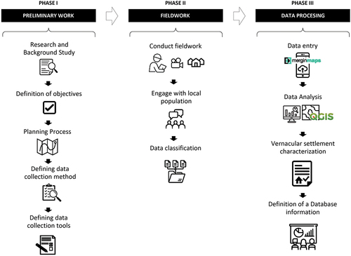
This methodology was implemented in 13 selected villages within the Montesinho Natural Park (MNP), a vast region in the Portuguese territory with numerous vernacular settlements in an advanced state of depopulation. It was used specifically to compare all surveyed villages in terms of quantity of vernacular buildings, architectural typologies, construction materials, current state of occupation, interventions and conservation level. It should be stressed that the presented methodology can be applied and tailored to investigate the specific particularities of vernacular settlements in other geographical locations. The activities shown in the workflow from should not vary among different contexts. However, the methods for collecting the data during the fieldwork in Phase II depends on the background study and definition of the objectives from Phase I. Similarly, in the event of integrating the proposed methodology with other data recording methods, it will be necessary to modify the “Preliminary Work” in order to accomplish the objectives of the “Fieldwork” phase.
3.1. Phase I: preliminary work
The initial stage of the methodology comprises a preliminary understanding of the site and planning the data collection campaign. The methodology starts with a systematic review of literature on aspects related to the existing local vernacular architecture, including but not limited to history, cultural significance, architectural styles, geography, economy, and construction systems, among others. This research activity is complemented by the review of physical and digital maps, old photographs, historical documents, and other available resources. Once the most significant elements of the study site are identified, the documentation objectives can be established. These objectives will lead to the planning process and the definition of the collection method and necessary tools.
The planning process involves creating a detailed outline to develop the site visits considering various factors such as logistics, budgeting, timing, and identifying specific locations or places to document. The data collection method to implement on-site is defined and discussed, being comprised of the following steps: (1) representation of the layout of the settlement’s buildings on a map, (2) codification of each building, (3) proposal of itineraries to follow on-site during the inventorying process, (4) definition of data collection tools, and (5) development of collection instruments such as checklists and documentation protocols for the data collection process.
Data collection tools are based on the use of digital equipment such as laptops, cell phones and digital cameras to record and play videos and photographs, as well as specialized software to register, store and manage data. Software tools should be chosen to allow: (1) the digitization of the survey forms, (2) a fast, easy, and efficient registration of the data, and (3) its subsequent integration with a geographic information system (GIS).
Finally, to ensure an effective data collection process, it is advisable to conduct a pilot test before implementing the tools on a larger scale to test the process’s feasibility and reliability. This also facilitates the elaboration of checklists and documentation protocols.
3.2. Phase II: fieldwork
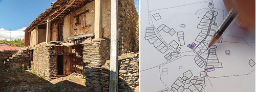
The second phase focuses on conducting detailed fieldwork within the rural settlements. This process involves the documentation of vernacular buildings through photos and videos. Prior to documenting, it is recommended to conduct a site inspection to determine key locations within the settlement, such as churches, squares, landmarks, rivers, roads, and other features. This is useful for orientation within the site and before starting the itineraries prepared in Phase I. However, these itineraries can be modified according to the configuration of the site, but it is important to leave a written record of the new itinerary on a plan to have greater clarity when registering the data in phase III. It is recommended to pinpoint the location and route to be followed in each video on the map during the documentation phase before proceeding with the recording of buildings. This will also aid in the data recording process in Phase III. Additionally, it is important to highlight any difference between the maps developed in Phase I and the present condition of the site. It is advisable to engage in interviews with locals as they can offer valuable insights into the historical context and cultural significance of buildings.
After the collection of data from the site, it can be stored and maintained in a cloud-based data storage system. This allows for its compilation and classification to enable online collaborative access.
3.3. Phase III: data processing
The last phase of the methodology is dedicated to post-site activities. The activity begins with data entry, where on-site videos and photographs captured during Phase II are examined and utilized to complete the survey form established in Phase I. The digitalized survey form is filled out using the software defined in Phase I for fast and efficient data registration. It is recommended to correct the digital maps during this activity to accurately represent the current situation of the site. Registration of each building is done in accordance with the codes assigned during Phase I.
The registered data is stored in a GIS database for its processing. The GIS tool facilitates a comprehensive and accessible visual representation, which provides a spatial understanding of the common patterns and unique features identified within the site under study. Finally, the information obtained can be used to characterize the built environment. In a subsequent phase, the definition of a database is encouraged, thereby data can be disseminated to additional stakeholders, such as local authorities, urban planners, and conservation organizations, to assist in the development of policies, strategies, and interventions that aim to preserve and revitalize vernacular buildings in depopulated settlements, as well as to provide information for future reference and research.
4. Survey of the vernacular built heritage of Montesinho Natural Park
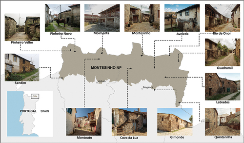
The Montesinho Natural Park (MNP) is an extensive protected area spanning around 75,000 hectares located in the north of the municipalities of Bragança and Vinhais, in the north-eastern part of Portugal (). It is renowned for its diverse natural environment, featuring schist and granite rock outcrops, plateaus, valleys, and a wide range of vegetation. With approximately 8,000 inhabitants and 88 villages (Da Alves and Da Silva Citation2012), the park reflects demographic patterns seen in other rural regions of southern Europe, including population decline, an aging population, and a considerable number of individuals with limited educational backgrounds (Silva, Sousa, and Albuquerque Citation2022). The park’s villages show a variety of architectural features that contribute to the cultural heritage, like bridges, churches, community ovens and forges, and water mills. In general, vernacular dwellings in the region showcase an architectural style characterized by two-story buildings with contiguous side walls and facades without front setbacks. Ground-floor spaces were originally used to accommodate commercial activities and rural utensils.
Figure 2. Montesinho Natural Park location highlighting surveyed villages with some representative examples of their vernacular architecture.
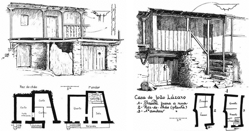
These vernacular villages were predominantly built using local material such as schist and granite for walls, stairs, and even columns to support the balconies (Simões et al. Citation2019). Wood is another widely used material, found in openings lintels, floors, balconies and roof structures (usually shared between a group of houses), mostly covered with slate stone tiles, locally known as “lousa”. The constructive system was influenced by the locally available materials and the owner’s financial monetary resources (Vaz et al. Citation2013). Dry joint stone masonry was the predominant technique employed, though buildings constructed stone and lime mortar can also be found ().
Figure 3. Representative architectural typology of vernacular houses from Rio de Onor village, in the Montesinho Natural Park, trás-os-montes region (Oliveira and Galhano Citation1992).
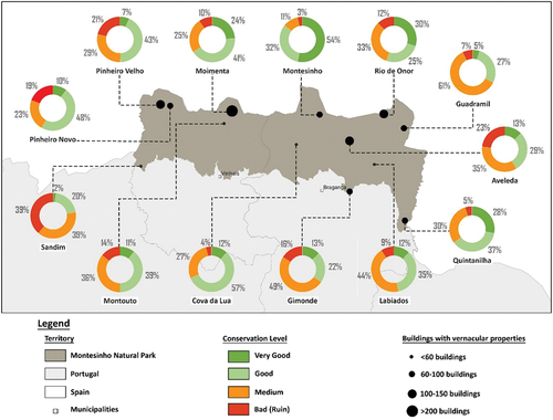
The arrival of industrialized materials and the decrease in traditional labour poses a threat to the vernacular architecture of the villages within the park. To understand the impact of the transformation process on the park’s vernacular settlements, the methodology proposed and presented in Section 3 () was implemented in the 13 villages highlighted in . A detailed explanation of the proposed methodology’s application is presented in the following sections.
4.1. Preliminary survey work
The main objective of the survey work carried out at the MNP was to characterize the present situation of the built vernacular heritage of selected villages within the park. Preliminary research has led to the identification of 13 villages that were considered the most adequate for documentation. They were selected based on their level of conservation, with a preference given to those that still have a significant number of vernacular buildings. The MNP villages are within the jurisdiction of Bragança and Vinhais municipalities. Bragança comprises the villages of Gimonde, Quintanilha, Guadramil, Rio de Onor, Labiados, Montesinho, Aveleda and Cova da Lua, whereas Moimenta, Montouto, Pinheiro Velho, Pinheiro Novo and Sandim are part of Vinhais. Following a preliminary visit to the park, the survey was structured to collect as much information as possible about the external configuration of the buildings. The identification of recurring patterns in the buildings made it feasible to narrow the data to be collected in the survey forms, in such a way that it could be filled as a checklist. This survey is divided into two parts: the first comprises basic information such as building ID, date, user, village name, and district; the second part contains more detailed data for the building characterization, such as the type of structural system, number of floors, openings, walls and roof materials, type of use, current state of occupation, conservation level, architectural condition, and façade typology ().
Figure 4. Applied survey form.
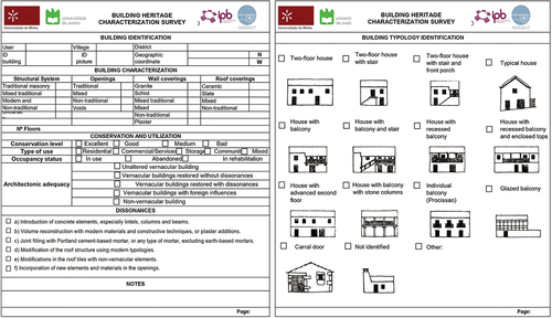
In the evaluation of the structural systems, five options were taken into consideration. These include “Traditional masonry” for buildings constructed with granite or schist, “Mixed traditional” for buildings consisting of traditional masonry and wood, “Modern and traditional” for masonry buildings with modern material interventions, “Non-traditional” for buildings made with concrete or steel, and “Uncertain” for buildings where the structural system could not be identified through visual inspection. Similar criteria were employed to characterize openings, walls, and roofing materials, ranging from ‘traditional’ to ‘non-traditional’ classifications, and in certain cases, specifying the material to achieve more detailed results.
The buildings were classified based on their intended use, which comprised ‘residential’, ’commercial’, ‘community’, ‘storage’, and ‘mixed-use’ categories. The occupancy status was determined through the valuable insights gathered from the external characteristics of the construction. For the assessment of the conservation level, a guideline was elaborated. In this guideline, four levels of conservation were taken into consideration, which vary from “very good” to “bad”. The parameters used to determine the levels were based on the structural integrity of the walls and the state of conservation of the roofs and other components of the building. Finally, the architectural condition was assessed according to the presence of interventions. Four categories were defined to describe this parameter: (1) Unaltered vernacular buildings, (2) Vernacular buildings restored without dissonances, (3) Vernacular buildings restored with dissonances, (4) Buildings with foreign influences.
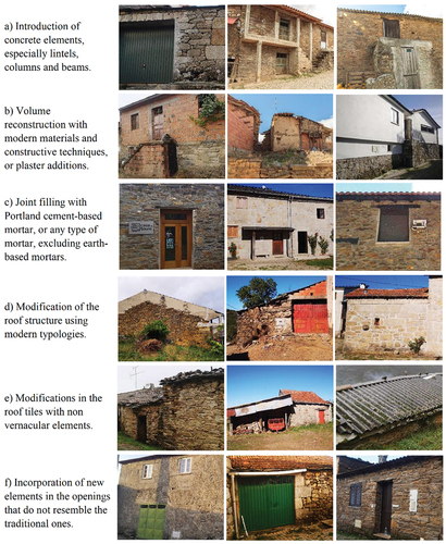
The term “dissonance” refers to a lack of harmony or coherence between the different elements of the building. In the context of vernacular architecture, which is constructed using traditional building practices and locally available materials, dissonances may arise when there is an irregular variation in the structural systems or materials employed within a building. The most common dissonances found in the buildings within the park are illustrated in .
Figure 5. Examples of the main “dissonances” found in Montesinho Natural Park buildings.
After a careful evaluation, the Mergin Maps application was selected as the data collection software (Dobias, Sab, and Petrik Citation2021). This application automatically captures and stores data in a database linked to an online account, allowing for convenient data exportation. The decision was reached after considering several factors, such as the user-friendly interface, compatibility across devices with different operative systems, the ability to engage multiple users simultaneously and the possibility of fast data entry. The GIS software selected was QGIS (QGIS Development Team Citation2021), which is free and open-source and integrates seamlessly with the Mergin Maps app. The process of digitizing the survey form was done using QGIS, and it was subsequently integrated with the Mergin Maps application. The maps of the villages were produced using CAD software, with only buildings and roads being represented.
The testing of the selected data acquisition tools, along with video and photo recording processes, resulted in the creation of guidelines to guarantee a uniform approach among the different researchers involved in the whole process.
4.2. Fieldwork
The initial phase of fieldwork for each village involved a preliminary reconnaissance. This made it possible to identify landmarks within the villages, which served as reference points during the recording process. The inspection method was applied, capturing videos throughout the entire process to gather information efficiently, particularly because of the reduced time during the inspection and the limited or unavailable internet connectivity on site. The itineraries were followed according to plan and documented on the map (). While conducting the itineraries, all the buildings were meticulously recorded in videos and photographs. Special attention was given to the building’s facades, roofs, architectural elements, and unique features. The total time dedicated to the inspection was six days.
Figure 6. Collection of information process.
Interviews were conducted with inhabitants encountered during the itinerary to gather important information about the village. This enabled the identification of significant vernacular buildings that were essential to the functioning of the villages in the past, such as water mills, forges, dovecotes, ovens, and others. After the data collection process was complete, the data was stored in a cloud-based storage system. It was structured in a manner that was both accessible and efficient for networking purposes.
4.3. Data processing
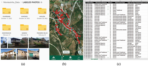
The data registration was done after fieldwork. During this phase, the videos and the photographs were carefully reviewed and all the data was registered in the Mergin maps app (Dobias, Sab, and Petrik Citation2021) (). By employing this app, it was possible to obtain the precise geographical location of every building on a digital map. Since some of the buildings in this case study shared the roof structure, it was decided to use points instead of polygons at first, to identify the buildings in the app. The accuracy of the buildings’ geometry was adjusted after the site inspections. The obtained plans were integrated into QGIS (QGIS Development Team Citation2021) with the database created in the Mergin Maps app.
Figure 7. Data processing steps: (a) organized data, (b) recorded points, (c) part of final database.
After the data was registered, it underwent a validation process to ensure that there were no errors, missing values, or inconsistencies. Finally, the data was analysed with the purpose of identifying patterns, trends, or insights that would allow to characterize the built environment of the MNP villages. The use of QGIS software enabled the visual presentation of results in maps. The most important results are presented and discussed in the following section.
5. Detailed analysis of processed data from MNP villages
Two thousand and six buildings distributed in thirteen villages of the Montesinho Natural Park (MNP) were surveyed using the proposed methodology. This methodology made it possible to gather relevant information regarding the physical condition of the buildings, including construction materials (walls, roofs, and openings), structural system, level of conservation, architectural condition, interventions, and façade typology. Additionally, it was feasible to assess a preliminary state of the occupancy level of the villages. By processing the raw data from the fieldwork campaign, the results have enabled to obtain an overview of the built heritage features of the villages in the Montesinho Natural Park (MNP). Ultimately, the results aim to provide a better understanding of the level of conservation of the vernacular heritage in the park to eventually support conservation management strategies of the site at a regional level.
The present section discusses the results regarding the preservation of the vernacular characteristics of the rural built environment of the villages, with a focus on analyzing the main interventions observed and the conservation level.
5.1. Buildings classification evaluation
The MNP’s vernacular buildings consists mainly of rural dwellings and small buildings used to support agriculture and livestock activities. These constructions are distinguished by their simple forms and the presence of stone staircases and wooden balconies attached to the main façade. Stone, wood, and earth are the most employed construction materials. The walls and exterior staircases are constructed using stone masonry (granite or schist), whereas slate tiles are utilized for roof covering. The construction of walls and staircases usually involved the use of dry-stone techniques, although, in some villages, lime mortar was used to bind the masonry. It is common for the stones to remain uncovered, although there are cases where a clay-based plaster has been employed. Timber is mostly used for floors, roofs, balconies and non-structural elements like doors, windows, and balustrades. In certain specific villages, the combination of earth and wood is utilized to construct the second floor, which is supported by stone walls and columns of the first floor.
The villages with the highest percentage of granite masonry buildings (58% to 78%) are Pinheiro Novo, Pinheiro Velho, Moimenta, and Montesinho, all of which are in the northern areas near Spain. Schist masonry walls, however, are primarily concentrated in Bragança, particularly in Rio de Onor, Aveleda, and Gimonde (57% to 72%). Sandim has the highest percentage of constructions built with traditional masonry, approximately 78%, followed by Pinheiro Velho and Pinheiro Novo, all situated in Vinhais municipality.
To examine the vernacular elements of the MNP’s villages that persist, it was important to initially distinguish between the buildings with vernacular elements and the non-vernacular buildings. Considering the varying interpretations of a building’s vernacular character (Asquith and Vellinga Citation2005), the vernacular nature of the MNP buildings in this analysis was defined based on Oliver’s Encyclopedia of Vernacular Architecture (Oliver, Citation1997). Specifically, the criteria outlined in the chapter dedicated to the vernacular architecture of the “Minho and Trás-Os-Montes” regions were adopted. Within this context, vernacular buildings of the MNP are defined as those that remain unaltered or have undergone interventions with non-traditional materials, yet still retain elements of local character in their physical composition while maintaining physical components of a locally construction tradition. The intention behind this is to set them apart from buildings that have a clear contemporary style and make use of a non-traditional structural system, such as reinforced concrete. The buildings with vernacular features were subsequently grouped into four categories based on how they keep their vernacular character: (1) unaltered, (2) restored without dissonances, (3) restored with dissonances, (4) influenced by foreign styles.
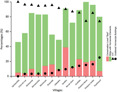
displays the results of the comparison between the number of buildings with vernacular elements and Non-Vernacular Buildings in each studied village. The results suggest that the villages near the city of Bragança show a large concentration of non-vernacular buildings. Specifically, Gimonde, Labiados, and Quintanilha exhibit more than 50% of non-vernacular buildings. The villages within the park’s interior and near the northern border with Spain presents higher percentages of buildings with vernacular features. In comparison to Bragança, the villages from the municipality of Vinhais have a greater percentage of vernacular constructions.
Figure 8. Building characterization in selected villages of the Montesinho Natural Park.
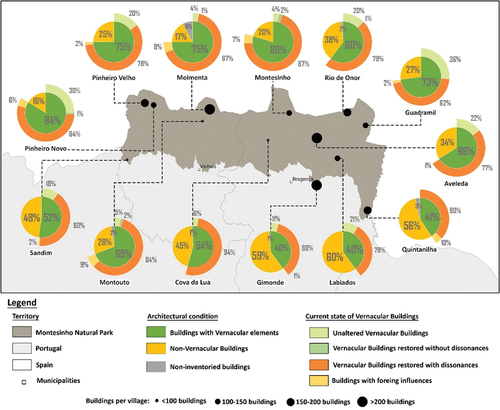
The villages of Pinheiro Novo, Pinheiro Velho and Guadramil are particularly noteworthy for their percentage of vernacular buildings. In these villages, there are more than 70% of buildings with vernacular features, with over 20% of them remaining unaltered. Pinheiro Novo is the village with the largest number of buildings with vernacular features (84%), 30% of which remain unaltered. Pinheiro Velho has 75% of buildings with vernacular features; 20% of these are unaltered vernacular buildings. Guadramil has the highest concentration of unaltered vernacular buildings of all inventoried villages (36%).
Both Moimenta and Montesinho are examples of villages where a substantial number of buildings have undergone significant interventions. Moimenta is notable for its vast array of buildings, totaling more than 300, of which 75% still maintain vernacular features. Out of the 100 to 150 buildings in Montesinho, 80% keep vernacular characteristics. However, most of the buildings have been intervened and show significant dissonances (87%).
The inventorying revealed that only a few vernacular buildings had been restored without dissonances (no more than 2% in certain villages). These buildings were only found in villages with over 65% of vernacular buildings, like Montesinho, Rio de Onor, Montouto and Pinheiro Novo.
5.2. Characterization of past interventions
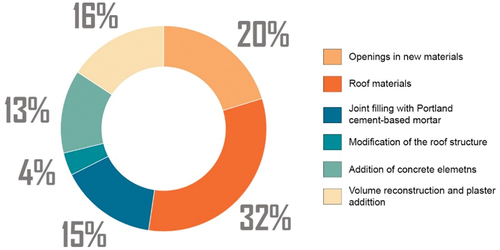
The implemented survey and inventory methodology allowed also to quantify and analyze the interventions carried out in vernacular buildings from the park’s villages. The most recurrent intervention is changing the roof materials, which was observed in 32% of the park’s intervened buildings (). This intervention is followed by changing the openings (windows and doors) using non-traditional materials, with a record of 20% of all interventions in the park’s selected villages. Roofs and openings are two construction elements very exposed to the environment, which contribute to its weathering. Moreover, the need to improve thermal efficiency and comfort can be considered a key factor behind the renovation of these elements, which are especially prone to weathering and therefore require frequent repair. From an economic perspective, the intervention of these elements are considered to be the most beneficial as a conservation measure to safeguard the physical integrity of the property. The addition of concrete elements, filling the masonry joints with cement-based mortar and volume reconstructions are interventions that account for similar percentages (13%, 15%, and 16%). Some of these interventions can change the structural behavior of the dwellings, which contributes to the loss of the structural authenticity of the intervened buildings and are generally implemented as part of a process of improving the comfort inside the houses. Finally, replacing the typical roof structure, including reconstruction of the gable walls or substitutions with concrete slabs, appears to be marginal (4%).
Figure 9. Distribution of the most recurrent architectural interventions in selected villages of the MNP.
5.3. Characterization of conservation level
The data gathered also gives an actual overview of the conservation level of the buildings with vernacular features in selected villages of the MNP (). It should be noted that one of the study’s limitations is that the inspection was carried out from the exterior of the buildings, which hinders the evaluation of the state of conservation. The establishment of the conservation level for each building was based on the following criteria:
Figure 10. Classification of the conservation level of the buildings with vernacular properties in selected villages.
Very good: Buildings that are well-maintained and show no signs of decay. This category fits mostly refurbished buildings.
Good: Buildings that show an aging process without any sign of pathology. This category also includes those plastered buildings that may be unpainted, as long as the building doesn’t show any visible structural damage. Minor non-structural elements like windows, doors and wood elements from balconies can be damaged or missing.
Medium: Buildings with an overall advanced state of aging and deterioration due to a lack of maintenance. These buildings display an advanced state of decay and long, visible cracks, but they are not in danger of collapsing. While the structural stability of these buildings remains uncompromised, non-structural elements such as wooden balconies, stairs, and openings are usually missing or heavily damaged. Buildings that have a representative area of the facades with a lack of plaster (>30%) are classified in this category, even if the missing plaster is not due to aging processes.
Bad: Buildings in an advanced state of decay. The damage ranges from partially collapsed buildings to completely ruined ones. Roof collapse is considered as well. These buildings usually present signs of abandonment.
The results show that certain villages have well-maintained buildings with vernacular features, with a combined total of more than 50% of these buildings classified as “good” and “very good”. Noteworthy is the case of Montesinho, with an 84%, followed by Cova da Lua (69%) Moimenta (65%) and Quintanilha (65%). The highest percentage of buildings with vernacular features rated as “very good” are found in Montesinho (58%), Rio de Onor (30%), Quintanilha (28%) and Moimenta (24%). All these villages lie along the MNP border with Spain.
However, there are some villages whose buildings with vernacular features are in an overall poor state of conservation, with a combined total of over 50% of these buildings classified as “bad” and “medium”. Sandim village is notable for its elevated percentage of vernacular buildings in poor conservation condition, with the categories “medium” and “bad” summing up to a total of 78% of all buildings. A similar situation is observed in Guadramil (68%), Gimonde (65%), Aveleda (58%) and Labiados (53%). Guadramil (61%) stands for the percentage of buildings in “medium” state of conservation, even though it only shows a small percentage of vernacular buildings classified as “bad” (7%). Gimonde (49%), Labiados (44%), Samdim (39%), Montouto (36%), Aveleda (35%) and Quintanilha (30%) also show a significant percentage of buildings in “medium” condition. Finally, Aveleda (23%), Pinheiro Velho (21%) and Pinheiro Novo (19%) reveal a significant proportion of vernacular buildings in a state of ruins (“bad” conservation level).
5.4. GIS database
The implementation of GIS facilitated the establishment of correlations between different data sets and enabled the representation of the results through maps. An example of correlated data is shown in , where the architectural condition of the buildings is compared with their level of conservation for the villages of Pinheiro Novo and Guadramil. In the first instance, the mapping of vernacular buildings allows for a visual representation of the historical layout of the villages. Additionally, the representation of non-vernacular buildings can provide a visual representation of the village’s evolution in recent times. In order to expand upon this analysis, a comprehensive understanding of the state of conservation of the historical layout of the villages can be achieved by representing the level of conservation of the various buildings that comprise it.
Figure 11. Correlation between the architectural condition and the conservation level for Pinheiro Novo and Guadramil.
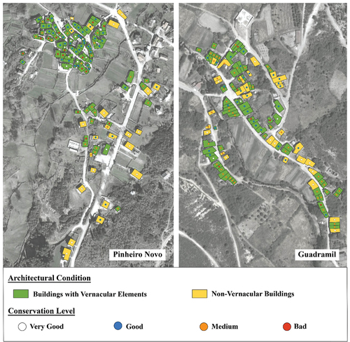
The outcomes indicate that vernacular buildings in Pinheiro Novo are still mainly situated in the core of the historic center, with urban growth spreading outward from this center. Additionally, the historical center shows a mixed conservation level of buildings, with some being in a “good” conservation state and others in a “bad” conservation state. Despite this, the data indicates that the historic center is in an overall good state of conservation. Meanwhile, the vernacular buildings located outside of this historical area are mostly in a “medium” state of conservation, in contrast to the non-vernacular buildings that present a “good” and “very good” level of conservation.
The results suggest that the urban layout of Guadramil has remained practically unchanged, as the newly established buildings have been erected over the location of a preexisting vernacular one. A distinct pattern is not evident in the distribution of the conservation level of the buildings, except for the classification of one side of the main street as being in a “good” level of conservation, and the vernacular buildings situated in the peripheries having a “medium” level of conservation. Moreover, the findings suggest that the village’s vernacular buildings have been conserved moderately.
5.5. Village transformation and abandonment relation
Determining a benchmark among the complex layers of transformation may not be straightforward, as the buildings in the villages may have been influenced by different architectural periods and modern construction methods that have merged into homogenization. Therefore, it is proposed to analyze the level of transformation of the villages by relating the Unaltered Vernacular Buildings (UVB) with buildings erected in typologies that are clearly outside this classification. Hence, a Village Transformation Index (VTI) is defined and used to quantify the level of transformation of a village. This index is calculated by determining the amount of non-vernacular buildings and transformed buildings in relation to the total number of buildings in the village, by using the following formula:
A second index, the Level of Abandonment (LoA) index, is also proposed to measure the level of abandonment of the MNP villages. This is calculated by dividing the abandoned buildings by the total number of buildings:
demonstrates a negative correlation between the Village Transformation Index (VTI) and the Level of Abandonment (LoA) among the 13 villages in the Montesinho Natural Park.
Figure 12. Correlation between the Village Transformation Index (VTI) and the abandonment of selected villages in the MNP.
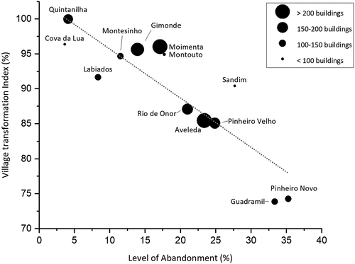
The results suggest that building interventions and new buildings may contribute to alleviating the condition of abandonment in vernacular settlements. This corresponds to expectations, as individuals who currently plan to occupy or intend to continue using the buildings, be it for brief or prolonged periods, express an elevated preference that mirrors contemporary needs. This heightened preference is evident in their desire for enhanced indoor thermal comfort, structural integrity, and an indication of social well-being. The cases of Guadramil and Pinheiro Novo are worth mentioning due to the similarity in their highest abandonment rates and lowest VTI percentages. They also share comparable characteristics as both constitute villages with over 70% of the buildings with vernacular elements and have between 100–150 buildings per village. There are also some notable traits that are worth highlighting among the villages of Rio de Onor, Pinheiro Velho, and Aveleda. Following Sandim village, Pinheiro Velho and Aveleda possess the largest quantity of buildings that have been categorized as “Bad” regarding their conservation level. Quintanilha and Cova da Lua, in contrast, display the highest VTI and are among the villages with the lowest number of buildings with vernacular elements classified as “Bad” in terms of conservation level (4–5%), as well as the lowest level of abandonment.
A comparison between the VTI and the Unaltered Vernacular Buildings reinforces the thesis that building interventions reduce abandonment rates at the cost of compromising the vernacular buildings’ authenticity (). The transformation process, to some extent, can be explained by the distance of the villages from major administrative cities (Bragança and Vinhais) It is worth mentioning that the villages located on the northern border with Spain display a higher percentage of buildings with vernacular features (Section 5.1). To reduce commuting time, people tend to settle in villages near cities, which often results in the adaptation of buildings to improve habitability standards. From a socioeconomic perspective, those residing in villages close to urban areas and in search of better employment prospects may have the financial capability to construct larger, more comfortable buildings with improved thermal comfort that align with their lifestyle. Socially, the idea that new and modern buildings continue to serve as a symbol of affluence and prosperity may persist as a driving force.
Figure 13. Village transformation index (%) versus unaltered vernacular buildings.
6. Final comments
A methodology for inventorying the built heritage of vernacular settlements was exposed. This methodology integrates different information and communication technologies (ICT) to produce a GIS-based database. The methodology is relatively straightforward, requiring minimal technological capital and skill investment for a task that yields preliminary findings from extensive data and large-scale area. It is a flexible tool that allows integration with other data recording methods, so it could be adapted to incorporate, for instance, photogrammetric surveys and deep learning algorithms.
This methodology made it possible to inventory more than 2,000 buildings distributed in 13 villages of the Montesinho Natural Park. With over 20,000 entries recorded, it provided a general assessment of the current state of the park’s buildings in terms of conservation level, use, abandonment, materiality, construction systems, interventions, and authenticity. It should be noted that one of the study’s limitations is that the inspection was conducted solely from the exterior of the buildings, which hinders the evaluation of the state of conservation and the occupancy status. In some cases, whether a building is occupied over the long term, short term, seasonally, or even abandoned is unclear. Furthermore, the structural system of the buildings cannot be easily identified, especially when it is covered with plastering materials (i.e., cement). These aspects require a more thorough investigation.
The findings indicate that a significant number of the MNP villages under investigation are threatened by an ongoing process of losing their architectural authenticity. Consequently, this results in the loss of both the material and the intangible values of the place, related to traditional construction skills and craftsmanship. Although most villages keep a high percentage of buildings with vernacular properties, the vast majority of these buildings, present interventions with dissonances. This condition leads to a loss of the heritage values of the villages, as well as their authenticity and integrity. However, there are still villages that keep a significant percentage of unaltered vernacular buildings, like Pinheiro Novo, Pinheiro Velho, Guadramil and Rio de Onor. While the vast majority of the MNP buildings preserve their original residential functionality, a significant number of them now serve as temporary residences, specially during the summer or holiday periods. Conservation strategies thus needs to address the complex issue of how to improve vernacular settlements, creating better living conditions while preserving the architectural authenticity and heritage values.
Characterizing vernacular buildings is a complex and interdisciplinary process, and collaborating with experts, local communities, and relevant authorities is often beneficial to ensure a comprehensive and well-informed analysis of the village’s built heritage. The proposed three-phase methodology aspires to contribute to providing an effective framework for assessing the loss of authenticity in vernacular architecture at a regional level. The results of this study can serve as a valuable resource to elaborate inventories of vernacular buildings in rural settlements prone to depopulation. Eventually, the data analysis can help to make informed decisions for safeguarding their unique architectural legacy.
6.1. Aknowledgements
This work was financed by National Funds through the Portuguese funding agency, FCT — Fundação para a Ciência e a Tecnologia, within the project INHAVIT, reference MTS/BRB/0086/2020, the PhD Grant 2021.07522.BD and the scholarship BI/DECivil/INHAVIT granted by University of Aveiro.
Disclosure statement
No potential conflict of interest was reported by the author(s).
Additional information
Funding
References
- Arashpour, M., T. Ngo, and H. Li. 2021. Scene understanding in construction and buildings using image processing methods: A comprehensive review and a case study. Journal of Building Engineering 33:101672. doi:10.1016/J.JOBE.2020.101672.
- Asquith, L., and M. Vellinga. Eds. 2005. Vernacular architecture in the 21st Century: Theory, education and practice. 1st. Taylor & Francis. 10.4324/9780203003862
- Avcı, A. B., and Ş. G. Beyhan. 2023. Revealing the climate-responsive strategies of traditional houses of Urla, İzmir. International Journal of Sustainable Building Technology and Urban Development 14 (1):18–34. doi:10.22712/susb.20230003.
- Ceccherini, G., M. Girardello, P. S. A. Beck, M. Migliavacca, G. Duveiller, G. Dubois, V. Avitabile, L. Battistella, J. I. Barredo, and A. Cescatti. 2023. Spaceborne LiDAR reveals the effectiveness of European Protected Areas in conserving forest height and vertical structure. Communications Earth & Environment 4 (1). doi: 10.1038/s43247-023-00758-w.
- Da Alves, R., and A. Da Silva. 2012. O Parque Natural De Montesinho E a Promoção Do Desenvolvimento Local.
- Del Espino Hidalgo, B., G. Carrera Díaz, and A. Delgado Méndez. 2022, September 15. Vernacular architecture and traditional trades. Social innovation and cultural heritage in rural Andalusia. doi:10.4995/heritage2022.2022.14278.
- Dobias, M., M. V. Sab, and P. Petrik. 2021. Mergin maps app (lutraconsulting/mergin: 2021.6.1). Zenodo. doi:10.5281/zenodo.6376045.
- Dudas, C., C. J. Rundgren, and I. Lundegård. 2023. Exploratory considerations in chemistry education—didactic modelling for complexity in students’ discussions. Science and Education 32 (2):481–98. doi:10.1007/s11191-021-00316-w.
- Erenoglu, R. C., O. Akcay, and O. Erenoglu. 2017. An UAS-assisted multi-sensor approach for 3D modeling and reconstruction of cultural heritage site. Journal of Cultural Heritage 26:79–90. doi:10.1016/J.CULHER.2017.02.007.
- Faure-Beaulieu, N., and C. G. Attwood. 2022. Remote video analysis of an unusual fish life-history combination: Nest-building, paternal care, and protogyny in a seabream. Environmental Biology of Fishes 105 (7):933–51. doi:10.1007/s10641-022-01303-y.
- Fernandes, J. E. P. (2012). O contributo da arquitectura vernacular portuguesa para a sustentabilidade dos edifícios [ Master Thesis, Universidade do Minho]. https://hdl.handle.net/1822/24769
- Güler, K., and Y. Kâhya. 2019. Developing an approach for conservation of abandoned rural settlements in Turkey. A/Z ITU Journal of the Faculty of Architecture 16 (1):97–115. doi:10.5505/itujfa.2019.48991.
- Guo, M., M. Sun, D. Pan, G. Wang, Y. Zhou, B. Yan, and Z. Fu. 2023. High-precision deformation analysis of yingxian wooden pagoda based on UAV image and terrestrial LiDAR point cloud. Heritage Science 11 (1). doi:10.1186/s40494-022-00833-z.
- Homod, R. Z., A. Almusaed, A. Almssad, M. K. Jaafar, M. Goodarzi, and K. S. M. Sahari. 2021. Effect of different building envelope materials on thermal comfort and air-conditioning energy savings: A case study in Basra city, Iraq. Journal of Energy Storage 34:101975. doi:10.1016/j.est.2020.101975.
- Jeong, G. Y., T. N. Nguyen, D. K. Tran, and T. B. H. Hoang. 2020. Applying unmanned aerial vehicle photogrammetry for measuring dimension of structural elements in traditional timber building. Measurement 153:107386. doi:10.1016/J.MEASUREMENT.2019.107386.
- Kolejka, J., and E. Nováková. 2023. Segments of the ancient cultural landscape in the “Hungarian corner” of Moravia: A valuable pre-industrial heritage. Hungarian Geographical Bulletin 72 (1):41–58. doi:10.15201/hungeobull.72.1.3.
- Lekakis, S., and M. Dragouni. 2020. Heritage in the making: Rural heritage and its mnemeiosis at Naxos island, Greece. Journal of Rural Studies 77:84–92. doi:10.1016/j.jrurstud.2020.04.021.
- Martínez-Graña, A. M., T. Díez, J. Á. González-Delgado, J. C. Gonzalo-Corral, and L. Merchán. 2022. Geological Heritage in the “arribes del duero” natural park (Western, Spain): A case study of introducing educational information via augmented reality and 3D virtual itineraries. Land 11 (11):1916. doi:10.3390/land11111916.
- Monna, F., T. Rolland, A. Denaire, N. Navarro, L. Granjon, R. Barbé, and C. Chateau-Smith. 2021. Deep learning to detect built cultural heritage from satellite imagery. - spatial distribution and size of vernacular houses in Sumba, Indonesia -. Journal of Cultural Heritage 52:171–83. doi:10.1016/J.CULHER.2021.10.004.
- National Inventory of Architectural Heritage. (2023, May). https://www.buildingsofireland.ie/
- Oliveira, E. V. D., and F. Galhano. 1992. I. Casa-Bloco, térrea e de andar. In Arquitectura tradicional portuguesa [en línea], Etnográfica Press. 10.4000/books.etnograficapress.6508
- Oliver, P. 1997. Encyclopedia of vernacular architecture of the world. Cambridge: Cambridge University Press.
- Ordem dos Arquitetos. 2004. Arquitetura Popular em Portugal, 4th ed., Lisbon, Portugal: AAVV.
- QGIS Development Team. 2021. QGIS geographic information system. Open Source Geospatial Foundation Project 1–2. https://qgis.org/.
- Ruiz Pulpón, Á. R., and M. Del Carmen Cañizares Ruiz. 2020. Enhancing the territorial heritage of declining rural areas in Spain: Towards integrating top-down and bottom-up approaches. Land 9 (7):216. doi:10.3390/land9070216.
- Sardaro, R., P. La Sala, G. De Pascale, and N. Faccilongo. 2021. The conservation of cultural heritage in rural areas: Stakeholder preferences regarding historical rural buildings in Apulia, southern Italy. Land Use Policy 109:109. doi:10.1016/j.landusepol.2021.105662.
- Saxena, G., G. Clark, T. Oliver, and B. Ilbery. 2007. Conceptualizing integrated rural tourism. Tourism Geographies 9 (4):347–70. doi:10.1080/14616680701647527.
- Silva, F. M., C. Sousa, and H. Albuquerque. 2022. Analytical Model for the development strategy of a low-density territory: The Montesinho Natural Park. Sustainability (Switzerland) 14 (7):4373. doi:10.3390/su14074373.
- Simões, R. N., I. Cabral, F. C. Barros, G. Carlos, M. Correia, B. Marques, and M. C. Guedes. 2019. Vernacular architecture in Portugal: Regional variations 55–91. doi: 10.1007/978-3-030-06185-2_4.
- Swiss Federal Office of Culture. (2023, May). Inventario federale degli insediamenti svizzeri da proteggere d’importanza nazionale ISOS e protezione degli insediamenti https://www.bak.admin.ch/bak/it/home/baukultur/isos-und-ortsbildschutz.html
- Vaz, A. J. F., D. Ferreira, E. Luso, and S. Fernandes (2013). Manual Biourb: Manual para a conservação e reabilitação da diversidade bioconstrutiva. https://bibliotecadigital.ipb.pt/handle/10198/9090
- Versaci, A., A. Cardaci, L. R. Fauzìa, and M. Russo. 2022. Cataloguing to maintain and preserve: New studies for the knowledge of the vernacular characters of the ancient water mills in central Sicily. September 15. 10.4995/heritage2022.2022.14926.
- Wen, B., F. Peng, Q. Yang, T. Lu, B. Bai, S. Wu, and F. Xu. 2023. Monitoring the green evolution of vernacular buildings based on deep learning and multi-temporal remote sensing images. Building Simulation 16 (2):151–68. doi:10.1007/s12273-022-0927-7.
- Xiao, W., H. Cao, M. Tang, Z. Zhang, and N. Chen. 2023. 3D urban object change detection from aerial and terrestrial point clouds: A review. International Journal of Applied Earth Observation and Geoinformation 118:103258. doi:10.1016/j.jag.2023.103258.
- Yu Narkevich, M., O. S. Logunova, P. I. Kalandarov, A. N. Kalitaev, G. V. Tokmazov, P. Yu Romanov, and O. Alimov. 2021. Results of a pilot experiment on monitoring the condition of buildings and structures using unmanned aerial vehicles. IOP Conference Series: Earth and Environmental Science 939 (1). doi: 10.1088/1755-1315/939/1/012030.