
ABSTRACT
River basins are difficult units to manage. Society is generally not organized on the basis of river basins, yet river basins are important units for society and vice versa. This paper discusses the development and effectiveness of river basin management, using the Great Ouse Basin in the east of England as an example. Because of conflicting interests between upstream and downstream areas in this basin, it took some 70 years, from 1850 to 1920, to establish the first basin-wide management body, and because of these interests this body was initially not very effective. Over the years management was scaled up until in 1989 a national rivers authority was established. A fundamental issue was the lack of a sense of community at the basin scale. This could have mitigated the conflicts of interests and facilitated better cooperation. The paper recommends more research on the role of community in river basin management and suggests to extend the notions of ‘institutional’ and ‘socio-ecological fit’ to include ‘community fit’.
1. Introduction
The argument in favour of river basin management is simple. River basins are coherent natural units that cross administrative boundaries. Within river basins, society and ecology, land and water, and upstream and downstream impact each other. To manage these interrelations effectively, a basin-wide and multi-sectoral approach is needed (e.g. Powell Citation1890, Downs et al. Citation1991, Barrow Citation1998, Jaspers Citation2003, Falkenmark et al. Citation2004, Parkes et al. Citation2010).
In practice river basin management has been interpreted in different ways and for different purposes: collaboratively or top-down, to promote conservation or development, etc. (Ghiotti Citation2007, Molle Citation2009). River basins are defined in terms of water flows and for managing water flows the river basin is a very relevant scale (Teclaff Citation1967). But it is not the only scale. Issues such as local flooding and pollution hotspots have a smaller geographical scope, whereas issues such as inter-basin water transfers and continental water recycling have a much larger scope (e.g. Hoekstra Citation2010, Van der Ent et al. Citation2010, Mostert Citation2015, Pande and Sivapalan Citation2016). Outside of the water sector the river basin scale often is not important at all. Sectors such as agriculture, town and country planning and energy supply depend on water and may impact water flows, but they are usually organized on the basis of administrative units rather than river basins (Ferreyra et al. Citation2008, Cohen and Davidson Citation2011, Sreeja et al. Citation2012).
River basin management can be defined as a form of natural resources management in which the river basin scale plays an important role. One way to realize this would be the establishment of river basin authorities with full responsibility for everything related to river basins. Such authorities could become very large and bureaucratic and coordination problems with existing authorities would be likely. Moreover, they are usually are not politically feasible because of opposition from existing authorities that would lose power (Mostert Citation1998, Biswas Citation2004). An alternative is polycentric river basin governance, in which responsibility is shared by a mix of general purpose government bodies and river basin organizations (Schlager and Blomquist Citation2008). This is the option chosen in many European countries to implement the EU Water Framework Directive (e.g. Junier and Mostert Citation2011, Liefferink et al. Citation2011, Moss Citation2012, Hovik and Hanssen Citation2016). There are, however, no blueprints for polycentric governance.
The aim of this paper is to shed more light on the development and effectiveness of river basin management, using the Great Ouse Basin in the east of England as an example. There is quite a lot of literature on this basin, but this literature deals almost exclusively with the downstream part of the basin, the Fens, and pays limited attention to governance issues (Summers Citation1973, Citation1976, Lindley Citation1982, Darby Citation1983, Hall and Coles Citation1994, Chisholm Citation2003, Citation2006, Citation2012). There is also a lot of literature on river basin management in England more generally, but this literature focuses on the more recent periods or on specific aspects or episodes (e.g. Richardson et al. Citation1978, Kinnersley Citation1988, Hassan Citation1998, Sheail Citation1998, Citation2002, Scrase and Sheate Citation2005, Penning-Rowsell and Johnson Citation2015, Purseglove Citation2015).
In this paper I will cover the period from the mid-nineteenth century, when the first ideas on river basin management were developed, to the present. Following up on previous work on the Netherlands (Mostert Citation2015, Citation2017), I will focus on the allocation of responsibilities, the discussions on this issue, and the role of different interests. Moreover, I will link the developments with the lack of ‘community’ or Gemeinschaft (Tönnies Citation1963) at the basin scale. The importance of community river basin management is sometimes mentioned or hinted at (e.g. Barham Citation2001, Ferreyra et al. Citation2008, Mohamad et al. Citation2015), but the issue deserves a more systematic discussion.
The paper is structured as follows. First, I will briefly introduce the Great Ouse Basin and describe the methodology used. Next, I will discuss the management of the basin until 1920 and the failed attempts to introduce river basin management in the second half of the nineteenth century. Following, I will discuss the functioning of the Great Ouse Drainage Board and Catchment Board, established in 1920 and 1930, respectively, and the further developments until the present. In the discussion section I will analyse these developments in terms of community and give recommendations for further research.
2. Materials and methods
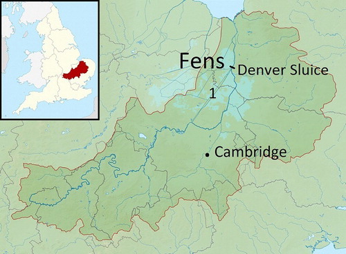
The Great Ouse is a river in the east of England, with a basin of 8380 km2 (Environment Agency Citation2008, see ). The downstream part of the basin lies in the Fens, a very flat and peaty area just above and partly under mean sea level (Hall and Coles Citation1994). In the seventeenth century large parts of the Fens were drained, which involved cutting two large cut-off channels, the Old and the New Bedford River, as well as many smaller drainage canals (Darby Citation1983). A side-effect of the drainage works was peat wastage. Currently, the rivers in the Fens run above the land surface, between embankments, and the land itself is artificially drained. More upstream in the basin there are a few medium-sized cities, such as Cambridge and Milton Keynes, but the Fens themselves have a primarily agricultural character. According to the National Farmers Union they contain about half of the grade 1 agricultural land, the most productive farmland, in England (NFU Citation2008).
Figure 1. Map of the Great Ouse Basin. 1 refers to the New Bedford River (left) and the Old Bedford River (right) (derived from Nifanion, Wikimedia Commons. Creative Commons Attribution-Share Alike 3.0 Unported license).
Most of the research for this paper was conducted from April to June 2016 during a sabbatical at Emmanuel College, Cambridge University. The research had an inductive and reflective character. Starting from a specific research interest, I focused on collecting and analysing relevant data, which in turn influenced my research interests and guided further data collection and analysis. Theory came in only gradually, to support the analysis. As discussed, my research interest was the development of the water management system, the allocation of responsibilities, the arguments used in the discussions on this, and the interests involved. Initially, I chose the Fens as a case study because of the similarities with the Netherlands, which would allow for interesting comparisons, but since the relation with upstream areas proved to be very important, my attention shifted to the basin scale.
The main data sources used were parliamentary papers, the Hansard, containing the transcripts of Parliamentary debates, and the minutes of different drainage authorities. The latter included the minutes of the Bedford Level Corporation 1860–1920, at the Cambridgeshire Archives; the minutes of the Great Ouse Drainage Board and successor bodies since 1920, also at the Cambridgeshire Archives; and the minutes of the Littleport & Downham internal drainage board since 1971, at the office of the Ely Group of Internal Drainage Boards. In addition, I conducted nine interviews with ten stakeholders in total. These included four (former) staff members of the Environment Agency, four representatives of Internal Drainage Boards, the chairperson and four members of the Great Ouse Flood Defence Committee, two county councillors, a former councillor of a district council, the head of the flood risk management team of Cambridgeshire, and a representative of the Royal Society for the Protection of Birds. (The total number is more than ten because many interviewees changed jobs or performed different functions at the same time).
3. Management until 1920
Before the seventeenth century, maintenance of the different waterways and embankments in the Great Ouse Basin was the responsibility of the individual land owners and occupiers. When responsibilities were not clear, the King could appoint commissioners of sewers, who could decide on liability and issue rates to finance maintenance and repairs. However, until 1833 they could not order new works and afterwards they could do so only if the owners and occupiers of three-quarters of the rateable land agreed (Kennedy and Sandars Citation1884).
The seventeenth century drainage of the Fens was executed by a consortium of ‘Adventurers’ (investors). They drained some 400,000 acres and in return received 83,000 acres. Maintenance of the drainage works was to be financed by means of rates on these 83,000 acres only. To administer everything, the Bedford Level Corporation was established in 1663 (Wells Citation1830).
In the eighteenth and nineteenth centuries the number of management bodies increased drastically. From 1727 onwards internal drainage boards for specific areas were established by Acts of Parliament to erect wind mills and rate the land that would benefit (Darby Citation1983). By 1920 there were 84 such boards (Land Drainage (Ouse) Provisional Order, 10 Geo. 4, first schedule). Moreover, the Bedford Level consisted of three parts, the North, the Middle, and the South Level. When major works were necessary that benefitted individual levels only, these works were funded and administered within the specific level, and in 1810 the Middle Level separated completely from the Bedford Level Corporation, followed by the North Level in 1857. Whenever major new works were required, the beneficiaries would be identified and separate boards would be established to administer the works and issue rates. On this basis boards were established for the Eau Brink project, a cut-off near the mouth of the Ouse (1795, 1821); for the straightening of parts of the Ouse in the South Level (1827–1830); for the Ouse Banks downstream of Denver Sluice (1837, seven boards in total); for improving Denver Sluice (1860); and for improving the Ouse Outfall (1915). Finally, river conservancies and statutory shipping companies were set up for parts of the Great Ouse and some of its tributaries. These built locks and maintained the navigation channel, financed from tolls (Summers Citation1973, Chisholm Citation2003).
The proliferation of management bodies made it hard to take concerted action. Each body had its own responsibilities and its own, often limited, funding sources, but to perform their function properly, they depended on each other. For example, at an inquiry held in 1914, the principal complaint of the authorities responsible for maintaining their own section of the channel was that there were shoals in the river below their section, so that it was useless for them to clear and deepen their own section (Grantham Citation1916). The situation was further complicated by the crisis since 1870 in agriculture, which raised most of the rates. Moreover, the income of the river conservancies and shipping companies dwindled as a result of the advent of the railways.
4. Failed attempts
The introduction of river basin management in the Great Ouse Basin was preceded by and accompanied with activities at the national level and in other basins. The first issue for which a river basin approach in England was advocated was salmon fisheries. Salmon fisheries require that the upstream spawning grounds are protected, and this is only likely if the upstream areas are allowed to benefit from their efforts and not all salmon is fished out of the river downstream. Recognizing these interdependencies, a select committee of the House of Commons recommended in 1825 that for each river in which salmon is found, a body of conservators should be established (House of Commons Citation1825). This was realized only in 1865 (MacLeod Citation1968).
The next issue for which a river basin approach was advocated was public health. As a consequence of the industrial revolution, the urban population had exploded and hygienic conditions in the slums were very bad. In 1847, a Royal Commission was set up to advise on the improvement of health in London, and in this context the issue of sewerage and discharge of the effluent was discussed. In its first report the Commission mentioned, almost as a matter of fact, that the whole of a natural drainage area should be under one jurisdiction because ‘it is impossible that improved works of systematic drainage can be carried out under arrangements that geographically divide the lines of watershed and the outfalls between separate and conflicting authorities’ (Metropolitan Sanitary Commission Citation1848, p. 49).
A similar recommendation was made in 1864 by the Select Committee of the House of Commons to inquire into Plans for dealing with Sewage. Boards for complete river basin should be established to control pollution, which should either take over or supervise the tasks of local government in this field (House of Commons Citation1864). There was also a link with drainage. In his testimony to the committee, H.C. Acland, Professor in Medicine in Oxford, attributed poor sanitary conditions not only to lack of sewerage, but also to waterlogging and to obstructions in the natural outflow of surface waters downstream. The only solution he saw was a general superintendence of the whole river basin (cf. Acland Citation1856).
In 1870 the former chairman of the Select Committee, Lord Robert Montagu, developed the idea of watershed boards further (Montagu Citation1871). They should be composed of representatives of local authorities and their tasks should include not only pollution control, but also fisheries, solid refuse, arterial drainage, reservoirs and water supply, and navigation. This would help to overcome upstream–downstream problems. Local authorities upstream were not expected to divert sewage onto land in the interest of the authorities downstream, and the authorities downstream were not expected to remove obstacles in the interest of drainage upstream, ‘but group together the interests above and below (and) unity will be concerned in all the works throughout the whole course of the river’ (Montagu Citation1871, pp. 344–345).
In 1877, following two years with serious flooding, the House of Lords established a select committee on Conservancy Boards for rivers (House of Lords Citation1877). According to most of the witnesses they had interviewed, flooding had increased as a result of improved field drainage upstream. There was almost unanimous agreement that river basins should be under a central river board, to prevent that improvements in one area increase problems downstream, but there was no agreement on rating. The key issue was whether the river boards should be funded by those benefitting from better flood protection only, or also by the uplands that use the river as their main drain and contribute to the flooding problems.
By 1879, the engineer Mr Lucas (Citation1879) could conclude that the idea river basin management had become generally accepted (see also CAWC Citation1943). This was, however, true in principle only. Initiatives to introduce river basin management were opposed not only in the upstream areas, but also in the Fens. At the time the problem of drainage was often seen as one of removing obstacles downstream in the interest of upstream (e.g. Locke et al. Citation1860, pp. 87–88, Land drainage act 1861, sect. 17–20, 72–83). In effect, land owners upstream of the Fens had actually requested this from the Bedford Level Corporation (Proceedings of the Bedford Level Corporation, 1874–1884, pp. 54–55, 84–91).
The first opposition from the Fens was against the County Administration Bill, introduced in Parliament on 28 January 1878. This bill would allow county boards to apply to the Local Government Board (a predecessor of the Department for Communities and Local Government) to become the conservators of a river, and to propose the repeal, alteration, or amendment of any local act interfering with the proposed system of management. On 4 May 1878, representatives from the Fens authorities had a memorial printed protesting against the bill. According to this memorial, the Fens should be protected against the interests of upstream areas and should continue to be under the conservation of the existing boards since flooding is a crucial issue for the Fens. Moreover, a conservancy board with upland members would be too remote and would lack both experience with and interest in the issue (Cambridgeshire Archives, Bedford Level Corporation, BLC, R59/31).
The County Administration Bill was not enacted, nor were the subsequent river conservancy bills of 1879, 1880, and 1883. The existing authorities in the Fens lobbied effectively against what they saw as ‘objectionable interference with existing authorities and also the unjust incidence of the taxation’ (Bedford Level Corporation, report book 3, p. 256). Their aim was to exclude the Fens from the working of the bills, and if this proved to be impossible, to consider the expenses that the different Fen authorities had already made for their own area (Bedford Level Corporation, report book 3, pp. 252–253) or to establish a separate conservancy board for the lower basin (Bedford Level Corporation, report book 3, p. 256).
The major issue for MPs from upstream areas was charging of the uplands that would not benefit anything. They argued that under common law the uplands were entitled to discharge their water and that field drainage did not increase flooding. Moreover, when the owners of uplands had bought their land, they could not have foreseen that it would ever be rated for the benefit of downstream. In addition, the current depression in agriculture would make it inopportune to impose extra burdens on land (e.g. Hansard Lords 22.4.1879 and 10.3.1881).
The main argument used in favour of charging uplands was that underdrainage did increase flooding and that therefore it would only be fair that the uplands contributed something (e.g. Hansard Lords 22.4.1879). But the most fundamental argument came from Mr Leake, Liberal MP for South Eastern Lancashire. He argued that the upland landowners had to contribute not because they increased flooding, but because they were members of a community: ‘The science of living in community demanded taxation over an extensive area, and the benefit derived from that taxation could never be appraised so that every man should equitably have his precise share’ (Hansard Commons 31.3.1881, col. 944).
5. The first river basin organizations
Apart from the failed introduction of Floods Prevention Bill in 1896 and again in 1897, 1898, and 1899, nothing much happened until the First World War, when an elected drainage board was established, the Lower Ouse Drainage Board. In effect, this board further complicated management (Mr Crocker in Diverse Citation1916, p. 274). It did not reduce the number of drainage authorities, nor did it execute major works for lack of funds. To remedy these problems, the Great Ouse Drainage Board was established in 1920.
The Great Ouse Drainage Board replaced 12 existing bodies and covered in principle the whole basin, but rating was limited to areas up to eight feet above the highest recorded flood level. This included 360,000 acres of fen land as well as 120,000 acres of upland river valleys. The rateable area was divided into a number of areas and subareas. Rateable land in each (sub)area had to pay a full rate for works within its own area, and a reduced rate for works in downstream areas. The Board itself consisted of 42 members: One appointed by each of the eight counties in the basin, one by the city of King’s Lynn, and 33 elected by the owners and occupiers of land in the different areas.
The establishment of the Board had been opposed in Parliament by representatives from the upstream counties. They challenged the notion that the upstream valleys had to pay for works being done downstream. They had always been free to discharge their water and they could not possibly benefit from the works downstream. Moreover, the 8 ft. contour line did not make any sense from an agricultural point of view. What it did was to lay the whole burden of the upstream area ‒ if there was one ‒ on 80,000 acres only. The results would be rates of more than one pound per acre (e.g. Hansard Commons 15.4.1920, col. 1933–1934). Solutions proposed were to have separate boards for the Fenland and for the area upstream, and to treat the main river downstream like a major highway, which were funded by Government.
The Board met for the first time on 28 October 1920 (Great Ouse River Division and predecessor authorities: Ouse Drainage Board, Minute book Vol. 1). Already before rates were levied, Board members from the upstream areas argued for revision of the Board (minutes 10.11.1921, p. 21). In 1922, the schedule of rateable lands had been finalized and the land owners and occupiers started to stir (e.g. minutes 25.05.1922, p. 32, 9.6.1922, pp. 57–59). Nonetheless, the Board decided to levy a rate to recover the expenses made until that date. Petitions against the rates started to stream in (minutes 30.11.1922, pp. 135–139) and many appeals against the rates were made (minutes 28.12.1922, p. 155, 29.3.1923, p. 205, 26.7.1923, p. 69). Many persons simply refused to pay the rates, including at least one Board member (J.P. Pentelow), and the Board had to start legal proceedings (minutes 29.3.1923).
In January 1925 about £40,000 of the two rates levied to date, more than one-third of the estimated revenue, still remained uncollected (MAF Citation1926). The Board had a bank overdraft of £66,855 6s 2d, which was dangerously close to the maximum overdraft set by the bank of £70,000 (minutes 15.1.1925, MAF Citation1926, p. 8). In addition, the Board had more than £100,000 of outstanding loans (MAF Citation1926, p. 32). It was clear that something had to be done.
Already in May 1922 a small committee had been set up by the Board, consisting of five members from the upstream areas and seven from the Fens, to propose changes (minutes 25.5.1922, p. 36). They came up with two different solutions: to exclude the upstream valleys from rating, which was favoured by representatives from these areas; and to extend rating to the whole basin, which was favoured by the representatives from the Fens (minutes 25.1.1923, pp. 176–177, 22.2.1923, pp. 193–194). In October 1923, the Board decided to ask the Minister of Agriculture and Flood for a Provisional Order that would exclude the upstream Area A – The Ouse valley upstream of the Fens – from rating and exonerate the Board from any works in the interest of the upstream areas unless these areas would contribute financially. In March and April the following year, the Ministry held an inquiry on the proposed Provisional Order. At the inquiry most time was taken up with the different views from the upstream areas and the Fens, but there was one point on which all agreed. This was that no satisfactory solution could be found unless Government was prepared to step in with a substantial financial contribution (MAF Citation1926, pp. 7–8).
The Minister decided to exclude Area A as a temporary solution and appointed a small commission to develop a more permanent solution. This commission estimated the costs of the necessary works to be £2.5 mln (MAF Citation1926). As to rating, the commission reflected that ‘the modern system of rating is generally based on the principle that local taxation must be borne by the community at large (…) in accordance with the assumed ability of the ratepayers to contribute (…)’. Moreover,
(m)any ratepayers derive no direct personal benefit from the expenditure of much of the local rates to which they are called upon to contribute, but as members of the community they pay towards all expenditure undertaken for the community as a whole. In such a matter as land drainage the whole catchment area may be looked upon as in some sense comprising a single community which cannot be artificially divided. (MAF Citation1926, pp. 16–17)
Following up on the commission’s report, the Minister started a second line of action: modifying the general law on land drainage for the whole of England and Wales. For this purpose a Royal Commission was set up on 26 March 1927. Three days earlier an Ouse Drainage Bill had been introduced in the House of Commons, but it was decided that the bill should not proceed before the Royal Commission had finished its report (Sheail Citation2002). This report was published in December (Royal Commission Citation1927). The Commission advised the establishment of a catchment area authority for all river basins with drainage issues. Two-thirds of the board members should be representatives of the local authorities in the basin ‒ County Councils and County Boroughs ‒ and one-third representatives of the internal drainage authorities or, where none existed, persons directly interested in the drainage of the lowlands. The catchment authorities would rate all land in the basin, including the higher lands, through precepts on the local authorities.
The Government adopted most of the recommendations of the Royal Commission, which ultimately resulted in the Land Drainage Act of 1930 (Dobson and Hull Citation1931). Under this act, 49 catchment boards were established, including one for the Great Ouse Basin, which replaced the Great Ouse Drainage Board. The 84 local drainage boards were reconstituted as internal drainage boards supervised by the catchment board. With respect to the ‘main rivers’, indicated as such on a map of the basin, the new catchment board got the exclusive power ‒ not the obligation ‒ to maintain or improve existing works and construct new ones. The costs were covered from precepts on the local authorities in the catchment area; from contributions by the internal drainage boards in the basin; and from government grants. Agriculture outside of the internal drainage boards did not contribute anything because in 1929 the productive industry, which included agriculture, had been exempted from paying local authority (council) tax.
The establishment of the Great Ouse Catchment Board seems to have improved the management of the Great Ouse Basin. Since precepts on local authorities had replaced direct rating, there were no problems anymore with collecting the rates. Moreover, in the minutes of the new catchment board there are hardly any signs of upstream–downstream conflicts. But appearances may be deceptive. In the memoirs of Heber G. Martin, vice-chairman of the new board, one can read that the county representatives on the board were against anything being done to improve drainage and flood protection because the Land Drainage Act had made them liable to help. One unnamed representative even would have said ‘what did it matter if the Fen was flooded’! Major works were undertaken only after major floods in 1937 and 1947 and after Government had made large grants available (excerpts in a bundle on the history of the Littleport & Downham IDB at the office of the Ely Group of IDBs).
6. Further developments
The Great Ouse Catchment Board dealt with flood protection and drainage only and not with water quality issues, largely because of opposition from the local authorities, which were responsible for pollution control (Hansard Commons 24.06.1930, col. 998, 1070–1071, Hassan Citation1998, p. 74). Yet, over the years the scope of the boards expanded. In 1937 the Joint Advisory Committee on River Pollution recommended multi-functional river boards, as did the Central Advisory Committee Water in 1943 (CAWC Citation1943, p. 68), and in 1947 Government introduced a bill to replace 53 catchment boards, some 1600 pollution authorities (47 in the Great Ouse Basin alone) and 45 fishery boards, by 29 new river boards. The bill was passed the next year, and eventually 34 river boards were set up, including the Great Ouse River Board (Box 1).
Box 1. River basin organizations in the Great Ouse Basin since 1920
1920: Great Ouse Drainage Board
Only areas up to 8 ft. above highest flood level
1931: Great Ouse Catchment Board
1948: Great Ouse River Board
Merger with the Ouse and Cam Fishery Board, in addition became responsible for pollution control
1963: Great Ouse River Authority
New task of licensing of and charging for abstractions
1974: Anglia Water Authority
Became also responsible for water services
1990: National Rivers Authority (Anglian region)
Lost water services task to privatized water industry
1996: Environment Agency (Anglian region)
Merger of the NRA with Her Majesty's Inspectorate of Pollution and the waste regulation authorities
Flood committees:
1974: Anglian land drainage committee and Great Ouse local land drainage committee
1990: Renamed Anglian Regional Flood Defence Committee and Great Ouse Local Flood Defence Committee
2005: Anglian (Central Region) Flood Defence Committee, replacing the regional and the local flood committee, with the same area as the local committee
2010: Renamed Anglian (Central Region) Regional Flood and Coastal Committee
Following the Rivers (Prevention of Pollution) Act of 1951, the river boards became responsible for licensing new effluent discharge outlets, and in 1961 this requirement was extended to outlets already existing in 1951. After the drought of 1959, the river boards got yet another task in 1963: licensing of and charging for abstractions. Their number was reduced to 29 and they were renamed ‘river authorities’. The 29 river authorities were replaced in 1974 by 10 water authorities, which took over the drinking water supply and sewage treatment tasks of the local authorities. Consequently, the water authorities became responsible for the whole water cycle, natural and artificial. The only exceptions were the areas of 28 statutory private water companies, which continued to supply drinking water.
In the Parliamentary discussions on these changes, two issues received a lot of attention. The first was the size of the new authorities: should they be relatively small so as not to lose ‘local knowledge and local keenness and pride’ (Hansard Lords 18.11.1947, col. 720), or large to achieve economies of scale with respect to personnel and to facilitate water transfers between areas? Over the years the size of the authorities did increase and eventually it exceeded the river basin scale, in the Great Ouse Basin in 1974. The second issue was representation of the different sectoral interests. Until 1983, when local government representation was abolished, the majority on the boards were local government representatives. In addition, however, there were appointees representing different sectoral interests, and there was often discussion whether to keep their number down, to prevent ‘unwieldy boards’, or to increase their number to facilitate broader representation (e.g. Hansard Lords 6.12.1962, col. 1052).
Sectoral interests were also behind the regional and local flood committees that were introduced in 1974 along with the regional water authorities. The initiative to establish regional water authorities had come from the Ministry of Housing and Local Government, who thought that water can be managed best from ‘source to tap’, on the basis of hydrological units. The Ministry of Agriculture, Food and Fisheries (MAFF) and the organized drainage interests – mostly agriculture – wanted to keep land drainage separate. The prospect of land drainage being financed from one water charge was attractive for agriculture as the costs would be spread over all water consumers, but it would also mean that the new water authorities would be in charge of the budget, and it would weaken MAFF’s claim to retain an interest in land drainage. MAFF and the drainage interests could not stop the establishment of regional water authorities, but they did manage to keep drainage and flood protection separate by introducing statutory land drainage committees. These had to approve the budget and the works programme for drainage and flood protection (Richardson et al. Citation1978).
In the late 1970s agricultural land drainage became very controversial because of the loss of wetlands. New drainage schemes required economic appraisal, but environmental damage was not taken into account and agricultural benefits were systematically overestimated (Bowers Citation1983). Agricultural land drainage was not a major issue in the Great Ouse Basin because most land had already been drained and land that had not was either owned by conservancy bodies or impossible to drain for technical reasons. However, the regional land drainage committee was involved in a famous controversy (the Halvergate marshes: Purseglove Citation2015). Moreover, the controversies led to changes in the composition of the local and regional drainage committees, and from the late 1980s onwards conservation interests were included as well.
Meanwhile, in 1989 the water services function of the regional water authorities was privatized under the conservative government of Margaret Thatcher. For the other functions, including drainage and flood protection, a national authority with regional branches was set up, the National Rivers Authority (Kinnersley Citation1988, Chapter 9, Hassan Citation1998, pp. 167–178). In 1996, the NRA was subsequently merged with Her Majesty’s Inspectorate of Pollution and the waste regulation authorities to form the Environment Agency.
The latest change is the Floods and water management act 2010, which gives local authorities (counties and unitary authorities) a coordinating role for local flood risks and transferred some of the supervisory powers over minor water courses to these authorities. These latest changes deserve, however, a separate treatment.
7. Discussion
The aim of this paper was to shed more light on the development and effectiveness of river basin management, which was defined as natural resources management in which the river basin scale plays an important role. The Great Ouse Basin provides several examples of the potential benefits of river basin management. Yet, because of conflicting interests it took several decades to introduce river basin management.
With the establishment of the Anglian Water Authority in 1974, the river basin scale was exceeded and in 1990 the first national water management authority was established, the National Rivers Authority. But the national level had been involved in water management for centuries, as regulator and since 1921 financially in the form of grants. Local and sectoral interests lobbied actively at the national level and they were also officially represented by their local MP. The national level was an arena rather than a separate sphere. The same can be said of the river basin level, most clearly in the period 1920–1930.
The Great Ouse Basin provides ample support for the theory that river basin management is political (Schlager and Blomquist Citation2008). Issues such as rating and representation on the different boards clearly affected ‘who gets what, when, how’ (Lasswell Citation1936). But river basin management is not only political. It is also about effective cooperation between the stakeholders to develop mutually satisfactory solutions, and about institutional arrangements that may promote such cooperation (Pahl-Wostl et al. Citation2007, Mostert et al. Citation2008). And it is about community, or the lack thereof.
The word community can be used in different ways. It is often used to refer to a group living in a specific locality, such as a neighbourhood or a rural community. The problem with this use is that internal differences may be overlooked and that qualities may be attributed to the group that it does not have, such as solidarity and harmony (e.g. Sorokin Citation1947, pp. 116–117, Bakker Citation2008, pp. 245–246, Harrington et al. Citation2008, p. 202, Stone and Nyaupane Citation2014). ‘Community’ is also often used in a normative sense, as something inherently positive. The problem with this is that communities can be oppressive and exclusive and can have goals that are questionable or worse (e.g. Brint Citation2001, DeFilippis et al. Citation2006). In the third place, ‘community’ has been used politically, to de-emphasize socio-economic inequalities, justify cuts in the public sector, and ‘mop up the ill effects of the market’ (e.g. Smith Citation1999, Levitas Citation2000, p. 193).
In this paper community is used in a fourth sense, as Gemeinschaft (Tönnies Citation1963). A community in this sense is a collective entity with its own identity, a ‘we’ that is based on long-lasting relations, shared values, and mutual support. Community is contrasted with ‘society’, or Gesellschaft, which consists of independent individuals, ‘I’s’ that may have exchanges with each other but always try to maximize their own profit and compete for money, power, and influence. A prime example of community is a family and of ‘society’ the free market. Community and society are, however, ideal types and may not exist in their pure form.
In the Great Ouse Basin there has been some movement in the direction of community, at least in theory. Until 1930, liability for drainage and flood protection was based on the benefit principle – no interest, no rating – but the Land Drainage Act 1930 introduced rating throughout the basin, without any differentiation between flood-prone areas and higher areas. The basic value on which this was based was solidarity: members of a community should contribute to that community according to their ability.
In practice there was little sense of a river basin community. Based on the interviews held, it seems that in recent years the sense of community in the local flood defence committee fluctuated a bit. In some years the committee members – mostly county councillors – were happy to spend the precepts raised from all counties in the basin in one county only, trusting that in the future the precepts would be spent in their own county if they developed a good project. This represents a limited form of community, based on coordination of interests rather than a true collective interest (cf. Elsenbroich and Gilbert Citation2014, Chapter 14). In other years the approach was more parochial and there was a lot of discussion on the tariffs for the precept.
Outside of the small group of flood defence committee members there seems to be no sense of a river basin community at all. One indication of this is the number of publications since 1945 with ‘Great Ouse’ in the main title. This is only 41, and most are on boating or fishing, so on the river only and not on the basin. By contrast, ‘Fens’ and ‘Fenland’ gives 181 and 134 results, respectively, and ‘Cambridgeshire’, one of the counties in the basin, evens 664 (Main Catalogue British Library, October 2016). In recent years several partnerships have been established in the Great Ouse Basin that also target the general public, but none of these cover the whole basin (e.g. the Ouse Washes Landscape Partnership, http://ousewashes.org.uk).
Arguably, river basin management requires a minimum sense of community. Without some sense of community, the different interests involved will only cooperate in as far as and as long as they consider this to be in their own interest, and when the situation changes, cooperation may fall apart and has to be built up again from scratch. Since there is very little sense of community at the scale of the Great Ouse Basin, it could be argued that for this basin local or national management is better than management at the river basin scale. However, management cannot be completely local because of the size of the basin. Completely national management is problematic too because it would result in a separation between decision-making, financing and benefits; increases dependence on national politics; and reduce the possibilities to take local conditions and preferences into account and to experiment (cf. Mostert Citation2015).
If there is no sense of community, there is still another option: hierarchy. Hierarchy is in fact a third ideal type, in addition to community and society (cf. Sorokin’s (Citation1947) typology of familistic, contractual, and compulsory relations, and Vatn’s (Citation2010) typology of community-based governance structures, markets and hierarchies). Hierarchy differs from both community and society in that relations are unequal, with a dominant party and subordinates. It is not exactly the same as government since hierarchies can be found outside of government as well and government itself can be an organ of a (local or national) community or an arena for societal relations.
When relations are hierarchical, dominant actors may introduce river basin management in order to further their interests, but it will be quite different from the community type of river basin management: more top-down and monocentric. They may also promote collaborative river basin management. Examples are international donors that promote river basin organizations as part of Integrated Water Resources Management (Giordano and Shah Citation2014). And to complete the overview of options, collaborative river basin management may also be self-imposed. An example of this is the EU Water Framework Directive, which requires the EU Member States to cooperate and organize public participation and was adopted by representatives of the Member States themselves (Kaika and Page Citation2003).
Future research on river basin management should study both the formal institutions, such as the organization structure and the social relations, since these can help explain how the institutions function in practice. It is furthermore important not to assume society-type relations, for instance by uncritically adopting a rational choice approach, and consider the possibility of more communal relations. Several instruments exist to assess the sense of community, such as the Psychological Sense of Community instrument (Jason et al. Citation2015). Such an assessment would be very useful in research on collaborative watershed partnerships (see Margerum and Robinson Citation2015, Cook et al. Citation2016). Interesting questions include the degree of community, the factors that influence this, and the impact on performance. Community is also highly relevant for research on institutional and socio-ecological fit (e.g. Moss Citation2012, Epstein et al. Citation2015). This research could be extended to include ‘community fit’: the match between the spatial scale of the relevant community and the scale of the formal institutions and the management issues. Furthermore, the community concept might enrich research on the politics of scale (e.g. Swyngedouw Citation1999, Lebel et al. Citation2005, MacKinnon Citation2011). Finally, it would be interesting to do historical research on comparable river basins, such as the Regge Basin in the Netherlands, where there were similar conflicts between upstream and downstream that continued after the establishment of a river basin organization in 1884 (Yzerman Citation1934, Donker Citation1996).
8. Geolocation information
Latitude: 52.2049165, longtitude: 0.1222785
Acknowledgements
Most of the research conducted for this paper was conducted in Spring 2016 at Emmanuel College, University of Cambridge, where I had been elected into a Derek Brewer Visiting Fellowship. The College did not only offer me accommodation, but also a welcoming and inspiring environment. I would like to thank the College Council and the members of the College community who made this possible. In addition, I would like to thank all interviewees and all others who helped me with my research. First and foremost, I would like to thank prof. Keith Richards, who nominated me for the fellowship and helped me in many ways during my stay in Cambridge.
Disclosure statement
No potential conflict of interest was reported by the author.
ORCID
Erik Mostert http://orcid.org/0000-0002-9546-0522
Additional information
Funding
References
- Acland, H.W., 1856. Memoir on the cholera at Oxford, in the year 1854: with considerations suggested by the epidemic. London: J. Churchill.
- Bakker, K., 2008. The ambiguity of community: debating alternatives to private sector provision of urban water supply. Water Alternatives, 1 (2), 236–252.
- Barham, E., (2001). Ecological boundaries as community boundaries: the politics of watersheds. Society & Natural Resources, 14 (3), 181–191. doi: 10.1080/08941920119376
- Barrow, C.J., 1998. River basin development planning and management: a critical review. World Development, 26 (1), 171–186. doi: 10.1016/S0305-750X(97)10017-1
- Biswas, A.K., 2004. Integrated water resources management: a reassessment. Water International, 29 (1), 398–405.
- Bowers, J.K., 1983. Cost-benefit analysis of wetland drainage. Environment and Planning A, 15 (2), 227–235. doi: 10.1068/a150227
- Brint, S., 2001. Gemeinschaft revisited: a critique and reconstruction of the community concept. Sociological Theory, 19 (1), 1–23. doi: 10.1111/0735-2751.00125
- CAWC, 1943. River boards; third report of the Central Advisory Water Committee. London: H.M. Stationary Office.
- Chisholm, M., 2003. The conservators of the River Cam: 1702–2002. Proceedings of the Cambridge Antiquarian Society, 92, 183–200.
- Chisholm, M., 2006. Navigation and the seventeenth-century draining of the Fens. Journal of Historical Geography, 32 (4), 731–751. doi: 10.1016/j.jhg.2005.05.002
- Chisholm, M., 2012. Water management in the Fens before the introduction of pumps. Landscape History, 33 (1), 45–68. doi: 10.1080/01433768.2012.671035
- Cohen, A. and Davidson, S., 2011. The watershed approach: challenges, antecedents, and the transition from technical tool to governance unit. Water Alternatives, 4 (1), 1–14.
- Cook, H., Benson, D., and Couldrick, L. 2016. Partnering for bioregionalism in England: a case study of the Westcountry Rivers Trust. Ecology and Society, 21 (2), 38. doi: 10.5751/ES-08504-210238
- Darby, H.C., 1983. The changing fenland. Cambridge: Cambridge University Press.
- DeFilippis, J., Fisher, R., and Shragge, E., 2006. Neither romance nor regulation: re-evaluating community. International Journal of Urban and Regional Research, 30 (3), 673–689. doi: 10.1111/j.1468-2427.2006.00680.x
- Diverse, 1916. Discussion on R.F. Grantham, The present conditions of arterial drainage in some English Rivers. Minutes of the Proceedings of the Institution of Civil Engineers, 202, 266–276. doi: 10.1680/imotp.1916.15911
- Dobson, A. and Hull, H., 1931. The land drainage act, 1930. London: Oxford University Press.
- Donker, H., 1996. Water tussen Regge en Dinkel; waterschapszorg in Twente tussen 1934–1984. Almelo: Waterschap Regge en Dinkel.
- Downs, P.W., Gregory, K.J., and Brookes, A., 1991. How integrated is river basin management? Environmental Management, 15 (3), 299–309. doi: 10.1007/BF02393876
- Elsenbroich, C. and Gilbert, N., 2014. Modelling norms. Dordrecht: Springer.
- Environment Agency, 2008. Managing floods. Great Ouse catchment flood management plan. Peterborough: Environment Agency.
- Epstein, G., et al., 2015. Institutional fit and the sustainability of social–ecological systems. Current Opinion in Environmental Sustainability, 14 (June), 34–40. doi: 10.1016/j.cosust.2015.03.005
- Falkenmark, M., et al., 2004. Towards integrated catchment management: increasing the dialogue between scientists, policy-makers and stakeholders. International Journal of Water Resources Development, 20 (3), 297–309. doi: 10.1080/0790062042000248619
- Ferreyra, C., de Loe, R.C., and Kreutzwiser, R.D., 2008. Imagined communities, contested watersheds: challenges to integrated water resources management in agricultural areas. Journal of Rural Studies, 24 (3), 304–321. doi: 10.1016/j.jrurstud.2007.11.001
- Ghiotti, S., 2007. Les territoires de l'eau: gestion et développement en France. Paris: CNRS éditions.
- Giordano, M. and Shah, T., 2014. From IWRM back to integrated water resources management. International Journal of Water Resources Development, 30 (3), 364–376. doi: 10.1080/07900627.2013.851521
- Grantham, R.F., 1916. The present conditions of arterial drainage in some English rivers. Minutes of the Proceedings of the Institution of Civil Engineers, 202, 244–265. doi: 10.1680/imotp.1916.15910
- Hall, D. and Coles, J., 1994. Fenland survey; an essay in landscape and persistence. Swindon: English Heritage.
- Harrington, C., Curtis, A., and Black, R., 2008. Locating communities in natural resource management. Journal of Environmental Policy & Planning, 10 (2), 199–215. doi: 10.1080/15239080801928469
- Hassan, J., 1998. A history of water in modern England and Wales. Manchester: Manchester University Press.
- Hoekstra, A.Y. 2010. The global dimension of water governance: Why the river basin approach is no longer sufficient and why cooperative action at global level is needed. Water, 3 (1), 21–46. doi: 10.3390/w3010021
- House of Commons, 1825. Report from the select committee on the salmon fisheries of the United Kingdom.
- House of Commons, 1864. Report from the select committee on sewage (metropolis); together with the proceedings of the committee, minutes of evidence, appendix and index.
- House of Lords, 1877. Report from the select committee of the house of lords on conservancy boards, &c.; together with the proceedings of the committee, minutes of evidence, and appendix.
- Hovik, S. and Hanssen, G.S., 2016. Implementing the EU water framework directive in Norway: bridging the gap between water management networks and elected councils? Journal of Environmental Policy & Planning, (Online first), 1–21.
- Jason, L.A., Stevens, E., and Ram, D., 2015. Development of a three-factor psychological sense of community scale. Journal of Community Psychology, 43 (8), 973–985. doi: 10.1002/jcop.21726
- Jaspers, F. G., 2003. Institutional arrangements for integrated river basin management. Water Policy, 5 (1), 77–90.
- Junier, S. and Mostert, E., 2011. The implementation of the water framework directive in The Netherlands: does it promote integrated management? Physics and Chemistry of the Earth, Parts A/B/C, 47–48, 2–10. doi: 10.1016/j.pce.2011.08.018
- Kaika, M. and Page, B., 2003. The EU water framework directive: part 1. European policy-making and the changing topography of lobbying. European Environment, 13 (6), 314–327. doi: 10.1002/eet.331
- Kennedy, G.G. and Sandars, J.S., 1884. The Law of land drainage and sewers. A treatise upon the law relating to commissions of sewers, drainage boards, and other drainage authorities, with notes, forms, and an appendix of statutes. London: Waterlow Bros. & Layton.
- Kinnersley, D., 1988. Troubled water; rivers, politics and pollution. London: Hilary Shipman.
- Lasswell, H.D., 1936. Politics: who gets what, when, how. New York: Wittlesey House.
- Lebel, L., Garden, P., and Imamura, M., 2005. The politics of scale, position, and place in the governance of water resources in the Mekong region. Ecology and Society, 10 (2), 18. doi: 10.5751/ES-01543-100218
- Levitas, R. 2000. Community, utopia and new labour. Local Economy, 15 (3), 188–197. doi: 10.1080/02690940050174193
- Liefferink, D., Wiering, M., and Uitenboogaart, Y., 2011. The EU water framework directive: a multi-dimensional analysis of implementation and domestic impact. Land Use Policy, 28 (4), 712–722. doi: 10.1016/j.landusepol.2010.12.006
- Lindley, K., 1982. Fenland riots and the English revolution. London: Heinemann Educational Books.
- Locke, J., Denton, B., and Clutton, J., 1860. Discussion on arterial drainage and outfalls. Minutes of the Proceedings of the Institution of Civil Engineers, 19, 86–129.
- Lucas, J., 1879. Essay. In: Annual conference of the Society for the Encouragement of Arts, Manufactures, & Commerce, on water supply, sewage and health, held Thursday and Friday, 15–16 May 1879, London: W. Trounce, 16–26.
- MacKinnon, D., 2011. Reconstructing scale: towards a new scalar politics. Progress in Human Geography, 35 (1), 21–36. doi: 10.1177/0309132510367841
- MacLeod, R.M., 1968. Government and resource conservation: the Salmon Acts Administration, 1860–1886. The Journal of British Studies, 7 (2), 114–150. doi: 10.1086/385555
- MAF, 1926. Report to the minister of agriculture and fisheries of the commission appointed by him in connection with the Ouse Drainage District. London: H.M. Stationary Office.
- Margerum, R.D. and Robinson, C.J., 2015. Collaborative partnerships and the challenges for sustainable water management. Current Opinion in Environmental Sustainability, 12 (February), 53–58. doi: 10.1016/j.cosust.2014.09.003
- Metropolitan Sanitary Commission, 1848. First report of the commissioners appointed to inquire whether any and what special means may be requisite for the improvement of the health of the metropolis. London: William Clowes.
- Mohamad, Z.F., et al., 2015. Community-based shared values as a ‘heart-ware’driver for integrated watershed management: Japan-Malaysia policy learning perspective. Journal of Hydrology, 530, 317–327. doi: 10.1016/j.jhydrol.2015.09.043
- Molle, F., 2009. River-basin planning and management: The social life of a concept. Geoforum, 40 (3), 484–494. doi: 10.1016/j.geoforum.2009.03.004
- Montagu, R., 1871. Watershed boards or conservancy boards for river basins. In: Royal Sanitary Commission, ed. Second report of the Royal Sanitary Commission. Vol. II. Arrangement of sanitary statutes, analysis of evidence, précis of oral evidence, paper on watershed boards, and memorandum on duties of medical officers of public health. London: Her Majesty's Stationery Office, 340–350.
- Moss, T., 2012. Spatial Fit, from panacea to practice: implementing the EU water framework directive. Ecology and Society, 17 (3), 2. doi: 10.5751/ES-04821-170302
- Mostert, E., 1998. River Basin management in the European Union: How it is done and how it should be done. European Water Management, 1 (3), 26–35.
- Mostert, E., 2015. Who should do what in environmental management? Twelve principles for allocating responsibilities. Environmental Science and Policy, 45 (January), 123–131. doi: 10.1016/j.envsci.2014.10.008
- Mostert, E., 2017. Between arguments, interests and expertise: the institutional development of the Dutch water boards, 1953-present. Water History, 9 (2), 129–146.
- Mostert, E., Craps, M., and Pahl-Wostl, C., 2008. Social learning: the key to integrated water resources management? Water International, 33 (3), 293–304. doi: 10.1080/02508060802275757
- NFU, 2008. Why farming matters in the Fens. Newland: NFU East Anglia and East Midlands.
- Pahl-Wostl, C., et al., 2007. Social learning and water resources management. Ecology and Society, 12 (2), 5. doi: 10.5751/ES-02037-120205
- Pande, S. and Sivapalan, M., 2016. Progress in socio-hydrology: a meta-analysis of challenges and opportunities. Wiley Interdisciplinary Reviews: Water. Online first.
- Parkes, M.W., et al., 2010. Towards integrated governance for water, health and social–ecological systems: The watershed governance prism. Global Environmental Change, 20 (4), 693–704. doi: 10.1016/j.gloenvcha.2010.06.001
- Penning-Rowsell, E.C., and Johnson, C., 2015. The ebb and flow of power: British flood risk management and the politics of scale. Geoforum, 62 (June), 131–142. doi: 10.1016/j.geoforum.2015.03.019
- Powell, J.W., 1890. Institutions for the Arid Land. Century Magazine, 40 May, 111–116.
- Purseglove, J., 2015. Taming the flood: rivers, wetlands and the centuries-old battle against flooding. 2nd ed. London: HarperCollins UK.
- Richardson, J., Jordan, A., and Kimber, R., 1978. Lobbying, administrative reform and policy styles; the case of land drainage. Political Studies, 26 (1), 47–64. doi: 10.1111/j.1467-9248.1978.tb01519.x
- Royal Commission, 1927. Report of the royal commission on land drainage in England and Wales. London: His Majesty's Stationary Office.
- Schlager, E. and Blomquist, W., 2008. Embracing watershed politics. Boulder (CO): University Press of Colorado.
- Scrase, J.I. and Sheate, W.R., 2005. Re-framing flood control in England and Wales. Environmental Values, 14 (1), 113–137. doi: 10.3197/0963271053306131
- Sheail, J., 1998. ‘Never again': pollution and the management of watercourses in postwar Britain. Journal of Contemporary History, 33 (1), 117–133. doi: 10.1177/003200949803300107
- Sheail, J., 2002. Arterial drainage in inter-war England: the legislative perspective. The Agricultural History Review, 50 (2), 253–270.
- Smith, D.M., 1999. Geography, community, and morality. Environment and Planning A, 31 (1), 19–35. doi: 10.1068/a310019
- Sorokin, P.A., 1947. Society, culture, and personality: their structure and dynamics. New York: Harper & Brothers.
- Sreeja, K., et al., 2012. Inclusive spaces in integrated river basin management: discerning multiple boundaries of resource relations. International Journal of River Basin Management, 10 (4), 351–367. doi: 10.1080/15715124.2012.739172
- Stone, M.T. and Nyaupane, G., 2014. Rethinking community in community-based natural resource management. Community Development, 45 (1), 17–31. doi: 10.1080/15575330.2013.844192
- Summers, D., 1973. The great Ouse: the history of a river navigation. Newton Abbot: David and Charles.
- Summers, D., 1976. The great level: A history of drainage and land reclamation in the Fens. Newton Abbot: David and Charles.
- Swyngedouw, E., 1999. Modernity and hybridity: nature, regeneracionismo, and the production of the Spanish waterscape, 1890–1930. Annals of the Association of American Geographers, 89 (3), 443–465. doi: 10.1111/0004-5608.00157
- Teclaff, L.A., 1967. The river basin in history and law. The Hague: Martinus Nijhoff.
- Tönnies, F., 1963. Community and society. New York: Harper Torchbooks.
- Van der Ent, R.J., et al., 2010. Origin and fate of atmospheric moisture over continents. Water Resources Research, 46 (9), 1–12. doi: 10.1029/2010WR009127
- Vatn, A., 2010. An institutional analysis of payments for environmental services. Ecological Economics, 69 (6), 1245–1252. doi: 10.1016/j.ecolecon.2009.11.018
- Wells, S.A., 1830. History of the drainage of the great level of the Fens called bedford level; with the constitution and laws of the bedford level corporation. London: R. Pheney.
- Yzerman, M.J., 1934. Waterschap “De Regge”. Zwolle: N.V. de Erven J.J. Tijl.