
ABSTRACT
Large lowland rivers and deltas with high concentrations of human activities are vulnerable to different forms of global environmental change and depend upon effective flood management. This study utilizes the approaches and experiences of the lower Mississippi (Louisiana) and lower Rhine Rivers (the Netherlands) to examine the development of integrated flood management (IFM). The development of an ‘integrated’ approach to flood management informed by climate change science and oriented to environmental restoration is strongly present in Europe, and the Netherlands in particular. The epic 2005 New Orleans flood disaster associated with Hurricanes Katrina–Rita represented a paradigm change in flood management with international implications, and in particular the management of embanked floodplains. In contrast to the ‘incremental’ evolutionary model of flood management in the Netherlands, the US and lower Mississippi are characterized by large ‘pendulum’ style changes in flood management, alternating from federal- to local-scale dominance with the environmental change being a lower priority. An important distinction between the lower Rhine and Mississippi is the governmental structure of management, and particularly the role of local-scale entities. US flood management is more top-down than Dutch flood management, with Dutch water boards having more input into water management than US levee boards. The Dutch approach, by comparison, provides elasticity to develop a true ‘integrated’ approach to flood management adaptable to global environmental change and suited for environmental management and restoration. The 2005 New Orleans and Gulf Coast flood disaster initiated a new era of US flood management characterized by the return of a robust federal presence, and stimulated an international exchange of ideas regarding IFM that embraces climate change science and environmental restoration.
1. Introduction
Large lowland rivers and deltas with high concentrations of human activities are especially vulnerable to different forms of global environmental change, which highlights the importance of a robust system of flood management. The development of ‘integrated flood management’ (IFM) is considered progressive because of being environmentally friendly to rivers impacted by hard engineering structures, accommodation of local stakeholders, as well as having the capacity to integrate up-to-date climate change scenarios (e.g. Benito and Hudson Citation2010, NRC Citation2013, Sayers et al. Citation2015). Although watershed management that is climate resilient is becoming a standard management goal, the actual development of effective national approaches to flood management occurs along different trajectories depending upon varying national priorities and, especially, specific flood disasters (e.g. Santato et al. Citation2013, Serra-Llobet et al. Citation2013, Pescaroli and Nones, Citation2016).
The lower Mississippi and lower Rhine are broadly representatives of flood management conditions along large lowland rivers in the US and Europe. In addition to differences in scale, three key differences between the Mississippi and Rhine Rivers include (i) policy and management history, (ii) degree of natural and humanized landscapes, and (iii) the governmental framework in which management is implemented. These differences provide excellent opportunities to compare and contrast the evolution of flood management between these ‘text book’ models, and have implications to contextualizing the management of other intensively regulated lowland rivers.
The 2005 flood disaster of New Orleans and the US Gulf Coast stimulated considerable comparative analysis of flood management in the US and the Netherlands, and the Rhine and Mississippi River systems in particular. Studies have occurred along several themes, including hydrologic and geomorphic response to engineering (Pinter et al. Citation2006, Hudson et al. Citation2008), coastal response (Dijkman Citation2007), historical development of flood management (de Bruin Citation2006, Slomp Citation2012), and urban flood risk within large coastal cities (Törnqvist Citation2007, Jonkman et al. Citation2009, Kolen et al. Citation2012, Pescaroli and Nones Citation2016). These studies were preceded by an explicit comparison between the Rhine and the Mississippi by the director of the Rijkswaterstaat (Dutch federal authority for water management) just two months after the flood waters had receded, as testimony to a US Congressional committee in regard to the Dutch perspective on the 2005 flood disaster (US Congress Citation2005). Research thus far, however, has not compared the framework of flood management governance and the legacy of the 2005 flood disaster. Twelve years beyond the Hurricanes Katrina–Rita flood disaster along the US Gulf Coast is a sufficient period, however, to consider how the event changed US and Mississippi River flood management, as well as the broader – international – implications of the 2005 flood disaster.
The purpose of this study is to review the development of flood management along the lower Mississippi and lower Rhine Rivers as they evolve towards an ‘integrated’ approach to flood management. While a variety of flood management options are considered, the study mainly focuses on dike (levee) systems, because of representing a globally ubiquitous discreet form of technology utilized for flood control. The lower Mississippi and lower Rhine are iconic rivers that have received a considerable attention in regard to their flood history, and the management of their dike systems in particular (e.g. De Bruin Citation2006). It is important, therefore, to document the evolution of flood management, including feedback and exchanges over different historical periods and in response to different events. The objectives of the study include, (i) placing the historic development of flood management along the lower Mississippi and lower Rhine into respective conceptual models, (ii) comparing and contrasting the framework of governance and institutions associated with flood management for the Mississippi and Rhine Rivers, and (iii) examining the international exchange of ideas triggered by the 2005 New Orleans and US Gulf Coast flood disaster generated by Hurricanes Katrina–Rita.
2. Flood management and the cycle of dike management
For many centuries – since the earliest examples of hydraulic civilizations – flood management has been a national enterprise embedded across different scales of governmental institutions (e.g. Butzer Citation1976, Van Dam Citation2002). Organizations charged with flood management have a range of options that relates to both hydrology and hydraulics, as well as interrelated management goals (e.g. protect riparian environments, cultural heritage, etc.). While a flood management system commonly includes structural measures such as dams, floodwater diversions, and channel cutoffs, for many millennia the primary means to control flooding has been the common dike.
The management of a dike system can be conceptualized along a ‘cycle’ of activities () consisting of four sequential phases, including (i) policy, (ii) planning and design, (iii) construction, monitoring and maintenance, performance assessment, and (iv) post-flood operations (e.g. Morris et al. Citation2007, Pescaroli and Nones Citation2016). While the cycle of dike management is rather general across many national flood management strategies, the specific roles and responsibilities for the associated tasks are often assigned to different scales of governmental institutions and private entities. Thus, how the dike cycle is eventually manifested is specific to each nation in which it is implemented.
Figure 1. The cycle of dike management for flood control. The model illustrates the influence of advances in science (e.g. climate change, sea level rise, subsidence, etc.), large flood disasters, and technological advances in engineering.
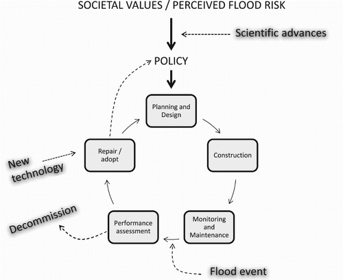
At the onset of the cycle is flood management policy, which develops in response to national priorities (e.g. environmental, agricultural, urban development, cultural resources), the influence of societal values and the perception of flood risk to different stakeholders (DEFRA Citation2005, NRC Citation1999, Sayers et al. Citation2015). Aside from small dikes created by local government entities or subsistence communities, the planning and design of large main-stem dike systems is primarily carried out by federal government institutions (Havekes et al. Citation2010). Federal guidelines require that dike construction includes detailed geophysical information, especially in relation to the local sedimentary, geomorphic, and topographic conditions of the environment in which the dike structure is embedded (Auerbach et al. Citation2015), with some of the work being subcontracted to ‘local’ operators. Similarly, the physical integrity of the dike is monitored and maintained according to specific federal guidelines. The performance assessment requires a team of local ‘flood fighters’ and personnel for monitoring dikes for breaching, underseepage, and sand boil formation (e.g. TAW Citation1995). Post-flood operations are organized around the identification of damaged dike sections with a time-line to complete repairs before the next flood season (DeHaan et al. Citation2012). Finally, an exchange of information across different organizations stimulates changes in the policy of flood management.
3. Study context
Prior to comparing flood management between the Rhine and Mississippi it is useful to briefly outline fundamental differences in physical and human characteristics of the two settings (). These differences developed over millennia to different physical and human controls, and influence the modern setting from the standpoint of the range of engineering options and motivations for various styles of flood management.
Table 1. Comparative physical and human indices of lower Mississippi and lower Rhine Rivers.
3.1. Physical and human setting
Indices related to population, port size, and the proportion of natural land cover, for example, are indicative of the Rhine being much more intensively impacted by human activities than the Mississippi River delta. Although the Rhine delta is much smaller than the Mississippi, it supports a population of about five million greater than the Mississippi delta (). The Mississippi delta, therefore, retains a much higher proportion of natural land cover than the Rhine delta. Indeed, ‘natural’ land cover within the Rhine is actually ‘engineered nature’ (Nienhuis Citation2008). Much of the population density and economic activities of the Rhine delta are directly related to the enormous port, with Rotterdam (and Europort) ranked eleventh and fifth in global port rankings for a number of container ships and tonnage, respectively.
In contrast to the intensively engineered lower Rhine, the lower Mississippi continues to support a wide range of natural processes associated with a complex fluvial-deltaic system (Twilley et al. Citation2016). The Mississippi delta supports a vital regional fishery valued at nearly three billion US dollars (annually), which produces a third of all US seafood. And, in contrast to the Rhine, the Mississippi delta has an extensive interior fishery related to large interdistributary bays and freshwater swamp basins. This includes the Atchafalaya swamp basin, the largest freshwater basin in North America. Many rural Louisiana communities are intricately linked to the natural environment through fishing and hunting for commercial and recreational purposes (Gosselink Citation1984, Twilley et al. Citation2016). By comparison, the Rhine delta has a much smaller interior fishery because of the loss of estuarine and riparian environments by embankment and enclosure of the Zuiderzee with the Afsluitdijk (closed in 1932), and especially enclosure of the Zeeland estuaries for the Delta Works project following the devastating 1953 flood. While a few traditional fishing villages retained a diminished coastal passage, most Rhine fishing villages have been effectively cutoff from their long-established coastal heritage (Van de Ven Citation2007).
An important distinction as regards flood management is that, because of its intensely engineered deltaic landscape the Rhine delta does not have natural wetlands to serve as a buffer for storm surge events. Louisiana, by contrast, has ample coastal wetlands that help to buffer coastal populations from storm surge events, with the current status of the wetlands being related to the geomorphic framework of channel belts and flood basins driven by the delta cycle (Gosselink Citation1984, Day et al. Citation2007). The effectiveness of wetlands in buffering storm surge events is directly related to characteristics of the marsh vegetation, particularly the stem density and vegetation height, which is greater in healthy coastal marshlands (Hu et al. Citation2015). This is indeed a key reason why high rates of coastal erosion in Louisiana, which average 75 sq. km annually, is of a major concern to coastal urban communities. The increased vulnerability of delta populations to storm surge events caused by coastal erosion is a major driver of management strategies along the Mississippi River delta (Day et al. Citation2007, Twilley et al. Citation2016).
3.2. Models of flood management evolution
Flood disasters drive paradigm changes in flood management (Katsuhama and Grigg Citation2010, Mens et al. Citation2011). While improvements in engineering and scientific understanding of geophysical processes steadily increase the overall effectiveness of flood management in general, the manner in which flood management is actually implemented, however, varies nationally because of the different roles and capacities of flood management organizations. Flood disasters and policy changes represent abrupt changes (i.e. hinge points) in the evolution of national flood management infrastructure. These hinge points are often associated with national changes in vision and philosophy that are ultimately implemented across varying governmental scales (Serra-Llobet et al. Citation2013, Ward et al. Citation2013). Models of flood management evolution that pertain to the lower Rhine and lower Mississippi are ‘incremental’ and ‘pendulum’, respectively.
The lower Rhine is well represented by an ‘incremental’ model of flood management evolution. Systematic changes along the lower Rhine occurred over many centuries, becoming more efficient and centralized as government organizations became increasingly robust (e.g. Kaijser Citation2002, Hudson et al. Citation2008, Van Heezik Citation2008, Havakes et al. Citation2015). The ultimate example of Dutch ‘hard engineering’ for flood control occurred following the infamous 1953 flood in the Netherlands, Belgium, and the UK. The event resulted in numerous dike breaches, and in the Netherlands was responsible for 1831 deaths in (mainly) rural coastal flood basins (Van de Ven Citation2007). The Dutch response to the catastrophic event was the extensive ‘Delta Works’ project, a comprehensive flood management plan that included dike fortification, flood basin storage, and massive storm surge barriers (Deltawerken Citation2016). By the time the project was completed in 1997 with the construction of the great arms of the Maeslantkering to seal off the River Maas (Rhine distributary) from North Sea storm surge events, the Delta Works was already considered one of the most effective and sophisticated flood management models for large coastal draining rivers (de Bruin Citation2006, Van de Ven Citation2007).
In contrast to the lower Rhine, the lower Mississippi is well represented by a ‘pendulum’ model of flood management evolution. This has occurred over about the last 150 years as flood management organizations developed, and is associated with oscillations in flood management alternating between federal- and local-scale organizations. The Great Mississippi Flood of 1927 is the largest flood disaster in US history and its impact on society and science has been thoroughly studied (e.g. McPhee Citation1989, Berry Citation1997). From a policy and governmental perspective, the immediate outcome of the 1927 flood was a shift from local and state control to a substantially fortified federal role in flood management with US Congressional passage of the 1928 Mississippi River and Tributaries Project (1928 MR&TP) (US Congress Citation1928). This resulted in a change from a passive federal role characterized by a ‘no cutoff’ (i.e. ‘levees only’) approach to a strong federal role comprised of four major elements, including (i) repair and construction of 3200 km of dikes, (ii) river channel ‘improvements’, specifically cutoffs of meander bends (e.g. channelization), wing dikes (groynes) for channel alignment, bank stabilization, and dredging, (iii) dam and reservoir construction on upstream tributaries, and (iv) downstream flood crest reduction by routing floodwaters into backwater areas and through flood bypass structures (MRC Citation2007, Hudson et al. Citation2008).
While the 1928 MR&TP is not yet complete (scheduled for 2021 completion) it remains the designated flood management system for the main-stem lower Mississippi River. The 1928 MR&TP has been revised numerous times in federal Flood Control Acts of 1936, 1938, 1941, 1946, 1950, 1954, 1962, 1965, 1968, and 1986, which influenced the funding and construction of individual projects. The 1968 and 1986 Acts, for example, were associated with increased federal control (in 1968) and then deregulation (in 1986) and a loss of federal control, as funding authority was delegated to local and state-level entities in the 1980s. A major federal stimulus was the 1965 Lake Pontchartrain and Vicinity Hurricane Protection Project. In part, the failure of flood walls and dikes during the 2005 Katrina–Rita Hurricanes was attributed to the earlier transfer of dikes and their maintenance from the US Army Corps of Engineers (USACE) to local levee boards (Select Bipartisan Committee Citation2006, US GAO Citation2006, ASCE Citation2007, Rogers Citation2008, IPET Citation2009).
In the Netherlands, hydrologic and environmental problems with the ‘hard engineering’ approach to flood control came to a head in the early 1990s (Nienhuis Citation2008). Large flood events in 1993 and 1995 (recurrence intervals of 50 and 70 years) were barely contained by the dike system. The events exposed the vulnerability of the Delta Works system that had been internationally lauded as a great feat of engineering. The threat of the 1993 and 1995 flood events was placed in the context of global environmental change, and became the stimulus for a new major national plan in 1996 entitled ‘Room for the River’ (Middelkoop and Van Haselen Citation1999, Silva et al. Citation2001, Rijkswaterstaat Citation2009). The Room for the River plan is considered a model of ‘integrated flood management’. In addition to a variety of engineering options the plan includes non-structural strategies that integrate local stakeholders in decision-making processes to realize national management priorities (Van den Brink et al. Citation2014). Important physical changes in IFM include measures such as the movement of dikes away from the channel, lowering groynes, and the creation of side channels within the embanked floodplain to store flood waters to reduce downstream flood risk (). And a key secondary motivation is to restore the geodiversity and biodiversity of riparian wetlands.
Table 2. Major elements of IFM adapted to the Rhine deltaa.
4. Comparison of governance of flood management in the Netherlands and Louisiana
Room for the River is the benchmark standard of ‘integrated flood management’ for lowland rivers. It is important to note that the plan is specifically tailored to the Dutch Rhine, a subsiding delta that has been intensively engineered and degraded by human activities for many centuries. Nevertheless, the plan inherently includes an integrated drainage basin approach, especially as concerns international coordination with upstream government entities. International coordination became a formal requirement with a passage of the European Union’s Water Framework Directive (2000/60/EC), which in itself utilized much of the Dutch plan as a template for its sweeping legislation.
Major flood disasters inevitably result in the reexamination of policies and protocols. And as floods are locally manifest phenomena driven by national- and international-scale influences, it is reasonable to review the roles and linkages of different scales of governmental institutions as regards flood management. As the lower Rhine and Mississippi Rivers are prime examples of European and US lowland fluvial systems, respectively, a comparison of the governmental framework for flood management ( and ) elucidates important differences in flood management vision and organization.
Table 3. Management structure for the Dutch Rhine.
Table 4. Management structure for the lower Mississippi.
4.1. International-scale governance
Because the Dutch Rhine is the lowermost reaches of a large watershed that drains eight nations, international cooperation with upstream nations is essential. The transition to the Room for the Rhine approach to flood management also involved a considerable exchange with international organizations (Silva et al. Citation2001, Van den Brink et al. Citation2014). Indeed, even before the large floods of 1993 and 1995 the management of the Rhine basin was becoming increasingly internationally coordinated. Two major international organizations designated explicitly to coordinate management of the Rhine, although not exclusively for flooding, include the International Commission for the Protection of the Rhine (ICPR) and the Central Commission for Navigation on the Rhine (CCNR).
The ICPR formed in 1815 and is the oldest international organization involved in watershed management. The key role of the ICPR is to promote sustainable development of the Rhine basin, and this especially includes protection and restoration of its ecosystems, floodplains, water quality, and reduced flood risk. The ICPR provides specific targets thresholds for ecosystem health, floodplain and river channel conditions, and water quality, as well as protocols for monitoring and information exchange. In 2000 the ICPR seamlessly integrated the European Union’s Water Framework Directive (2000/60/EC) into its action plans and timetable (EC Citation2000). The ICPR has an especially strong international environmental mandate and its basin approach to management extends from its headwaters in the Swiss Alps to the North Sea coastal zone. While navigation is not the same as floodplain management, as part of its focus on maintenance of a navigable channel the CCNR promotes the environmental health of river channels within the Rhine basin, which can also be seen as supportive of an integrated approach to flood management. In particular, the CCNR has an effective organizational and legal framework in place to link relevant stakeholders for problem-solving.
As 99% of the Mississippi drainage is within the US it is not surprising that historically there have been minimal international perspectives integrated into US styles of flood management. In the wake of Hurricanes Katrina–Rita flooding of New Orleans and the US Gulf Coast, however, international perspectives have become more integrated into US flood management.
4.2. National-scale governance
From the perspective of a national framework both the US and the Netherlands have strong federal-scale institutions and policies regarding the design, construction, and operation of flood control infrastructure. The implementation of large engineering works along large rivers requires an appropriate scale of resources and operations. The design of dikes and floodgates, for example, requires model (scaled) simulations which in themselves require substantial expenditures, as well as massive engineering works literally constructed into the sovereign soil.
The USACE is by far the dominant federal presence as concerns flood management across the US, and especially the lower Mississippi because of its continued implementation of the 1928 MR&TP and the 1965 Lake Pontchatrain and Vicinity Project. The USACE is mandated to cooperate with other federal entities for issues related to its flood management infrastructure and the lands they influence (USACE Citation2000). This includes, for example, the US Fish and Wildlife (USFWS) in regard to the Endangered Species Act and the Clean Water Act (i.e. Section 7 and 404 of the ESA and CWA, respectively). An important role of the USACE is its authority to issue permits for modifying wetlands for projects authorized by the US Congress, which includes both removal and restoration of riparian wetland habitat. This can seem a somewhat curious responsibility considering the competition between agricultural and environmental stakeholders across lowland floodplains, and because the USACE is often the agency directly involved in the actual engineering (e.g. draining, diking, ditching, etc.) of floodplain wetlands for development and flood management. The US Environmental Protection Agency (US EPA) can ultimately rule against the USACE if it is deemed to not be in compliance with section 404c of the Clean Water Act regarding the physical and ecological health of the nation’s surface waters. The US FWS holds similar veto authority as regards the ESA, leverage especially vital to the sustenance of riparian ecosystems in the case of proposed floodplain drainage projects. Unfortunately, because the ultimate decision to invoke either the CWA or the ESA is by a politically appointed director, the interpretation of compliance of these fundamental federal policies waxes and wanes with White House residency.
The main federal organization in the Netherlands concerning flood management along the Rhine River is the Rijkswaterstaat, which is responsible for the design and construction of major flood control infrastructure. The Rijkswaterstaat implements the National Water Plan, which is formally approved by Parliament. The most recent Water Plan extends from 2016 to 2021 (Delta Commission Citation2016) and represents a tremendous evolution since the original 1953 Delta Plan. The latter was especially oriented towards hard engineering solutions while the former also includes ‘soft’ approaches to flood management. A fundamental characteristic of the national Water Plan and the Rijkswaterstaat is their effectiveness in coordinating across governmental scales, from international to local (Van den Brink et al. Citation2014). This includes European levels, such as the ICPR and the European Union. The Rijkswaterstaat implements the EU Water Framework Directive within the national Water Plan, and also ensures that such international plans are synchronized with local-scale institutions.
4.3. Regional scale governance
At the regional level of flood management are Dutch provinces and US states. From the perspective of shaping flood management policy and implementing management, provincial and state-level institutions are relatively weak. The main influence of state and provincial governments concerns the management of lands within flood control areas, such as the embanked floodplain, where they may establish parks, nature preserves, and regulate activities such as agriculture and resource extraction (e.g. timber, aggregate). But states and provinces are not usually involved in the direct design and construction of flood control infrastructure. The six states bordering the lower Mississippi, for example, have a little direct influence on the planning or maintenance of dikes or drainage. Smaller tributary rivers may include ‘watershed management’ districts coordinated by states, but this is largely for utilization of water resources and coordination with conservation strategies at the federal level, such as the Endangered Species Act and the Clean Water Act. By comparison with flood management in the Netherlands, however, US states have more influence over local scales of management along the lower Mississippi.
A recent development concerning state-level management of the Mississippi River delta is the Louisiana Coastal Protection and Restoration Authority (CPRA), formed as a direct outcome of the 2005 Hurricanes Katrina–Rita devastation of the Louisiana coastal zone (CPRA Citation2017). The primary reason for the establishment of the CPRA was to work towards coordination of restoration activities under a single overarching plan within the state of Louisiana. Additionally, the CPRA coordinates the plan across different stakeholders, including at the scales of levee boards and individual municipalities (CPRA, Citation2017). This role was a formal requirement mandated by the federal government for Louisiana to receive federal funding for coastal restoration, because federal agencies found it inefficient and complex to deal with multiple local stakeholders. While the CPRA is not directly focused towards river management, the inherent linkages between the upstream Mississippi basin and coastal erosion effectively require the CPRA to embrace an integrated approach to coastal management. A key example is the design of freshwater and sediment diversions from the main-stem Mississippi River into subsiding marsh basins, which is vital to buffer storm surge events (Peyronnin et al. Citation2013; Hu et al. Citation2015, Twilley et al. Citation2016).
4.4. Local-scale governance
An important distinction between the Netherlands and the US related to flood management of the Rhine and lower Mississippi concerns the relationship between regional scale institutions and local-scale institutions (, ). As opposed to regional-scale entities, local-scale levee boards and water boards have vital roles regarding flood management in the US and the Netherlands, respectively. US levee boards are coordinated within states and confined to state borders, regardless of whether the hydrologic entities (e.g. lakes, canals, ditches, ponds, rivers, and other hydrographic features) extend across state borders. Within states, the limits of most levee board districts are coincident with county (or parish) borders. Additionally, between different states there is a range of models for how levee boards are structured and coordinated for different river basins, and even along the same river.
Figure 2. (A) Lower Mississippi model (U.S. context). The structure and relationship between different governmental scales for flood management along the lower Mississippi in Louisiana. (B) Lower Rhine model (Dutch context). The structure and relationship between different governmental scales for flood management in the Netherlands.
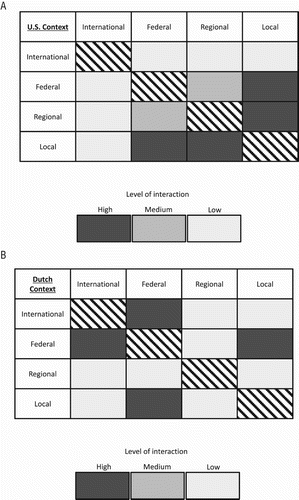
Table 5. Multi-criteria comparison of Louisiana levee boards and Dutch water boards.
Along the lower Mississippi River and delta, the rules governing levee boards varies by state. Members of levee boards may either be appointed by the executive branch (governor) or elected from within the levee board district. Levee boards within the states of Arkansas and Mississippi, for example, have elected board members representing each county within their districts. The members of the levee boards then determine their president (i.e. chair). In Louisiana, however, levee board members are not democratic. The members are appointed directly by the governor and confirmed by the state senate, after being nominated by the levee board (La state legislature, Article VI, §330.1, S 38.1). Levee boards within Louisiana determine their own president. The level of expertise for levee board members also varies considerably, and ranges from engineers, accountants, academics, lawyers, to journalist (ALBL, Citation2012). Levee boards usually hire professional engineers as staff, or for specific projects on an ad hoc basis. And levee boards also consult with state-level engineers (e.g. highway department), as well as the USACE. There is no requirement, however, that specific types of stakeholders, such as environmental and industry, are included in the composition of levee boards. Additionally, the formal rules of levee boards are determined by the state legislature. From the standpoint of financing, levee boards impose property taxes from residents and other land owner within their districts. Most of the annual operating revenue derives from the lease of lands within their district. This includes a diverse range of commercial interests, such as the sale of timber, pasture for agriculture, access to ports as well as revenue from fossil fuel companies that utilize lands for drilling and related activities. This helps to keep residential taxes low, which are based on property values. The Yazoo Mississippi Delta Levee Board, for example, maintained the same tax rate for 18 years, between 1996 and 2014. The closure of a river boat casino, however, resulted in an immediate loss of revenue and a compensatory increase in residential property taxes.
Upon completion of federal dikes, the responsibility for operation, maintenance, and repair of the dike is transferred to levee boards, with the USACE retaining a permanent right of access. At the moment of transfer, US levee boards are then held to standards established by the USACE (33 CFR Section 203.86). One issue concerns actual completion of dike and other flood control infrastructure projects. Prolonged delays, up to several years, in the completion of infrastructure projects can occur. Delays are primarily attributed to a lack of appropriated funding, as well as environmental, cultural heritage, seasonal weather conditions, or in obtaining appropriate construction materials. The significance of such delays is that it results in a lack of clarity as to when infrastructure projects are actually completed, and which organization is liable. This is important because it means that essential maintenance and monitoring may not occur, potentially resulting in dysfunctional infrastructure and an increase in flood risk during high flow periods (ILIT Citation2006, US GAO Citation2006, IPET Citation2009).
By comparison with Louisiana levee boards, Dutch water boards differ in several fundamental respects (). First, the spatial limits of water boards are actual hydrologic divides, either anthropogenic (polders) or natural. Water boards extend across provincial (political) borders, and have for centuries. This highlights an important second distinction of Dutch water boards, that provinces have no direct authority over water boards (Mostert Citation2016). The autonomy of Dutch water boards is written into national law (the Regional Water Act). Thirdly, Dutch water boards have consistency in their specific tasks and responsibilities, as well as their system of governance and source of revenues. This is specified directly in the national Regional Water Act and uniformly effects all 23 Dutch water boards. A fourth difference with US levee boards is the representative style of governance of Dutch water boards. Indeed, the democratic representation of water boards is a signature characteristic of Dutch water management, a practice that extends back to the late medieval period (1200s), far exceeding formation of the Netherlands as a nation (Van Dam Citation2002, Havakes et al. Citation2015). In terms of representation, in addition to residential interests, Dutch water boards are legally required to include local stakeholders from business, environmental, and agricultural interests within their board of directors. Because most of the revenue for Dutch water boards come from local residential property taxes, the largest share of seats on the governing board is reserved for resident (between 18 and 30 seats, depending on population). Stakeholder interests are represented with between seven and nine seats on the governing board, depending upon their concentration within the district. Water boards located in rural settings, for example, would have fewer business stakeholders whereas in the dense industrial western Netherlands business interests are strongly represented. Water boards do not design, construct, or own dikes, they maintain them according to standards defined by the Rijkswaterstaat (Havakes et al. Citation2015). Dutch water boards are mandated to implement national-scale policies and standards, but have autonomy as to how these are implemented.
5. Diffusion of ideas: the international legacy of the 2005 New Orleans flood disaster
The 2005 New Orleans flooding by Hurricanes Katrina–Rita have taken on epic proportions and stimulated important changes to the vision and practice of flood management. In particular this relates to the management of urban flood risk in large delta cities in relation to climate change (Vörösmarty et al. Citation2009), a topic that sees the 2005 New Orleans flood event as an often-cited case study (e.g. Cardona et al. Citation2012). For many nations and flood management organizations the 2005 flooding of New Orleans served as the proverbial wake-up call (Dijkman Citation2007). The disaster prodded government institutions and scientists to ask difficult questions about the preparedness of national flood control infrastructure, dike systems in particular. Along the Rhine delta the Dutch conducted inventories and repairs of riverine and coastal dikes, some of which had indeed been initiated following successive large floods in 1993 and 1995, including new geophysical mapping, numerous borings, and associated laboratory analyses. This was complemented by contemplation about the broader role of flood management in society, and especially human and economic vulnerability to flooding (Wesselink Citation2007, Mens et al. Citation2011). And of course, the silver lining in the 2005 New Orleans flood disaster is that it stimulated a robust exchange of ideas between the US and the Netherlands (e.g. US Congress Citation2005). A basic template for information exchanges had already started to take shape before the flood in a 2004 Memorandum of Agreement (MoA Citation2004) between the Rijkswaterstaat and the US Army Corps of Engineers. The intent of the 2004 MoA was to establish a long-term relationship to foster the exchange of ideas related to a broad range of topics, which in addition to flood management, included navigation, dredging, and coastal development. While the intention was to establish a two-way exchange between the Netherlands and the US, after the 2005 flood disaster the agreement initially became more of a one-way exchange from the Netherlands to south Louisiana with the main focus obviously being flood management (Dijkman Citation2007; USACE Citation2009a). Since 2008, however, staff from the USACE and Rijkswaterstaat have met biannually in the US and The Netherlands to exchange ideas and technical information related to dike safety.
5.1. The 2007 IPCC report and the 2007 EU floods directive
A fortunate dimension to the timing of the disastrous 2005 New Orleans flood was that it occurred with heightened scientific and societal awareness of climate change and sea level rise, and also with impressive advances in the technological capacity to monitor and measure dike systems. Indeed, the influence of the New Orleans flooding was well cited within the IPCC’s monumental 2007 report on coastal lowlands and climate change (i.e. Nicholls et al. Citation2007). And five months after New Orleans flooded, the European Union enacted new legislation. The EU formally proposed sweeping legislation regarding flood protection months after New Orleans flooded, in early 2006 (Mens et al. Citation2011, Serra-Llobet Citation2014). The legislation was finalized and put into force as the EU Floods Directive in 2007 (60/EC). The Floods Directive required all EU member states to assess and map flood risk for all of its inland and coastal waterways, and to actively take measures to reduce flood risk (i.e. construct, repair and replace dikes, etc.). The Directive was designed to be seamlessly integrated within the Water Framework Directive (2000/60/EC), and the two are usually seen as a single body of legislation. A key facet of the Floods Directive is its implications regarding the development of an integrated governmental framework for managing flooding, as the Directive requires that local stakeholders have an active role in planning (Santato et al. Citation2013). Thus, a core element of Dutch flood management was implemented into an international agreement.
5.2. The US National Levee Safety Committee, Act of 2007 and 2009 report
In addition to stimulating a safety review of dike systems internationally (e.g. Morris et al. Citation2007), the catastrophic failure of the New Orleans flood walls resulted in an incredible level of scrutiny regarding the geophysical conditions of US flood management systems (ASCE Citation2007, NRC Citation2013). A major initiative was launched in the US with the Water Resources Development Act (also referred to as the National Levee Safety Act, NLSA Citation2007), which approved the formation of a National Levee Safety Committee (NLSC). The NLSC is to provide expert advice and recommendations to Congress regarding the status of the nation’s levee system, which includes developing strategic plans for how to implement a National Levee Safety Programme to increase the safety of the nation’s flood control levees. Subsequently, in 2009 the NLSC drafted a Report with recommendations to Congress. The 2009 NCLS Report is a major document that seeks to reshape the policy of flood management for a large nation, and thus has ramifications as it is implemented through differing scales of government agencies overseeing flood management and levee design (NCLS Citation2009).
The 2009 NCLS Report recommendations include (i) establishing a national committee to oversee levee safety, (ii) required inspections with standardized criteria, and (iii) increase levee flood safety from the 100-yr to a 200-yr safety level, (iv) design levees around the concept of flood risk rather than static hydrologic levels, and (v) providing funding for levee works (flood control) to the federal government. The flood risk concept, whereby human safety and economic activity are formally considered, has been an evolving practice within the USACE (NRC Citation2013). Indeed, in 1977, 25 years prior to the 2009 NCLS Report, the USACE issued guidelines for the implementation of Executive Order 11988: Floodplain Management (USACE, Citation1984). Considering the era in which it was enacted, (EC Citation1977) EO 11988 represents progressive policy, as it explicitly directed federal agencies to avoid floodplain development (when possible) in recognition of its adverse impacts to both flood risk and the environment.
The 2009 NLSC Report’s recommendations regarding funding are significant from the context of the historical evolution of US flood management, as it represents yet another pendulum shift; from local-scale interests to federal-scale interests. In essence, the 2009 NLSC Report strongly advocates for stronger federal control over flood control (levee) projects. Considering that the Chair of the Committee is from the USACE, it is not surprising that the recommendations aligned with a much more robust role of the federal government in flood management, the USACE in particular.
The lack of fundamental information about the US dike system stimulated Congress to require the development of a master database about the status and characteristics of US flood control dikes. The task of creating and maintaining the database was, logically, put under the direction of the USACE. The database (http://nld.usace.army.mil/) is intended to represent a central point to obtain information regarding the monitoring, maintenance, and status of federally (i.e. USACE) constructed dikes. Additionally, the database is intended to facilitate information exchange with the National Flood Insurance Program and other relevant stakeholders, especially for safety and risk assessment. A disturbing realization is, by its own admission, that the US federal government does not know very much about its system of flood control dikes. While this is probably the case across many nations (e.g. DELWP Citation2015), the American Society of Civil Engineers (ASCE Citation2007) contends that American dikes are in dire condition, with numerous sections close to failure. In the US there are over 160,000 km of dikes, although it is clear that there is no way to obtain a precise number. Of these dikes, only 4500 km were constructed and are being managed by the USACE. An additional 3500 km of dikes were constructed by local interests and are managed and maintained by the USACE. An additional 15,000 km of dikes were constructed by the USACE but are being locally managed and maintained. Thus, the vast majority of America’s dikes, some ∼77,000 km, have had no federal oversight, either in construction or management. Half of America’s dikes were built and are being managed by local (or state) interests, rather than a consistent national standard (NCLS Citation2009).
While the increased attention to dike safety represents a positive outcome of the 2005 Hurricanes Katrina–Rita flood of south Louisiana, there continues to be a divide between the issues of flood safety and the environment in the US that is not as strongly present in Europe. Unlike the modern Dutch approach to flood management (e.g. Van den Brink et al. Citation2014, Delta Commission Citation2016), the 2009 NCLS Report provides little attention to climate change or environmental issues related to flood management and levee design. And even ground subsidence is only mentioned two times. The thrust of the report’s attention to environmental issues is related to the avoidance of costly delays in complying with regulations, rather than enhancing floodplain ecosystems and riparian environments. As a whole, the report only minimally recognizes the potential adverse impacts that dikes cause to floodplain environments, and, in contrast to the European and Dutch approach, there is a lack of appreciation for the role of floodplain environments in reducing flood risk (e.g. LMRCC Citation2015).
There is a division of consensus at the US federal level between engineering-oriented federal agencies (i.e. the USACE) and national scientific (scholarly) bodies (i.e. NRC) as regards managing flood safety and floodplain ecosystems. In contrast to the 2009 NLSC Report, the National Research Council advocates the integration of modern environmental scientific perspectives with flood control engineering (i.e. NRC Citation1999, Citation2013). And in contrast to the US perspective, the 2008 and 2016 Netherlands Delta Report issued by the Delta Commission to Dutch parliament regarding its recommendations for flood management strongly embraced an environmental perspective. In comparison, it is striking how much of the 2008 and 2016 Dutch Delta Report concerns climate and environmental change. That is, there is a clear recognition that engineering solutions can be determined for flood safety at a very high standard (500–10,000-yr flood events) whilst nature and ecosystem processes are conserved, enhanced, and even restored. The Delta Report makes a compelling case for why the Netherlands dike system needs to be fortified in relation to specific climatic and sea level projections (storm surge, drought, flooding, etc.).
5.3. European and US exchange: The International Levee Handbook of 2013
A major international initiative launched in the wake of 2005 New Orleans flooding, following further severe flooding in continental Europe, occurred in 2008. In this instance, an international coalition of federal stakeholders formed to establish a framework for relaying important practices and protocols in the design and management of dikes for climate resilient flood management. Five years later a massive + 1300 page volume, The International Levee Handbook, was published (CIRIA Citation2013). The International Levee Handbook is an effort from federal flood management organization in the US, France, UK, the Netherlands, and Germany. The contributors are the respective national institutions charged with flood management, including, for example, the USACE and the Rijkswaterstaat. Drawing upon up-to-date scientific approaches and thoroughly documented experiences with flooding, the International Levee Handbook provides a comprehensive and detailed overview of ‘best practices’ in the design of dike systems for flood management. The volume provides guidelines for the design, construction, maintenance, and monitoring of dike systems. It is written from an engineering perspective, and is accessible to readers with a moderate level of technical training. A limitation of the effort, however, is that while it explicitly mentions the need to design ‘environmentally friendly’ dike systems it does not provide explicit guidance for the restoration of riparian ecosystems. This can be seen as a shortcoming of the volume in view of the extensive science that exists within this applied field of ecosystem management (e.g. Nienhuis Citation2008). Nevertheless, that the International Levee Handbook explicitly includes engineering in relation to IPCC projected changes in discharge variability caused by climate change as well as sea-level rise, should be viewed as especially important to the US.
5.4. Towards a US model of IFM
While US governmental institutions were reluctant to formally integrate global environmental change scenarios into flood control engineering, that the USACE was an active collaborator on the International Levee Handbook is symbolically important. And amongst US scientists and other national level organizations there is clear acknowledgement of the need to consider climate change and sea level rise in relation to flood management (ASFPM Citation2008). This was facilitated by US expertise being actively engaged in an international exchange of ideas regarding IFM practices. And increasingly major bodies of US scholars, such as the National Academies of Sciences, advocated for a more ‘integrative’ approach to flood management than provided by traditional hard engineering approaches long practiced by the USACE (e.g. NRC Citation1999, Citation2013). A long withstanding obstacle to the design of IFM infrastructure was reluctance at the national level to formally consider climate change into federal engineering designs. But the coastal storm surge flooding caused by Hurricanes Katrina–Rita abruptly changed the discussion, at least in terms of sea-level rise. In 2009 the US Congress formally mandated that the design of coastal flood control infrastructure consider sea-level rise projections published by the IPCC (US EPA Citation2009, USACE Citation2009b, Citation2014).
The influence of an international consensus on climate change and the importance of engineering ‘climate resilient’ flood management infrastructure have gained much support in the US (ASFPM Citation2015, ALBL Citation2016, US EPA Citation2016). Curiously, while this view was becoming more firmly established across scientific organizations, the USACE advocated against the development of a European or Dutch style ‘room for the river’ approach to flood management along the lower Mississippi (Camillo Citation2012). White House Executive Order 13690 (issued in 2015) championed federal flood risk management standards that included many tenants of IFM found in European approaches. Supported by considerable scientific research, EO 13690 sought to provide further definition and clarity to EO 11988 (issued in 1977). Specifically, the intention of EO 13690 was to require climate change projections be included in the design of flood management infrastructure and that a modern ‘flood risk’ approach (i.e. NRC Citation2013) be utilized in the design of flood management infrastructure. This represented a fundamental shift away from the 1968 National Flood Insurance Policy (NFIP) approach, which mandated a rigid 100-yr recurrence interval. Specifically, EO 13690 provided three options for designing federal flood control dikes, including (i) utilizing best ‘actionable’ climate change science, (ii) construct dikes 0.66 m higher than the standard 100-yr recurrence interval flood elevation, or (iii) design dikes to a 500-yr flood recurrence interval elevation. Implementation of EO 13690 would have required stakeholders, such as levee boards, to develop a plan based on one of the three above approaches in coordination with federal agencies, such as the Federal Emergency Management Agency, Federal Interagency Floodplain Management Task Force, and the Water Resources Council (ASFPM Citation2015, FEMA Citation2015). Thus, agencies were to have several options to enable them to alter the placement of dike systems in accord with regional and local priorities, such as nature preservation, cultural heritage, and urbanization (FEMA Citation2015). A move towards this more ‘integrative’ approach to flood management would have solidified the paradigm change in the vision and mechanics of US flood management, with considerable implications to the lower Mississippi and, in particular, New Orleans.
EO 13690 was challenged by some stakeholders, and the Louisiana levee boards were especially opposed to its implementation, maintaining that the new standards would adversely impact the Louisiana economy. Resistance to EO 13690 also occurred because it was formulated on the basis of climate change science, to which there is a formal opposition by the Louisiana levee boards (Association of Louisiana Levee Boards 2015). Considering the structure of governance of Louisiana levee boards, however, they would have had much latitude in the implementation of EO 13690. Beyond Louisiana, the new standards of EO 13690 were welcomed by a large swath of national stakeholders, including the Association of State Floodplain Managers (Citation2015).
In accord with the ‘pendulum’ model of flood management in the US, the new White House administration rescinded EO 13690 with its own Executive Order on 15 August 2017. EO 13690 was rescinded about two weeks prior to the devastating flooding by Hurricane Harvey of the Houston metropolitan and coastal southeast Texas and southwest Louisiana. Government agencies have not formally communicated flood recurrence intervals from the inundation caused by the extreme rainfall totals generated by Hurricane Harvey. The degree that the Hurricane Harvey flood event will represent a new ‘hinge point’ (e.g. Katsuhama and Grigg Citation2010, Mens et al. Citation2011) in the cycle of US flood management will therefore require additional time to realize.
6. Conclusions and the way forward
Flood management in the US and the Netherlands is characterized by strong federal governmental institutions and rather weak regional-scale governmental organizations. A major distinction between flood management in the US and the Netherlands is the role of local-scale institutions, and this is especially present along the lower Mississippi. Louisiana levee boards are top-down institutions, as members are appointed at the state level (and thus are not independent of state-level politics). Dutch water boards, by contrast, are bottom-up democratic institutions and members are accountable to their constituencies. A key feature of Dutch water boards is that they are federally mandated to include specific numbers of stakeholders, including environmental, municipal, agricultural, and industry. This ensures that each water board has demographic representation that is thematically proportional. And, there is a clear procedure for how stakeholder interests are forwarded to federal levels (e.g. Rijkswaterstaat) so that they have input on larger planning and management initiatives. In contrast, Louisiana levee boards do not require that stakeholder interests be represented, or a specific governmental mechanism by which their voice is brought to the federal level. A recent positive development (i.e. post 2005 New Orleans flood) on this front concerns levee boards in south Louisiana that protect greater metropolitan New Orleans. Following their reorganization after the 2005 Hurricanes Katrina–Rita flood, the Louisiana CPRA helps to coordinate between federal and local-scales, and levee boards are required to include scientific expertise from associated universities. The lack of consistency in membership within the state of Louisiana and between different states along the lower Mississippi, however, represents an inherent weakness in the organizational framework of flood management and the management of dike systems.
Flood management evolves in response to extreme flood disasters. The Dutch Room for the River approach to flood management represents a mature entity, the penultimate outcome of an incrementally adaptive system that has evolved over hundreds of years, including the hard engineering approach of the Delta Works program. Flood management along the lower Mississippi, in contrast, continues to make major pendulum style adjustments, with recent developments favouring stronger federal control. The devastating 2005 New Orleans and coastal flood disaster by Hurricanes Katrina–Rita triggered a paradigm change in flood management within the US with international linkages that recognize global climate change. Thus, international exchanges and agreements between federal agencies involved in flood management have increased, and should be seen as favourable and essential to the development of a climate resilient ‘cycle of dike management’ (e.g. ). The 2007 EU Floods Directive, as an example, required that the safety status of flood control infrastructure be inventoried and repaired to specific standards by 2015. Along the coastal Mississippi delta, plans to restore wetlands by sediment diversions are being guided by contemporary climate change science through the Louisiana CPRA. An additional example that represents an international exchange of ideas from the EU and US is the recently completed International Levee Handbook. The effort is a major compilation and extensive synthesis of best practices in the design, construction, and management of dikes. This is especially important in an era of climate change and sea level rise, and because aging flood management infrastructure requires an increasing amount of maintenance. Such international exchanges should be seen as a stimulus for the US to move towards a new vision for flood management that includes some of the major tenants of IFM practiced in Europe, of urgent necessity in an era of global environmental change.
Acknowledgements
Anonymous reviewers provided comments, criticisms, and suggestions that led to an improved manuscript. Students and colleagues provided useful feedback. Discussions with Hans Middelkoop (Utrecht University) some 10 years ago led to the idea of doing a comparative study of flood management and governance between the US and the Netherlands.
Disclosure statement
No potential conflict of interest was reported by the author.
ORCID
Paul F. Hudson http://orcid.org/0000-0003-2534-2720
References
- American Society of Civil Engineers (ASCE), 2007. The New Orleans Hurricane protection system: what went wrong and why. Reston, VA: American Society of Civil Engineers Hurricane Katrina External Review Panel, 92 p.
- Asselman, N.E.M., 1999. Suspended sediment dynamics in a large drainage basin: the River Rhine. Hydrological Processes, 13, 1437–1450. doi: 10.1002/(SICI)1099-1085(199907)13:10<1437::AID-HYP821>3.0.CO;2-J
- Association of Levee Boards of Louisiana (ALBL), 2012. Handbook of Louisiana levee boards. Available from: http://albl.org/wp-content/themes/alblredux/resources/documents/2012ALBLBOOK.pdf [Accessed 10 April 2017].
- Association of Levee Boards of Louisiana (ALBL), 2016. Position on flood control issues. December 2015. Available from: http://albl.org/documents/ [Accessed 25 June 2017]
- Association of State Floodplain Managers (ASFPM), 2008. Floodplain Management 2050: A Report of the 2007 Assembly of the Gilbert F. Washington, DC: White National Flood Policy Forum.
- Association of State Floodplain Managers (ASFPM), 2015. Executive order 13690 and the new federal flood risk management standard explained. ASFPM News & Views, 28 (1).
- Auerbach, L.W., et al., 2015. Flood risk of natural and embanked landscapes on the Ganges–Brahmaputra tidal delta plain. Nature Climate Change, 5, 153–157. doi: 10.1038/nclimate2472
- Benito, G. and Hudson, P.F., 2010. Flood hazards: The context of fluvial geomorphology. In: I. Alcantara-Ayala and A. Goudie, eds. Geomorphological hazards and disaster prevention. Cambridge: Cambridge University Press, 111–128.
- Berry, J.M. 1997. Rising tide: The great Mississippi flood of 1927 and how it changed America. New York: Simon & Schuster.
- Butzer, K.W, 1976. Early hydraulic civilisation in Egypt: a study in cultural ecology. Chicago: University of Chicago Press, 150 p.
- Camillo, C.A., 2012. Divine providence: The 2011 flood in the Mississippi River and tributaries project. Vicksburg: Mississippi River Commission, 312 p.
- Cardona, O.D., et al., 2012. Determinants of risk: exposure and vulnerability, Ch. 2. In: C.B. Field, et al., eds. Managing the risks of extreme events and disasters to advance climate change adaptation. A special report of working groups I and II of the intergovernmental panel on climate change. Cambridge: Cambridge University Press, 65–108.
- CIRIA, 2013. The international levee handbook (C731). London: CIRIA, ISBN: 978-0-86017-734-0.
- Coastal Protection and Restoration Authority of Louisiana (CPRA), 2017. Louisiana’s comprehensive master plan for a sustainable coast. Baton Rouge, LA: Coastal Protection and Restoration Authority of Louisiana. Available from: http://coastal.la.gov/wp-content/uploads/2017/04/2017-Coastal-Master-Plan_Web-Book_CFinal-with-Effective-Date-06092017.pdf [Accessed 2 July 2017].
- Day Jr., J.W., et al., 2007. Restoration of the Mississippi delta: lessons from hurricanes Katrina and Rita. Science, 315 (5819), 1679–1684. doi: 10.1126/science.1137030
- De Bruin, D., 2006. Similarities and differences in the historical development of flood management in the alluvial stretches of the lower Mississippi basin and the Rhine Basin. Irrigation and Drainage, 55, S23–S54. doi: 10.1002/ird.240
- DEFRA, 2005. Making space for water: taking forward a new government strategy for flood and coastal erosion risk management forward in England. London: DEFRA.
- DeHaan, H., Stamper, J., and Walters, B., 2012. Mississippi River and tributaries system 2011 post-flood report. Vicksburg: U.S. Army Corps of Engineers, Mississippi Valley Division, 306 p, 4 plates.
- Delta Commission, 2016. National water plan 2016-2021. The Hague: Ministry of Infrastructure and the Environment, Rijkswaterstaat.
- Deltawerken.com [Accessed 25 May 2016].
- Department of Environment, Land, Water and Planning (DELWP), 2015. Levee management guidelines. Melbourne: The State of Victoria.
- Dijkman, J., 2007. Dutch perspective on coastal Louisiana flood risk reduction and landscape stabilization, first interim report. London: U.S. Army Corps of Engineers, European Research Office of the U.S. Army.
- European Council (EC), 2000. Directive 2000/60/EC of the European Parliament and of the Council of 23 October 2000. Establishing a framework for community action in the field of water policy.
- European Council (EC), 2007. Directive 2007/60/EC of the European Parliament and of the Council of 23 October 2007 on the assessment and management of flood risks.
- Executive Order 11988. 1977. Floodplain management, May 24.
- Executive Order 13690. 2015. Establishing a federal flood risk management standard and a process for further soliciting and considering stakeholder input, January 30.
- Federal Emergency Management Agency (FEMA), 2015. Revised guidelines for implementing executive order 11988, floodplain management. Available from: https://www.fema.gov/media-library/assets/documents/101761 [Accessed 29 October 2016]
- Gosselink, J.G., 1984. The ecology of Delta marshes of coastal Louisiana: a community profile. Washington, DC: U.S. Fish Wildlife Service, FWS/OBS-84/09, 134 pp.
- Havekes, H., et al., 2010. Water governance: The Dutch regional water authority model. The Hague: Unie van Waterschappen.
- Havakes, H., et al., 2015. Water governance: The Dutch water authority model. The Hague: Dutch Water Authorities.
- Hu, K., Chen, Q., and Wang, H., 2015. A numerical study of vegetation impact on reducing storm surge by wetlands in a semi-enclosed estuary. Coastal Engineering, 95, 66–79. doi: 10.1016/j.coastaleng.2014.09.008
- Hudson, P.F., Middelkoop, H., and Stouthamer, E., 2008. Flood management along the lower Mississippi and Rhine Rivers (The Netherlands) and the continuum of geomorphic adjustment. Geomorphology, 101, 209–236. doi: 10.1016/j.geomorph.2008.07.001
- Independent Levee Investigation Team (ILIT), 2006. Investigation of the New Orleans flood protection systems in Hurricane Katrina on August 29, 2005. Final Report. Available from: www.ce.berkeley.edu/~new_orleans/ [Accessed 29 September 2017]
- Interagency Performance Evaluation Task Force (IPET), 2009. Performance evaluation of the New Orleans and Southeast Louisiana Hurricane protection system. U.S. Army Corps of Engineers, Final Report. Available from: http://permanent.access.gpo.gov/lps71007/ [Accessed 18 June 2017]
- Jonkman, S.N., et al., 2009. Risk-based design of flood defence systems: a preliminary analysis of the optimal protection level for the New Orleans metropolitan area. Journal of Flood Risk Management. doi:10.1111/j.1753-318X.2009.01036.
- Kaijser, A., 2002. System building from below. Institutional change in Dutch water control systems. Technology and Culture, 43, 521–548. doi: 10.1353/tech.2002.0120
- Katsuhama, Y. and Grigg, N.S. 2010. Capacity building for flood management systems: a conceptual model and case studies. Water International, 35, 763–778. doi: org/10.1080/02508060.2010.533348
- Kolen, B., Hammes, S., and Juijskes, E., 2012. Flood preparedness in the Netherlands: a U.S. perspective. The Netherlands: U.S. Water Crisis Research Network.
- Lower Mississippi River Conservation Committee (LMRCC), 2015. Restoring America’s greatest river: a habitat restoration plan for the lower Mississippi River. Published electronically. Available from: http://lmrcc.org.Vicksburg, Mississippi [Accessed 23 June 2016]
- McPhee, J., 1989. The control of nature. New York: Farrar, Straus and Giroux.
- Meade, R.H. and Moody, J.H., 2010. Causes for the decline of suspended-sediment discharge in the Mississippi River system, 1940–2007. Hydrological Processes, 24, 34–49.
- Memorandum of Agreement (MoA) between the Ministry of Transport, Public Works and Water Management of the Netherlands, Directorate General Rijkswaterstaat and the United States Army Corps of Engineers, 2004.
- Mens, M.J.P., et al., 2011. The meaning of system robustness for flood risk management. Environmental Science & Policy, 14, 1121–1131. doi: 10.1016/j.envsci.2011.08.003
- Middelkoop, H. and Van Haselen, C.O.G.E., 1999. Twice a river. Rhine and Meuse in the Netherlands. Lelystad: Rijkswaterstaat RIZA.
- Middelkoop, H., Erkens, G., and Van der Perk, M., 2010. The Rhine delta – a record of sediment trapping over time scales from millennia to decades. Journal of Soil and Sediments, 10, 628–639. doi: 10.1007/s11368-010-0237-z
- Mississippi River Commission (MRC), 2007. The Mississippi River and tributaries project: controlling the project flood. Vicksburg: Mississippi River Commission.
- Morris, M., Dyer, M., and Smith, P., 2007. Management of flood embankments: a good practice review. Department for Environment, Food & Rural Affairs, Environment Agency, Research and Development Technical Report FD2411/TR1.
- Mostert, E., 2016. Between arguments, interests and expertise: the institutional development of the Dutch water boards, 1953-present. Water History. doi: 10.1007/s12685-016-0154-1
- National Committee on Levee Safety (NCLS), 2009. Recommendations for a National Levee Safety Program: a report to congress from the National Committee on Levee Safety.
- National Levee Safety Act (NLSA), 2007. 121 Stat. 1288, Public Law 110-114-Nov. 8, 2007, 110th Congress.
- National Research Council (NRC), 1999. New directions in water resources planning for the U.S. Washington, DC: U.S. Army Corps of Engineers, Committee to Assess the U.S. Army Corps of Engineers Water Resources Project Planning Procedures, Water Science and Technology Board, Commission on Geosciences, Environment, and Resources, The National Academies Press.
- National Research Council (NRC), 2013. Levees and the national flood insurance program: improving policies and practices. Washington, DC: Water Science and Technology Board, Division on Earth and Life Studies, National Academies Press.
- Nicholls, R.J., et al., 2007. Coastal systems and low-lying areas. In: M.L. Parry, O.F. Canziani, and J.P. Palutikof, eds. Climate change 2007: impacts, adaptation and vulnerability. contribution of working group II to the fourth assessment report of the intergovernmental panel on climate change. Cambridge: Cambridge University Press, 315–356.
- Nienhuis, P.H., 2008. Environmental history of the Rhine-Meuse Delta: an ecological story on evolving human-environmental relations coping with climate change and sea-level rise. Dordrecht: Springer, 640 p.
- Pescaroli, G. and Nones, M., 2016. Cascading events, technology and the floods directive: future challenges. Flood risk 2016, 3rd European conference on flood risk management. doi: 10.1051/e3sconf/20160707003
- Peyronnin, N., et al., 2013. Louisiana’s 2012 coastal master plan: overview of a science-based and publicly informed decision-making process. Journal of Coastal Research, 67, 1–15. doi: 10.2112/SI_67_1.1
- Pinter, N., et al., 2006. Flood magnification on the River Rhine. Hydrological Processes, 20, 147–164. doi: 10.1002/hyp.5908
- Rijkswaterstaat, 2009. Water management in the Netherlands. The Hague: Ministry of Infrastructure and the Environment.
- Rogers, J.D., 2008. Development of the New Orleans flood protection system prior to hurricane Katrina. Journal of Geotechnical and Geoenvironmental Engineering, 134, 602–617. doi:10.1061/ASCE1090-02412008134:5602
- Santato, S., Bender, S., and Schaller, M., 2013. The European floods directive and opportunities offered by land use planning. Climate Service Center, CSC Report 12. Available from: http://www.climate-service-center.de/imperia/md/content/csc/csc-report_12.pdf [Accessed 28 June 2017]
- Sayers, P., et al., 2015. Strategic flood management: Ten ‘golden rules’ to guide a sound approach. International Journal of River Basin Management, 13 (2), 137–151, doi: 10.1080/15715124.2014.902378
- Select Bipartisan Committee, 2006. A failure of initiative: Final report of the Select Bipartisan Committee to investigate the preparation for and response to hurricane Katrina, 109th Congress, 2nd Session, 109-377, 578 p.
- Serra-Llobet, A., 2014. Flood risk and global change: future prospects. American Geophysical Union, fall meeting 2014, abstract #GC41C-0589.
- Serra-Llobet, A., Tàbara, J.D., and Sauri, D., 2013. The Tous dam disaster of 1982 and the origins of integrated flood risk management in Spain. Natural Hazards, 65, 1981–1998. doi: 10.1007/s11069-012-0458-0
- Silva, W., Klijn, F., and Dijkman, J.P., 2001. Room for the Rhine branches in the Netherlands: what the research has taught us. Deltares, RIZA. uuid:12b2ad06-3469-49ea-a280-78e1dcc2fcb9
- Slomp, R., 2012. Flood risk and water management in the Netherlands: a 2012 update. The Hague: Rijkswaterstaat, Ministry for Infrastructure and Environment.
- TAW, 1995. Under pressure 1995: The condition of the Dutch river dikes during the flood period of January–February 1995. Delft: Technical Advisory Committee on Water Retaining Structures, 71 p.
- Törnqvist, T.E., 2007. A Dutch geoscience perspective on the Katrina disaster. Netherlands Journal of Geosciences – Geologie en Mijnbouw, 86, 307–315.
- Twilley, R.R., et al., 2016. Co-evolution of wetland landscapes, flooding, and human settlement in the Mississippi River Delta plain. Sustainability Science, 11, 711–731. doi: 10.1007/s11625-016-0374-4
- U.S. Congress, 1928. Flood Control Act, Mississippi River and Tributaries, Appendix E, 70th Congress, Session I, Ch. 596.
- U.S. Congress, 2005. Safety in the Netherlands. Statement to the United States Congress by Jan R. Hoogland, Director of Rijkswaterstaat.
- U.S. Army Corps of Engineers (USACE), 1984. Implementation of Executive Order 11988 on flood plain management. U.S. Army Corps of Engineers, Water Resources Policies and Authorities, ER 1165-2-26.
- U.S. Army Corps of Engineers (USACE), 2000. Design and construction of levees. U.S. Army Corps of Engineers, Engineering and Design, EM 1110-2-1913.
- U.S. Army Corps of Engineers (USACE), 2009a. Dutch perspective appendix. U.S. Army Corps of Engineers New Orleans District, Mississippi Valley Division, Louisiana Coastal Protection and Restoration Final Technical Report.
- U.S. Army Corps of Engineers (USACE), 2009b. Incorporating sea-level change considerations in Civil Works Programs Engineer Circular (EC), 1165-2-211.
- U.S. Army Corps of Engineers (USACE), 2014. Procedures to evaluate sea level change: impacts, responses and adaptation. Engineer Technical Letter 1100-2-1.
- U.S. Environmental Protection Agency (U.S. EPA), 2009. Climate change science program (CCSP): synthesis and assessment product 4.1: coastal sensitivity to sea-level rise: a focus on the mid-Atlantic region. A report by the U.S. Climate Change Program and the Subcommittee on Global Change Research. Washington, DC: U.S. Environmental Protection Agency.
- U.S. Environmental Protection Agency (U.S. EPA), 2016. Climate change indicators in the united states. 4th ed. United States Environmental Protection Agency, EPA 430-R-16-004. Available from: www.epa.gov/climate-indicators [Accessed 15 April 2016]
- U.S. Government Accountability Office (U.S. GAO), 2006. Testimony before the Committee on Homeland Security and Governmental Affairs, U.S. Senate, Hurricane Protection: Statutory and Regulatory Framework for Levee Maintenance and Emergency Response for the Lake Pontchartrain Project, Statement for the Record by Anu K. Mittal, Director Natural Resources and Environment, GAO-06-322T.
- Van den Brink, M., et al., 2014. Climate-proof planning for flood-prone areas: assessing the adaptive capacity of planning institutions in the Netherlands. Regional Environmental Change, 14, 981. doi:10.1007/s10113-012-0401-7.
- Van Heezik, A., 2008. Battle over the rivers: Two hundred years of river policy in the Netherlands. Haarlem: Rijkswaterstaat.
- Van Dam, P.J.E.M., 2002. Ecological challenges, technological innovations. The modernization of sluice building in holland, 1300–1600. Technology and Culture, 43, 500–520. doi: 10.1353/tech.2002.0144
- Van de Ven, G.P., 2007. Man-made lowlands: history of water management and land reclamation in the Netherlands. Utrecht: Matrijs.
- Vörösmarty, C.J., et al., 2009. Battling to save the world’s river deltas. Bulletin of the Atomic Scientists, 65, 31–43. doi: 10.2968/065002005
- Ward, P.J., et al., 2013. Governance of flood risk management in a time of climate change: the cases of Jakarta and Rotterdam. Environmental Politics, 22, 518–536. doi: 10.1080/09644016.2012.683155
- Wesselink, A., 2007. Flood safety in the Netherlands: the Dutch response to hurricane Katrina. Technology in Society, 29, 239–247. doi: 10.1016/j.techsoc.2007.01.010