
ABSTRACT
This paper reports on the influence of taking the slanted satellite viewing geometry better into account in the simulation and assimilation of sounding radiances. The traditional approach is to use a vertical profile extracted at the geo-location information provided with the data. The present work instead investigates using a slanted profile, extracted from model fields along the instrument’s line of sight.
Taking the viewing geometry better into account leads to significant improvements in the simulation of brightness temperatures from model fields compared to the traditional approach. This is particularly noticeable for larger zenith angles, for channels that peak in the upper troposphere or higher and have relatively low noise, and for high and mid-latitudes. The finding also suggests that the model fields capture useful information on horizontal gradients, at least on the relevant spatial scales. The improved simulations of the sounder radiances lead to significant reductions in the size of the analysis increments at mid and high latitudes and particularly in the stratosphere during the assimilation. The system shows a statistically improved self-consistency out to the day-3 forecast range.
1. Introduction
Radiances from microwave or infrared sounders are nowadays the most important observations for Numerical Weather Forecast Systems, both in terms of the number of observations and the forecast impact. During the assimilation, a radiative transfer model is used to convert the atmospheric and surface variables from the forecast model into observation equivalents (e.g., Saunders et al., Citation1999). Until now, these radiative transfer calculations use a vertical profile of the atmospheric variables, horizontally interpolated to a single latitude/longitude location (e.g., Andersson et al., Citation1994), neglecting that in reality the satellite’s view slants through the atmosphere for all off-nadir views.
In the present paper we investigate the effect of taking the satellite viewing geometry better into account during the assimilation of satellite sounding radiances in clear-sky conditions. To our knowledge, it is the first time that this has been evaluated for the assimilation of radiances from so-called nadir sounders. Nevertheless, the effect on radiative transfer calculations has been studied before by Joiner and Poli (Citation2005) and Poli et al. (Citation2005) for AMSU-A and AIRS. They point out that the geo-location error implicit in the current practice is, for instance, around 50 km for observations peaking in the mid-stratosphere and viewed with a zenith angle of 60°. They found that the effect of neglecting the viewing geometry was small (below the instrument noise) for most channels, and, as expected, primarily confined to the higher peaking channels when viewed with the most extreme zenith angles. However, these findings should be revisited, given the advent of sounders with considerably lower noise levels (such as CrIS) and much wider swaths (ie larger maximum zenith angles and more extreme viewing geometries, e.g., CrIS, ATMS). Also, the steady increase in the accuracy of NWP fields and improved horizontal model resolutions mean that we are now better able to describe horizontal gradients in our background fields. We may hence also be more sensitive to the implicit geo-location error introduced through the current practice.
The present study has some similarities with work on taking radiosonde balloon drift into account, reported by Laroche and Sarrazin (Citation2013). They showed considerable benefits in the calculation of observation equivalents and also reported some positive forecast impact. The mean displacements encountered were around 30–40 km around the tropopause, broadly comparable with the displacements encountered in the present study for the largest zenith angles considered. For satellite data, benefits of taking horizontal structure into account have previously been demonstrated for observations that use the limb-viewing geometry. Bormann et al. (Citation2007) used a 2-dimensional operator for the assimilation of limb radiances, showing that such an operator simulates the observations better from model fields compared to an operator that neglects horizontal structure. They also found further benefits in the assimilation in regions with considerable horizontal gradients. Similarly, Healy et al. (Citation2007) show clear benefits in the simulation of GPS radio occultation bending angles from taking horizontal features into account in a 2-dimensional observation operator. The latter approach has been used operationally at ECMWF since May 2015. Of course, the horizontal extent of the sensitivity of limb-viewing observations is more than an order of magnitude higher than that encountered with downward-looking radiances (1000–2000 km versus up to 50–100 km), so the comparability of the above findings for our present work is fairly limited.
The structure of the present paper is as follows: first, we describe the method used, followed by an assessment of the benefits in terms of calculating model equivalents. Results of assimilation experiments are then reported, before we discuss our overall conclusions.
2. Method
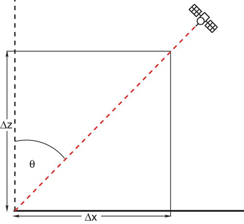
The viewing geometry of a so-called nadir sounder is illustrated schematically in . The latitude/longitude of the intersection of the instrument’s view with the Earth’s geoid is usually provided as geo-location information in the satellite data. When calculating observation equivalents from model fields, current practice at NWP centres is to first interpolate the model fields horizontally to this single latitude/longitude location, and to then perform radiative transfer calculations with the resulting profile. This profile is hence extracted along the black line in . For non-zero zenith angles, however, the instrument’s view slants through the atmosphere (see the red line in ), as given by the satellite’s zenith and azimuth angles. Effectively, this means that for higher peaking channels the current practice extracts the model information at the wrong place, and the displacement is most relevant for larger zenith angles and for channels whose weighting functions peak higher in the atmosphere. For example, for a lower stratospheric channel peaking around 16 km and viewing the Earth with a zenith angle of 60°, the weighting function peak will be displaced by around 28 km, and the stratospheric tail of the weighting function will experience even larger displacements. While the displacements are not large compared to the resolution of today’s global NWP models, the error can be avoided by making better use of the model atmosphere during the horizontal interpolation. Note that the slanted viewing geometry also means that the path through a given atmospheric layer is longer, and this aspect is already taken into account by appropriately scaling the optical depth in the radiative transfer calculations
Figure 1. Schematic illustration of the satellite viewing geometry, viewing a location on Earth with a zenith angle of along a slanted path through the atmosphere (red). The vertical profile currently used for radiative transfer calculations is indicated in black.
In the present work, we have modified the spatial interpolation used in the ECMWF assimilation system to instead extract the profile along the satellite’s viewing path (ie, the red line shown in ). We simplify the calculation of the viewing path by assuming a plane-parallel atmosphere and neglecting any bending resulting from density gradients in the atmosphere. These simplifications are justified given the relatively small spatial scales involved. The viewing path is then described through the following relationship between the geometric height and the corresponding displacement in the azimuthal plane
, given a satellite zenith angle
:
For the largest zenith angles encountered in the present study and the current model top of around 90 km, the maximum displacement is around 160 km. The slanted profile resulting from the interpolation is subsequently used in the radiative transfer calculations in the same way as the previously interpolated vertical profile.
The approach is applied to sounding radiances in clear-sky situations. Note that the slant-path profile is also used to calculate contributions from downwelling radiation reflected at the surface, even though a different profile (e.g. a reflected slanted path) may be more appropriate for this. This is considered acceptable for clear-sky conditions as the additional effect is restricted to lower-peaking surface-sensitive radiances only, for which the effect of horizontal gradients is relatively small. The choice could be revisited, for instance, for the simulation of cloud-affected microwave imager radiances for which these effects are expected to contribute more (e.g., Liu et al., Citation1996; Bauer et al., Citation1998).
The modification of the interpolation uses the technical framework developed for the assimilation of limb radiances or GPS radio-occultation measurements (Bormann et al., Citation2007; Healy et al., Citation2007), and it proceeds as follows: first, we spatially interpolate the model fields to the vertical plane containing the viewing path, given by the geo-location information and the satellite azimuth angle. This interpolation results in n vertical profiles given on the usual forecast model levels, equally spaced spatially in the azimuthal plane. Next, we use the satellite zenith angle to horizontally interpolate the information from the n profiles to the actual viewing path, using (1). In the present work, we found it sufficient to sample the relevant 160 km horizontal extent of the azimuthal plane through profiles with a horizontal spacing of 32 km in all trajectory calculations. Finer sampling was tested, using data from an atmospheric model with TCO1279 spatial resolution (
9.5 km), but this did not provide a benefit. The chosen sampling reflects the broad weighting functions of satellite radiances along the line-of-sight and the spatial scales involved. For the assimilation experiments presented later, analysis increments are calculated at the coarser spatial resolution of TL255 (
80 km), and the use of
profiles with a spacing of 80 km in the minimisation was hence found to be sufficient.
3. Improvements in the simulation of observations
We will first investigate the impact of the slant-path approach on the simulation of observation equivalents from model fields, independent of its use during the assimilation. To do so, we simulated observation equivalents from short-range forecasts from the ECMWF system, once in the conventional way by using a vertical profile extracted at the observation location, and once with taking the slant-path geometry into account. We used the same short-range forecast for both simulations, taken from an ECMWF experiment run at TCO1279 spatial resolution (9.5 km), ie the spatial resolution of the operational ECMWF system since the resolution upgrade on 8 March 2016. We performed these simulations over the period 25 January—24 February 2015. We focus here initially on the impact on ATMS, given the particularly wide swath of this instrument, but other instruments are also considered later. Note that we use ATMS observations here as in the ECMWF system, that is, after averaging observations from 3 neighbouring scan-positions and 3 neighbouring scan-lines (so-called ‘3 × 3 averaging’; see Bormann et al., Citation2013 for further details on the assimilation of ATMS data at ECMWF).
The difference between the two approaches is illustrated in and () for a sample case for two selected channels. As can be seen, the differences can reach almost ±0.5 K for channel 9, a temperature-sounding channel peaking around the tropopause, and locally they even exceed 5 K for channel 15, the top-most temperature sounding channel of ATMS, peaking around 2 hPa. These are sizeable differences in the radiative transfer calculations for these channels that typically show standard deviations of observation minus background departures of around 0.14 K and 0.9 K, respectively. As expected, the differences are mainly confined to the edges of the swath, where satellite zenith angles are largest. Differences also only become sizeable when the observations indicate a significant spatial gradient along the azimuthal direction (which is approximately cross-track for ATMS), such as the gradients over the Gulf of Bothnia for channel 15 in ). In such regions, the differences are, by nature, spatially correlated for scan-positions with larger zenith angles. If the gradients extend for some distances along-track then these consistent differences are present for several thousands of kilometres (see, for instance, regions over Alaska and Greenland in )). Where spatial gradients are small, the differences between the two approaches are also small. It is also apparent that the difference in treating the viewing geometry can lead to differences in the simulations of the opposite sign for two different over-passes, as encountered over Greenland for channel 9 ()).
The dependence of the impact of the slant-path calculations on the zenith angle is further characterised through comparisons with observations in . ) shows very significant reductions in the standard deviation of the differences between observations and model equivalents for the outer-most scan positions of up to 17% for channel 9. The weighting function of channel 9 peaks at around 16 km, so typical displacements around the weighting function peak are about 28 km for the outermost scan-positions according to (1), but the stratospheric tail of the weighting function will be displaced further. Note that these outer scan-positions also show considerably larger departures than the scan-positions with small zenith angles in the conventional approach, whereas this effect is much reduced when the viewing geometry is better taken into account. It appears that the conventional approach introduces a sizeable error in the observation operator calculations for these observations. The impact is qualitatively the same for all temperature-sounding channels, but the upper stratospheric channels still show some increase in the standard deviations for the outer scan-positions even when the slant path geometry is taken into account.
Figure 2. (a) Observed brightness temperatures [K] for ATMS channel 9 for a 12-hour period around 25 January 2015 00UTC. (b) Difference in the radiative transfer simulations from short range forecasts with and without taking the slant-path effect into account, for the observations shown in a). Note that only differences with an absolute value larger than 0.1 K are shown. (c) As a), but for channel 15 of ATMS. (d) As (b), but for the observations shown in (c). Note that only differences with an absolute value larger than 0.5 K are shown here.
![Figure 2. (a) Observed brightness temperatures [K] for ATMS channel 9 for a 12-hour period around 25 January 2015 00UTC. (b) Difference in the radiative transfer simulations from short range forecasts with and without taking the slant-path effect into account, for the observations shown in a). Note that only differences with an absolute value larger than 0.1 K are shown. (c) As a), but for channel 15 of ATMS. (d) As (b), but for the observations shown in (c). Note that only differences with an absolute value larger than 0.5 K are shown here.](/cms/asset/36adecb2-6297-4569-a14c-bb0241ed084f/zela_a_1272779_f0002_c.jpg)
Figure 3. (a) Standard deviations of differences between observations and short-range forecast equivalents for channel 9 of ATMS as a function of the scan position (labelled here with the average satellite zenith angle). Black indicates the conventional treatment, red indicates statistics for calculations that take the slant-path geometry into account. The statistics cover the period 25 January to 24 February 2015, and are based on data over sea after cloud/rain screening. Biases have been removed based on bias corrections obtained from the underlying assimilation experiment that uses the conventional radiative transfer simulations. (b) As a), but for channel 22 of ATMS, the highest peaking humidity sounding channel.
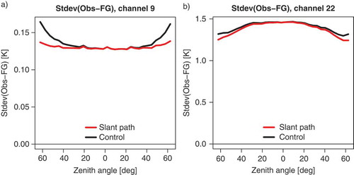
The humidity-sounding channels of ATMS also show a reduction in the standard deviation of the differences between observations and model equivalents for the outer-most scan positions (e.g., ) for channel 22, the highest ATMS humidity sounding channel). The relative reduction in the standard deviations of departures is not as large, partly because the channel is primarily sensitive to the upper troposphere (ie, lower than the temperature-sounding channel shown in )), and partly due to the larger influence of short-range forecast errors. This channel also does not show larger standard deviations for the outer scan-positions in comparison to the central scan-positions when the conventional approach is used. This is most likely because other aspects are dominating the behaviour in this case, for instance, the performance of the cloud detection.
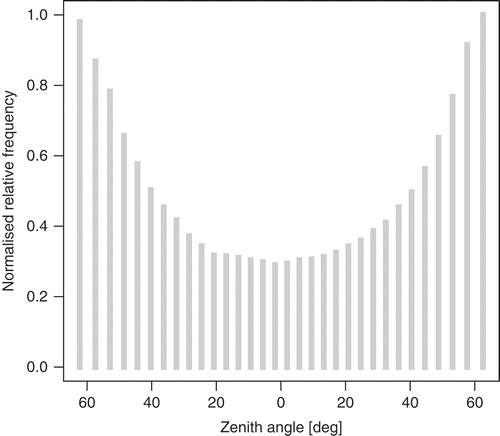
It is worth noting here that after spatial thinning, relatively more observations from the outer scan-positions are selected in the ECMWF system (e.g., ), making the improvements demonstrated here even more relevant. This is because for today’s cross-track sounders the steps between scan-positions are constant in the viewing angle, resulting in spatial sampling that is finer for near-nadir-looking scan-positions and further apart for outer scan-positions. The spatial thinning applied to the data then selects one observation per spatial thinning box, and hence thins out more data where the samples are closer together, that is, for the near-nadir viewing scan-positions.
Figure 4. Normalised relative frequency of observations after geophysical quality control and after spatial thinning as a function of scan-position (labelled here by average zenith angle) for ATMS. The normalised relative frequency shown is the number of observations normalised by the maximum number of observations for any scan position.
For temperature-sounding channels, the influence of performing the slant-path calculations is most relevant at mid and high latitudes, where gradients along the azimuthal direction are largest. This is shown, for instance for channel 9 in ) which highlights considerable reductions in the standard deviation of the differences between observations and simulations from the short-range forecasts in these regions. For the higher humidity sounding channels, the reduction of the standard deviations is most noticeable around the mid-latitude storm-tracks (see, for instance, )). Some small effect on the geographical bias pattern can also be found (e.g., ), and these will lead to small adjustments in the variational bias correction applied to these data during the assimilation. However, the mean changes are relatively small in comparison to the standard deviation of departures or the geographical variation of residual biases pattern that tend to be present after bias correction.
Figure 5. (a) Maps of the difference in the standard deviations of the departures [K] for channel 9 of ATMS between taking the slant-path geometry into account and neglecting the slant-path geometry. Negative values indicate a reduction in the standard deviations from taking the slant-path geometry into account. Statistics are based on simulations from the same short-range forecasts, covering the period 25 January to 24 February 2015, after geophysical quality control. Biases have been removed based on bias corrections obtained from the underlying assimilation experiment that uses the conventional radiative transfer simulations. (b) As (a), but for channel 22.
![Figure 5. (a) Maps of the difference in the standard deviations of the departures [K] for channel 9 of ATMS between taking the slant-path geometry into account and neglecting the slant-path geometry. Negative values indicate a reduction in the standard deviations from taking the slant-path geometry into account. Statistics are based on simulations from the same short-range forecasts, covering the period 25 January to 24 February 2015, after geophysical quality control. Biases have been removed based on bias corrections obtained from the underlying assimilation experiment that uses the conventional radiative transfer simulations. (b) As (a), but for channel 22.](/cms/asset/c1487794-baaa-4f9e-9342-748c0752afa4/zela_a_1272779_f0005_c.jpg)
Figure 6. (a) Maps of the mean difference [K] between neglecting the slant-path geometry and taking it into account in the simulations from short-range forecasts for channel 9 of ATMS on S-NPP. Statistics are based on simulations from the same short-range forecasts, covering the period 25 January to 24 February 2015, after geophysical quality control applied to the underlying observations. (b) As (a), but for channel 22.
![Figure 6. (a) Maps of the mean difference [K] between neglecting the slant-path geometry and taking it into account in the simulations from short-range forecasts for channel 9 of ATMS on S-NPP. Statistics are based on simulations from the same short-range forecasts, covering the period 25 January to 24 February 2015, after geophysical quality control applied to the underlying observations. (b) As (a), but for channel 22.](/cms/asset/6705a768-ffd4-4e1e-92d7-bb70843d04eb/zela_a_1272779_f0006_c.jpg)
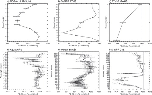
Looking at the effect for other instruments, shows that the slant-path modelling improves the radiative transfer calculations for all sounding instruments considered here, as can be seen from reductions in the standard deviations of observation departures. ATMS and CrIS show the largest benefits from the slant-path modelling, with relative reductions reaching, respectively, 8% and 2% globally. This is the result of relatively wide swaths with large maximum zenith angles, combined with lower noise in the observations, so that these effects are relatively more important. For the other instruments, the reductions in the standard deviations stay typically below 1% globally, but reductions for high zenith angles at higher latitudes are of course significantly larger than that. For AIRS and AMSU-A, these findings are in line with those reported by Joiner and Poli (Citation2005). Another aspect is noticeable in these statistics: In absolute terms, the influence of taking the slanted path into account will be larger the higher the channel peaks in the atmosphere. However, this is not necessarily the case for these relative statistics. Aside from differences in the instrument noise for some of these channels, this also reflects that errors in the short-range forecasts are also larger for channels that peak in the stratosphere, so the relative effect is not as pronounced.
Figure 7. Standard deviation of differences between observations and simulations that take the slant-path geometry into account, normalised by equivalent values obtained with simulations that ignore the slant-path geometry. Values below 100% indicate smaller standard deviations when the slant-path geometry is taken into account. Horizontal bars indicate 95% significance intervals. Statistics are based on data covering the period 25 January to 24 February 2015, after quality control and thinning and after applying bias correction. The six panels show: (a) Statistics for AMSU-A on NOAA-18, (b) ATMS on S-NPP, (c) MWHS on FY-3B, (d) AIRS on Aqua, (e) IASI on Metop-B, and (f) CrIS on S-NPP.
4. Results from assimilation experiments
We will now report on assimilation experiments designed to investigate the effect of taking the slant-path geometry into account. We conducted two assimilation experiments: a Control that neglects the slant-path effect, similar to the ECMWF operational configuration, and a SlantPath experiment, in which the slant-path effect is taken into account for all sounder radiances that are not treated in the all-sky system, that is: AMSU-A, ATMS, MWHS, HIRS, AIRS, IASI, CrIS. Radiances treated in the all-sky system (e.g., microwave imagers, MHS and SSMIS, Geer et al., Citation2014) are currently not considered, as the treatment of the viewing aspects is more complex in cloudy conditions, and the interpolation to the slant-path may also introduce undesirable smoothing of cloud details. The experiments use ECMWF’s 12-hour 4DVAR assimilation system, with a model resolution of TCO639 ( 16 km), an incremental analysis resolution of TL255 (
80 km), and 137 levels in the vertical. The experiments were conducted over the two four-month periods 2 June—30 September 2014 and 2 December 2014–31 March 2015.
The most notable effect for the assimilation experiments is a very significant reduction in the size of the analysis increments, by up to around 10% at higher latitudes and higher levels. This is illustrated in ) which shows zonal mean normalised differences in the standard deviation of analysis increments for wind. Other variables show a very similar pattern. As we did not change the observation errors used in the present experiments, this reduction is an expected effect of the smaller departures for the sounder radiances shown in the previous section. It could of course be argued that the reduction in the observation operator error apparent from the previous section means that the assumed observation error used in these experiments should be reduced accordingly for the affected observations. We have not pursued this here, as the uncertainty in the assumed observation errors is probably larger than the reduction in the observation operator error obtained with the present modification. However, the present change may well contribute to allowing the use of a reduced observation error, for instance for ATMS, and this aspect could be studied further.
The reduction in the size of the increments is not accompanied with sizeable reductions in the FG departures for other assimilated observations. While GPS RO, radiosonde temperatures or the upper-most MHS or SSMIS humidity sounding channel show statistically significant reductions in the affected geographical regions, they remain at most at 0.1–0.2% when averaged over the extra-tropics. These are hence very small improvements (not shown). This may suggest that the impact on the quality of the FG is not very large. Departure statistics for sounder radiances are dominated by the very significant reductions in the size of the FG-departures as shown in , a result of reduced errors in the observation operator, rather than an indication of an improved short-range forecast. Improvements beyond that are difficult to ascertain.
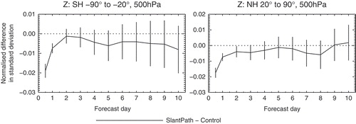
The reduced analysis increments lead to some statistically significant reductions in the size of the forecast errors up to day 3 when each experiment is verified against its own analysis (e.g., )). However, these reductions beyond day 1 are mostly small and generally less than 1% when averaged over the extra-tropics in the troposphere (e.g., ). For the stratosphere, some statistically significant benefits can be found out to the day four forecast at high latitudes. Nevertheless, it appears that the observation operator errors present in the Control due to neglecting the slant-path effect have a relatively limited effect on forecast quality in the medium range.
Figure 8. (a) Zonal means of normalised differences in the root mean squared vector wind analysis increments between the SlantPath experiment and the Control. Blue indicates a reduction in the standard deviation of the increments in the SlantPath experiment compared to the Control. Cross-hatching marks statistical significance at the 95% confidence level. (b) As (a), but for the root mean squared vector error of the 24-hour forecast verified against its own analysis. (c) As (b), but for the 2-day forecast. (d) As (a), but for the 4-day forecast. All statistics cover approximately 8 months over the two seasons combined, with a total of 430 to 468 samples.
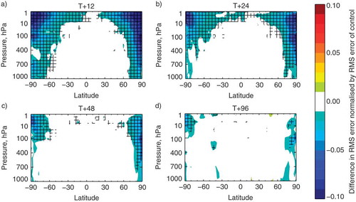
Figure 9. Normalised difference in the standard deviation of forecast errors in the 500 hPa geopotential as verified against each experiment’s own analysis for the Southern Hemisphere extra-tropics (left) and the Northern Hemisphere extra-tropics (right). Vertical bars indicate 95% significance intervals.
5. Conclusions
In this paper we investigated taking the satellite viewing geometry better into account in the observation operator for most sounder radiances in the ECMWF assimilation system (AMSU-A, ATMS, MWHS, HIRS, AIRS, IASI, CrIS). The main findings are:
• Neglecting the slant-path geometry adds a significant error to the radiative transfer simulations for larger zenith angles. Compared to typical background errors and instrument noise contributions, this error is particularly relevant for temperature-sounding channels, especially around the upper troposphere/lower stratosphere, but it is also apparent for humidity sounding channels.
• The slant path effect is most noticeable at mid and higher latitudes for temperature-sounding channels and for the mid-latitudes for humidity-sounding channels.
• Taking the viewing geometry into account for most sounder radiances (without changes to the assigned observation errors) leads to very significant reductions in the analysis increments, particularly at high latitudes and in the upper stratosphere.
• The forecast impact of taking the viewing geometry into account is most noticeable in the stratosphere, particularly at high latitudes, whereas over the troposphere it is primarily limited to the first 3 days and the high latitudes.
Based on the above results, the slant-path effect is taken into account for clear-sky sounder radiances in the operational ECMWF system since 22 November 2016.
The present study is an example of making better use of the full 3-dimensional description of the atmosphere available in an assimilation system, which leads to clear benefits in the simulation of observation-equivalents. However, the medium-range forecast impact of this modification is rather small, suggesting that the current practice of neglecting the slant-path effect is not a major limitation. At the same time, there are aspects that have not been studied here, and they could further enhance the forecast impact: 1) The reduction in the observation operator error achieved here has not been reflected in the assigned observation errors, which have been left unaltered. This is partly because the observation errors assigned in these experiments do not explicitly aim to model the statistical properties of this effect (e.g., through a scan-position-dependent parameterisation), and partly because the uncertainty in the assigned observation errors is considered larger than the reduction in the observation operator error achieved here. Nevertheless, it is clear that at least for some instruments such as ATMS, the error due to neglecting the slant-path effect is considerable for certain conditions, and the elimination of this error source should help to be able to assign lower observation errors in the future. This may lead to more benefits in terms of forecast impact. 2) The slant-path effect has not been taken into account for instruments treated in the all-sky system, that is MHS, SSMIS, and the microwave imagers. The treatment of 3-dimensional effects around clouds is more complex, and can lead to differences of several K for microwave imagers (e.g., Liu et al., Citation1996). Particularly, a better treatment of the slant-path effect for the downwelling radiation reflected at the ocean surface is likely to be needed in these cases, for instance by using a reflected slant-path (e.g., Liu et al., Citation1996), and this could be investigated further. 3) The slant-path effect is currently not applied to any conical scanner such as SSMIS (since these are treated in the all-sky system), but the relatively large and approximately constant zenith angle of 53.1° means that the effect will be particularly noticeable for sounding channels on these instruments. Especially the upper atmosphere temperature sounding channels on SSMIS would benefit, as some of these peak as high as 65 km height. Note that these channels are currently not assimilated in the ECMWF system, but could be considered in the future.
It is worth putting the reductions in the observation operator error for sounder radiances seen here into context with other observation operator uncertainties. For microwave sounders, the channel pass-band characteristics add a considerable potential uncertainty, as highlighted, for instance, by Lu and Bell (Citation2014). In addition, uncertainties in the spectroscopy or line-shape modelling can introduce errors, as has been noticeable, for instance, when considering different spectroscopy for hyperspectral infrared instruments (e.g., Bormann et al., Citation2009; Matricardi, Citation2009; Lupu et al., Citation2015). Many of these radiative-transfer related uncertainties, however, mostly lead to considerable air-mass dependent biases. The effect on statistics after bias correction tend to be fairly small for revised channel pass-bands or updated spectroscopy, with changes typically of the order of less than 1% in terms of the global standard deviation of background departures. Compared to this, the overall reductions found in the present study are quite considerable.
Given increasing refinements in the model representation of the atmosphere and smaller errors in short-range forecasts, it is expected that making better use of the full 3-dimensional description of the atmosphere will receive growing attention in the future. A number of avenues could be pursued in this context. For instance, observation operators for sounder radiances could take into account the spatial characteristics of the satellite footprint, in order to better match the representativeness of the model and observations. In the case of all-sky assimilation, the viewing geometry can have considerable effects around clouds, and local 3-dimensional radiative transfer calculations may offer benefits in certain situations. It is expected that these aspects will also lead to further refinements in the treatment of spatial representativeness errors which are closely linked to the present work.
Acknowledgements
The technical framework to account for spatial structure in the observation operator was initially developed by Mats Hamrud and more recently substantially re-designed by Alan Geer.
Disclosure statement
No potential conflict of interest was reported by the author.
References
- Andersson, E., Pailleux, J., Thépaut, J.-N., Eyre, J. R., McNally, A. P.et al. 1994. Use of cloud-cleared radiances in three/four-dimensional variational assimilation. Q. J. R. Meteorol. Soc. 120, 627–653. DOI:10.1002/qj.49712051707.
- Bauer, P., Schanz, L. and Roberti, L. 1998. Correction of three-dimensional effects for passive m icrowave remote sensing of convective clouds. J. Appl. Meteor. 37, 1619–1632. DOI:10.1175/1520-0450(1998)037<1619:COTDEF>2.0.CO;2.
- Bormann, N., Fouilloux, A. and Bell, W. 2013. Evaluation and assimilation of ATMS data in the ECMWF system. J. Geophys. Res.118, 12,970–12,980. DOI:10.1002/2013JD020325.
- Bormann, N., Healy, S. B. and Hamrud, M. 2007. Assimilation of MIPAS limb radiances in the ECMWF system. II: Experiments with a 2-dimensional observation operator and comparison to retrieval assimilation. Q. J. R. Meteorol. Soc. 133, 329–346. DOI:10.1002/(ISSN)1477-870X.
- Bormann, N., Salmond, D., Matricardi, M., Geer, A. and Hamrud, M., 2009: The RTTOV-9 upgrade for clear-sky radiance assimilation in the IFS. Technical Memorandum 586, ECMWF, Reading, UK, 26 pp. Online at www.ecmwf.int/publications/library/do/references/list/14
- Geer, A., Baordo, F., Bormann, N. and English, S., 2014: All-sky assimilation of microwave humidity sounders. ECMWF Technical Memorandum 741, ECMWF, Reading, U.K., 57 pp.
- Healy, S., Eyre, J., Hamrud, M. and Thépaut, J.-N. 2007. Assimilating GPS radio occultation measurements with two-dimensional bending angle observation operators. Q. J. R. Meteorol. Soc. 133, 1213–1227. DOI:10.1002/(ISSN)1477-870X.
- Joiner, J. and Poli, P. 2005. Note on the effect of horizontal gradients for nadir-viewing microwave and infrared sounders. Q. J. R. Meteorol. Soc. 131, 1783–1792. DOI:10.1256/qj.04.125.
- Laroche, S. and Sarrazin, R. 2013. Impact of radiosonde ballon drift on numerical weather prediction and verification. Weather and Forecasting. 28, 772–782. DOI:10.1175/WAF-D-12-00114.1.
- Liu, Q., Simmer, C. and Ruprecht, E. 1996. Three-dimensional radiative transfer effects of clouds in the microwave spectral range. J. Geophys. Res. 101(D2), 4289–4298. DOI:10.1029/95JD03421.
- Lu, Q. and Bell, W. 2014. Characterizing channel center frequencies in AMSU-A and MSU microwave sounding instruments. J. Atmos. Oceanic Technol. 31, 1713–1732. DOI:10.1175/JTECH-D-13-00136.1.
- Lupu, C., Matricardi, M. and McNally, A., 2015: Monitoring infrared satellite radiance biases using the ecmwf model. In Poster presented at the 20th international TOVS study conference, Lake Geneva, Wisconsin, US, CIMSS, University of Wisonsin, Madison, US, Online at http://cimss.ssec.wisc.edu/itwg/itsc/itsc20/program/PDFs/28Oct/session2b/2p_09_lupu.pdf
- Matricardi, M. 2009. Technical note: An assessment of the accuracy of the RTTOV fast radiative transfer model using IASI data. Atmos.Chem.Phys. 9, 6899–6913. DOI:10.5194/acp-9-6899-2009.
- Poli, P., Joiner, J. and Lacroix, D., 2005: Application of radiative transfer to slanted line-of-sight geometry and evaluation with AIRS data. In Proceedings of the 14th International TOVS Study Conference, Beijing, China, 6.4 pp. Online at: cimss.ssec.wisc.edu/itwg/itsc/itsc14/proceedings/6_4_Poli.pdf
- Saunders, R., Matricardi, M. and Brunel, P. 1999. An improved fast radiative transfer model for assimilation of satellite radiance observations. Q. J. R. Meteorol. Soc. 125, 1407–1426. DOI:10.1002/qj.1999.49712555615.