
Abstract
The thermohaline stream function has previously been used to describe the ocean circulation in temperature and salinity space. In the present study, the Lagrangian thermohaline stream function is introduced and computed for northward flowing water masses in the Atlantic Ocean, using Lagrangian trajectories. The stream function shows the water–mass transformations in the Atlantic Ocean, where warm and saline water is converted to cold and fresh as it flows from to
. By analysing the Lagrangian divergence of heat and salt flux, the conversion of temperature is found to take place in the Gulf Stream, the upper flank of the North Atlantic subtropical gyre and in the North Atlantic Drift, whereas the conversion of salinity rather occurs over a narrower band in the same regions. Thus, conversions of temperature and salinity as shown by the Lagrangian thermohaline stream function are confined to the same regions in the domain. The study of a specific, representative trajectory shows that, in the absence of air–sea interactions, a mixing process leads to the conversion of temperature and salinity from warm and saline to cold and fresh, and that this process is confined to the North Atlantic subtropical gyre. However, to define and to understand this process, further investigation is needed.
1. Introduction
The world ocean plays a crucial role for our climate system, influencing global temperatures with its transport of vast amounts of heat and freshwater. In particular, the North Atlantic Ocean and its transport of heat to high latitudes is of great significance for the climate in Europe (Rhein et al., Citation2013).
The interocean circulation is commonly illustrated with the Conveyor Belt circulation, which connects the Atlantic, Pacific and Indian Oceans (Broecker et al., Citation1991; Talley, Citation2011). In the Southern Ocean, a cold and saline deep current flows eastward around Antarctica, and enters the Indian and Pacific Oceans. In both basins, the water upwells towards the surface as it warms. The warm surface water flows back towards southern Africa where it enters the Atlantic Ocean. The Atlantic Ocean is more saline than the Pacific or Indian Ocean, thus the salinity increases following a water parcel. Approaching the northernmost parts of the Atlantic Ocean, the water cools as a result of heat release to the atmosphere. Eventually, in the Labrador Sea and the Greenland Sea, the water convects to deeper levels and continues southward back to the Southern Ocean, thus closing the Conveyor Belt circulation. The Atlantic branch of this overturning circulation is known as the Atlantic meridional overturning circulation (AMOC) (Kuhlbrodt et al., Citation2007).
The Conveyor Belt circulation is driven mainly by atmospheric winds and density gradients in the ocean. Through air–sea interactions, heating and cooling change the ocean’s temperature distribution, whereas precipitation and evaporation change the salinity distribution. Changes in temperature and salinity generate density gradients, which drive an overturning circulation commonly referred to as the thermohaline circulation (Talley, Citation2011).
The wind-driven circulation is forced by atmospheric winds that set the upper layer of the ocean into motion through frictional Ekman transports. This circulation results in subtropical, subpolar, and equatorial gyres, which are strongest at the surface (Talley, Citation2011).
Both the wind-driven circulation and the thermohaline circulation are parts of the Conveyor Belt circulation; however, the usage of these definitions is sometimes mixed and thus misleading. In the present study, the Conveyor Belt circulation refers to the large-scale circulation in the world ocean, which results from both the thermohaline circulation and thewind-driven circulation. It is also important to recognize that even though the thermohaline circulation is driven by temperature and salinity changes, the wind-driven circulation can result in changes in temperature and salinity, and the two circulations are thus intimately connected (Marshall and Plumb, Citation2013).
The water paths in the ocean, from the surface down to deeper levels, can be traced using the concept of water masses. The ocean can be subdivided into water masses defined as bodies of water with certain properties caused by specific processes (Talley, Citation2011). They are formed in specific regions and are transported with the oceanic circulation and further mixed or consolidated with other water masses. Eventually, they decay or transform into new water masses (Emery, Citation2003). The definition of water masses makes it possible to trace water in the zonal, meridional and vertical directions, and from their specific characteristics it is possible to identify them in TS-space (Tomczak, Citation1999), thus connecting the ocean circulation with the temperature and salinity distribution in the ocean.
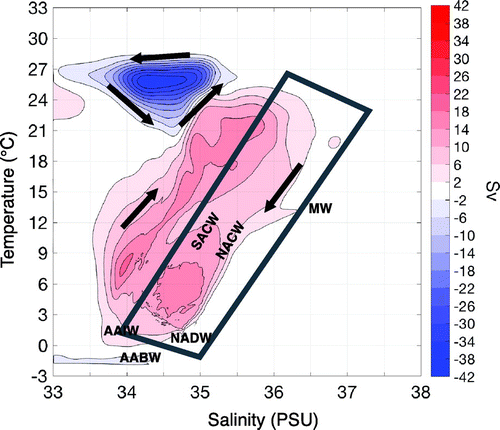
Döös et al. (Citation2012) and Zika et al. (Citation2012) introduced the thermohaline stream function, which describes the entire ocean circulation, including both the wind-driven circulation and the thermohaline circulation, in TS-space. This stream function shows the conversion of temperature and salinity through the whole ocean interior, including both deep and surface waters. The authors used different models and model resolutions, but generated similar results. The thermohaline stream function displays three circulation cells in TS-space, as shown in Fig. . The ‘Conveyor Belt cell’ (red) and the ‘Tropical cell’ (upper blue) dominate the circulation in TS-space. The ‘Polar cell’ (lower blue) only spans a small temperature and salinity interval, but covers high latitude waters both in the Southern Ocean and in the Arctic (Martin et al., Citation2013; Groeskamp et al., Citation2014b; Kjellsson et al., Citation2015). However, it should be noted that the cells might be overlapping, and could thus individually span larger ranges of temperature and salinity than shown here.
Figure 1. The Eulerian thermohaline stream function, computed as described by Döös et al. (Citation2012). The contour interval is 4 Sv (), where red represents clockwise and blue anticlockwise. The most common water masses found in the Atlantic Ocean are marked with their abbreviations at their TS-space characteristics (Talley, Citation2011). SACW, NACW = South and North Atlantic central waters, MW = Mediterranean water, AAIW = Antarctic intermediate water, NADW = North Atlantic deep water and AABW = Antarctic bottom water. The marked area is suggested to represent the circulation of the Atlantic Ocean in the thermohaline stream function.
Groeskamp et al. (Citation2014a) constructed a diathermohaline stream function, which is the stream function introduced by Döös et al. (Citation2013) and Zika et al. (Citation2012) together with a local stream function. This local stream function arises from seasonal movement of isohalines and isotherms, in the absence of geographical displacements. The diathermohaline stream function thus describes the total conversion of temperature and salinity. In a second paper, Groeskamp et al. (Citation2014b) constructed a similar stream function, using surface fluxes and diffusive mixing, pointing out a direct relation between the diathermohaline stream function and these processes.
The stream function shows the ocean circulation in TS-space, but lacks information on the geographical position of the conversion of temperature and salinity. To identify this, both Döös et al. (Citation2012) and Zika et al. (Citation2012) undertook a latitude–longitude reprojection of a specific stream layer in the Conveyor Belt cell and the Tropical cell; this to define the TS-circulation in the ocean interior. They suggested that the Tropical cell illustrates the water–mass transformation in the upper Pacific Ocean near the equator, whereas the Conveyor Belt cell reflects the Conveyor Belt circulation. The lower, cold part of the Conveyor Belt cell represents the cold deep waters found in the Southern Ocean, which are transported into the Pacific and Indian Oceans. In the interior of both these basins, the water upwells and increases its temperature, which is reflected by the left-hand side of the Conveyor Belt cell. As the water subsequently continues into the Atlantic Ocean, it increases its salinity, and can thus be traced in the upper part of the cell. Further on, as the water approaches the northern parts of the Atlantic Ocean, it cools and gets fresher, which is shown by the right-hand side of the Conveyor Belt cell. Döös et al. (Citation2012) suggested that this cooling and freshening arise from air–sea interactions as the water crosses the Atlantic Ocean. However, the method used to trace the water in geographical space might not be sufficient to understand the water–mass transformations that the thermohaline stream function describes. Thus, a method to trace the northward flow in the Atlantic Ocean in TS-space is necessary to determine the mechanism driving the water–mass transformations there.
An advantage with the thermohaline stream function is that water masses and their transformations are traced as a stream function in a single diagram. In Fig. , the most common water masses found in the Atlantic Ocean are marked with their abbreviations (Talley, Citation2011). Most research on water masses in the Atlantic Ocean focuses on the North Atlantic deep water (NADW), which is formed in the northern parts of the Atlantic Ocean and is suggested to play a significant role to the ocean circulation. However, other water masses might be equally important. The North and South Atlantic central waters (NACW, SACW) are formed in the Atlantic Ocean. These waters, which span a large range of temperatures and salinities in TS-space (Emery, Citation2003), are formed by subduction below the mixed layer in the subtropical convergence zone, driven by Ekman pumping (Tomczak, Citation1999).
In the present study, the aim is to describe the Atlantic Ocean’s contribution to the Conveyor Belt circulation displayed by the thermohaline stream function. This is done using Lagrangian trajectories simulated with the trajectory code TRACMASS (Döös et al., Citation2013). Using Lagrangian trajectories allows for analysing specific components of a larger circulation (Blanke et al., Citation1999; Döös et al., Citation2008; Thomas et al., Citation2015). In this study, they allow for separating water–mass transformations in the Atlantic Ocean from the rest of the world ocean in TS-space.
Döös et al. (Citation2012) and Zika et al. (Citation2012) suggested that the right-hand side of the Conveyor Belt cell (grey-marked area in Fig. ) reflects a cooling and freshening of the northward transport in the Atlantic Ocean. Using Lagrangian trajectories, the Lagrangian thermohaline stream function pertaining to these waters can be computed.
A further aim is to determine the geographical positions of temperature and salinity changes of the northward transport in the Atlantic Ocean. Do the water–mass transformations occur through the whole interior or can they be traced to a specific location?
Finally, the aim is to determine what drives the changes of temperature and salinity in the Atlantic Ocean. Are air–sea interactions the most pronounced processes changing the waters properties, as suggested by Döös et al. (Citation2012), or do other processes play an important role?
2. Methods
2.1. Lagrangian trajectory code
The TRACMASS code was first developed in the 1990s by Döös (Citation1995) and Blanke and Raynaud (Citation1997), and further extended in 2001 by De Vries and Döös (Citation2001). Using two- or three-dimensional velocity fields from an Ocean general circulation model (OGCM), the TRACMASS scheme follows and computes trajectory paths. In the present study, trajectories are computed offline, i.e. after the OGCM has been integrated and the fields have been saved, which makes it possible to compute more trajectories than can be done online. Following De Vries and Döös (Citation2001), a time-dependent scheme is applied, which means that the differential equations are extended in time and are solved analytically both in time and space. A major advantage with TRACMASS is that the code is mass conserving. Transports are used in the same manner as in the OGCM by integrating linearly between grid cells, and the vertical transport through a grid cell is computed using the continuity equation. Due to mass conservation, simulated trajectories will never hit any solid boundaries, such as the coast and the bottom of the ocean (Döös et al., Citation2013). Temperature, salinity and density are all interpolated in time and space. However, depending on resolution, a trajectory interpolated in geographical space will appear smoother compared to the same trajectory interpolated in tracer space. An example of this would be a trajectory passing a front, in geographical space the trajectory would appear smooth, whereas in TS-space the trajectory will experience a sharp jump, even if interpolated.
2.2. Model data
In the present study, the velocity, temperature and salinity fields integrated using TRACMASS originate from the Earth system model EC-Earth’s (version 2.2) ocean component Nucleus for European modeling of the Ocean (NEMO) version 2. EC-Earth version 2.2 consists of an atmosphere–land surface module, which is coupled to an ocean–sea ice module. The model of the atmosphere is the integrated forecasting system cycle 31r1 (Hazeleger et al., Citation2012). The configuration of the ocean model, NEMO, is ORCA1, which has a resolution and 42 depth levels. It consists of a tri-polar grid, with poles over northern North America, Siberia and Antarctica. Due to the definition of the poles, the resolution close to the equator is a third of a degree, and close to the North Pole the resolution slightly exceeds 1
(Madec, Citation2008). The vertical mixing is set by the Turbulent Kinetic Energy scheme of Gaspar et al. (Citation1990), whereas eddy tracer fluxes are parameterized using the adiabatic mixing scheme of Gent and McWilliams (Citation1990).
2.3. Simulation
The data are based on a historical integration performed with EC-Earth, where the guidelines for the Coupled Model Intercomparsion Project 5 were followed (Taylor et al., Citation2012). At the end of a control simulation of 600 years, the historical simulation was initialized at 1850 using the greenhouse gas concentrations and aerosol forcing from this year. The simulation was then forced by observed greenhouse gas and aerosol concentrations until 2005. In the present study, monthly mean potential temperature, salinity and horizontal velocities (u,v), from the historical years 1850–2005, are used to calculate Lagrangian transports with the TRACMASS scheme. The velocity fields consist of mean velocities and eddy-induced velocities, which are parameterized since NEMO does not resolve eddies (Madec, Citation2008).
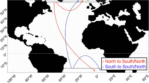
In the present study, particles have been simulated by TRACMASS in a specific domain, covering the Atlantic Ocean, and including the Mediterranean sea, the Black sea and the Baltic sea. A southern boundary was placed at 17S, whereas the northern boundary was at 58
N. The southern boundary is placed at the north end of the Southern Hemisphere subtropical gyre to avoid recirculation in the gyre. The northern boundary is placed at Greenland’s southern tip to separate the Labrador Sea from the Nordic Seas.
Parcels can be followed in specific directions, which makes it possible to limit the analysis to a specific domain. Simulated parcels were initiated through all depths, either along the 17S or the 58
N cross section. The simulation is taken to be completed when parcels reach one of the boundaries, or when the time limit (1000 years) is reached. The TRACMASS scheme makes it possible to trace trajectories in different directions according to their start and end positions, this as a decomposition method. This has been undertaken in previous studies, e.g. Döös et al. (Citation2008) decomposed the Deacon cell, whereas Kjellsson and Döös (Citation2012) did the same for the Hadley and Ferrel cells. This method makes it possible to isolate specific regions and water masses. In the present study, the decomposition of trajectories yields four different pathways in the Atlantic Ocean, shown in Fig. .
Due to the long time periods of overturning in the ocean, the TRACMASS simulation is performed over 1000 years. To overcome the data limitation, 7 cycles are used looping over the 150 years of data based on the 1850–2005 conditions. After 1000 years, only 0.008% of the trajectories remained in the domain, which indicates that 1000 years should be enough to cover the transport in the Atlantic. Looping the EC-Earth data might introduce a sharp transition as each successive loop is initiated, which could affect the results of the trajectories. However, Thomas et al. (Citation2015) undertook a similar Lagrangian analysis using 180 years of data looped over 10 cycles. To determine the effect of looping, the data they introduced had artificial jumps in their simulation and concluded a low sensitivity of the results.
Trajectories were started over the first 12 months to account for seasonal variations. To study the output from trajectories, one trajectory is started in each grid box at the vertical boundary, accounting for the transport in that grid box. It could be proposed that more trajectories should be started in a grid box with a high transport than in a grid box with low transport. However, Thomas et al. (Citation2015) stated that the number of trajectories initiated did not affect the results to a significant extent. Trajectories simulated in the way as has been done here can be thought of as an entire grid box being advected, rather than specific water parcels.
Figure 2. The region of the Atlantic Ocean used in the present study. The grey lines show the southern (17S) and northern (58
N) boundaries delimiting the domain. The blue lines represent the path of water starting at the southern boundary and continuing either back to the southern boundary or to the northern boundary. The red lines represent the path of water starting at the northern boundary, which can go either back to the northern boundary or southwards and exiting the domain at the southern boundary. The grey dashed line is the equator.
2.4. The Lagrangian thermohaline stream function
As noted above, Döös et al. (Citation2012) and Zika et al. (Citation2012) introduced the thermohaline stream function. This describes the volume flow in TS-coordinates, and is computed as the volume transport across an isotherm (isohaline) where the salinity (temperature) is less than S (T) (Döös et al., Citation2012): (1a)
(1b)
is the part of the isothermal surface with temperature T where the salinity is less than S, and
is the part of the isohaline surface with salinity S where the temperature is less than T.
are the surface elements on
and
which point towards higher temperature and salinity,
is the resolved velocity given by the momentum equation plus the eddy-induced velocity (Gent and McWilliams, Citation1990). The volume transport across isohalines is
, whereas across isothermals the volume transport is
, thus the net flow through boundaries is zero Döös et al. (Citation2012).
In the present paper, the Lagrangian thermohaline stream function is defined and computed. The method of computing Lagrangian stream functions was first introduced by Blanke et al. (Citation1999). Following this procedure, the Lagrangian thermohaline stream function is determined by summing over trajectories when they are crossing an isotherm or isohaline. Blanke et al. (Citation2005) undertook a projection of the mass transport from Lagrangian trajectories in TS-space, resulting in a similar thermohaline stream function. However, the authors do not present a mathematical and numerical description of the Lagrangian thermohaline stream function.
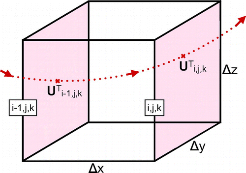
Figure 3. Discretization of the Lagrangian thermohaline stream function. (a) shows a trajectory with transport crossing a grid cell, passing the walls (
, j, k) and (i, j, k). U and V are the transports in zonal and meridional directions located at the wall the trajectory crosses.
is the temperature in the middle of the grid box.
and
are the lengths of the grid box. (b) shows the same trajectory crossing the same grid box as in a, but with superimposed isotherms (red) and isohalines (blue) that lie inside the grid box. The isotherms and isohalines have the indices m and l, respectively. c) shows the same trajectory in TS-space, crossing the same isotherms and isohalines as in panel b, but now the isotherms and isohalines represent a new coordinate system.
and
are the distances between isotherms and isohalines.
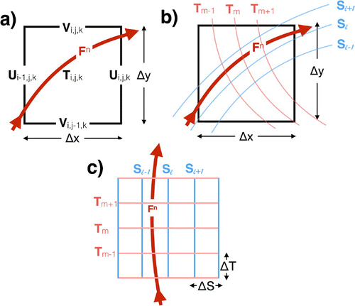
In the present study, each trajectory simulated using TRACMASS is associated with a volume transport, given by the velocity field, the number of trajectories released and the initial area. Since the code is mass conserving, and thus non-divergent, i.e. trajectory transports are kept constant throughout the simulation, Lagrangian stream functions can be computed. Each time a trajectory crosses an isothermal or isohaline, its transport is added to that isosurface. Integrating over trajectories yields (2a)
(2b) Here, m and l are the isothermal and isohaline coordinates, arising from the temperature and salinity of trajectories, respectively.
and
are the transports of a trajectory n across isotherms on constant isohalines and across isohalines on constant isotherms, respectively. By integrating Equation (Equation2a
(2a) ) over isohalines or Equation (Equation2b
(2b) ) over isotherms, the Lagrangian thermohaline stream function is obtained. The discretization of these equations is illustrated by Fig. .
2.5. The Lagrangian divergence of heat and salt flux
To define where trajectories change their temperature and salinity, and connect to the Lagrangian thermohaline stream function, the Lagrangian divergence of heat and salt flux is defined. Equations (Equation3a(3a) ) and (Equation3b
(3b) ) describe the tracer equations for temperature, T, and salinity, S, where an incompressible flow (
) is assumed. The long time means, over the considered time period, of the local rate of change (
) are negligible compared to the rate of change due to advection (
), thus the tracer equations are approximated as Equations (Equation3a
(3a) ) and (Equation3b
(3b) ). These equations are used to define the divergence of heat and salt flux for the trajectories by discretization in the TRACMASS scheme. The derivation and discretization of Equations (Equation3a
(3a) ) and (Equation3b
(3b) ) are described in Appendix 1.
(3a)
(3b) Here,
is the three-dimensional velocity from the momentum equations plus the eddy-induced three-dimensional velocity (Gent and McWilliams, Citation1990),
and
are the diffusion of temperature and salinity, respectively. Q is the heat exchange, changing the temperature of the ocean, whereas
is the excess of evaporation over precipitation and river run-off. If the divergence of heat flux (salt flux) in a grid box is negative, the trajectory looses temperature (salinity) through diffusion, mixing, heat exchange or
, and thus the temperature (salinity) of trajectories decreases in that grid box.
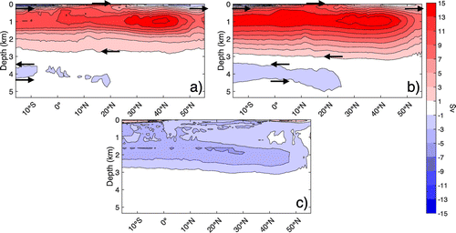
Figure 4. The Atlantic meridional overturning stream function according to (a) the Lagrangian computation with TRACMASS and (b) the Eulerian computation using the first 10 years of data. (c) shows the difference between the Lagrangian and Eulerian stream functions. Panels a, b and c have the same colourbar, with 2 Sv as contour intervals.
3. Results and discussion
The representation of the Lagrangian Atlantic overturning given by all simulated trajectories in all directions (Fig. ) is shown in Fig. a together with the Eulerian AMOC stream function (Fig. b) computed from the same data following Blanke et al. (Citation1999). The discrepancy between the Lagrangian and Eulerian stream functions serves as an approximate estimate of the error in the Lagrangian analysis. However, it is important to recognize that it is not possible to perform a time averaging in the same way for the Lagrangian and Eulerian frameworks. In the Eulerian framework, the stream function shows the mean over all years computed, whereas the Lagrangian framework represents the years trajectories are simulated. Trajectories will stay in the domain over different time periods, which means that all years will be represented differently in the Lagrangian stream function.
The difference between the absolute values of the Lagrangian and Eulerian AMOC is shown in Fig. c, where the maximum discrepancy is found at the surface and is 3.5 Sv. The mean discrepancy is Sv, which generally indicates a stronger Eulerian AMOC than Lagrangian. However, at the surface south of the equator and at the surface at high latitudes, the Lagrangian AMOC shows a stronger overturning.
Other sources of error are mostly due to the sampling of trajectories, the time-looping and atmospheric interactions. The Eulerian stream functions are influenced by the surface divergence due to exchange of water and heat between the ocean and atmosphere. However, the TRACMASS scheme is such that if a trajectory reaches the surface, it is forced back into the middle of the surface grid cell, thus preventing evaporation. This guarantees the code to be completely mass conserving, allowing computation of stream functions. However, by preventing evaporation and precipitation, the transport shown by trajectories will be higher in regions of evaporation, and lower in regions of high precipitation. This is thus what the difference between the Eulerian and Lagrangian AMOC mostly shows at the surface (Fig. c). Due to mixing, the discrepancy can spread below the surface as well.
To decrease the discrepancy, evaporation and precipitation need to be allowed for in the TRACMASS scheme, enough trajectories have to be simulated, covering the total transport, all trajectories have to reach the boundaries and finally no time-looping of trajectories can be allowed for. However, as already stated, zero discrepancy between the Eulerian and Lagrangian stream functions is near to impossible. The method of tracing water masses with TRACMASS gives a satisfying picture of the expected overturning circulation in the Atlantic Ocean.
3.1. The northward transport of the Atlantic Ocean
The Atlantic Ocean is separated into four different pathways according to the direction of the transport, Fig. . The water travelling from north to south and south to south is out of the scope for this paper, and is left for future investigation, and the main focus of the paper is directed towards the water mass going from south to north, i.e. the northward transport in the Atlantic Ocean. However, the water mass going from north to north is shown to play an important role for the cooling and freshening of the northward transport in the Atlantic Ocean. Six trajectories from the north to north water mass are shown as blue in Fig. a in latitude–longitude space and in Fig. b in TS-space. These trajectories originate from the Labrador Sea, where they start as cold and fresh. The water reaches the subtropical gyre, where it re-circulates in the gyre, and gets slightly warmer and saltier before entering the North Atlantic Drift (NAD) (The extension of the Gulf stream and the northern parts of the subtropical gyre) and travels back northwards. In the same figures (Fig. a and b), six trajectories of the northward transport in the Atlantic Ocean are shown (red). These trajectories re-circulate in the subtropical gyre to finally end at the northern boundary as cold and fresh.
Figure 5. Six trajectories going from north to north (blue) and six trajectories going from south to north (red) illustrated in (a) latitude–longitude space and (b) temperature–salinity space.
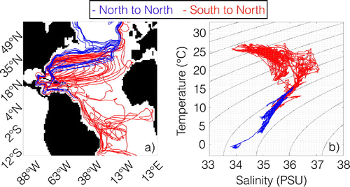
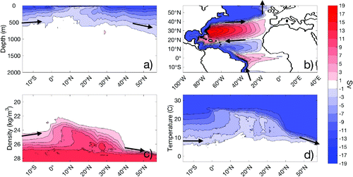
Fig. a shows the Lagrangian Atlantic meridional overturning stream function for the northward transport in the Atlantic Ocean between the southern and the northern boundaries. The total northward transport is found to be 12.3 Sv, which is higher than that found by Blanke et al. (Citation1999) for the northward transport of the warm limb water from S to
N in the Atlantic Ocean. However, in the present study, both the warm and the cold limbs are reflected by the northward transport, and thus a higher value is expected.
At initialization, the water mass is spread in depth as shown in Fig. a, whereas after crossing the equator, most of it rises towards the surface, and further on descends at around 20–N. Fig. b shows the Lagrangian barotropic stream function for the same water mass. A large transport in the North Atlantic subtropical gyre is seen, indicating a strong circulation in the gyre before the trajectories travel northward. Further, Fig. c shows the latitude–density stream function. At around
N, the water rapidly gets denser, except for the already dense water, before continuing northward. This occurs in the northern flank of the subtropical gyre shown in Fig. b. In this region, the water thus changes its properties. It is found that the salinity–depth stream function is rather constant here, whereas the temperature–depth stream function, shown in Fig. d, decreases in temperature in a similar manner as the density. The change in temperature with latitude matches that shown by Blanke et al. (Citation1999) for the northward transport of the warm limb water in the Atlantic Ocean, except for the higher transport shown in the present study.
Figure 6. The northward transport in the Atlantic Ocean computed with the TRACMASS scheme displayed as (a) the Lagrangian meridional overturning stream function, (b) the Lagrangian barotropic stream function, (c) the Lagrangian latitude–density stream function and (d) the Lagrangian latitude–temperature stream function. The contour interval for all stream functions displayed is set to 2 Sv.
3.2. The Lagrangian thermohaline stream function for the northward transport in the Atlantic Ocean
Fig. a shows the Lagrangian thermohaline stream function for the northward transport in the Atlantic Ocean. Since the computation is limited to this region, the boundaries of the stream function are open, resulting in sources and sinks of volume when the initial and end positions of trajectories differ. To illustrate this, the initial and end positions of the trajectories (in TS-space) are shown as green and purple dots in Fig. a. The transport associated with the trajectories is well represented by the Lagrangian thermohaline stream function to the right (i.e. higher salinity) of all sources and sinks.
Consistent with Sverdrup et al. (Citation1942), the initial TS-relation (green dots) has a similar shape as the SACW, AAIW and deep water that can be traced in the South Atlantic Ocean. The SACW has a near-linear shape in TS-space, whereas the AAIW can be traced at the minimum salinity at lower temperatures. The initial points with high temperature and high salinity reflect the water closest to the surface, the properties of which are set by air–sea interactions. The shape of the TS-relationship at the northern boundary (purple dots) indicates a mixture of lower NACW and NADW (Sverdrup et al., Citation1942). The Lagrangian thermohaline stream function shown in Fig. can thus be thought of as the path in TS-space of the water–mass transformation between these water masses in the Atlantic Ocean.
Fig. a shows a small anticlockwise (blue) cell, assumed to be part of the Tropical cell. However, the cells might overlap each other and thus cancel in some areas. This means that the Tropical cell might span a wider range of temperatures and salinities than shown here. However, the focus of the present study is on the Conveyor Belt cell, and thus the question of the importance of the Atlantic Ocean for the Tropical cell is left to further investigation. It is, however, important to recognize that the Tropical cell is a part of the transition of trajectories through the Atlantic Ocean in TS-space. This is seen in Fig. b, where the red trajectories pass through temperatures and salinities covered by both the Tropical cell and the Conveyor Belt cell.
The Conveyor Belt cell (red) shown in Fig. a is clockwise, showing a conversion from warm and saline to cold and fresh on the right-hand side of the cell. This side of the cell is well represented by the trajectories since it is located to the right of all sources and sinks.
Superimposed in Fig. a are isopycnals of and
, computed with the full non-linear equation of state. A water mass can mix both along isopycnals and across (diapycnal mixing). There are different mixing processes that operate in the ocean and cause water–mass conversions both along and across isopycnals, such as vertical mixing, lateral mixing, thermobaricity (a cold parcel is more compressible than a warm parcel) and double-diffusion (Marshall and Plumb, Citation2013).
The Conveyor Belt cell is mostly diapycnal, but in some regions isopycnal. The diapycnal appearance at high temperatures is expected since this water is close to the surface and exposed to air–sea interactions. As temperatures decrease (right-hand side of this cell), specially below C, the stream lines become more isopycnal; however, there is still a diapycnal component. This indicates that there are different processes that both cool and freshen the water mass, e.g. air–sea interaction and mixing/diffusion below the mixed layer.
Fig. b shows the Lagrangian thermohaline stream function for the northward transport in the Atlantic together with superimposed stream lines of the global thermohaline stream function shown in Fig. . The stream lines on the right-hand side of the Lagrangian thermohaline stream function fit the stream lines of the total Conveyor Belt cell, which thus proves that the latitude–longitude reprojection applied by Döös et al. (Citation2012) and Zika et al. (Citation2012) was correct. However, a small difference between the Eulerian and Lagrangian thermohaline stream function is expected since the Lagrangian approach lacks the local effect of moving isothermals and isohalines that are giving rise to the diathermohaline stream function. Groeskamp et al. (Citation2014a) showed that most parts of the local stream function, contributing to the diathermohaline stream function, are related to other areas then the North Atlantic. Thus, the local stream function is not expected to have an important effect on the results shown in the present paper.
Figure 7. (a) The Lagrangian thermohaline stream function computed for the northward transport in the Atlantic Ocean. The contour interval is set to 2 Sv (). The initial positions of trajectories in TS-space are shown as green dots, whereas their end positions in TS-space are shown as purple dots. Superimposed are isopycnals for
(solid) and
(dashed), both with intervals of 1. (b) shows the same Lagrangian thermohaline stream function as in (a), but with the global Eulerian thermohaline stream function (cf. Fig. ) superimposed with contours. Both stream functions have the same colourbar, with a contour interval of 2 Sv.
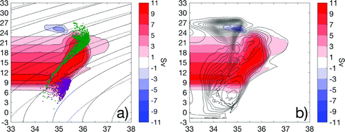
It is noticeable that the Lagrangian stream function only reaches C, whereas the total Conveyor Belt cell covers colder temperatures. This is a consequence of the position of the northern boundary; would trajectories be allowed to continue further northwards, the Lagrangian thermohaline stream function could be expected to cover colder temperatures as well. It is interesting to note that since selected trajectories, thus the stream function, do not cover the coldest and freshest waters, cooling and freshening take place further north of the northern boundary as well. However, since the mixed layer in that region (most northern parts of the North Atlantic) is deep, the cooling and freshening there could be expected to arise mostly from air–sea interactions.
The Lagrangian thermohaline stream function has the same amplitude as the Lagrangian meridional overturning stream function in Fig. a. Blanke et al. (Citation1999) showed that out of a total northward transport of 10 Sv in the Atlantic Ocean, 6 Sv flow through high-salinity regions that are strongly affected by evaporation, and suggested that the remaining 4 Sv can change their salinity through mixing with adjacent waters. However, from the results shown by the Lagrangian thermohaline stream function in the present paper, a separation between mixing and air–sea interactions calls for a more advanced analysis than the usage of the Lagrangian thermohaline stream function alone.
3.3. Temperature and salinity change in geographical space
To be able to quantify where in the Atlantic Ocean the water–mass transformation shown by the Lagrangian thermohaline stream function (cf. Fig. ) takes place, the divergence of heat flux and salt flux is computed for the northward transport of trajectories.
Fig. a shows the divergence of the heat flux, where negative values indicate a decrease in temperature along the trajectories and positive an increase. There is a strong pattern of cooling in the Gulf stream, the northern flank of the subtropical gyre and in the NAD. Fig. b shows the divergence of salinity, where blue represents a decrease and red an increase in salinity. It is noticeable that the salinity changes in a similar pattern as the temperature, however confined to a narrower band along the Gulf Stream, the northern flank of the subtropical gyre and the NAD. Since there is a strong recirculation in the subtropical gyre (Fig. b), trajectories can be expected to pass through the Gulf stream and the lower part of the NAD several times, and thus decrease in temperature and salinity before continuing northwards.
However, the question remains whether the change in temperature and salinity, shown by the Lagrangian thermohaline stream function, arises from air–sea interactions or from internal mixing.
As shown in Fig. a, the water mass originating from the Labrador Sea reaches the northern flank of the subtropical gyre, circuits the gyre and continues north through the Gulf Stream and the NAD. To quantify if a mixing process between the Labrador water and the south to north water mass in the Atlantic Ocean is possible, the divergence of temperature and salinity is computed for the Labrador water.
Fig. c shows the divergence of temperature for the water mass originating from the Labrador Sea. The temperature of this water mass increases in the northern flank of the subtropical gyre, in the Gulf Stream and in the NAD. This indicates that the cold and fresh water from north changes its properties in the same region as the water travelling from south to north. However, the changes are opposite, which indicates mixing rather than atmospheric interactions. Fig. d shows the divergence of salinity for the Labrador Sea water mass. The salinity increases in the same region as it decreases for the water transported northwards, mostly in the upper flank of the subtropical gyre and in the NAD. Mixing of Labrador water and water originating from south is thus a mechanism which changes the properties of both water masses.
3.4. Analysis of one specific, representative trajectory
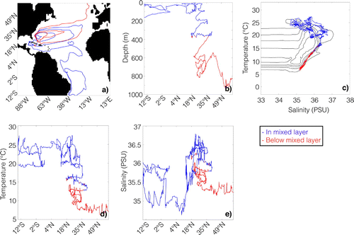
To illustrate how internal mixing, rather than air–sea interactions, drives the changes in temperature and salinity, a specific representative trajectory is chosen. Fig. shows this trajectory in a variety of different projections. As can be seen, the behaviour of the trajectory appears chaotic, thus representing more than one trajectory would make the analysis much more complicated. Therefore, only one trajectory is used, representative in the sense that use of more trajectories, although accounting for a higher transport, would have similar effects on the Lagrangian thermohaline stream function.
Figure 8. The Lagrangian divergence of temperature and salinity computed from trajectories simulated with the TRACMASS scheme. (a) shows the Lagrangian divergence of temperature for the northward transport in the Atlantic Ocean, displayed as MW, whereas (b) shows the Lagrangian divergence of salinity for the northward transport in the Atlantic Ocean, as PSU kg
. (c) shows the Lagrangian divergence of temperature for the water mass starting in north, travelling back north in MW
, whereas (d) shows the Lagrangian divergence of salinity for the same water mass in PSU kg
.
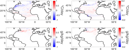
Fig. a shows the trajectory position in longitude–latitude space. When the trajectory is north of ... and below the maximum mixed layer depth, it is coloured red. The maximum mixed layer depth is the maximum mixed layer depth from the 150 years of available data at each point in space. This is an upper bound of the mixed layer depth to ensure that the parts of the trajectory coloured in red in Fig. are always below the mixed layer. However, since the depth of the mixed layer varies with season, being relatively shallow in Northern hemispheric summertime, it is possible that the trajectory is located below the mixed layer more than what is shown by the red colouring in Fig. .
Fig. (b) shows the trajectory in latitude–depth space. As the trajectory reaches the North Atlantic subtropical gyre, it starts to spiral into deeper layers. This is consistent with results shown by Spall (Citation1992), where a trajectory caught in the subtropical gyre spirals downwards in the water column following the structure of density surfaces which arises from the wind-driven circulation. Spall (Citation1992) states that a spiral with depth, as shown here, is driven by the vertical advection of density, horizontal/vertical diffusion and cooling/heating.
According to Burkholder and Lozier (Citation2011), floats released at 700 m, in the region of the subtropical gyre, are most likely to reach high latitudes, compared to floats released at shallower depths. This strengthens the conjecture in the present study of a mixing process below the mixed layer depth leading to a cooling and freshening of water transported northwards. If a parcel needs to reach a certain depth before continuing northwards, it needs to change its density, and thus its temperature and salinity.
Fig. c shows the trajectory in TS-space, together with the Lagrangian thermohaline stream function for the northward transport. When the trajectory is located below the mixed layer, it decreases its temperature and salinity in a near-linear fashion. Comparing with Fig. a, the decrease in the trajectorys temperature and salinity is diapycnal, thus the density of the trajectory increases, indicating a diapycnal mixing.
Recognize that, although not clearly visible in the Fig. c, the changes in temperature and salinity partly retrace their steps during their overall decrease. This fluctuation thus raises new questions about the processes leading to the conversion of temperature and salinity. Is there a specific process giving rise to the linear shape of the trajectory in TS-space?
The shape of the trajectory in TS-space is comparable with the shape of the NACW, which is formed due to subduction in the subtropical gyre (Tomczak, Citation1999). Thus, the trajectory under consideration possibly shows the process leading to the formation of NACW in TS-space.
Fig. d shows the trajectory in temperature–latitude space, whereas Fig. e shows it in salinity–latitude space. Both panels strengthen the suggestion that a change in temperature and salinity in the region of the North Atlantic subtropical gyre takes place, which is driven by a process below the mixed layer. Figure d further shows that a change in temperature in the subtropical gyre takes place on the northern flank, as shown by the Lagrangian divergence in Fig. a, strengthening the suggestion of a mixing with the Labrador water.
Figure 9. One specific trajectory that illustrates the conversion of temperature and salinity in the Atlantic Ocean driven by a mixing rather than air–sea interactions. The trajectory is red if it is below the mixed layer depth, whereas it is blue if it is inside the mixed layer. The mixed layer depth chosen is the deepest mixed layer for all years of data (1850–2005). (a) shows the trajectory in longitude–latitude space, (b) in latitude–depth space, (c) in salinity–temperature space, superimposed on the Lagrangian thermohaline stream function with 2 Sv as contour lines, (d) in latitude–temperature space, and (e) latitude–salinity space.
4. Concluding remarks
In the present paper, the Lagrangian thermohaline stream function has been introduced and computed for the northward transport in the Atlantic Ocean between S and
N. The aim of the paper was to identify the contribution of the Atlantic Ocean to the thermohaline stream function introduced by Döös et al. (Citation2012) and Zika et al. (Citation2012). Lagrangian trajectories are a powerful tool for tracing the northward transport in the Atlantic Ocean and associating it with the thermohaline stream function (Fig. ).
Trajectories showed a mix of SACW, AAIW and deep water at the initialization, which transformed into NACW and NADW when crossing the Atlantic Ocean.
The total northward transport was found to be 12.3 Sv and is reflected in the total thermohaline stream function computed by Döös et al. (Citation2012) as the cooling and freshening branch of the Conveyor Belt cell. Due to the location of the northern boundary, the Lagrangian thermohaline stream function does not reach the lowest temperatures, which thus indicates that a conversion to even colder and fresher water occurs further north as well, possibly arising from air–sea interactions.
On the right-hand side (at high salinities), the Lagrangian thermohaline stream function is both diapycnal and isopycnal, which may arise from air–sea interactions or a mixing process. By introducing the Lagrangian divergence of temperature and salinity, the position of water–mass transformations in geographical space was traced. The cooling is mostly found in the Gulf stream, in the upper flank of the North Atlantic subtropical gyre and in the NAD, whereas the divergence of salinity is confined to a narrower band in the same regions. Using the Lagrangian divergence thus connects the Lagrangian thermohaline stream function to geographical space, increasing our understanding of the Atlantic circulation.
The analysis of one representative trajectory showed that there is a process taking place below the mixed layer which changes the properties of the water mass, but is unaffected by air–sea interactions. However, since the mixed layer depth in the North Atlantic subtropical gyre varies from a few meters to a hundred meters within season, a trajectory can in one instance be located below the mixed layer and in the next inside it again. Separating the total effect of air–sea interactions and other mixing processes needs further investigation.
In the present study, a 1 degree resolution (ORCA1) is used, which is relatively low. However, when studying trajectories, this resolution gives a ‘mean’ path, whereas a higher resolution would give rise to more chaotic trajectories in the geographical space, especially if using an eddy-resolving resolution. However, using an eddy-resolving model would be interesting for the mixing process, shown to take place in the Gulf stream, the upper flank of the subtropical gyre and the NAD. An eddy-resolving resolution would resolve large temperature and salinity gradients, and thus give a smoother trajectory in TS-space. For future work, it would be interesting to perform the analysis of this paper on an eddy-resolving model. However, the drawback of this would be that a climate model no longer can be used, and thus the time resolution would be affected.
To be able to quantify the mixing taking place in the Gulf Stream and in the NAD, showed by the representative trajectory and the Lagrangian divergence, a more specific analysis of the processes giving rise to this mixing is suggested. At the same time, it would be interesting to use the same Lagrangian approach, as used in the present paper, to investigate if similar processes are giving rise to temperature and salinity changes in the rest of the world ocean. This to understand the remaining parts of the Conveyor Belt and how this is illustrated by the Thermohaline stream function.
Acknowledgements
The authors wish to thank Aitor Aldama Campino for constructive comments to the present study, and his help in programming the Eulerian stream functions.
Additional information
Funding
Notes
No potential conflict of interest was reported by the authors.
Related Research Data
References
- Blanke, B. and Raynaud, S. 1997. Kinematics of the Pacific equatorial undercurrent: An Eulerian and Lagrangian approach from GCM results. J. Phys. Oceanogr. 32, 797–830.
- Blanke, B., Arhan, M., Madec, G. and Roche, S. 1999. Warm water paths in the equatorial Atlantic as diagnosed with a general circulation model. J. Phys. Oceanogr. 29, 2753–2768.
- Blanke, B., Arhan, M. and Speich, S. 2006. Salinity changes along the upper limb of the Atlantic thermohaline circulation. Geophys. Res. Let. 33, L06609.
- Broecker, W. S. and co-authors. 1991. The great ocean conveyor. Oceanography 4(2), 79–89.
- Burkholder, K. C. and Lozier, M. S. 2011. Subtropical to subpolar pathways in the North Atlantic: Deductions from Lagrangian trajectories. J. Geophys. Res. 116, C07017.
- De Vries, P. and Döös, K. 2001. Calculating Lagrangian trajectories using time-dependent velocity fields. J. Atmos. Ocean. Technol. 18, 1092–1101.
- Döös, K. 1995. Interocean exchange of water masses. J. Geophys. Res. 100, 13499–13514.
- Döös, K., Nycander, J. and Coward, A. C. 2008. Lagrangian decomposition of the Deacon Cell. J. Geophys. Res. 113, C07028.
- Döös, K., Nilsson, J., Nycander, J., Brodeau, L. and Ballarotta, M. 2012. The world ocean thermohaline circulation. J. Phys. Oceanogr. 42, 1445–1460.
- Döös, K., Kjellsson, J. and Jönsson, B. 2013. TRACMASS -- A lagrangian trajectory model. In: Preventive Methods for Coastal Pollution: Towards the Use of Ocean Dynamics of pollution Control (eds. T. Soomere and E. Quak) chap. 7. Springer International Publishing, Switzerland, pp. 225–249.
- Emery, W. J. 2003. Water types and water masses. In: Encyclopedia of Atmospheric Sciences. 2nd ed. (eds. J.R. Holton, J.A. Curry and J.A. Pyle). Elsevier, Atlanta, GA, pp. 1556–1567.
- Gaspar, P., Gregoris, Y. and Lefevre, J. M. 1990. A simple eddy kinetic energy model for simulations of the oceanic vertical mixing. Tests at station Papa and long-term upper ocean study site. J. Geophys. Res. 95, 116179–16193.
- Gent, P. R. and McWilliams, J. C. 1990. Isopycnal mixing in ocean circulation models. J. Phys. Oceanogr. 20, 150–155.
- Groeskamp, S., Zika, J. D., McDougall, T. J., Sloyan, B. M. and Laliberté, F. 2014a. The representation of ocean circulation and variability in thermodynamic coordinates. J. Phys. Oceanogr. 44, 1735–1750.
- Groeskamp, S., Zika, J. D., Sloyan, B. M., McDougall, T. J. and McIntosh, P. C. 2014b. A thermohaline inverse method for estimating diathermohaline circulation and mixing. J. Phys. Oceanogr. 44, 2681–2697.
- Hazeleger, W. and co-authors. 2012. EC-Earth V2.2: Description and validation of a new seamless earth system prediction model. Clim. Dyn. 39, 2611–2629.
- Kjellsson, J. and Döös, K. 2012. Lagrangian decomposition of the Hadley and Ferrel cells. Geophys. Res. Lett. 39, L15807.
- Kjellsson, J. and co-authors. 2015. Model sensitivity of the Weddell and Ross seas, Antarctica, to vertical mixing and freshwater forcing. Ocean Model. 94, 141–152.
- Kuhlbrodt, T., Griesel, A., Montoya, M., Levermann, A., Hofmann, M. and co-authors. 2007. On the driving processes of the Atlantic meridional overturning circulation. Rev. Geophys. 45, RG2001.
- Madec, G. 2008. NEMO, the Ocean Engine. Technical Report 27, Institut Pierre-Simon Laplace602 Note du Pole de Modlisation, 217pp.
- Martin, T., Park, W. and Latif, M. 2013. Multi-centennial variability controlled by Southern Ocean convection in the Kiel Climate Model. Clim. Dyn. 40(7–8), 2005–2022.
- Marshall, J. and Plumb, R. A. 2013. Atmosphere, Ocean and Climate dynamics: An Introductory Text. Vol. 21, Academic Press, Cambridge, MA.
- Rhein, M. and co-authors. 2015. Observations: Ocean. In: Climate Change 2013: The Physical Science Basis. Contribution of Working Group i to the Fifth Assessment Report of the Intergovernmental Panel on Climate Change, Cambridge University Press, Cambridge.
- Spall, M. A. 1992. Cooling spirals and recirculation in the subtropical gyre. J. Phys. Oceanogr. 22, 564–571.
- Sverdrup, H. U., Johnson, M. W. and Fleming, R. H. 1942. The Oceans, Their Physics, Chemistry and General Biology Prentice-Hall, Upper Saddle River, NJ . 1087 pp.
- Talley, L. D. 2011. Descriptive Physical Oceanography: An Introduction, 6th ed. Elsevier, Amsterdam.
- Taylor, K. E., Stouffer, E. J. and Meehl, G. A. 2012. An overview of CMIP5 and the experiment design. Bull. Amer. Meteor. Soc. 93, 485–498.
- Thomas, M. D., Tréguier, A.-M., Blanke, B., Deshayes, J. and Voldoire, A. 2015. A Lagrangian method to isolate the impacts of mixed layer subduction on the meridional overturning circulation in a numerical model. J. Clim. 28, 7503–7517.
- Tomczak, M. 1999. Some historical, theoretical and applied aspects of quantitative water mass analysis. J. Mar. Res. 57, 275–303.
- Zika, J. D., England, M. H. and Sijp, W. P. 2012. The ocean circulation in thermohaline coordinates. J. Phys. Oceanogr. 42, 708–724.
Appendix 1
Numerical computation of the Lagrangian divergence
As noted above, the TRACMASS scheme is mass conserving in the sense that the mass transport of each trajectory is conserved throughout the simulation. This mass transport is given by the initial area, the velocity and the number of trajectories that are released, and can thus be used to compute the divergence of temperature and salinity from trajectories throughout the simulation. Each time a trajectory crosses a grid wall, it either enters or exits a grid box. When passing this grid box, the temperature and/or salinity of the trajectory can change. If the temperature (salinity) of the trajectory decreases during the passage, this means that the temperature (salinity) flux of the trajectory is larger when the trajectory enters the grid box compared to when leaving.
The tracer equation, describing the conservation of temperature (T), can be written as(A1)
Figure A1. Illustration of a trajectory that passes through a grid box crossing the walls (, j, k) and (i, j, k).
is the temperature flux of the trajectory at grid wall i, j, k, whereas
is the temperature flux of the trajectory at
, j, k.
,
and
are the dimensions of the grid box.
Here, is the diffusion of temperature and Q is the heat flux, and they are sources and sinks to the conservation of temperature. By expanding the derivative in Equation (EquationA1
(A1) ), the equation can be rewritten as
(A2)
Since NEMO assumes an incompressible flow, it is possible to assume here. It is also possible to assume that, over the considered time periods, the long time means of the local rate of change (
) are negligible compared to the rate of change due to advection (
), thus the tracer equation, Equation (EquationA2
(A2) ), can be reduced to
(A3)
where is the three-dimensional velocity and T is the temperature. Similarly, the tracer equation can be applied on salinity and using the same assumptions, it is reduced to
(A4)
Here, S is the salinity advected by the velocity field V is the diffusion of salinity and E–P–R is the excess of evaporation (E) over precipitation (P) and river run-off (R).
The left-hand member of Equations (EquationA3(A3) ) and (EquationA4
(A4) ) describes the divergence of temperature and salinity, respectively, and is in the present study used to show where trajectories are affected by diffusion, heat exchange, or E–P–R. The numerical discretization of Equation (EquationA3
(A3) ) is described below; however, for the discretization of Equation (EquationA4
(A4) ), the same procedure can be applied.
First, consider a trajectory entering a grid box through the wall (,j, k) with its temperature flux
, as shown in Fig. . Inside the box, the temperature of the trajectory decreases, and as it exits through the wall (i, j, k) its temperature flux,
, is smaller than the flux at wall (
,j, k). Since the TRACMASS code is mass conserving, the mass transport of the trajectory does not change when crossing the grid box, only the temperature (salinity) flux, and thus temperature (salinity), changes.
The temperature flux of a trajectory across grid wall (i, j, k) is given by; (8a)
(8b)
(8c) Here,
,
and
are the lengths of the grid box in zonal, meridional and vertical directions, respectively.
,
and
are the temperature fluxes of the trajectory.
,
and
are hence the mass transports associated with the trajectories. T is the temperature of the trajectory at this point, and in the previous point. Equations (A5a), (A5b) and (A5c) are applied on all trajectories crossing a grid wall.
The numerical discretization of the left-hand member of Equation (EquationA3(A3) ) can be written as
(A5)
This divergence thus describes the Lagrangian change in temperature, arising from trajectories, for each grid box in the domain.
To quantify the Lagrangian divergence of temperature in a water column, from the bottom to the surface, the integral of Equation (EquationA6(A6) ) is applied as follows,
(A6)
Here, KM is the number of model levels. The two last terms in the equation do not cintribute to the sum since TRACMASS does not allow trajectories to exit or enter through the sea surface and the bottom of the ocean. Further, to express the Lagrangiandivergence of temperature using heat flux, the expression is multiplied with the heat capacity () and density of sea water (
). Finally, to account for the size of the grid box, the expression is divided with
. Thus, using this, the Lagrangian divergence of temperature is expressed as
.
In a similar way, the Lagrangian divergence of salinity can be expressed as a salt flux. Following the same procedure as above, without the heat capacity, the Lagrangian divergence of salinity is expressed as .