
Abstract
Thermal regime and water balance components of 12 lakes located at two different parts of the Antarctic (the Fildes peninsula in the Maritime Antarctic and the Larsemann Hills in the continental Antarctica) were studied using the observations from three field campaigns in 2012–2014. The morphometric characteristics of the studied lakes were updated with GPS/echo-sounding surveys, and changes in the length, width and volume of the lakes were revealed in comparison with the previous surveys. The thermal regime of the lakes was also studied by modelling, applying the lake model FLake, which is widely used in different environmental applications but was tested for the first time in the Antarctic conditions. In contrast to boreal lakes, for lakes in Antarctica the modelling results by FLake appeared to be sensitive to the light extinction coefficient. According to simulations, all lakes were mixed down to the bottom for the whole summer; however, the reasons for this are different for shallow and deep lakes. The sensitivity of different methods to calculate evaporation, by the Dalton-type empirical equation and by the atmospheric surface layer block of FLake, was studied. For endorheic lakes, the sensitivity appeared to be large, up to 47% of the total seasonal water volume change, which assumes that FLake has the potential to be used in hydrological applications to calculate evaporation. Seasonal variations of the volume of the lakes in the continental Antarctica are larger than in the Maritime Antarctic. Usually, small and medium-sized lakes accumulate or redistribute water during the warm season. However, the systems of big lakes also release the stored water through the mechanism of abrupt jumps, which simultaneously cause the inflow into the sea of huge amounts of fresh water during short time intervals.
1. Introduction
Antarctica is home to a large number of lakes. Some of them are sub-glacial, but most are located on the islands and in continental oases. Oases are rather small ice-free regions with particular weather patterns, where most of the human activities in the continent occur. The majority of the lakes in oases are shallow and relatively warm, with fresh or brackish and saline water. Usually, they are located in relief depressions or old marine lagoons (Laybourn-Parry and Wadham, Citation2014). These lakes are mostly fed by the melting of seasonal snow cover and precipitation. There are also big, deep and cold water bodies, which are usually located in tectonic faults or in the vicinity of glaciers (Sokratova, Citation2011). They are fed by the melting of glaciers. Such lakes may stay fully or partially ice-covered even during the summer. Lakes are often a main source of fresh water for polar stations year-round or during the summer.
Thermal regime and water balance are important for specific physical, biological and chemical processes in Antarctic lakes. However, studies in this area are limited due to the remoteness of the continent and the severe climate. Currently, there are numerous narratives about the effects of temperature regime on the lakes’ biocenosis and specific chemical processes in the Antarctic lakes (Laybourn-Parry et al., Citation1992; Mataloni et al., Citation1998, Izaguirre et al., Citation2001) but only a few studies on the modelling of heat balance and thermal regime (Ragotzkie and Likens, Citation1964; Bydder and Holdsworth, Citation1977). Furthermore, the studies of thermal regime of lakes in extreme conditions allow testing of the lake parameterization models and estimation of their robustness in order to support the surface parameterization in climate and numerical weather prediction (NWP) models (Mironov et al., Citation2010). Nowadays, a large number of NWP systems, general circulation and regional climate models include lake parameterization schemes based on the one-dimensional lake model FLake (Mironov et al., Citation2005; Dutra et al., Citation2010; Mironov et al., Citation2010; Salgado and Le Moigne, Citation2010; Martynov et al., Citation2012). However, this lake model has never been tested under South-Polar conditions.
Information about components of the water balance of Antarctic lakes is needed to evaluate the seasonal variability of water resources in inhabited areas and for the planning of human activity. At the moment, only one income term of the lake water balance – namely, precipitation – has been studied in different aspects: specifically, its daily, seasonal and multi-year variability, including climate change projections (Tietäväinen and Vihma, Citation2008; Bromwich et al., Citation2011; Gorodetskaya et al., Citation2015). Information about the water balance components of lakes allows for the evaluation of a freshwater inflow into the sea due to seasonal snow melting. This could be useful for regional oceanographic models, since uncertainties in the inflow estimates may lead to significant model errors (Jenkins et al., Citation2001; Bintanja et al., Citation2015). There are only a few studies of the surface freshwater inflow in Antarctica, and they are devoted only to glacial melting (McConchie and Hawke, Citation2002; Dominguez and Eraso, Citation2007; Doran et al., Citation2008). Also, snow, ice melting and freshwater runoff were studied for mixed snow and blue-ice areas and non-glaciated oases in Antarctica (Chinn, Citation1993; Liston and Winther, Citation2005). However, the role of the lakes in a seasonal distribution of the freshwater inflow has not been extensively studied for the Antarctic coastal regions.
Thermal regime and water balance are connected through the latent heat flux and evaporation (the outcome of the water balance), which have not yet been studied for this region. The measurement of evaporation requires a complex procedure, which is not always possible to organize during the short summer season in remote conditions of Antarctica. The evaporation from water surfaces is thus often assessed by indirect methods (Finch and Hall, Citation2005). There are numerous methods based on the Dalton-type empirical equations for the seasonal and daily values of evaporation (Kohler, Citation1954; Pruitt, Citation1966; Odrova, Citation1978) or based on the mass and energy balance methods (Venäläinen et al., Citation1998; Pienitz et al., Citation2004). The latent heat flux or the evaporation rate can be also known from the lake model simulations forced by standard meteorological observations or by outputs of a NWP model. For example, the lake model FLake may be used for this purpose.
This study aims to improve our knowledge of polar hydrology by evaluating the thermal regime and components of the water balance of Antarctic lakes. The key objectives of the study are (i) to investigate the thermal regime of lakes in the Antarctic from measurements and modelling results and to test how the lake model FLake performs in this region, (ii) to assess different components of the water balance of lakes in Antarctica and changes in their water capacity, and (iii) to explore the connection between the thermal regime and water balance through evaporation for Antarctic lakes.
In the present study, we focus on two regions: the Fildes peninsula of King George Island in the Maritime Antarctic and the Larsemann Hills, Princess Elizabeth Land, in the continental Antarctica. Previous studies reported morphometric and catchment characteristics, water temperature profiles and chemistry measurements for some lakes in these regions (Orlov, Citation1973; Simonov, Citation1973, Citation1977; Gillieson et al., Citation1990; Kaup et al., Citation2001). We use meteorological observations and specific hydrological measurements collected during three summer field campaigns in 2012–2014 on 12 lakes. We present the estimates of the morphological characteristics, as well as the components of the water balance of lakes, and discuss the FLake simulations and the heat balance of Antarctic lakes.
2. Study area
Two locations with different climates were chosen to study the thermal regime and water balance components of lakes (Fig. ). Both sites are located in the vicinity of the polar bases, and the natural regime of some lakes is affected by human activities. Some of the lakes studied provide the water supply for drinking and technical purposes. The first spot is the Fildes peninsula at King George Island, Maritime Antarctic (Fig. , left), and the second is the Larsemann Hills at Princess Elizabeth Land, East Antarctica (Fig. , right). At the Fildes peninsula, the measurement campaign was carried out during January–March 2012. At the Larsemann Hills, two measurement campaigns were carried out, during December–February 2012–2013 and January–March 2014. Temporary gauging sites (Fig. , Table ) were placed on the lakes and their inlet/outlet flows. In this manuscript, in addition to the lake name from Fig. , we use the index of the level gauge from Table to identify each lake.
Fig. 1. Study area and the temporal gauging sites equipped during the field campaigns of 2012–2014.
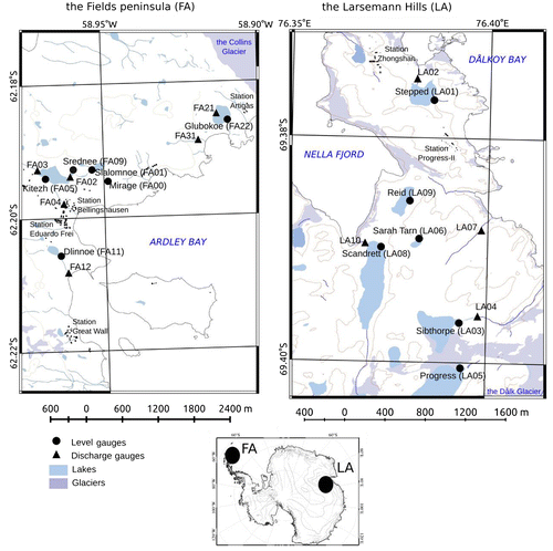
Table 1. Lakes and gauging sites in the study area. For the lakes at the Larsemann Hills, two names are presented: according to Australian topographic map of 1:10000 (AAD: Australian Antarctic Division, Citation2005), and according to Gillieson et al. (Citation1990) if any, together with the index, in parenthesis.
2.1. The Fildes peninsula
The territory of the peninsula is mostly ice-free; only the north-eastern edge is covered by a large glacier (the Collins glacier). The local climate is maritime, with high relative humidity and precipitation. The cyclonic activity over the Atlantic Ocean causes fog, rains and snowstorms, which frequently occur during the summer (Ferron et al., Citation2004); thus, the area is dominated by warm, wet and windy weather. The surrounding landscape is formed by hills with elevations of up to 120 m, while the bedrock is composed by volcanic deposits, mostly consisting of basalts, tuffs and andesites (Simonov, Citation1977). Erosion processes are widespread and are mostly represented by solifluction, cryoturbation and frost weathering, with the thickness of the active layer reaching 0.8–1.0 m during the warm period (Michel et al., Citation2014).
The first studies on the lakes in the Fildes peninsula were carried out at the beginning of the 1970s and summarized by Orlov (Citation1973) and Simonov (Citation1973, Citation1977). About 60 freshwater lakes of different types and origins are located on the Fildes peninsula. Most of the lakes are small and shallow endorheic ponds located in depressions formed by de-glaciation. However, large and deep lakes also exist. During the summer, the lakes are mostly ice-free, and snow melt water is transported by the local streamflow network.
The lake system Slalomnoe–Srednee–Kitezh is located in the vicinity of the Ardley Bay and is oriented from north-west to south-east. The biggest lake in the system, Lake Kitezh (FA05, Fig. a), is located on a tectonic fault. Numerous separate ponds spread over the catchment partially retain snow melt water. The streamflow network on the watershed is presented by two main rivulets. The west creek (FA03) collects snow melt water from an area of 0.16 km2 and has a total length of 750 m. The south creek (FA02) originates from Lake Slalomnoe (FA01) and flows through Lake Srednee (FA09) before reaching Lake Kitezh. The watershed area of the south tributary is 0.61 km2. Outflow from Lake Kitezh occurs year-round through the creek Stancionny (FA04), but its water discharges are usually drastically decreased in the winter (B. Mavludov, personal communication). Lake Kitezh serves as a year-round source of drinking and technical water for the Bellingshausen base (Russia) and Eduardo Frei base (Chile). The pumping station is established about 400 m from the outflow of the Stancionny creek on the artificial reservoir, which allows for accumulating water.
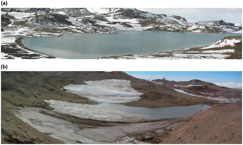
Fig. 2. The landscapes of (a) the Fildes Peninsula with the watershed of Lake Kitiezh (FA05), and (b) the Larsemann Hills with the artificial dam on the watershed of Lake Stepped (LA01).
Shallow Lake Dlinnoe (FA11) is located at the south-east end of the Fildes peninsula, in the depression formed by an ancient lagoon (Simonov, Citation1973). The elevations of the watershed vary from 14 to 45 m above sea level, with a slight incline to the south-east. The excess water is released through the outflow creek existing during the summer season. Lake Glubokoe (FA22) is situated at the north end of the Fildes peninsula, in the vicinity of the Collins ice cap but not directly connected to it. This is the deepest lake in the region, with a relatively small watershed area, and it was formed in a volcano crater (Simonov, Citation1973). Lake Glubokoe is endorheic and is fed by snow melt. The lake water losses consist mostly of evaporation and subsurface outflow through the eastern side (Orlov, Citation1973). Lake Glubokoe supplies the Artigas base (Uruguay).
2.2. The Larsemann Hills
The Larsemann Hills consist of several ice-free peninsulas. The local climate is relatively warm and dry. The weather during summer is usually sunny, with slightly negative air temperatures and low precipitation (Gillieson et al., Citation1990). The precipitation is almost exclusively snow, which is immediately redistributed by a wind. The wind speed is about 7.0 m s−1 in average, but the maximal speed of the wind in the morning/evening can reach up to 40–50 m s−1 in the winter. The land is composed by gneiss and granite rocks; the permafrost layer is located at a depth of 0.2–0.9 m (according to Burgess and Kaup, Citation1997; Kaup and Burgess, Citation2002), reaching up 0.9–1.0 m in the season of 2012–2013. During the summer season, specific hydrological and cryogenic factors affect the local pedogenesis (Mergelov, Citation2014), and the melting water is a strong driver in sediment transportation (Vogt and Braun Citation2004).
More than 150 freshwater lakes, ranging from small ponds to deep glacial water bodies, are located at the Larsemann Hills. The first detailed studies of the local lakes were done by the Australian National Antarctic Research Expeditions (ANARE) in the late 1980s. Thereafter, the basic parameters of the lakes’ physiography, sediments and water chemistry were summarized in the Atlas of Lakes (Gillieson et al., Citation1990). The majority of the water bodies are located in rock depressions formed by glacial erosion. These ultraoligotrophic lakes are fed by snow and ice melt. During the warm season, lakes are partially or fully ice free, and most of them release water into the sea through temporal outflow streams.
Large lakes on the Broknes peninsula (Lake Progress, Lake Sibthorpe and Lake Scandrett/Nella) are mostly fed by melt water from the Dålk glacier, which is situated next to the east corner of the oasis. These lakes are connected through the streams and form the lake system. The ice usually covers more than 60–80% of the surface during the warm period in Lake Scandrett/Nella (LA08) and Lake Progress (LA05). During the warm seasons, Lake Progress is also connected with Lake Sibthorpe (LA03), which in turn has an outflow to the sea through the creek located at the east corner. Lake Progress is used to provide the drinking water to the Progress base (Russia) and Zhongshan base (China); the water is delivered to the stations by vehicles.
At the Larsemann Hills, there are also lakes located on the small depressions that are supplied mostly by snow melt – Lake Stepped (LA01), Lake Sara Tarn (LA06), Lake Reid (LA09) and Lake No Worries (LH69 in Gillieson et al., Citation1990), which is located in the vicinity of the Zhongshan base. Some of these lakes are brackish (Kaup and Burgess, Citation2002). Lake Stepped is located in the depression of the coastal lagoon, and its watershed is mostly composed of local gravels. The western part of the lake is very shallow (up to 1.5 m), while the eastern part has a maximum depth of 5.5 m. The lake is fed by snow melt, and water surplus is released through water leakage and small rivulet (LA02) at the north-east corner of the lake. In the neighbourhood of Lake Stepped, two stations (Zhongshan/China and Progress-II/Russia) are located. The human activities on the watershed involve taking sand from the northern part for the building purposes of Zhongshan base. Also, the melting water from the western part of the catchment is artificially transferred to the lake located in the vicinity of Zhongshan base. For this purpose, a pumping station is installed, and an artificial reservoir with a dam is usually created at the beginning of the warm period (Fig. (b)). Lake Stepped is also used as a year-round technical water supply for the Progress-II base (Russia). Lake Sarah Tarn and Lake Reid are small and brackish endorheic ponds that are fed by snow melt. Outflow episodically occurs from Lake Reid through the stream appearing at the north-west corner of the watershed. Lake Saran Tarn water losses include evaporation from the water surface and water leakage on the north-western side of the lake.
3. Data and methods
3.1. Hydrological, meteorological and morphological observations
The measurement campaign at the Fildes peninsula lasted from 09.01.2012 to 02.04.2012, while two campaigns at the Larsemann Hills lasted from 25.12.2012 to 28.02.2013 and from 03.01.2014 to 10.03.2014. To support the field studies, the following maps were utilized:
| (1) | For the Fildes peninsula: IGM: Instituto Geográfico Militar de Chile and INACH: Instituto Antártico Chileno (Citation1996), Barriga et al., (Citation2001) and North-West Aero-geodesic Corporation of the USSR (Citation1986). | ||||
| (2) | For the Larsemann Hills: maps numbered 13103, 13135, 14077, 14205 and 14076 from the data-set of the Australian Antarctic Data Center (https://data.aad.gov.au/). In the manuscript, we use lake names from these maps for this site, but we also provide the lake names and indexes from Gillieson et al. (Citation1990) in Table . Also, the data of the geodesic survey tracks around the Progress-II base obtained by the Russian Antarctic Expedition during the field campaigns of 2010–2012 were used. | ||||
To evaluate the bathymetry of big lakes, GPS/acoustic sounding surveys on 4–8 crossing tracks were carried out from a small boat, while the lake depth was measured with the Hummingbird 737 equipment.
The temporary level and discharge gauging sites were placed on the lakes and their inlet/outlet streams (Fig. and Table ). At the level gauging sites, the water stage and temperature were measured with daily frequency, usually at the same time for each gauge, using the standard rod and thermometer TM2 (Chikovani, Citation1971). The temperature was measured at a depth of 0.02 m, which was considered as the surface temperature. For Lake Stepped, the water temperature profiles were measured by iButton devices (DS1921G), which were installed on a weighted cord sufficient to keep vertical position and dropped from the pier of the water pumping station for the campaign of 2012–2013. The freeze-up dates were defined by the day when the surface of the lake was completely covered with ice.
The discharge gauging sites were established on the creeks connected with the lakes, as well as on the small rivulets, which collected melting water from the lake-free catchments (FA31 and LA07 in Fig. ). The observations on the gauges included the water stage and discharge, as well as the water temperature and water sampling (not used in this study). The water discharges were measured once per 2–3 days (Table ) using the streamflow velocity micro current meter GR-55 (Chikovani, Citation1971). Stage-discharge curves were then constructed to calculate the daily discharges (Guidelines, Citation1978).
Table 2. Water discharges measured during the field campaigns of 2012–2014 in the outlet/inlet streams, the Field peninsula and the Larsemann Hills.
The meteorological data were obtained from the nearest stations (Fig. , Table ): for the Fildes peninsula, from the station Bellingshausen (89050, 62°12′S, 58°56′W); for the Larsemann Hills, from the station Progress (89574, 69°22′S, 76°23′E). We utilized 6-h observations extracted from the data-set of the British Antarctic Survey (https://legacy.bas.ac.uk/met/metlog).
Table 3. Observed summer climatology for the period of 1968–2010 at the Fildes peninsula, according to the station Bellingshausen (89050), and for the period of 1988–2010 at the Larsemann Hills, according to the station Progress (89574), as well as the observed mean values of the meteorological parameters during the field campaigns of 2012–2014.
3.2. Lake model and forcing data
To study the thermal regime of lakes, we applied the lake model FLake (Mironov et al., Citation2005). This model is widely used in different applications: to investigate various aspects of lake behaviour (e.g. Vörös et al., Citation2010; Golosov et al., Citation2012; Yang et al., Citation2013) and to represent lakes in many global and regional climates and NWP models in a coupled mode (Dutra et al., Citation2010; Eerola et al., Citation2010; Mironov et al., Citation2010; Salgado and Le Moigne, Citation2010; Samuelsson et al., Citation2010). FLake is a two-layer integral (bulk) model considering the temperature profile to contain the upper mixed layer and the underlying thermocline, which are parameterized with the concept of self-similarity (assumed shape). The equation of convective entrainment or the relaxation-type equation in a case of wind mixing is used to describe the evolution of the mixed-layer depth. An exponential approximation of the extinction law is used for the solar radiation transfer. The mixed-layer temperature in FLake is calculated from a diagnostic equation. FLake also contains snow-ice and bottom sediment modules with the same concept to describe the temperature profiles. The main prognostic variables (describing the thermal regime of the water column) are: the mean water temperature, the bottom temperature, the mixed layer depth and the shape factor (the integral of the polynomially approximated temperature profile in the thermocline).
We concentrated on the summer season, typically starting our simulations from the date of ice break-up and running them until the date of ice freeze-up. The best initialization methods were chosen depending on the lake mean depth. For shallow lakes (with a mean depth of less than 1.5 m), we started from the mixed temperature profile, with the temperature equal to the observed water temperature. For lakes with a mean depth larger than 1.5 m, we started from the following initial values: the mixed layer temperature equals the observed water temperature, the mixed layer depth is 1.5 m, the bottom temperature equals the fresh water maximum density temperature (277.13 °K), the shape factor is 0.5, and the mean water temperature is calculated from the main diagnostic equation of FLake. All experiments were started from the first day of the measurements. For the lake depth parameter, we used the mean depth for each lake calculated as the volume divided by the surface area. In our study, the bottom sediment module was switched off because of the short simulation period.
The FLake model contains a module to compute turbulent fluxes as well as evaporation from the lakes surface from the atmospheric forcing data, taking into account the atmospheric stratification due to stability. If no downward longwave radiation fluxes are available in the atmospheric forcing, the model provides an opportunity to calculate them from standard meteorological measurements using a simple parameterization method (Zapadka et al., Citation2001). In addition, the simple parameterization method to calculate atmospheric shortwave radiation fluxes from standard meteorological measurements (based on Girdiuk and Kirillova, Citation1974; Shine, Citation1984) was implemented. It has been shown (Yang et al., Citation2013) that these types of simple parameterization schemes have an error of ca. 10%. Thus, for the atmospheric forcing, the standard meteorological observations from local weather stations (Bellingshausen station for the Fildes peninsula and Progress station for the Larsemann Hills) were used: the screen level temperature and dew point, the screen level wind speed and the octal cloud cover. Observations with a temporal resolution of 6 h were interpolated to 10-min intervals to force the lake model experiments. We use a linear interpolation technique, which can be a source of errors and inaccuracies in simulations. However, the solar radiation fluxes being calculated from the interpolated temperature may contain less errors than the measured and interpolated fluxes themselves. The reason is that the parameterization formulas already contain the diurnal cycle of the solar radiation at the given geographical location.
3.3. Lake water balance equation
To describe the seasonal water balance of lakes we used the following equation:(1)
where V is the lake water volume, t is the time period (equals to the period of observations), P is the precipitation over the lake surface, Yin and Yout are the surface inlet/outlet runoff correspondingly, E is the evaporation from open water surface, Gin and Gout are the subsurface inflow/outflow runoff correspondingly, and W is the water supply for human activity.
The terms of the Equation (Equation1(1) ) were evaluated from the observations from the level gauges (V), the discharge gauges (Yin and Yout) and the nearest meteorological station (P). The daily evaporation from open-water surface (E, mm/day) was estimated using the empirical equation (Odrova, Citation1978):
(2)
where the water vapour pressure at saturation (e0, hPa), the screen level water vapour pressure (e200, hPa) and wind speed (w200, m s−1) are the daily averaged values. For calculation of the water vapour pressure and water vapour pressure at saturation, the standard measurements of the wet bulb temperature and the look-up table from Odrova (Citation1978) were used. The evaporation (E) was also calculated by the surface level module of FLake model (Mironov et al., Citation2005). To evaluate the daily values of evaporation from the lake surface, the ice-covered area was excluded for Lake Scandrett/Nella and Lake Progress since these lakes were partially covered by the ice. The ice-covered surface area of the lake was estimated visually: for Lake Scandrett/Nella, the area was equal to 80% of the total surface area, and Lake Progress was covered by ice over 60% of the total surface area for the season of 2014. We guess that the visual estimations may have accuracy of over 10% of total lake area. In this study, the ice-covered surface area of the lake was used to calculate the seasonal evaporation from the lake’s surface. The terms of subsurface water runoff (Gin and Gout), which are formed mostly by percolated water from snow cover melting were included to the discrepancies of the Equation (Equation1(1) ).
4. Results and discussion
4.1. Lake morphology
For all lakes, the basic morphological parameters (i.e. length, width and surface area) were estimated using (i) the geodesic survey tracks and echo-sounding depth measurements performed during the campaigns of 2012–2014 (Lake Kitezh, Lake Stepped and Lake Progress), and (ii) the digital maps (INACH, Citation1996; AAD, Citation2005). The depth-volume curves were obtained, and the water volume and mean depth were evaluated according to Wetzel and Likens (Citation1991). The method presented by Salo et al. (Citation2010) was used to evaluate the volume for the lakes without bathymetry, and the lake mean depth was calculated from a digital elevation model of the lake catchment (Table ). The obtained mean depth values were further used to provide the parameters for the lake model FLake. In this study, the lakes were classified by volume as follows: (i) small lakes with a volume less than 10,000 m3, (ii) medium sized lakes with a volume ranging from 10,000 to 100,000 m3 and (iii) big lakes with a volume of more than 100,000 m3.
Table 4. Morphology of the lakes according to the historical records and obtained from the surveys of 2012–2014.
In the Fildes peninsula, the length, width, area and volume of Lake Kitezh and Lake Slalomnoe were estimated to be generally less than the historical values provided by Orlov (Citation1973) and Simonov (Citation1973). At the same time, the area, mean depth and volume of Lake Dlinnoe and Lake Glubokoe appeared to be 30–40% greater than the historical values. Such discrepancies may reflect the coarseness of the previous estimates as well as the changes in the lake morphometry due to coastal dynamic processes (Vogt and Braun, Citation2004).
In the Larsemann Hills, our estimates of the lakes’ morphometry were largely in accordance with the surveys by Gillieson et al. (Citation1990) for most of medium-sized lakes (Table ). However, the lake surface areas were estimated to be larger than those from Gillieson et al. (Citation1990) for the large lakes, specifically Lake Progress and Lake Scandrett/Nella.
4.2. Thermal regime of lakes
The thermal regime of lakes was studied using both observations and modelling results from the lake model FLake (Mironov et al., Citation2005). The experiments with FLake were performed to study the temperature regime and to estimate the evaporation over the open-water surface of the lakes. Preliminary experimentation showed that the results are very sensitive to the initialization method and to the model parameters setting. Also, the modelling results appeared to be sensitive to the light extinction coefficient parameter. Fig. shows the evolution of the modelled lake water surface temperature (LWST), with different values of the extinction coefficient varying from 0.2 to 4.0 m−1 together with the observed LWST for two shallow lakes: Lake Kitezh at the Fildes peninsula and Lake Stepped at the Larsemann Hills. The sensitivity of simulation results to the light extinction coefficient is high: the distance between the curves with different values of the extinction coefficient parameter reaches 3 °C for Lake Kitezh and 5 °C for Lake Stepped. As one may expect, the large light extinction coefficient (water turbidity) results in a high simulated LWST. The sensitivity is non-linear: for Lake Kitezh, the change in the extinction coefficient between 1.0 and 4.0 m−1 does not affect the modelling results. Previous studies reported low sensitivity of FLake results to this parameter for boreal lakes (Kourzeneva and Braslavsky, Citation2005) and high sensitivity for warm, deep lakes (Kourzeneva et al., Citation2012). Thus, the high sensitivity found in our experiments is Antarctic-specific. Since light extinction coefficients for lakes were not measured during the campaign, this parameter became a tuning value in our experiments. It was chosen for each lake experimentally to provide the least modelling error (both the bias and RMSE). It varied from 0.2 to 4.4 m−1 for different lakes (see Table ). Although the light extinction coefficient was a tuning value in our experiments, it corresponded to the real water transparency: large and deep lakes, such as Lake Kitezh, Lake Progress and Lake Scandrett/Nella are visually relatively transparent, whereas small and shallow lakes, such as Lake Stepped and Lake Reid are turbid and the light extinction coefficient for them can be much higher (Ellis-Evans et al., Citation1997).
Fig. 3. Results of the sensitivity experiments of the modelled LWST to the light extinction coefficient (E). Lines of different colours show the evolution of the modelled LSWT with different values of E (according to the legend), blue dots show the observed LSWT for the period of the measurement campaign at the Fildes Peninsula for Lake Kitezh (FA05) (a) and at the Larsemann Hills for Lake Stepped (LA01) (b).
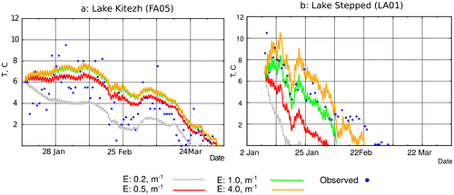
Table 5. Light extinction coefficient values ETable Footnote*, observed and modelled mean and maximum LSWT, model errors, and observed and modelled freeze-up dates for different lakes (for lake morphological parameters, see Table ).
4.2.1. Climatic conditions
During the first eight weeks of the campaign in the Fildes peninsula, the air temperature was slightly positive and varied by 2–3 °C from the seasonal climatology (Table ), and the changes in the temperature often coincided with shifts in the wind speed (Fig. ). The air temperature diurnal cycle was very small (1–2 °C). The air temperature decreased by about –4 °C in the second decade of February (Fig. ); this cooling was caused by the heavy snowstorm. During the next three weeks, the weather was warm and sunny, and the air temperature increased up to 6 °C under calm and clear sky conditions. The air temperature decreased continuously during the third and fourth weeks of March and dropped below zero at the beginning of April. The air was humid, and the dew point was very close to the air temperature. Frequent overcast and stable air temperatures caused the downward longwave radiation flux to be rather large and stable (more than 250 W m−2, with only two drops to 210 W m−2), while the net shortwave radiation to be small (with the day maximum values of 500–700 W m−2 at the beginning of the period) (see Fig. ). The net shortwave radiation showed seasonal decreases during the whole period of observation, dropping to the day maximum value of 250 W m−2 at the end of March. In summary, for the season 2012, the mean values of air temperature, relative humidity, wind speed and cloud cover were close to the observed multi-year mean values (Table ); however, the precipitation amount was low, and the duration of the sunshine was extremely high for this summer.
Fig. 4. Evolution of the meteorological forcing for the lake model FLake for the Fildes Peninsula (from station Bellingshausen) for the period the measurement campaign of 2012, right column, and for the Larsemann Hills (from station Progress) for the period the measurement campaign of 2014, left column: (a) screen level temperature (red line) and dew point (green line), °C; (b) wind speed W, m s−1; (c) calculated net shortwave radiation SWNet, W m−2 (the lake water albedo is constant and equal to 0.07); (d) calculated downward longwave radiation flux, LWDown, W m−2. Here, all radiation fluxes are positive downward, from the atmosphere to the (lake water) surface.
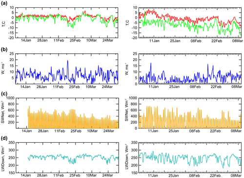
At the Larsemann Hills, the field campaigns were carried out during two summer periods of 2012–2013 and 2014, and the weather was different for these two seasons. The first season was, in general, colder and wetter compared to the climatology, and heavy cloudiness was observed more frequently (Table ). The duration of sunshine was half, and the total precipitation was double, that of the climatology. The summer of 2014 was dry and sunny, and the monthly meteorological variables were close to the multi-year means (Table ). During the campaign of 2014, the air temperature reached almost 10 °C in the first ten-day of January, then decreased to around 0 °C for two weeks in February, and finally dropped below zero in the last ten-day of February. The dew point was lower than the air temperature, which reflects dry conditions. Due to the sunny conditions, the downward longwave radiation flux varied greatly but was small in general: down to 180 W m−2 during frequent sunny cases and up to 280 W m−2 but only for rare cloudy cases (see Fig. ). The net shortwave radiation in January was large, with the day maximum values up to 750 W m−2, but it decreased quickly. At the beginning of March, the day maximum values dropped down to 450 W m−2 in sunny cases and 250 W m−2 in cloudy days.
4.2.2. Surface water temperature of the lakes
Most of the lakes at the Fildes peninsula are shallow and differ only in size. During the campaign of 2012, all the lakes were free of ice, and the LWST reached 13.5 °C (Lake Dlinnoe). The observed and modelled values of LWST as well as model errors are presented in Table . Note that, in Table , the observed mean LWST varies between lakes only by 2 °C, and the maximum LWST varies by 6.5 °C, apparently independently of the lake surface area. The evolution of the observed and simulated LWST for three lakes of different volumes (1,200, 24,800 and 93,800 m3) is shown in Fig. (left column). The evolution of the observed LWST is similar for all three lakes, with two maxima and one minimum in the second ten-day of February (due to the heavy snowstorm) in the background of the seasonal temperature decrease. Thus, we may suggest that the one-dimensional lake model should be capable of reproducing LWST. This was proved by the lake model FLake: the modelled LWST fit well to the observations (Fig. and Table ). The model bias was small in absolute value, up to 0.6 °C for Lake Kitezh. It was negative for some lakes and positive for others; thus, there was no systematic overestimation or underestimation of LWST. Maximum RMSE was 2.1 °C for Lake Dlinnoe. For all lakes, the model reproduced well the evolution of LWST due to both local weather variations and seasonal changes. However, for all lakes at this site, the simulated seasonal maximum LWST was systematically underestimated, and the temperature drops due to the weather conditions were too low. According to FLake, the amplitude of the diurnal cycle of LWST was less than 1.0 °C. Unfortunately, this amplitude is not known from the measurements. Thus, we suppose that FLake underestimated the diurnal cycle amplitude in our experiments. The reason for this smoothed behaviour of the simulated LWST might be associated with errors in forcing data.
Fig. 5. The evolution of LSWT during measurement campaigns of 2012 at the Fildes Peninsula (right column) and of 2014 at the Larsemann Hills: observed (blue dots) and modelled by FLake (red line).
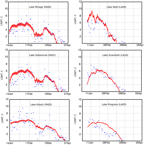
During the measurement campaigns in the Larsemann Hills, small lakes such as Lake Sarah Tarn were free of ice, but on large lakes, such as Lake Scandrett/Nella and Lake Progress, ice forms remained throughout the warm season, usually covering about 60–80% of the water surface. For the shallow Lake Stepped, the summer maximum LWST reached 10.5 °C in 2014 (Table ). According to Table , the observed mean LWST varies between lakes at this site by less than 2 °C, and the maximum LWST varies by only 3.3 °C. The shallow, very turbid and large Lake Stepped is the warmest, whereas the shallow, turbid and small Lake Reid is the coldest in terms of the maximum summer LWST. The large and deepest lake, Lake Progress, is the coldest in terms of the mean summer LWST. The evolution of the observed and simulated LWST for three large lakes of different mean depths (0.8, 6.6, 11.2 m) is shown in Fig. (right column). The evolution of the observed LWST is different: for the shallow Lake Reid, the variability of LWST is larger, while for the deep Lake Progress, LWST is generally lower. According to Fig. and Table , FLake reproduces LWST well with the maximum model bias of –1.6 °C for Lake Scandrett/Nella and the maximum RMSE of 3.1 °C for Lake Sarah Tarn. The model bias is both positive and negative; thus, it does not represent a systematic underestimation or overestimation of LWST. However, the timing of the LWST summer maximum is not reproduced well. For the deepest lake, Lake Progress, the simulated LWST is systematically higher than observed, although it decreases quickly and falls below zero up to eight days earlier than the observed dates. According to the temperature simulation by the FLake, the amplitude of the diurnal cycle in the LWST reaches only 0.5 °C, which is supposedly too low.
4.2.3. Freeze-up of the lakes
The observed freeze-up dates of the lakes at the Fildes peninsula varied by up to two weeks (see Table ): the smallest (Lake Mirage) was the first to become frozen at 21.03.2012, while the largest (Lake Kitezh) was the last at 05.04.2012. Note that all lakes of the Fildes peninsula are relatively transparent. Thus, for these climate conditions, two weeks is a natural variability for freeze-up dates, depending mainly on the surface area. FLake produced the same variability of 2 weeks between freeze-up dates, but depending strictly on the mean lake depth: the earliest simulated freeze-up date is 22.03.2012 for two very shallow lakes: Lake Mirage and Lake Srednee, while the latest simulated date is 04.04.2012 for two deeper lakes, Lake Kitezh and Lake Glubokoe. The absolute error of FLake in reproducing freeze-up dates is about 3–4 days, without giving it systematically earlier or later.
In the Larsemann Hills, the observed freeze-up dates varied among different lakes for only four days (see Table ): the earliest was 22.02.2014 for small and shallow Lake Sarah Tarn, while the latest was 26.02.2014 for large and deep Lake Progress. For this site, the strong meteorological forcing plays the dominant role in defining the freeze-up dates for lakes, almost independently of their depth, size and water transparency. There were strong snowstorms in the beginning of the second decade of February, which provoked the freezing of almost all lakes. FLake reproduced this situation well, without any systematic delay or getting ahead, and with an absolute error of approximately 2–3 days.
4.2.4. Thermal balance of the lakes
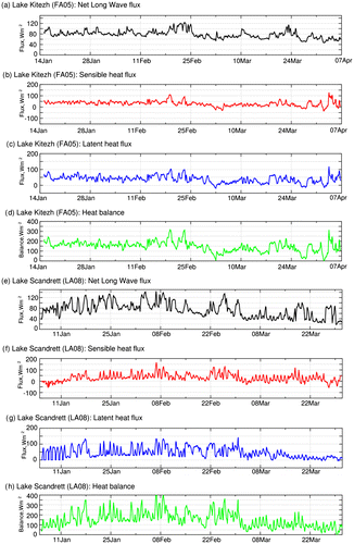
During the summer at the Fildes peninsula, the most shallow lakes usually stay mixed due to wind that blows frequently from the south and south-west, while for deeper lakes there exists temperature stratification of the water column (Orlov, Citation1973). However, according to simulations by FLake, all the lakes were mixed down to the bottom. An example is the large and relatively deep Lake Kitezh: Fig. shows the evolution of the mean water temperature, the bottom temperature and the mixed layer depth for this lake. During almost the whole summer, the mean water temperature and bottom temperature were equal to each other in the model run, and the mixed layer depth was equal to the lake depth. We suggest that the main mechanism for this was wind mixing, supported by absence of the lake water’s stable conditions. Stable conditions with the growing thermocline layer are typical for boreal lakes in summer. For Maritime Antarctic lakes in summer, we assumed that stable conditions are absent due to the weak heating of the water surface. Heating of the water surface may be estimated from the heat balance and the net shortwave radiation. Note that, in contrast to the land, the lake water is transparent to the shortwave radiation; thus, it is not meaningful to calculate a sum of the two. Components of the heat balance are the net longwave radiation, sensible heat flux and latent heat flux. Heat balance and its components for Lake Kitezh are presented in Fig. . In meteorological notation, the positive heat balance of the (lake) surface means that a lake releases heat into the atmosphere. This heat loss is approximately compensated for by the net shortwave radiation. For Maritime Antarctic lakes in summer, the low net shortwave radiation (Fig. ) compensates for the large positive heat balance of the lake surface; hence, heating of the lake surface is weak. For example, for Lake Kitezh during the first month of the campaign (16.01.2012–14.02.2012), the average heat balance was positive and large, with a value of 160 W m−2; hence, the mean net shortwave radiation, with a value of 210 W m−2, could provide only weak heating of the lake surface.
Fig. 6. The evolution during the periods of measurement campaigns of 2012 (the Fildes Peninsula) and 2014 (the Larsemann Hills) of the mean water temperature Tm (black line), bottom temperature Tb (green line) and mixed layer depth H (red line) as simulated by FLake for different lakes at these sites. See comments in the text.
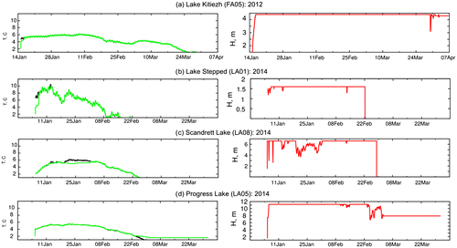
According to simulations by FLake, all the lakes at the Larsemann Hills were mixed down to the bottom. Three examples are given in Fig. : for the shallow Lake Stepped, for the medium-depth Lake Scandrett/Nella and for the deepest Lake Progress. According to Fig. , the mean water temperature is equal to the bottom temperature, while the mixed-layer depth is equal to the lake depth for almost the whole model run for all lakes. These results are partly supported by the measured temperature profiles for Lake Stepped for February 2013 (see Fig. ). All the measurements show an almost homogeneous profile. We suppose that the physical mechanisms of the mixing are different for deep and shallow lakes. For the deep glacial lakes, the main mechanism is convection, since the values of LSWT vary mostly around 4 °C (the temperature of maximum water density; see Fig. d for Lake Progress). For shallow lakes, the main mechanism is wind forcing (similar to the Fildes peninsula; see Fig. b for Lake Stepped). Note that katabatic flows regularly occur in the Larsemann Hills in the mornings and evenings. Sometimes, for the deeper lakes under calm conditions with a wind speed of less than 4 m s−1, a lake may be slightly stratified (see Fig. c for Lake Scandrett/Nella as an example). Wind mixing may or may not be supported by the lake water stability conditions. Similar to Maritime Antarctic lakes, for coastal Antarctic lakes we assume that stable conditions are predominantly absent due to weak heating of the water surface in the summer (see the discussion for the Fildes peninsula). Heat balance and its components for Lake Scandrett/Nella are presented in Fig. . In summer, until the end of February, the heat balance for this lake varied greatly but in general was positive and large. For the first month of the campaign (06.01.2014–04.02.2014), the average value of the heat balance was 170 W m−2, and the mean net shortwave radiation was 200 W m−2. This could provide only a weak heating of the lake surface.
Fig. 7. The temperature profiles at different moments in time for Lake Stepped (LA01) for 2013: February, 5 (red line), February, 10 (green line), February, 23 (blue line).
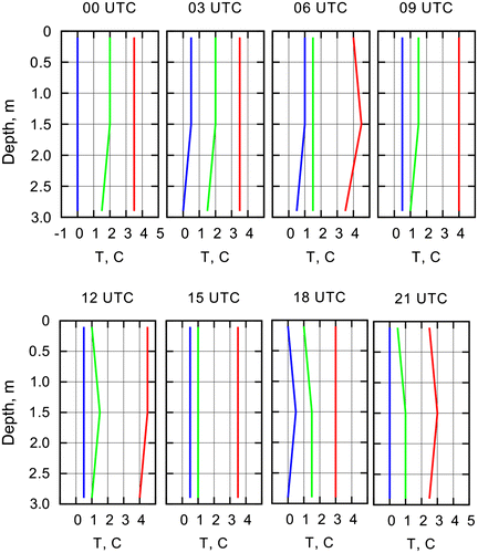
Fig. 8. The evolution of the lake water surface heat balance and its components, (W m−2), calculated by FLake, for Lake Kitezh (FA05) at the Fildes Peninsula for the period of the measurement campaign of 2012 and for Lake Scandrett/Nella (LA10) at the Larsemann Hills for the period of the measurement campaign of 2014: (a, e) net longwave radiation; (b, f) sensible heat flux; (c, g) latent heat flux; (d, h) heat balance. Here, all fluxes are positive upward, from the lake to the atmosphere.
4.2.5. Summary of the FLake experiments
In general, in our Antarctic experiments, the FLake reproduced LWST and freeze-up dates well, with errors smaller than those reported in the publications for boreal lakes and warm lakes (Kourzeneva et al., Citation2012; Choulga and Kourzeneva, Citation2014; Kourzeneva, Citation2014; Thiery et al., Citation2014). One reason for this is the tuning of the light extinction coefficients, which is not possible in massive experiments. Another reason is the dominant mixing regime of the lakes. The lakes were mixed, and this regime is easier for simulation than the stratified regime. We assume different mechanisms of mixing for shallow and deep lakes. For shallow lakes, the mechanism was wind mixing on the background of weak surface heating due to small net shortwave radiation and large positive heat balance for both sites. For deep lakes (located at the Larsemann Hills), the main mechanism behind mixing was convection: the lake water temperature was close to the maximum water density temperature, which caused frequent convection and mixing. The persistent stratification in the shallow lakes of the Larsemann Hills due to meromixis is described by Kaup and Burgess (Citation2003). In the future, the hypothesis about the summer mixing regime of Antarctic and Maritime Antarctic lakes and different reasons for it should be verified against temperature profile measurements.
The heat and water balances of lakes are connected through the latent heat flux and evaporation term. For a model of lake thermal regime, the evaporation is a by-product: it is calculated to estimate the latent heat flux. If a lake model is incorporated into an NWP or climate model, the amount of evaporation is a source term in the moisture transfer calculations in the atmospheric part of the model. In hydrological applications, the evaporation is calculated by empirical methods (using the observed LWST) as a component of the water balance. We compared two estimations of the daily evaporation: (i) from the atmospheric surface layer block of the lake model FLake, and (ii) from Equation (Equation2(2) ). This empirical method is crude, but it uses the real measurements. In our estimations, the LWST daily measurements were used. Since the LWST measurements were usually performed mid-day, we can expect that the evaporation would be over-estimated, because the daytime LWST is higher than the daily average. The atmospheric surface-layer block of FLake uses physical methods, but with simulated LWST values. FLake provides the evaporation flux with the temporal resolution of the experiments (of several minutes). In this case, provided that the simulated LWST diurnal cycle is less than the observed LWST diurnal cycle, and the model bias (which is small) is estimated from the mid-day measurements, we can suppose that the daily evaporation may be under-estimated by FLake’s surface-layer block. However, both the total seasonal and mean daily amounts of evaporation calculated by FLake’s surface-layer block are 20–40% larger than estimated by the empirical equation (Table ). Thus, we presume that using FLake increases the accuracy of the evaporation calculations; however, this should be proved by the flux measurements. Thus, there is potential for using FLake in hydrological applications to estimate evaporation, especially for cases in which the evaporation is a significant term of the water balance.
Table 6. Seasonal and daily evaporation from the lake water surface for the period of measurements, from the atmospheric surface layer block by FLake and estimated by the empirical equation of Odrova (Citation1978).
4.3. Water balance of lakes
We estimate here the terms of the water balance equation (see Equation (Equation1(1) ) in Section 3). The lake water volume change (dV) term was evaluated using the water level measurements. In the summer, the changes in the water levels of the lakes are smooth and are usually caused by the weather conditions, especially changes in the air temperature and cloudiness, which usually trigger the snow melt (McConchie and Hawke, Citation2002; Vihma, Citation2011). The maximum increase of the water levels was observed in the small endorheic lakes (Lake Mirage, Lake Sara Tarn). For the medium-sized lakes, the water level increased during the first few weeks of the warm season due to the income of snow melt over the watershed. The water levels then decreased due to releasing water through the surface/sub-surface outflow and evaporation. The water levels of the big and deep lakes with outflow varied weakly during the summer. The only exception was the system of lakes Progress–Sibthorpe, which shows an abrupt release of the water due to the break of the snow dams separating the lakes. The water levels of these lakes dropped by up to 1.0 m within both the 2013 and 2014 seasons.
The term (P), which refers to the precipitation over the lake water surface, was estimated using three-hour observations. On the Fildes peninsula, the precipitation was 160 mm for the period of January–March 2012; it fell mostly in liquid phase, while only within the period of 17.02.–18.02.2012 did the precipitation fall as snow. Precipitation at the Larsemann Hills is rare and usually falls as snow. During the field campaign of 2013, the total precipitation for the observation period was 24.4 mm, which is double the amount for the campaign of 2014 (12.8 mm), despite the fact that the duration of the 2014 campaign was three times longer than that of 2013. In this region, the precipitated snow accumulates in the local depressions and forms a multi-year snowpack.
The terms (Yin, Yout), which refer to the surface water inflow/outflow for the lakes, were evaluated using the observations from the discharge gauges (Table ). The observations from the gauges FA31 and LA07 represent the surface runoff from the watershed not connected with the lakes, and outflow is formed by melting snow cover and soil thawing. The peak discharges on all streams were usually associated with the increase of the air temperature by 1.0–1.5 °C per day and/or the rainfall. The daily discharges were higher in the outlet streams, since the runoff was supported by the lakes’ water capacity, while the discharges in the inlets depend on the weather conditions. The discharges’ maximums were slightly pronounced on the outlet creeks (Fig. ), since the lakes usually smooth the runoff peaks and increase the low flow in the outlet streams. The day-by-day fluctuations of river streamflow were expressed by the coefficients of variation (CV), which is defined as the ratio of the standard deviation to the mean value calculated from the daily discharge time series. The CV values of the daily discharges for the outlets were lower than for the inlets, with the highest values of 1.12–1.83 at the gauges for the Fildes peninsula and the Larsemann Hills sites (Table ). These gauges are located on the creeks with the catchments without small ponds, which may retain the surface flow.
Fig. 9. The precipitation and water discharges measured by appropriate gauges at the rivulets on the Fildes Peninsula (left column) and the Larsemann Hills (right column).
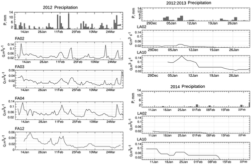
Table 7. Level variability and surface runoff characteristics during the periods of observations.
Other terms of the water balance equation are the subsurface inflow Gin, which is formed by percolated water from snow melt and rainfall, and the subsurface outflow Gout. Also for the lakes, which are used for the water supply for human needs, the volume of water withdrawal (W) was included in the water balance. In this study, we do not consider the subsurface inflow/outflow terms, and we put these components to the discrepancy in the water balance. The discrepancy in the water balance equation D is the sum of terms that were not estimated from the direct measurements. Depending on the lake, the discrepancy includes the subsurface inflow and outflow (Gin and Gout), evaporation E, and an amount of water supply (W). Table summarizes the seasonal estimates of the water balance terms and the discrepancy.
Table 8. Water balance components of the studied lakes in the Antarctic.
4.3.1. Water level and volume
The observational period at the Fildes peninsula started in the first decade of January 2012, about six weeks after the beginning of the warm period, and thus the spring peak flow had mostly passed. The snow cover melted out over most of the watersheds, and it was presented only at altitudes higher than 80 m above sea level or on the local depressions. During the field campaign, the water level gradually increased on the small endorheic lakes. Lake Mirage accumulated water total 4.5% of its volume up to the beginning of April. In the lake system Slalomnoe–Srednee–Kitezh, the water level slightly increased during the first week of the field campaign, then continuously decreased until the lake was frozen at the end of March. The maximum absolute water level change in the system was observed for Lake Srednee, which collects the water from the upper part of the watershed and releases it to Lake Kitezh. The water level of Lake Dlinnoe decreased continuously until the end of March. The largest recession of the water level (over 0.50 m or 9% of the total water volume) was observed for Lake Glubokoe. The catchment of this lake is relatively small (Table ), and the melting of the rest of the snow pack remaining on the catchment up to the beginning the observation period did not provide enough income of water to feed the lake. The water level decrease was additionally enhanced by the subsurface leakage through the eastern side of the lake and the extraction of water to provide the water supply of the Artigas base (Uruguay).
Both measurement campaigns at the Larsemann Hills started in the middle of the summer season and covered the period of the gradual decrease in the surface flow. However, on small endorheic Lake Sarah Tarn, the water level continuously increased (Fig. ), and the lake accumulated more than 13% of the total water volume during both seasons, despite the fact that the observational period was three times longer in 2014 than in 2013. The lake was mostly fed by snow melt, which took place during first few weeks of the warm season (usually until the end of January). Thereafter, the lake level increased slowly (Fig. ). The water levels of Lake Reid and Lake Scandrett/Nella increased continuously during the first one–two weeks of both campaigns due to the warm and sunny weather conditions. Thereafter, the levels decreased (see, in Fig. , the example for Lake Reid for the campaign of 2013).
Fig. 10. The level changes on the lakes of different sizes at the Larsemann Hills. The image on the right is extracted from the orthomap with the scale 1:4000 (State Bureau, Citation2006).
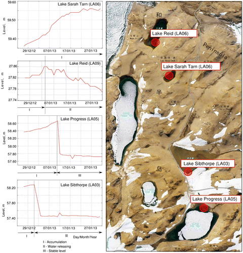
The lake system Progress–Sibthorpe demonstrated the abrupt changes in the water level that were triggered by the melting of the snow dams separating the lakes in the system. Two abrupt level jumps were observed during the field campaign of 2013: on January 1st, the snow dam blocking the outlet creek (LA04) melted out, and the water level of Lake Sibthorpe dropped by 0.86 m in one night. Ten days later, the water level of Lake Sibthorpe swiftly increased by 0.30 m due to the breaking of the snow dam between this lake and the higher Lake Progress, increasing the water inflow from it. At the same time, the water level of Lake Progress decreased by 1.0 m (Fig. ). During the field campaign of 2014, the snow dam between the lakes melted out by January 21st, and the water level of Lake Progress then decreased by 0.70 m (not shown). These jumps caused the largest changes in the water volume due to massive water escapes into the sea lasting several hours.
Lake Stepped is located close to the sea coast on the flat marine terrace, and its water level was nearly stable during both the 2013 and 2014 seasons. The water income for this lake was provided by the melting of the multi-year snowpack, which occupies the south-east corner of the watershed. The water outcome includes the surface inflow through the creek with gauge LA02 (Table ), subsurface outflow, evaporation and the water withdrawal for the Progress-II base (Russia). The water level of Lake Stepped did not change essentially even in the case of breaking of the artificial dam, which separates about 30% of the catchment and allows melting water to be retained in the small reservoir (Fig. (b)). This reservoir is used as additional volume to supply Zhongshan base (China). After the dam breaking, the water from this reservoir passed into the sea within several hours through the outlet (LA02).
4.3.2. Surface inflow and outflow
In the Fields peninsula, the discharge measurements covered 12 weeks of the runoff recession phase until the first decade of April, when the daily air temperatures fell below zero and the surface flow decreased substantially or stopped. The prominent flow peaks observed at all streams during February 10–12 and 18–19 and March 3–4 and 28–29 (Fig. ) were caused by the rainfall, which also amplified snow melt. These peaks were better pronounced in the hydrographs of the inlets (see FA03 in Fig. ); however, they were also notable for the gauges located on the outlets, where the flow hydrographs were smoothed due to the regulation of lakes. The time delay between the rainfall and discharge peaks was about 1–3 days even for the outlets. The amplitude of the flow peaks was determined by the snow cover fraction of the catchment, rather than only by the intensity of the rainfall. During February, the variation in the daily discharges for the inlets/outlets for Lake Kitezh was higher than for Lake Dlinnoe, while the intermittent snow cover was still present on the watershed of Lake Kitezh but not Lake Dlinnoe. The specific water discharges in the streams were calculated as daily discharge divided to the watershed area, and the values varied over the territory from 0.008 to 0.081 m3 s−1 km−2 (Table ).
For Lake Mirage, the discrepancy in the water balance was 1.0% of the total lake volume. According to Table , the increase in the lake volume is approximately equal to the residual precipitation and evaporation over the lake’s open water surface. Thus, the inflow due to snow cover melting should be very low according to the discrepancy of the water balance. However, the extent and depth of the multi-year snowpack on the catchment decreased more than twice during the period of the field campaign (the data from snow cover measurements are not analysed in this study); hence, the increase in the lake volume due to snow melt is expected to be more notable. Thus, it is possible that the subsurface outflow through the south-east side of the lake exists and is reimbursed by the inflow due to snow melt.
The water balance of the lake system Slalomnoe–Srednee–Kitezh corresponds to the lowest lake in the system, Lake Kitezh. Two inlets collect the water from 30% of the total catchment area (the remaining 70% of the catchment provides only the subsurface inflow), but they bring a volume of water with a magnitude of one order larger than the precipitation over the lake (Table ). The gauge FA04 was established downstream from the pumping station; thus, these measurements represent the outflow from Lake Kitezh plus the water withdrawal. The water volume, which was extracted for the needs of Bellingshausen base, was supposedly 10.0 m3 per week (according to R. Eliseev, personal communication). The discrepancy in the water balance of Lake Kitezh is positive, with an amount of 3.2% of the total lake volume, and it includes the subsurface inflow/outflow and water withdrawal to supply human needs.
During the warm period at the Larsemann Hills, the melted water from the snow deposits in the local depressions usually feeds the surface streams and percolates into the soil to form subsurface flow. On the flat and open sectors of the landscape, the snow cover is very thin and usually melts out during the first one to two weeks of the warm season due to high income of solar radiation. Water from snow melt comes to the lakes through the net of small surface creeks (preventing the establishment of a gauging site) or as the subsurface inflow (the estimates are not presented in this study). In the outlet streams (LA02, LA04, LA10), the daily water discharges slightly decreased over the period of observation, and the coefficients of variation were 0.50–0.60 (Table ). The small peaks of water discharge were observed at all gauges in the first ten-day of January 2013 (Fig. ) due to the wet snowfall. The specific water discharges were of 0.045–0.069 m3 s−1 km−2, and they did not vary much over the streams in the region (Table ).
4.3.3. Water balance discrepancies
In the Fildes peninsula, the largest water balance discrepancy is observed for Lake Dlinnoe (FA11); it is positive and equals approximately 200% of the total lake volume (Table ). The surface outflow (measured at the gauge FA12) is very high compared to other water balance components (Table ). The water income/outcome due to the rainfall and evaporation are the minor components in the water balance, since the lake surface area is relatively small. The catchment of Lake Dlinnoe is V-shaped, and there are no local depressions retaining water from snow melt. Thus, we can suppose that the surface flow on gauge FA12 indicates the inflow supported by the snow cover melt and partly accumulated underground. The income from snow melt was calculated as the discrepancy in the water balance divided by the watershed area and expressed in mm. It appeared to be 1.7 mm day−1 on average for the period of observation, in agreement with the preliminary results supported by the measurements of snow cover properties (not included in this study).
According to Table , the discrepancy in the water balance for Lake Glubokoe is negative and twice the amount of the changes in the water volume (16% of the total lake volume). It includes two main components: water leakage through the lake side and water withdrawal to supply the Artigas base, which were not measured during the campaign of 2012.
In the Larsemann Hills, the discrepancy of the water balance of Lake Stepped (LA01) is positive and takes an amount of 50% of the total volume of water for both seasons (Table ). This amount includes the inflow due to snow melt (the biggest part of the water income) and two negative components: (i) subsurface outflow (which could be substantial since the catchment of the lake mostly consists of sand and gravel) and (ii) water withdrawal for the technical needs of the Progress-II base (Russia). Lake Stepped is one of the warmest in the region; thus, the evaporation was 3–4 times larger than the precipitation over the lake’s open surface (see the 2014 season in Table ). The lowest discrepancy in the water balance was obtained for Lake Sarah Tarn and Lake Reid. Both lakes are relatively small, and snow cover over their catchment area usually melts out during the first three to four weeks of the warm season. Then, the precipitation does not provide sufficient water income to supply the lakes, and their level increases slowly (see Fig. , Lake Sarah Tarn) or even decreases (see Fig. , Lake Reid). For Lake Reid, the decrease of the level may corresponds to the subsurface outflow through the north-west side of the lake. The evaporation over the open surface of the lake is 4–5 times greater than the precipitation. Among the lakes at the Larsemann Hills, the largest discrepancy in the water balance was evaluated for Lake Scandrett/Nella. This lake is fed not only by snow melting but also from the Dålk glacier (an inlet creek exists on the southern corner of the lake), and the income from these two water sources is approximately equal. The lake releases the water surplus through only one outlet (gauge LA10). The change of the lake water volume was about 1% of its total capacity. The amount of evaporation in 2014 was double that of the change in the total volume.
The sensitivity of the water balance analysis to the method of calculating the evaporation, following Odrova (Citation1978) or using FLake, can be estimated from Table . The terms of the water balance equation (Equation (Equation1(1) ) in Section 3.1) may have different orders of magnitude. From our observations, we distinguished two situations in relation to the surface flow terms (Yin, Yout): (i) when they equal to zero or their difference is comparable with the other terms of the water balance equation, and (ii) when they are very different and much larger than the other terms. In case (ii), the evaporation term E is small compared to the main terms (Yin, Yout), and the method used to calculate E is not important. This is the case for Lake Dlinnoe, Lake Stepped and Lake Progress. In case (i), the evaporation term E is comparable with other terms, and the method for calculating it may be important. To evaluate its relative impact, we used the difference between the evaporation calculated by two methods (EFLake – E) normalized by the volume change dV (the percentage value). This value appeared to be large: 33% for Lake Mirage, 18% for Lake Kitezh, 15% for Lake Sarah Tarn and 47% for Lake Reid. The exception is Lake Glubokoe, because for this lake two methods of calculating evaporation give the same value. Most of the lakes, for which the impact appeared to be high, are endorheic. Lake Kitezh is not endorheic, but for this lake the difference between Yin and Yout terms has the same order of magnitude as the other terms of the water balance equation. Thus, we suggest that the accuracy of the method to calculate evaporation from the lake surface may be important for endorheic lakes or for situations in which the difference between Yin and Yout is comparable to other terms of the water balance equation. In these cases, increasing the accuracy of the evaporation calculation may reduce the discrepancy D substantially. With these calculations, we confirm the potential of FLake for use in hydrological applications; however to reach final conclusions, direct evaporation measurements are needed.
5. Conclusion
In the Antarctic, there are many small and medium-sized lakes located in coastal oases and on Maritime Antarctic islands, including in inhabited areas. We studied thermal regime and water balance components of 12 lakes located in two different parts of the Antarctic – the Fildes peninsula in the Maritime Antarctic and the Larsemann Hills in the continental Antarctica – with observations from three field campaigns carried out in 2012–2014. During these campaigns, the morphometric characteristics of the studied lakes were updated with GPS/echo-sounding surveys. The length/width, area and volume of the lakes estimated from the new surveys differ from those of historical surveys, especially for the lakes at the Fildes peninsula, where the previous surveys were performed in the early 1970s. We suppose that these differences in morphometric characteristics reflect the dynamics of the coastal processes, which are intensive in the Maritime Antarctic.
According to the observations, all of the small lakes at both sites were free of ice during the summer measurement campaigns. In the Maritime Antarctic (i.e. the Fildes peninsula), the lakes became frozen between the end of March and the beginning of April, and the freeze-up dates varied by up to two weeks between different lakes depending on their depth and surface area. In the continental Antarctica (the Larsemann Hills), the lakes were frozen by the end of February, and the variability in freezing between different lakes was much less – only four days. This means that the atmospheric forcing is much stronger in the continental Antarctica. The seasonal maximum LWST was also 3.5 °C higher for the lakes in the Maritime Antarctic than in the continental Antarctica.
The thermal regime of lakes was also studied by modelling, applying the lake model FLake. FLake, which is used to represent lakes in many NWP and climate models (including global ones), was seriously tested for the Antarctic region for the first time in this study. FLake, being driven by meteorological observations, is able to reproduce well the evolution of LWST of the Antarctic lakes, with the largest model bias of 0.6 °C and RMSE of 2.1 °C for the lakes in the Maritime Antarctic; for the lakes in the continental Antarctica, these values are 1.0 and 3.1 °C, respectively. The freeze-up dates are also reproduced well, differing from the observed ones by 2–4 days. However, the modelling results appeared to be sensitive to the light extinction coefficients. This finding differs from that of lakes in the boreal zone; for them, the sensitivity of the modelling results by FLake to the water extinction coefficient is much less pronounced (Kourzeneva and Braslavsky, Citation2005). According to FLake simulations, all lakes in the Maritime Antarctic and the continental Antarctica, both deep and shallow, were mixed down to the bottom for the whole summer. We suggest that the reasons for this are different for shallow and deep lakes. For deep lakes, the main mechanism is convection; the lake water temperature remains close to the maximum water density temperature. For shallow lakes, the main mechanism is wind mixing, supported by weak heating of the water surface. Convection is also may be influential in shallow lakes. However, their LWST (both from the measurements and modelling results) is higher comparing to the LWST of deep lakes and differ more from the maximum density water temperature. This means the Antarctic shallow lakes (in comparison with deep lakes) tend to be similar to boreal lakes which have stable conditions in summer. But due to the wind stress, the shallow lakes in the Antarctic are mixed. However, this hypothesis should be verified by measurements.
The amount of evaporation calculated by the atmospheric surface layer block of FLake is 20–40% larger than the values found by Odrova (Citation1978). We presume that the accuracy of calculations by FLake is higher; however, this should be further proved by observations of evaporation.
The seasonal changes of the lake levels were expressed better at the Larsemann Hills in the continental Antarctica than at the Fildes peninsula in the Maritime Antarctic. Usually, small and medium-sized lakes accumulate or redistribute snow melt water during the warm season. However, the systems of lakes in the Antarctic oases also release their water storage through the mechanism of abrupt jumps, which simultaneously cause the inflow into the sea of huge amounts of fresh water over short time intervals. It was found that, at the Larsemann Hills, lakes regulate the seasonal freshwater inflow into the sea by three main mechanisms: accumulation, smooth redistribution and abrupt releasing. The same three mechanisms of regulating seasonal water storage were found for the lake systems at the Schirmacher Oasis (I. Fedorova, personal communication). We suggest that these three mechanisms are common for the Antarctic oases.
Small endorheic ponds at the Fildes peninsula and the Larsemann Hills (e.g. Lake Mirage and Lake Sarah Tarn) typically continuously accumulate water during the warm season, and the snow melt/rainfall inflow exceeds the evaporation. For endorheic lakes, and for lakes with a small difference between the surface water inflow and outflow, it was found that the method of calculating evaporation may be substantial in assessing the water balance discrepancy. For the studied lakes, the maximum difference between the amounts of evaporation calculated by FLake and following Odrova (Citation1978), reached 47% of the seasonal volume change. Thus, we see the potential of using FLake for hydrological applications to evaluate evaporation. Evaporation and water balance estimated by FLake might be sensitive to the light extinction coefficient, and this aspect should be studied further.
Studies of Antarctic lakes may be useful to estimate the seasonal freshwater income to the sea due to snow melt, which can be roughly estimated from the water balance of mid-sized lakes with a single outflow stream releasing the water surplus, and with the watershed without local depressions, which usually retain the water. Another option issue is to establish the level gauge on a small endorheic lake to evaluate the specific volume of freshwater inflow (in mm km−2) in seasonal scale. Measurements of snow cover properties are also needed.
To better study the three types of regulation for lakes of different sizes in Antarctic oases, a hydrological model should be proposed and validated against observations. Special observations of underground flows and snow are needed to evaluate the rest of the water balance terms of Antarctic lakes. Measurements of evaporation from the lakes’ open-water surface will make it possible to reach a final conclusion about the accuracy of different methods to calculate it. All of the aforementioned work will make it possible to describe a seasonal variability of the freshwater inflow into the sea in the Antarctic region.
Disclosure statement
No potential conflict of interest was reported by the authors.
Funding
The study was funded from the Russian Federation Program ‘Study and Investigation of Antarctica’ and the Academy of Finland AMICO project [contract number 263918].
Acknowledgements
We are grateful to the Russian Antarctic Expedition in supporting the field works. Our special thanks to L. Lesnichy, M. Naumov, A. Zubov, A. Krasnov and K. Vershinin for the field work participation, and to R. Kuznetsov who helps much in testing of the equipment. Two anonymous reviewers made many useful comments.
Related Research Data
References
- AAD: Australian Antarctic Division. 2005. Broknes Peninsula. Larsermann Hills. Princess Elizabeth Land. Antarctica. Environmental management map at scale 1:10000.
- Barriga, R., Montero, J., Villanueva, V., Klotz, J. and Bevis, M. 2001. Geodesy and digital cartographic survey in Fildes Peninsula, Rey Jorge Island, Antarctica. Geo-spatial Inf. Sci. 4(2), 25–31. DOI: 10.1007/BF02826974.
- Bintanja, R., van Oldenborgh, G. J. and Katsman, C. A. 2015. The effect of increased fresh water from Antarctic ice shelves on future trends in Antarctic sea ice. Ann Glaciol. 56(69), 120–126. DOI: 10.3189/2015AoG69A001.
- Bromwich, D. H., Nicolas, J. P. and Monaghan, A. J. 2011. An assessment of precipitation changes over Antarctica and the Southern Ocean since 1989 in contemporary global reanalyses. J. Clim. 24, 4189–4209. DOI: 10.1175/2011JCLI4074.1.
- Burgess, J. C. and Kaup, E. 1997. Some aspects of human impact on lakes in the Larsemann Hills, Princess Elizabeth Land, Eastern Antarctica. In: Ecosystem Processes in Antarctic Ice-Free Landscapes (eds. W.B. Lyons, C. Howard-Williams and D. Hawesi). Balkema, Rotterdam, pp. 259–264.
- Bydder, E. L. and Holdsworth, R. 1977. Lake Vanda (Antarctica) revisited. New Zeal J Geol Geop. 20(6), 1027–1032. DOI: 10.1080/00288306.1977.10420695.
- Chikovani, S. M. 1971. Equipment offered by the ‘Gidrometpribor’ plant. Meas. Tech+. 14(3), 509–509.10.1007/BF00980314
- Chinn, T. J. 1993. Physical hydrology of the Dry Valley lakes. In: Physical and Biogeochemical Processes in Antarctic Lakes (eds. W. J. Green and E. I. Friedmann). American Geophysical Union, Washington, DC, pp. 1–51. DOI: 10.1029/AR059p0001.
- Choulga, M. and Kourzeneva, E. 2014. Verification of indirect estimates for the lake depth database for the purpose of numerical weather prediction and climate modeling. Proc. Russ. State Hydrometeorol. Univ. Theor. Res. J. 37, 120–142 (in Russian).
- Dominguez, M. C. and Eraso, A. 2007. Substantial changes happened during the last years in the icecap of King George, Insular Antarctica. In: Karst and Cryokarst, Studies of the Faculty of Earth Sciences (eds. A. Tyk and K. Stefaniak). University of Silesia, Katowice, pp. 87–110.
- Doran, P. T., McKnight, D. M., Jaros, C., Fountain, A. G., Nylen, T. H., and co-authors. 2008. Hydrologic response to extreme warm and cold summers in the McMurdo Dry Valleys, East Antarctica. Antarct. Sci. 20(5), 499–509. DOI: 10.1017/S0954102008001272.
- Dutra, E., Stepanenko, V. M., Balsamo, G., Viterbo, P. and Miranda, P. M. A. 2010. An offline study of the impact of lakes on the performance of the ECMWF surface scheme. Boreal Environ. Res. 15, 100–112.
- Eerola, K., Rontu, L., Kourzeneva, E. and Shcherbak, E. 2010. A study on effects of lake temperature and ice cover in HIRLAM. Boreal Environ. Res. 15, 130–142.
- Ellis-Evans, J. C., Laybourn-Parry, J., Bayliss, P. R. and Perriss, S. J. 1997. Human impact on an oligotrophic lake in the Larsemann Hills. In: Antarctic Communities: Species, Structure and Survivaline (eds. B. Battaglia, J. Valencia and D.W.H. Walton). Cambridge University Press, Cambridge, pp. 396–404.
- Ferron, F. A., Simones, J. C., Aquino, F. E. and Setzer, A. W. 2004. Air temperature time series for King George Island, Antarctica. Pesquisa Antártica Brasileira (Braz. Antarct. Res.) 4, 155–169.
- Finch, J. W. and Hall, R. L. 2005. Evaporation from Lakes. Encyclopedia of Hydrological Sciences, Part 4 Hydrometeorology Centre for Ecology and Hydrology, Wallingford. pp. 635–646.
- Gillieson, D., Burgess, J., Spate, A. and Cochrane, A. 1990. An atlas of the lakes of the Larsemann Hills, Princess Elizabeth Land, Antarctica. ANARE Res. Notes 74, 1–175.
- Girdiuk, G. V. and Kirillova, T. V. 1974. Methodology to calculate the terms of radiation balance over the ocean. Meteor. Gidrol. 12, 63–69. (in Russian).
- Golosov, S., Terzhevik, A., Zverev, I., Kirillin, G. and Engelhardt, C. 2012. Climate change impact on thermal oxygen regime of shallow lakes. Tellus A 64, 17264. DOI: 10.3402/tellusa.v64i0.17264.
- Gorodetskaya, I. V., Kneifel, S., Maahn, M., Thiery, W., Schween, J. H., and co-authors. 2015. Cloud and precipitation properties from ground-based remote-sensing instruments in East Antarctica. Cryosphere 9, 285–304. DOI: 10.5194/tc-9-285-2015.
- Guidelines for hydrometeorological stations: Part 1. 1978. Gidrometizdat, Leningrad, 384 pp. ( in Russian).
- IGM/Instituto Geographico Militar de Chile and INACH/Instituto Antarctico Chileno. 1996. Isla Rey Jorge – Peninsula Fildes. Map at scale 1:10000.
- Izaguirre, I., Mataloni, G., Allende, L. and Vinocur, A. 2001. Summer fluctuations of microbial planktonic communities in a eutrophic lake – Cierva Point. Antarctica 23(10), 1095–1109. DOI: 10.1093/plankt/23.10.1095.
- Jenkins, A., Hellmer, H. and Holland, D. M. 2001. The role of meltwater advection in the formulation of conservative boundary conditions at an Ice–Ocean interface. J. Phys. Oceanogr. 31(1), 285–296. DOI: 10013/epic.12131.
- Kaup, E., Ellis-Evans, J. C. and Burgess, J. S. 2001. Increased phosphorus levels in the surface waters of Broknes, Larsemann Hills, Antarctica. Verh. Int. Ver. Limnol. 27(5), 3137–3140.
- Kaup, E. and Burgess, J. S. 2002. Surface and subsurface flows of nutrients in natural and human impacted lake catchments on Broknes, Larsemann Hills, Antarctica. Antarct. Sci. 14, 343–352. DOI: 10.1017/S0954102002000123.
- Kaup, E. and Burgess, J. S. 2003. Natural and human impacted stratification in the shallow lakes of the Larsemann Hills, Antarctica. In: Antarctic Biology in a Global Context (eds. A. H. L. Huiskes, W. W. C. Gieskes, J. Rozema, R. M. L. Schorno, S. M. van der Vies, and W. J. Wolff). Amsterdam, pp. 313–317.
- Kohler, M. A. 1954. Lake and pan evaporation. In: Water-Loss Investigations: Lake Hefner Studies, Technical Report. Geological Survey Professional Paper, Washington, DC, pp. 127–148.
- Kourzeneva, E. and Braslavsky, D. 2005. Lake model FLake, coupling with atmospheric model: first steps. In: Fourth SRNWP/HIRLAM Workshop on Surface Processes and Assimilation of Surface Variables jointly with HIRLAM Workshop on Turbulence (eds. P. Unde`n). Workshop Report, SMHI, Norrkoping, pp. 43–53.
- Kourzeneva, E., Martin, E., Batrak, Y. and Moigne, P. Le 2012. Climate data for parameterisation of lakes in Numerical Weather Prediction models. Tellus A 64, 17226. DOI: 10.3402/tellusa.v64i0.17226.
- Kourzeneva, E. 2014. Assimilation of lake water surface temperature observations using an extended Kalman filter. Tellus A 66, 21510. DOI: 10.3402/tellusa.v66.21510.
- Laybourn-Parry, J., Marchant, H. J. and Brown, P. E. 1992. Seasonal cycle of microbial plankton in Crooked Lake. Polar Biol. 12, 411–416. DOI: 10.1007/BF00243112.12,411-416.
- Laybourn-Parry, J. and Wadham, J. L. 2014. Antarctic Lakes. OUP, Oxford, pp. 1–40.10.1093/acprof:oso/9780199670499.001.0001
- Liston, G. E. and Winther, J.-G. 2005. Antarctic Surface and Subsurface Snow and Ice Melt Fluxes. J. Clim. 18, 1469–1481. DOI: 10.1175/JCLI3344.1.
- Martynov, A., Sushama, L., Laprise, R., Winger, K. and Dugas, B. 2012. Interactive lakes in the Canadian Regional Climate Model, version 5: the role of lakes in the regional climate of North America. Tellus A. 64, 16226. DOI: 10.3402/tellusa.v64i0.16226.
- Mataloni, G., Tesolín, G. and Tell, G. 1998. Characterization of a small eutrophic Antarctic lake (Otero Lake, Cierva Point) on the basis of algal assemblages and water chemistry. Polar Biol. 19, 107–114. DOI: 10.1007/s003000050221.
- McConchie, J. A. and Hawke, R. M. 2002. Controls on streamflow generation in a meltwater stream, Miers Valley, Antartica and implications for the debate on global warming. J. Hydrol. (New Zealand). 41(2), 77–103.
- Mergelov, N. S. 2014. Soils of wet valleys in the Larsemann Hills and Vestfold Hills oases (Princess Elizabeth Land, East Antarctica). Eurasian Soil Sci+. 47(9), 845–862. DOI: 10.1134/S1064229314090099.
- Michel, R. F. M., Schaefer, C. E. G. R., López-Martínez, J., Simas, F. N. B., Haus, N. W., Serrano, E., and Bockheim, J. 2014. Soils and landforms from Fildes Peninsula and Ardley Island, Maritime Antarctica. Geomorphology 225, 76–86.10.1016/j.geomorph.2014.03.041
- Mironov, D., Golosov, S., Heise, E., Kourzeneva, E., Ritter, B., Scheider, N., and Terzhevik, A. 2005. FLake – a lake model for environmental applications. In: Proceedings of the 9th Workshop on Physical Processes in Natural Waters (eds. A. Folkard and I. Jones). Lancaster University, Lancaster, 73 pp.
- Mironov, D., Heise, E., Kourzeneva, E., Ritter, B., Schneider, N., and Terzhevik, A. 2010. Implementation of the lake parameterisation scheme FLake into the numerical weather prediction model COSMO. Boreal Environ. Res. 15, 218–230.
- North-West Aero-geodesic Corporation of USSR. 1986. 1-IV-90-6, 3-VI-90-6. Maps at scale 1:2000.
- Odrova, T. V. 1978. Hydrophysics of Land Water Bodies Hydrometeizdat, Leningrad, pp. 1–312. (in Russian).
- Orlov, A. I. 1973. Geographical investigations on the Fildes peninsula. Trudy Sovetskoj Antarkticheskoj expeditsii 58, 184–207. (in Russian).
- Pienitz, R., Douglas, M. S. V. and Smol, J. P. 2004. Long-term Environmental Change in Arctic and Antarctic Lakes Springer, Dordrecht, pp. 1–17.10.1007/978-1-4020-2126-8
- Pruitt, W. O. 1966. Empirical method of estimating evapotranspiration using primarily evaporation pans. Proceedings Conference on Evapotranspiration and its Role in Water Resources Management. American Society of Agricultural Engineers Journal, Chicago, IL, pp. 57–61.
- Ragotzkie, R. A. and Likens, G. E. 1964. The heat balance of two Antarctic lakes. Limnol. Oceanogr. 9, 412–425.10.4319/lo.1964.9.3.0412
- Salgado, R. and Le Moigne, P. 2010. Coupling of the FLake model to the Surfex externalized surface model. Boreal Environ. Res. 15, 231–244.
- Salo, Y. A., Potahin, M. S. and Tolstikov, A. V. 2010. Calculation of mean lake depth in absence of bathimetric observations an example of the Karelian lakes. Izvestija RGO 142(3), 43–47. (in Russian).
- Samuelsson, P., Kourzeneva, E. and Mironov, D. 2010. The impact of lakes on the European climate as simulated by a regional climate model. Boreal Environ. Res. 15, 113–129.
- Shine, K. P. 1984. Parametrization of the shortwave flux over high albedo surfaces as a function of cloud thickness and surface albedo. Quart. J. Roy. Meteor. Soc. 110, 747–764.10.1002/(ISSN)1477-870X
- Simonov, I. M. 1973. The lakes of the Fildes Peninsula, King George (Vaterloo) Island. Inf. Bulletin Sovetskoy Antarkt. Expedicii 85, 40–52. (in Russian).
- Simonov, I. M. 1977. Physical‐geographic description of the fildes peninsula (South Shetland Islands). Polar Geography 1(3), 223–242. DOI: 10.1080/10889377709388627.
- Sokratova, I. N. 2011. Hydrological investigations in the Antarctic oases. Russ. Meteorol. Hydrol. 36, 207. DOI: 10.3103/S1068373911030083.
- State Bureau of Surveying and Mapping PR. 2006. Antactric Xiehe Peninsula Optophoto. Map at scale 1:4000.
- Thiery, W., Martynov, A., Darchambeau, F., Descy, J.-P., Plisnier, P.-D., Sushama, L., and van Lipzig, N. P. M. 2014. Understanding the performance of the FLake model over two African Great Lakes. Geosci. Model Dev. 7(1), 317–337. DOI: 10.5194/gmd-7-317-2014.
- Tietäväinen, H. and Vihma, T. 2008. Atmospheric moisture budget over Antarctica and the Southern Ocean based on the ERA-40 reanalysis. Int. J. Climatol. 28, 1977–1995. DOI: 10.1002/joc.1684.
- Venäläinen, A., Heikinheimo, M. and Tourula, T. 1998. Latent heat flux from small sheltered lakes. Bound-Lay Meteorol. 86, 355–377. DOI: 10.1023/A:1000664615657.
- Vihma, T. 2011. Atmosphere-snow/ice interactions. In: Encyclopedia of Snow, Ice and Glaciers (eds. V.P. Singh, P. Singh and U.K. Haritashya). Springer, Dortrecht, pp. 66–75.10.1007/978-90-481-2642-2
- Vogt, S. and Braun, M. 2004. Influence of glacier and snow cover on terrestrial and marine ecosystems as revealed by remote-sensed data. Pesquisa Antártica Brasileira (Braz. Antarct. Res.) 4, 105–118.
- Vörös, M., Istvánovics, V. and Weidinger, T. 2010. Applicability of the FLake model to Lake Balaton. Boreal Environ. Res. 15, 245–254.
- Wetzel, R. G. and Likens, G. E. 1991. Limnological Analyses Springer-Verlag, New York, NY, pp. 1–14.10.1007/978-1-4757-4098-1
- Yang, Y., Cheng, B., Kourzeneva, E., Semmler, T., Rontu, L., Leppäranta, M., Shirasawa, K., and Li, Z. 2013. Modelling experiments on air–snow–ice interactions over Kilpisjärvi, a lake in northern Finland. Boreal Environ. Res. 18, 341–358.
- Zapadka, T., Wozniak, S. B. and Wozniak, B. 2001. A simple formula for the net longwave radiation flux in the southern Baltic Sea. Oceanologia 43, 265–277.