
 ?Mathematical formulae have been encoded as MathML and are displayed in this HTML version using MathJax in order to improve their display. Uncheck the box to turn MathJax off. This feature requires Javascript. Click on a formula to zoom.
ABSTRACT
Interpretation of geomorphic features and drainage characteristics of Bhagirathi River sub-basin was carried out with the help of morphometric analysis. Various, areal, linear and relief parameters were calculated to assess drainage basin characteristics quantitatively, determine infiltration and surface runoff behavior control of drainage. The drainage network was analyzed using IRS-PAN satellite data and Survey of India toposheets. Findings show that the Bhagirathi sub-basin from Gaumukh to Chirbas exhibits dendritic to sub-dendritic drainage patterns and is characterized by third-order streams up to Chirbas. Stream segments development in the basin is controlled by local relief and slope. The bifurcation ratio indicate disparity of bifurcation between the different stream orders owing to structural control and circularity ratio indicates sub-elongated shape of basin. This study will be helpful for making soil erosion prevention strategies and its conservation and facilitate the understanding of water retention function in river basins.
1. Introduction
A morphometric study of a drainage system is considered as one of the best tools for understanding the geomorphological and hydrological characteristics of the river basin. Morphometry aims at collecting precise data of stream network and other characteristics of the drainage basin, which allow ready comparison with other drainage basins. Horton [Citation1] initiated morphometric studies of drainage systems, which have been further developed by Strahler [Citation2] and Schumn [Citation3]. In India, the drainage basin analysis has been intensively carried out by Subramanyam [Citation4], Ali [Citation5] and Sangewar et al. [Citation6].
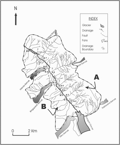
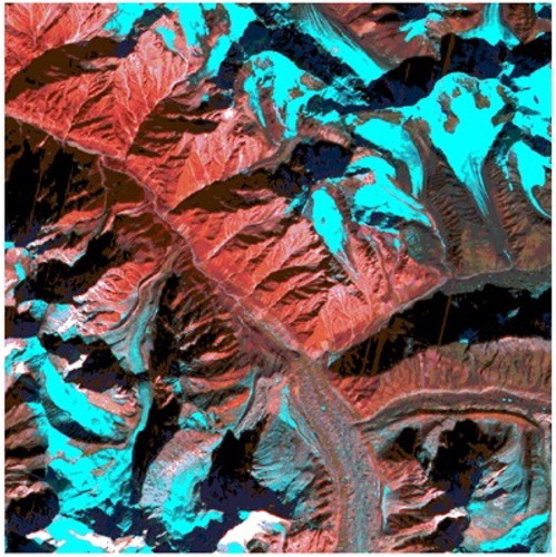
The present investigation aims to provide an understanding about the geomorphological and hydrological characteristics of Bhagirathi River sub-basin of Garhwal Himalaya and help to predict the water retention function of landscape, which, slow runoff, retain water and promote water infiltration. The quantitative assessment of drainage parameters is attempted in the Bhagirathi River sub-basin covering an area of 56.93 sq. km. located between the latitudes 30°44′N to 30°56′N and longitudes 79°04′E to 79°15′E, falling in the Survey of India toposheet No. 53 N/1 (Figure ).
Figure 1. Drainage networks and features in the Bhagirathi River sub-basin.
1.1. Bhagirathi River sub-basin
In Western Himalayan region, Gangotri glacier is one of the largest glaciers. Gangotri glacier originates from an altitude of about 7100 msl, extends for about 30 km covering nearly 75 sq. km of area. Its snout is situated at an altitude of 4000 msl. The climate in the Himalayan region varies with respect to changes in topography and aspect. The higher reaches upstream of Bhaironghati, are generally covered with snow and ice from November/December to March/April. Winters are rather prolonged and severe; snowfalls may occur for short spells between September and March, while January to May is marked by thunder showers and occasional hailstorms. Monsoon commences by the end of June and ceases by the middle of September; rainfall being the maximum in August. Occasionally, during monsoons, cloudbursts may cause heavy rains and floods. The rainfall decreases rapidly after September and is lowest in November. The Gaumukh–Gangotri region, however, generally receives lesser amount of rainfall. In this area, the day temperatures may be around 25°C in June–July, whereas the night temperature may be around 5°C during the summer months, and sub-zero during the winter months. Humidity varies from 70% to 90% during the monsoons and 35% to 40% during the pre-monsoon period. Round the year, the skies are usually clear to slightly clouded, except in the months of monsoon. Often the area experiences strong winds in the afternoon which are quite chilly during September/October.
The Gangotri–Gaumukh area is less vegetated as compared to the adjoining areas of Bhaironghati, Harsil, Dharali, Jhala and Bhatwari, due to scanty rainfall. Near Gangotri Township, Pine forests are found which continue up to Chirbas, beyond which and up to Bhujbas the “Bhoj” trees are present, and further upstream only some shrubs and herbs are found up to about 4400 m above this region, the area is generally barren, except for some lichen species.
1.2. Geology of the area
The early geological studies in the Gangotri and adjoining areas [Citation7,Citation8] were followed by Ali [Citation5], Agarwal and Kumar [Citation9], Singh and Mishra [Citation10,Citation11], Puri and Shukla [Citation12], [Citation13–15], have discussed the stratigraphy, structure and correlation of the formations in the Yamuna valley and upper Bhagirathi of the Himalaya and recognized four lithostratigraphic units: (1) Central Crystallines, (2) Martoli formation, (3) Dudatoli Group and (4) the Garhwal Group. Major faults separate each unit. The study area exposes intrusive of “Gangotri Granites” in the metasedimentaries of the Martoli Formation and composed of biotite, tourmaline, granites, granodiorites, aplites and pegmatite. The majority of the boulders found in the morainic material are of granites and thus seem to be derived from the “Gangotri Granites”.
The area under investigation extends from Gaumukh to Gangotri Township in the Gangotri glacier valley. The Bhagirathi River originates from the Gangotri glacier at an altitude of about 4000 m. The Gangotri glacier is fed by seven tributary glaciers. The three tributaries Chaturangi (sub-tributaries Vasuki and Suralaya), Raktavarn (sub-tributaries Swetvarn, Nilamber, Thelu and Pilapani) and Matri join on the right bank, while the other four tributaries Kirti, Meru, Bhrigupanth and Manda join on the left bank. These glaciers were probably joined together in the past, forming a huge glacier system. The fluctuations in climatic conditions have resulted in several advancements and retreats in the glacier body, through geologic time. It is evident due to the presence of morainic ridges and scattered morainic material at many locations in the Gangotri glacier valley. The Gangotri glacier valley is surrounded by high peaks and is endowed with perennial streams. The glacial, fluvioglacial and fluvial conditions have given rise to erosional and depositional features that have evolved into diversified landscapes in the valley.
2. Methodology
The drainage network of Bhagirathi River from Gaumukh to Chirbas has been analysed using the IRS-PAN satellite data (13 October 1999) Path/Row: 97/49 (Figure ) taking base map from SOI toposheet on 1:50,000. The different orders of the streams are identified following Strahler [Citation16], where all insequent streams above their first confluence point are considered as first-order stream. Two first-order streams join to form second-order stream, whereas two second-order streams join to form a third-order stream and so on. A higher order stream may receive a lower order stream without altering its designation, while a change occurs only after the confluence of two streams of similar order. All parameters of the sub-basin are mathematically calculated (Table ) and tabulated to have a quantitative assessment of the drainage characteristics of these sub-basins (Table ). The area, length and perimeter of the drainage basin are calculated using Curvimeter GIS software Arc view 3.2a and ERDAS 8.5 is used for digitization and computational purpose (Table ).
Figure 2. Drainage and lineament between Gaumukh to Chirbas in Bhagirathi River Sub-basin (A block, right side of watershed, B block, and left side of watershed).
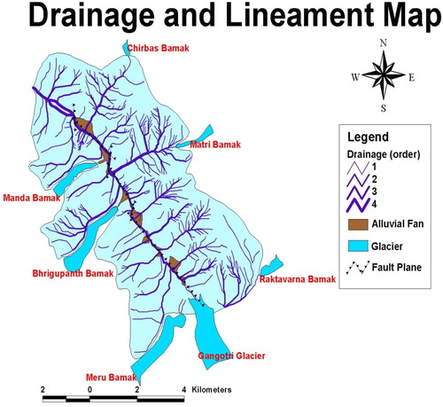
Table 1. Formulae used for the calculation of morphometric parameters.
Table 2. Stream analysis of Bhagirathi River sub-basin.
Table 3. Morphometric parameters of Bhagirathi River sub-basin.
2.1. Morphometric analysis
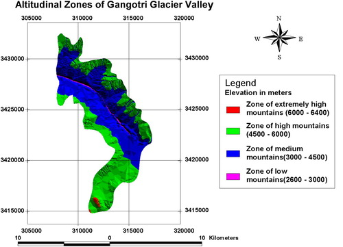
The study area, from Gaumukh to Chirbas, has a length of 11.98 km and occupies about 56.93 sq. km (Figure ). This is a perennially glaciated area with the long trunk glacier, i.e. the Gangotri glacier being fed by Raktavarna, Chaturangi, Swachhand, Meandi, Meru, Kirti and Ganohim Bamak tributary glaciers. The morphometric analysis can be broadly classified under three distinct classes of Linear, Areal and Relief Morphometry. The morphometric study of Bhagirathi sub-basin was performed using following parameters (Table ).
Figure 3. Altitudinal variations in Gangotri Glacier Valley.
3. Results and discussion
3.1. Linear morphometry
3.1.1. Bifurcation ratio
The bifurcation ratio of right blocks (A block) of the given sub-basin ranges from 1.63 to 2.09 with an average of 1.86. It varies from 1.36 to 5.5 in the left block (B block), average being 3.43. The higher bifurcation ratio of the left bank as compared to that of right bank evidently indicates a change in lithological characteristics of the two sub-basins. The plot of total number of stream segments with stream order shows a linear and inverse relationship (Figure ).
Figure 4. Stream segments with stream order in a linear and inverse relationship.
3.1.2. Length ratio
It represents the mean stream length ratio of any stream order with that of next stream of lower order. The length ratio of the right block sub-basin is 5.63 whereas that of the left block is 6.65. The logarithmic graph plot of the mean stream length and the stream order represents a positive correlation with slopes on both the banks. However, the total stream length shows the decrease for the second-order stream on the right bank indicating a transitional phase related to the higher slope on the right bank (Figure ).
Figure 5. Liss-III data of the study area.
3.2. Areal morphometry
It includes mathematical estimate of measurable areal parameters having of the drainage basin. Areal morphometry incorporates various components constituting the basin shape as also demonstrating the drainage texture in the basin.
3.2.1. Form factor
It represents the basin outer shape. In order to determine the shape of the drainage basin quantitatively, the circularity ratio, form factor and elongation ratio are the basic parameters that need to be calculated. Horton [Citation1,Citation17] explained the quantitative representation of outline form of drainage basin via a form factor Rf, that is dimensionless ratio of basin area to the square of basin length. Using the above equation, the basin shape of the Bhagirathi sub-basin area is 0.021.
3.2.2. Circularity ratio
It is the basin area ratio to the circular area having the same perimeter as the basin length; accordingly the circularity ratio for Bhagirathi River sub-basin is 0.57, which indicates sub-elongated basin.
3.2.3. Elongation ratio
It expresses diameter (D) ratio of a circle making similar area as that of the basin to the maximum basin length (L). Bhagirathi sub-basin elongation ratio is 0.72 suggesting that the given basin is commonly associated with strong relief and steep ground slopes. The elongation ratio ranging between 0.6 and 1.0 is indicative of a climatic and geological variability within the basin.
3.2.4. Drainage texture
It is the important parameter of basin morphometric studies, which is represented by the analysing the stream frequency and drainage density.
Drainage density and drainage intensity: It represents channel closeness in the basin. It is the ratio of total stream length and the area of the basin, and this ratio reduces to the inverse of length. The drainage density depends on the slope, rainfall, physical properties of the soil, vegetation, sediments and rock characteristics and several other factors that determine the erosion energy of surface runoff and the resistance to erosion of the surface materials. The computed drainage density of block A sub-basin is 1.51 km2 which represents relatively small basin than the right block with drainage density of 2.33 km2. The texture ratio of the entire basin was estimated as 2.23. Drainage Intensity for Black A and Block B basin was estimated as 1.57 and 0.808 respectively. While the infiltration estimated for both A and B basins is 6.484 and 2.025. It implies that the basin is well-drained and presents a remarkable fact about areal distribution. It is therefore visualized that initial resistivity of the terrain to erosion and infiltration-capacity terrain play more important role in determining drainage density than either rainfall or relief.
3.2.5. Stream frequency
The computed stream frequencies of the right and left blocks of given sub-basin are 4.13 and 2.15, respectively. These differences in the stream frequency of the two blocks are due to large-scale topographical variations as well as geological variation within the basin.
3.3. Relief morphometry
3.3.1. Total basin relief (H)
It is difference in elevation determined in metres. It represents the drainage system potential energy of a basin. The relief is estimated considering the elevation difference between highest and lowest points of the basin as
The highest point stands at 6000 m and the lowest point stands at 3600 m. The relief measure of the given sub-basin is therefore 2400 m.
3.3.2. Relief ratio
It is computed as the ratio between the total measured relief of the basin and the basin’s maximum length. The measured relief ratio of sub-basin is 0.20 that represents steepness of a basin and shows the erosional processes intensity acting on basin slopes. It further implies that the relief ratio has not played any important role in these sub-basins to determine their shape.
3.3.3. Ruggedness number and RHO coefficient
It usually depends on relief and drainage density of basin and is a dimensionless unit. The ruggedness number of the basin is 2.76. The RHO coefficient for both the basins A and B is estimated as 0.204 and 0.093. If the drainage density is increased while relief remains constant, the average horizontal distance between divides of adjacent channels is reduced, with an accompanying increase in slope steepness. Ruggedness number values are high, when slopes are steep and long.
3.3.4. Stream gradient
The ratio between the total vertical elevation drop from the source to the stream mouth and the corresponding horizontal distance provides the measure of the channel gradient. It contributes to the erosional characteristics of the basin. The channel slope of the Bhagirathi River basin is 2.92. The Bhagirathi River channel profile, when studied in detail, demonstrates that the stretch from Gaumukh to Bhujgari has a steep gradient while further downstream gentle slope is present. These observations indicate to the varying erosional capabilities in different stretches of Bhagirathi River. The high erosional potential between its sources to the Bhujgari speaks of the enormous quantum of sediment load being eroded off and transported downstream in this stretch. The flow regime of Bhagirathi River up to Bhujgari may be considered as erosional whereas the stretch further downstream from Bhujgari to Chirbas could be considered as depositional.
4. Conclusion
The study area from Gaumukh to Chirbas is characterized by third-order streams. While closely examining the fluvial drainage network between Gaumukh and Chirbas, a number of drainage morphometric parameters, viz. number of stream, stream order, bifurcation ratio, length ratio, drainage density, stream frequency, etc., were determined for the left and right banks of the Gangotri glacier valley. It is observed that the left and right banks of the Gangotri glacier valley have contrasting drainage characteristics. Both the valley walls in spite of having similar geological conditions show the development of pronounced drainage along the right bank as compared to the left bank. Low drainage density and the bifurcation ratios of the right and left banks correlate with the relative slopes in the basin area. The right bank has a gentler slope, broader flood plain and more dissected drainage than the left bank. There is variation in the areal distribution of the alluvial fans on both the banks. Study shows that the fans of the right bank occupy an area about 3.7 times that of the left bank. On the contrary, the glaciers on the left bank, Bhrigupanth, Meru and Manda, are located at an altitude of more than 4000 m and are nearly 500–800 m away from their trunk valley. Those on the right bank including the Matri, Raktavarna and Chirbas glaciers have their snout at an altitude of around 5000 m and are about 3–4 km away from the present day trunk valley. The morphometric parameters determined show that the right bank has 143 streams in all, whereas the left bank has only 56 streams. Total length of streams on the right bank is 54.32 km but that of the left has only 18.07 km.
The above contrasting morphometric parameters of both the banks can be ascribed to the recent movement along the NNW-SSE Gaumukh fault running from Gaumukh to Chirbas along the Bhagirathi River [Citation23,Citation24]. The relative up-liftment of the right valley wall along the Gaumukh fault has led to a process of rejuvenation and thereby a development of pronounced drainage over it at a higher pace as compared to the left bank. The denudational activities are dominant at right bank as compared to the left bank owing to neotectonic activities. It seems that these activities have resulted in the bulk supply of sediments to the river, which is responsible for regular land elevation and debris fan growth at right bank. As the shape of the basin governs the peak discharge time, there is a greater risk of flooding in Bhagirathi River between Bhojbas and Bhujgari during a peak ablation or monsoon period.
Disclosure statement
No potential conflict of interest was reported by the authors.
ORCID
Naval Kishore Tewari http://orcid.org/0000-0002-7003-1262
Anil Kumar Misra http://orcid.org/0000-0002-2678-2958
Anshumali Sharma http://orcid.org/0000-0002-0197-8655
References
- Horton RE. Erosional development of streams and their drainage basins; hydrophysical approach to quantitative morphology. Geo Soc Am Bull. 1945;56:275–370. doi: 10.1130/0016-7606(1945)56[275:EDOSAT]2.0.CO;2
- Strahler AN. Equilibrium theory of erosional slopes approached by frequency distribution analysis; Part 1. Am Jour Sci. 1950;248:673–696. 800–814. doi: 10.2475/ajs.248.10.673
- Schumm SA. Evolution of drainage system and slopes in Badlands at Perth Amboy, New Jersey. Geol Soc Am Bull. 1956;67:597–646. doi: 10.1130/0016-7606(1956)67[597:EODSAS]2.0.CO;2
- Subramanyam V. A quantitative analysis of two drainage basins around Sagar. M P Proc Inter Sc Acad. 1974;40A(1):77–99.
- Ali SA. Morphometric analysis of the Hiyunl River Basin at Rishikesh, Garhwal Himalayas, India. Proceedings of the IX Asian Conference on Remote Sensing; 23–29 November; Bangkok; 1988. pp. B-9-1-B-9-8.
- Sangewar CV, Singh RK, Siddiqui MA. Morphometric analysis vis-à-vis geomorphology of the Baspa basin, district Kinnaur. H. P. Geo Sur India Spl Pub. 2001;53:135–136.
- Griesbach H. Beitrage Zur Histologie des Blutes. Arch Mikroskov Anat. 1891;37:22–98. doi: 10.1007/BF02954291
- Auden JB. The snout of the Gangotri glacier, Tehri Garhwal. Rec Geol Surv India. 1937;72(2):135–140.
- Agarwal NC, Kumar G. Geology of the Upper Bhagirathi and Yamuna valleys, Uttarkashi district, Kumaun Himalaya. In: AG Jhingran, KS Valdiya, editor. Himalayan geology 3. New Delhi: W. I. H. G.; 1973. p. 1–23.
- Singh DS, Mishra A. Gangotri glacier characteristics, retreat and processes of sedimentation in the Bhagirathi valley. GSI Spl Pub. 2001;65(III):17–20.
- Singh DS, Mishra A. Role of tributary glaciers on landscape modification in the Gangotri glacier area, Garhwal Himalaya, India. Curr Sci. 2002;82(5):567–571.
- Puri VMK, Shukla SP. Tongue fluctuation studies on Gangotri glacier, Uttarkashi Distt., Uttar Pradesh. Geol Surv Ind Spl Pub. 1996;21(2):289–291.
- Tangri AK, Kumar R, Chandra R. Qualitative assessment of silt load in glacial streams through measures of their special response. A case study of Bhagirathi River at Bhojbas near the snout of Gangotri glacier, Garhwal Himalaya. Geol Surv Ind Spl Pub. 2001;53:123–129.
- Tangri AK. Shrinking glaciers of Uttaranchal: cause of concern and hope for the future. In: CC Pant, AK Sharma, editor. (Seminar Volume) Aspect of geology and environment of the Himalaya. Nainital: Gyanodaya Prakashan; 2002. p. 335–348.
- Naithani AK, Nainwal HC, Sati KK, et al. Geomorphological evidences of retreat of the Gangotri glacier and its characteristics. Curr Sci. 2001;80(1):87–94.
- Strahler AN. Quantitative geomorphology of drainage basins and channel networks. In: Vent TC, editor. Handbook of applied hydrology. New York (NY): Mcgraw Hill Book Company; 1964. Section 4-II.
- Horton RE. Drainage basin characteristics. Trans Am Geophys Union. 1932;13:350–361. doi: 10.1029/TR013i001p00350
- Miller VC. (1953). A quantitative geomorphic study of drainage basin characteristics in the Clinch Mountain area, Virginia and Tennessee Columbia University, Department of Geology, ONR, Geography Branch, New York, (Project NR 389042, Tech. Rept. 3).
- Faniran A. The index of drainage intensity – a provisional new drainage factor. Aust J Sci. 1968;31:328–330.
- Strahler AN. Hypsometric analysis of erosional topography. Bull Geol Soc Am. 1952;63:1117–1142. doi: 10.1130/0016-7606(1952)63[1117:HAAOET]2.0.CO;2
- Schumm SA. Sinuosity of alluvial rivers on the Great Plains. Bull Geol Soc Am. 1963;74:1089–1100. doi: 10.1130/0016-7606(1963)74[1089:SOAROT]2.0.CO;2
- Melton MA. The geomorphic and paleoclimatic significance of alluvial deposits in Southern Arizona. J Geol. 1965;73:1–38. doi: 10.1086/627044
- Bali R, Awasthi DD, Tewari NK. Neotectonic control on the geomorphic evolution of Gangotri glacier valley, Garhwal Himalaya. Gondwana Res. 2003;6(4):829–838. doi: 10.1016/S1342-937X(05)71028-5
- Bali R, Awasthi DD, Tewari NK. Record of neotectonic activity in Gangotri glacier valley: some significant observations. Proc. Workshop on Gangotri Glacier. Geol Survey India Spl Pub. 2004;80:79–86.