
Abstract
Previous satellite measurements and model simulations have shown that the Asian summer monsoon (ASM) anticyclone is co-located with higher concentrations of pollutants, which are emitted in the continental atmospheric boundary layer (ABL). Backward trajectory calculations show that the air at the 150-hPa level has the maximum frequency of ABL sources within 30 days over the most intensive convection regions and their downwind areas, which are not located within the ASM anticyclone, but rather at the southern flank or periphery of the ASM anticyclone. The upper tropospheric airs originated from the ABL sources include two parts: one from the ocean, which has the dominant impact to the south of 20°N, particularly over the South China Sea (SCS) and the west tropical Pacific Ocean; and another from the continent, which is dominant between 10°N and 30°N, particularly over the Bay of Bengal (BoB), continental India, the Arabian Sea, and the Arabian Peninsula. It is the latter part that forms the higher pollutant concentration within the ASM anticyclone as shown by satellite measurements. Air in the ABL sources (both polluted and unpolluted) converges to the intensive convection region in the lower troposphere, and then traverses the middle troposphere through a wide group of upward pipes, and finally to the upper troposphere. These pipes in the middle troposphere are defined by the ASM intensive convections and cover the south of continental India, the BoB, the Tibetan Plateau, the Indochina Peninsula, the SCS, and the Philippine Sea.
摘要
利用TRAJ3D模拟亚洲夏季风区空气的边界层来源。30天后向轨迹的统计结果显示,150hPa上,源于边界层的空气主要集中在亚洲夏季风反气旋南侧的深对流区及其下风向,而不是反气旋中心;将边界层源分为海洋(20°N以南的中国南海和西太平洋)和陆地(10–30°N之间的孟加拉湾、印度、环阿拉伯海地区)分别进行考察,携带高浓度污染物的陆地边界层空气在150hPa上的集中位置与卫星观测到的CO高值中心相对应,洁净的海洋边界层空气对反气旋东南侧的高浓度污染物起到稀释作用。
1. Introduction
In recent decades, satellite measurements and model simulations have recognized the Asian summer monsoon (ASM) circulation as a critical pathway for surface pollutants to transport to the stratosphere (Randel et al. Citation2010). In these studies, the impact of the ASM anticyclone on the distribution of atmospheric compositions in the upper troposphere and lower stratosphere (UTLS) has received much attention, because the anticyclone is co-located with persistently high levels of surface pollutants, such as carbon monoxide (CO; Li et al. Citation2005), methane (Park et al. Citation2004), and hydrogen cyanide (Randel et al. Citation2010). Some studies suggest that these enhancements are caused by upward transport of pollutants from the lower troposphere in deep convection associated with the ASM circulation to the upper troposphere, and confinement within the strong and isolated circulation of the anticyclone in the UTLS (Orbe, Waugh, and Newman Citation2015; Randel and Park Citation2006). The persistent deep convection in the ASM is located over a wide region, including the South Asian subcontinent and Bay of Bengal (BoB), the South China Sea (SCS) and the Philippine Sea, and the Tibetan Plateau and south slope of the Himalaya (Wright et al. Citation2011), most of which are far from the center of the anticyclone where tracers show extreme values.
Bergman et al. (Citation2013) identified a vertical conduit through which the atmospheric boundary layer (ABL) air traverses the mid-troposphere into the levels of the ASM anticyclone. The conduit is centered over Northeast India, Nepal, and southern Tibet, which is considered to represent the most efficient pathway from the ABL to the anticyclone. The conduit is located over the southern flank of the mean location of the anticyclone (which is co-located with persistently high levels of surface pollutants) and the northern flank of the mean location of strong vertical motion, but is co-located with neither (Fu et al. Citation2006).
As pointed by Pan et al. (Citation2016), the rapid vertical transport associated the ASM intensive convection is only effective up to the upper troposphere. The confinement by the ASM anticyclone will take over control afterwards (Park et al. Citation2009; Schoeberl and Dessler Citation2011). Stirring and mixing caused by the intraseasonal east–west oscillation of the anticyclone may play an essential role in spreading convectively pumped boundary layer pollutants to fill the anticyclone over a short vertical distance (Bergman et al. Citation2013; Pan et al. Citation2016).
The picture described above seems to provide a whole transport pathway in the ASM region, including rapid vertical convective transport from the ABL to the upper troposphere and later horizontal confinement by the anticyclone with slow vertical movement and synoptic-scale zonal propagation. But, there are a few issues, which are not clearly stated.
Many of the analyses mentioned above were based on surface pollutants, which are emitted over the continent and not over the oceans. From the study of Bergman et al. (Citation2013), the ABL dominant contributions to young air within the Asian anticyclone are from the Tibetan Plateau, and India and Southeast Asia, and continental sources dominate over oceanic sources. So, our first question is: what is the contribution of the ABL sources and the partitioning between continental and oceanic sources outside the ASM anticyclone, and are there some differences between within and outside the anticyclone? To put it another way, what is the difference in the contribution to young air in the upper troposphere between continental sources and oceanic sources? Additionally, we are interested in the pathway of the ABL air, so we also ask: where are the preferred locations of uplifting (a question similar to that asked by Pan et al. (Citation2016)), and are there differences in the ABL air transported to the upper troposphere by different pathways?
To deal with these questions, 30-day backward trajectory simulations are run for six summers in this study. We provide several new insights into the interpretation of the enhancement of surface pollutants within the ASM anticyclone.
2. Data and analysis method
2.1. Trajectory model
We perform kinematic backward trajectory calculations with a Lagrangian particle model to trace ABL sources of upper tropospheric air over the ASM region. The trajectory model is TRAJ3D, in which idealized particle locations are calculated by solving the equation of motion. More details of the model are given in Bowman (Citation1993) and Bowman and Carrie (Citation2002). The TRAJ3D model has shown good performance in investigating troposphere-to-stratosphere transport (Li and Bian Citation2015; Li, Bian, and Fan Citation2015; Randel and Park Citation2006).
In this study, the driving wind field for the trajectory model is from the European Centre for Medium-Range Weather Forecasts interim reanalysis (ERA-Interim) data-set, with a 0.75° × 0.75° horizontal grid (Dee et al. Citation2011). The wind data have a four-times-daily (0000, 0600, 1200, and 1800 UTC) temporal resolution.
2.2. Simulation design
We select 150 hPa as the level for the start points of our backward trajectory simulation of the air parcels within the ASM anticyclone. The ASM anticyclone is confined by two upper-tropospheric jets—the subtropical westerly jet to the north and the tropical easterly jet to the south—and the level of 150 hPa has the strongest confinement between these jets (Dethof et al. Citation1999; Gettelman et al. Citation2004, Citation2011). The 150-hPa level is well below the tropopause (in the range of 95–120 hPa) to the south of the subtropical westerly jet (Bian et al. Citation2012), so these air parcels are tropospheric, which enables the elimination of the effect of stratospheric processes.
The initial parcels are located at 150 hPa within (0°–60°N, 0°–180°E), which covers the whole ASM region, in horizontal grids of 0.75° × 0.75°. We release the trajectories four times daily (at 0000, 0600, 1200, and 1800 UTC) from 1 June through 31 August for six years (2009–2014). The backward simulation is calculated for 30 days for each trajectory until the trajectory reaches the ABL. To save on computation, a simple method is used to define the top of the ABL. When the trajectory is below the level of 85% of the local surface pressure, it is considered to be in the ABL (Bergman et al. Citation2013). The period of backward trajectory calculation is limited to 30 days, because a longer period would strongly dilute the ABL property retained in the parcel.
2.3. Satellite data
In this study, we use the CO data from the microwave limb sounder (MLS) instrument aboard the Aura spacecraft (Clerbaux et al. Citation2008; Schoeberl et al. Citation2006). The CO data from version 4/level 2 MLS products (Eos MLS Science Team Citation2011) is binned to construct gridded data on 1.5° (latitude) × 3° (longitude) grids. The average distribution of the CO volume mixing ratio at 147 hPa during summertime 2009–2014 (June–July–August; JJA) is shown in Figure , in which the JJA-mean geopotential height at 150 hPa is also overlain (from the ERA-Interim data-set). A significant feature is that CO has much higher concentrations within the ASM anticyclone, as reported previously (Li et al. Citation2005; Park et al. Citation2009). The CO concentration decreases very quickly from over 100 ppbv within the anticyclone core to typical stratospheric levels (below 50 ppbv) to the north of the subtropical westerly jet (about 40°N; Figure ), where the tropopause is significantly below the 150-hPa level. Obviously, this abrupt change is due to the different properties within (tropospheric) and outside (stratospheric) the anticyclone, and also to the horizontal transport barrier of the subtropical westerly jet and no effective upward transport from lower levels outside the anticyclone.
Figure 1. Summertime (June–July–August; JJA) distribution of the carbon monoxide (CO) concentration (color fill; units: ppbv) at 147 hPa during 2009–14, overlaid with the JJA-mean geopotential height at 150 hPa (contours; units: gpm). The geopotential height data are from the ERA-Interim data-set.
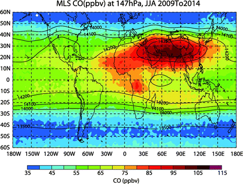
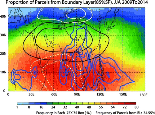
Figure 2. Percentage distribution (color fill) of air masses at the 150-hPa level originated from ABL sources within 30 days during summer (June–July–August; JJA) in 2009–14, overlaid with JJA-mean geopotential height (black solid contours; units: gpm; the area within the 14,300-gpm contour line is considered as the Asian summer monsoon), zonal wind (white contours; solid for westerly and dashed for easterly; units: m s−1) at 150 hPa, and OLR (blue contours, for 220, 210, 200, and 190 W m−2). The OLR data are from http://www.esrl.noaa.gov/psd/data/gridded/data.interp_OLR.html (Liebmann and Smith Citation1996).
To the south of the ASM anticyclone, however, despite being tropospheric, the 147-hPa level also has relatively lower CO (60–80 ppbv) over the tropical Indian Ocean, as well as the SCS and the Philippine Sea. Pan et al. (Citation2016) ascribed this strong difference to the confinement of the strong tropical easterly. But, these regions have particularly intensive convective activities, as indicated by the low values of outgoing longwave radiation (OLR) in Figure . Intensive convections imply that strong uplifts would transport pollutants from the ABL to the upper troposphere. Therefore, we deal with this issue next.
3. ABL sources
Figure shows the percentage of air masses at the 150-hPa level that are originated from the ABL within 30 days during JJA 2009–2014. At this level, the average ASM anticyclone can be denoted by the geopotential height contour of 14,300 gpm. To the north of the anticyclone, there are fewer air parcels (less than 20%) from ABL sources, which corresponds to the lower CO concentration there (less than 60 ppbv; Figure ). The lower percentage is due to the lower mean tropopause (more than 150 hPa) and the horizontal transport barrier of strong westerly wind (larger than 25 m s−1) there.
However, the maximum percentage (over 70%) region is not located within the anticyclone, but to its south. It covers the SCS and the Philippine sea, the Indochina Peninsula, BoB, Indian Peninsula, and Arabian Sea. These higher percentages are caused by the strong vertical transport of the intensive convections over the SCS and the Philippine sea, the Indochina Peninsula, and the BoB, and the horizontal transport to the west by the strong easterlies from the convective regions. But these higher percentages do not correspond to higher CO concentrations there; instead, we see relatively lower CO concentrations (60–80 ppbv). The maximum CO concentration is located within the anticyclone, which corresponds to modest percentages (40%–60%) of the ABL sources. This seems to be counterintuitive.
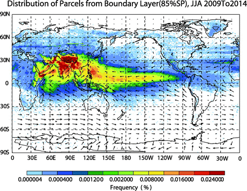
Let us take a first look at where the ABL sources are distributed. Figure shows the relative frequency distribution of all the ABL sources, which covers a wide area. The dominant region is from West Africa to the northern Indian Ocean (WA–NIO), and from the southern part of the Asian continent to the Pacific Ocean (AC–PO). This distribution of ABL sources is similar to that reported by Chen et al. (Citation2012), who traced the ABL sources of the stratospheric air-mass. The WA–NIO sources are related to the low-level Somali jet and the Arabian Sea branch of the Indian monsoon (Li and Zeng Citation2005). The ABL sources in the SCS and Philippine Sea are related to tropical cyclones. As a whole, all the sources exist in the boreal summertime intertropical convergence zone (ITCZ) (Li and Zeng Citation2005). The most prominent source region is the Tibetan Plateau and the Indian continent, as also revealed by several other studies (Bergman et al. Citation2013; Chen et al. Citation2012; Yan and Bian Citation2015).
Figure 3. Relative frequency distribution of all ABL parcels traced backwards from 150 hPa during summer (June–July–August; JJA) 2009–2014. The ABL top is defined as the level at 85% of the surface pressure. Overlaid is the mean surface wind during the same period.
Obviously, the ABL sources include both continents and oceans. Continental sources are dominant for anthropogenic pollution, while oceanic sources make very little contribution. So, we distinguish between their respective roles in the upper levels. The results are shown in Figure . When the ABL sources are separated into oceanic and continental, the percentage distribution changes of air masses at the 150-hPa level originating from the ABL within 30 days reveal a significantly different picture. For the oceanic sources, the higher percentage (over 40%) area moves further far away from the anticyclone in the southeastward direction, and the area influenced most by the oceanic sources is over the SCS and the Philippine Sea (Figure (a)). Over these areas, the average time for the first half parcels with shorter time from the ocean ABL to the 150-hPa level is also much shorter, at three to four days (Figure (b)). Since the oceanic sources are clean, the higher percentage and younger ABL oceanic air-mass makes these areas less polluted and have lower CO concentrations, as shown in Figure . Accordingly, the CO concentration within the ASM anticyclone is diluted down by relatively clean air masses from the oceanic ABL sources.
Figure 4. Percentage distribution (color fill) of air masses at the 150-hPa level originated from (a) oceanic and (c) continental sources within 30 days during summer (June–July–August; JJA) in 2009–14, overlaid with JJA-mean geopotential height (black solid contours; units: gpm). (b, d) Mean time for the first 50% of parcels with shorter time to reach the 150-hPa level from the (b) oceanic and (d) continental ABL.
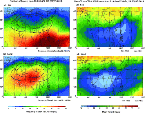
For the continental sources, the higher percentage (larger than 40%) area moves closer (northwards) to the ASM anticyclone, and the maximum is over the center of continental India, which corresponds to the shorter time (three to four days) for the continental ABL air transport to 150 hPa. It should be mentioned that the higher percentage area is not exactly co-located with the anticyclone, and features a slight southward shift with respect to the CO maximum distribution (see Figure ). This shift can be ascribed to the dilution of oceanic sources with less pollution, whose influence gradually decreases from within to outside the anticyclone.
4. Pathway from the ABL to the upper troposphere
Bergman et al. (Citation2013) described the air-mass transport pathway from the ABL to the ASM anticyclone as a conduit mainly limited to the continental area and featuring strong convection. However, the conduit identified in this paper (see Supplemental Material) includes a much wider pathway from the ABL to the upper troposphere over the Asian continent and low-latitude ocean in the same longitudinal range.
5. Summary
Previous satellite measurements and model simulations have shown that the ASM anticyclone is co-located with higher concentrations of pollutants, which are emitted in the continental ABL. The pollutant pathway from the ABL to the ASM anticyclone and the ASM anticyclone’s trapping effect on these pollutants have already received much attention. However, some parts of this transportation picture are challenged by the backward trajectory investigation in this paper. To investigate the transport to the upper troposphere from the boundary sources, a backward trajectory simulation is conducted to identify the ABL sources for the air masses in the upper troposphere over Asia and their pathways. The backward trajectory calculations show that the air at the 150-hPa level has the maximum frequency of ABL sources within 30 days over the most intensive convection regions (indicated by lower OLR) and their downwind areas, which are not located within the ASM anticyclone, but rather at the southern flank or periphery of the ASM anticyclone. The upper-tropospheric airs originated from the ABL sources include two parts: one from the ocean, which has the dominant impact to the south of 20°N, particularly over the SCS and the west tropical Pacific Ocean; and another from the continent, which is dominant between 10°N and 30°N, particularly over the BoB, continental India, the Arabian Sea, and the Arabian Peninsula. It is the latter part that forms the higher pollutant concentrations within the ASM anticyclone as shown by satellite measurements. The ABL sources cover a wide area from West Africa to the northern Indian Ocean, and from the southern part of the Asian continent to the Pacific Ocean, which takes the boreal summertime ITCZ as a central axis. Air in the ABL sources (both polluted and unpolluted) converges to the intensive convection region in the lower troposphere, and then traverses the middle troposphere through a wide group of upward pipes, and finally to the upper troposphere. These pipes in the middle troposphere are defined by the ASM intensive convections and cover the south of continental India, the BoB, the Tibetan Plateau, the Indochina Peninsula, the SCS, and the Philippine Sea. This larger conduit is different from that reported by Bergman et al. (Citation2013), which is only concerned with the pathway from the ABL to the ASM anticyclone and is dominantly limited to the continental area with strong convection.
Disclosure statement
No potential conflict of interest was reported by the authors.
Funding
This work was supported by the National Natural Science Foundation of China [grant number 91337214], [grand number 41675040].
Supplemental data
Supplemental data for this article can be accessed at https://doi.org/10.1080/16742834.2017.1344089.
Online_Supplementary_Material.pdf
Download PDF (377.4 KB)Related Research Data
References
- Bergman, J. W., F. Fierli, E. J. Jensen, S. Honomichl, and L. L. Pan. 2013. “Boundary Layer Sources for the Asian Anticyclone: Regional Contributions to a Vertical Conduit.” Journal of Geophysical Research: Atmospheres 118: 2560–2575.10.1002/jgrd.50142
- Bian, J., L. L. Pan, L. Paulik, H. Vomel, H. B. Chen, and D. R. Lu. 2012. “In Situ Water Vapor and Ozone Measurements in Lhasa and Kunming during the Asian Summer Monsoon.” Geophysical Research Letters 39 (19). doi:10.1029/2012GL052996.
- Bowman, K. P.. 1993. “Large-scale is Entropic Mixing Properties of the Antarctic Polar Vortex From Analyzed Winds.” Journal of Geophysical Research: Atmospheres. 98: 23013–23027.10.1029/93JD02599
- Bowman, K. P., and G. D. Carrie. 2002. “The Mean-meridional Transport Circulation of the Troposphere in an Idealized GCM.” Journal of the Atmospheric Sciences 59: 1502–1514.10.1175/1520-0469(2002)059<1502:TMMTCO>2.0.CO;2
- Chen, B., X. D. Xu, S. Yang, and T. L. Zhao. 2012. “Climatological Perspectives of Air Transport from Atmospheric Boundary Layer to Tropopause Layer Over Asian Monsoon Regions During Boreal Summer Inferred from Lagrangian Approach.” Atmospheric Chemistry and Physics Discussions 12: 4185–4219. doi:10.5194/acp-12-5827-2012.
- Clerbaux, M., M. George, S. Turquety, K. A. Walker, B. Barret, P. Bernath, C. Boone, et al. 2008. “CO Measurements from the ACE-FTS Satellite Instrument: Data Analysis and Validation Using Ground-based, Airborne and Spaceborne Observations.” Atmospheric Chemistry and Physics 8: 2569–2594.10.5194/acp-8-2569-2008
- Dee, D. P., S. M. Uppala, A. J. Simmons, P. Berrisford, P. Poli, S. Kobayashi, U. Andrae, et al. 2011. “The ERA-interim Reanalysis: Configuration and Performance of the Data Assimilation System.” Quarterly Journal of the Royal Meteorological Society 137 (656): 553–597.10.1002/qj.v137.656
- Dethof, A., A. O’Neill, J. M. Slingo, and H. G. J. Smit. 1999. “A Mechanism for Moistening the Lower Stratosphere Involving the Asian Summer Monsoon.” Quarterly Journal of the Royal Meteorological Society 125: 1079–1106.10.1002/qj.497.v125:556
- Eos MLS Science Team. 2011. MLS/Aura Near-Real-Time L2 Carbon Monoxide (CO) Mixing Ratio V003. Greenbelt, MD: Goddard Earth Sciences Data and Information Services Center (GES DISC).
- Fu, R., Y. L. Hu, J. S. Wright, J. H. Jiang, R. E. Dickinson, M. X. Chen, M. Filipiak, and el al. 2006. “Short Circuit of Water Vapor and Polluted Air to the Global Stratosphere by Convective Transport Over the Tibetan Plateau.” Proceedings of the National Academy of Sciences 103: 5664–5669. doi:10.1073/pnas.0601584103.
- Gettelman, A., D. E. Kinnison, T. J. Dunkerton, and G. P. Brasseur. 2004. “Impact of Monsoon Circulation on the Upper Troposphere and Lower Stratosphere.” Journal of Geophysical Research: Atmospheres 109: D22101. doi:10.1029/2004JD004878.
- Gettelman, A., P. Hoor, L. L. Pan, W. J. Randel, M. I. Hegglin, and T. Birner. 2011. “The Extratropical Upper Troposphere and Lower Stratosphere.” Reviews of Geophysics. 49: RG3003. doi:10.1029/2011RG000355.
- Li, D., and J. C. Bian. 2015. “Observation of a Summer Tropopause Fold by Ozonesonde at Changchun, China: Comparison With reanalysis and Model Simulation.” Advances in Atmospheric Sciences 32 (10): 1354–1364. doi:10.1007/s00376-015-5022-x.
- Li, J. P., and Q. C. Zeng. 2005. “A new Monsoon Index, Its Interannual Variability and Relation with Monsoon Precipitation.” Climatic and Environmental Research 10 (3): 351–365.
- Li, Q. B., J. H. Jiang, D. L. Wu, W. G. Read, N. J. Livesey, J. W. Waters, Y. S. Zhang, B. Wang, M. J. Filipiak, C. P. Davis, and S. Turquety. 2005. “Convective outflow of South Asian pollution: A global CTM simulation compared with EOS MLS observations.” Geophysical Research Letters 32: L14826. doi:10.1029/2005GL022762.
- Li, D., J. C. Bian, and Q. J. Fan. 2015. “A Deep Stratospheric Intrusion Associated with an Intense Cut-off Low Event Over East Asia.” Science China: Earth Sciences 58: 116–128. doi:10.1007/s11430-014-4977-2.
- Liebmann, B., and C. A. Smith. 1996. “Description of a Complete (Interpolated) Outgoing Longwave Radiation Dataset.” Bulletin of the American Meteorological Society 77: 1275–1277.
- Orbe, C., D. Waugh, and P. Newman. 2015. “Air-mass Origins in the Tropical Lower Stratosphere: The Influence of the Asian Boundary Layer.” Geophysical Research Letters 42: 4240–4248. doi:10.1002/2015GL063937.
- Pan, L., S. B. Honomichl, D. E. Kinnison, M. Abalos, W. J. Randel, J. W. Bergman, and J. Bian. 2016. “Transport of Chemical Tracers From the Boundary Layer to Stratosphere Associated with the Dynamics of the Asian Summer Monsoon.” Journal of Geophysical Research: Atmospheres 121: 14159–14174. doi:10.1002/2016JD025616.
- Park, M., W. J. Randel, D. E. Kinnison, R. R. Garcia, and W. Choi. 2004. “Seasonal Variation of Methane, Water Vapor, and Nitrogen Oxides Near the Tropopause: Satellite Observations and Model Simulations.” Journal of Geophysical Research: Atmospheres 109: D03302. doi:10.1029/2003JD003706.
- Park, M., W. J. Randel, L. K. Emmons, and N. J. Livesey. 2009. “Transport Pathways of Carbon Monoxide in the Asian Summer Monsoon Diagnosed from Model of Ozone and Related Tracers (MOZART).” Journal of Geophysical Research: Atmospheres 114: D08303.
- Randel, W. J., and M. Park. 2006. “Deep Convective Influence on the Asian Summer Monsoon Anticyclone and Associated Tracer Variability Observed with Atmospheric Infrared Sounder (AIRS).” Journal of Geophysical Research: Atmospheres 111: D12314. doi:10.1029/2005JD006490.
- Randel, W. J., M. Park, L. Emmons, D. Kinnison, P. Bernath, K. A. Walker, C. Boone, and H. Pumphrey. 2010. “Asian Monsoon Transport of Pollution to the Stratosphere.” Science 328: 611–613. doi:10.1126/science.1182274.
- Schoeberl, M. R., and A. E. Dessler. 2011. “Dehydration of the Stratosphere.” Atmospheric Chemistry and Physics 11: 8433–8446. doi:10.5194/acp-11-8433-2011.
- Schoeberl, M. R., A. R. Douglass, E. Hilsenrath, P. K. Bhartia, R. Beer, J. W. Waters, et al. 2006. “Overview of the EOS Aura Mission.” IEEE Transactions on Geoscience and Remote Sensing 44: 1066–1074. doi:10.1109/TGRS.2005.861950.
- Wright, J. S., R. Fu, S. Fueglistaler, Y. S. Liu, and Y. Zhang. 2011. “The Influence of Summertime Convection over Southeast Asia on Water Vapor in the Tropical Stratosphere.” Journal of Geophysical Research: Atmospheres 116: D12302. doi:10.1029/2010JD015416.
- Yan, R. C., and J. C. Bian. 2015. “Tracing the Boundary Layer Sources of Carbon Monoxide in the Asian Summer Monsoon Anticyclone Using WRF-Chem.” Advances in Atmospheric Sciences 32 (7): 943–951. doi:10.1007/s00376-014-4130-3.