

ABSTRACT
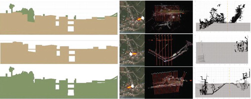
This study retrieves icon-centered activities in Pingxi and Jingtong, Taiwan, and re-interprets them through a railroad peripheral of the old streets in a digital form. The method to retrieve urban images comes from the modeling of multiple sources as in 3D ground scans and photogrammetry. The latter was conducted on ground level and in the air using UAV. After clarifying the interrelationship between the old streets and this railroad by sections, the railroad is represented as an elevated axis from ground level, from a bridge in the air, to a hillside, which can be seen in VR or AR mode. The scan data have been very useful to interconnect the relationships among old streets, residences, rivers, and the railroad in 3D. The railroad, a cultural icon, is now part of a geo-information system with great detail and will also serve as a cultural reference for the interaction between tourism and heritage.
GRAPHICAL ABSTRACT
KEYWORDS:
Acknowledgements
This research is sponsored by the Ministry of Science and Technology of Taiwan. The involved project number is MOST 105-2221-E-011-014-MY2. The authors express sincere appreciation for this support.
ORCID
Naai-Jung Shih http://orcid.org/0000-0001-9111-6321
Pei-Huang Diao http://orcid.org/0000-0003-4535-3291